Next Issue
Volume 15, January-1
Previous Issue
Volume 14, December-1
 
 
water-logo

Journal Browser

Journal Browser

Water, Volume 14, Issue 24 (December-2 2022) – 156 articles

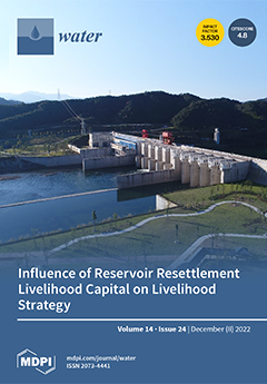
Cover Story (view full-size image): As one of the 172 major water conservation and water supply projects in China, the Wuxikou Water Control Project is a large (II) reservoir in the middle reaches of the Yangtze River main stream in Jiangxi Province. The main function of the reservoir is flood control, water supply, and power generation, which play important roles in promoting the sustainable development of the regional economy. Taking this project as the study area is representative and typical; through empirical analysis of the influence of livelihood capital on the choice and transformation of livelihood strategies, it can reflect the relationship between the livelihood strategies of reservoir resettled households, help to realize the sustainable development of resettled households, and transfer experience to existing or upcoming resettlement projects in other regions. View this paper
  • Issues are regarded as officially published after their release is announced to the table of contents alert mailing list.
  • You may sign up for e-mail alerts to receive table of contents of newly released issues.
  • PDF is the official format for papers published in both, html and pdf forms. To view the papers in pdf format, click on the "PDF Full-text" link, and use the free Adobe Reader to open them.
Order results
Result details
Section
Select all
Export citation of selected articles as:
14 pages, 1601 KiB  
Article
Equilibrium, Kinetic and Thermodynamic Studies for the Adsorption of Metanil Yellow Using Carbonized Pistachio Shell-Magnetic Nanoparticles
by Adnan, Muhammad Omer, Behramand Khan, Inkisar Khan, Muhammad Alamzeb, Farah Muhammad Zada, Ihsan Ullah, Rahim Shah, Mohammed Alqarni and Jesus Simal-Gandara
Water 2022, 14(24), 4139; https://doi.org/10.3390/w14244139 - 19 Dec 2022
Cited by 5 | Viewed by 2572
Abstract
The cost-effective adsorbents of carbonized pistachio shell magnetic nanoparticles (CPSMNPs) were synthesized. SEM, EDX, and BET characterized the prepared CPSMNPs. The CPSMNPs were used as adsorbents to remove Metanil Yellow (MY) dye. The adsorption of MY was investigated with the effect of pH, [...] Read more.
The cost-effective adsorbents of carbonized pistachio shell magnetic nanoparticles (CPSMNPs) were synthesized. SEM, EDX, and BET characterized the prepared CPSMNPs. The CPSMNPs were used as adsorbents to remove Metanil Yellow (MY) dye. The adsorption of MY was investigated with the effect of pH, contact time, initial dye concentration, adsorbent dose, and temperature. The SEM image of CPSMNPs reveals fine particles with an average size of 400–700 nm and a substantial surface area increase (112.58 m2/g). The EDX analysis confirms the carbonization of PS to CPS and the successful impregnation of Fe3O4 nanoparticles. CPSMNPs showed excellent adsorption efficiency, i.e., 94% for adsorption of MY of 10 mL of 100 ppm MY at optimum conditions. Kinetics data fit pseudo-second-order kinetics. The Langmuir isotherm better represents the equilibrium data with the spontaneous sorption process. This study investigates that the synthesized nanoparticles have an excellent texture and can be used as a special adsorbent for the adsorption of wastewater pollutants like MY. Full article
(This article belongs to the Special Issue Water Treatment by Adsorption and Catalytic Methods)
Show Figures

Graphical abstract

16 pages, 9139 KiB  
Article
Advanced Treatment of Laundry Wastewater by Electro-Hybrid Ozonation–Coagulation Process: Surfactant and Microplastic Removal and Mechanism
by Jiahao Luo, Xin Jin, Yadong Wang and Pengkang Jin
Water 2022, 14(24), 4138; https://doi.org/10.3390/w14244138 - 19 Dec 2022
Cited by 16 | Viewed by 4935
Abstract
Laundry wastewater is supposed to be one of the most important sources of surfactants and microplastics in the wastewater treatment plant. Consequently, the aim of the study was evaluating the performance and mechanism of the electro-hybrid ozonation–coagulation (E-HOC) process for the removal of [...] Read more.
Laundry wastewater is supposed to be one of the most important sources of surfactants and microplastics in the wastewater treatment plant. Consequently, the aim of the study was evaluating the performance and mechanism of the electro-hybrid ozonation–coagulation (E-HOC) process for the removal of surfactants and microplastics. In this study, the efficiency of the E-HOC process for surfactant and microplastic removal was examined at different current densities and ozone dosages. Under the optimal reaction conditions (current density 15 mA·cm−2, ozone dosage 66.2 mg·L−1), both the removal efficiency of surfactant and microplastic can reach higher than 90%. Furthermore, the mechanism of surfactant and microplastic removal was investigated by electron paramagnetic resonance (EPR) and Fourier transform infrared spectroscopy (FT-IR). The results showed that the E-HOC (carbon fiber cathode) system can produce more reactive oxygen species (ROS), which can significantly improve the removal of the contaminants. In addition, the shape, size and abundance of the microplastics were analyzed. It was found that the shape of the microplastics in laundry wastewater is mainly fiber. Microplastics less than 50 μm account for 46.9%, while only 12.4% are larger than 500 μm. The abundance of microplastics in laundry wastewater ranges between 440,000 and 1,080,000 items per 100 L. The analysis of microplastics by FT-IR showed that most of the microplastics in laundry wastewater were polyethylene, nylon and polyester. These results indicated that the E-HOC process can effectively remove surfactants and microplastics from laundry wastewater. Full article
(This article belongs to the Special Issue Advanced Oxidation Processes for Emerging Contaminant Removal)
Show Figures

Figure 1

10 pages, 4411 KiB  
Article
Synthesis of Fumed-Pr-Pi-TCT as a Fluorescent Chemosensor for the Detection of Cyanide Ions in Aqueous Media
by Sepideh Saberi Afshar, Ghodsi Mohammadi Ziarani, Fatemeh Mohajer, Alireza Badiei, Siavash Iravani and Rajender S. Varma
Water 2022, 14(24), 4137; https://doi.org/10.3390/w14244137 - 19 Dec 2022
Cited by 3 | Viewed by 2922
Abstract
In this research, fumed silica scaffolds modified via treatment with (3-chloropropyl)-triethoxysilane, piperazine, and trichlorotriazine groups were deployed for the specific detection of cyanide ions, thus paving the way for the detection of environmental hazards and pollutants with high specificity. Fumed-propyl -piperazine-trichlorotriazine (fumed-Pr-Pi-TCT) was [...] Read more.
In this research, fumed silica scaffolds modified via treatment with (3-chloropropyl)-triethoxysilane, piperazine, and trichlorotriazine groups were deployed for the specific detection of cyanide ions, thus paving the way for the detection of environmental hazards and pollutants with high specificity. Fumed-propyl -piperazine-trichlorotriazine (fumed-Pr-Pi-TCT) was synthesized in three steps starting from fume silica. It was functionalized subsequently using 3-(choloropropyl)-trimethoxysilane, piperazine, and trichlorotriazine, and then, the product was characterized through several methods including Fourier-transform infrared spectroscopy (FTIR) spectrum, thermogravimetric analysis (TGA), and scanning electron microscopy (SEM). Fumed-Pr-Pi-TCT was exposed as a nanoparticle sensor to a range of different anions in aqueous media. This novel sensor could detect cyanide ions as a hazardous material, with the limit of detection being 0.82 × 10⁻⁴ M. Full article
Show Figures

Figure 1

16 pages, 1030 KiB  
Article
Ecotoxicological and Chemical Approach to Assessing Environmental Effects from Pesticide Use in Organic and Conventional Rice Paddies
by Fulvio Onorati, Andrea Tornambé, Andrea Paina, Chiara Maggi, Giulio Sesta, Maria Teresa Berducci, Micol Bellucci, Enrico Rivella and Susanna D’Antoni
Water 2022, 14(24), 4136; https://doi.org/10.3390/w14244136 - 19 Dec 2022
Cited by 4 | Viewed by 2081
Abstract
Despite laws and directives for the regulation and restriction of pesticides in farming, the large use of Plant-Protection Products (PPPs) in paddy fields is a relevant worldwide cause of environmental contamination. The aim of this work is to evaluate the environmental impact due [...] Read more.
Despite laws and directives for the regulation and restriction of pesticides in farming, the large use of Plant-Protection Products (PPPs) in paddy fields is a relevant worldwide cause of environmental contamination. The aim of this work is to evaluate the environmental impact due to the use of PPPs by using an integrated approach based on chemical analyses and ecotoxicological hazard assessment, supported by statistical tools, in order to overcome the issues related to traditional tabular evaluation. Samples of soil and water of seven conventional and organic paddies located in Northern Italy were examined for two years. The results evidenced a direct relationship between the presence of Oxadiazon in water and bioassay responses as the main cause of the toxicity measured. This phenomenon affected both biological and conventional rice fields, due to the free circulation of water through irrigation canals. Therefore, the implementation of organic districts with water circulation isolated from conventional fields represents a simple and effective countermeasure to safeguard the agricultural practices of organic crops. Full article
(This article belongs to the Special Issue Ecotoxicological Risk in Aquatic Environments)
Show Figures

Figure 1

21 pages, 12841 KiB  
Article
Channel Bed Adjustment of the Lowermost Yangtze River Estuary from 1983 to 2018: Causes and Implications
by Ming Tang, Heqin Cheng, Yijun Xu, Hao Hu, Shuwei Zheng, Bo Wang, Zhongyong Yang, Lizhi Teng, Wei Xu, Erfeng Zhang and Jiufa Li
Water 2022, 14(24), 4135; https://doi.org/10.3390/w14244135 - 19 Dec 2022
Cited by 6 | Viewed by 2605
Abstract
Deltaic channels are significant landforms at the interface of sediment transfer from land to oceanic realms. Understanding the dynamics of these channels is urgent because delta processes are sensitive to climate change and adjustments in human activity. To obtain a better understanding of [...] Read more.
Deltaic channels are significant landforms at the interface of sediment transfer from land to oceanic realms. Understanding the dynamics of these channels is urgent because delta processes are sensitive to climate change and adjustments in human activity. To obtain a better understanding of the morphological processes of large deltaic channels, this study assessed the evolution and response mechanism of the South Channel and South Passage (SCSP) in the Yangtze Estuary between 1983 to 2018 using hydrology, multibeam echo sounding and historical bathymetry datasets. Decadal changes in riverbed volume and erosion/deposition patterns in the SCSP were assessed. The results showed that the SCSP experienced substantial deposition with a total volume of 26.90 × 10⁷ m3 during 1983–2002, but significant bed erosion with a total volume of 26.04 ×10⁷ m3 during 2003–2010. From 2011 to 2018, the estuarine riverbeds shifted from erosive to depositional, even though the deposition was relatively marginal (0.76 ×10⁷ m3). We inferred that the SCSP have most likely changed from a net erosion phase to a deposition stage in response to local human activities including sand mining, river regulation project, and Deep Water Channel Regulation Project). The channel aggradation will possibly continue considering sea level rise and the ongoing anthropogenic impacts. This is the first field evidence reporting that the lowermost Yangtze River is reaching an equilibrium state in terms of channel erosion and, in fact, the Yangtze River Estuary channels are beginning to aggrade. The findings have relevant implications for the management of the Yangtze River and other lowland alluvial rivers in the world as global sea level continues rising and human intervention on estuarine systems persists. Full article
(This article belongs to the Special Issue Estuarine and Coastal Morphodynamics and Dynamic Sedimentation)
Show Figures

Figure 1

25 pages, 9729 KiB  
Article
Long-Term Temporal Flood Predictions Made Using Convolutional Neural Networks
by Hau-Wei Wang, Gwo-Fong Lin, Chih-Tsung Hsu, Shiang-Jen Wu and Samkele Sikhulile Tfwala
Water 2022, 14(24), 4134; https://doi.org/10.3390/w14244134 - 19 Dec 2022
Cited by 7 | Viewed by 2370
Abstract
This study proposes a method for predicting the long-term temporal two-dimensional range and depth of flooding in all grid points by using a convolutional neural network (CNN). The deep learning model was trained using a large rainfall dataset obtained from actual flooding events, [...] Read more.
This study proposes a method for predicting the long-term temporal two-dimensional range and depth of flooding in all grid points by using a convolutional neural network (CNN). The deep learning model was trained using a large rainfall dataset obtained from actual flooding events, and the corresponding raster flood data computed using a physical model. Various rainfall distributions (at different times or over different accumulation periods), the mesh of the simulated area, and the topography of the simulated area were considered when evaluating the performance of two CNNs: a simple CNN and Inception CNN. Neither CNN architecture could converge when the coordinate information was not included in the input data. Adding terrain elevation information to the rainfall data already containing coordinates increased the accuracy of flood prediction. Our findings indicated that in the proposed method, real-time flooding observation data are not required for corrections, and we concluded that the method can be used for long-term flood forecasting. Our model can accurately pinpoint when the water level changes from rising to falling. Once meteorological forecasted rainfall data are obtained, a corresponding long-term forecast of the two-dimensional flooding range and depth can be obtained within seconds. Full article
Show Figures

Figure 1

15 pages, 6004 KiB  
Article
Collaborative Ecological Flow Decision Making under the Bengbu Sluice Based on Ecological-Economic Objectives
by Ying Pei, Baohong Lu, Yang Song, Yan Yang, Xinyue Feng and Wenlong Shen
Water 2022, 14(24), 4133; https://doi.org/10.3390/w14244133 - 19 Dec 2022
Cited by 2 | Viewed by 1649
Abstract
The construction of dams destroys the integrity of a watershed system and the continuity of natural water flow, creating a watershed with segmented and fragmented rivers. This, in turn, affects and even destroys the health and stability of the watershed ecosystem. This study [...] Read more.
The construction of dams destroys the integrity of a watershed system and the continuity of natural water flow, creating a watershed with segmented and fragmented rivers. This, in turn, affects and even destroys the health and stability of the watershed ecosystem. This study selected the downstream area of Bengbu Sluice in the Huai River Basin of China as the study area. To address the increasingly prominent ecosystem degradation in the Huai River Basin, ecological flow thresholds were determined using habitat simulation and hydrological approaches for mutual validation. A multi-objective synergistic decision model incorporating ecological and socioeconomic objectives was developed to coordinate the economic and ecological water use conflicts in the study area. The optimal coordinated solution for the ecological flow of important biological habitats in the basin was determined with the multi-objective synergistic method. The results demonstrated that a coordinated solution could guarantee the ecological and economic water demands of the basin. The findings of this study can be used as a reference for scientific guidelines on future ecological operations in dam-controlled rivers. Full article
(This article belongs to the Special Issue Watershed Aquatic Assessment and Management of Water)
Show Figures

Figure 1

20 pages, 3174 KiB  
Article
A Case Study of a 10-Year Change in the Vegetation and Water Environments of Volcanic Mires in South-Western Japan
by Akira Haraguchi
Water 2022, 14(24), 4132; https://doi.org/10.3390/w14244132 - 19 Dec 2022
Viewed by 1465
Abstract
Variations in the groundwater environments and dominant species of volcanic mire vegetation were monitored for 10 years in a volcanic area in south-western Japan. The correlation between changes in groundwater environments and vegetation revealed that changes in water environments determine the dominant species [...] Read more.
Variations in the groundwater environments and dominant species of volcanic mire vegetation were monitored for 10 years in a volcanic area in south-western Japan. The correlation between changes in groundwater environments and vegetation revealed that changes in water environments determine the dominant species of volcanic mire vegetation. The amount of spring water supplied to the mire vegetation determines the water-table depth and the subsequent nutrient supply. The Sphagnum spp. coverage decreased with increasing base cation concentrations, particularly the Ca2+ concentration up to 40 mg/L. The Moliniopsis japonica coverage increased with the decreasing Sphagnum spp. coverage. The nutritional variables of water supplied to vegetation affected by volcanic activity changed the type of dominant species. A 10-year change in vegetation in the volcanic mires revealed that vegetation succession in volcanic mires evolved from ombrogenous to minerogenous and from minerogenous to ombrogenous communities. The water environment promoted changes in the dominant species. Full article
Show Figures

Figure 1

14 pages, 3998 KiB  
Article
Hydrogeochemical Characteristics and Groundwater Quality in a Coastal Urbanized Area, South China: Impact of Land Use
by Chunyan Liu, Qinxuan Hou, Yetao Chen and Guanxing Huang
Water 2022, 14(24), 4131; https://doi.org/10.3390/w14244131 - 19 Dec 2022
Cited by 7 | Viewed by 2633
Abstract
Land use transformation accompanied with various human activities affects groundwater chemistry and quality globally, especially in coastal urbanized areas because of complex human activities. This study investigated the impact of land use on groundwater chemistry and quality in a coastal alluvial aquifer (CAA) [...] Read more.
Land use transformation accompanied with various human activities affects groundwater chemistry and quality globally, especially in coastal urbanized areas because of complex human activities. This study investigated the impact of land use on groundwater chemistry and quality in a coastal alluvial aquifer (CAA) of the Pearl River Delta where urbanization continues. A fuzzy synthetic evaluation method was used to evaluate the groundwater quality. Besides, factors controlling groundwater chemistry and quality in the CAA were discussed by using a principal components analysis (PCA). Nearly 150 groundwater samples were collected. All samples were filtered on-site and stored at 4 °C until the laboratory procedures could be performed. Nineteen chemical parameters including pH, dissolved oxygen, redox potential, total dissolved solids, K+, Na+, Ca2+, Mg2+, NH4+, HCO3, NO3, SO42−, Cl, I, NO2, Pb, Mn, Fe, and As were analyzed. Results show that groundwater chemistry in the CAA was dominated by Ca-HCO3 and Ca·Na-HCO3 facies. In addition, groundwater with NO3 facies was also present because of more intensive human activities. In the CAA, 61.8% of groundwaters were fit for drinking, and 10.7% of groundwaters were undrinkable but fit for irrigation, whereas 27.5% of groundwaters were unfit for any purpose. Poor-quality groundwaters in urban and agricultural areas were 1.1–1.2 times those in peri-urban areas, but absent in the remaining area. Groundwater chemistry and quality in the CAA was mainly controlled by five factors according to the PCA. Factor 1 is the release of salt and NH4+ from marine sediments, and the infiltration of domestic and septic sewage. Factor 2 is agricultural activities related to the irrigation of river water, and the use of chemical fertilizers. Factor 3 is the industrial pollution related to heavy metals and acid deposition. Factor 4 is the input of anthropogenic reducing sewage inducing the reductive dissolution of As-loaded Fe minerals and denitrification. Factor 5 is the I contamination from both of geogenic and anthropogenic sources. Therefore, in order to protect groundwater quality in coastal urbanized areas, repairing old sewer systems in urban areas, building sewer systems in peri-urban areas, limiting sewage irrigation and the amount of chemical fertilizers application in agricultural areas, as well as strengthening the supervision of the industrial exhaust gas discharge in urban and peri-urban areas are recommended. Full article
(This article belongs to the Special Issue Groundwater Chemistry and Quality in Coastal Aquifers)
Show Figures

Figure 1

23 pages, 5528 KiB  
Article
Quantifying Groundwater Infiltrations into Subway Lines and Underground Car Parks Using MODFLOW-USG
by Davide Sartirana, Chiara Zanotti, Marco Rotiroti, Mattia De Amicis, Mariachiara Caschetto, Agnese Redaelli, Letizia Fumagalli and Tullia Bonomi
Water 2022, 14(24), 4130; https://doi.org/10.3390/w14244130 - 19 Dec 2022
Cited by 4 | Viewed by 2701
Abstract
Urbanization is a worldwide process that recently has culminated in wider use of the subsurface, determining a significant interaction between groundwater and underground infrastructures. This can result in infiltrations, corrosion, and stability issues for the subsurface elements. Numerical models are the most applied [...] Read more.
Urbanization is a worldwide process that recently has culminated in wider use of the subsurface, determining a significant interaction between groundwater and underground infrastructures. This can result in infiltrations, corrosion, and stability issues for the subsurface elements. Numerical models are the most applied tools to manage these situations. Using MODFLOW-USG and combining the use of Wall (HFB) and DRN packages, this study aimed at simulating underground infrastructures (i.e., subway lines and public car parks) and quantifying their infiltrations. This issue has been deeply investigated to evaluate water inrush during tunnel construction, but problems also occur with regard to the operation of tunnels. The methodology has involved developing a steady-state groundwater flow model, calibrated against a maximum groundwater condition, for the western portion of Milan city (Northern Italy, Lombardy Region). Overall findings pointed out that the most impacted areas are sections of subway tunnels already identified as submerged. This spatial coherence with historical information could act both as validation of the model and a step forward, as infiltrations resulting from an interaction with the water table were quantified. The methodology allowed for the improvement of the urban conceptual model and could support the stakeholders in adopting proper measures to manage the interactions between groundwater and the underground infrastructures. Full article
(This article belongs to the Special Issue Groundwater Hydrological Model Simulation)
Show Figures

Figure 1

13 pages, 1182 KiB  
Article
Occurrence and Removal of Priority Substances and Contaminants of Emerging Concern at the WWTP of Benidorm (Spain)
by Edmond Tiberius Alexa, María de los Ángeles Bernal-Romero del Hombre Bueno, Raquel González, Antonio V. Sánchez, Héctor García and Daniel Prats
Water 2022, 14(24), 4129; https://doi.org/10.3390/w14244129 - 19 Dec 2022
Cited by 7 | Viewed by 2409
Abstract
This work is part of the European research project LIFE15 ENV/ES/00598 whose objective was to develop an efficient and sustainable methodology to eliminate Priority Substances (PS) and Contaminants of Emerging Concern (CEC), in Wastewater Treatment Plants (WWTP). The aim was to achieve reduce [...] Read more.
This work is part of the European research project LIFE15 ENV/ES/00598 whose objective was to develop an efficient and sustainable methodology to eliminate Priority Substances (PS) and Contaminants of Emerging Concern (CEC), in Wastewater Treatment Plants (WWTP). The aim was to achieve reduce the concentration of PSs until their concentration was below the quality limit established in the DIRECTIVE 2013/39/EU, and to achieve reductions of 99% of the initial concentration for the selected CECs. The plant selected for the experimentation was the Benidorm WWTP (Spain). This publication studied the appearance and elimination, in the conventional treatment of this plant, of 12 priority substances (EU) and 16 emerging pollutants (5 of them included in the EU watch lists) during a year of experimentation. The analytical methods of choice were High Performance Liquid Chromatography coupled to a Mass Spectrometer (HPLC-MS/MS) and Gas Chromatography coupled to a Mass Spectrometer (GC-MS/MS). Results showed that the PSs atrazine, brominated diphenyl ether, isoproturon, octylphenol, pentachlorobenzene, simazine, terbutryn, tributyltin, and trifluralin, and the CECs 17-α-ethinylestradiol, 17-β-estradiol, imazalil, orthophenylphenol, tertbutylazine, and thiabendazole, were not detected. The micropollutants with the highest a-verage percentages of removal (>90%) are: chloramphenicol (100%), estriol (100%) and ibuprofen (99%). Partially removed were ketoprofen (79%), chlorpyrifos (78%), di(2-ethylhexyl) phthalate (78%), estrone (76%), sulfamethoxazole (68%), and fluoxetine (53%). The compounds with the lowest average percentage of removal (<50%) are diclofenac (30%), erythromycin (1%), diuron (0%) and carbamazepine (0%). For the micropollutants chlorpyrifos, diclofenac, erythromycin, sulfamethoxazole, carbamazepine, fluoxetine, ibuprofen, and ketoprofen, complementary treatments will be necessary in case there is a need to reduce their concentrations in the WWTP effluent below a certain standard. The presence of the different micropollutants in the samples was not regular. Some of them were presented continuously, such as carbamazepine; however, others sporadically such as chloramphenicol and others were associated with seasonal variations or related to remarkable periods of time, such as sulfamethoxazole. Full article
(This article belongs to the Special Issue Research on Micropollutants in Urban Water)
Show Figures

Figure 1

17 pages, 6688 KiB  
Article
A Low-Cost Wireless Sensor for Real-Time Monitoring of Water Level in Lowland Rice Field under Alternate Wetting and Drying Irrigation
by Kristelle Marie S. Dela Cruz, Victor B. Ella, Delfin C. Suministrado, Gamiello S. Pereira and Edzel S. Agulto
Water 2022, 14(24), 4128; https://doi.org/10.3390/w14244128 - 19 Dec 2022
Cited by 5 | Viewed by 6990
Abstract
The use of wireless sensors for real-time monitoring of field water level would greatly facilitate the application of alternate wetting and drying (AWD), an irrigation water management technique proven to result to significant water savings and reduced methane emissions in lowland rice production [...] Read more.
The use of wireless sensors for real-time monitoring of field water level would greatly facilitate the application of alternate wetting and drying (AWD), an irrigation water management technique proven to result to significant water savings and reduced methane emissions in lowland rice production systems. However, most of the commercially available wireless sensors are generally costly. This study developed a low-cost wireless sensor that can perform real-time monitoring of water depth and surface temperature in lowland rice fields under an AWD irrigation regime. The sensor is composed mainly of an ultrasonic depth sensor, a waterproof temperature sensor, a humidity sensor, and a Wi-Fi-enabled microcontroller enclosed in a PVC cap that can be mounted in AWD pipes. The sensor was tested under laboratory, pseudo-field conditions and actual field conditions. Results showed a relatively high degree of agreement between sensor and manual measurements of water depth under all testing conditions, with the error ranging from only 5.2% to 6.6% and RMSE of 5.0 mm to 13.5 mm. The performance of the low-cost sensor also proved to be comparable with that of the high-end sensor, exhibiting practically similar measurement accuracy and higher precision. The wireless sensor developed in this study can provide a low-cost alternative to the high-cost and high-end sensors and other commercially available counterparts for efficient irrigation water management in lowland crop production systems during water-scarce conditions induced by climate change and climate variability. Full article
(This article belongs to the Special Issue Advances in Sustainable Agriculture Progress under Climate Change)
Show Figures

Figure 1

12 pages, 4805 KiB  
Article
Spatio-Temporal Analysis and Driving Factors of Soil Water Erosion in the Three-River Headwaters Region, China
by Dan Wu, Rui Peng, Lin Huang, Wei Cao and Taoli Huhe
Water 2022, 14(24), 4127; https://doi.org/10.3390/w14244127 - 18 Dec 2022
Cited by 4 | Viewed by 2612
Abstract
Soil water erosion is considered to be a major threat to ecosystems and an important environmental problem. Aggravation of soil and water loss in the Three-River Headwaters Region (TRHR) is a prominent problem in China. In this research, the Revised Universal Soil Loss [...] Read more.
Soil water erosion is considered to be a major threat to ecosystems and an important environmental problem. Aggravation of soil and water loss in the Three-River Headwaters Region (TRHR) is a prominent problem in China. In this research, the Revised Universal Soil Loss Equation (RUSLE) was applied to evaluate annual soil loss caused by water erosion in the TRHR from 2000 to 2020. Spatiotemporal patterns of soil water erosion were analyzed and the main driving factors of rainfall erodibility and vegetation coverage were investigated using ArcGIS spatial analysis. The results revealed that during the study period, soil erosion in the TRHR averaged 10.84 t/hm2/a, and values less than 25 t/hm2/a were characterized as micro and mild erosion. The soil erosion modulus observed a slightly increasing trend over the past decade. The changing trends in the Yangtze, Huanghe, and Lancang river source regions (YRSR, HRSR, and LRSR) were 0.03, 0.07, and 0.03 t/hm2/a, respectively. Both rainfall erodibility and vegetation coverage observed a growing trend, with slopes of 6.78 MJ·mm/(t·hm2·a) and 0.12%/a, respectively. In general, variation of rainfall erodibility showed a relatively higher contribution to soil erosion than vegetation coverage. Findings of this study could provide information for sustainable vegetation restoration, soil conservation, and water management at a regional scale. Full article
Show Figures

Figure 1

11 pages, 2511 KiB  
Article
Modeling Hydrological Regimes of Floodplain Wetlands Using Remote Sensing and Field Survey Data
by Xiaodong Na and Wenliang Li
Water 2022, 14(24), 4126; https://doi.org/10.3390/w14244126 - 18 Dec 2022
Cited by 3 | Viewed by 2266
Abstract
Understanding the variations in the water regimes of wetland ecosystems is crucial to analyzing the dynamics of wetland habitats under different water management policies and recharge conditions. A MIKE21 hydrodynamic model was constructed to simulate changes in the water level and flood extent [...] Read more.
Understanding the variations in the water regimes of wetland ecosystems is crucial to analyzing the dynamics of wetland habitats under different water management policies and recharge conditions. A MIKE21 hydrodynamic model was constructed to simulate changes in the water level and flood extent from 1 May 2014 to 9 October 2014 in the Zhalong National Nature Reserve using field measurements, a digital elevation model (DEM), radar images, and climatic, meteorological, and land-use/land-cover data. The hydrodynamic model was calibrated and validated by water levels derived from hydrological gauge stations and water level loggers and the flooding extent was derived from multi-temporal synthetic aperture radar (SAR) images in different periods to evaluate the suitability of the hydrodynamic model for simulating wetland hydrological processes. The results demonstrated that the hydrodynamic model could simulate changes in the water level and flooding of the wetlands in the entire hydrological year. Accurate simulations were obtained for both calibration and evaluation with high correlations between the simulated and observed water levels. The simulated fine-scale hydrological regimes of semi-enclosed floodplain wetlands could be used to understand the ecohydrological processes affected by different water resource allocation schemes. Full article
Show Figures

Figure 1

15 pages, 3814 KiB  
Article
Preparation of Magnetic Dummy Molecularly Imprinted Meso-Porous Silica Nanoparticles Using a Semi-Covalent Imprinting Approach for the Rapid and Selective Removal of Bisphenols from Environmental Water Samples
by Jing Chen, Xiaoli Sun, Muhua Wang, Yan Wang, Qinyao Wu, Shurong Wu and Sisi Fang
Water 2022, 14(24), 4125; https://doi.org/10.3390/w14244125 - 18 Dec 2022
Cited by 1 | Viewed by 2196
Abstract
Bisphenol compounds (BPs) are a severe threat to humans and creatures; hence it is critical to develop a quick and simple approach for removing trace BPs from water. This research synthesized a novel template–monomer complex, phenolphthalein-(3-isocyanatopropyl)triethoxysilane (PP-ICPTES), as a dummy template, and a [...] Read more.
Bisphenol compounds (BPs) are a severe threat to humans and creatures; hence it is critical to develop a quick and simple approach for removing trace BPs from water. This research synthesized a novel template–monomer complex, phenolphthalein-(3-isocyanatopropyl)triethoxysilane (PP-ICPTES), as a dummy template, and a molecularly imprinted polymer for bisphenol was made via a semi-covalent approach. By successfully coating the imprinted layer on the Fe3O4@SiO2@mSiO2 structure, a magnetic dummy molecularly imprinted mesoporous silica nanoparticles (m-DMI-MSNPs) with a core-shell structure and superefficient aqueous phase selectivity for bisphenols was synthesized. The morphology and structure of the m-DMI-MSNPs were characterized using transmission electron microscopy (TEM), nitrogen adsorption-desorption analysis, Fourier transform infrared spectroscopy (FT-IR), and vibrating sample magnetometry (VSM). The prepared m-DMI-MSNPs presented excellent water compatibility and magnetic separation abilities. The m-DMI-MSNPs showed excellent recognition selectivity towards BPs with imprinting factors of 7.6, 8.2, and 7.5 for bisphenol F (BPF), bisphenol E (BPE), and bisphenol A (BPA), respectively. Fast binding kinetics (equilibrium time < 1 min) and a high rebinding capacity (maximum adsorption capacity, 38.75 mg g–1) were observed in the adsorption experiments. More importantly, the m-DMI-MSNPs, which combine good water compatibility, class selectivity, and magnetic separation performance, exhibited excellent performance for the removal of BPF, BPE, and BPA from tap water, mineral water, and sewage water samples, with removal efficiencies in the ranges of 96.6–97.8, 95.6–97.1, and 93.1–95.3%, respectively. Full article
Show Figures

Graphical abstract

18 pages, 6072 KiB  
Article
Differentiating Nitrate Origins and Fate in a Semi-Arid Basin (Tunisia) via Geostatistical Analyses and Groundwater Modelling
by Kaouther Ncibi, Micòl Mastrocicco, Nicolò Colombani, Gianluigi Busico, Riheb Hadji, Younes Hamed and Khan Shuhab
Water 2022, 14(24), 4124; https://doi.org/10.3390/w14244124 - 18 Dec 2022
Cited by 17 | Viewed by 2625
Abstract
Despite efforts to protect the hydrosystems from increasing pollution, nitrate (NO3) remains a major groundwater pollutant worldwide, and determining its origin is still crucial and challenging. To disentangle the origins and fate of high NO3 (>900 mg/L) in [...] Read more.
Despite efforts to protect the hydrosystems from increasing pollution, nitrate (NO3) remains a major groundwater pollutant worldwide, and determining its origin is still crucial and challenging. To disentangle the origins and fate of high NO3 (>900 mg/L) in the Sidi Bouzid North basin (Tunisia), a numerical groundwater flow model (MODFLOW-2005) and an advective particle tracking (MODPATH) have been combined with geostatistical analyses on groundwater quality and hydrogeological characterization. Correlations between chemical elements and Principal Component Analysis (PCA) suggested that groundwater quality was primarily controlled by evaporite dissolution and subsequently driven by processes like dedolomitization and ion exchange. PCA indicated that NO3 origin is linked to anthropic (unconfined aquifer) and geogenic (semi-confined aquifer) sources. To suggest the geogenic origin of NO3 in the semi-confined aquifer, the multi-aquifer groundwater flow system and the forward and backward particle tracking was simulated. The observed and calculated hydraulic heads displayed a good correlation (R2 of 0.93). The residence time of groundwater with high NO3 concentrations was more significant than the timespan during which chemical fertilizers were used, and urban settlements expansion began. This confirmed the natural origin of NO3 associated with pre-Triassic embankment landscapes and located on domed geomorphic surfaces with a gypsum, phosphate, or clay cover. Full article
(This article belongs to the Special Issue Groundwater Hydrological Model Simulation)
Show Figures

Figure 1

17 pages, 3830 KiB  
Article
Deterministic and Stochastic Generation of Evaporation Data for Long-Term Mine Pit Lake Water Balance Modelling
by Kristian Mandaran, Neil McIntyre and David McJannet
Water 2022, 14(24), 4123; https://doi.org/10.3390/w14244123 - 17 Dec 2022
Cited by 1 | Viewed by 2058
Abstract
Lakes commonly form in mine pits following the end of mining. A good understanding of the pit lake water balance over future decades to centuries is essential to understand and manage environmental risks from the lake. Evaporation is often the major or only [...] Read more.
Lakes commonly form in mine pits following the end of mining. A good understanding of the pit lake water balance over future decades to centuries is essential to understand and manage environmental risks from the lake. Evaporation is often the major or only outflow from the lake, thus being an important determinant of equilibrium lake level and environmental risks. A general lack of in situ measurements of pit lake evaporation has meant that estimates have usually been based on pan coefficients derived for other contexts or on alternative unvalidated evaporation models. Our research used data from an evaporation pan and weather station that were floated on a pit lake in semi-arid central Queensland, Australia. A deterministic aerodynamic evaporation model was developed from these data to infill missing values, and an adjusted aerodynamic model was used to reconstruct long-term historical daily evaporation data. With an average bias of 6.5% during the measurement period, this long-term model was found to be more accurate than alternative simple models (e.g., using the commonly used pan coefficient of 0.7 gave a bias of 45%). The reconstructed data were then used to fit and assess a stochastic model for the generation of future evaporation and rainfall realisations, assuming a stationary climate. Fitting stochastic models at a monthly time step was found to accurately represent the monthly evaporation statistics. For example, the cross-correlation between historical rainfall and evaporation was within the 25 and 75 percentiles of the modelled values in 11 of 12 months and always within the 2.5 and 97.5 percentiles. However, the stationary nature of the model presented limitations in capturing interannual anomalies, with continuous periods of up to 6 years, where the modelled annual rainfall was consistently lower and modelled annual evaporation consistently higher than the historical values. Fitting stochastic models at a daily time step had problems capturing a range of statistics of both rainfall and evaporation. For example, in 6 of the 12 months, the cross-correlation between historical rainfall and evaporation was outside the modelled 2.5 and 97.5 percentiles. This likely arises from the complex patterns in transitions from wet to dry days in the semi-arid climate of the case study. While the long-term model and monthly stochastic model are promising, further work is needed to understand the significance of the observed errors and refine the models. Full article
(This article belongs to the Section Hydrology)
Show Figures

Figure 1

15 pages, 5040 KiB  
Article
Residues of Selected Anticonvulsive Drugs in Surface Waters of the Elbe River Basin (Czech Republic)
by Martin Ferencik, Jana Blahova, Jana Schovankova, Zuzana Siroka, Zdenka Svobodova, Vit Kodes, Karla Stepankova and Pavla Lakdawala
Water 2022, 14(24), 4122; https://doi.org/10.3390/w14244122 - 17 Dec 2022
Cited by 1 | Viewed by 2549
Abstract
Anticonvulsants are pharmaceuticals used for epilepsy treatment, pain syndromes therapy and for various psychiatric indications. They enter the aquatic environment mainly through wastewater and were found to cause both biochemical and behavioral changes in aquatic biota. Because the consumption of anticonvulsive drugs is [...] Read more.
Anticonvulsants are pharmaceuticals used for epilepsy treatment, pain syndromes therapy and for various psychiatric indications. They enter the aquatic environment mainly through wastewater and were found to cause both biochemical and behavioral changes in aquatic biota. Because the consumption of anticonvulsive drugs is quite high, their monitoring in the aquatic environment is needed. The Elbe River basin is the fourth largest in Europe; the Elbe flows into the North Sea and therefore its contamination is of international importance. The aim of the present study was to determine the presence and concentrations of anticonvulsant pharmaceuticals (carbamazepine, lamotrigine and gabapentin) and their analogues (gabapentin-lactam) in water samples obtained from the Elbe River and its tributaries located in the Czech Republic, as well as to evaluate their correlations with flow rates. The results of this study show that the selected drugs are present in the surface water of the Elbe River in tens to hundreds of ng/L, with the highest measured concentrations for gabapentin. Our results also indicate that the further the sampling point from the Elbe spring is, the higher the concentrations of monitored pharmaceuticals are. Moreover, small tributaries are significantly more contaminated due to their low flow rates with the exceptions of streams flowing from preserved natural sites. The results of the monitoring highlight the importance of building wastewater treatment plants at the municipalities where they are still not present with focus on technology that would be able to decompose substances with negative removal efficiency. Full article
(This article belongs to the Section Water, Agriculture and Aquaculture)
Show Figures

Figure 1

15 pages, 2164 KiB  
Article
Prioritizing Water Resources for Conservation in a Land of Water Crisis: The Case of Protected Areas of Iran
by Parvaneh Sobhani, Hassan Esmaeilzadeh, Seyed Mohammad Moein Sadeghi, Isabelle D. Wolf and Azade Deljouei
Water 2022, 14(24), 4121; https://doi.org/10.3390/w14244121 - 17 Dec 2022
Cited by 5 | Viewed by 2372
Abstract
This study examines the distribution of water resources in Protected Areas in Iran and their priority for conservation. The results show that most of the water resources are located in the north and northwest of Iran due to favorable climatic conditions, topography, ambient [...] Read more.
This study examines the distribution of water resources in Protected Areas in Iran and their priority for conservation. The results show that most of the water resources are located in the north and northwest of Iran due to favorable climatic conditions, topography, ambient temperature, and annual rainfall levels. Conversely, the lowest amount of water resources are located in the center and southeast of the country. Water resources were prioritized based on expert ratings of indicators to determine their value for conservation. The wetland with the highest priority for conservation is the Anzali Wetland (Gilan province), which is an international Ramsar Wetland. Conversely, Namak Lake (Qom province) was deemed the least important due to its geographical location, biological sensitivity, and conservation status. Protected Areas were found to support more surface water resources and provide space for the largest percentage of water resources, demonstrating their great value for protecting water resources in Iran. However, the level of protection of these critical resources, although located in Protected Areas, was shown to be insufficient. Therefore, appropriate planning and integrated management approaches are urgently needed to protect water resources and aquatic habitats in Protected Areas in Iran to address the current water crisis. Full article
(This article belongs to the Special Issue Research Progress on Watershed Ecohydrological Processes)
Show Figures

Figure 1

6 pages, 212 KiB  
Editorial
Flow Hydrodynamic in Open Channels: A Constantly Evolving Topic
by Mouldi Ben Meftah
Water 2022, 14(24), 4120; https://doi.org/10.3390/w14244120 - 17 Dec 2022
Cited by 2 | Viewed by 2526
Abstract
Streams and riverbeds are subject to considerable hydromorphological alterations due to the interaction of their flow with natural or man-made structures found throughout them, i [...] Full article
12 pages, 1709 KiB  
Article
Buried Straw Layer Coupling Film Mulching Regulates Soil Salinity of Coastal Tidal Soil and Improves Maize (Zea mays L.) Growth
by Juan Wang, Anquan Chen, Yan Li, Danyi Shi, Zhaoyi Zhong and Chuncheng Liu
Water 2022, 14(24), 4119; https://doi.org/10.3390/w14244119 - 16 Dec 2022
Viewed by 1956
Abstract
[Aims] The saline soil in continuous silting tidal areas will become a crucial reserved land resource in China. A prominent problem is controlling soil salinization for improving agricultural water and land resources’ productivity in coastal areas. [Methods] An experiment was conducted to study [...] Read more.
[Aims] The saline soil in continuous silting tidal areas will become a crucial reserved land resource in China. A prominent problem is controlling soil salinization for improving agricultural water and land resources’ productivity in coastal areas. [Methods] An experiment was conducted to study the effects of different mulching and tillage measures on soil salt-water status and maize growth. There were four treatments: (1) film mulching (FM), by only setting a transparent plastic film (with a thickness of 6 μm) on the surface soil; (2) straw deep-burying (SDB), in which only straw was buried as a layer at a soil depth of 30 cm; (3) combining film mulch with deep-buried straw (F+S), in which a straw layer was buried at a soil depth of 30 cm with plastic film mulching on the soil surface; and (4) control (CK), by simulating standard local practice. [Results] The results showed that the soil water storage (SWS) under FM and F+S was significantly higher than others, and F+S showed the best role in soil water conservation. The film mulching had a reasonable effect on soil salinity regulation during the whole maize growth stage; the soil salt content at 0–30 cm was decreased by 1 g/kg and 0.74 g/kg under F+S and FM, respectively. Compared to CK, the plant height, LAI, SPAD value, and yield were all improved under mulching and tillage. The growth process of maize and water-use efficiency (WUE) under F+S was more significantly improved than those under other treatments. [Conclusions] Overall, the F+S can be recommended as a suitable strategy for regulating soil salt and moisture, and thus improving crop productivity in coastal tidal areas. Full article
Show Figures

Figure 1

26 pages, 7480 KiB  
Article
Future Changes in Temperature and Precipitation over Northeastern Brazil by CMIP6 Model
by Leydson G. Dantas, Carlos A. C. dos Santos, Celso A. G. Santos, Eduardo S. P. R. Martins and Lincoln M. Alves
Water 2022, 14(24), 4118; https://doi.org/10.3390/w14244118 - 16 Dec 2022
Cited by 5 | Viewed by 3703
Abstract
Global warming is causing an intensification of extreme climate events with significant changes in frequency, duration, and intensity over many regions. Understanding the current and future influence of this warming in northeastern Brazil (NEB) is important due to the region’s greater vulnerability to [...] Read more.
Global warming is causing an intensification of extreme climate events with significant changes in frequency, duration, and intensity over many regions. Understanding the current and future influence of this warming in northeastern Brazil (NEB) is important due to the region’s greater vulnerability to natural disasters, as historical records show. In this paper, characteristics of climate change projections (precipitation and air temperature) over NEB are analyzed using 15 models of Coupled Model Intercomparison Project Phase 6 (CMIP6) under four Shared Socioeconomic Pathways (SSPs: SSP1-2.6, SSP2-4.5, SSP3-7.0, and SSP5-8.5) scenarios. By using the Taylor diagram, we observed that the HadGEM3-GC31-MM model simulates the seasonal behavior of climate variables more efficiently. Projections for NEB indicate an irreversible increase in average air temperature of at least 1 °C throughout the 21st century, with a reduction of up to 30% in annual rainfall, as present in scenarios of regional rivalry (SSP3-7.0) and high emissions (SSP5-8.5). This means that a higher concentration of greenhouse gases (GHG) will increase air temperature, evaporation, and evapotranspiration, reducing rainfall and increasing drought events. The results obtained in this work are essential for the elaboration of effective strategies for adapting to and mitigating climate change for the NEB. Full article
(This article belongs to the Section Water and Climate Change)
Show Figures

Graphical abstract

17 pages, 5860 KiB  
Article
Numerical Simulation of the Wormhole Propagation in Fractured Carbonate Rocks during Acidization Using a Thermal-Hydrologic-Mechanics-Chemical Coupled Model
by Piyang Liu, Chaoping Huang, Lijing Jia, Weijing Ji, Zhao Zhang and Kai Zhang
Water 2022, 14(24), 4117; https://doi.org/10.3390/w14244117 - 16 Dec 2022
Cited by 1 | Viewed by 2916
Abstract
Acidizing is a widely adopted approach for stimulating carbonate reservoirs. The two-scale continuum (TSC) model is the most widely used model for simulating the reactive process in a carbonate reservoir during acidizing. In realistic cases, there are overburden pressure and pore pressure at [...] Read more.
Acidizing is a widely adopted approach for stimulating carbonate reservoirs. The two-scale continuum (TSC) model is the most widely used model for simulating the reactive process in a carbonate reservoir during acidizing. In realistic cases, there are overburden pressure and pore pressure at present. When the injected acid reacts with the rock, the dissolution of the rock and the consumption of the acid in the pore will break the mechanical balance of the rock. Many experimental studies show that cores after acidizing have lower strength. However, it is still not clear how the deformation of rocks by the change of ground stress influences the acidizing dynamics. For fractured carbonate reservoirs, fractures play a leading role in the flow of injected acid, which preferentially flows into the fractures and dissolves the fracture walls. The effect of the combined action of rock mechanical balance broken and fracture wall dissolution on the formation of wormholes in fractured carbonate reservoirs remains to be studied. To address the above-mentioned issues, a thermal-hydrologic-mechanical-chemical coupled model is presented based on the TSC model for studying the wormhole propagation in fractured carbonate reservoirs under practical conditions. Linear and radial flow cases are simulated to investigate the influences of fracture distribution, reaction temperature, and effective stress on acidizing dynamics. The simulation results show that more wormhole branches are formed by acidizing if the fractures are perpendicular to the flow direction of acid. Temperature is a key parameter affecting the acidification dissolution patterns, so the influence of temperature cannot be ignored during the acidification design. As the effective stress of the formation increases, the diameter of the wormhole gradually decreases, and the branching decreases. More acid is needed for the same stimulation result under higher effective stress. Full article
(This article belongs to the Topic Human Impact on Groundwater Environment)
Show Figures

Figure 1

18 pages, 5529 KiB  
Article
Physical and Rheological Characteristics of Sediment for Nautical Depth Assessment in Bushehr Port and Its Access Channel
by Farzin Samsami, Seyyed Abbas Haghshenas and Mohsen Soltanpour
Water 2022, 14(24), 4116; https://doi.org/10.3390/w14244116 - 16 Dec 2022
Cited by 9 | Viewed by 3101
Abstract
Sedimentation in ports and waterways covered with fine deposits is a significant challenge in harbor management. The top layer of the bed in such areas typically consists of fluid mud, for which dredging is complicated and less efficient. The goal of this paper [...] Read more.
Sedimentation in ports and waterways covered with fine deposits is a significant challenge in harbor management. The top layer of the bed in such areas typically consists of fluid mud, for which dredging is complicated and less efficient. The goal of this paper is to investigate physical and rheological characteristics of sediment for nautical depth assessment in Bushehr Port and its access channel. In this study the fluid mud layer was detected by hydrographic surveys with a dual-frequency echo sounder. Moreover, sediment properties in various parts of the channel and port were analyzed through a comprehensive sediment sampling in the field and complementary laboratory studies, including sediment grain-size analysis and distribution, carbonate and organic matter content, rheometry, and consolidation and settling tests. It was found that water contents and concentration, and clay-size fractions are the most important factors in rheological characteristics of sediment in the study area. The results indicated that the clay-size fraction in the surficial bed was between 18 and 31%, which categorized it as fine and cohesive sediment. In terms of mineralogy, the sediment was mostly carbonate mud with carbonate content between 52.9 and 57.2%. The results showed that the sediment concentration and yield stress in most samples were lower than 1030 kg/m3 and 123 Pascals, respectively. Based on the hydrographic surveys and obtained sediment characteristics, it is concluded that the nautical bottom approach can be practically implemented in the Bushehr Port and its access channel. Full article
(This article belongs to the Special Issue Cohesive Sediment Transport Processes)
Show Figures

Figure 1

15 pages, 3841 KiB  
Article
Impacts of Precipitation Type Variations on Runoff Changes in the Source Regions of the Yangtze and Yellow River Basins in the Past 40 Years
by Yingying Hu, Yuyan Zhou, Yicheng Wang, Fan Lu, Weihua Xiao, Baodeng Hou, Yuanhui Yu, Jianwei Liu and Wei Xue
Water 2022, 14(24), 4115; https://doi.org/10.3390/w14244115 - 16 Dec 2022
Cited by 7 | Viewed by 2140
Abstract
Variations of precipitation type can exert substantial impacts on hydrological processes, yet few studies have quantified the impacts of precipitation type variations on runoff changes in high−altitude regions. In this study, we attempted to examine the potential impacts of precipitation type variations induced [...] Read more.
Variations of precipitation type can exert substantial impacts on hydrological processes, yet few studies have quantified the impacts of precipitation type variations on runoff changes in high−altitude regions. In this study, we attempted to examine the potential impacts of precipitation type variations induced by the warming climate on the runoff changes of the source regions of the Yangtze River and Yellow River basins from 1979 to 2018, where the mean elevation is over 4000 m. A modified precipitation type identification method using the wet-bulb temperature, and a runoff change attribution method based on a modified Budyko framework has been applied. Results showed that fluctuations of precipitation contributed to the majority of the runoff variations in the source regions of the Yangtze River basin, which accounted for 51.64%. However, the changes of characteristic parameter n, which indicates the impacts of the underlying surface, explained 56.22% of the runoff changes in the source regions of the Yellow River. It was shown that the trend of shifting from snowfall to rainfall due to a warming climate could result in runoff decreasing, which contributed to 24.06% and 11.29% of the runoff changes in the two source regions, comparatively. Full article
(This article belongs to the Special Issue Impacts of Climate Change on Water Resources and Water Risks)
Show Figures

Figure 1

22 pages, 6869 KiB  
Article
Determination of River Hydromorphological Features in Low-Land Rivers from Aerial Imagery and Direct Measurements Using Machine Learning Algorithms
by Vytautas Akstinas, Andrius Kriščiūnas, Arminas Šidlauskas, Dalia Čalnerytė, Diana Meilutytė-Lukauskienė, Darius Jakimavičius, Tautvydas Fyleris, Serhii Nazarenko and Rimantas Barauskas
Water 2022, 14(24), 4114; https://doi.org/10.3390/w14244114 - 16 Dec 2022
Cited by 1 | Viewed by 2892
Abstract
Hydromorphology of rivers assessed through direct measurements is a time-consuming and relatively expensive procedure. The rapid development of unmanned aerial vehicles and machine learning (ML) technologies enables the usage of aerial images to determine hydromorphological units (HMUs) automatically. The application of various direct [...] Read more.
Hydromorphology of rivers assessed through direct measurements is a time-consuming and relatively expensive procedure. The rapid development of unmanned aerial vehicles and machine learning (ML) technologies enables the usage of aerial images to determine hydromorphological units (HMUs) automatically. The application of various direct and indirect data sources and their combinations for the determination of river HMUs from aerial images was the main aim of this research. Aerial images with and without the Sobel filter, a layer of boulders identified using Yolov5x6, and a layer of direct measurements of depth and streamflow velocity were used as data sources. Three ML models were constructed for the cases if one, two, or three data sources were used. The ML models for HMU segmentation were constructed of MobileNetV2 pre-trained on ImageNet data for the feature extraction part and U-net for the segmentation part. The stratified K-fold cross-validation with five folds was carried out to evaluate the performance of the model due to the limited dataset. The analysis of the ML results showed that the measured metrics of segmentation using direct measurements were close to the ones of the model trained only on the combination of boulder layer and aerial images with the Sobel filter. The obtained results demonstrated the potential of the applied approach for the determination of HMUs only from the aerial images, and provided a basis for further development to increase its accuracy. Full article
Show Figures

Figure 1

15 pages, 4061 KiB  
Article
Multivariate Analysis of Rotifer Community and Environmental Factors Using the Decomposed Components Extracted from a Time Series
by Geun-Hyeok Hong, Kwang-Hyeon Chang, Hye-Ji Oh, Yerim Choi, Sarang Han and Hyun-Gi Jeong
Water 2022, 14(24), 4113; https://doi.org/10.3390/w14244113 - 16 Dec 2022
Viewed by 1912
Abstract
Zooplankton abundance patterns exhibit apparent seasonality depending on seasonal variations in water temperature. To analyze the abundance patterns of zooplankton communities, it is necessary to consider the environmental factors that are essential for zooplankton community succession. However, this approach is challenging due to [...] Read more.
Zooplankton abundance patterns exhibit apparent seasonality depending on seasonal variations in water temperature. To analyze the abundance patterns of zooplankton communities, it is necessary to consider the environmental factors that are essential for zooplankton community succession. However, this approach is challenging due to the seasonal variability of environmental factors. In this study, all rotifer species inhabiting a water body were classified into three groups based on their abundance and frequency of occurrence, and decomposition method was used to classify them into groups that exhibit seasonal vs. non-seasonal variability. Multivariate analysis was performed on the seasonal, trend, and random components derived from the classical decomposition method of zooplankton abundance and related environmental factors. This approach provided more precise results and higher explanatory power for the correlations between rotifer communities and environmental factors, which cannot be clarified with a simple abundance-based approach. Using this approach, we analyzed the seasonality-based patterns of the abundance of rotifer species by dividing the environmental factors into those associated with seasonal and non-seasonal variabilities. Overall, the results demonstrated that the explanatory power of redundancy analysis was higher when using the three time series components than when using undecomposed abundance data. Full article
(This article belongs to the Section Biodiversity and Functionality of Aquatic Ecosystems)
Show Figures

Figure 1

18 pages, 2266 KiB  
Article
Carbon Neutrality Assessment and Driving Factor Analysis of China’s Offshore Fishing Industry
by Hongjun Guan, Yuhuan Chen and Aiwu Zhao
Water 2022, 14(24), 4112; https://doi.org/10.3390/w14244112 - 16 Dec 2022
Cited by 4 | Viewed by 2040
Abstract
The marine fishing industry has a huge carbon sink potential and is also an important source of carbon emissions. The low-carbon development of the marine fishing industry is particularly important. Based on the perspective of carbon neutrality, this study analyzed the trend of [...] Read more.
The marine fishing industry has a huge carbon sink potential and is also an important source of carbon emissions. The low-carbon development of the marine fishing industry is particularly important. Based on the perspective of carbon neutrality, this study analyzed the trend of net carbon emissions, carbon emissions and carbon sinks in the offshore fishing industry in China and 11 coastal provinces from 2010 to 2019 and decomposed the driving factors of the net carbon emissions of the offshore fishing industry with the LMDI decomposition method. The results show the following: (1) China’s offshore fishing industry is in a partially carbon-neutral state. Overall, the net carbon emissions have decreased, and the carbon neutrality capacity has improved. However, the net carbon emissions have increased since 2016. From 2010 to 2019, both the carbon emissions and carbon sinks of China’s offshore fishing industry declined. Carbon emissions fluctuated at first and then declined rapidly, while carbon sinks rose slowly and then showed a significant downward trend. (2) The offshore fishing industry in coastal provinces is also in a state of partial carbon neutrality, and the trends of carbon emissions, carbon sinks and net carbon emissions in most provinces are consistent with the national trends, but there are large differences between regions. (3) For the whole country, among the driving factors of net carbon emissions in the offshore fishing industry, industrial development is the main positive driving factor, and population size is the main negative driving factor. The net carbon coefficient and energy intensity also play a certain role in driving net carbon emissions. (4) Population size is an important inhibitory factor for the net carbon emissions of the offshore fishing industry in most coastal provinces, and the driving direction of the net carbon coefficient, energy intensity and industrial development is inconsistent. Based on the above research, relevant suggestions are put forward for the green development of the marine fishing industry. Full article
(This article belongs to the Special Issue Marine Economic Development and Conservation)
Show Figures

Figure 1

11 pages, 2187 KiB  
Article
Hydrogeochemical Characteristics of Karst Areas: A Case Study of Dongzhuang Reservoir Area in Jinghe River
by Haifeng Zhang, Jiang Zhan, Weifeng Wan and Junzhi Wang
Water 2022, 14(24), 4111; https://doi.org/10.3390/w14244111 - 16 Dec 2022
Cited by 3 | Viewed by 1636
Abstract
Karst leakage is the key problem that restricts the construction of reservoir areas. In this article, the hydrogeochemical origin and hydraulic connection of the river water, pore water, fissure water, and karst water in Jinghe Dongzhuang Reservoir, which is located in a karst [...] Read more.
Karst leakage is the key problem that restricts the construction of reservoir areas. In this article, the hydrogeochemical origin and hydraulic connection of the river water, pore water, fissure water, and karst water in Jinghe Dongzhuang Reservoir, which is located in a karst area, are analyzed to determine the possibility of karst leakage in the reservoir area. Piper diagram, Gibbs diagram, ion proportion coefficient, and cluster analysis were comprehensively used to systematically study the hydrogeochemical characteristics and formation mechanism of the study area. The research results show that the water in the study area is weakly alkaline, with complex hydrogeochemical types, including SO4−Na, HCO3·SO4−Na, and HCO3·SO4−Na·Mg. Affected by evaporation and concentration, Jinghe River and shallow pore water have high TDS content, and the content of Na+(including K+), Cl and SO42− is significantly higher than that of fissure water and karst water. Fissure water and karst water are significantly weathered by rocks, and their Ca2+ and Mg2+ mainly come from carbonate rock dissolution. In the process of groundwater evolution, cation exchange occurs more or less in the three groundwater bodies, resulting in different cation contents in different water bodies. In general, Jinghe River is similar to most of the pore water, but its hydrogeochemical characteristics are obviously different from those of fissure water and karst water, so it has little hydraulic connection with fissure water and karst water, indicating that the leakage in the reservoir area is not significant. Full article
(This article belongs to the Special Issue Hydrogeology and Geochemistry of Karst Aquifers)
Show Figures

Figure 1

17 pages, 5775 KiB  
Article
Temp-Spatial Heterogeneity of Water Recharge and Its Stable Mechanisms of the Mountainous Rice Terraces in East Asia Monsoon Region
by Chengjing Liu, Yuanmei Jiao, Qiue Xu, Zhilin Liu and Yinping Ding
Water 2022, 14(24), 4110; https://doi.org/10.3390/w14244110 - 16 Dec 2022
Cited by 1 | Viewed by 1929
Abstract
The paddy field water recharge system and the mechanism of its stability are key scientific issues related to reducing the threat to global food security and enhancing the well-being of humans. In this study, we sampled the field water, precipitation, and groundwater in [...] Read more.
The paddy field water recharge system and the mechanism of its stability are key scientific issues related to reducing the threat to global food security and enhancing the well-being of humans. In this study, we sampled the field water, precipitation, and groundwater in the Hani terrace areas and measured the values of hydrogen and oxygen stable isotopes. The results indicated that precipitation and groundwater were the main sources of terrace water recharge in the Hani terrace area. Spatially, the terrace areas were divided into rain-fed terraces, which were mainly recharged by precipitation, and spring-fed terraces, where groundwater was the primary source of recharge. Temporally, there were two different recharge periods: the rain-fed season (>70% recharge from precipitation) and the spring-fed season (>30% recharge from groundwater). The temporally alternating recharge periods of the spring-fed and rain-fed seasons and the interconnected spatial distribution of rain-fed and spring-fed types were essential to maintain stable water sources in the Hani terraces. Meanwhile, the spatial heterogeneity of groundwater recharge and the timing of agricultural cultivation adjusted the system to some extent. Rice cultivation will be sustainable if the changes in monsoonal precipitation due to global climate change align with the anthropogenic agricultural cultivation cycle, including land preparation, planting, growing, and harvesting. This is the key reason that the mountainous rice cultivation systems of the Hani terraces have lasted for thousands of years under the influence of the East Asian monsoon. Full article
(This article belongs to the Special Issue Isotope Tracers in Watershed Hydrology)
Show Figures

Figure 1

Previous Issue
Back to TopTop