Measuring Floodplain Inundation Using Diel Amplitude of Temperature


Abstract
:1. Introduction
2. Materials and Methods
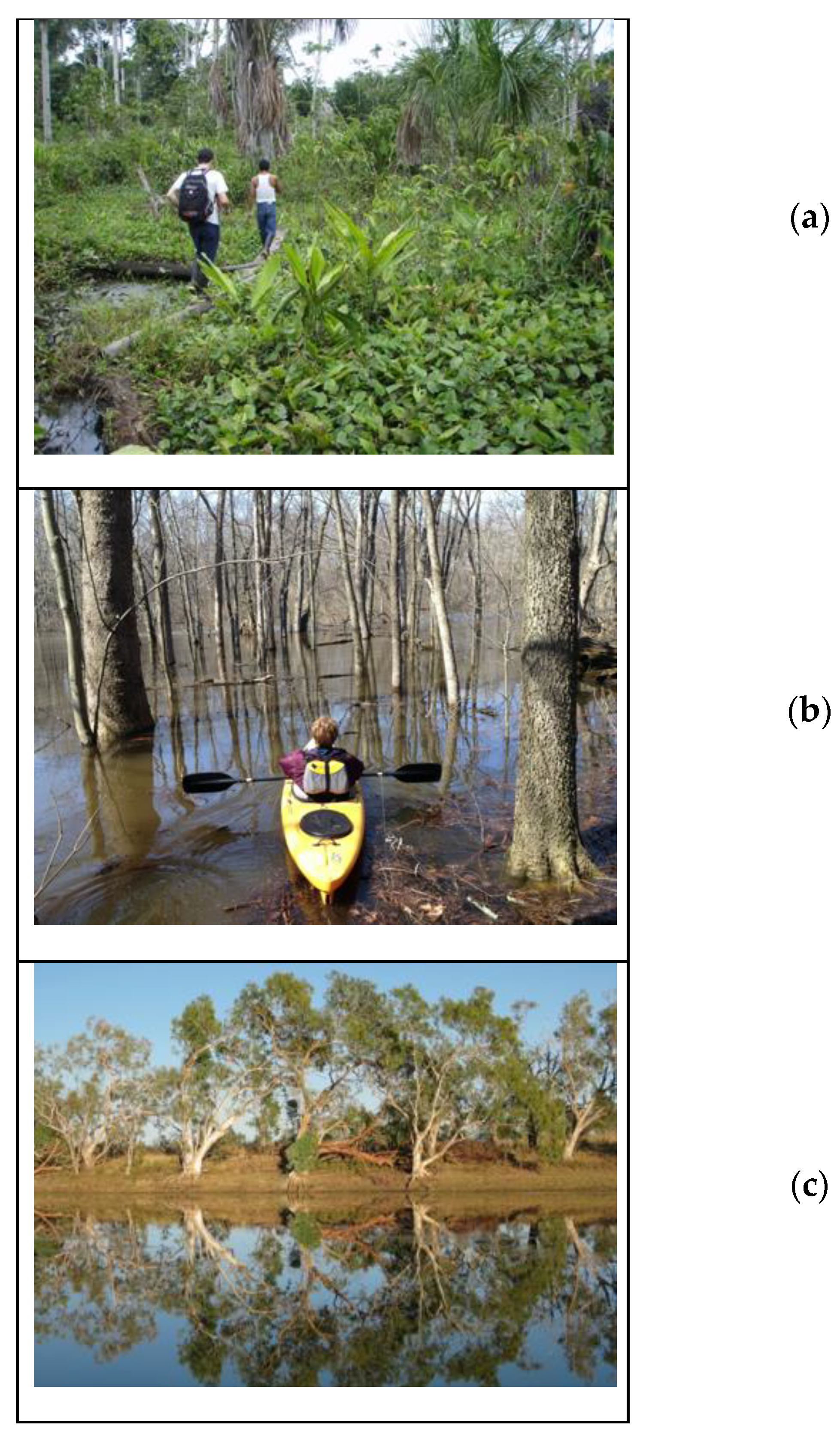
2.1. Study Areas
2.2. Measurements of Water Levels and Temperature
2.3. Interpretation of Temperature Data to Reveal Inundation
3. Results
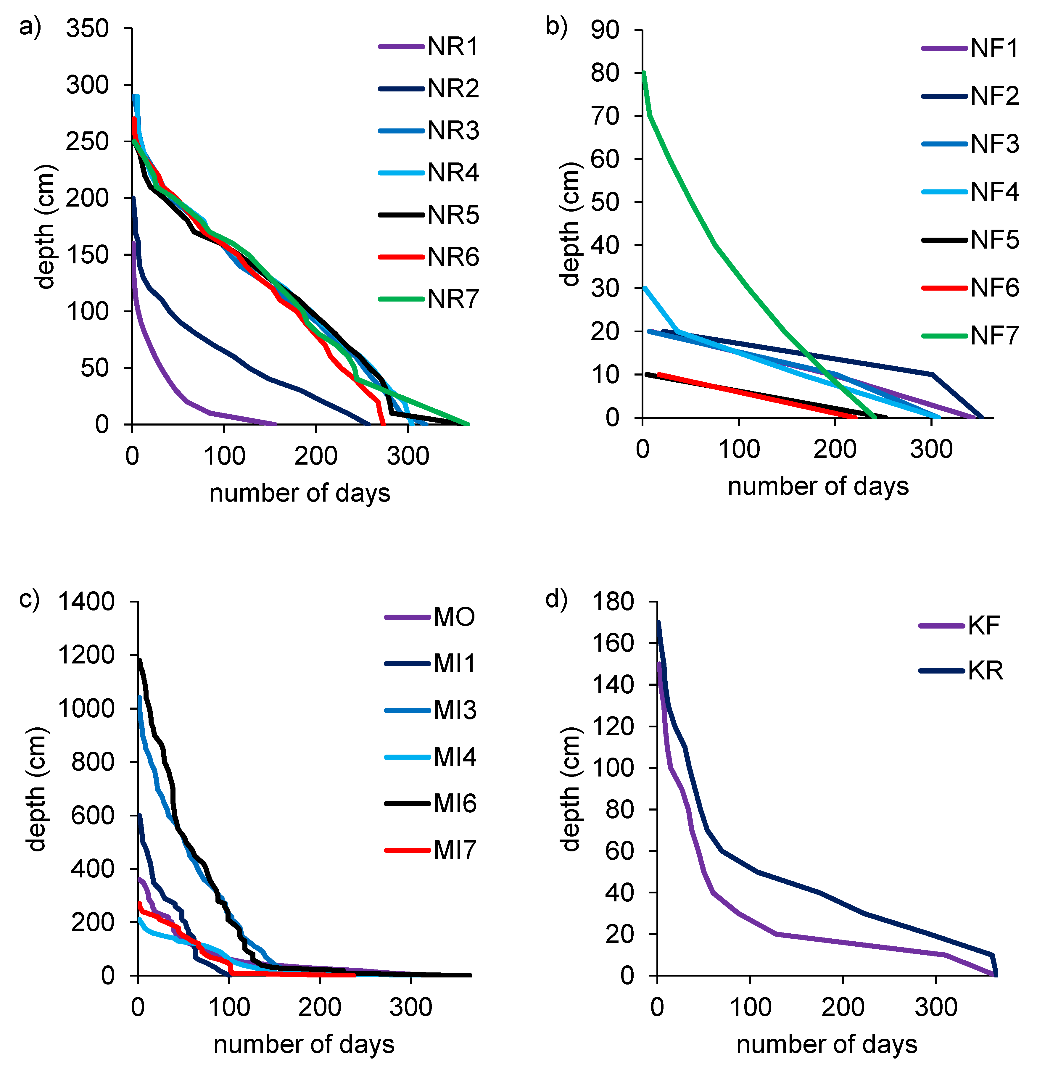
3.1. Inundation Patterns Based on Direct Measurements
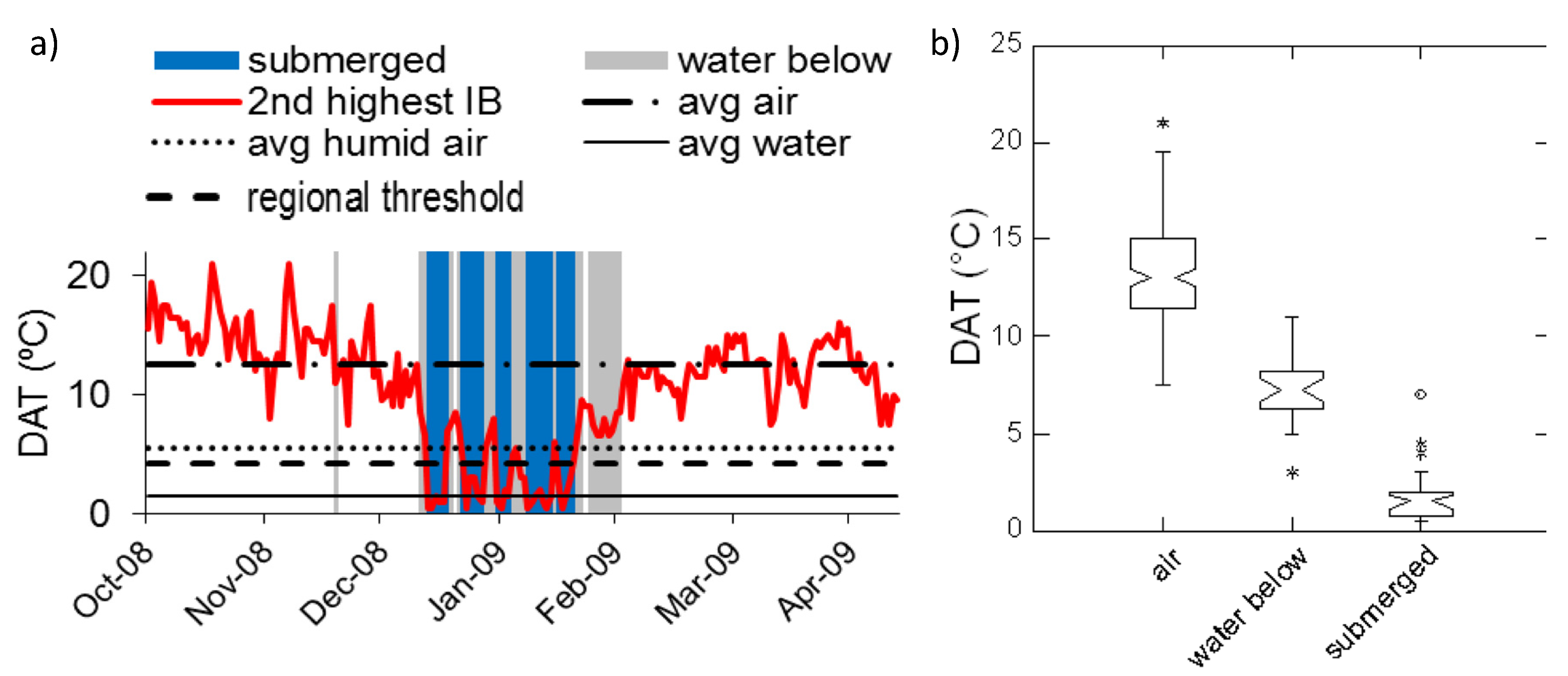
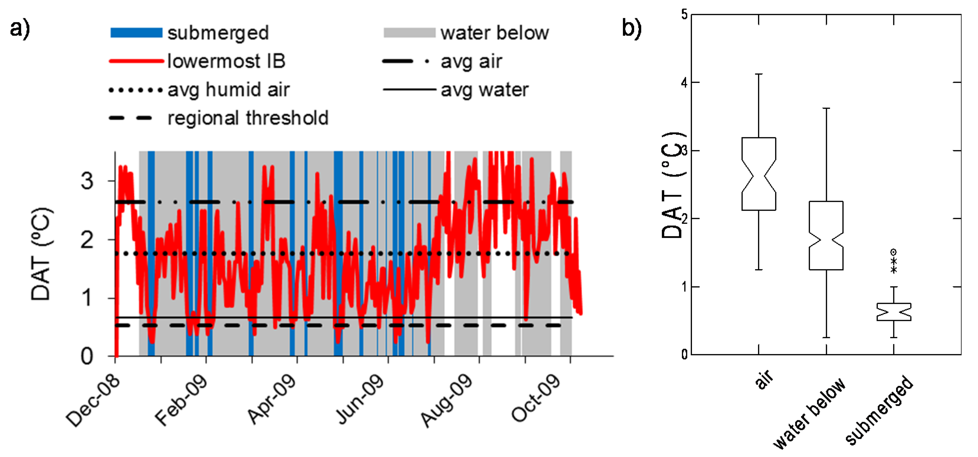
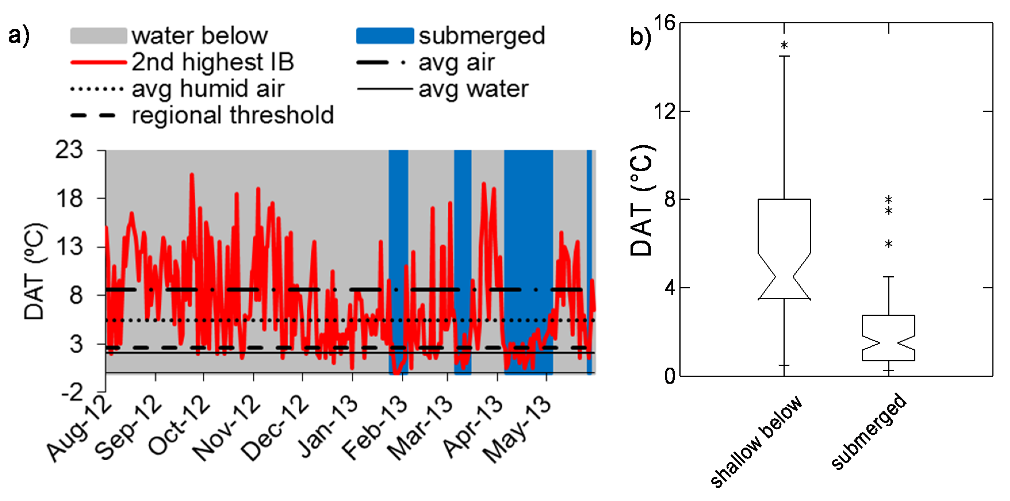
3.2. Relationship between DAT and Inundation
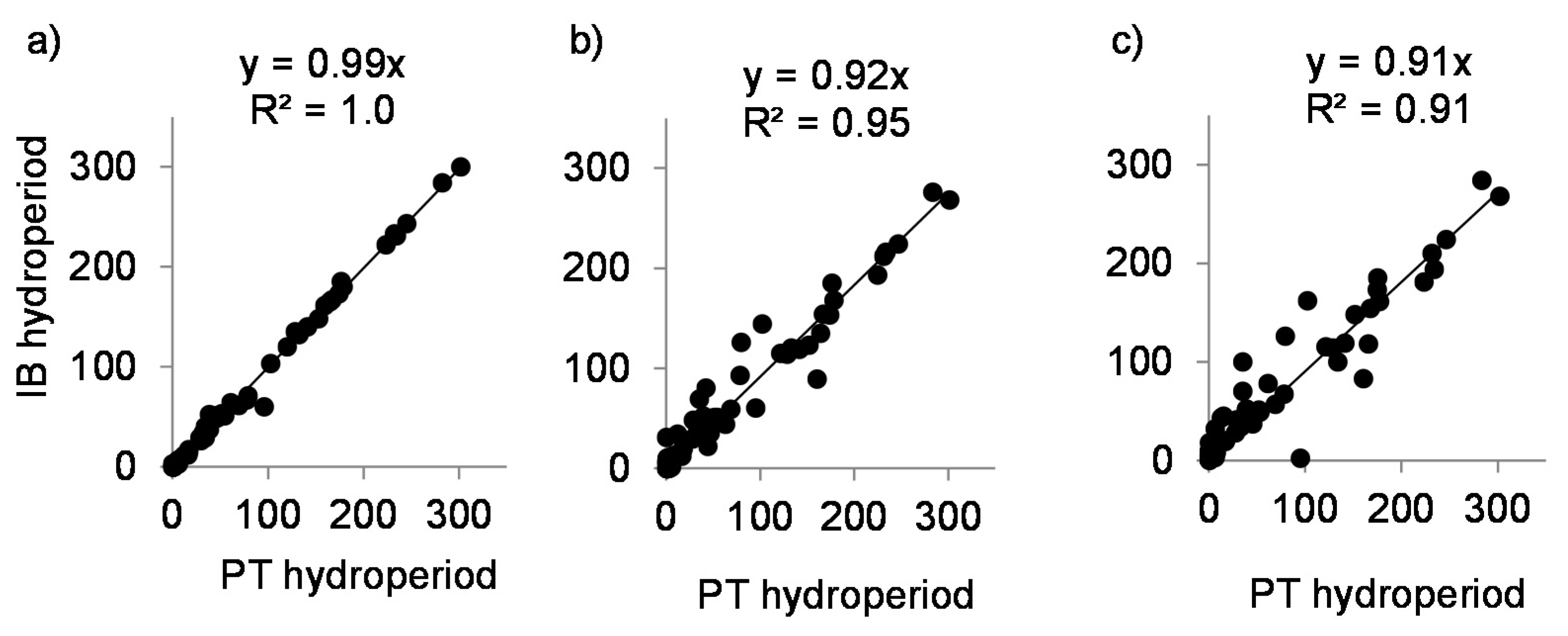
3.3. Temperature Thresholds and Hydroperiod Estimation
4. Discussion and Conclusions
Author Contributions
Funding
Acknowledgments
Conflicts of Interest
References
- Hamilton, S.K. Flood Plains. In Encyclopedia of Inland Waters; Likens, G.E., Ed.; Elsevier: Oxford, UK, 2009; Volume 3, pp. 378–386. Available online: http://www.sciencedirect.com/science/article/pii/B9780123706263000521 (accessed on 1 October 2020).
- Junk, W.J.; Bayley, P.B.; Sparks, R.E. The flood pulse concept in river-floodplain-systems. Can. Spec. Publ. Fish. Aquat. Sci. 1989, 106, 110–127. [Google Scholar]
- Junk, W.J.; Wantzen, K.M.; Nunes da Cunha, C.; da Silva, C.J. Ecology, biodiversity and sustainable management of the Pantanal: A synthesis. In The Pantanal of Mato Grosso: Ecology, Biodiversity and Sustainable Management of a Large Neotropical Seasonal Wetland; Pensoft: Sofia, Bulgaria, 2011. [Google Scholar]
- Lewis, J.W.M.; Hamilton, S.K.; Lasi, M.A.; Rodríguez, M.A.; Saunders, J.F. Ecological determinism on the Orinoco floodplain. BioScience 2000, 50, 681. [Google Scholar] [CrossRef] [Green Version]
- Conly, F.M.; Su, M.; Kamp, G.; Millar, J.J. A practical approach to monitoring water levels in Prairie wetlands. Wetlands 2004, 24, 219–226. [Google Scholar] [CrossRef]
- Greswell, R.; Ellis, P.; Cuthbert, M.O.; White, R.; Durand, V. The design and application of an inexpensive pressure monitoring system for shallow water level measurement, tensiometry and piezometry. J. Hydrol. 2009, 373, 416–425. [Google Scholar] [CrossRef]
- Danielsen, F.; Burgess, N.D.; Balmford, A.; Donald, P.F.; Funder, M.; Jones, J.P.G.; Alviola, P.; Balete, D.S.; Blomley, T.; Brashares, J.; et al. Local Participation in Natural Resource Monitoring: A Characterization of Approaches. Conserv. Biol. 2009, 23, 31–42. [Google Scholar] [CrossRef] [PubMed]
- Alsdorf, D.E.; Rodríguez, E.; Lettenmaier, D.P. Measuring surface water from space. Rev. Geophys. 2007, 45. [Google Scholar] [CrossRef]
- Melack, J.M.; Hess, L.L. Remote Sensing of the Distribution and Extent of Wetlands in the Amazon Basin. In Amazonian Floodplain Forests: Ecophysiology, Ecology, Biodiversity and Sustainable Management; Ecological Studies; Junk, W.J., Piedade, M., Wittmann, F., Schöngart, J., Parolin, P., Eds.; Springer: Berlin, Germany, 2010; pp. 43–59. [Google Scholar]
- Gennai, M.; Carnicelli, S.; Dell’Olmo, L.; Gabellini, A.; Giunti, M.; Lazzaro, L.; Lucchesi, F.; Monacci, F.; Viciani, D.; Foggi, B. The Floodplain Woods of Tuscany. J. Maps 2020, 16, 179–186. [Google Scholar] [CrossRef]
- Lee, H.; Beighley, R.E.; Alsdorf, D.; Jung, H.C.; Shum, C.; Duan, J.; Guo, J.; Yamazaki, D.; Andreadis, K. Characterization of terrestrial water dynamics in the Congo Basin using GRACE and satellite radar altimetry. Remote Sens. Environ. 2011, 115, 3530–3538. [Google Scholar] [CrossRef] [Green Version]
- Ward, D.P.; Hamilton, S.K.; Jardine, T.D.; Pettit, N.E.; Tews, E.K.; Olley, J.M.; Bunn, S.E. Assessing the seasonal dynamics of inundation, turbidity, and aquatic vegetation in the Australian wet-dry tropics using optical remote sensing. Ecohydrology 2012, 6, 312–323. [Google Scholar] [CrossRef] [Green Version]
- Alsdorf, D.; Birkett, C.; Dunne, T.; Melack, J.; Hess, L. Water level changes in a large Amazon lake measured with spaceborne radar interferometry and altimetry. Geophys. Res. Lett. 2001, 28, 2671–2674. [Google Scholar] [CrossRef]
- Jung, H.C.; Hamski, J.; Durand, M.T.; Alsdorf, D.; Hossain, F.; Lee, H.; Hossain, A.K.M.A.; Hasan, K.; Khan, A.S.; Hoque, A.Z. Characterization of complex fluvial systems using remote sensing of spatial and temporal water level variations in the Amazon, Congo, and Brahmaputra Rivers. Earth Surf. Process. Landf. 2010, 35, 294–304. [Google Scholar] [CrossRef]
- Poncos, V.; Teleaga, D.; Bondar, C.; Oaie, G. A new insight on the water level dynamics of the Danube Delta using a high spatial density of SAR measurements. J. Hydrol. 2013, 482, 79–91. [Google Scholar] [CrossRef]
- Costache, R.; Popa, M.C.; Tien Bui, D.; Diaconu, D.C.; Ciubotaru, N.; Minea, G.; Pham, Q.B. Spatial predicting of flood potential areas using novel hybridizations of fuzzy decision-making, bivariate statistics, and machine learning. J. Hydrol. 2020, 585. [Google Scholar] [CrossRef]
- Pettit, N.E.; Jardine, T.D.; Hamilton, S.K.; Sinnamon, V.; Valdez, D.; Davies, P.M.; Douglas, M.M.; Bunn, S.E. Seasonal changes in water quality and macrophytes and the impact of cattle on tropical floodplain waterholes. Mar. Freshw. Res. 2012, 63, 788–800. [Google Scholar] [CrossRef] [Green Version]
- Nezval, O.; Krejza, J.; Světlík, J.; Šigut, L.; Horáček, P. Comparison of traditional ground-based observations and digital remote sensing of phenological transitions in a floodplain forest. Agric. For. Meteorol. 2020, 291, 108079. [Google Scholar] [CrossRef]
- Chapin, T.P.; Todd, A.S.; Zeigler, M.P. Robust, low-cost data loggers for stream temperature, flow intermittency, and relative conductivity monitoring. Water Resour. Res. 2014, 50, 6542–6548. [Google Scholar] [CrossRef]
- Hubbart, J.; Link, T.; Campbell, C.; Cobos, D. Evaluation of a low-cost temperature measurement system for environmental applications. Hydrol. Process. 2005, 19, 1517–1523. [Google Scholar] [CrossRef]


| River System | Region | Latitude/Longitude Range | Biome | Climate | No. of Sites | Study Period |
|---|---|---|---|---|---|---|
| Mitchell | Northern Australia | 15.35–16.71° S/141.72–143.41° E | Wet–dry savanna | Dry tropical | 5 | 8 October–9 May |
| Moonie | Eastern Australia | 28.93° S/148.74° E | Wet–dry savanna | Dry subtropical | 1 | 7 October–8 April |
| Napo | Western Amazon | 0.73–3.03° S/75.69–73.15° W | Rainforest | Humid tropical | 14 | 8 December–9 December |
| Kalamazoo | Michigan | 42.32° N/85.36° W | Deciduous forest | Temperate | 2 | 12 August–13 June |
| Threshold (°C) | Discrepancy (Days) | |||
|---|---|---|---|---|
| Location | Sensor Specific | Mean of all Sites | Site | Regional |
| Napo floodplains | 0.50–1.90 | 0.67 ± 0.35 | 4.29 ± 4.14 (r2 = 0.09, p < 0.00) | 12.88 ± 10.66 (r2 = 0.41, p = 0.04) |
| Napo River | 0.50–2.10 | 1.01 ± 0.35 | 11.08 ± 8.04 (r2 = 0.99, p < 0.00) | 12.16 ± 8.47 (r2 = 0.99, p < 0.00) |
| Mitchell River | 1.90–9.00 | 4.21 ± 1.38 | 9.97 ± 12.26 (r2 = 0.98, p < 0.00) | 10.37 ± 12.16 (r2 = 0.88, p < 0.00) |
| Moonie River | 2.60–7.60 | 5.93 | 13.33 (r2 = 0.99, p = 0.05) | --b |
| Kalamazoo River & floodplain | 1.50–5.00 | 2.56 ± 0.65 | 24.75 ± 6.01 (r2 = 0.98, p < 0.00) | 26.10 ± 4.38 c (r2 = 0.97, p < 0.00) |
| All sites | 0.50–9.00 | 2.00 ± 1.79 | 10.29 ± 9.38 (r2 = 0.92, p < 0.00) | 13.32 ± 9.97 (r2 = 0.91, p < 0.00) |
Publisher’s Note: MDPI stays neutral with regard to jurisdictional claims in published maps and institutional affiliations. |
© 2020 by the authors. Licensee MDPI, Basel, Switzerland. This article is an open access article distributed under the terms and conditions of the Creative Commons Attribution (CC BY) license (http://creativecommons.org/licenses/by/4.0/).
Share and Cite
Celi, J.E.; Hamilton, S.K. Measuring Floodplain Inundation Using Diel Amplitude of Temperature. Sensors 2020, 20, 6189. https://doi.org/10.3390/s20216189
Celi JE, Hamilton SK. Measuring Floodplain Inundation Using Diel Amplitude of Temperature. Sensors. 2020; 20(21):6189. https://doi.org/10.3390/s20216189
Chicago/Turabian StyleCeli, Jorge E., and Stephen K. Hamilton. 2020. "Measuring Floodplain Inundation Using Diel Amplitude of Temperature" Sensors 20, no. 21: 6189. https://doi.org/10.3390/s20216189
APA StyleCeli, J. E., & Hamilton, S. K. (2020). Measuring Floodplain Inundation Using Diel Amplitude of Temperature. Sensors, 20(21), 6189. https://doi.org/10.3390/s20216189