
The Impacts of Burn Severity and Frequency on Erosion in Western Arnhem Land, Australia

 ,
,  and
and 
Abstract
:1. Introduction
2. Materials and Methods
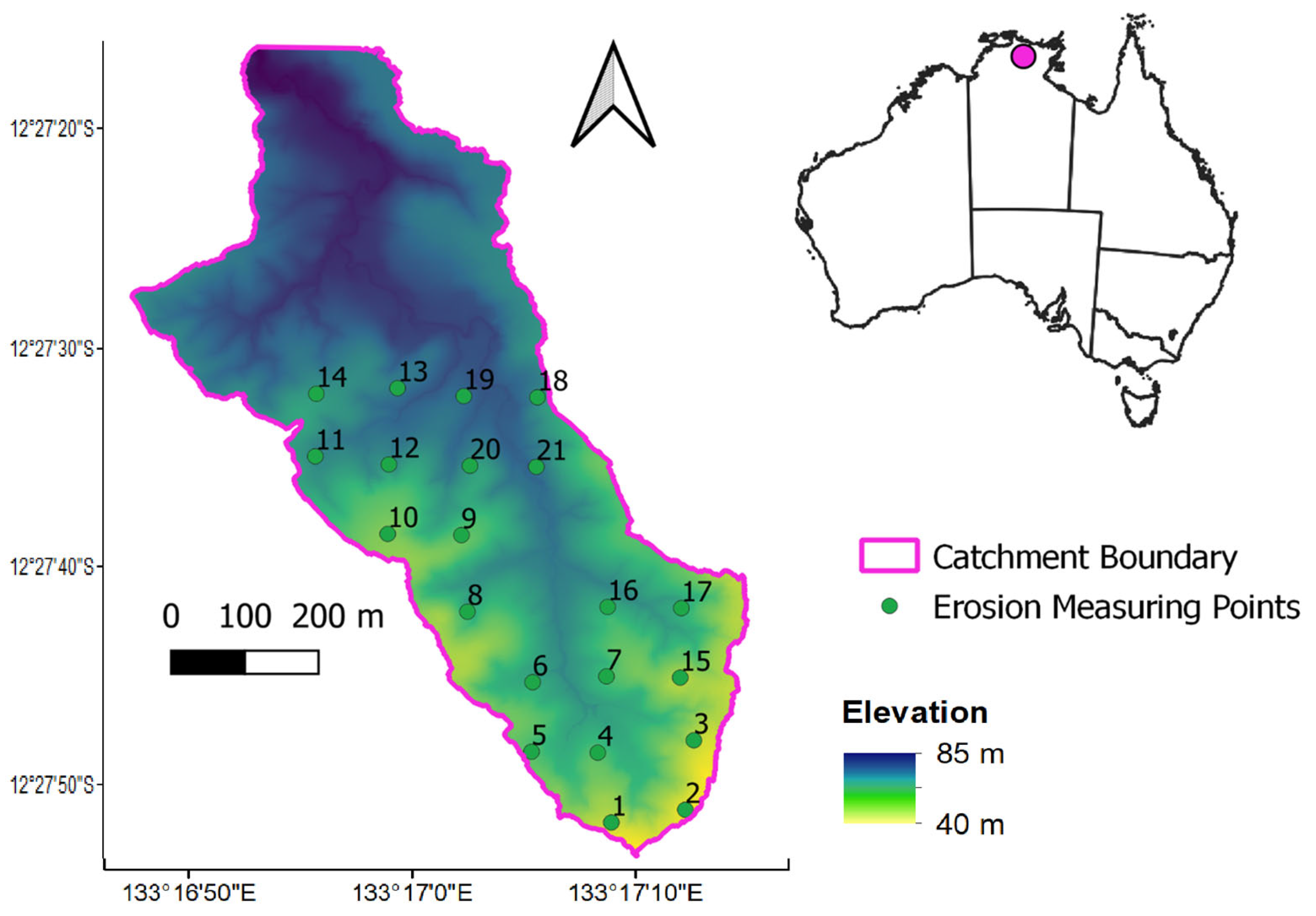
2.1. Site Description
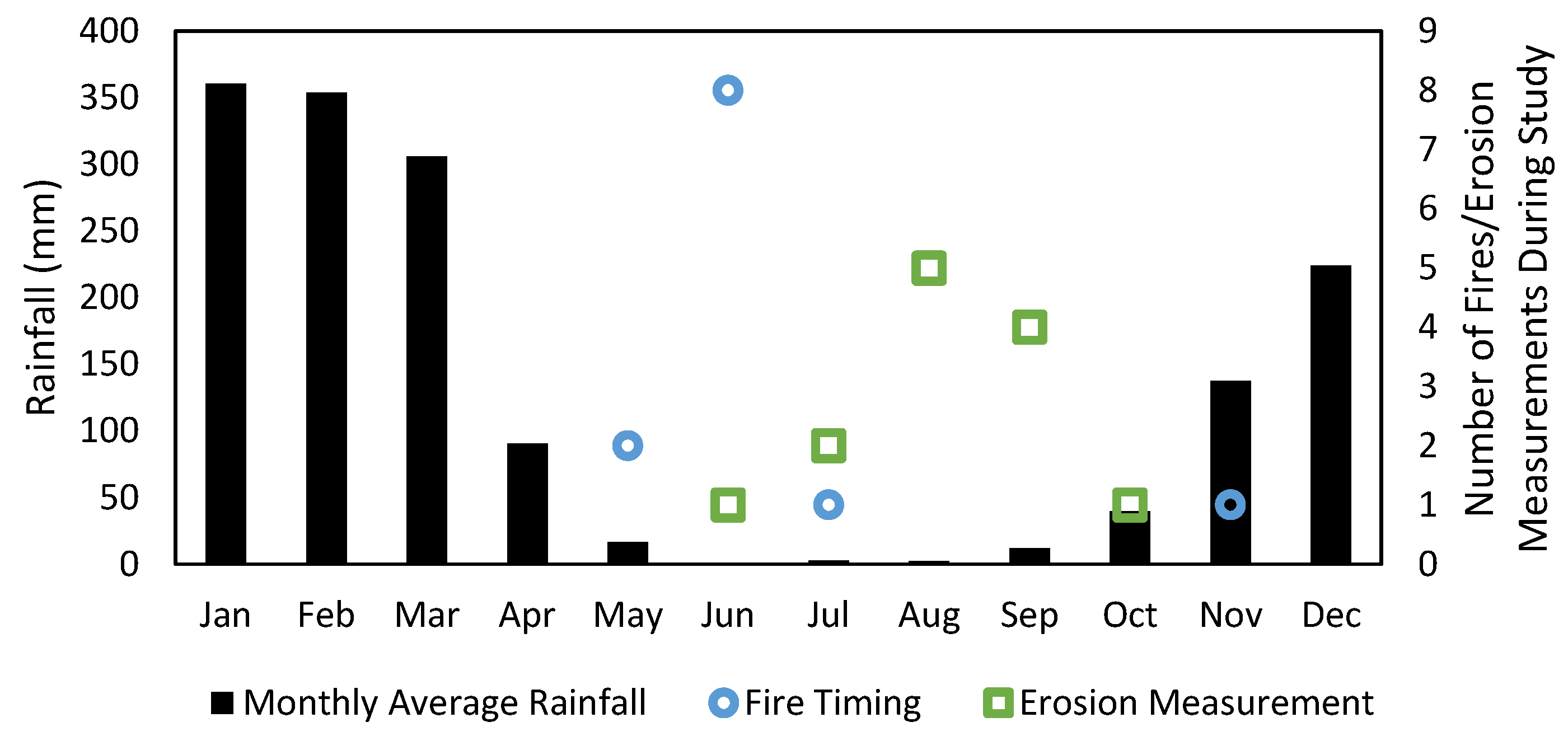
2.2. Fire Regime
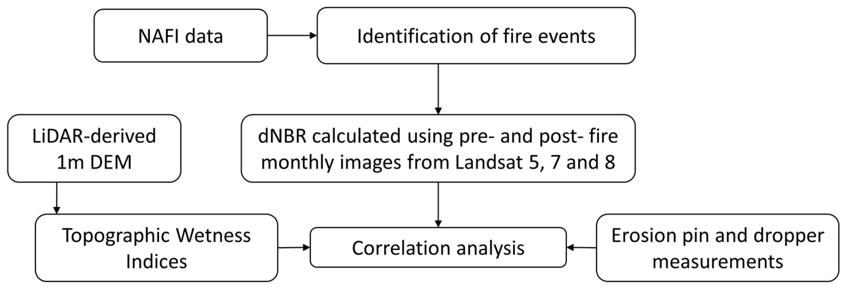
2.3. Data
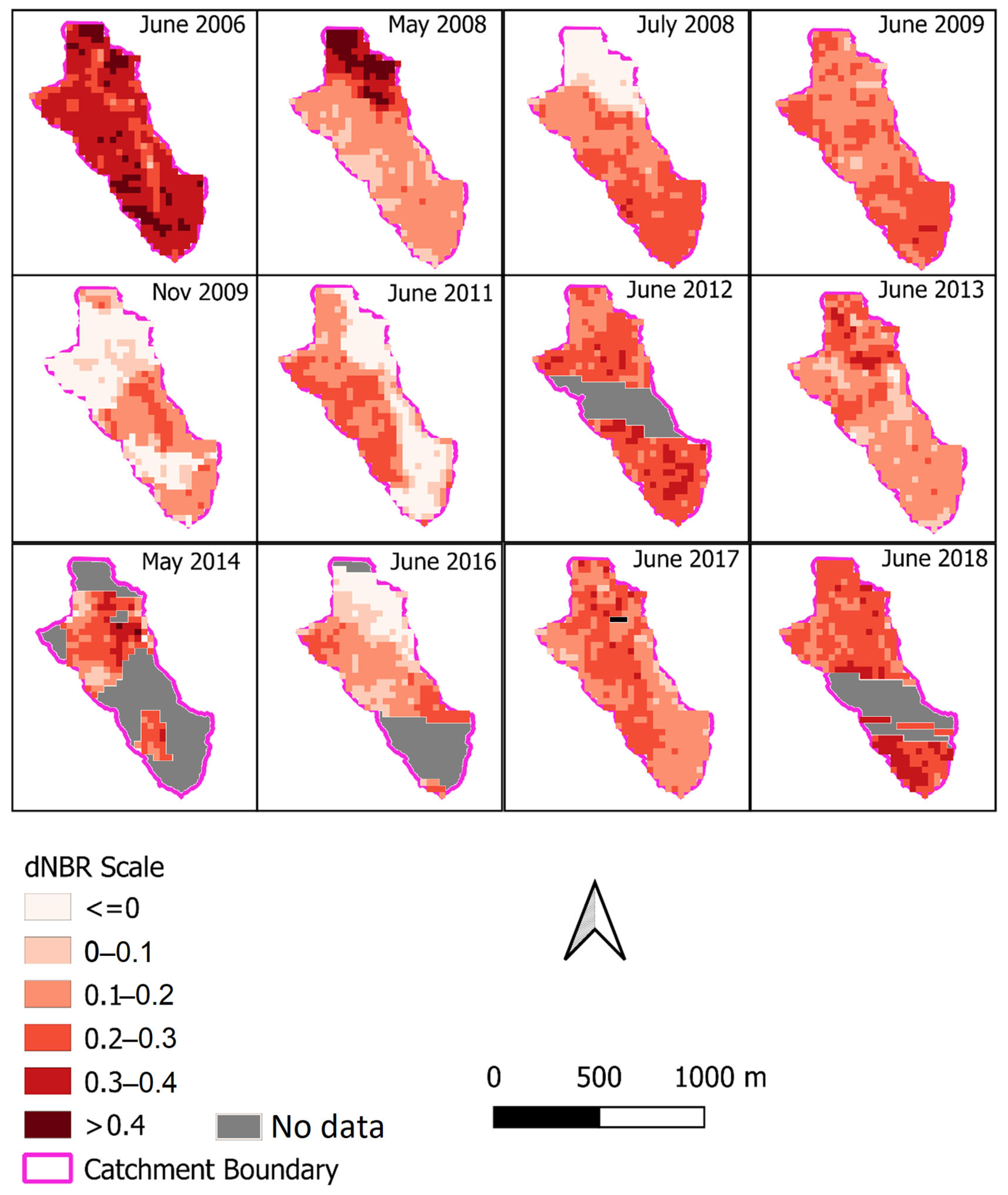
2.3.1. Remote Sensing Data
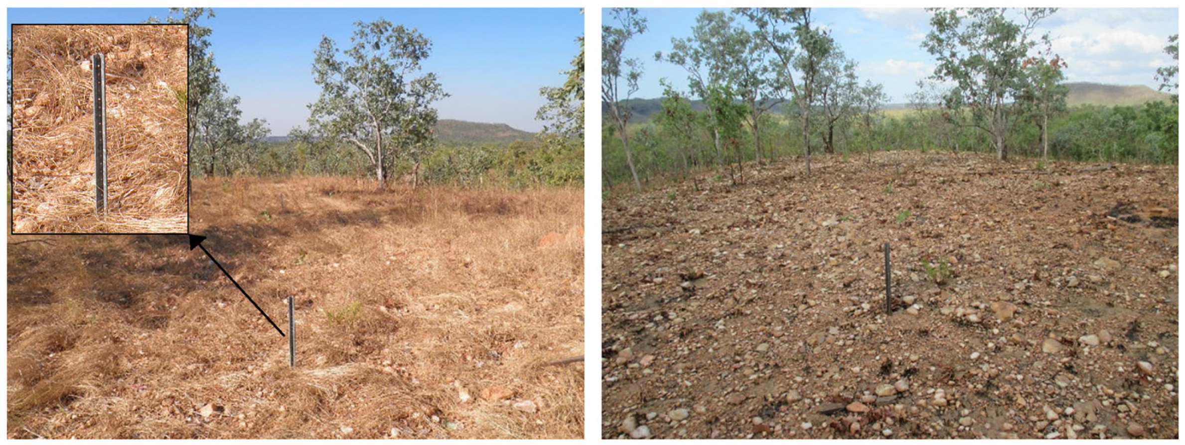
2.3.2. In Situ Erosion Measurements
2.4. Methodology
3. Results
4. Discussion
4.1. dNBR and Surface Erosion
4.2. Environmental Implications and Fire Frequency
4.3. Remote Sensing and Future Considerations
5. Conclusions
Supplementary Materials
Author Contributions
Funding
Data Availability Statement
Acknowledgments
Conflicts of Interest
References
- Earl, N.; Simmonds, I. Spatial and Temporal Variability and Trends in 2001–2016 Global Fire Activity. J. Geophys. Res. Atmos. 2018, 123, 2524–2536. [Google Scholar] [CrossRef]
- Hill, R.S.; Jordan, G.J. Deep history of wildfire in Australia. Aust. J. Bot. 2016, 64, 557–563. [Google Scholar] [CrossRef]
- Peters, M.P.; Iverson, L.R.; Matthews, S.N.; Prasad, A.M. Wildfire hazard mapping: Exploring site conditions in eastern US wildland–urban interfaces. Int. J. Wildland Fire 2013, 22, 567–578. [Google Scholar] [CrossRef]
- Fernandes, P.M.; Botelho, H.S. A review of prescribed burning effectiveness in fire hazard reduction. Int. J. Wildland Fire 2003, 12, 117–128. [Google Scholar] [CrossRef]
- Peters, M.P.; Iverson, L.R. Incorporating fine-scale drought information into an eastern US wildfire hazard model. Int. J. Wildland Fire 2017, 26, 393. [Google Scholar] [CrossRef]
- Shrestha, A.; Grala, R.K.; Grado, S.C.; Roberts, S.D.; Gordon, J.S. Landowner Concern about Wildfires and Implementation of Fuel Reduction Treatments. J. For. 2021, 119, 251–265. [Google Scholar] [CrossRef]
- van der Werf, G.R.; Randerson, J.T.; Giglio, L.; van Leeuwen, T.T.; Chen, Y.; Rogers, B.M.; Mu, M.; van Marle, M.J.E.; Morton, D.C.; Collatz, G.J.; et al. Global fire emissions estimates during 1997–2016. Earth Syst. Sci. Data 2017, 9, 697–720. [Google Scholar] [CrossRef]
- Keeley, J.E. Fire intensity, fire severity and burn severity: A brief review and suggested usage. Int. J. Wildland Fire 2009, 18, 116–126. [Google Scholar] [CrossRef]
- Atkinson, G. Soil Erosion Following Wildfire in Royal National Park, NSW. Proc. Linn. Soc. N. S. Wales 2012, 134, B25–B38. [Google Scholar]
- Yang, X.; Zhu, Q.; Tulau, M.; McInnes-Clarke, S.; Sun, L.; Zhang, X. Near real-time monitoring of post-fire erosion after storm events: A case study in Warrumbungle National Park, Australia. Int. J. Wildland Fire 2018, 27, 413–424. [Google Scholar] [CrossRef]
- Smith, H.G.; Dragovich, D. Post-fire hillslope erosion response in a sub-alpine environment, south-eastern Australia. Catena 2008, 73, 274–285. [Google Scholar] [CrossRef]
- Cawson, J.G.; Sheridan, G.J.; Smith, H.G.; Lane, P.N.J. Surface runoff and erosion after prescribed burning and the effect of different fire regimes in forests and shrublands: A review. Int. J. Wildland Fire 2012, 21, 857–872. [Google Scholar] [CrossRef]
- Shakesby, R.A.; Wallbrink, P.J.; Doerr, S.H.; English, P.M.; Chafer, C.J.; Humphreys, G.S.; Blake, W.H.; Tomkins, K.M. Distinctiveness of wildfire effects on soil erosion in south-east Australian eucalypt forests assessed in a global context. For. Ecol. Manag. 2007, 238, 347–364. [Google Scholar] [CrossRef]
- Parsons, A.; Robichaud, P.R.; Lewis, S.A.; Napper, C.; Clark, J.T. Field Guide for Mapping Post-Fire Soil Burn Severity; United States Department of Agriculture: Fort Collins, CO, USA, 2010. [CrossRef]
- Chiang, S.-H.; Ulloa, N.I. Mapping and tracking forest burnt areas in the indio maiz biological reserve using sentinel-3 SLSTR and VIIRS-DNB imagery. Sensors 2019, 19, 5423. [Google Scholar] [CrossRef] [PubMed]
- García, M.J.L.; Caselles, V. Mapping burns and natural reforestation using thematic mapper data. Geocarto Int. 1991, 6, 31–37. [Google Scholar] [CrossRef]
- Christopoulou, A.; Mallinis, G.; Vassilakis, E.; Farangitakis, G.P.; Fyllas, N.M.; Kokkoris, G.D.; Arianoutsou, M. Assessing the impact of different landscape features on post-fire forest recovery with multitemporal remote sensing data: The case of Mount Taygetos (southern Greece). Int. J. Wildland Fire 2019, 28, 521–532. [Google Scholar] [CrossRef]
- Li, L.; Xin, X.; Zhao, J.; Yang, A.; Wu, S.; Zhang, H.; Yu, S. Remote Sensing Monitoring and Assessment of Global Vegetation Status and Changes during 2016–2020. Sensors 2023, 23, 8452. [Google Scholar] [CrossRef]
- Andela, N.; Morton, D.C.; Giglio, L.; Paugam, R.; Chen, Y.; Hantson, S.; van der Werf, G.R.; Randerson, J.T. The Global Fire Atlas of individual fire size, duration, speed and direction. Earth Syst. Sci. Data 2019, 11, 529–552. [Google Scholar] [CrossRef]
- Sánchez Sánchez, Y.; Martínez Graña, A.; Santos-Francés, F. Remote Sensing Calculation of the Influence of Wildfire on Erosion in High Mountain Areas. Agronomy 2021, 11, 1459. [Google Scholar] [CrossRef]
- Efthimiou, N.; Psomiadis, E.; Panagos, P. Fire severity and soil erosion susceptibility mapping using multi-temporal Earth Observation data: The case of Mati fatal wildfire in Eastern Attica, Greece. Catena 2020, 187, 104320. [Google Scholar] [CrossRef]
- Argentiero, I.; Ricci, G.F.; Elia, M.; D’Este, M.; Giannico, V.; Ronco, F.V.; Gentile, F.; Sanesi, G. Combining methods to estimate post-fire soil erosion using remote sensing data. Forests 2021, 12, 1105. [Google Scholar] [CrossRef]
- Mallinis, G.; Maris, F.; Kalinderis, I.; Koutsias, N. Assessment of post-fire soil erosion risk in fire-affected watersheds using remote sensing and GIS. GIScience Remote Sens. 2009, 46, 388–410. [Google Scholar] [CrossRef]
- Pérez-Cabello, F.; Montorio, R.; Alves, D.B. Remote sensing techniques to assess post-fire vegetation recovery. Curr. Opin. Environ. Sci. Health 2021, 21, 100251. [Google Scholar] [CrossRef]
- Baghbani, A.; Choudhury, T.; Costa, S.; Reiner, J. Application of artificial intelligence in geotechnical engineering: A state-of-the-art review. Earth-Sci. Rev. 2022, 228, 103991. [Google Scholar] [CrossRef]
- Howe, A.A.; Parks, S.A.; Harvey, B.J.; Saberi, S.J.; Lutz, J.A.; Yocom, L.L. Comparing Sentinel-2 and Landsat 8 for burn severity mapping in Western North America. Remote Sens. 2022, 14, 5249. [Google Scholar] [CrossRef]
- Kurbanov, E.; Vorobev, O.; Lezhnin, S.; Sha, J.; Wang, J.; Li, X.; Cole, J.; Dergunov, D.; Wang, Y. Remote sensing of forest burnt area, burn severity, and post-fire recovery: A review. Remote Sens. 2022, 14, 4714. [Google Scholar] [CrossRef]
- Russell-Smith, J.; Edwards, A.C.; Sangha, K.K.; Yates, C.P.; Gardener, M.R. Challenges for prescribed fire management in Australia’s fire-prone rangelands–the example of the Northern Territory. Int. J. Wildland Fire 2020, 29, 339–353. [Google Scholar] [CrossRef]
- Hernandez-Santin, L.; Erskine, P.D.; Bartolo, R.E. A review of revegetation at mine sites in the Alligator Rivers Region, Northern Territory, and the development of a state and transition model for ecological restoration at Ranger uranium mine. J. Clean. Prod. 2020, 246, 119079. [Google Scholar] [CrossRef]
- Andersen, A.N.; Braithwaite, R.W.; Cook, G.D.; Corbett, L.K.; Williams, R.J.; Douglas, M.M.; Gill, A.M.; Setterfield, S.A.; Muller, W.J. Fire research for conservation management in tropical savannas: Introducing the Kapalga fire experiment. Aust. J. Ecol. 1998, 23, 95–110. [Google Scholar] [CrossRef]
- Werner, P.A.; Peacock, S.J. Savanna canopy trees under fire: Long-term persistence and transient dynamics from a stage-based matrix population model. Ecosphere 2019, 10, 1–41. [Google Scholar] [CrossRef]
- Hancock, G.; Lowry, J.; Dever, C.; Braggins, M. Does introduced fauna influence soil erosion? A field and modelling assessment. Sci. Total Environ. 2015, 518, 189–200. [Google Scholar] [CrossRef]
- Hancock, G.R.; Lowry, J.B.C. Hillslope erosion measurement-a simple approach to a complex process. Hydrol. Process. 2015, 29, 4809–4816. [Google Scholar] [CrossRef]
- Hancock, G.R.; Lowry, J.B.C.; Dever, C. Surface Disturbance and Erosion by Pigs: A Medium Term Assessment for the Monsoonal Tropics. Land Degrad. Dev. 2016, 28, 255–264. [Google Scholar] [CrossRef]
- Uren, C. An Investigation of Surface Geology in the Alligator Rivers Region for Possible Analogues of Uranium Mine Rehabilitation Structures; Internal Report 56; Supervising Scientist for the Alligator Rivers Region: Canberra, Australia, 1992.
- Story, R.; Galloway, R.W.; McAlpine, J.R.; Aldrick, J.M.; Williams, M.A.J. Lands of the Alligator Rivers Area, Northern Territory; Land Research Series No. 38; CSIRO: Melbourne, Australia, 1976.
- Saynor, M.J.; Erskine, W.D.; Evans, K.G.; Eliot, I. Gully initiation and implications for management of scour holes in the vicinity of the Jabiluka Mine, Northern Territory, Australia. Geogr. Ann. 2004, 86, 191–203. [Google Scholar] [CrossRef]
- Heimsath, A.M.; Fink, D.; Hancock, G.R. The ‘humped’soil production function: Eroding Arnhem Land, Australia. Earth Surf. Process. Landf. 2009, 34, 1674–1684. [Google Scholar] [CrossRef]
- Russell-Smith, J.; Ryan, P.G.; Durieu, R. A LANDSAT MSS-Derived Fire History of Kakadu National Park, Monsoonal Northern Australia, 1980-94: Seasonal Extent, Frequency and Patchiness. J. Appl. Ecol. 1997, 34, 748–766. [Google Scholar] [CrossRef]
- Bonta, M.; Gosford, R.; Eussen, D.; Gerguson, N.; Loveless, E.; Witwer, M. Intentional Fire-Spreading by “Firehawk” Raptors in Northern Australia. J. Ethnobiol. 2017, 37, 700–718. [Google Scholar] [CrossRef]
- Harris, S.; Tapper, N.; Packham, D.; Orlove, B.; Nicholls, N. The relationship between the monsoonal summer rain and dry-season fire activity of northern Australia. Int. J. Wildland Fire 2008, 17, 674–684. [Google Scholar] [CrossRef]
- Setterfield, S.A.; Rossiter-Rachor, N.A.; Douglas, M.M.; McMaster, D.; Adams, V.; Ferdinands, K. The impacts of Andropogon gayanus (gamba grass) invasion on the fire danger index and fire management at a landscape scale. In Proceedings of the Nineteenth Australasian Weeds Conference, Hobart, TAS, Australia, 1–4 September 2014; pp. 125–128. [Google Scholar]
- Setterfield, S.A.; Rossiter-Rachor, N.A.; Douglas, M.M.; Wainger, L.; Petty, A.M.; Barrow, P.; Shepherd, I.J.; Ferdinands, K.B. Adding fuel to the fire: The impacts of non-native grass invasion on fire management at a regional scale. PLoS ONE 2013, 8, e59144. [Google Scholar] [CrossRef] [PubMed]
- Setterfield, S.A.; Rossiter-Rachor, N.A.; Hutley, L.B.; Douglas, M.M.; Williams, R.J. Biodiversity Research: Turning up the heat: The impacts of Andropogon gayanus (gamba grass) invasion on fire behaviour in northern Australian savannas. Divers. Distrib. 2010, 16, 854–861. [Google Scholar] [CrossRef]
- Dhu, T.; Dunn, B.; Lewis, B.; Lymburner, L.; Mueller, N.; Telfer, E.; Lewis, A.; McIntyre, A.; Minchin, S.; Phillips, C. Digital earth Australia–unlocking new value from earth observation data. Big Earth Data 2017, 1, 64–74. [Google Scholar] [CrossRef]
- Tarboton, D.G. A new method for the determination of flow directions and upslope areas in grid digital elevation models. Water Resour. Res. 1997, 33, 309–319. [Google Scholar] [CrossRef]
- Conrad, O.; Bechtel, B.; Bock, M.; Dietrich, H.; Fischer, E.; Gerlitz, L.; Wehberg, J.; Wichmann, V.; Böhner, J. System for Automated Geoscientific Analyses (SAGA) v. 2.1.4. Geosci. Model Dev. 2015, 8, 1991–2007. [Google Scholar] [CrossRef]
- Bretreger, D.; Yeo, I.Y.; Melchers, R. Terrain wetness indices derived from LiDAR to inform soil moisture and corrosion potential for underground infrastructure. Sci Total Environ. 2021, 756, 144138. [Google Scholar] [CrossRef]
- Loughran, R.J. The measurement of soil erosion. Prog. Phys. Geogr. 1989, 13, 216–233. [Google Scholar] [CrossRef]
- Flood, N. Continuity of Reflectance Data between Landsat-7 ETM+ and Landsat-8 OLI, for Both Top-of-Atmosphere and Surface Reflectance: A Study in the Australian Landscape. Remote Sens. 2014, 6, 7952–7970. [Google Scholar] [CrossRef]
- Key, C.H.; Benson, N. Landscape Assessment (LA) Sampling and Analysis Methods; United States Department of Agriculture: Fort Collins, CO, USA, 2006.
- Hancock, G.; Loughran, R.; Evans, K.; Balog, R. Estimation of soil erosion using field and modelling approaches in an undisturbed Arnhem Land catchment, Northern Territory, Australia. Geogr. Res. 2008, 46, 333–349. [Google Scholar] [CrossRef]
- Wasson, R.; Saynor, M.; Lowry, J. The natural denudation rate of the lowlands near the Ranger mine, Australia: A target for mine site rehabilitation. Geomorphology 2021, 389, 107823. [Google Scholar] [CrossRef]
- Rahman, S.; Chang, H.-C.; Hehir, W.; Magil, C.; Tomkins, K. Inter-Comparison of Fire Severity Indices from Moderate (Modis) and Moderate-To-High Spatial Resolution (Landsat 8 & Sentinel-2A) Satellite Sensors. In Proceedings of the IGARSS 2018—2018 IEEE International Geoscience and Remote Sensing Symposium, Valencia, Spain, 22–27 July 2018. [Google Scholar]
- Atkinson, G. Erosion Damage Following Bushfires. J. Soil Conserv. 1984, 40, 4–9. [Google Scholar]
- White, I.; Wade, A.; Worthy, M.; Mueller, N.; Daniell, T.; Wasson, R. The vulnerability of water supply catchments to bushfires: Impacts of the January 2003 wildfires on the Australian Capital Territory. Australas. J. Water Resour. 2006, 10, 179–194. [Google Scholar] [CrossRef]
- Tomkins, K.M.; Humphreys, G.S.; Wilkinson, M.T.; Fink, D.; Hesse, P.P.; Doerr, S.H.; Shakesby, R.A.; Wallbrink, P.J.; Blake, W.H. Contemporary versus long-term denudation along a passive plate margin: The role of extreme events. Earth Surf. Process. Landf. 2007, 32, 1013–1031. [Google Scholar] [CrossRef]
- Shtober-Zisu, N.; Wittenberg, L. Long-term effects of wildfire on rock weathering and soil stoniness in the Mediterranean landscapes. Sci. Total Environ. 2021, 762, 143125. [Google Scholar] [CrossRef] [PubMed]
- Hancock, G.; Evans, K.G.; McDonnell, J.; Hopp, L. Ecohydrological controls on soil erosion and landscape evolution. Ecohydrology 2012, 5, 478–490. [Google Scholar] [CrossRef]
- Hancock, G.; Lowry, J. Quantifying the influence of rainfall, vegetation and animals on soil erosion and hillslope connectivity in the monsoonal tropics of northern Australia. Earth Surf. Process. Landf. 2021, 46, 2110–2123. [Google Scholar] [CrossRef]
- Arkle, R.S.; Pilliod, D.S. Prescribed fires as ecological surrogates for wildfires: A stream and riparian perspective. For. Ecol. Manag. 2010, 259, 893–903. [Google Scholar] [CrossRef]
- Galang, M.A.; Morris, L.A.; Markewitz, D.; Jackson, C.R.; Carter, E.A. Prescribed burning effects on the hydrologic behavior of gullies in the South Carolina Piedmont. For. Ecol. Manag. 2010, 259, 1959–1970. [Google Scholar] [CrossRef]
- Richter, D.; Ralston, C.; Harms, W. Prescribed fire: Effects on water quality and forest nutrient cycling. Science 1982, 215, 661–663. [Google Scholar] [CrossRef]
- Elliot, K.J.; Vose, J.M. Initial effects of prescribed fire on quality of soil solution and stream water in the southern Appalachian Mountains. South. J. Appl. For. 2005, 29, 5–15. [Google Scholar] [CrossRef]
- Gill, A.M.; Moore, P.H.R.; Williams, R.J. Fire weather in the wet-dry tropics of the World Heritage Kakadu National Park, Australia. Aust. J. Ecol. 1996, 21, 302–308. [Google Scholar] [CrossRef]
- Rossiter, N.A.; Setterfield, S.A.; Douglas, M.M.; Hutley, L.B. Testing the grass-fire cycle: Alien grass invasion in the tropical savannas of northern Australia. Biodivers. Res. 2003, 9, 169–176. [Google Scholar] [CrossRef]
- Gillson, L.; Whitlock, C.; Humphrey, G. Resilience and fire management in the Anthropocene. Ecol. Soc. 2019, 24, 14. [Google Scholar] [CrossRef]
- Pellegrini, A.F.A.; Ahlstrom, A.; Hobbie, S.E.; Reich, P.B.; Nieradzik, L.P.; Staver, A.C.; Scharenbroch, B.C.; Jumpponen, A.; Anderegg, W.R.L.; Randerson, J.T.; et al. Fire frequency drives decadal changes in soil carbon and nitrogen and ecosystem productivity. Nature 2018, 553, 194–198. [Google Scholar] [CrossRef]
- Wright, J.; DeLaMater, D.; Simha, A.; Ury, E.; Ficken, C. Changes in Prescribed Fire Frequency Alter Ecosystem Carbon Dynamics. Ecosystems 2020, 24, 640–651. [Google Scholar] [CrossRef]
- Richards, A.E.; Cook, G.D.; Lynch, B.T. Optimal Fire Regimes for Soil Carbon Storage in Tropical Savannas of Northern Australia. Ecosystems 2011, 14, 503–518. [Google Scholar] [CrossRef]
- Muqaddas, B.; Zhou, X.; Lewis, T.; Wild, C.; Chen, C. Long-term frequent prescribed fire decreases surface soil carbon and nitrogen pools in a wet sclerophyll forest of Southeast Queensland, Australia. Sci. Total Environ. 2015, 536, 39–47. [Google Scholar] [CrossRef]
- Hancock, G.R.; Murphy, D.; Evans, K.G. Hillslope and catchment scale soil organic carbon concentration: An assessment of the role of geomorphology and soil erosion in an undisturbed environment. Geoderma 2010, 155, 36–45. [Google Scholar] [CrossRef]
- White, J.D.; Ryan, K.C.; Key, C.C.; Running, S.W. Remote Sensing of Forest Fire Severity and Vegetation Recovery. Int. J. Wildland Fire 1996, 6, 125–136. [Google Scholar] [CrossRef]
- Hammill, K.A.; Bradstock, R.A. Remote sensing of fire severity in the Blue Mountains: Influence of vegetation type and inferring fire intensity. Int. J. Wildland Fire 2006, 15, 213–226. [Google Scholar] [CrossRef]
- Veraverbeke, S.; Dennison, P.; Gitas, I.; Hulley, G.; Kalashnikova, O.; Katagis, T.; Kuai, L.; Meng, R.; Roberts, D.; Stavros, N. Hyperspectral remote sensing of fire: State-of-the-art and future perspectives. Remote Sens. Environ. 2018, 216, 105–121. [Google Scholar] [CrossRef]


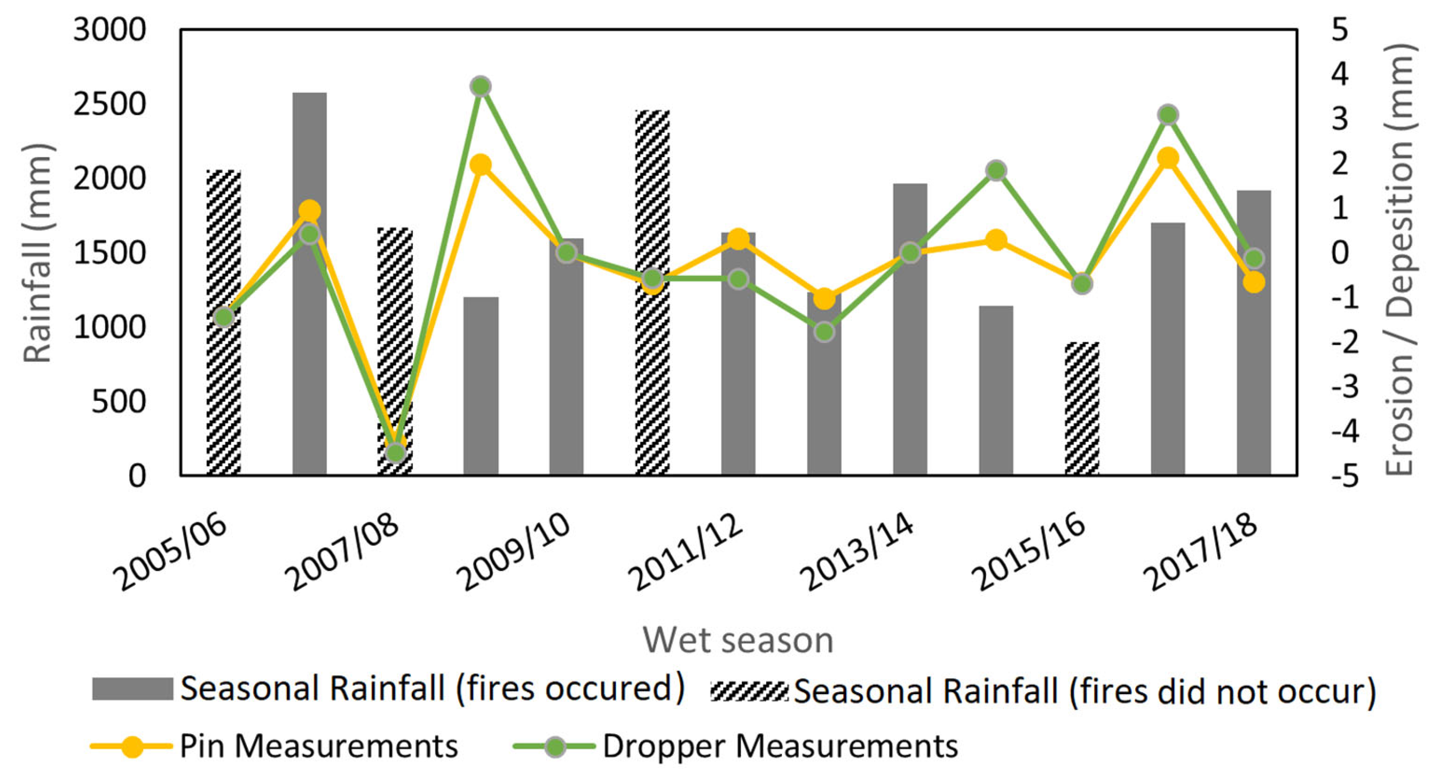
| Year | r | No. of Points | % of Points Burnt | Burnt Only r | Seasonal Rainfall (mm) |
|---|---|---|---|---|---|
| 2006 | no fire detected by NAFI | 2060 | |||
| 2007 | 0.26 | 21 | 100% | 0.26 | 2577 |
| 2008 | no fire detected by NAFI | 1669 | |||
| 2009 | 0.31 | 21 | 100% | 0.31 | 1201 |
| 2010 | no erosion measurements | 1596 | |||
| 2011 | no fire detected by NAFI | 2457 | |||
| 2012 | 0.22 | 21 | 100% | 0.22 | 1637 |
| 2013 | 0.17 | 17 | 82% | 0.14 | 1238 |
| 2014 | no erosion measurements | 1963 | |||
| 2015 | 0.33 | 12 | 100% | 0.33 | 1142 |
| 2016 | no fire detected by NAFI | 898 | |||
| 2017 | 0.30 | 14 | 100% | 0.30 | 1702 |
| 2018 | 0.17 | 21 | 52% | 0.66 | 1919 |
| Site ID | r | No. of Years Available | Burnt Only r | No. of Years Site Was Burnt |
|---|---|---|---|---|
| 1 | 0.20 | 6 | 0.17 | 5 |
| 2 | 0.39 | 6 | 0.60 | 5 |
| 3 | 0.10 | 6 | 0.22 | 5 |
| 4 | 0.10 | 7 | 0.17 | 6 |
| 5 | 0.20 | 7 | 0.00 | 6 |
| 6 | 0.17 | 7 | 0.41 | 5 |
| 7 | 0.33 | 7 | 0.20 | 5 |
| 8 | 0.20 | 7 | 0.00 | 5 |
| 9 | 0.77 | 6 | 0.57 | 4 |
| 10 | 0.62 | 6 | 0.47 | 4 |
| 11 | 0.46 | 6 | 0.62 | 3 |
| 12 | 0.49 | 6 | 0.51 | 3 |
| 13 | 0.70 | 7 | 0.57 | 4 |
| 14 | 0.20 | 7 | 0.17 | 4 |
| 15 | 0.78 | 6 | 0.94 | 5 |
| 16 | 0.10 | 7 | 0.32 | 3 |
| 17 | 0.40 | 6 | 0.92 | 3 |
| 18 | 0.14 | 7 | 0.33 | 3 |
| 19 | 0.51 | 7 | 0.88 | 4 |
| 20 | 0.59 | 5 | 1 | 2 |
| 21 | 0.30 | 5 | 1 | 2 |
Disclaimer/Publisher’s Note: The statements, opinions and data contained in all publications are solely those of the individual author(s) and contributor(s) and not of MDPI and/or the editor(s). MDPI and/or the editor(s) disclaim responsibility for any injury to people or property resulting from any ideas, methods, instructions or products referred to in the content. |
© 2024 by the authors. Licensee MDPI, Basel, Switzerland. This article is an open access article distributed under the terms and conditions of the Creative Commons Attribution (CC BY) license (https://creativecommons.org/licenses/by/4.0/).
Share and Cite
Bretreger, D.; Hancock, G.R.; Lowry, J.; Senanayake, I.P.; Yeo, I.-Y. The Impacts of Burn Severity and Frequency on Erosion in Western Arnhem Land, Australia. Sensors 2024, 24, 2282. https://doi.org/10.3390/s24072282
Bretreger D, Hancock GR, Lowry J, Senanayake IP, Yeo I-Y. The Impacts of Burn Severity and Frequency on Erosion in Western Arnhem Land, Australia. Sensors. 2024; 24(7):2282. https://doi.org/10.3390/s24072282
Chicago/Turabian StyleBretreger, David, Gregory R. Hancock, John Lowry, Indishe P. Senanayake, and In-Young Yeo. 2024. "The Impacts of Burn Severity and Frequency on Erosion in Western Arnhem Land, Australia" Sensors 24, no. 7: 2282. https://doi.org/10.3390/s24072282
APA StyleBretreger, D., Hancock, G. R., Lowry, J., Senanayake, I. P., & Yeo, I.-Y. (2024). The Impacts of Burn Severity and Frequency on Erosion in Western Arnhem Land, Australia. Sensors, 24(7), 2282. https://doi.org/10.3390/s24072282