Rapid Urbanization and Implications for Flood Risk Management in Hinterland of the Pearl River Delta, China: The Foshan Study


Abstract
:1. Introduction
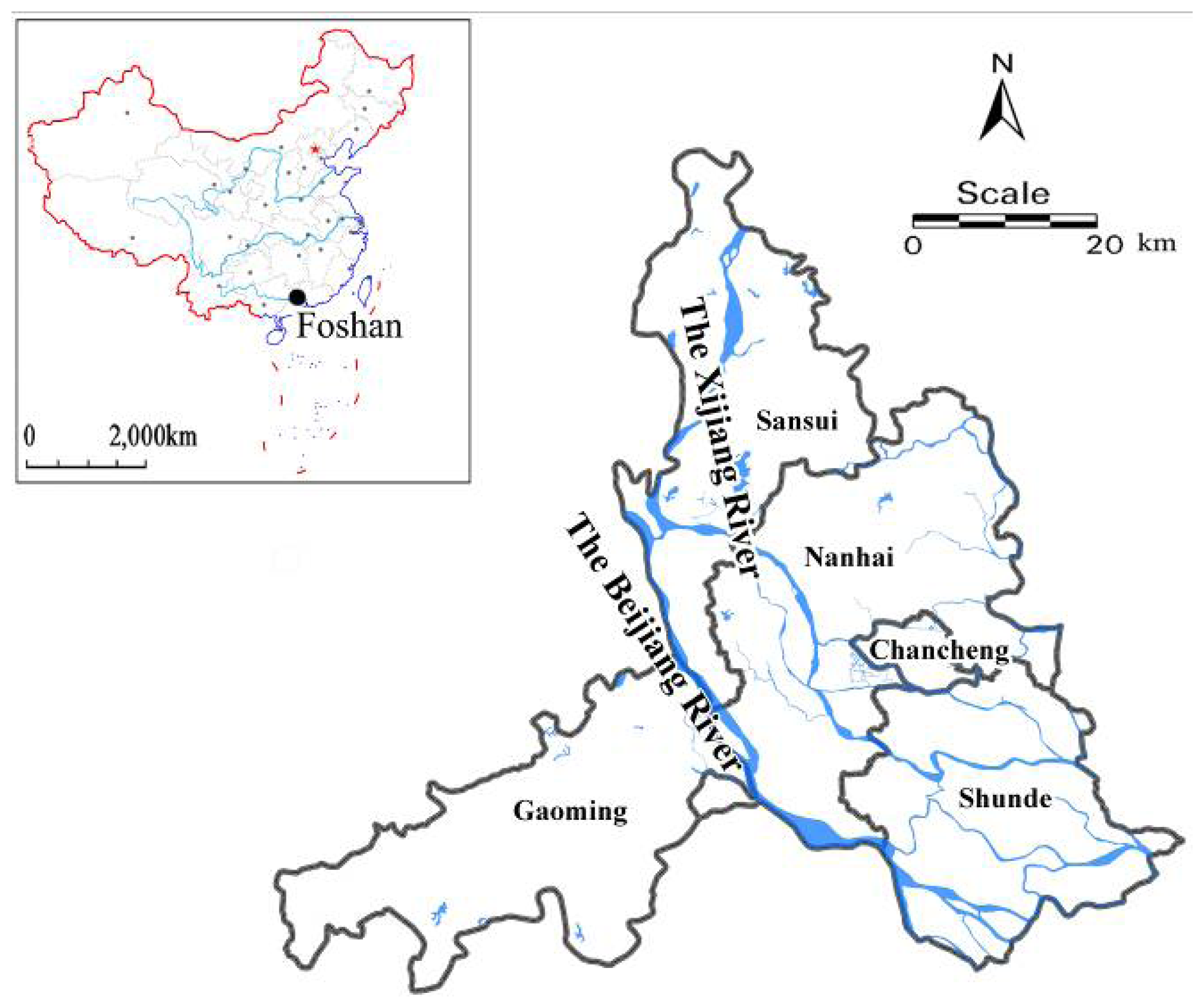
2. Study area
3. Methodology
3.1 Maps processing
3.2 Accuracy Assessment
3.3 Land use and land cover change detection
4. Results and discussion
4.1 Land use dynamics
4.2 Urban developmental pattern
4.3 Flood hazards as a response to urbanization and land use
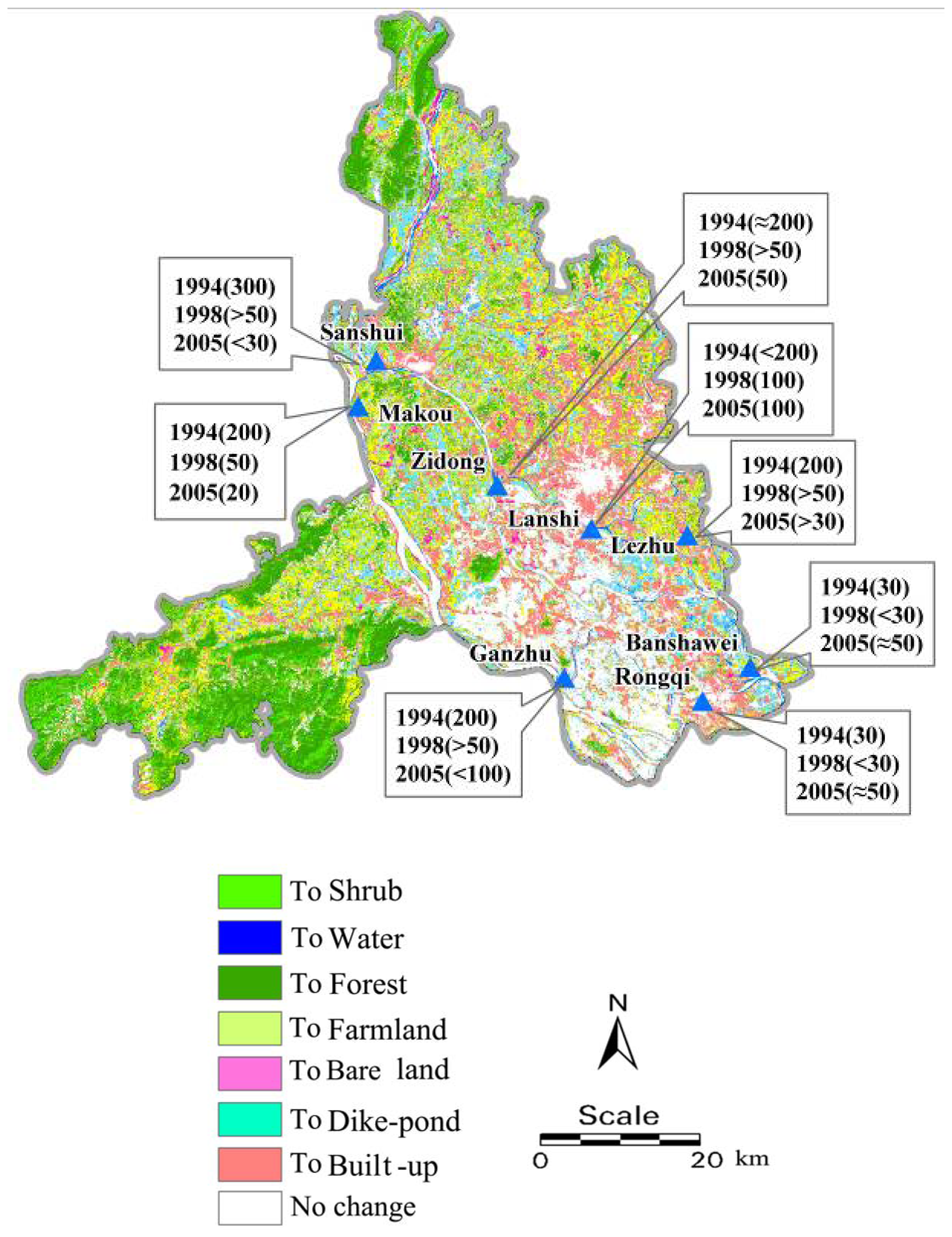
4.3.1 Flood hazards associated with urban sprawl and declining drainage system
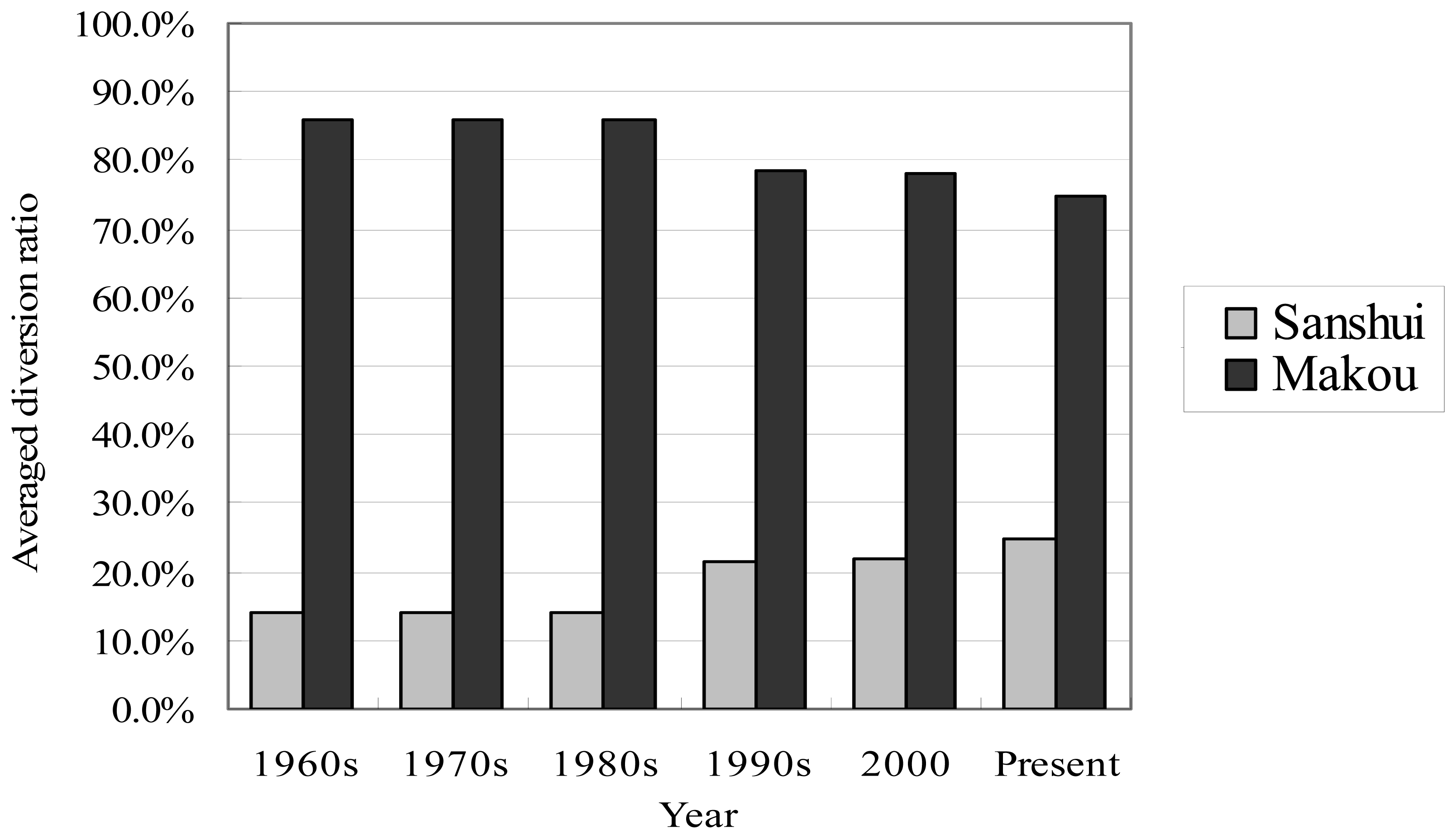
4.3.2 Flood hazards associated with irrational land use along the rivers
4.4 Implications for sustainable management of flood risk
5. Conclusions
Acknowledgments
References and Notes
- Chase, T.N.; Pielke, R.A.; Kittel, T.G.F.; Nemani, R.R.; Running, S.W. Simulated impacts of historical land cover changes on global climate in northern winter. Climate Dynamics 1999, 16, 93–105. [Google Scholar]
- Lambin, E.F.; Turner, B.L.; Geist, H.J.; Agbola, S.B.; Angelsen, A.; Bruce, J.W.; Coomes, O.; Dirzo, R.; Fischer, G.; Folke, C.; George, P.S.; Homewood, K.; Imbernon, J.; Leemans, R.; Li, X.; Moran, E.F.; Mortimore, M.; Ramakrishnan, P.S.; Richards, J.F.; Skånes, H.; Steffen, W.; Stone, G.; Svedin, U.; Veldkamp, T.A.; Vogel, C.; Xu, J. The causes of land-use and land-cover change: Moving beyond the myths. Global Environmental Change: Human and Policy Dimensions 2001, 11(4), 261–269. [Google Scholar]
- Grimm, N.B.; Grove, J.M.; Pickett, S.T.A.; Redman, C.L. Integrated approaches to long-term studies of urban ecological systems. Bioscience 2000, 50, 571–584. [Google Scholar]
- Masek, J.G.; Lindsay, F.E.; Goward, S.N. Dynamics of urban growth in the Washington DC metropolitan area, 1973-1996, from Landsat observations. International Journal of Remote Sensing 2000, 21, 3473–3486. [Google Scholar]
- Brath, A.; Montanari, A.; Moretti, G. Assessing the effect on flood frequency of land use change via hydrological simulation (with uncertainty). Journal of Hydrology 2006, 324, 141–153. [Google Scholar]
- Robinson, D.A.; Blackman, J.D. Soil erosion and flooding: Consequences on land use policy and agricultural practice on the South Downs, East Sussex, UK. Land Use Policy 1990, 7, 41–52. [Google Scholar]
- Tong, S.T.Y. The hydrologic effects of urban land use: A case study of the little Miami River Basin. Landscape and Urban Planning 1990, 19(1), 99–105. [Google Scholar]Schwarzl, S. [28] Causes and effects of flood catastrophes in the Alps—Examples from summer 1987. Energy and Buildings 1991, 16, 1085–1103. [Google Scholar]
- Suhari, S.; Siebenhüner, M. Environmental geology for land use and regional planning in the Bandung Basin, West Java, Indonesia. Journal of Southeast Asian Earth Sciences 1993, 8, 557–566. [Google Scholar]
- Woube, M. Flooding and sustainable land–water management in the lower Baro–Akobo river basin, Ethiopia. Applied Geography 1999, 19, 235–251. [Google Scholar]
- Shrubsole, D. Flood management in Canada at the crossroads. Environmental Hazards 2000, 2, 63–75. [Google Scholar]
- Campana, N.A.; Tucci, C. E. M. Predicting floods from urban development scenarios: case study of the Dilúvio Basin, Porto Alegre, Brazil. Urban Water 2001, 3, 113–124. [Google Scholar]
- Crooks, S.; Davies, H. Assessment of land use change in the Thames catchment and its effect on the flood regime of the river. Physics and Chemistry of the Earth, Part B: Hydrology, Oceans and Atmosphere 2001, 26, 583–591. [Google Scholar]
- de Roo, A.; Odijk, M.; Schmuck, G.; Koster, E.; Lucieer, A. Assessing the effects of land use changes on floods in the Meuse and Oder catchment. Physics and Chemistry of the Earth, Part B: Hydrology, Oceans and Atmosphere 2001, 26, 593–599. [Google Scholar]
- Yin, H.; Li, C. Human impact on floods and flood disasters on the Yangtze River. Geomorphology 2001, 41, 105–109. [Google Scholar]
- Khan, S.D. Urban development and flooding in Houston Texas, inferences from remote sensing data using neural network technique. Environmental Geology 2005, 47, 1120–1127. [Google Scholar]
- Niehoff, D.; Fritsch, U.; Bronstert, A. Land-use impacts on storm-runoff generation: scenarios of land-use change and simulation of hydrological response in a meso-scale catchment in SW-Germany. Journal of Hydrology 2002, 267, 80–93. [Google Scholar]
- Liu, H. Land use impacts on flood disaster in the middle reaches of the Yangtze River. Resources and Environment in the Yangtze Basin 2004, 3, 616–620. (in Chinese). [Google Scholar]
- Sullivan, A.; Ternan, J.L.; Williams, A.G. Land use change and hydrological response in the Camel catchment, Cornwall. Applied Geography 2004, 24, 119–137. [Google Scholar]
- Shi, P.J.; Ge, Y.; Yuan, Y.; Guo, W.P. Integrated Risk Management of Flood Disasters in Metropolitan Areas of China. International Journal of Water Resources Development 2005, 21, 613–627. [Google Scholar]
- Tu, M.; Hall, M.J.; de Laat, P.J.M.; de Wit, M.J.M. Extreme floods in the Meuse river over the past century: aggravated by land-use changes? Physics and Chemistry of the Earth 2005, 30, 267–276. [Google Scholar]
- Zhang, X.; Yu, X.; Wu, S.; Zhang, M.; Li, J. Response of land use/coverage change to hydrological dynamics at watershed scale in the Loess Plateau of China. Acta Ecologica Sinica 2007, 27, 414–421. [Google Scholar]
- Guangdong Statistical Bureau, Guangdong statistical yearbook 2002; China Statistics Press: Beijing, 2002. (in Chinese)
- Guangdong Statistical Bureau, Guangdong statistical yearbook 2006; China Statistics Press: Beijing, 2006. (in Chinese)
- Huang, Z.; Zhang, W. Impacts of artificial factors on the evolution of geomorphology during recent thirty years in the Zhujiang delta. Quaternary Sciences 2004, 24, 394–401. (in Chinese). [Google Scholar]
- Chen, X.H. Variation of flood in the Pearl River Delta and flood risk and insurance. Tropical Geograph 1999, 19, 117–123. (in Chinese). [Google Scholar]
- Water resources administration of Foshan. River basin (region) comprehensive planning report of Foshan 2000, 58–115. (in Chinese).
- Water resources administration of Foshan. An access to historical flood data since the 1960s. ( http://www.fswater.gov.cn/sfzl/shui/index.htm;in Chinese).
- Huang, D.; Huang, B.S.; Zheng, G.D.; Lai, G.W.; Chen, L.X.; Du, J.; Qiu, J. Calculation of Flood and Tide Hydrograph in Lower Reaches of the West River, North River and the Pearl River Delta. Guangdong Water Resources and Hydropower 2002, 2, 5–7. (in Chinese). [Google Scholar]
- Du, W.Y. The influence of river way evolvement on flood of Zhu river delta hydrographic net. Journal of Foshan University (Natural Science Edition) 2002, 20, 57–60. (in Chinese). [Google Scholar]
- Lai, G.W.; Huang, B.S.; Qiu, J.; Du, J. An analysis on fluvial processes in the great Beijiang leeve's reaches of the Beijiang River. Journal of Basic Science and Engineering 2002, 10, 405–411. (in Chinese). [Google Scholar]
- Li, D.B. Thinking on the 2005 flood in Foshan. http://www.fswater.gov.cn/sfzl/shui/index.htm;in Chinese).
- Liu, X. Cause Analysis of the variation of hydrological features of the Pearl River Delta. Water Resources Planning and Design 2004, 4, 9–13. (in Chinese). [Google Scholar]
- Peng, J.; Liao, W.G.; Yu, X.Z. Abnormal change of flood water level in hinterland of Pearl River Delta and its cause analysis. Journal of natural disaster 2004, 13, 50–54. (in Chinese). [Google Scholar]
- China National Committee of Agricultural Divisions, Technical Regulation of Investigation on Land Use Status; Surveying and Mapping Publishing House: Beijing, 1984; pp. 5–20. (in Chinese)
- Lucas, I.F.J.; Frans, J.M.; Wel, V.D. Accuracy assessment of satellite derived land-cover data: a review. Photogrammetric Engineering & Remote Sensing 1994, 60, 410–432. [Google Scholar]
- Ragab, R.; Cooper, J.D. Variability of unsaturated zone water transport parameters: implications for hydrological modelling.1. In situ measurements. Journal of Hydrology 1993, 148, 109–131. [Google Scholar]
- Jiang, S.Y. The influence of flood control scheduling of Felicia water conservancy pivotal project on the hydrologic forecasting. Journal of Foshan University (Natural Science Edition) 2002, 20, 61–63. (in Chinese). [Google Scholar]


| Classified | Reference | Sum | UA (%) | ||||||
|---|---|---|---|---|---|---|---|---|---|
| Built-up | Water | Forest | Dike-pond | Farmland | Shrub | Bare land | |||
| Built up | 12 | 0 | 0 | 0 | 0 | 1 | 2 | 15 | 80.0 |
| Water | 0 | 15 | 0 | 1 | 0 | 0 | 0 | 16 | 93.75 |
| Dike-pond | 0 | 2 | 0 | 11 | 0 | 0 | 0 | 13 | 84.62 |
| Forest | 0 | 0 | 18 | 0 | 1 | 1 | 0 | 20 | 90.00 |
| Farmland | 0 | 0 | 2 | 0 | 15 | 0 | 0 | 17 | 88.24 |
| Bare land | 0 | 0 | 0 | 0 | 0 | 0 | 12 | 12 | 100.0 |
| Shrub | 1 | 0 | 1 | 0 | 0 | 14 | 0 | 16 | 87.50 |
| Sum | 13 | 17 | 21 | 12 | 16 | 16 | 14 | ||
| PA (%) | 90.4 | 89.47 | 84.65 | 93.43 | 91.97 | 89.66 | 85.71 | ||
| OA (%) | 87.63 | ||||||||
| Classified | Reference | Sum | UA (%) | ||||||
|---|---|---|---|---|---|---|---|---|---|
| Built-up | Water | Forest | Dike-pond | Farmland | Shrub | Bare land | |||
| Built-up | 14 | 0 | 0 | 0 | 0 | 0 | 1 | 15 | 93.33 |
| Water | 0 | 15 | 0 | 1 | 0 | 0 | 0 | 17 | 88.24 |
| Dike-pond | 0 | 0 | 16 | 0 | 1 | 1 | 0 | 19 | 84.21 |
| Forest | 0 | 1 | 0 | 10 | 0 | 0 | 0 | 12 | 83.33 |
| Farmland | 0 | 0 | 1 | 0 | 14 | 0 | 0 | 16 | 87.50 |
| Bare land | 0 | 0 | 3 | 0 | 0 | 9 | 0 | 12 | 75.0 |
| Shrub | 1 | 0 | 0 | 0 | 0 | 0 | 15 | 16 | 93.75 |
| Sum | 15 | 17 | 21 | 12 | 16 | 10 | 16 | ||
| PA (%) | 93.11 | 90.66 | 76.83 | 85.29 | 85.39 | 90.0 | 93.75 | ||
| OA (%) | 86.98 | ||||||||
| Land use type | Water | Dike-pond | Farmland | Bare land | Forest | Shrub | Built-up |
|---|---|---|---|---|---|---|---|
| Water | 42.12 | 5.48 | 1.60 | 3.57 | 1.23 | 1.48 | 2.31 |
| Dike-pond | 26.72 | 55.52 | 25.19 | 17.11 | 17.26 | 12.03 | 11.42 |
| Farmland | 13.29 | 14.62 | 29.68 | 28.59 | 21.64 | 23.37 | 14.16 |
| Bare land | 3.72 | 2.94 | 3.73 | 5.91 | 2.45 | 3.85 | 2.03 |
| Forest | 4.63 | 4.30 | 15.05 | 14.85 | 30.38 | 21.36 | 5.98 |
| Shrub | 2.92 | 1.82 | 11.20 | 16.43 | 13.75 | 16.02 | 4.13 |
| Built-up | 6.64 | 15.33 | 13.55 | 13.54 | 13.29 | 21.88 | 59.94 |
 |
| Hydrological sites | the highest water level (m) | the maximum flow flux (m3/s) | ||||
|---|---|---|---|---|---|---|
| 1994 | 1998 | 2005 | 1994 | 1998 | 2005 | |
| Makou | 10.01 | 9.42 | 8.92 | 47000 | 46200 | 53200 |
| Sanshui | 10.38 | 9.59 | 9.19 | 16200 | 16200 | 16400 |
| Zidong | 7.62 | 7.3 | 7.2 | N | N | N |
| Lanshi | 6.01 | 5.84 | 5.81 | N | N | N |
| Lezhu | 3.57 | 3.77 | 3.8 | N | N | N |
| Ganzhu | 6.79 | 6.32 | 6.44 | N | N | N |
| Rongqi | 3.96 | 3.92 | 3.99 | N | N | N |
| Banshawei | 3.16 | 3.16 | 3.14 | N | N | N |
© 2008 by MDPI (http://www.mdpi.org). Reproduction is permitted for noncommercial purposes.
Share and Cite
Zhang, H.; Ma, W.-c.; Wang, X.-r. Rapid Urbanization and Implications for Flood Risk Management in Hinterland of the Pearl River Delta, China: The Foshan Study. Sensors 2008, 8, 2223-2239. https://doi.org/10.3390/s8042223
Zhang H, Ma W-c, Wang X-r. Rapid Urbanization and Implications for Flood Risk Management in Hinterland of the Pearl River Delta, China: The Foshan Study. Sensors. 2008; 8(4):2223-2239. https://doi.org/10.3390/s8042223
Chicago/Turabian StyleZhang, Hao, Wei-chun Ma, and Xiang-rong Wang. 2008. "Rapid Urbanization and Implications for Flood Risk Management in Hinterland of the Pearl River Delta, China: The Foshan Study" Sensors 8, no. 4: 2223-2239. https://doi.org/10.3390/s8042223
APA StyleZhang, H., Ma, W.-c., & Wang, X.-r. (2008). Rapid Urbanization and Implications for Flood Risk Management in Hinterland of the Pearl River Delta, China: The Foshan Study. Sensors, 8(4), 2223-2239. https://doi.org/10.3390/s8042223