Augmented Reality and Valorizing the Mesozoic Geological Heritage (Burgos, Spain)


Abstract
:
1. Introduction
2. Materials and Methods
2.1. Study Area and Geological Context
2.2. Inventory and Valuation of Geosites
2.3. Geoheritage and Georesources in Augmented Reality
3. Results and Discussion
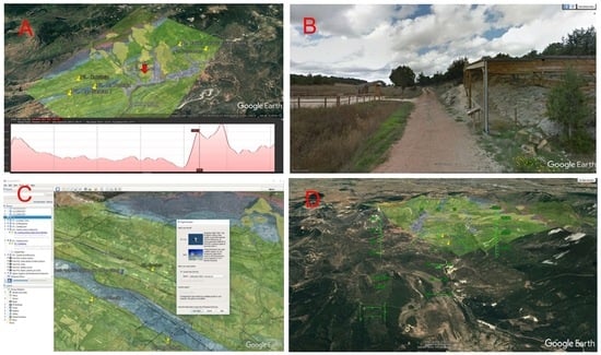
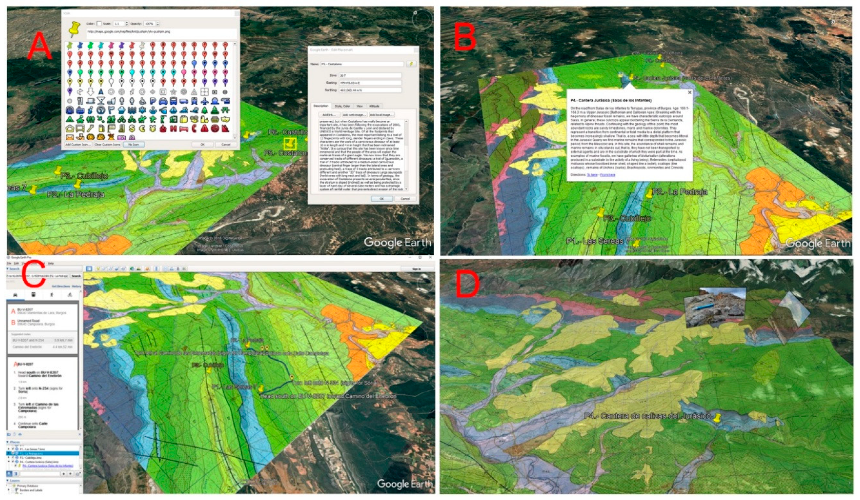
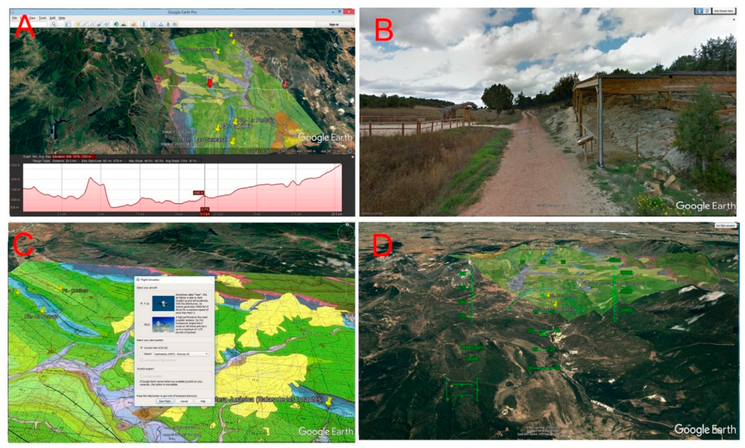
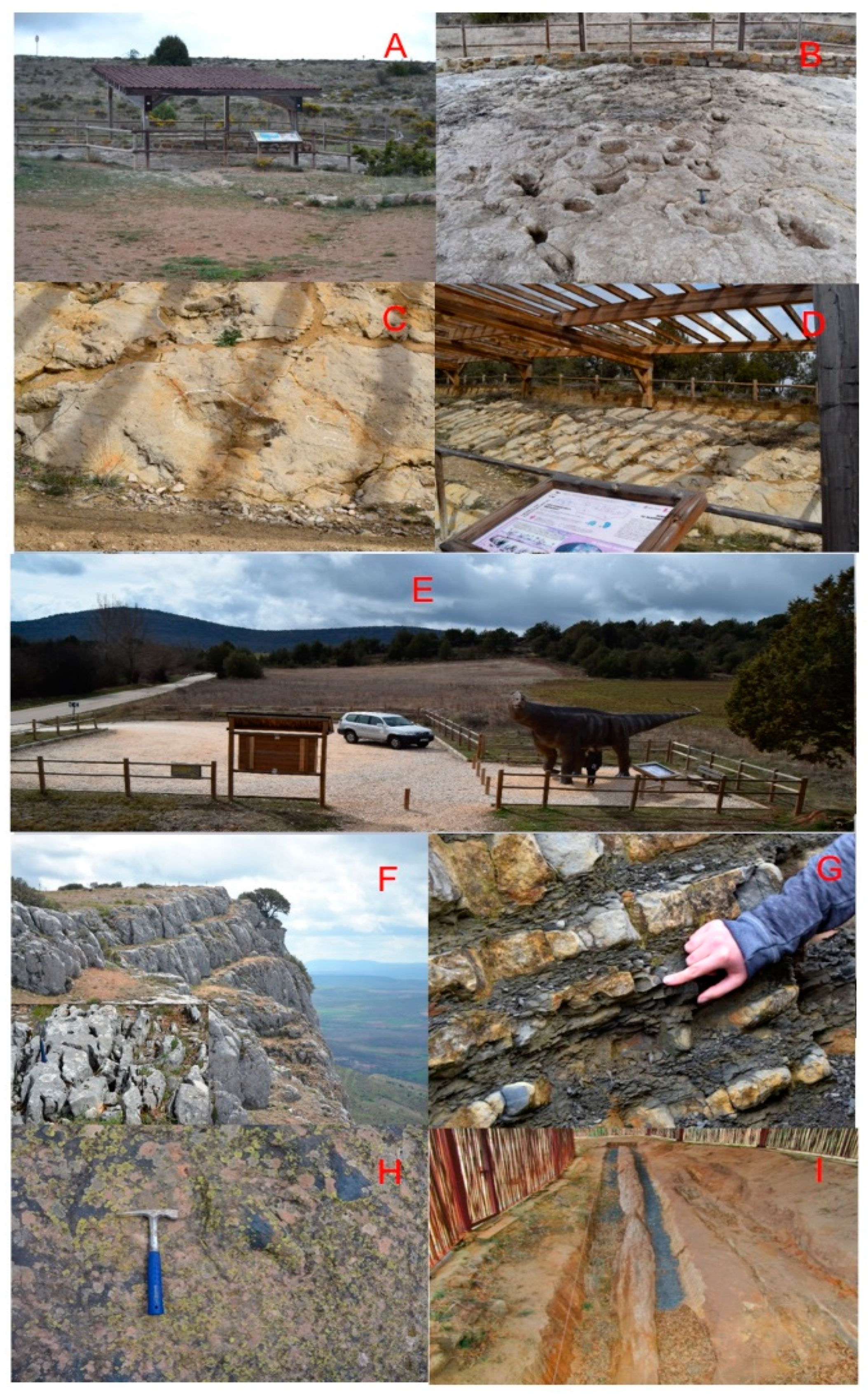
3.1. Geological Itinerary
3.2. Georesources Implemented in the Augmented Reality
3D Virtual Itinerary with Google Earth
4. Conclusions
Supplementary Materials
Author Contributions
Funding
Conflicts of Interest
References
- Gallego, E.; García-Cortés, A. Patrimonio geológico y áreas naturales protegidas. Geogaceta 1996, 19, 202–206. [Google Scholar]
- Carcavilla Urqauí, L.; López Martínez, J.; Durán Valsero, J.J. (Eds.) Patrimonio Geológico y Geodiversidad: Investigación, Conservación, Gestión y Relación Con Los Espacios Naturales Protegidos; Cuadernos del Museo Geominero No. 7; Instituto Geológico y Minero de España: Madrid, Spain, 2017; Volume 7, 360p. [Google Scholar]
- Gray, M. Geodiversity: Valuing and Conserving a Biotic Nature; Wiley: Hoboken, NJ, USA, 2003; 434p. [Google Scholar]
- Parks, K.E.; Mulligan, M. On the relationship between a resources based measure of geodiversity and broad scale biodiversity patterns. Biodivers. Conserv. 2010, 19, 2751–2766. [Google Scholar] [CrossRef]
- Barretino, D.; Wimbledon, W.A.P.; Gallego, E. Patrimonio Geológico: Conservación y Gestión; IGME: Madrid, Spain, 2000; 227p. [Google Scholar]
- Martínez Graña, A.M.; Goy Goy, J.L.; Zazo Cardeña, C. Natural Heritage mapping of the Las Batuecas-Sierra de Francia and Quilamas Nature Parks (SW Salamanca, Spain). J. Maps 2011, 7, 600–613. [Google Scholar] [CrossRef]
- Zouros, N.C. Geomorphosite assessment and management in protected areas of Greece Case study of the Lesvos Island coastal geomorphosites. Geogr. Helv. 2007, 62, 169–180. [Google Scholar] [CrossRef]
- Bruschi, V.M.; Cendrero, A. Geosite evaluation; can we measure intangible values? II Quaternario Ital. J. Quarternary Sci. 2005, 18, 293–306. [Google Scholar]
- Nicu, I.C. Tracking natural and anthropic risks from historical maps as a tool for cultural heritage assessment: A case study. Environ. Earth Sci. 2017, 76, 330. [Google Scholar] [CrossRef]
- Weng, Y.-H.; Sun, F.-S.; Grigsby, J.D. Geotools: An Android phone application in geology. Comput. Geosci. 2012, 44, 24–30. [Google Scholar] [CrossRef]
- Bailey, J.E.; Chen, A. The role of virtual globes in geoscience. Comput. Geosci. 2011, 37, 1–2. [Google Scholar] [CrossRef]
- Blenkinsop, T.G. Visualizing structural geology: From Excell to Google Earth. Comput. Geosci. 2012, 45, 52–56. [Google Scholar] [CrossRef]
- De Paor, D.; Whitmeyer, S.J. Geological and geophysical modelling on virtual globes using KML, COLLADA and Javascript. Comput. Geosci. 2011, 37, 100–110. [Google Scholar] [CrossRef]
- Karabinos, P. Adding structures to 3-D geologic maps. In Proceedings of the Geological Society of America Annual Meeting, Denver, CO, USA, 31 October–3 November 2010; Abstracts with Programs-Geological Society of America. Volume 42, p. 421. [Google Scholar]
- Martínez-Graña, A.M.; Serrano, L.; Gonzál ez-Delgado, J.A.; Dabrio, C.J.; Legoinha, P. Digital Geotourism: Tools and resources for sustainability and tourism management. Georoute “Route of the fossil footprints” (Monsagro, Salamanca, Spain). Int. J. Dig. Earth 2017, 10, 121–138. [Google Scholar] [CrossRef]
- García-Cortés, A.; Carcavilla, L.; Díaz-Martínez, E.; Vegas, J. Documento metodológico para la elaboración del inventario español de Lugares de Interés Geológico (IELIG). Instituto Geológico y Minero de España 2014, 12, 61. [Google Scholar]
- Brilha, J. Inventory and quantitative assessment of geosites and geodiversity sites: A review. Geoheritage 2016, 8, 119–134. [Google Scholar] [CrossRef]
- Reynard, E.; Perret1, A.; Bussard, J.; Grangier, L.; Martin, S. Integrated Approach for the Inventory and Management of Geomorphological Heritage at the Regional Scale. Geoheritage 2016, 8, 43–60. [Google Scholar] [CrossRef]
- Corbí, H.; Fierro, I.; Aberasturi, A.; Ferris, E.J.S. Potential Use of a Significant Scientific Geosite: The Messinian Coral Reef of Santa Pola (SE Spain). Geoheritage 2018, 10, 427–441. [Google Scholar] [CrossRef]
- González-Delgado, J.A.; Martínez-Graña, A.M.; Civis, J.; Sierro, F.J.; Goy, J.L.; Dabrio, C.J.; Ruiz, F.; González-Regalado, M.L.; Abad, M. Virtual 3D tour of the Neogene palaeontological heritage of Huelva (Guadalquivir Basin, Spain). Environ. Earth Sci. 2015, 73, 4609–4618. [Google Scholar] [CrossRef]
- Martínez-Graña, A.M.; Legoinha, P.; González-Delgado, J.A.; Dabrio, C.J.; Pais, J.; Goy, J.L.; Zazo, C.; Civis, J.; Armenteros, I.; Alonso-Gavilán, G.; et al. Augmented Reality in a hiking tour on the Miocene geoheritage of central Algarve cliffs (Portugal). Geoheritage 2017, 9, 121–131. [Google Scholar] [CrossRef]
- Martínez-Graña, A.M.; Bajo, I.; González-Delgado, J.A.; Cárdenas-Carretero, J.; Abad, M.; Legoinha, P. Virtual geo-resources applied to the palaeontological heritage in Sevilla (Guadalquivir Neogene basin, Spain). Geoheritage 2018, 10, 473–482. [Google Scholar] [CrossRef]
- Martínez-Graña, A.M.; González-Delgado, J.A.; Pallarés, S.; Goy, J.L.; Civis, J. 3D Virtual Itinerary for Education Using Google Earth as a Tool for the Recovery of the Geological Heritage of Natural Areas: Application in the “Las Batuecas Valley” Nature Park (Salamanca, Spain). Sustainability 2014, 6, 8567–8591. [Google Scholar] [CrossRef] [Green Version]
- Benito-Calvo, A.; Pérez-González, A. Geomorphology of the Sierra de Atapuerca and the Middle Arlanzón Valley (Burgos, Spain). J. Maps 2014, 11, 535–544. [Google Scholar] [CrossRef] [Green Version]
- Álvarez-Vázquez, M.Á.; De Uña-Álvarez, E. Inventory and Assessment of Fluvial Potholes to Promote Geoheritage Sustainability (Miño River, NW Spain). Geoheritage 2017, 9, 549–560. [Google Scholar] [CrossRef]
- Suzuki, D.; Takagi, H. Evaluation of Geosite for Sustainable Planning and Management in Geotourism. Geoheritage 2018, 10, 123–135. [Google Scholar] [CrossRef]
- Štrba, Ľ.; Kršák, B.; Sidor, C. Some Comments to Geosite Assessment, Visitors, and Geotourism Sustainability. Sustainability 2018, 10, 2589. [Google Scholar] [CrossRef]
- García Cortés y Carcavilla. 2018. Available online: http://www.igme.es/patrimonio/descargas/METODOLOGIA%20IELIG%20V16%20actualizaci%C3%B3n%202018.pdf (accessed on 3 December 2018).
- Kiili, K. Digital game-based learning: Towards an experiential gaming model. Internet High Educ. 2005, 8, 13–24. [Google Scholar] [CrossRef]
- Zingaro, D.; Porter, R. A model of consumer web navigational behavior: Conceptual development and application. J. Bus. Res. 2005, 58, 1019–1029. [Google Scholar]
- Huerta, P.; Torcida, F.; Farlow, J.O.; Montero, D. Exceptional preservation processes of 3D dinosaur footprin casts in Costalomo (Lower Cretaceous, Cameros Basin, Spain). Terra Nova 2012, 24, 136–141. [Google Scholar] [CrossRef]


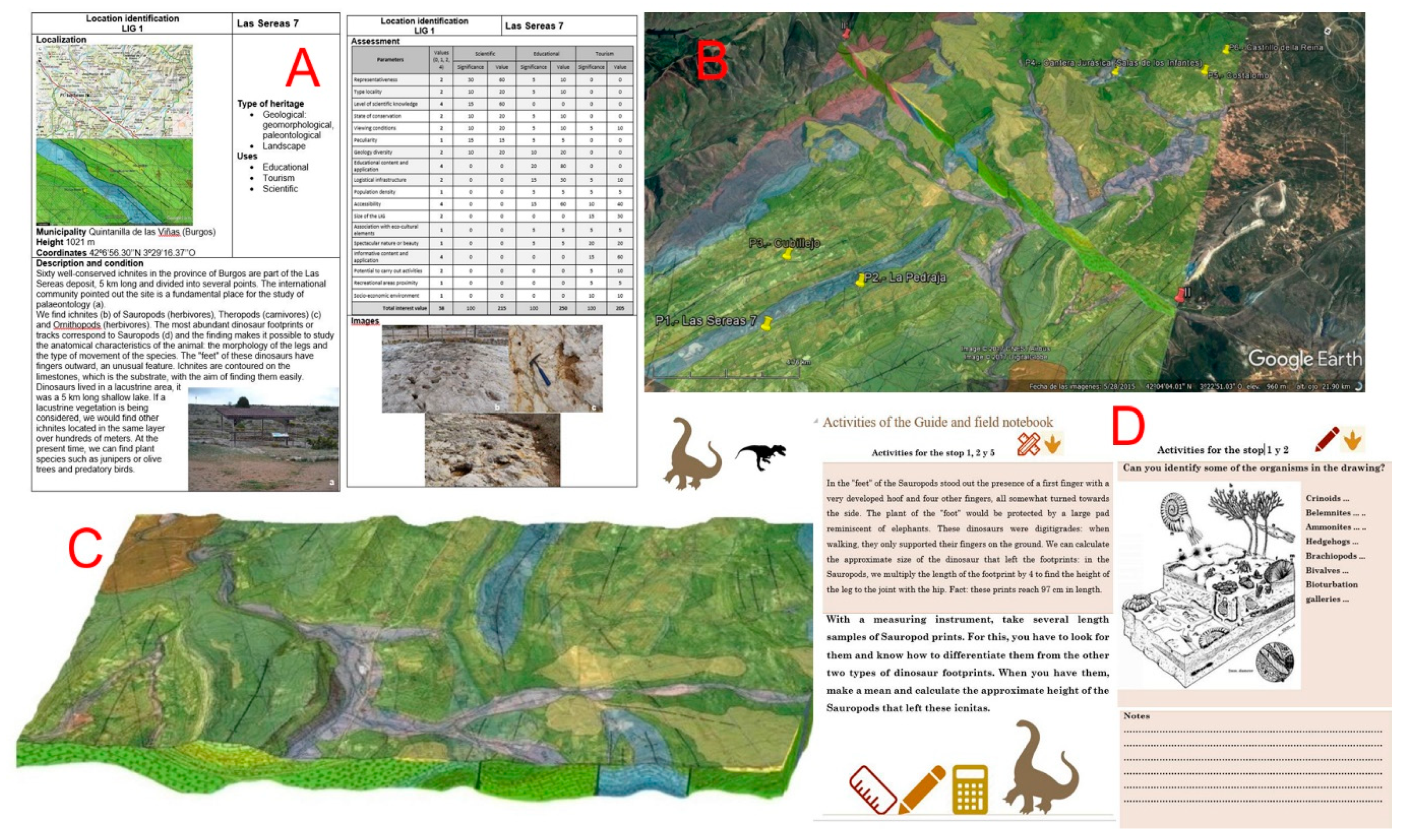
| Parameters | Intrinsic Value |
|---|---|
| Representativeness (quality of location to adequately illustrate the features of the domain) | |
| Little useful as a model to represent, even partially, a trait or process | 0 |
| Useful as a model to partially represent a trait or process | 1 |
| Useful as a model to represent a trait or process | 2 |
| Best-known example and geological domain level considered to represent a trait or process | 4 |
| Character type locality or benchmark (quality of place as a stratigraphic, paleontological and mineralogical reference) | Intrinsic value |
| Does not meet, by default, with these three following premises | 0 |
| Useful as a model to partially represent a trait or process | 1 |
| Useful as a model to represent a trait or process | 2 |
| Best-known example and geological domain level considered to represent a trait or process | 4 |
| Level of scientific knowledge of the location (geological relevance and scientific interest in publications and studies) | Intrinsic value |
| There are no published articles or doctoral theses on the place | 0 |
| Published studies and/or doctoral thesis about the location | 1 |
| Focus of research by scientific teams and the subject of doctoral theses and published papers that have been referenced in national scientific journals | 2 |
| Focus of research by scientific teams and the subject of doctoral theses and published papers in international journals | 4 |
| State of conservation (existence of physical deterioration of the trait) | Intrinsic value |
| The place has significant deterioration or is destroyed | 0 |
| With impairments that prevent appreciation of some features of interest | 1 |
| Some defects, which do not decisively affect its value or interest | 2 |
| The geosite is well-preserved | 4 |
| Viewing conditions (offered by the environment to observe the trait). | Intrinsic value |
| With elements that strongly mask the characteristics of interest | 0 |
| Contain elements that do not enable appreciation of some features of interest for the geosite | 1 |
| Contain elements that do not enable complete observation of the geosite, despite the difficulty | 2 |
| Perfectly and easily observable in its entirety | 4 |
| Rarity (shortage of similar traits as described) | Intrinsic value |
| There are quite a few similar places in the region | 0 |
| One of the few known examples at the regional level | 1 |
| Only example known at the regional level | 2 |
| Only example known at the national level (or international level) | 4 |
| Geological diversity (the existence of various types of geological interest in the same location) | Intrinsic value |
| The geosite only presents the main interest rate | 0 |
| The geosite has other interests in addition to the primary interest, which are not relevant | 1 |
| The geosite has two types of interests in addition to the primary interest, or only one relevant interest | 2 |
| The geosite has three or more types of interests in addition to the primary interest but only two interests are relevant | 4 |
| Educational content/educational use identified | Intrinsic value and use |
| Does not meet, by default, with the following three premises | 0 |
| Illustrates university content of curricula | 1 |
| Illustrates curricula at all levels of the educational system | 2 |
| Commonly used in educational activities at all levels of the educational system | 4 |
| Logistics infrastructure (Existence of lodging and restaurants) | Use value |
| Does not meet, by default, with the following three premises | 0 |
| Accommodations for groups with 20 people within 25 km | 1 |
| Accommodations for groups with 40 people within 25 km | 2 |
| Accommodations for groups of 40 within 5 km | 4 |
| Population density (demand immediate potential) (Linked to the potential number of visits and the increased potential for vandalism) | Use value and protection |
| Less than 200,000 inhabitants within 50 km | 1 |
| Between 200,000 and 1,000,000 inhabitants within 50 km | 2 |
| More than 1,000,000 inhabitants within 50 km | 4 |
| Accessibility (Linked to easier access and a greater potential for vandalism) | Use value and protection |
| Does not comply, by default, with the following three premises (road asphalted with no possibility of parking, path or path, track TT, boat, etc.) | 0 |
| Direct access by dirt road but passable | 1 |
| Direct access by paved road with parking for cars | 2 |
| Direct access by paved road with parking for coach buses | 4 |
| Size of the geosite | Use value and protection |
| Metric traits (vulnerable by visits, such as speleothems, etc.) | 0 |
| Not vulnerable as visits but more sensitive to human activities and decametric aggressive traits | 1 |
| Hectometric features that may experience deterioration by human activities | 2 |
| Kilometric traits that are not damaged by human activities | 4 |
| Association with other nature/cultural elements. The site also does not contain other elements of geological interest | Use value |
| There are no elements of natural or cultural heritage within a radius of 5 km | 0 |
| Presence of a single element of natural or cultural heritage within 5 km | 1 |
| Presence of various elements of natural and cultural heritage within 5 km | 2 |
| Presence of various elements of natural and cultural heritage within 5 km | 4 |
| Visual beauty or spectacular trait or quality | Intrinsic value |
| Does not meet, by default, with the following three premises | 0 |
| Used only in the local tourist iconography | 1 |
| Used occasionally in the tourist iconography at the national or international level | 2 |
| Typically used in the tourist iconography at the national or international level | 4 |
| Informative content/use detected. The feature is easily identifiable or already used for this purpose | Intrinsic value and use |
| Does not meet, by default, with the following three premises | 0 |
| Demonstrates clear and expressive manner for groups of certain cultural levels | 1 |
| Demonstrates clear and expressive collective cultural level any way about the importance or usefulness of geology | 2 |
| Commonly used for outreach activities | 4 |
| Potential for tourism and recreational activities. The location satisfies the conditions for conducting activities or is already used for this purpose | Intrinsic value and use |
| No tourist possibilities or recreational activities | 0 |
| You can make develop one of these activities | 1 |
| You can perform these activities | 2 |
| These activities are usually organised | 4 |
| Proximity to recreational areas (demand immediate potential) Linked to the potential number of visits and the increased potential for vandalism | Use value and protection |
| Place located more than 5 km from recreational areas (campsites, beaches, etc.) | 0 |
| Geosite located within 5 km of a recreational area (campsites, popular beaches, national or natural parks and visitor centres) | 1 |
| Geosite located within 2 km of a recreational area | 2 |
| Geosite situated within 500 m of a recreational area | 4 |
| Socioeconomic setting. Socioeconomic conditions that favour its use as a factor of local development | Use value |
| Region with indices of income per capita, education and occupation above the regional average | 0 |
| Region with per capita income levels, education and occupation similar to the regional average but below the national average | 1 |
| Region with per capita income levels, education and occupation below the regional average | 2 |
| Site located in a region with socioeconomic decline | 4 |
| Parameter | Scientific Interest | Educational Interest | Tourist/Recreational Interest |
|---|---|---|---|
| Representativeness | 30 | 5 | --- |
| Character type locality | 10 | 5 | --- |
| Degree of scientific knowledge of the location | 15 | --- | --- |
| State of conservation | 10 | 5 | --- |
| Viewing conditions | 10 | 5 | 5 |
| Rarity | 15 | 5 | --- |
| Geological diversity | 10 | 10 | --- |
| Learning objectives/educational use | --- | 20 | --- |
| Logistics infrastructure | --- | 15 | 5 |
| Population density | --- | 5 | 5 |
| Accessibility | --- | 10 | 10 |
| Intrinsic fragility (geosite size) | --- | 5 | 15 |
| Association with elements natural and/or cultural | --- | 5 | 5 |
| Beauty or spectacularity | --- | 5 | 20 |
| Informative content/use | --- | --- | 15 |
| Potential for tourism/recreation activities | --- | --- | 5 |
| Proximity to recreational areas | --- | --- | 5 |
| Socioeconomic environment | --- | --- | 10 |
| Total | 100 | 100 | 100 |
| Geosites | 1 | 2 | 3 | 4 | 5 | 6 |
|---|---|---|---|---|---|---|
| Representativeness | 2 | 2 | 1 | 2 | 4 | 2 |
| Character type locality | 2 | 1 | 1 | 1 | 4 | 1 |
| Degree of scientific knowledge of the location | 2 | 4 | 1 | 2 | 4 | 0 |
| State of conservation | 2 | 4 | 4 | 1 | 4 | 4 |
| Viewing conditions | 4 | 4 | 4 | 4 | 2 | 4 |
| Rarity | 2 | 1 | 1 | 2 | 4 | 4 |
| Geological diversity | 0 | 2 | 2 | 2 | 2 | 1 |
| Learning objectives/educational use | 4 | 2 | 1 | 2 | 2 | 2 |
| Logistics infrastructure | 4 | 2 | 1 | 4 | 1 | 4 |
| Population density | 1 | 1 | 1 | 1 | 1 | 1 |
| Accessibility | 2 | 4 | 0 | 4 | 1 | 1 |
| Intrinsic fragility (geosite size) | 1 | 2 | 4 | 1 | 1 | 1 |
| Association with elements natural and/or cultural | 2 | 2 | 2 | 1 | 0 | 1 |
| Beauty or spectacularity | 2 | 2 | 1 | 2 | 2 | 2 |
| Informative content/use | 4 | 2 | 1 | 2 | 4 | 2 |
| Potential for tourism/recreation activities | 2 | 2 | 0 | 2 | 2 | 1 |
| Proximity to recreational areas | 1 | 2 | 0 | 2 | 0 | 1 |
| Socioeconomic environment | 1 | 1 | 1 | 1 | 1 | 1 |
| Total | 38 | 38 | 26 | 28 | 29 | 30 |
| Geosites | 1 | 2 | 3 | 4 | 5 | 6 |
|---|---|---|---|---|---|---|
| Scientific interest | 215 | 225 | 170 | 110 | 210 | 190 |
| Didactic interest | 250 | 250 | 130 | 250 | 165 | 210 |
| Tourist-cultural interest | 205 | 200 | 145 | 145 | 125 | 135 |
| Total | 670 | 675 | 445 | 505 | 500 | 535 |
© 2018 by the authors. Licensee MDPI, Basel, Switzerland. This article is an open access article distributed under the terms and conditions of the Creative Commons Attribution (CC BY) license (http://creativecommons.org/licenses/by/4.0/).
Share and Cite
Martínez-Graña, A.; González-Delgado, J.Á.; Ramos, C.; Gonzalo, J.C. Augmented Reality and Valorizing the Mesozoic Geological Heritage (Burgos, Spain). Sustainability 2018, 10, 4616. https://doi.org/10.3390/su10124616
Martínez-Graña A, González-Delgado JÁ, Ramos C, Gonzalo JC. Augmented Reality and Valorizing the Mesozoic Geological Heritage (Burgos, Spain). Sustainability. 2018; 10(12):4616. https://doi.org/10.3390/su10124616
Chicago/Turabian StyleMartínez-Graña, Antonio, José Ángel González-Delgado, Celia Ramos, and Juan Carlos Gonzalo. 2018. "Augmented Reality and Valorizing the Mesozoic Geological Heritage (Burgos, Spain)" Sustainability 10, no. 12: 4616. https://doi.org/10.3390/su10124616
APA StyleMartínez-Graña, A., González-Delgado, J. Á., Ramos, C., & Gonzalo, J. C. (2018). Augmented Reality and Valorizing the Mesozoic Geological Heritage (Burgos, Spain). Sustainability, 10(12), 4616. https://doi.org/10.3390/su10124616