Assessment of Land Cover Change and Its Impact on Changes in Soil Erosion Risk in Nepal


Abstract
:
1. Introduction
2. Materials and Methods
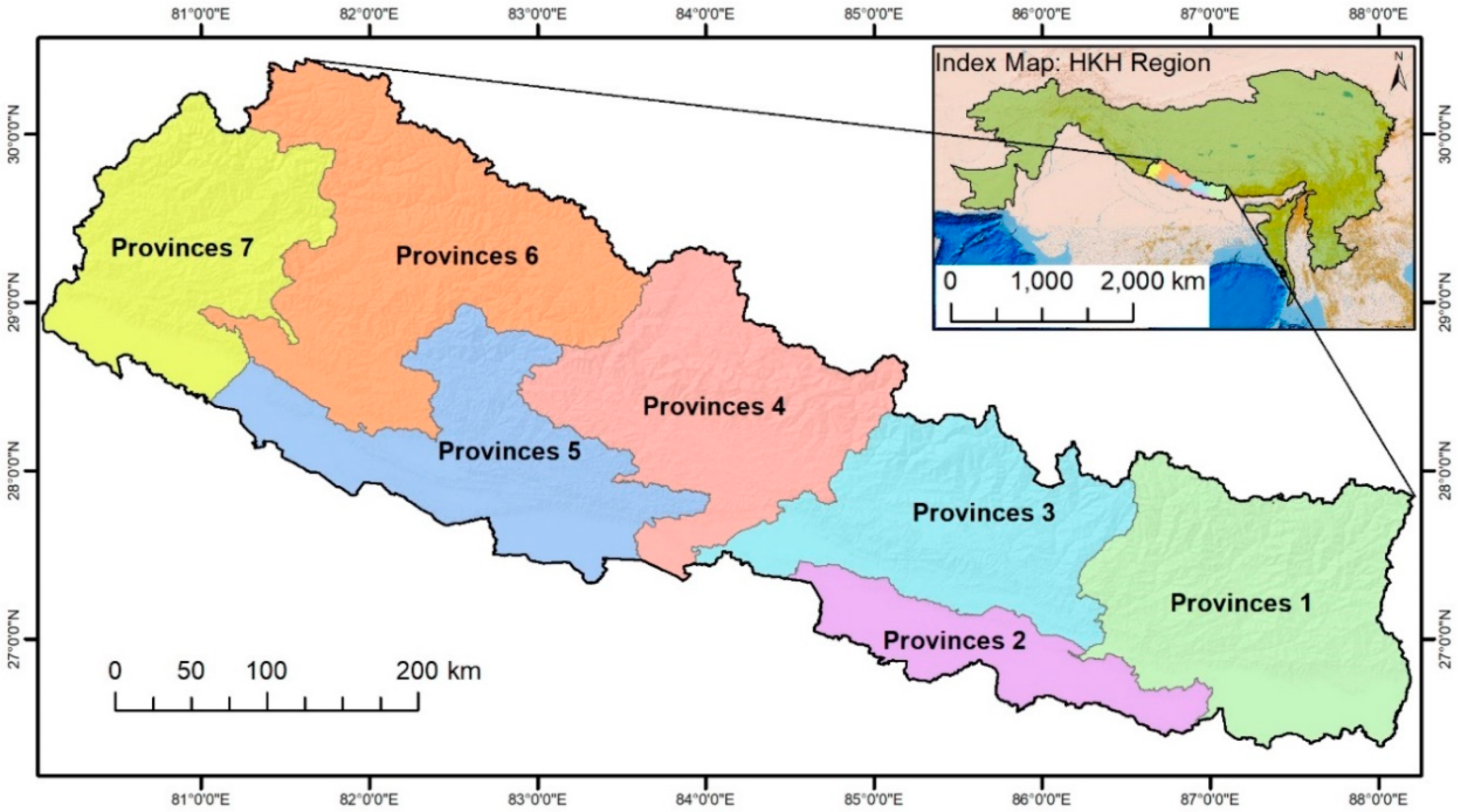
2.1. Study Area
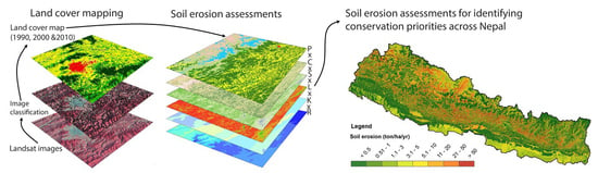
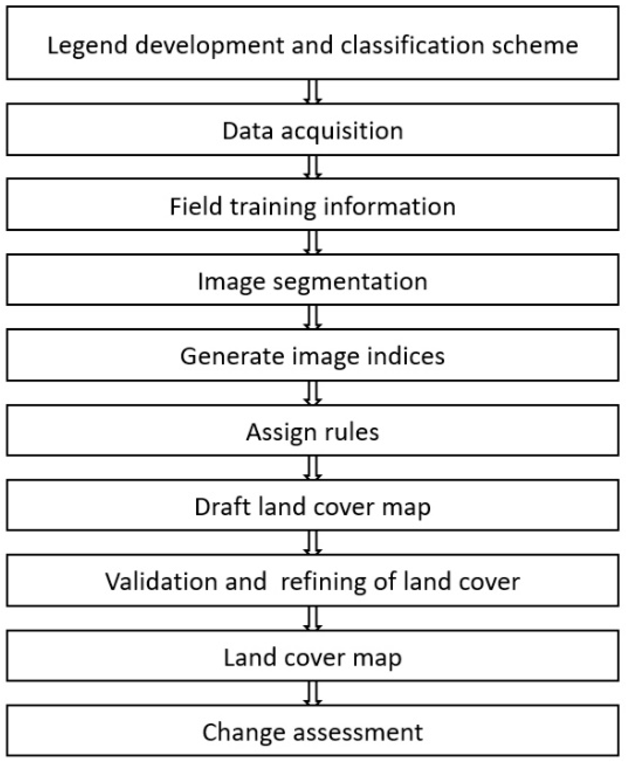
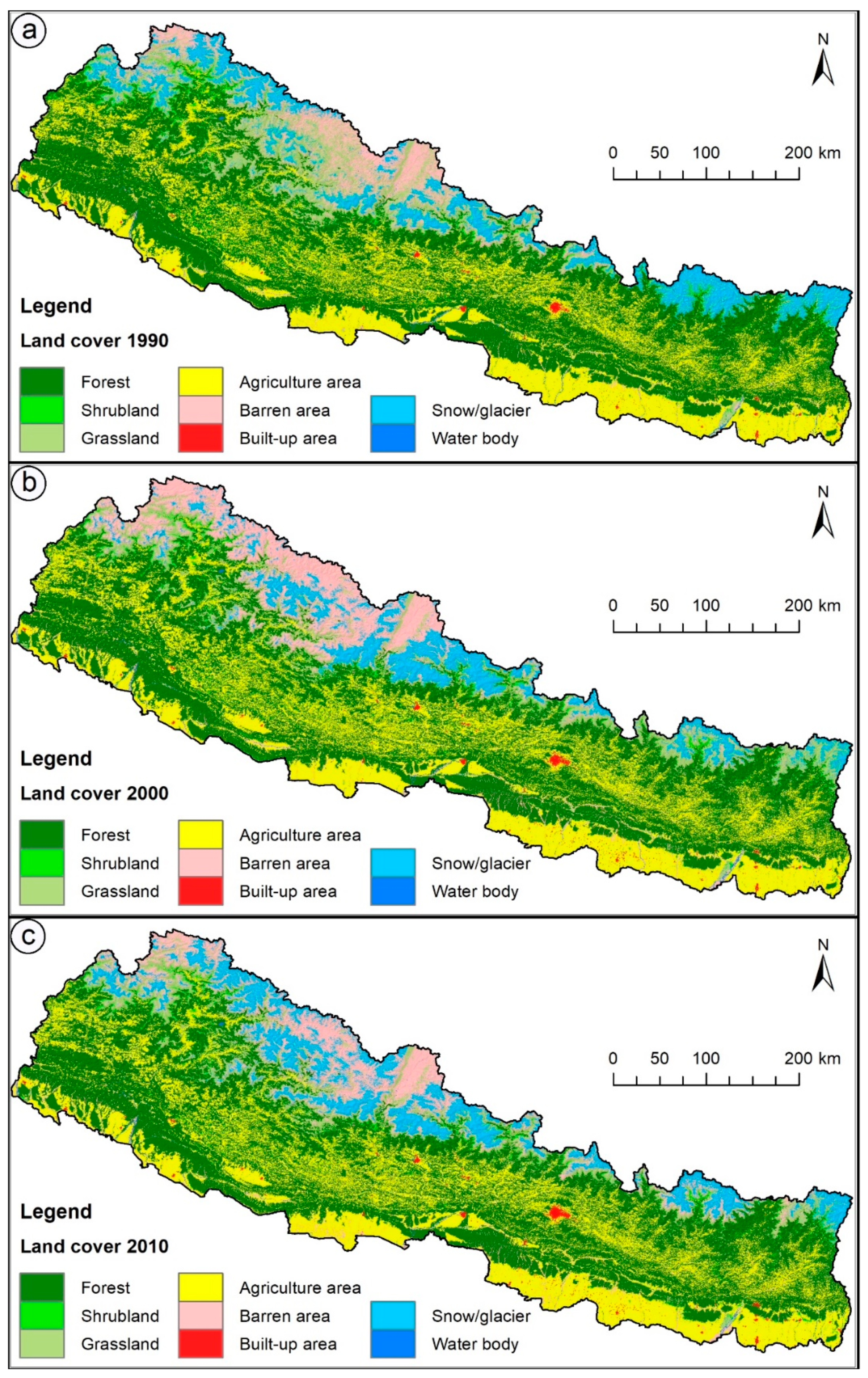
2.2. Assessment of Land Cover
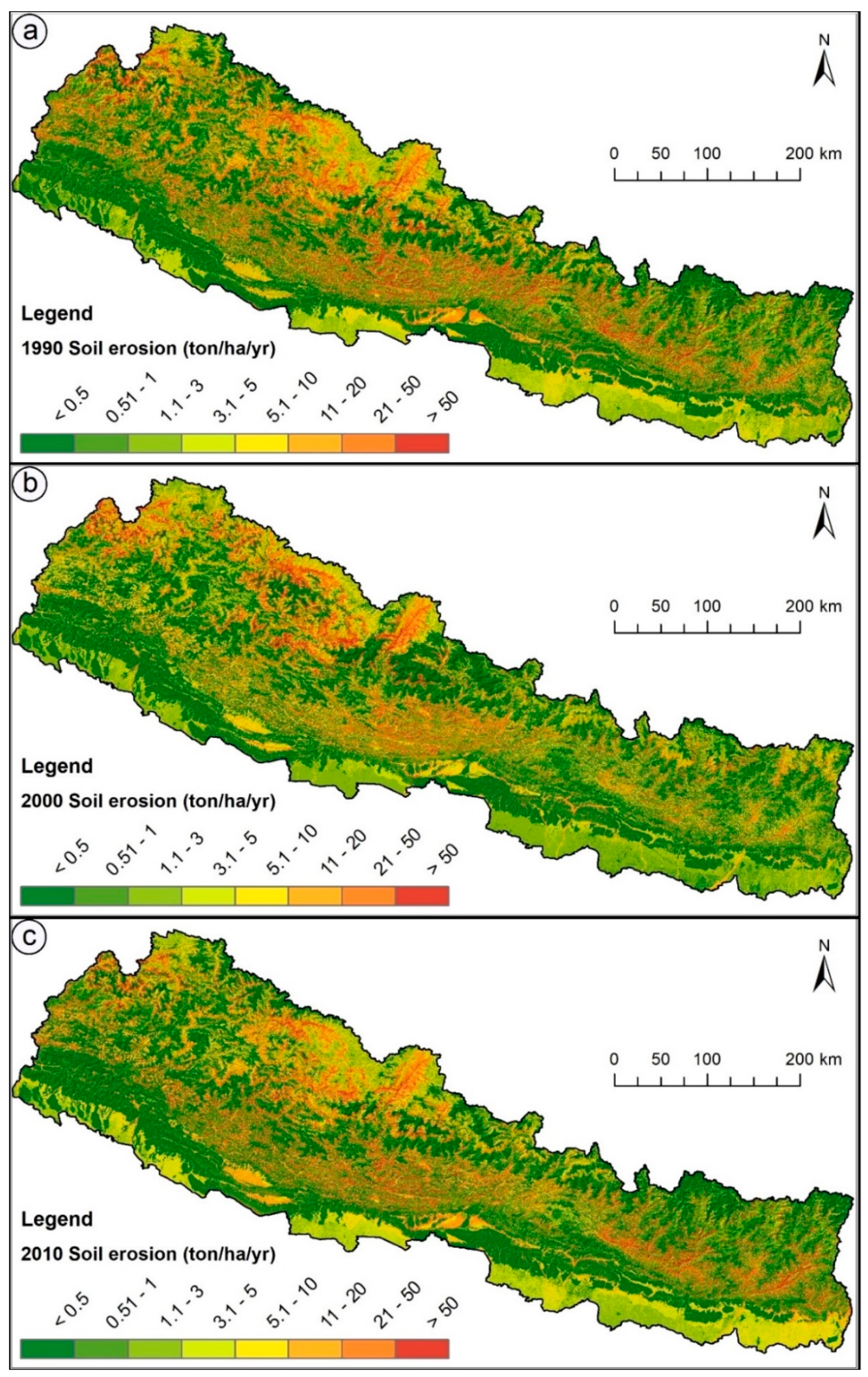
2.3. Estimation of Soil Erosion Areas
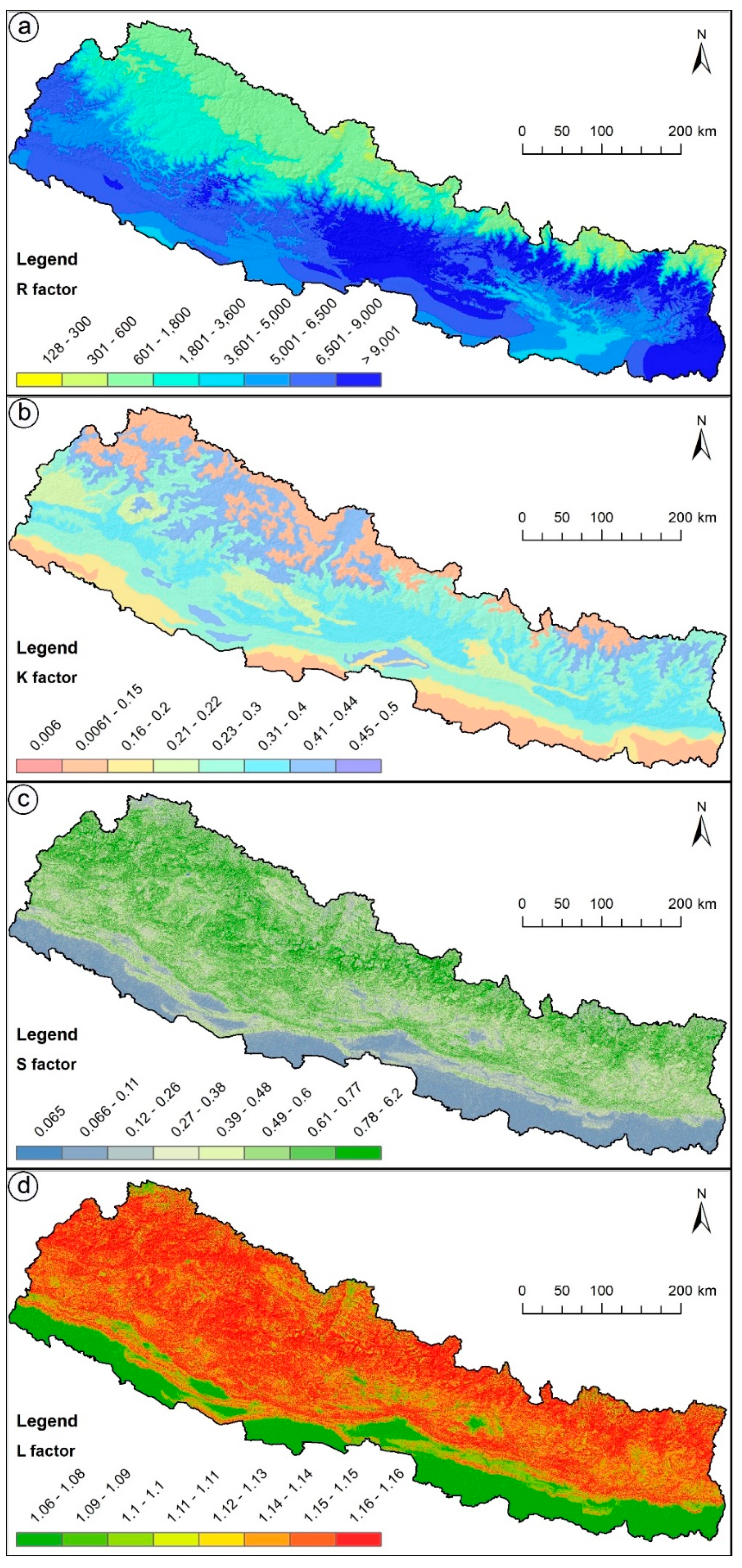
Development of Specific RUSLE Data Layers
Rainfall Erosivity Factor (R)
Soil Erodibility Factor (K)
Slope-Length Factor (L)
Slope-Steepness Factor (S)
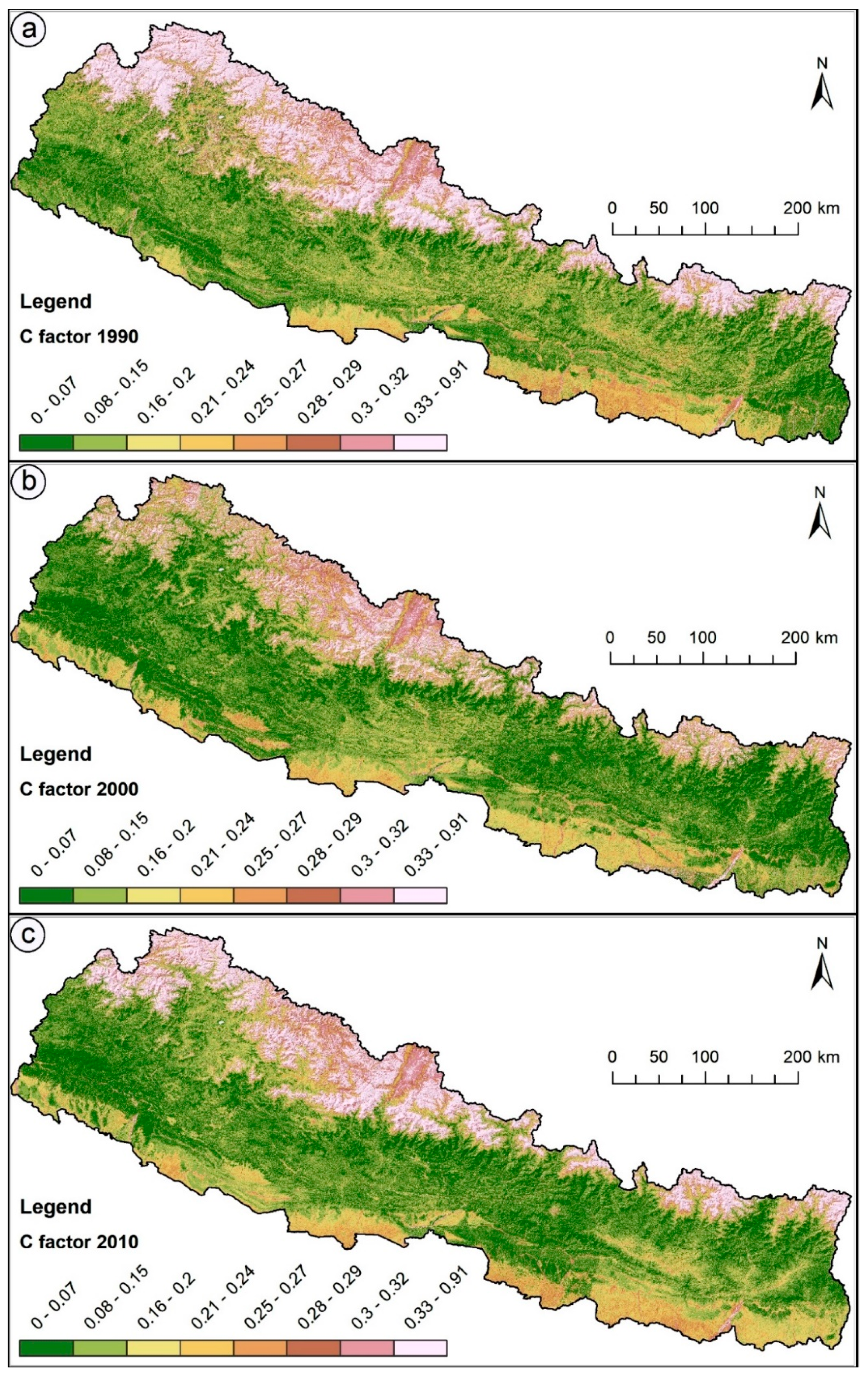
Cover Management Factor (C)
Support Practice Factor (P)
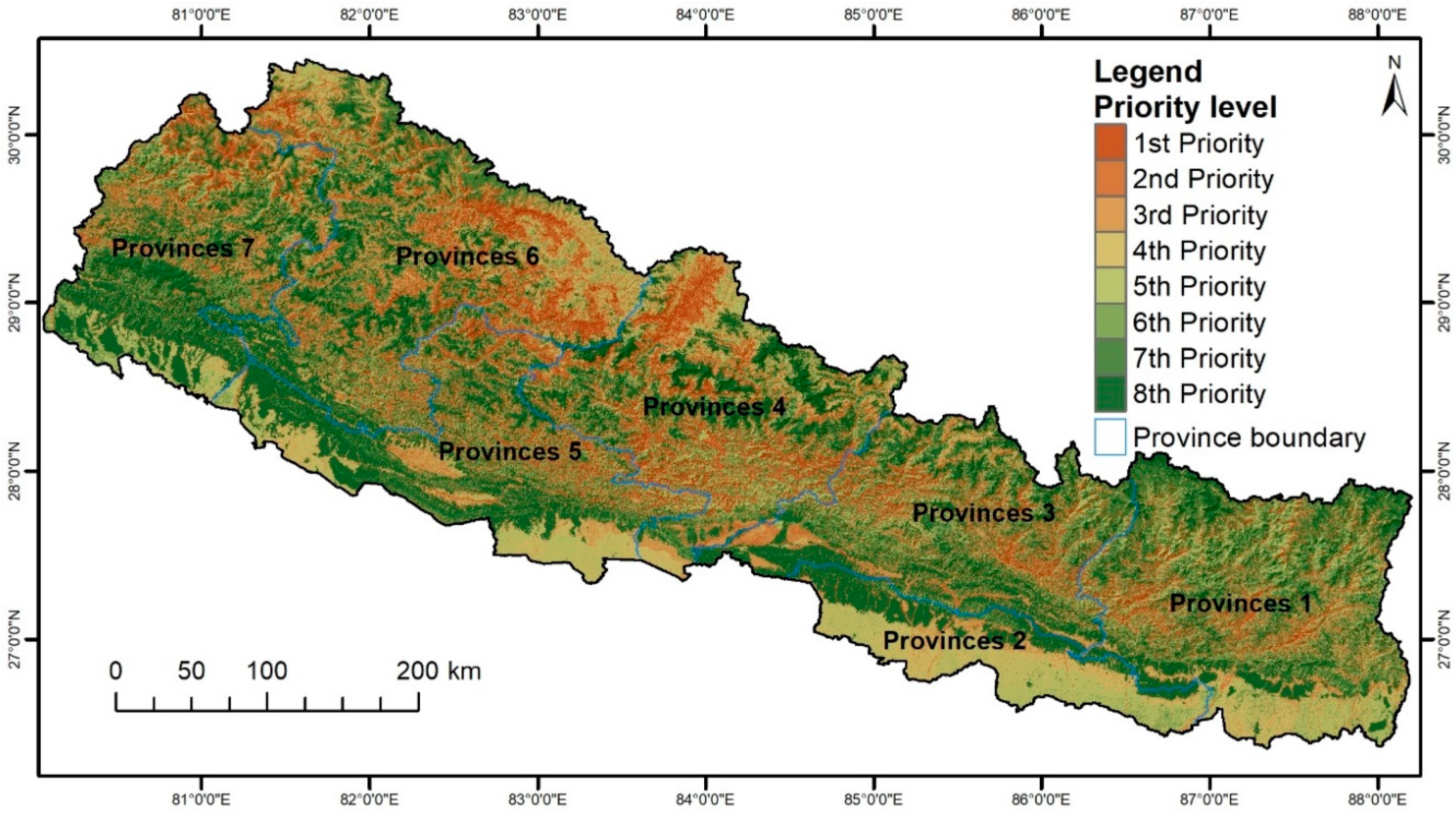
2.4. Determination of Soil Priority Areas
3. Results
4. Discussion
5. Conclusions
Supplementary Materials
Author Contributions
Acknowledgments
Conflicts of Interest
References
- Kidane, D.; Alemu, B. The effect of upstream land use practices on soil erosion and sedimentation in the Upper Blue Nile Basin, Ethiopia. Res. J. Agric. Environ. Manag. 2015, 4, 55–68. [Google Scholar]
- Sharma, A.; Tiwari, K.N.; Bhadoria, P. Effect of land use land cover change on soil erosion potential in an agricultural watershed. Environ. Monit. Assess. 2011, 173, 789–801. [Google Scholar] [CrossRef] [PubMed]
- Ganasri, B.; Ramesh, H. Assessment of soil erosion by RUSLE model using remote sensing and GIS-A case study of Nethravathi Basin. Geosci. Front. 2016, 7, 953–961. [Google Scholar] [CrossRef]
- Bahadur, K.K. Mapping soil erosion susceptibility using remote sensing and GIS: A case of the Upper Nam Wa Watershed, Nan Province, Thailand. Environ. Geol. 2009, 57, 695–705. [Google Scholar] [CrossRef]
- Rawat, K.S.; Mishra, A.K.; Bhattacharyya, R. Soil erosion risk assessment and spatial mapping using LANDSAT-7 ETM+, RUSLE, and GIS—A case study. Arab. J. Geosci. 2016, 9, 288. [Google Scholar] [CrossRef]
- DSCWM. Land Degradation Problems. Available online: http://www.dscwm.gov.np/index.php/land-degradation-problems (accessed on 5 January 2017).
- Alkharabsheh, M.M.; Alexandridis, T.; Bilas, G.; Misopolinos, N.; Silleos, N. Impact of land cover change on soil erosion hazard in northern Jordan using remote sensing and GIS. Procedia Environ. Sci. 2013, 19, 912–921. [Google Scholar] [CrossRef]
- Ives, J.D.; Messerli, B. The Himalayan Dilemma: Reconciling Development and Conservation; Routledge: Abingdon, UK, 1989. [Google Scholar]
- Tadesse, L.; Suryabhagavan, K.; Sridhar, G.; Legesse, G. Land use and land cover changes and Soil erosion in Yezat Watershed, North Western Ethiopia. Int. Soil Water Conserv. Res. 2017, 5, 85–94. [Google Scholar] [CrossRef]
- Abidin, R.Z.; Hassan, Z.A. ‘ROM’ Scale for Forecasting Erosion Induced Landslide Risk on Hilly Terrain. In Landslides; Springer: Berlin, Germany, 2005; pp. 197–202. [Google Scholar]
- Khosrokhani, M.; Pradhan, B. Spatio-temporal assessment of soil erosion at Kuala Lumpur metropolitan city using remote sensing data and GIS. Geomat. Nat. Hazards Risk 2014, 5, 252–270. [Google Scholar] [CrossRef]
- IPCC. Climate change 2007: The physical science basis. Agenda 2007, 6, 333. [Google Scholar]
- Wischmeier, W.H.; Smith, D.D. Predicting Rainfall Erosion Losses: A Guide to Conservation Planning; Science and Education Administration: Washington, DC, USA, 1978; p. 58. [Google Scholar]
- Renard, K.G.; Foster, G.R.; Weesies, G.A.; Porter, J.P. RUSLE: Revised universal soil loss equation. J. Soil Water Conserv. 1991, 46, 30–33. [Google Scholar]
- Perovic, V.; Zivotic, L.; Kadovic, R.; Dordevic, A.; Jaramaz, D.; Mrvic, V.; Todorovic, M. Spatial modelling of soil erosion potential in a mountainous watershed of South-Eastern Serbia. Environ. Earth Sci. 2013, 68, 115–128. [Google Scholar] [CrossRef]
- Shinde, V.; Tiwari, K.; Singh, M. Prioritization of micro watersheds on the basis of soil erosion hazard using remote sensing and geographic information system. Int. J. Water Resour. Environ. Eng. 2010, 5, 130–136. [Google Scholar]
- Uddin, K.; Murthy, M.; Wahid, S.M.; Matin, M.A. Estimation of soil erosion dynamics in the Koshi basin using GIS and remote sensing to assess priority areas for conservation. PLoS ONE 2016, 11, e0150494. [Google Scholar] [CrossRef]
- Uddin, K.; Dhakal, M.; Joshi, G. An Optical High and Medium Spatial Resolution Approach for Erosion-Prone Areas Assessment in Mustang, Nepal. Int. J. Geosci. 2014, 2014, 383–393. [Google Scholar] [CrossRef]
- Sah, B. Watershed Degradation and Its Socio-Economic Impacts Using RS and GIS: A Case Study of Trijuga Watershed, Nepal; NR 96–20. Master’s Thesis, Asian Institute of Technology, Bangkok, Thailand, 1996. [Google Scholar]
- Pandey, A.; Mishra, S.; Gautam, A.K.; Kumar, D. Soil erosion assessment of a Himalayan river basin using TRMM data. Proc. Int. Assoc. Hydrol. Sci. 2015, 366, 200. [Google Scholar] [CrossRef]
- Morgan, R.; Morgan, D.; Finney, H. A predictive model for the assessment of soil erosion risk. J. Agric. Eng. Res. 1984, 30, 245–253. [Google Scholar] [CrossRef]
- Shrestha, D.P. Assessment of soil erosion in the Nepalese Himalaya: A case study in Likhu Khola Valley, Middle Mountain Region. Land Husb. 1997, 2, 59–80. [Google Scholar]
- Jha, M.K.; Paudel, R.C. Erosion Predictions by Empirical Models in a mountainous Watershed in Nepal. J. Spat. Hydrol. (JOSH) 2010, 10, 89–102. [Google Scholar]
- Acharya, A.K.; Kafle, N. Land degradation issues in Nepal and its management through agroforestry. J. Agric. Environ. 2009, 10, 133–143. [Google Scholar] [CrossRef]
- Rijal, S. Soil fertility decline in Nepal: Problem and strategy. Nepal J. Sci. Technol. 2001, 3, 41–46. [Google Scholar]
- Bajracharya, R.M.; Sherchan, D.P. Fertility status and dynamics of soils in the Nepal Himalaya: A review and analysis. Soil Fertil. 2009, 111–135. [Google Scholar]
- Acharya, K.P.; Poudel, B.S.; Dangi, R.B. State of Land Degradation and Rehabilitation Efforts in Nepal. Keep Asia Green 2008, 163–202. [Google Scholar]
- Uddin, K.; Shrestha, H.L.; Murthy, M.; Bajracharya, B.; Shrestha, B.; Gilani, H.; Pradhan, S.; Dangol, B. Development of 2010 national land cover database for the Nepal. J. Environ. Manag. 2015, 148, 82–90. [Google Scholar] [CrossRef] [PubMed]
- Dahal, R.K.; Hasegawa, S. Representative rainfall thresholds for landslides in the Nepal Himalaya. Geomorphology 2008, 100, 429–443. [Google Scholar] [CrossRef]
- National Population and Housing Census. National Population and Housing Census 2011 (Village Development Commiee/Municipality); Statistics, C.B.O., Ed.; Government of Nepal, National Planning Commission Secretariat: Kathmandu, Nepal, 2012.
- Radoux, J.; Bogaert, P.; Fasbender, D.; Defourny, P. Thematic accuracy assessment of geographic object-based image classification. Int. J. Geogr. Inf. Sci. 2011, 25, 895–911. [Google Scholar] [CrossRef]
- Blaschke, T. Object based image analysis for remote sensing. ISPRS J. Photogramm. Remote. Sens. 2010, 65, 2–16. [Google Scholar] [CrossRef]
- Gilani, H.; Shrestha, H.L.; Murthy, M.; Phuntso, P.; Pradhan, S.; Bajracharya, B.; Shrestha, B. Decadal land cover change dynamics in Bhutan. J. Environ. Manag. 2015, 148, 91–100. [Google Scholar] [CrossRef] [PubMed]
- Hay, G.J.; Castilla, G. Geographic object-based image analysis (GEOBIA): A new name for a new discipline. In Object-Based Image Analysis; Blaschke, T., Lang, S., Hay, G., Eds.; Springer: New York, NY, USA, 2008; pp. 75–90. [Google Scholar]
- Hay, G.J.; Blaschke, T.; Marceau, D.J.; Bouchard, A. A comparison of three image-object methods for the multiscale analysis of landscape structure. ISPRS J. Photogramm. Remote Sens. 2003, 57, 327–345. [Google Scholar] [CrossRef]
- Baatz, M.; Fau, A.N.; Fau, S.A.; Fau, B.G.; Bettina, L. Object-oriented image analysis for high content screening: Detailed quantification of cells and sub cellular structures with the Cellenger software. Cytom. Part A 2006, 69, 652–658. [Google Scholar] [CrossRef] [Green Version]
- Bajracharya, B.; Uddin, K.; Chettri, N.; Shrestha, B.; Siddiqui, S.A. Understanding Land Cover Change Using a Harmonized Classification System in the Himalaya. Mt. Res. Dev. 2010, 30, 143–156. [Google Scholar] [CrossRef]
- Chettri, N.; Uddin, K.; Chaudhary, S.; Sharma, E. Linking Spatio-Temporal Land Cover Change to Biodiversity Conservation in the Koshi Tappu Wildlife Reserve, Nepal. Diversity 2013, 5, 335–351. [Google Scholar] [CrossRef] [Green Version]
- Olofsson, P.; Foody, G.M.; Stehman, S.V.; Woodcock, C.E. Making better use of accuracy data in land change studies: Estimating accuracy and area and quantifying uncertainty using stratified estimation. Remote Sens. Environ. 2013, 129, 122–131. [Google Scholar] [CrossRef]
- Olofsson, P.; Foody, G.M.; Herold, M.; Stehman, S.V.; Woodcock, C.E.; Wulder, M.A. Good practices for estimating area and assessing accuracy of land change. Remote Sens. Environ. 2014, 148, 42–57. [Google Scholar] [CrossRef] [Green Version]
- Reed, R.A.; Johnson-Barnard, J.; Baker, W.L. Fragmentation of a forested Rocky Mountain land-scape. Biological Conservation. 1996, 75, 267–269. [Google Scholar] [CrossRef]
- SRTM. Hole-Filled SRTM for the Globe Version 4. The Consultative Group on International Agricultural Research (CGIAR)-SXI SRTM 90 m Database, 2008. Available online: http://srtm.csi.cgiar.org (accessed on 3 February 2018).
- Singh, G.; Chandra, S.; Babu, R. Soil Loss and Prediction Research in India; Bulletin No. T-12/D9; Central Soil and Water Conservation Research Training Institute: Dehradun, India, 1981. [Google Scholar]
- GLOVIS. USGS Global Visualization Viewer (GLOVIS) Earth Resources; Observation and Science Center (EROS): 2008. Available online: http://glovis.usgs.gov/ (accessed on 12 April 2015).
- Renard, K.G.; Foster, G.R.; Weesies, G.A.; McCool, D.K.; Yoder, D.C. Predicting Soil Erosion by Water: A Guide to Conservation Planning with the Revised Universal Soil Loss Equation (RUSLE); United States Department of Agriculture: Washington, DC, USA, 1997; Volume 703.
- Meusburger, K.; Steel, A.; Panagos, P.; Montanarella, L.; Alewell, C. Spatial and temporal variability of rainfall erosivity factor for Switzerland. Hydrol. Earth Syst. Sci. 2012, 16, 167–177. [Google Scholar] [CrossRef] [Green Version]
- Fick, S.E.; Hijmans, R.J. WorldClim 2: New 1-km spatial resolution climate surfaces for global land areas. Int. J. Climatol. 2017, 37, 4302–4315. [Google Scholar] [CrossRef]
- McGarigal, K. Landscape pattern metrics. Encycl. Environ. 2002, 2. [Google Scholar] [CrossRef]
- Panagos, P.; Meusburger, K.; Alewell, C.; Montanarella, L. Soil erodibility estimation using LUCAS point survey data of Europe. Environ. Model. Softw. 2012, 30, 143–145. [Google Scholar] [CrossRef]
- Franklin, S.E. Remote Sensing for Sustainable Forest Management; Lewis Publishers: Boca Raton, FL, USA, 2001. [Google Scholar]
- Gardner, R.A.M.; Gerrard, A.J. Runoff and soil erosion on cultivated rainfed terraces in the Middle Hills of Nepal. Appl. Geogr. 2003, 23, 23–45. [Google Scholar] [CrossRef]
- Khosrowpanah, S.; Heitz, L.; Wen, Y.; Park, M. Developing a GIS-Based Soil Erosion Potential Model of the UGUM Watershed; Water and Environmental Research Institute of the Western Pacific, University of Guam: Mangilao, Guam, 2007.
- Jain, S.K.; Kumar, S.; Varghese, J. Estimation of Soil Erosion for a Himalayan Watershed Using GIS Technique. Water Resour. Manag. 2001, 15, 41–54. [Google Scholar] [CrossRef]
- Mandal, D.; Sharda, V.N. Appraisal of soil erosion risk in the eastern himalayan region of india for soil conservation planning. Land Degrad. Dev. 2013, 24, 430–437. [Google Scholar] [CrossRef]
- Van der Knijff, J.; Jones, R.; Montanarella, L. Soil Erosion Risk Assessment in Italy; European Soil Bureau, European Commission: Brussels, Belgium, 1999; p. 51. [Google Scholar]
- De Jong, S.M. Derivation of vegetative variables from a Landsat TM image for modelling soil erosion. Earth Surf. Process. Landf. 1994, 19, 165–178. [Google Scholar] [CrossRef]
- Prasannakumar, V.; Vijith, H.; Abinod, S.; Geetha, N. Estimation of soil erosion risk within a small mountainous sub-watershed in Kerala, India, using Revised Universal Soil Loss Equation (RUSLE) and geo-information technology. Geosci. Front. 2012, 3, 209–215. [Google Scholar] [CrossRef]
- Sonneveld, B.; Nearing, M. A nonparametric/parametric analysis of the Universal Soil Loss Equation. Catena 2003, 52, 9–21. [Google Scholar] [CrossRef] [Green Version]
- Wang, G.; Gertner, G.; Parysow, P.; Anderson, A. Spatial prediction and uncertainty analysis of topographic factors for the revised universal soil loss equation (RUSLE). J. Soil Water Conserv. 2000, 55, 374–384. [Google Scholar]
- Dissmeyer, G.E.; Foster, G.R. Estimating the cover-management factor (C) in the universal soil loss equation for forest conditions. J. Soil Water Conserv. 1981, 36, 235–240. [Google Scholar]
- DFRS. Forest Resources of Nepal (1987–1998); Department of Forest Research and Survey, Ministry of Forest and Soil Conservation: Kathmandu, Nepal, 1999.
- Shrestha, S.M.; Shakya, C.-O.R.; Thapa, M.H.B.; Ojha, M.S.K.; Malla, R. Banko Janakari. In A Journal of Forestry Information for Nepal; Department of Forest Research and Survey (DFRS), Ministry of Forests and Soil Conservation, Government of Nepal: Kathmandu, Nepal, 2009; Volume 19, p. 44. [Google Scholar]
- DFRS. State of Nepal’s Forests. Forest Resource Assessment (FRA) Nepal; Department of Forest Research and Survey (DFRS): Kathmandu, Nepal, 2015.
- Rukhovich, D.; Wagner, V.; Vil’chevskaya, E.; Kalinina, N.; Koroleva, P. Problems of using digitized thematic maps on the territory of the former Soviet Union upon the creation of the “Soils of Russia” geographic information system. Eurasian Soil Sci. 2011, 44, 957. [Google Scholar] [CrossRef]
- Frith, M.W. Measuring Error in Manually Digitized Maps; University of Regina: Regina, SK, Canada, 1999. [Google Scholar]
- Chen, G.; Weng, Q.; Hay, G.J.; He, Y. Geographic object-based image analysis (GEOBIA): Emerging trends and future opportunities. GISci. Remote Sens. 2018, 55, 159–182. [Google Scholar] [CrossRef]
- Costa, H.; Foody, G.M.; Boyd, D.S. Supervised methods of image segmentation accuracy assessment in land cover mapping. Remote Sens. Environ. 2018, 205, 338–351. [Google Scholar] [CrossRef]
- Keenan, R.J.; Reams, G.A.; Achard, F.; de Freitas, J.V.; Grainger, A.; Lindquist, E. Dynamics of global forest area: Results from the FAO Global Forest Resources Assessment 2015. For. Ecol. Manag. 2015, 352, 9–20. [Google Scholar] [CrossRef]
- Ozsahin, E.; Duru, U.; Eroglu, I. Land Use and Land Cover Changes (LULCC), a Key to Understand Soil Erosion Intensities in the Maritsa Basin. Water 2018, 10, 335. [Google Scholar] [CrossRef]
- Luleva, M.I.; Van Der Werff, H.; Van Der Meer, F.; Jetten, V. Gaps and opportunities in the use of remote sensing for soil erosion assessment. Chemistry 2012, 21, 748–764. [Google Scholar]
- Mandal, U.K. Geo-information-Based Soil Erosion Modeling for Sustainable Agriculture Development in Khadokhola Watershed, Nepal. In Land Cover Change and Its Eco-Environmental Responses in Nepal; Springer: Singapore, 2017; pp. 223–241. [Google Scholar]
- Kavian, A.; Hoseinpoor Sabet, S.; Solaimani, K.; Jafari, B. Simulating the effects of land use changes on soil erosion using RUSLE model. Geocarto Int. 2017, 32, 97–111. [Google Scholar] [CrossRef]
- Nayak, T.; Jaiswal, R.; Galkate, R.; Thomas, T. Impact Assessment of Alternate Land Cover and Management Practices on Soil Erosion: A Case Study. In Hydrologic Modeling; Springer: Singapore, 2018; pp. 211–223. [Google Scholar]
- Kc, B.; Wang, T.; Gentle, P. Internal Migration and Land Use and Land Cover Changes in the Middle Mountains of Nepal. Mt. Res. Dev. 2017, 37, 446–455. [Google Scholar] [CrossRef] [Green Version]
- Anup, K.; Bhandari, G.; Joshi, G.R.; Aryal, S. Climate Change Mitigation Potential from Carbon Sequestration of Community Forest in Mid Hill Region of Nepal. Int. J. Environ. Prot. 2013, 3, 33–40. [Google Scholar]
- Dahal, G.R.; Adhikari, K.; Thwaites, R. Forest tenure and community forestry in Nepal: Trends and implications. In Community Forestry in Nepal; Routledge: Abingdon, UK, 2017; pp. 132–150. [Google Scholar]
- Fisher, R.; Shrestha, K. Labour migration, the remittance economy and the changing context of community forestry in Nepal. In Community Forestry in Nepal; Routledge: Abingdon, UK, 2017; pp. 171–192. [Google Scholar]


| Soil Erosion Factor | Input Data | Data Source | Equation or Published Factor |
|---|---|---|---|
| Rainfall erosivity factor (R) | Precipitation (ESRI grids, 10 arc-minutes) | World climate precipitation data [41] | R = 0.0483 × P1.610 where P = annual precipitation (mm) |
| Soil erodibility factor (K) | Soil maps from Nepal | Literature review | |
| Slope length factor (L) | SRTM 30 m digital elevation data | [42] | L = (λ/22.13) m where λ is the field slope length (m), and m assumes a value from 0.2 to 0.5 [43] |
| Slope steepness factor (S) | SRTM 30m digital elevation data | [42] | S = (0.43 + 0.30 s + 0.043 s2)/6.613 [13] |
| Land cover management factor (C) | NDVI from Landsat | [44] | C = 0.431 − 0.805 x NDVI [45] |
| Support practice factor (P) | Land cover map | ICIMOD ([28] | Literature review |
| Slope Gradient | Value of m |
|---|---|
| 1% | 0.2 |
| 1–3% | 0.3 |
| 3–4.5% | 0.4 |
| 4.5% or more | 0.5 |
| Land Cover | Land Cover Area (ha) | Annual Soil Loss (t) | Mean Erosion Rate (t/ha/yr) | ||||||
|---|---|---|---|---|---|---|---|---|---|
| Year | 1990 | 2000 | 2010 | 1990 | 2000 | 2010 | 1990 | 2000 | 2010 |
| Forest | 6,668,336 | 6,148,401 | 6,202,809 | 9,557,443 | 4,968,762 | 5,488,194 | 1.43 | 0.81 | 0.88 |
| Shrubland | 328,142 | 346,930 | 342,986 | 1,223,757 | 849,352 | 1,449,670 | 3.73 | 2.45 | 4.23 |
| Grassland | 1,728,561 | 1,379,485 | 1,264,552 | 25,198,391 | 13,941,821 | 13,982,884 | 14.58 | 10.11 | 11.06 |
| Agriculture area | 3,753,933 | 4,096,968 | 4,039,820 | 69,054,803 | 36,115,163 | 60,071,672 | 18.40 | 8.82 | 14.87 |
| Barren area | 1,006,831 | 1,702,002 | 1,535,851 | 21,299,992 | 38,469,816 | 23,266,676 | 21.16 | 22.60 | 15.15 |
| Water body | 81,052 | 73,051 | 72,685 | 2,029,087 | 1,608,671 | 1,597,417 | 25.03 | 22.02 | 21.98 |
| Snow/glacier | 1,168,741 | 974,176 | 1,255,347 | 919,372 | 682,081 | 4,537,558 | 0.79 | 0.70 | 3.61 |
| Built-up area | 32,916 | 47,499 | 54,462 | 33,952 | 39,974 | 152,439 | 1.03 | 0.84 | 2.80 |
| Total | 14,768,512 | 14,768,512 | 14,768,512 | 129,316,796 | 96,675,641 | 110,546,509 | 8.76 | 6.55 | 7.49 |
| Soil Erosion Risk Rank (t/ha/yr) | Very Low (<0.5) | Low (0.5–1) | Low Medium (1–2) | Medium (2–5) | High Medium (5–10) | High (10–20) | Very High (20–50) | Extremely High (>50) | Total 2000 |
|---|---|---|---|---|---|---|---|---|---|
| Very low (<0.5) | 29.56 | 5.62 | 2.59 | 0.63 | 0.80 | 0.60 | 0.39 | 0.08 | 40.27 |
| Low (0.5–1) | 1.44 | 2.68 | 3.29 | 0.37 | 0.19 | 0.11 | 0.08 | 0.02 | 8.18 |
| Low medium (1–2) | 1.50 | 0.92 | 6.01 | 4.11 | 1.73 | 0.55 | 0.32 | 0.06 | 15.20 |
| Medium (2–5) | 1.03 | 0.21 | 0.80 | 1.28 | 2.17 | 1.04 | 0.42 | 0.06 | 7.00 |
| High medium (5–10) | 1.38 | 0.40 | 0.75 | 0.50 | 2.57 | 3.02 | 1.79 | 0.19 | 10.61 |
| High (10–20) | 0.90 | 0.35 | 0.42 | 0.39 | 0.74 | 2.64 | 3.54 | 0.64 | 9.63 |
| Very high (20–50) | 0.59 | 0.09 | 0.32 | 0.08 | 0.42 | 0.95 | 2.91 | 1.81 | 7.16 |
| Extremely high (>50) | 0.19 | 0.01 | 0.05 | 0.03 | 0.02 | 0.15 | 0.52 | 0.98 | 1.95 |
| Total 1990 | 36.57 | 10.27 | 14.24 | 7.40 | 8.66 | 9.06 | 9.97 | 3.84 | 100 |
| Soil Erosion Risk Rank (t/ha/yr) | Very Low (<0.5) | Low (0.5–1) | Low Medium (1–2) | Medium (2–5) | High Medium (5–10) | High (10–20) | Very High (20–50) | Extremely High (>50) | Total 2010 |
|---|---|---|---|---|---|---|---|---|---|
| Very low (<0.5) | 32.44 | 2.23 | 1.64 | 1.08 | 1.55 | 1.02 | 0.63 | 0.19 | 40.79 |
| Low (0.5–1) | 3.87 | 3.16 | 1.19 | 0.16 | 0.31 | 0.37 | 0.16 | 0.01 | 9.23 |
| Low medium (1–2) | 1.49 | 2.03 | 5.11 | 0.61 | 0.68 | 0.33 | 0.26 | 0.06 | 10.57 |
| Medium (2–5) | 0.68 | 0.34 | 4.34 | 1.30 | 0.51 | 0.46 | 0.08 | 0.02 | 7.72 |
| High medium (5–10) | 0.83 | 0.22 | 2.08 | 2.60 | 2.97 | 0.91 | 0.56 | 0.02 | 10.20 |
| High (10–20) | 0.57 | 0.11 | 0.48 | 0.89 | 3.30 | 3.23 | 1.16 | 0.22 | 9.94 |
| Very high (20–50) | 0.32 | 0.07 | 0.31 | 0.32 | 1.17 | 3.02 | 3.24 | 0.55 | 9.00 |
| Extremely high (>50) | 0.06 | 0.01 | 0.05 | 0.05 | 0.12 | 0.30 | 1.09 | 0.87 | 2.55 |
| Total 2010 | 40.27 | 8.18 | 15.20 | 7.00 | 10.61 | 9.63 | 7.16 | 1.95 | 100 |
© 2018 by the authors. Licensee MDPI, Basel, Switzerland. This article is an open access article distributed under the terms and conditions of the Creative Commons Attribution (CC BY) license (http://creativecommons.org/licenses/by/4.0/).
Share and Cite
Uddin, K.; Abdul Matin, M.; Maharjan, S. Assessment of Land Cover Change and Its Impact on Changes in Soil Erosion Risk in Nepal. Sustainability 2018, 10, 4715. https://doi.org/10.3390/su10124715
Uddin K, Abdul Matin M, Maharjan S. Assessment of Land Cover Change and Its Impact on Changes in Soil Erosion Risk in Nepal. Sustainability. 2018; 10(12):4715. https://doi.org/10.3390/su10124715
Chicago/Turabian StyleUddin, Kabir, Mir Abdul Matin, and Sajana Maharjan. 2018. "Assessment of Land Cover Change and Its Impact on Changes in Soil Erosion Risk in Nepal" Sustainability 10, no. 12: 4715. https://doi.org/10.3390/su10124715
APA StyleUddin, K., Abdul Matin, M., & Maharjan, S. (2018). Assessment of Land Cover Change and Its Impact on Changes in Soil Erosion Risk in Nepal. Sustainability, 10(12), 4715. https://doi.org/10.3390/su10124715