1. Introduction
Currently, fragmentation has become a global issue, and anthropogenic activities are considered to be the main cause, especially for the loss of connectivity between different habitats [
1]. With the rapid development of the economy, the construction of roads is considered to be one of the main reasons for biodiversity loss, and it is also known as a barrier for wildlife movements [
2,
3]. It has been reported that the mean road density of the United States is 0.75 km/km
2; for Germany, France, and England it is >1.88 km/km
2; and for Japan it is >3 km/km
2 [
4]. Therefore, road construction has become a global problem affecting the environment.
Roads play an important role in socio-economic development, such as connecting geographical space and human socio-economic activities, promoting local economic development, and growing social wealth. However, they also have a direct or indirect effect on the ecosystem, causing various adverse effects on natural landscapes [
5]. The effect of roads is reflected by the fragmentation of wildlife habitats [
6,
7,
8], which disrupts the horizontal ecological flow, leading to a series of changes in the ecological processes that affect and alter the structure and process of ecosystems [
9].
Similarly, the road type, width [
10], and fence [
11], and their mixed effect might result in a fragmented wildlife habitat, disconnected wildlife, and, most critically, isolated populations. It has been shown that the width of the road affects the number of wildlife that pass over the road [
12]. Furthermore, a road fence might isolate individuals of the same species, or even trap them within the fenced corridor [
13,
14]. Moreover, during the movement of wildlife, high-speed and high-volume traffic would increase the mortality of small and medium body-sized animals and would fragment the habitat of large animals.
Several studies have shown that the construction of lines and strips (e.g., railways and expressways), and areas affected by roads, named ‘road-effect zones’, might affect land use, soil erosion, vegetation, landscape pattern, habitat or landscape connectivity, ecological risk, animal migration, wildlife corridor, and ecosystems. They can serve as obstacles to separate different parts of landscape, acting as a barrier and filter for wildlife [
3,
15]. They are also important as wildlife corridors to connect natural areas, allowing wildlife movement, although this depends significantly on the width of the undisturbed native vegetation along the verges.
In the process of protecting the wildlife, the establishment of national parks and conservation reserves is an important means to protect the remaining habitats of wildlife, and are important for the native flora and fauna. Currently, the number of national parks in the United States, Canada, New Zealand, and Australia is 55, 39, 14, and 516, respectively. By the end of 2016, the number of national nature reserves in China was 447, which are separated from each other, and the species in them are also isolated. The islanding phenomenon has become increasingly apparent, leading to a decrease in the species migration rate and an increase in mortality, and consequently, there has been an overall reduction of biology. Therefore, it is commonly believed that the establishment of ecological corridors between nature reserves can connect isolated habitats and reduce the rate of species extinction. Several studies have shown that the paths for wildlife movement can be defined as ecological corridors [
16]. There are various benefits of building ecological corridors; for example, protecting the diversity of species, diffusing the animals [
17], increasing the exchange of genes, and reducing the risk of extinction [
18]. An ecological corridor is the key to the movement and reproduction of wildlife [
19]. Whereas other studies have argued that an ecological corridor might provide a channel for the spread of harmful organisms, which is a disadvantage to the survival and spread of the target animals [
20]. It also provides a convenient channel for invasive species, predators, pests, and diseases, which could not have spread originally [
21]. Furthermore, it can also increase the rate of invasion.
In studies on the identification of the ecological corridor, the theories of island biology and meta-population have usually been suggested as the theoretical foundation. The structure of the ecological corridor refers to the combination of number, background, width, degree of connectivity, composition, and characteristics of key points [
22]. Forman (1995) suggested that corridors can be the habitat of the wildlife, and they can act as a channel, source, sink, obstruction, and filter for biological movement [
23].
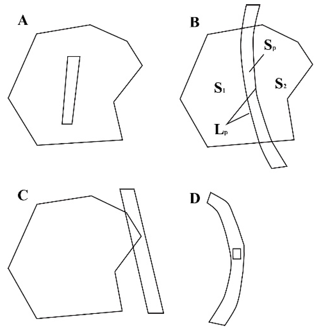
The methods of ecological corridor identification include field observation, a combination of remote sensing (RS) and geographic information system (GIS), reference quantitative research method of landscape pattern, and ecological security [
24]. With the development of RS technology, the combination of RS and GIS methods, and the use of the minimum consumption model (least-cost path analysis [LCP]) to quantitatively study the ecological corridor are widely used in corridor identification, ecological network construction, and species management. Among them, the minimum cumulative resistance (MCR) model is a derivation model of the distance-consuming model, which has practical significance in dealing with ecological and geographic factors, and can solve several problems related to the path. In the application of a concrete model, problems such as source patches and resistance surface should be considered. Studies on the ecological corridor have put forward the principle and procedure of corridor design for corridor management, transforming it from theoretical research to a practical application development [
25].
Currently, the national highway network approximately 400,000 km in length consists of national highways and ordinary national roads. There are 36 national highways with a total length of 118,000 km, and 200 ordinary national roads with a total length of 265,000 km. Under different administrative standards, the government has different emphases and solutions on road construction in China. The national scale road network planning focuses on the rational layout of road network construction, functional integrity, extensive coverage, and safety reliability [
26]. The goal is to achieve high connectivity among core cities, provincial multi-line connectivity, high-speed access to cities and counties, and county–state road coverage. Road construction should consider environmental protection, fully making use of existing routes and avoiding environmentally sensitive areas and ecologically fragile areas.
Road network planning at the scale of provincial and autonomous regions focuses on the establishment of a comprehensive transport system in the region, including a rural road network, urban transport network, and freight logistics network [
27]. The goal is to continuously improve and guarantee the economic development of the region, improve the access rate to township and administrative villages, implement processes mainly through the use of existing routes, and implement greening or engineering facilities to eliminate road damage to natural landscapes.
The construction of the road network from the perspective of the local government is to develop an agriculture infrastructure and rural economy. The aim is to satisfy the demands of the local residents, and also to ensure the improvement of rural economic activities and the normal operation of agricultural production. Because of the lack of upper road network planning, the road network construction affects the ecological environment, with pollution damaging the natural environment during the construction and destruction of highways surrounding the ecosystems.
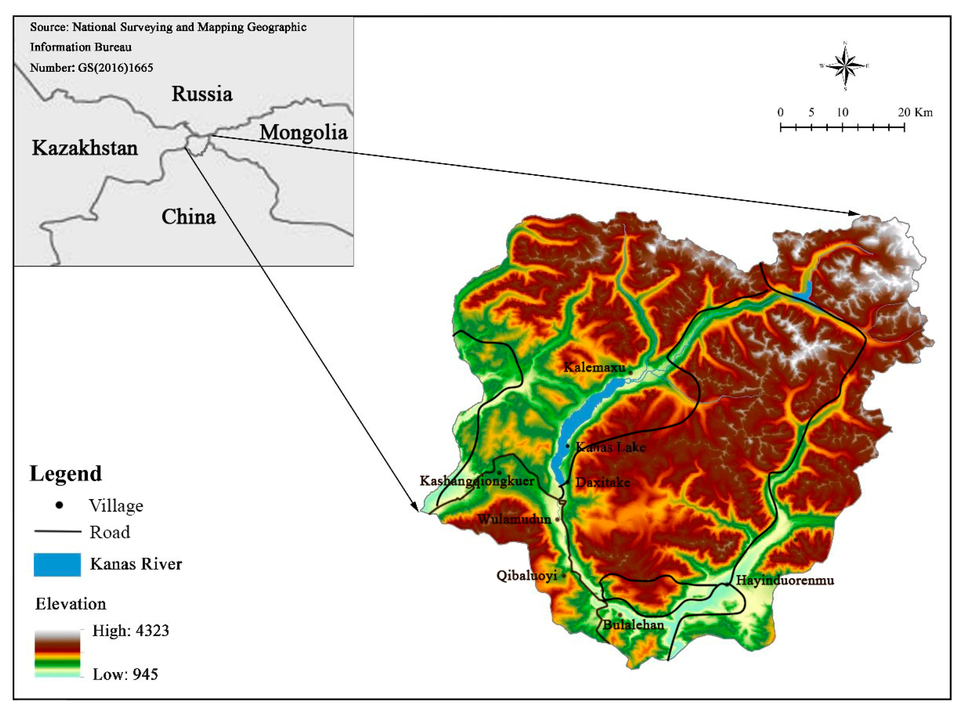
The construction of roads in Kanas is done by the local government. During the late 1990s, as there was an increase in the number of tourists, the local government and the Government of Xinjiang Uygur Autonomous Region increased the funding for the construction of a tourist transportation system to Kanas. Since then, the construction of highways among some villages had been completed. The construction of these highways is of great convenience for tourists to access the scenic spots and has spurred a significant increase in the number of tourists visiting Kanas, thereby, improving the income level of the local residents. However, highway construction has destroyed the integrity of the elite scenery of Kanas, generating an intensive splitting effect on the landscape, and splitting the natural habitats into isolated blocks, forming biological isolated islands, resulting in fragile ecological environment, which might lead to new geological disasters or potential hazards. In this milieu, it is particularly necessary to establish ecological corridors to connect the isolated habitats.
In the present study, we evaluated the effect of roads on the ecological corridors for wildlife movement in Kanas. We attempted to (1) explore the cutting effect of ‘road-zones effect’ on the Kanas landscape; (2) establish the ecological corridor for wildlife movement using the MCR model; and (3) detect the relationship between the changes in the ecological corridor and the road cutting effect, and the geometric characteristics of the road and terrain, in order to enrich and expand the research methods to assess the influence of roads on ecological corridors and to offer suggestions for the construction of a transportation system for the future, in order to reduce the disturbance to the wildlife.
4. Discussion and Conclusions
4.1. Cutting Effect of Road on Landscape
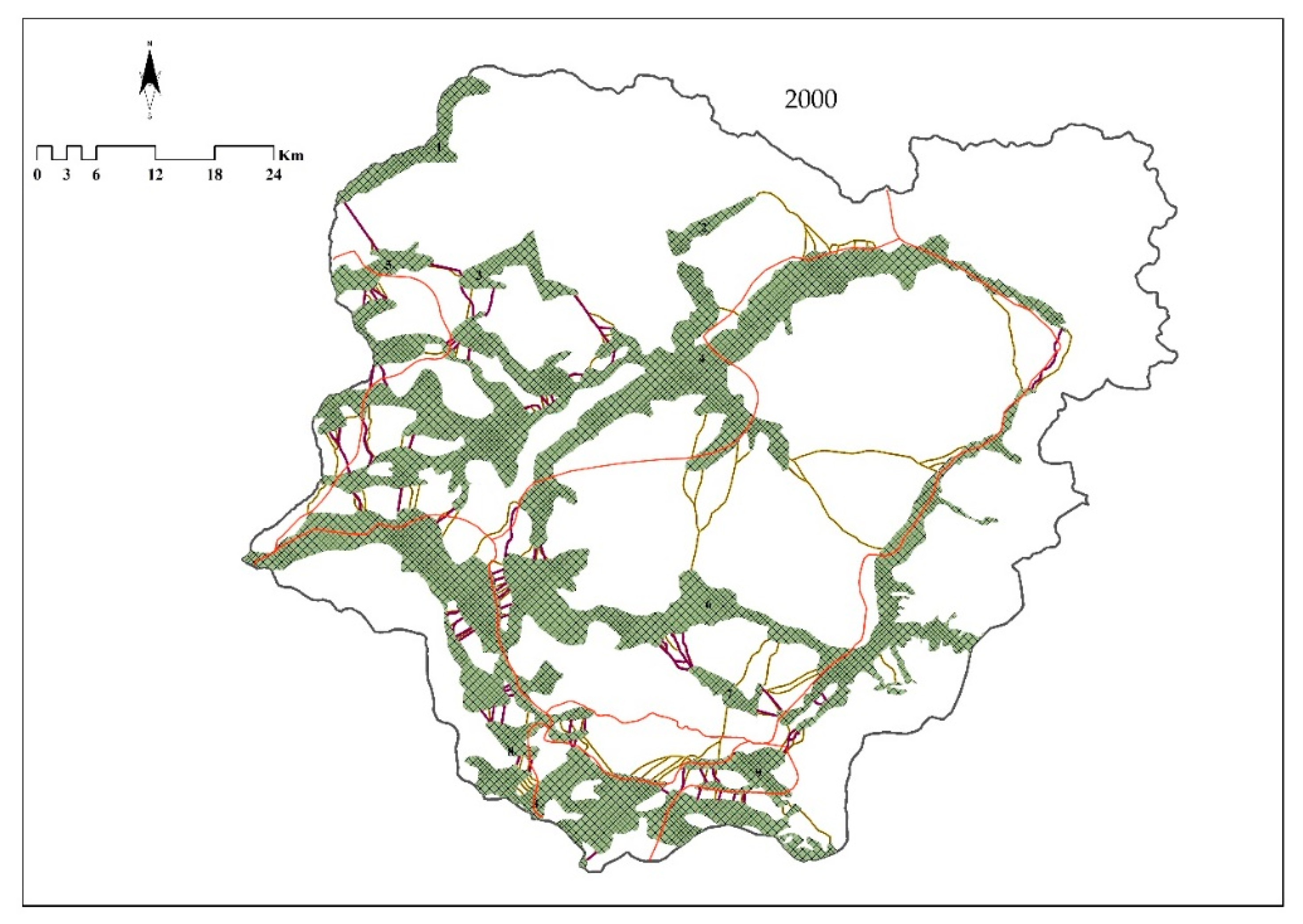
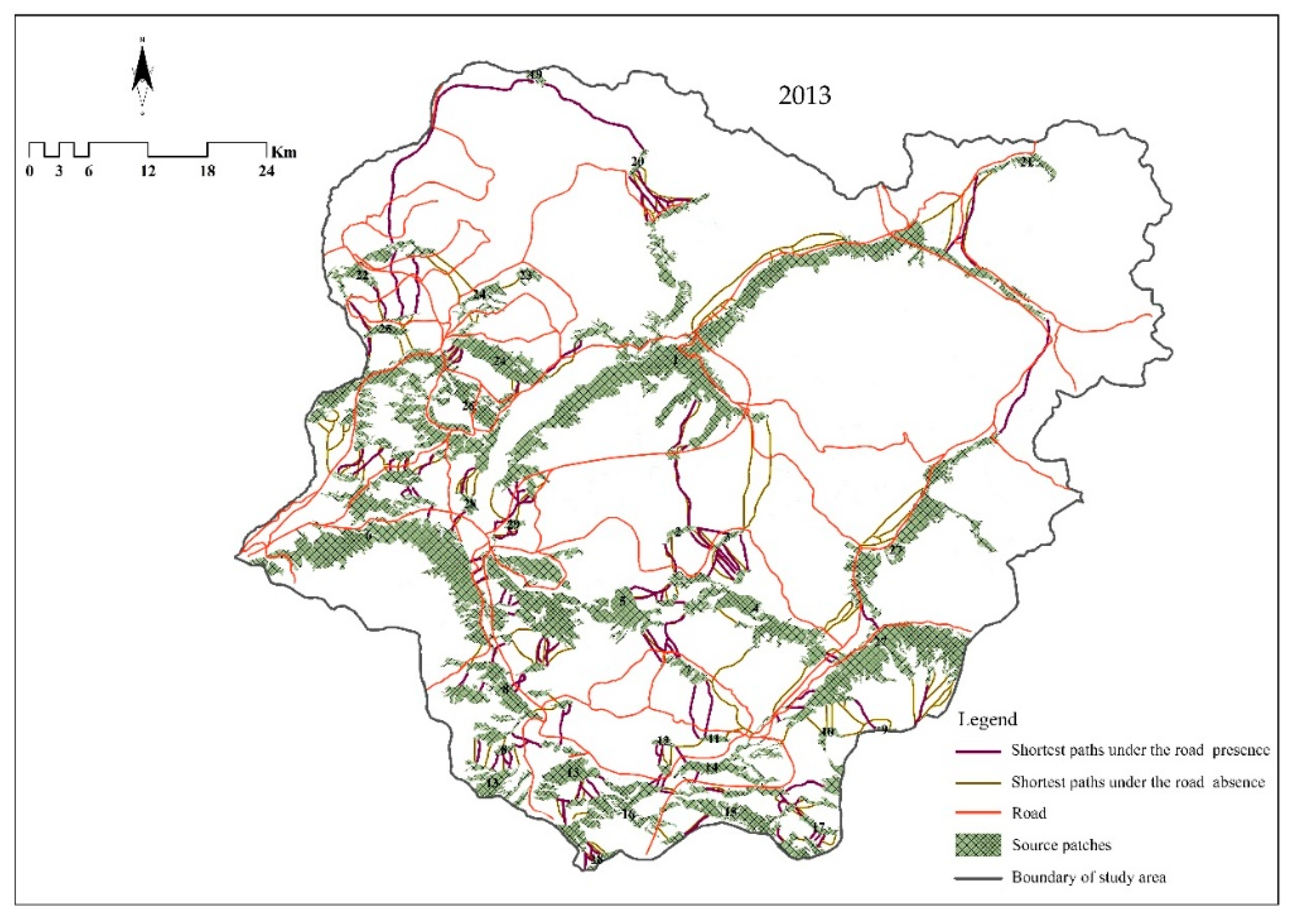
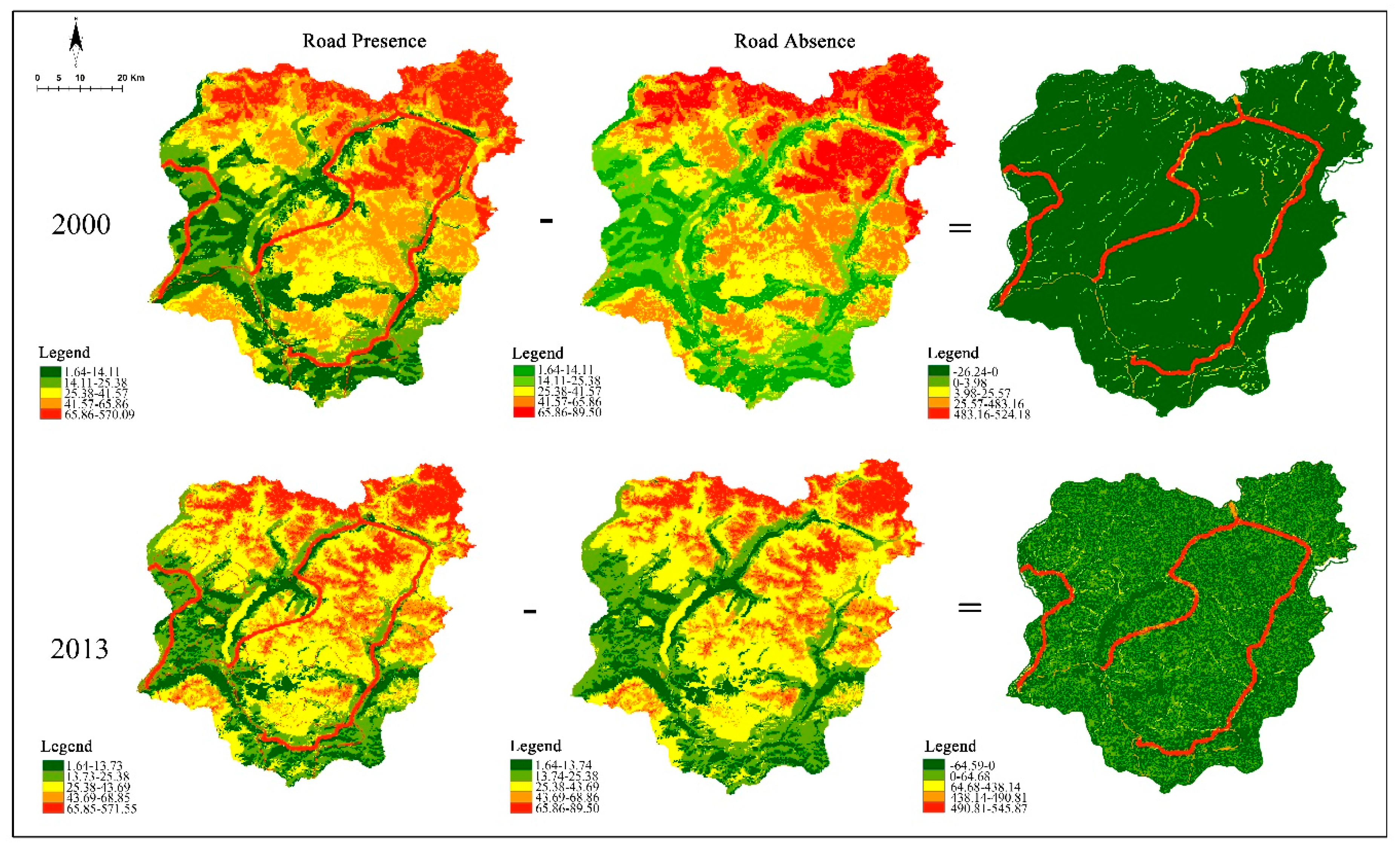
Roads as lines and strips have an obvious cutting effect on the landscape, cutting the entire landscape into isolated patches, causing the fragmentation of landscape, isolation of wildlife, and formation of an island, which can decrease biodiversity. In the zone of ‘road-effect zones’, the landscape type had changed in 2000 and 2013. Beach land and construction land landscapes appeared, and the glacier type landscape disappeared. This is related to anthropogenic activity and climate change. During 2000–2013, the cutting landscape of road construction presented the largest landscape area with an intermediate cutting effect, indicating that ‘road-effect zones’ can produce a large median cutting effect on landscape along the route.
The intermediate cutting effect has the highest influence on grassland and woodland, indicating that it is highly important to protect the grassland and woodland in the environment around the road. As the forestland and grassland are the matrix landscape type of the heritage site, the middle cutting of the patches will hinder the ecological flow within the patches, aggravating the degree of fragmentation of the wildlife habitat and affecting the spread and movement of the wildlife at the individual or population level. The effects of the edge cutting, middle cutting, and complete cutting increase the proportion of the edges and the level of fragmentation of the habitats, affecting the quality of the habitats of wild animals and plants, ecosystems, and landscape patterns in the forestland and grassland, as well as the functioning of ecosystems.
4.2. Methodology of Ecological Corridor for Wildlife Movement
The theories of island biology and meta-population are the basic theories of ecological corridor research. The former suggests that the extinction of wildlife increases if the patch size decreases or the distance increases. Therefore, the diversity of the species would decrease with the cutting effect of roads, increasing the level of fragmentation and the distance of the patch. The latter theory argues that the meta-population is a system of patch populations that consist of two or more sub or local populations, and they are isolated by space, but connected in function. Therefore, increasing the ecological corridors between the fragmentation patch or nature conservation will provide a good channel to find the most suitable habitat for the spread of wildlife, which are isolated from each other because of fragmentation.
Studies on the effect of roads on wildlife movement started in the 1960s, and they mainly focused on the effect of roads on the biological and physical environment [
3]. These studies also assessed the influence of geometrical characteristics, including the road type, quantity, traffic volume, speed, and road fence construction, on brown bears, wolves, and other wild animals. In China, studies began to pay attention to the influence of roads on the landscape pattern, land use, and ecological carrying capacity in the 1990s [
51,
52]. Furthermore, studies on the influence of roads on wildlife have mainly focused on pandas and Asian elephants; in-depth studies on other wildlife are limited.
One of the widely applied models, while choosing a method to build corridors, is the minimum cost model. The least resistance model (as the derivative model of minimum cost model) is often used to build corridors in China. Although the aim of building corridors is similar between China and other countries, that is, to act as a bridge to connect the broken habitat and protect the diversity of wild animals, there are still some differences. The aim of building corridors in other countries is to protect the habitat of specific wildlife. While building corridors, attention would be paid to the genetic characteristics of wildlife, and the source of the corridors is determined by assessing the habitat suitability; food sources, water location, terrain, and other factors are also considered. Whereas studies in China have mainly focused on the regional scale ecological network building and connectivity of a network; for example, they build ecological corridors by studying the habitat suitability of the panda and Asian elephant. However, the Government of China has great executive power and can complete the construction of a biological corridor through policy-oriented mechanism in a short time.
Currently, there are a few studies on the management of biological corridors in China and other countries, and most of them focus on the government’s legal and policy management [
53]; a few studies have been conducted with interest in the community residents. Through the study of the corridors of wolves and other wildlife, between Algonquin Park and Adirondack Park in New York, Brown and Harris (2005) [
54] found that most people do not trust corridor binding, and only a few people showed interest in corridor planning. In China, the residents are concerned that the construction of Asian elephant corridors would result in the entry of wild Asian elephants into villages or farmland, which would affect the production, life, and even threaten their safety [
55].
4.3. Ecological Corridor for Wildlife Movement
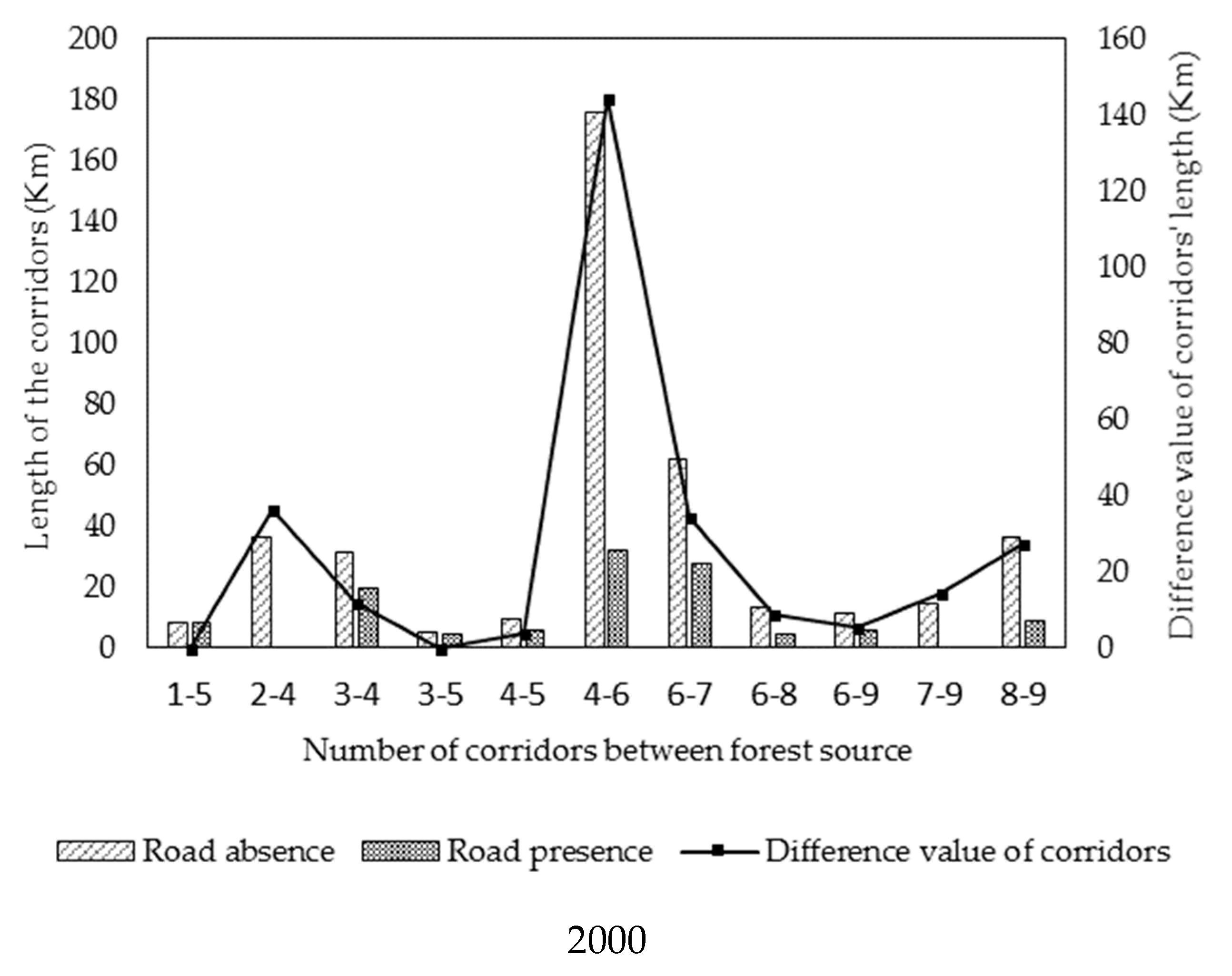
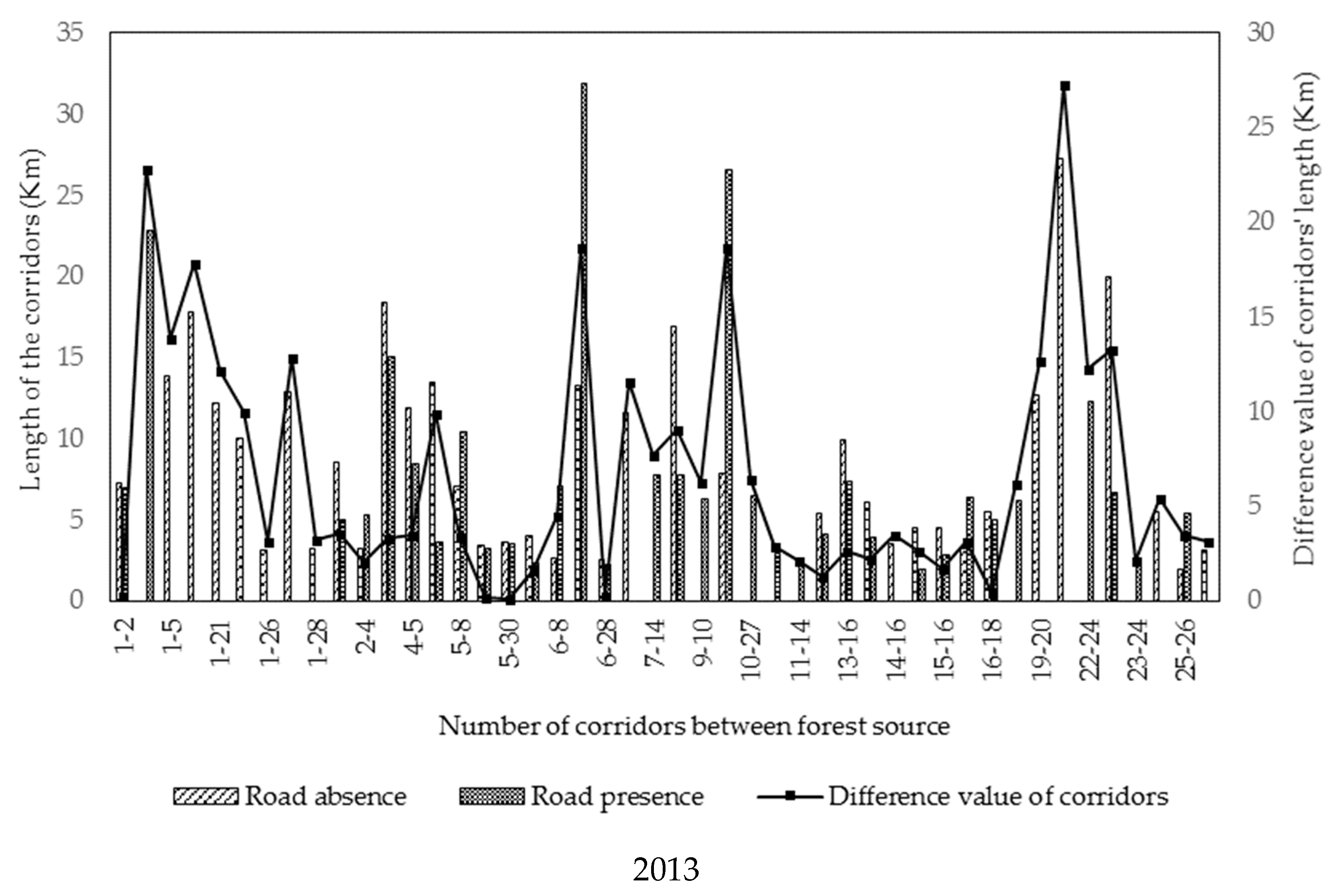
Roads make it more difficult for wildlife to move and spread in the corridors between two patches, and they also lower the inter-patch connectivity and the possibility of species flow, causing the disappearance of some ecological corridors between source patches. Because of the barrier of roads, there will also be new ecological corridors due to the selective detour of wild animals [
28,
56].
It has been suggested that more ecological corridors would be better to meet the requirements of ecological functional. The number of corridors between the patches represent the level of interaction between the patches, and the presence of more inter-patch corridors is conducive to the enhancement of the connectivity between the patches, and thus the migration of the species among the patches. In the future, the suitability of habitats in ecosystem protection can be improved by enhancing the connectivity between patches [
3,
57].
4.4. The Relationship among CCI, Road Geomatic, and Terrain for the Change of Ecological Corridor
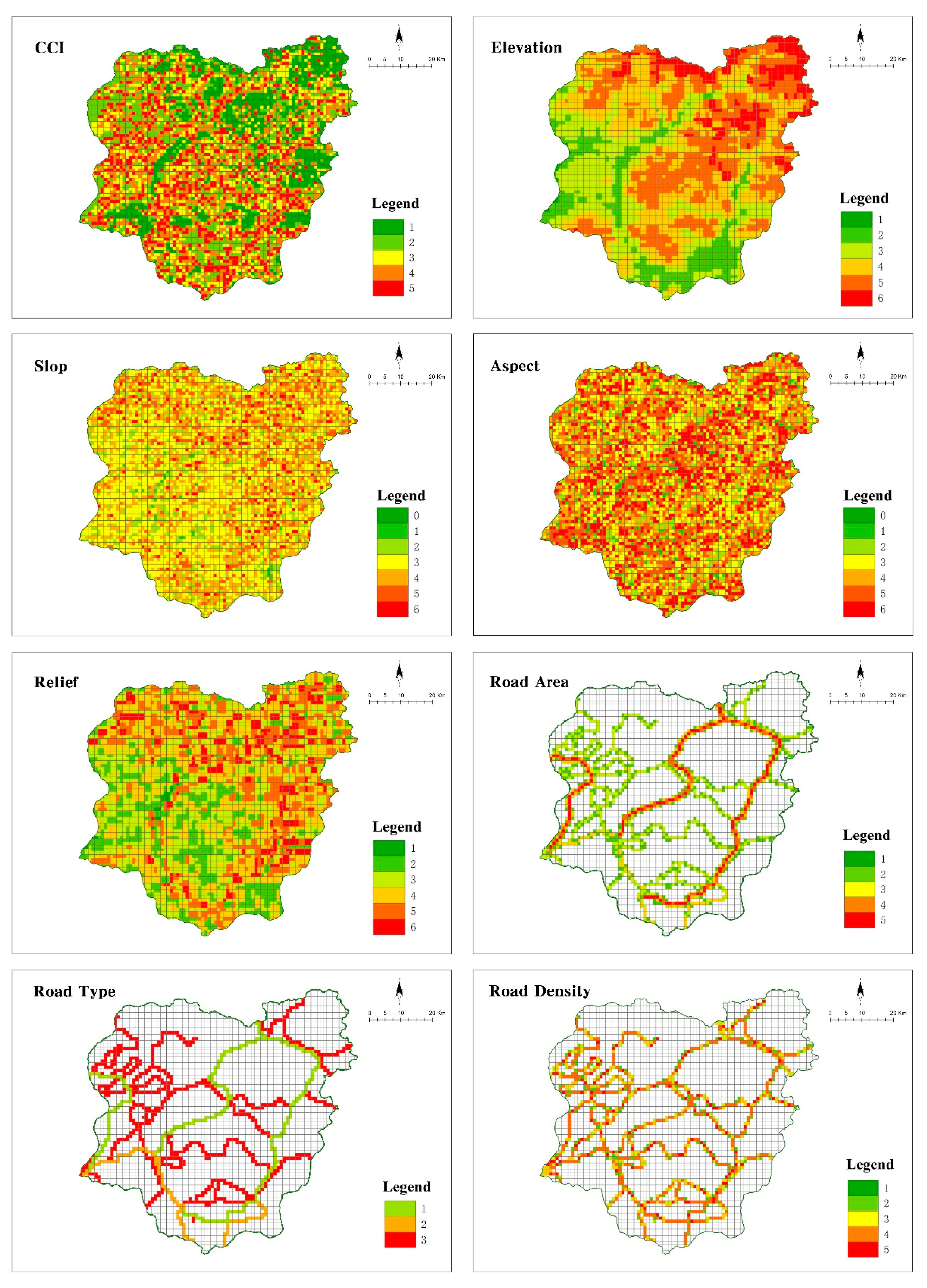
Various ecological factors might influence the landscape of roads, notably the type and width of roads, which are related to the number of wild animals passing the road and is associated mortality [
58,
59].
Road area is the product of the road width and length. It can reflect not only the road of the landscape type, but also the number of wild animals passing through the road. The terrain is also an important factor affecting ecosystems and the distribution of landscape patterns, vegetation, and soil on a large scale, and determines the formation and evolution of the landscape pattern on spatial scales [
15,
60].
In the present study, we found that the CCI and road density, relief, slope, and aspect on the ecological corridor changes were synergistic, and the effects of CCI and road area, road type, or elevation were mutually strengthening. Because the cutting effect of ‘road-effect zones’ directly leads to the fragmentation of habitats, it changes the landscape pattern of the area and affects the functioning of ecosystems [
61]. It is also an important factor affecting the number and direction of ecological corridors, all of which were confirmed in the present study. Elevation itself has a correlation with climate and topographic factors, and directly affects the route selection and road construction. We found that the interaction between elevation and other factors had a significantly higher explanatory power on the corridor changes than each of the factors alone, validating the interaction between the elevation and the above-described factors.
The interaction of the road area and road density or road type on the changes in the corridor exhibited a mutual strengthening effect, manifested by the direct effects of the increased road density and road area on the regional landscape pattern, as well as on the type, proportion, size, structure, and soil of the landscape patches near the roads. It further influences and changes the structure and processes of the regional ecosystems [
59].
4.5. Issue of Boundary of the Study Area
The study area of Kanas is located in the region of Altai, which has areas of 780,000 km
2, including China, Russia, Kazakhstan, and Mongolia [
62]. The study of Liu, 2016, taking 22 nature reserves as the source units, established 94 ecological corridors among those reserves in the Altai Region, of which there were 24 cross-national border corridors. There were three main places that had a higher concentration extent of ecologic corridors. One of them was the center of the Mongolian border, the Forest Grassland Corridor Belt, which contained Kanas, China; Liang Heyuan area, China; and Ukok area in the Russian Jinshan Altai World Heritage. Through the field investigation of those three areas, we found that the Ukok area in Russia and te Liang Heyuan region in China have good ecological environment protection, and there were no anthropogenic activities, such as large-scale road construction, and the degree of interference by humans was negligible. Whereas, in Kanas, an important tourist attraction in Xinjiang, the road expansion affected the environment in the region to some extent, and therefore, we chose the region as the research area, in order to provide evidence for the need for ecological protection in the following areas, by studying the relationship between the road construction and ecological corridor.
However, as the present study area was only in Kanas, we ignored the influence of the entire regional road network and ecological corridor network of the Altai Mountain. In the future, we will evaluate the scale effect of the roads and ecological corridors on the cross-boundary scale.
4.6. Strengths and Limitations of This Study and Prospects
Currently, the studies on road ecology include those on the relationship of roads with landscape coordination, landscape pattern, landscape connectivity, land use change, ecological security, and road network characteristics. In the present study, we focused on the relation between roads and the ecological corridors of wildlife movement, and modeled the ecological corridors by determining the ‘road-effect zones’ CCI, and by using the MCR model to quantitatively analyze the relation between the corridor changes and other factors, such as CCI, road geometry, and terrain. The study fully examined the effect of roads on the ecological corridors. To analyze the relationship between the corridor changes and other factors, we used the geographical detector model to quantitatively analyze the interaction of the CCI, as well as the road geometry and terrain, which was the objective and rational.
In the study of the ecological corridor for wildlife movement, experts usually use AHP to calculate the weight coefficient, therefore, a consensus on the setting of the resistance value of the landscape has not been achieved. In this context, we took the landscape resistance factors into account and chose elevation, slope, soil type, vegetation coverage, and land use type, which, to some extent, meet the requirements of constructing ecological corridors and provide good implications while being in line with local conditions. However, the weights of the landscape resistance factors used in the minimum resistance model were determined through the comprehensive score given by experts, which is rather subjective. To overcome this shortcoming, we will use the expert scoring form as an appendix (see
Appendix A) to determine the resistance value. Moreover, we did not analyze the disruption to movement by the specific species, which might affect the specificity of the results. In the future, we will investigate the migration process of the flagship species in the heritage site and the corridors of the important species to guide the layout of new road construction. Furthermore, the interests of various stakeholders in the site will be taken into account, which will provide a reference for the ecological compensation measures required for road construction, and will have practical application value in the protection of biodiversity, the ecological design of roads, and the planning of landscapes in the heritage site.


