Walking Access to Public Transportation Stops for City Residents. A Comparison of Methods


Abstract
:1. Introduction
2. Study Area, Data, Research Methods, and Procedure
2.1. The Case Study Area
2.2. Data
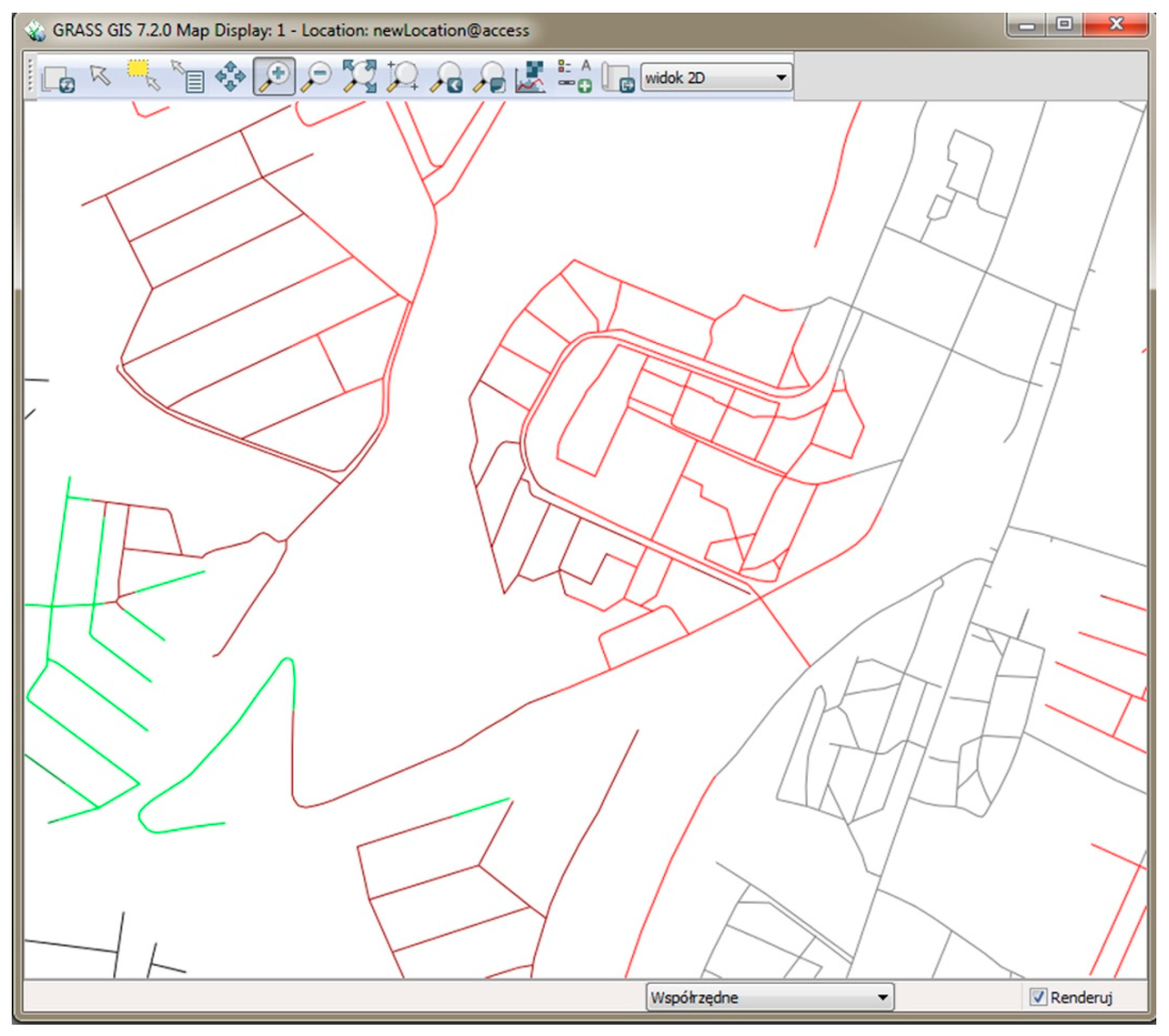
2.3. Methods
2.4. Research Procedure
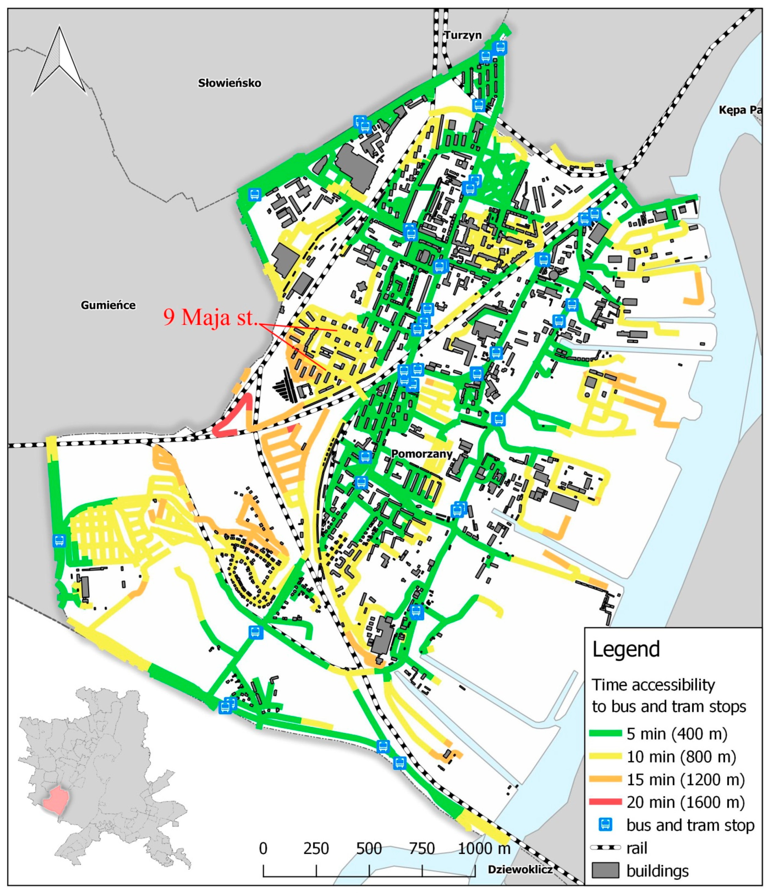
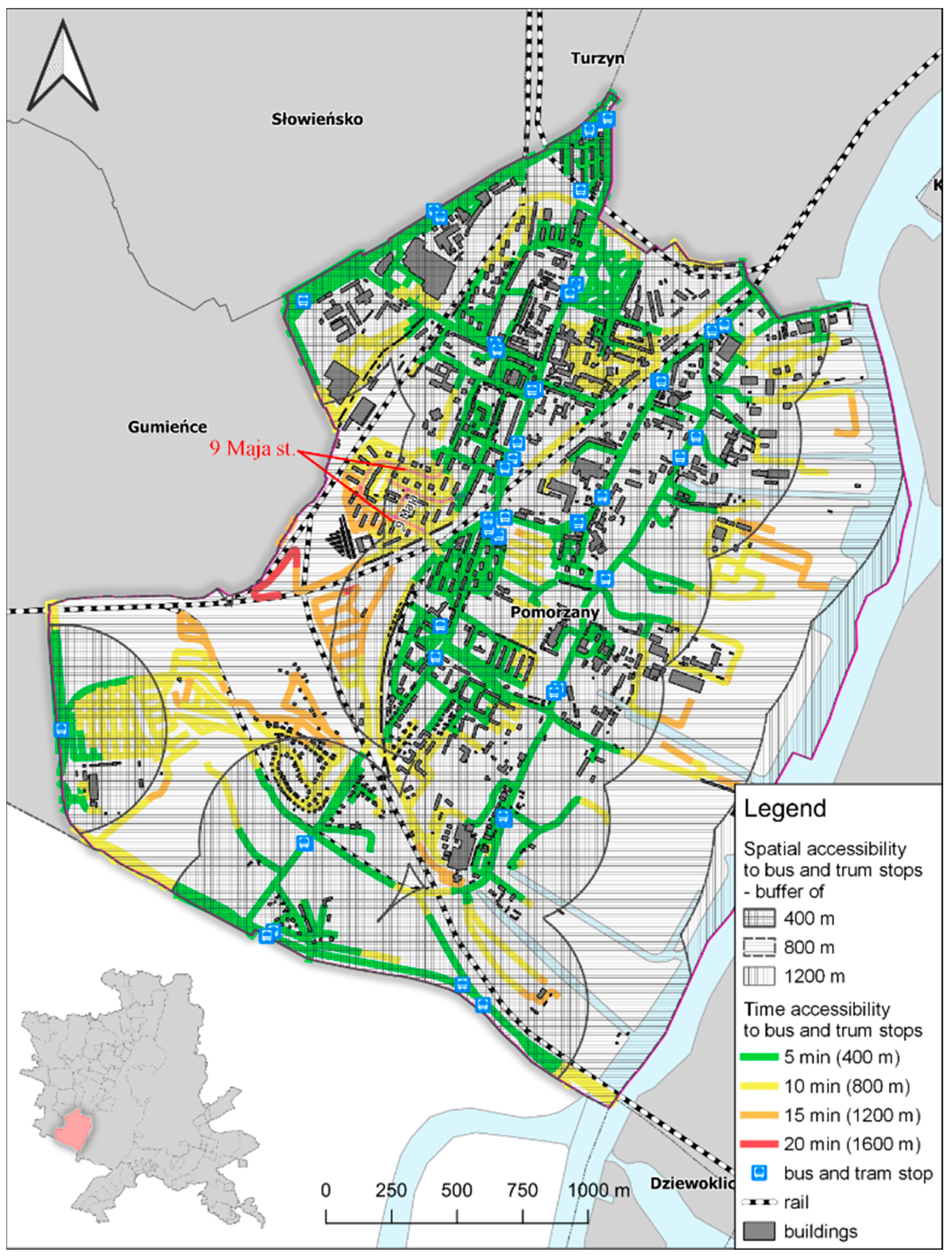
3. Results
4. Discussion
Author Contributions
Funding
Conflicts of Interest
References
- Kittelson & Associates, Inc. Transit Capacity and Quality of Service Manual, 2nd ed.; TCRP Project 100; TRB, National Research Council: Washington, DC, USA, 2003. [Google Scholar]
- Newman, P.; Kenworthy, J. Sustainability and Cities: Overcoming Automobile Dependence; Island Press: Washington, DC, USA, 1999. [Google Scholar]
- Murray, A.T.; Davis, R.; Stimson, R.J.; Ferreira, L. Public transportation access. Transp. Res. D Transp. Environ. 1998, 3, 319–328. [Google Scholar] [CrossRef]
- Olawole, M.O. Accessibility to Lagos Bus Rapid Transit (BRT LITE) Bus Stops: An Empirical Study; CODATU XV: Addis Ababa, Ethiopia, 2012. [Google Scholar]
- Murray, A.T. Strategic analysis of public transport coverage. Socio-Econ. Plan. Sci. 2001, 35, 175–188. [Google Scholar] [CrossRef]
- Wachs, M.; Kumagai, T.G. Physical accessibility as a social indicator. Socio-Econ. Plan. Sci. 1973, 7, 437–456. [Google Scholar] [CrossRef]
- Bok, J.; Kwon, Y. Comparable Measures of Accessibility to Public Transport Using the General Transit Feed Specification. Sustainability 2016, 8, 224. [Google Scholar] [CrossRef]
- Litman, T. The Economic Value of Walkability; Victoria Transport Policy Institute: Victoria, BC, Canada, 2007. [Google Scholar]
- Gomide, A.; Leite, S.; Revelo, J. Transport and Urban Poverty: A Synthetic Index of Adequate Service; World Bank: Washington, DC, USA, 2005. [Google Scholar]
- Bhat, C.; Bricka, S.; Mondia, J.L.; Kapur, A.; Guo, J.; Sen, S. Metropolitan Area Transit Accessibility Analysis Tool; Centre for Transportation Research University of Texas: Austin, TX, USA, 2006; pp. 33–44. [Google Scholar]
- Vuchic, V.R. Transportation for Livable Cities; CUPR: New Brunswick, NB, Canada, 1999; pp. 198–201. [Google Scholar]
- Littman, T. Transit Oriented Development: Using Public Transit to Create More Accessible and Livable Neighborhoods. In TDM Encyclopedia; Victoria Transport Policy Institute: Victoria, BC, Canada, 2017. [Google Scholar]
- Sinha, K.C.; Labi, S. Transportation Decision Making; Wiley and Sons: Hoboken, NJ, USA, 2007; pp. 23–27. [Google Scholar]
- Grava, S. Urban Transportation Systems: Choices for Communities; McGraw-Hill: New York, NY, USA, 2003; pp. 1–12. [Google Scholar]
- Corazza, M.V.; Favaretto, N. A Methodology to Evaluate Accessibility to Bus Stops as a Contribution to Improve Sustainability in Urban Mobility. Sustainability 2019, 11, 803. [Google Scholar] [CrossRef] [Green Version]
- Litman, T. Evaluating Accessibility for Transport Planning Measuring People’s Ability to Reach Desired Goods and Activities; Victoria Transport Policy Institute: Victoria, BC, Canada, 2018. [Google Scholar]
- Beimborn, E.A.; Greenwald, M.J.; Jin, X. Impacts of transit accessibility and connectivity on transit choice and captivity. Transp. Res. Rec. 2003, 1835, 1–9. [Google Scholar] [CrossRef]
- Ker, I.; Ginn, S. Myths and Realities in Walkable Catchments: The case of Walking and Transit. In Proceedings of the 21st ARRB and 11th REAAA Conference 90CD-ROM), Cairns, Australia, 18–23 May 2003. [Google Scholar]
- Hine, J.; Mitchell, F. The Role of Transport in Social Exclusion in Urban Scotland; Scottish Executive, Central Research Unit: Edinburgh, UK, 2001. [Google Scholar]
- Hine, J.; Mitchell, F. Better for everyone? Travel experiences and transport exclusion. Urban Stud. 2001, 38, 319–322. [Google Scholar] [CrossRef]
- Hine, J.; Mitchell, F. Transport Disadvantage and Social Exclusion; Ashgate Publishing: Aldershot, UK, 2003. [Google Scholar]
- O’Neill, W.A.; Ramsey, R.D.; Chou, J. Analysis of transit service areas using geographic information systems. Transp. Res. Rec. 1992, 1364, 131–138. [Google Scholar]
- Groß, D.R.P.; Hamacher, H.W.; Horn, S.; Schöbel, A. Stop location design in public transportation networks: Covering and accessibility objectives. Top 2009, 17, 335. [Google Scholar]
- Hsiao, S.; Lu, J.; Sterling, J.; Weatherford, M. Use of geographic information system for analysis of transit pedestrian access. Transp. Res. Rec. 1997, 1604, 50–59. [Google Scholar] [CrossRef]
- Aultman-Hall, L.; Roorda, M.; Baetz, B.W. Using GIS for evaluation of neighborhood pedestrian accessibility. J. Urban Plan. Dev. 1997, 123, 10–17. [Google Scholar] [CrossRef]
- Phillips, C.G.; Edwards, H.R. Socioeconomic, community-based approach for developing integrated mass transit systems application to city of Baltimore, Maryland. Transp. Res. Rec. 2002, 1797, 71–79. [Google Scholar] [CrossRef]
- Foda, M.A.; Osman, A.O. Using GIS for measuring transit stop accessibility considering actual pedestrian road network. J. Public Transp. 2010, 13, 2. [Google Scholar] [CrossRef]
- Ammons, D.N. Municipal Benchmarks: Assessing Local Performance and Establishing Community Standards, 2nd ed.; Sage: Thousand Oaks, CA, USA, 2001. [Google Scholar]
- Zhao, F.; Chow, L.F.; Li, M.T.; Ubaka, I.; Gan, A. Forecasting transit walk accessibility—Regression model alternative to buffer method. Transp. Res. Rec. 2003, 1835, 34–41. [Google Scholar] [CrossRef]
- Loutzenheiser, D.R. Pedestrian access to transit: Model of walk trips and their design and urban form determinants around bar area rapid transit stations. Transp. Res. Rec. 1997, 1604, 40–49. [Google Scholar] [CrossRef]
- Ayvalik, C.K.; Khisty, C.J. Heuristic analysis of impacts of commuter rail station consolidation on pedestrian access. Transp. Res. Rec. 2002, 1793, 47–54. [Google Scholar] [CrossRef]
- Sypion-Dutkowska, N.; Leitner, M. Land Use Influencing the Spatial Distribution of Urban Crime: A Case Study of Szczecin, Poland. ISPRS Int. J. Geoinf. 2017, 6, 74. [Google Scholar] [CrossRef]
- Historia Komunikacji Miejskiej w Szczecinie. Available online: http://www.swiatowy.org/ (accessed on 14 January 2019).
- Kaszczyszyn, P. Evolution of urban structure and the influence on walkability. In Poszerzamy horyzonty, Tom IX; Bogusz, M., Wojcieszak, M., Rachwał, P., Eds.; Mateusz Weiland Network Solutions: Słupsk, Poland, 2018; pp. 136–150. [Google Scholar]
- Carr, L.J.; Dunsiger, S.I.; Marcus, B.H. Walk Score as a Global Estimate of Neighborhood Walkability. Am. J. Prev. Med. 2010, 39, 460–463. [Google Scholar] [CrossRef] [PubMed]
- 10 Techniques for Making Cities More Walkable. Available online: https://www.citylab.com/solutions/2012/12/10-techniques-making-cities-more-walkable/4047/ (accessed on 14 January 2019).
- Grass Tutorial. Synopsis 1. Available online: https://grass.osgeo.org/grass74/manuals/v.net.iso.html (accessed on 14 January 2019).
- Grass Tutorial. Synopsis 2. Available online: https://grass.osgeo.org/grass77/manuals/v.net.html (accessed on 14 January 2019).


| No. | Street | Population |
|---|---|---|
| 1 | Zawadzkiego | 4181 |
| 2 | Szafera | 3917 |
| 3 | Wyzwolenia | 3620 |
| 4 | Jasna | 3480 |
| 5 | Santocka | 3271 |
| 6 | 9 Maja * | 2895 |
| 7 | Rydla | 2875 |
| 8 | Jagiellońska | 2835 |
| 9 | 26 Kwietnia | 2758 |
| 10 | Kaliny | 2696 |
| Distance to Public Transport Stop [m] | Time [min] | Color Code | Accessibility Level |
|---|---|---|---|
| 0–400 | 0–5 | High | |
| 400–800 | 5–10 | Moderate | |
| 800–1200 | 10–15 | Poor | |
| 1200–1600 | 15–20 | Inaccessible |
| Distance to Public Transport Stop (m) | Time (min) | Color Code | Accessibility Level | Length (km) | Percentage (%) |
|---|---|---|---|---|---|
| 0–400 | 0–5 | High | 1094.4 | 46.4 | |
| 400–800 | 5–10 | Moderate | 639.8 | 27.1 | |
| 800–1200 | 10–15 | Poor | 306.9 | 13 | |
| 1200–1600* | 15–20 * | Inaccessible | 318.2 | 13.5 |
| Method | Distance to Public Transport Stop (m) | Time (min) | Color/Pattern Code | Accessibility Level | Length (km)/Area (km2) | Percentage (%) |
|---|---|---|---|---|---|---|
| Band (length) | 0–400 | 0–5 | High | 47.99 | 53.8 | |
| 400–800 | 5–10 | Moderate | 33.8 | 37.9 | ||
| 800–1200 | 10–15 | Poor | 6.95 | 7.8 | ||
| 1200–1600 | 15–20 | Inaccessible | 0.45 | 0.5 | ||
| Buffer (area) | 0–400 | 0–5 |  | High | 4.72 | 66.5 |
| 400–800 | 5–10 |  | Moderate | 2.09 | 29.4 | |
| 800–1200 | 10–15 |  | Poor | 0.26 | 3.7 | |
| 1200–1600 | 15–20 | none | Inaccessible | 0 | 0 |
© 2019 by the authors. Licensee MDPI, Basel, Switzerland. This article is an open access article distributed under the terms and conditions of the Creative Commons Attribution (CC BY) license (http://creativecommons.org/licenses/by/4.0/).
Share and Cite
Kaszczyszyn, P.; Sypion-Dutkowska, N. Walking Access to Public Transportation Stops for City Residents. A Comparison of Methods. Sustainability 2019, 11, 3758. https://doi.org/10.3390/su11143758
Kaszczyszyn P, Sypion-Dutkowska N. Walking Access to Public Transportation Stops for City Residents. A Comparison of Methods. Sustainability. 2019; 11(14):3758. https://doi.org/10.3390/su11143758
Chicago/Turabian StyleKaszczyszyn, Piotr, and Natalia Sypion-Dutkowska. 2019. "Walking Access to Public Transportation Stops for City Residents. A Comparison of Methods" Sustainability 11, no. 14: 3758. https://doi.org/10.3390/su11143758
APA StyleKaszczyszyn, P., & Sypion-Dutkowska, N. (2019). Walking Access to Public Transportation Stops for City Residents. A Comparison of Methods. Sustainability, 11(14), 3758. https://doi.org/10.3390/su11143758