Spatio–Temporal Variations in Impervious Surface Patterns during Urban Expansion in a Coastal City: Xiamen, China

Abstract
:1. Introduction
2. Methodology
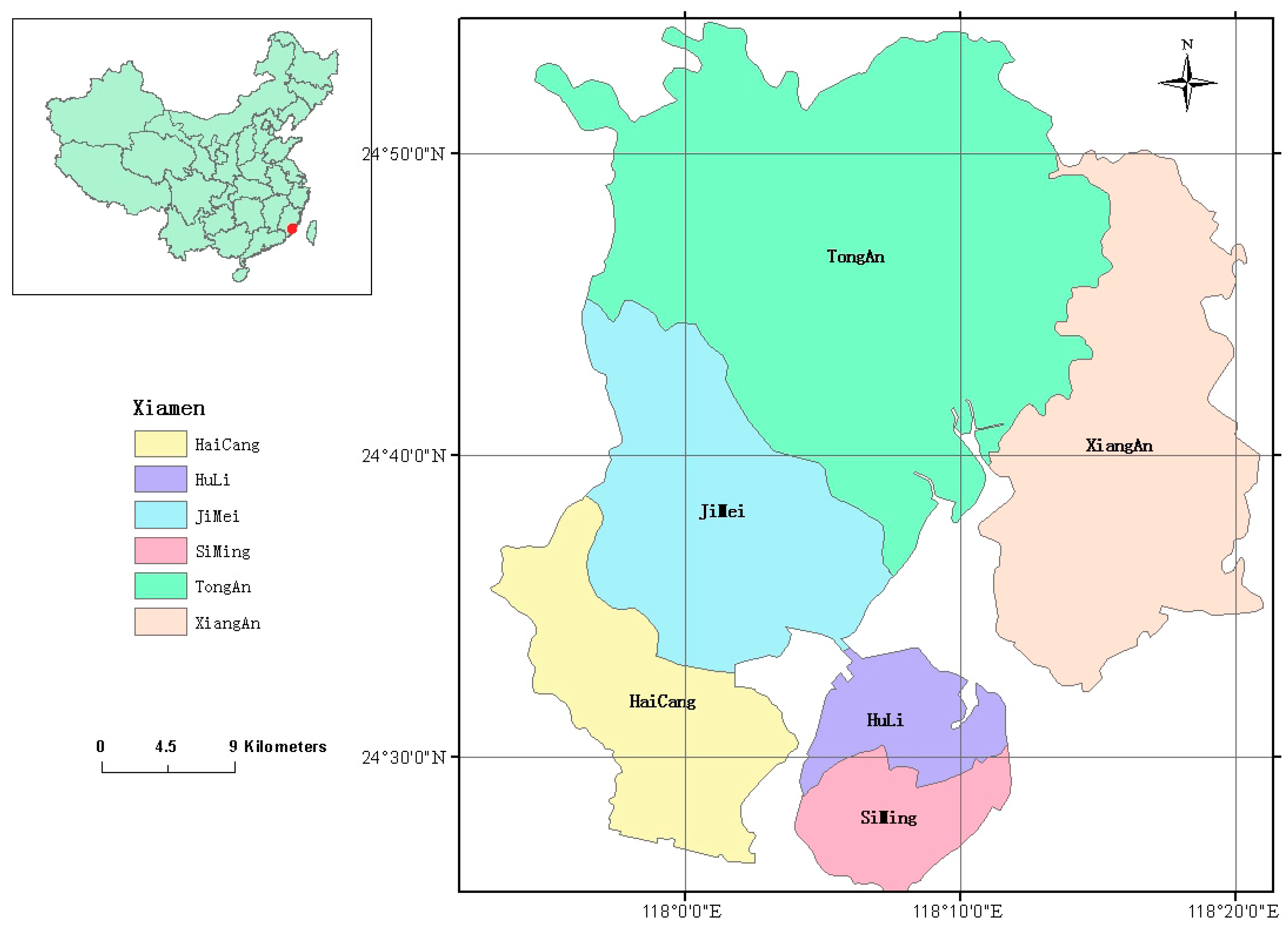
2.1. Study Area and Data Preprocessing
2.2. Estimation of IS
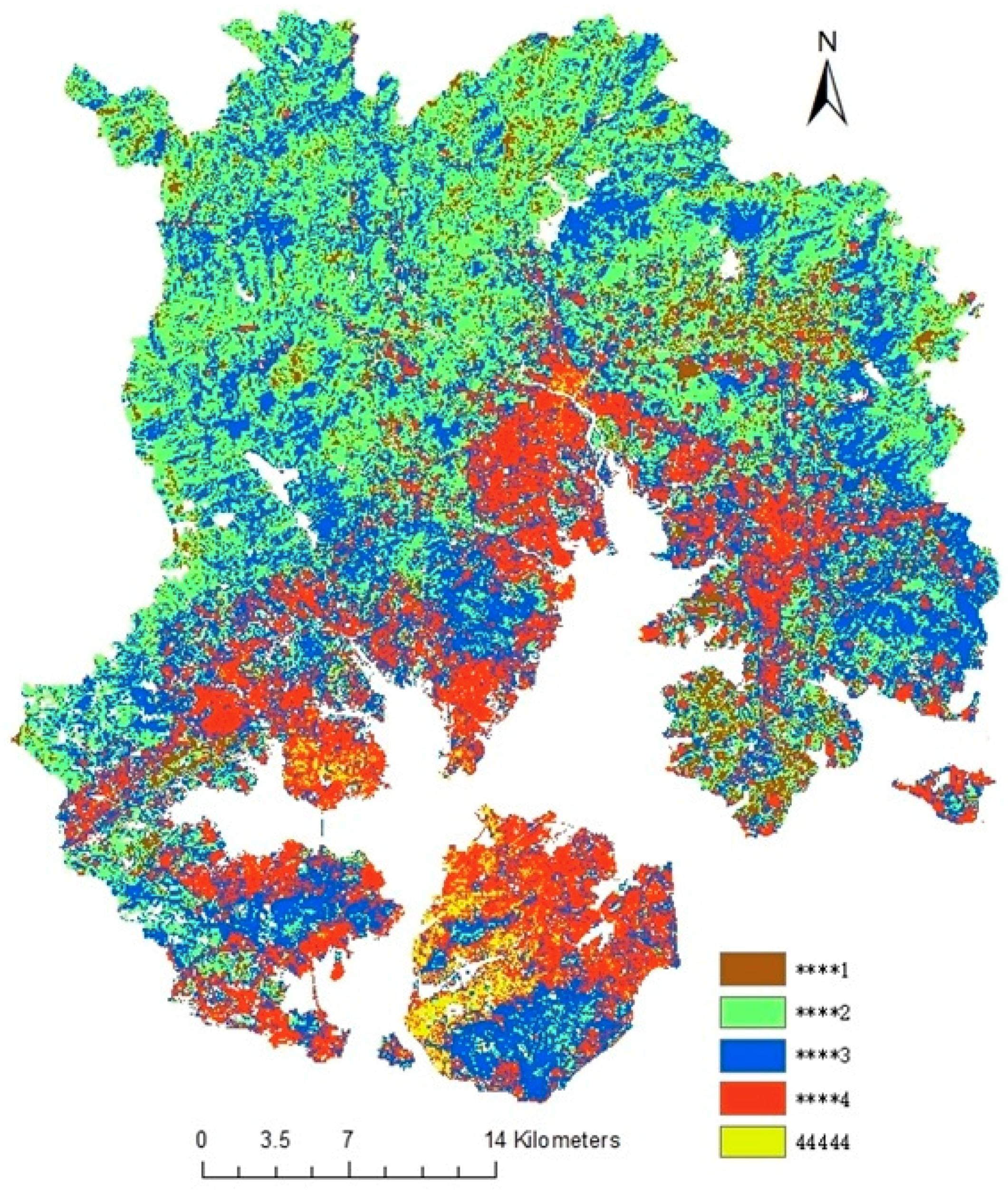
2.3. IS Change Trajectory
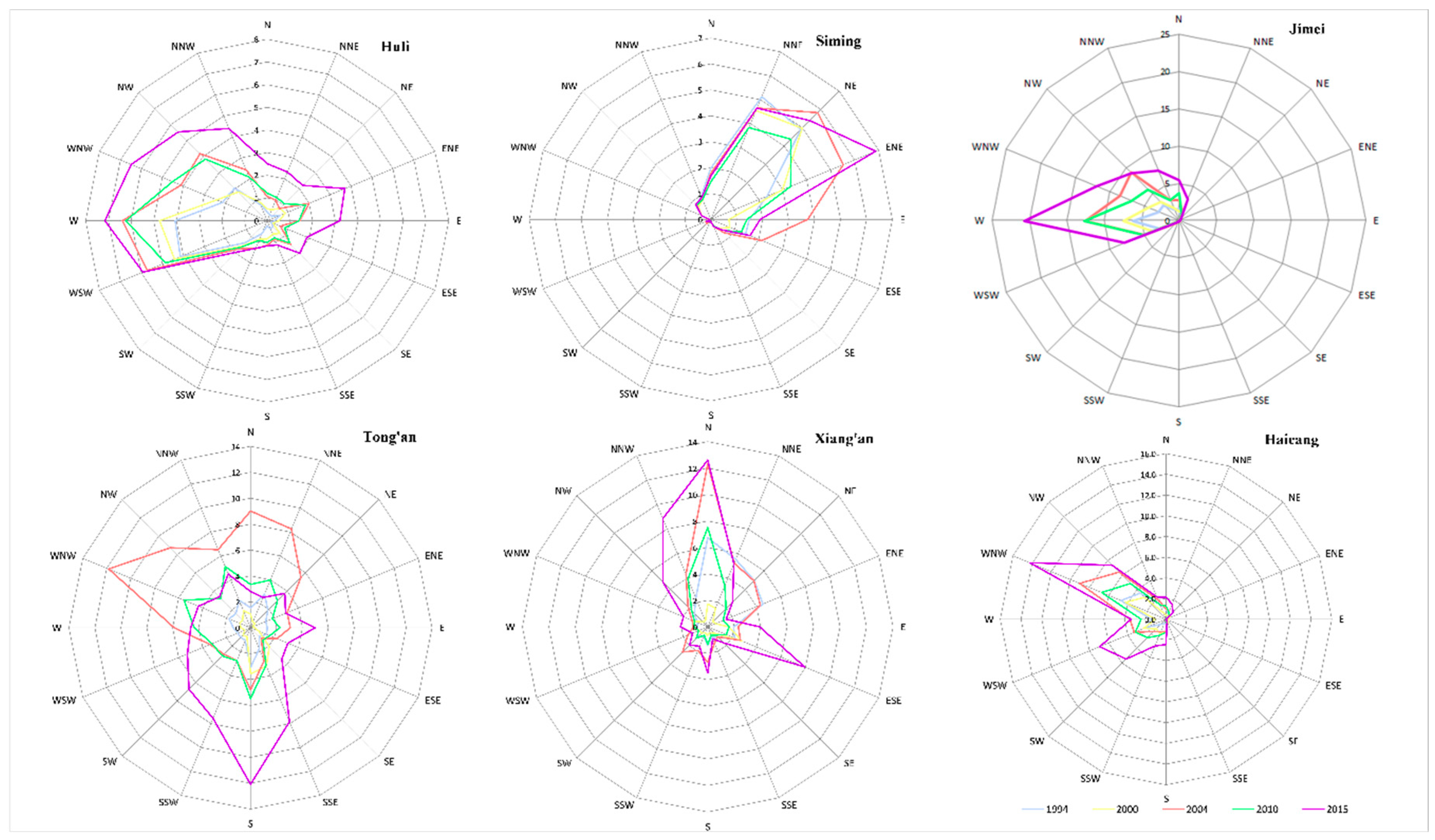
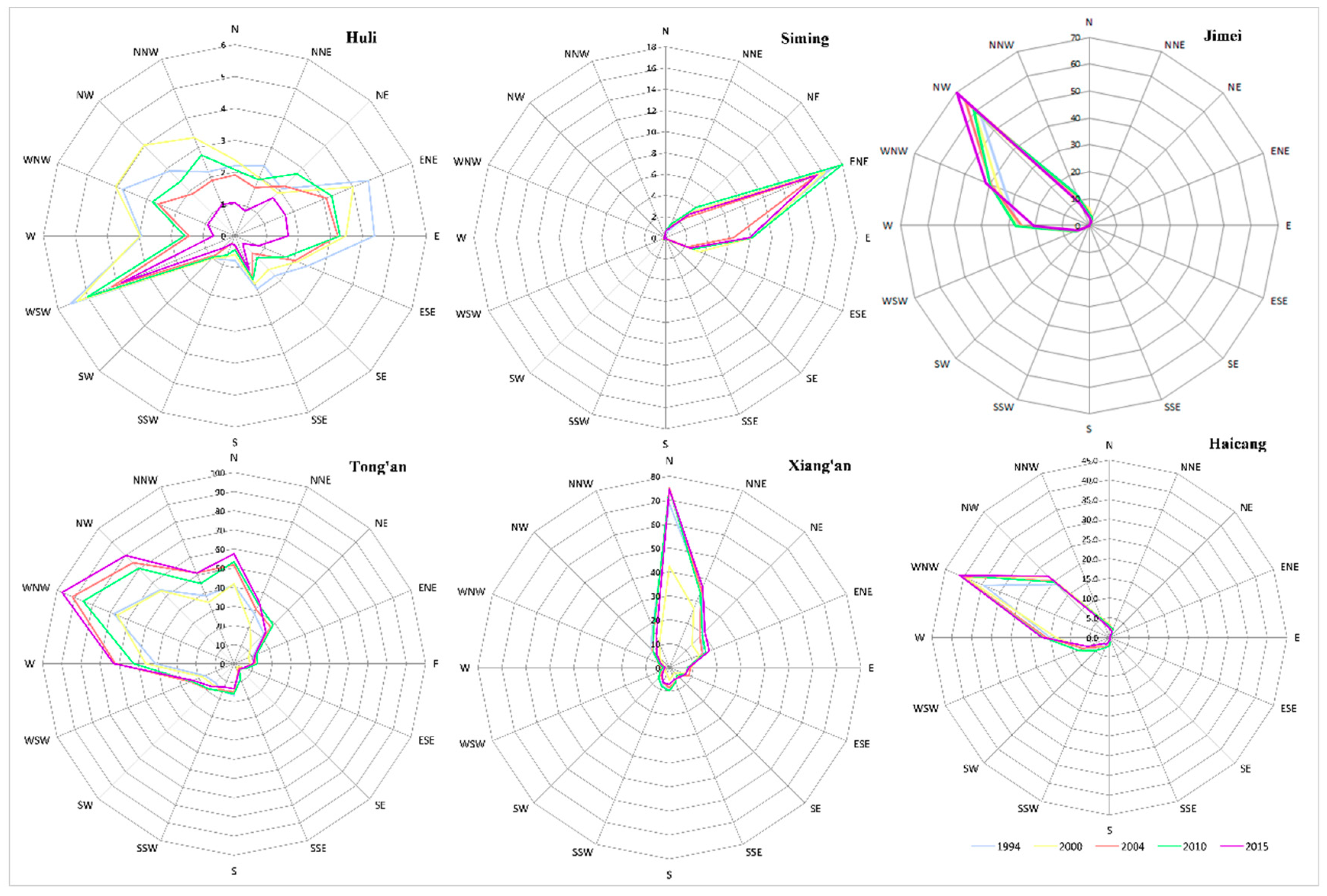
2.4. Radar Graphs
3. Results
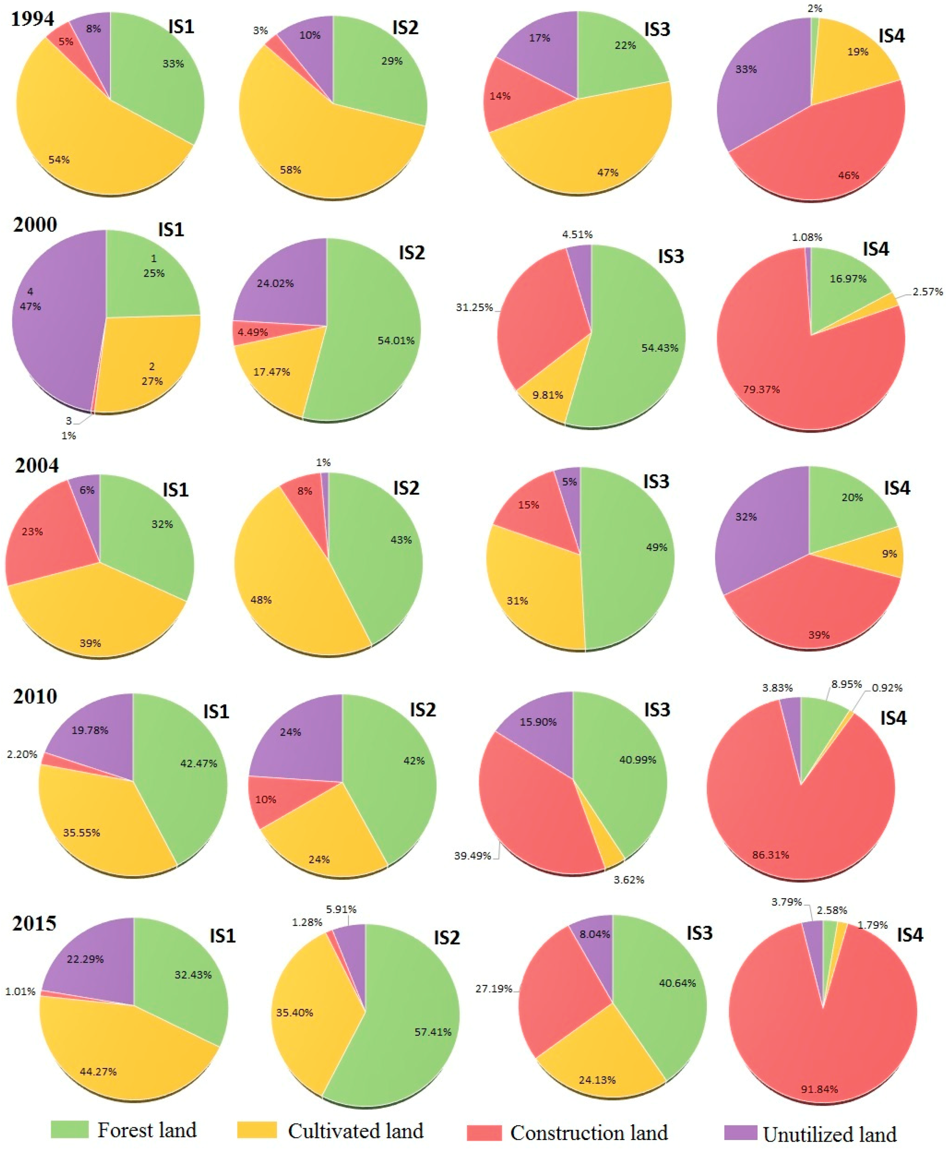
3.1. Variation of Impervious Surface Association with Land Use During the Study Period
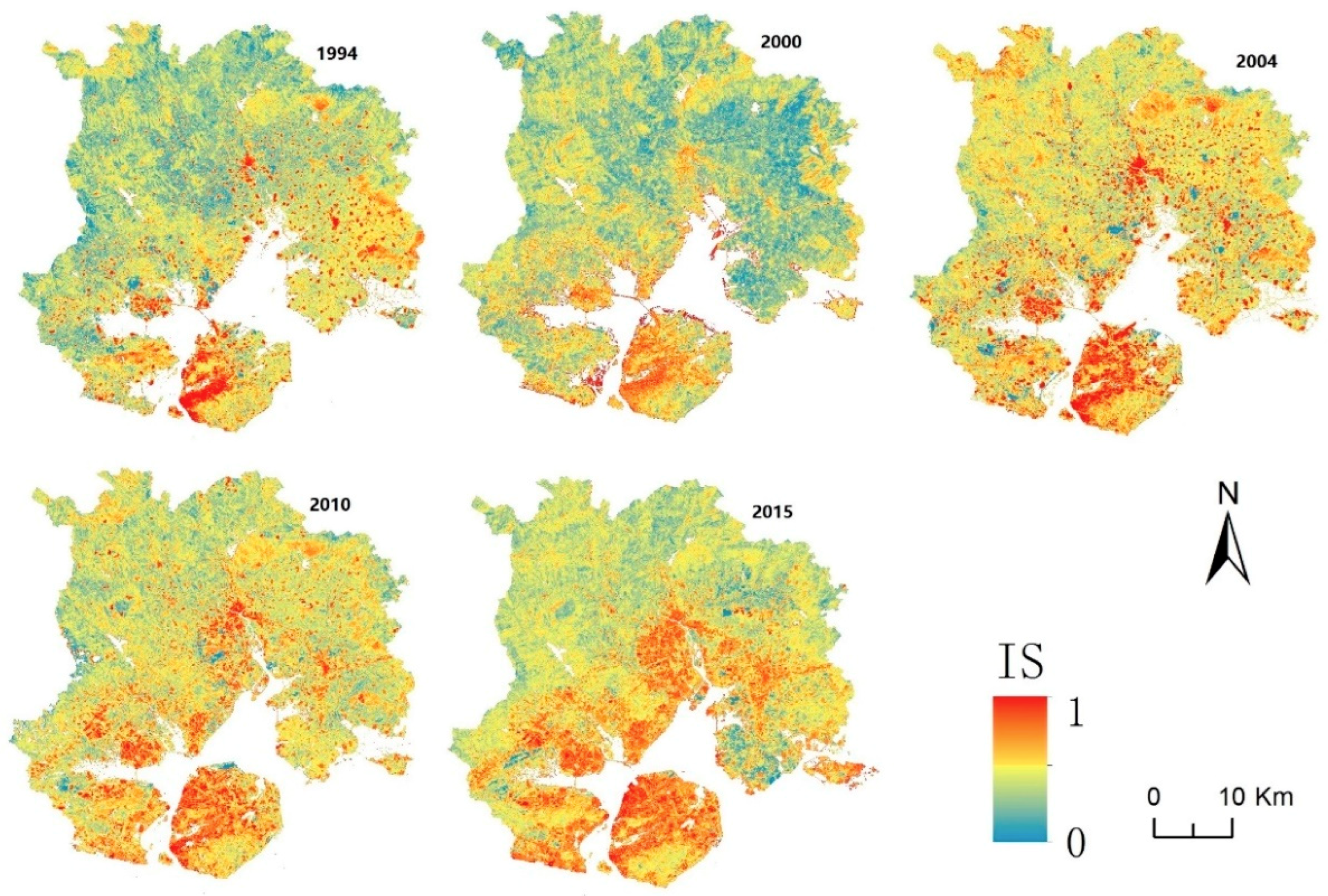
3.2. Progression of IS Spatio–Temporal Variation
3.3. Spatio–Temporal Orientation of IS Expansion Associated with Urban Expansion
4. Discussion and Conclusions
4.1. Discussion
4.2. Conclusions
Author Contributions
Funding
Acknowledgments
Conflicts of Interest
References
- World Bank. World Bank Database. Available online: http://data.worldbank.org (accessed on 13 May 2015).
- Seto, K.C.; Kaufmann, R.K. Modeling the drivers of urban land use change in the Pearl River Delta, China: Integrating remote sensing with socioeconomic data. Land Econ. 2003, 79, 106–121. [Google Scholar] [CrossRef]
- Jaeger, J.A.; Bertiller, R.; Schwick, C.; Cavens, D.; Kienast, F. Urban permeation of landscapes and sprawl per capita: New measures of urban sprawl. Ecol. Indic. 2010, 10, 427–441. [Google Scholar] [CrossRef]
- Gomes, E.; Banos, A.; Abrantes, P.; Rocha, J. Assessing the Effect of Spatial Proximity on Urban Growth. Sustainability 2018, 10, 1308. [Google Scholar] [CrossRef]
- Hamidi, S.; Ewing, R.; Preuss, I.; Dodds, A. Measuring sprawl and its impacts: An update. J. Plan. Educ. Res. 2015, 35, 35–50. [Google Scholar] [CrossRef]
- Wei, Y.D.; Li, H.; Yue, W. Urban land expansion and regional inequality in transitional China. Landsc. Urban Plan. 2017, 163, 17–31. [Google Scholar] [CrossRef]
- Xian, G.; Crane, M.; Su, J. An analysis of urban development and its environmental impact on the Tampa Bay watershed. J. Environ. Manag. 2007, 85, 965–976. [Google Scholar] [CrossRef]
- Fan, F.; Fan, W. Understanding Spatial-temporal Urban Expansion Pattern (1990–2009) Using Impervious Surface Data and Landscape Indexes: A Case Study in Guangzhou (China). J. Appl. Remote Sens. 2014, 8, 4480–4494. [Google Scholar] [CrossRef]
- Shahtahmassebi, A.R.; Song, J.; Zheng, Q.; Blackburn, G.A.; Wang, K.; Huang, L.Y.; Pan, Y.; Moore, N.; Shahtahmassebi, G.; Haghighi, R.S.; et al. Remote sensing of impervious surface growth: A framework for quantifying urban expansion and re-densification mechanisms. Int. J. Appl. Earth Obs. Geoinf. 2016, 46, 94–112. [Google Scholar] [CrossRef] [Green Version]
- Chen, X.L.; Zhao, H.M.; Li, P.X.; Yin, Z.Y. Remote sensing image-based analysis of the relationship between urban heat island and land use/cover changes. Remote Sens. Environ. 2006, 104, 133–146. [Google Scholar] [CrossRef]
- Ma, Q.; He, C.; Wu, J. Behind the rapid expansion of urban impervious surfaces in China: Major influencing factors revealed by a hierarchical multiscale analysis. Land Use Policy 2016, 59, 434–445. [Google Scholar] [CrossRef]
- Nie, Q.; Man, W.; Li, Z.; Huang, Y. Spatio-Temporal Impact of Urban Impervious Surface on Land Surface Temperature in Shanghai, China. Can. J. Remote Sens. 2016, 42, 680–689. [Google Scholar] [CrossRef]
- Nie, Q.; Xu, J.; Liu, Z. Fractal and multifractal characteristic of spatial pattern of urban impervious surfaces. Earth Sci. Inform. 2015, 8, 381–392. [Google Scholar] [CrossRef]
- Weng, Q. Remote sensing of impervious surfaces in the urban areas: Requirements, methods, and trends. Remote Sens. Environ. 2012, 117, 34–49. [Google Scholar] [CrossRef]
- Xian, G.; Crane, M. An analysis of urban thermal characteristics and associated land cover in Tampa Bay and Las Vegas using Landsat satellite data. Remote Sens. Environ. 2006, 104, 147–156. [Google Scholar] [CrossRef]
- Rashed, T. Remote sensing of within-class change in urban neighborhood structures. Comput. Environ. Urban Syst. 2008, 32, 343–354. [Google Scholar] [CrossRef]
- Deng, Y.; Fan, F.; Chen, R. Extraction and Analysis of Impervious Surfaces Based on a Spectral Un-Mixing Method Using Pearl River Delta of China Landsat TM/ETM + Imagery from 1998 to 2008. Sensors 2012, 12, 1846. [Google Scholar] [CrossRef]
- Zhou, B.; He, H.S.; Nigh, T.A.; Schulz, J.H. Mapping and analyzing change of impervious surface for two decades using multi-temporal Landsat imagery in Missouri. Int. J. Appl. Earth Obs. Geoinf. 2012, 18, 195–206. [Google Scholar] [CrossRef]
- Zhang, L.; Weng, Q.; Shao, Z. An evaluation of monthly impervious surface dynamics by fusing Landsat and MODIS time series in the Pearl River Delta, China, from 2000 to 2015. Remote Sens. Environ. 2017, 201, 99–114. [Google Scholar] [CrossRef]
- Xu, J.; Zhao, Y.; Zhong, K.; Zhang, F.; Liu, X.; Sun, C. Measuring spatio-temporal dynamics of impervious surface in Guangzhou, China, from 1988 to 2015, using time-series Landsat imagery. Sci. Total. Environ. 2018, 627, 264–281. [Google Scholar] [CrossRef] [PubMed]
- Li, W.; Wu, C.; Choi, W. Predicting future urban impervious surface distribution using cellular automata and regression analysis. Earth Sci. Inform. 2018, 11, 19–29. [Google Scholar] [CrossRef]
- Zhang, L.; Zhang, M.; Yao, Y. Mapping seasonal impervious surface dynamics in Wuhan urban agglomeration, China from 2000 to 2016. Int. J. Appl. Earth Obs. Geoinf. 2016, 70, 51–61. [Google Scholar] [CrossRef]
- Zhang, H.; Lin, H.; Wang, Y. A new scheme for urban impervious surface classification from SAR images. ISPRS J. Photogramm. Remote Sens. 2018, 139, 103–118. [Google Scholar] [CrossRef]
- Wu, J.; Thompson, J. Quantifying impervious surface changes using time series planimetric data from 1940 to 2011 in four central low a cities, USA. Landsc. Urban Plan. 2013, 120, 34–47. [Google Scholar] [CrossRef]
- Man, W.; Nie, Q.; Li, Z.; Li, H.; Wu, X. Using fractals and multifractals to characterize the spatiotemporal pattern of impervious surfaces in a coastal city: Xiamen, China. Phys. A Stat. Mech. Its Appl. 2019, 520, 44–53. [Google Scholar] [CrossRef]
- Wilson, C.R.; Brown, D.G. Change in visible impervious surface area in southeastern Michigan before and after the Great Recession: Spatial differentiation in remotely sensed land-cover dynamics. Popul. Environ. 2015, 36, 331–355. [Google Scholar] [CrossRef]
- Xian, G.; Homer, C. Updating the 2001 National Land Cover Database impervious surface products to 2006 using Landsat imagery change detection methods. Remote Sens. Environ. 2010, 114, 1676–1686. [Google Scholar] [CrossRef]
- China Geospatial Data Cloud. Available online: http://www.gscloud.cn/ (accessed on 19 April 2019).
- Small, C. Estimation of urban vegetation abundance by spectral mixture analysis. Int. J. Remote Sens. 2001, 22, 1305–1334. [Google Scholar] [CrossRef] [Green Version]
- Salerno, F.; Gaetano, V.; Gianni, T.; Franco, S. Urbanization and climate change impacts on surface water quality: Enhancing the resilience by reducing impervious surfaces. Water Res. 2018, 144, 491–502. [Google Scholar] [CrossRef]
- Xu, H.; Shi, T.; Wang, M.; Fang, C.; Lin, Z. Predicting effect of forthcoming population growth–induced impervious surface increase on regional thermal environment: Xiong’an New Area, North China. Build. Environ. 2018, 136, 98–106. [Google Scholar] [CrossRef]
- Yan, Z.; Teng, M.; He, W.; Liu, A.; Li, Y.; Wang, P. Impervious surface area is a key predictor for urban plant diversity in a city undergone rapid urbanization. Sci. Total. Environ. 2019, 650, 335–342. [Google Scholar] [CrossRef]
- Song, Y.; Li, F.; Wang, X.; Xu, C.; Zhang, J.; Liu, X.; Zhang, H. The effects of urban impervious surfaces on eco-physiological characteristics of Ginkgo biloba: A case study from Beijing, China. For. Green. 2015, 14, 1102–1109. [Google Scholar] [CrossRef] [Green Version]
- Wu, X.; Hu, D.; Ma, S.; Zhang, X.; Guo, Z.; Gaston, K.J. Elevated soil CO2 efflux at the boundaries between impervious surfaces and urban greenspaces. Atmos. Environ. 2016, 141, 375–378. [Google Scholar] [CrossRef]


| Methodology | Images Used | Contents | References |
|---|---|---|---|
| Visual interpretation; image comparison | Multi-temporal and multi-source remote sensing images | Mapping IS dynamics | Shahtahmassebi et al. [9]; Zhang et al. [24] |
| Time series | Multi-temporal remote sensing data | IS spatio–temporal changes over time | Zhang et al. [19]; Xu et al. [20] |
| Modeling | Time series remote sensing data | Developing model to extract or predict IS distributions | Zhang et al. [22]; Li et al. [21] |
| Spatial metrics | Multi-temporal images | IS change pattern | Nie et al. [13]; Man et al. [25] |
| Trajectory Codes | Pixels Number | Percentage (%) |
|---|---|---|
| ****1 | 94,523 | 6.24 |
| ****2 | 568,169 | 37.48 |
| ****3 | 535,472 | 35.32 |
| ****4 | 295,445 | 19.49 |
| 44,444 | 22,281 | 1.47 |
© 2019 by the authors. Licensee MDPI, Basel, Switzerland. This article is an open access article distributed under the terms and conditions of the Creative Commons Attribution (CC BY) license (http://creativecommons.org/licenses/by/4.0/).
Share and Cite
Man, W.; Nie, Q.; Hua, L.; Wu, X.; Li, H. Spatio–Temporal Variations in Impervious Surface Patterns during Urban Expansion in a Coastal City: Xiamen, China. Sustainability 2019, 11, 2404. https://doi.org/10.3390/su11082404
Man W, Nie Q, Hua L, Wu X, Li H. Spatio–Temporal Variations in Impervious Surface Patterns during Urban Expansion in a Coastal City: Xiamen, China. Sustainability. 2019; 11(8):2404. https://doi.org/10.3390/su11082404
Chicago/Turabian StyleMan, Wang, Qin Nie, Lizhong Hua, Xuewen Wu, and Hui Li. 2019. "Spatio–Temporal Variations in Impervious Surface Patterns during Urban Expansion in a Coastal City: Xiamen, China" Sustainability 11, no. 8: 2404. https://doi.org/10.3390/su11082404
APA StyleMan, W., Nie, Q., Hua, L., Wu, X., & Li, H. (2019). Spatio–Temporal Variations in Impervious Surface Patterns during Urban Expansion in a Coastal City: Xiamen, China. Sustainability, 11(8), 2404. https://doi.org/10.3390/su11082404