
Optimized Land Use through Integrated Land Suitability and GIS Approach in West El-Minia Governorate, Upper Egypt

 ,
,  ,
, 
Abstract
:1. Introduction
2. Materials and Methods
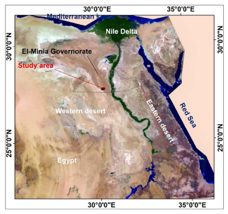
2.1. Study Area
2.2. Climate Factors
2.3. Experiment Design
2.4. Land Use Types and Crop Requirements
2.5. Interpolation Methods
2.6. Land Suitability Evaluation Model Steps
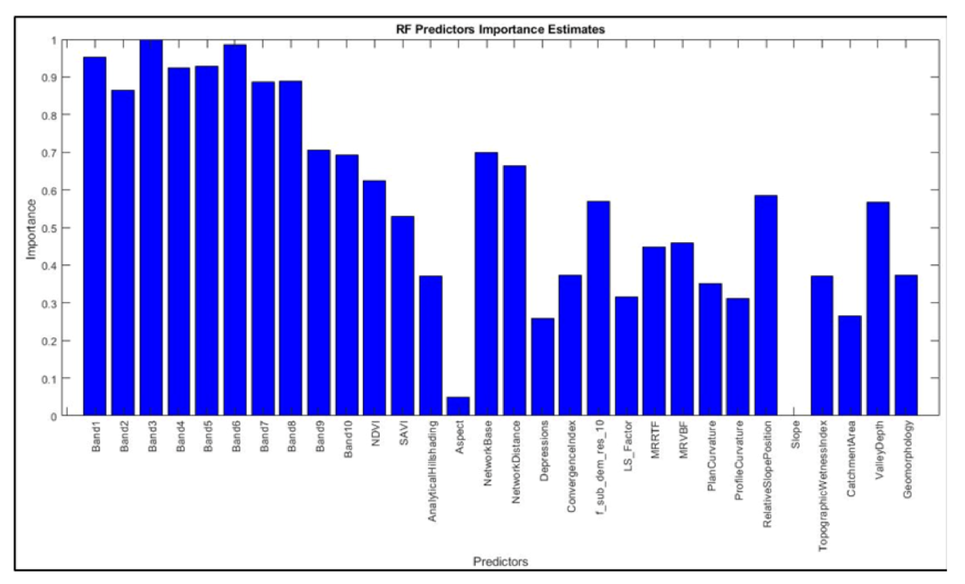
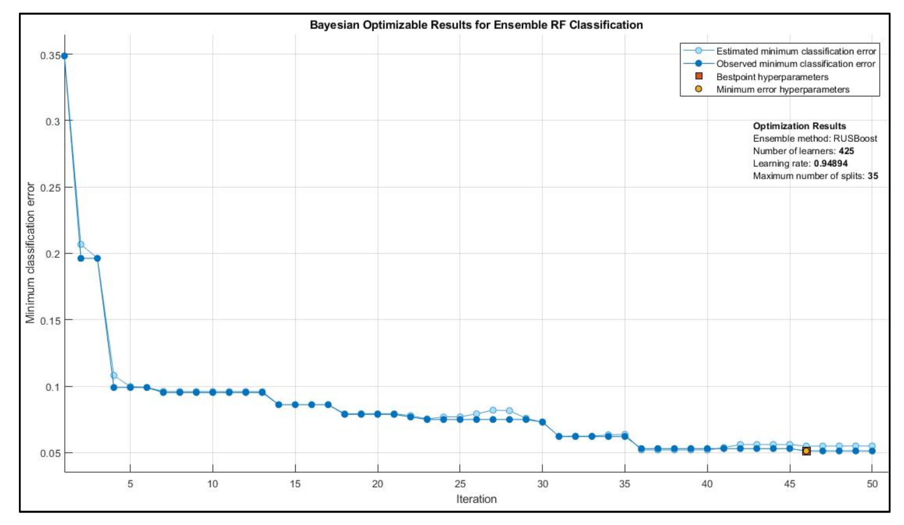
2.7. Estimating Land Suitability Classes Based on Machine Learning
3. Results
3.1. Land Form of the Study Area
3.2. Soil Taxonomy
- (1)
- Aridisols: Typic Haplocalcids, Calcic Haplosalids and Sodic Haplocalcids;
- (2)
- Entisols: Typic Torrifluvents, Typic Torripsamments and Typic Torriorthents.
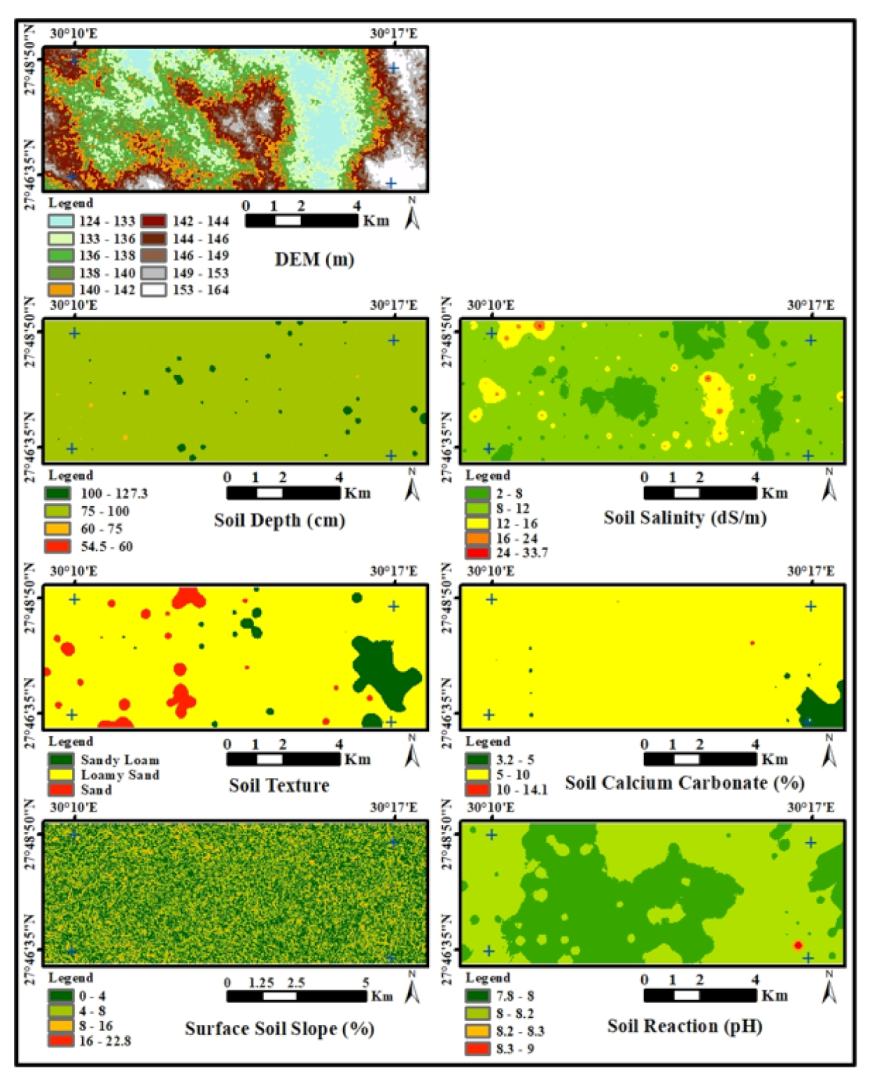
3.3. Spatial Variation of Physical and Chemical Criteria
3.3.1. Spatial Variation of the Soil Depth
3.3.2. Spatial Variation of the Soil Salinity
3.3.3. Spatial Variation of the Soil Texture
3.3.4. Spatial Variation of the Soil CaCO3
3.3.5. Spatial Variation of the Soil pH
3.3.6. Spatial Variation of the Slope
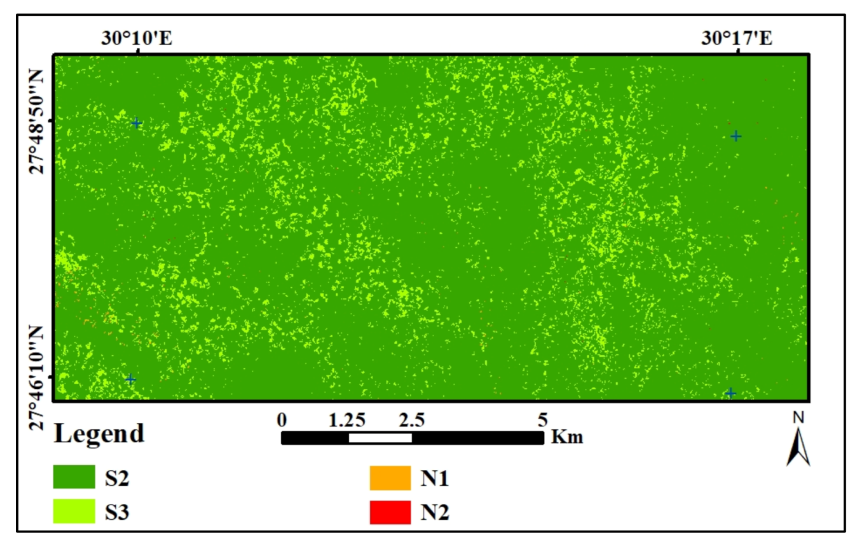
3.4. ML-Based Land Suitability Classes
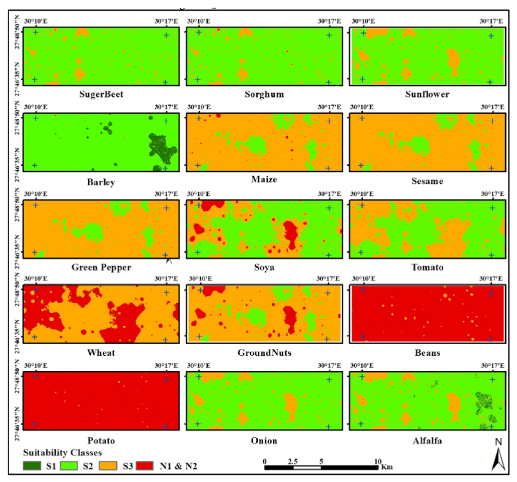
3.5. Description of the Selected Land Use Types
4. Discussion
5. Conclusions
Supplementary Materials
Author Contributions
Funding
Institutional Review Board Statement
Informed Consent Statement
Data Availability Statement
Acknowledgments
Conflicts of Interest
References
- AbdelRahman, M.A.E.; Natarajan, A.; Hegde, R. Assessment of land suitability and capability by integrating remote sensing and GIS for agriculture in Chamarajanagar district, Karnataka, India. Egypt. J. Remote Sens. Space Sci. 2016, 19, 125–141. [Google Scholar] [CrossRef] [Green Version]
- AbdelRahman, M.A.E.; Natarajan, A.; Srinivasamurthy, C.A.; Hegde, R. Estimating soil fertility status in physically degraded land using GIS and remote sensing techniques in Chamarajanagar district, Karnataka, India. Egypt. J. Remote Sens. Space Sci. 2016, 19, 95–108. [Google Scholar] [CrossRef] [Green Version]
- Mu, Y. Developing a suitability index for residential land use: A case study in Dianchi Drainage Area. Master’s Thesis, University of Waterloo, Waterloo, ON, Canada, 2006. [Google Scholar]
- He, Y.; Yao, Y.; Chen, Y.; Ongaro, L. Regional land suitability assessment for tree crops using remote sensing and GIS. In Proceedings of the IEEE Computer Distributed Control and Intelligent Environmental Monitoring (CDCIEM), Changsha, China, 19–20 February 2011; pp. 354–363. [Google Scholar]
- Beek, K.J.; De Bie, K.; Driessen, P. Land information and land evaluation for land use planning and sustainable land management. Land 1997, 1, 27–44. [Google Scholar]
- Merolla, S.; Armesto, G.; Calvanese, G. A GIS application for assessing agricultural land. ITC J. 1994, 1994, 264–269. [Google Scholar]
- Ali, R.R.; El-Kader, A.A.A.; Essa, E.F.; AbdelRahman, M.A.E. Application of remote sensing to determine spatial changes in soil properties and wheat productivity under salinity stress. Plant Arch. 2019, 19, 616–621. [Google Scholar]
- Rhoades, J.D.; Kandiah, A.; Mashali, A.M. The Use of Saline Waters for Crop Production; FAO Irrigation and Drainage Paper 48; FAO: Rome, Italy, 1992; Volume 133, pp. 52–67. [Google Scholar]
- Sys, C.; Van Ranst, E.; Debaveye, J. Land Evaluation. Part I: Principles in Land Evaluation and Crop Production Calculations; Agricultural Publication No. 7; GADC: Brussels, Belgium, 1991. [Google Scholar]
- AbdelRahman, M.A.E.; Arafat, S.M. An approach of agricultural courses for soil conservation based on crop soil suitability using geomatics. Earth Syst. Environ. 2020, 4, 273–285. [Google Scholar] [CrossRef]
- Bandyopadhyay, S.; Jaiswal, R.K.; Hegde, V.S.; Jayaraman, V. Assessment of land suitability potentials for agriculture using a remote sensing and GIS based approach. Int. J. Remote Sens. 2009, 30, 879–895. [Google Scholar] [CrossRef]
- Pan, G.; Pan, J. Research in crop land suitability analysis based on GIS. In Proceedings of the International Conference on Computer and Computing Technologies in Agriculture, Beijing, China, 29–31 October 2011; Springer: Berlin/Heidelberg, Germany, 2011; pp. 314–325. [Google Scholar]
- AbdelRahman, M.A.E.; Natarajan, A.; Hegde, R.; Prakash, S.S. Assessment of land degradation using comprehensive geostatistical approach and remote sensing data in GIS-model builder. Egypt. J. Remote Sens. Space Sci. 2019, 22, 323–334. [Google Scholar] [CrossRef]
- AbdelRahman, M.A.E.; Shalaby, A.; Essa, E.F. Quantitative land evaluation based on fuzzy-multi-criteria spatial model for sustainable land-use planning. Model. Earth Syst. Environ. 2018, 4, 1341–1353. [Google Scholar] [CrossRef]
- Dif, A.E.A. An Economic Study about Beet Sugar Manufacturing and Producing at Sharkia Governorate. Egypt. J. Agric. Econ. 2016, 26, 395–404. [Google Scholar]
- Taghizadeh-Mehrjardi, R.; Nabiollahi, K.; Rasoli, L.; Kerry, R.; Scholten, T. Land Suitability Assessment and Agricultural Production Sustainability Using Machine Learning Models. Agronomy 2020, 10, 573. [Google Scholar] [CrossRef]
- AL-Shdaifat, E.; Al-hassan, M.; Aloqaily, A. Effective heterogeneous ensemble classification: An alternative approach for selecting base classifiers. ICT Express 2020, 7, 342–349. [Google Scholar] [CrossRef]
- Seiffert, C.; Khoshgoftaar, T.M.; Hulse, J.V.; Napolitano, A. RUSBoost: Improving classification performance when training data is skewed. In Proceedings of the 2008 19th International Conference on Pattern Recognition, Tampa, FL, USA, 8–11 December 2008; pp. 1–4. [Google Scholar]
- Snoek, J.; Larochelle, H.; Adams, R.P. Practical Bayesian Optimization of Machine Learning Algorithms. Adv. Neural Inf. Process. Syst. 2012, 25, 2951–2959. [Google Scholar]
- Khaledian, Y.; Miller, B.A. Selecting appropriate machine learning methods for digital soil mapping. Appl. Math. Model. 2020, 81, 401–418. [Google Scholar] [CrossRef]
- Kornblyu, E.A.; Smirnova, S.F. FAO Guidelines for Soil Profile Description. Sov. Soil Sci.-USSR 2006, 2, 762. [Google Scholar]
- Sys, C.; Van Ranst, E.; Debavey, J.; Beernaert, F. Land Evaluation, Part III Crop Requirements; Agricultural Publication No. 7; General Administration for Development Cooperation: Gheut, Belgium, 1993. [Google Scholar]
- Zakarya, Y.M. Land Resources Assessment Using GIS, Expert Knowledge and Remote Sensing in the Desert Environment. Ph.D. Thesis, Faculty of Agriculture, Ain Shams University, Cairo, Egypt, 2009. [Google Scholar]
- AbdelRahman, M.A.E.; Zakarya, Y.M.; Metwaly, M.M.; Koubouris, G. Deciphering Soil Spatial Variability through Geostatistics and Interpolation Techniques. Sustainability 2021, 13, 194. [Google Scholar] [CrossRef]
- Yao, X.; Fu, B.; Lü, Y.; Sun, F.; Wang, S.; Liu, M. Comparison of four spatial interpolation methods for estimating soil moisture in a complex terrain catchment. PLoS ONE 2013, 8, e54660. [Google Scholar] [CrossRef]
- Metwaly, M.M. Sustainable Land use Planning of El-Qaa Plain, South Sinai, Egypt. J. Soil Sci. Agric. Eng. 2013, 2, 227–238. [Google Scholar]
- Behrens, T.; Schmidt, K.; Zhu, A.-X.; Scholten, T. The ConMap approach for terrain-based digital soil mapping. Eur. J. Soil Sci. 2010, 61, 133–143. [Google Scholar] [CrossRef]
- Nabiollahi, K.; Golmohammadi, F.; Taghizadeh-Mehrjardi, R.; Kerry, R. Assessing the e_ects of slope gradient and land use change on soil quality degradation through digital mapping of soil quality indices and soil loss rate. Geoderma 2018, 318, 482–494. [Google Scholar] [CrossRef]
- Nabiollahi, K.; Taghizadeh-Mehrjardi, M.; Eskandari, S. Assessing and monitoring the soil quality of forested and agricultural areas using soil-quality indices and digital soil-mapping in a semi-arid environment. Arch. Agron. Soil Sci. 2018, 64, 482–494. [Google Scholar] [CrossRef]
- Nabiollahi, K.; Eskandari, S.; Taghizadeh-Mehrjardi, R.; Kerry, R.; Triantafilis, J. Assessing soil organic carbon stocks under land use change scenarios using random forest models. Carbon Manag. 2019, 10, 63–77. [Google Scholar] [CrossRef]
- Taghizadeh-Mehrjardi, M.; Nabiollahi, K.; Minasny, B.; Triantafilis, J. Comparing data mining classifiers to predict spatial distribution of USDA-family soil groups in Baneh region, Iran. Geoderma 2015, 253, 67–77. [Google Scholar] [CrossRef]
- Taghizadeh-Mehrjardi, M.; Nabiollahi, K.; Kerry, R. Digital mapping of soil organic carbon at multiple depths using di_erent data mining techniques in Baneh region, Iran. Geoderma 2016, 266, 98–110. [Google Scholar] [CrossRef]
- Pahlavan-Rad, M.R.; Toomanian, N.; Khormali, F.; Brungard, C.W.; Komaki, C.B.; Bogaert, P. Updating soil survey maps using random forest and conditioned Latin hypercube sampling in the loess derived soils of northern Iran. Geoderma 2014, 232, 97–106. [Google Scholar] [CrossRef]
- Freden, S.C.; Mercanti, E.P.; Becker, M.A. (Eds.) Third Earth Resources Technology Satellite-1 Symposium; NASA Science and Technology Information: Washington, DC, USA, 1973; Volume 1, pp. 309–317.
- Huete, A.A. Soil-adjusted vegetation index (SAVI). Remote Sens. Environ. 1988, 25, 295–309. [Google Scholar] [CrossRef]
- Taghizadeh-Mehrjardi, R.; Sarmadian, F.; Minasny, B.; Triantafilis, J.; Omid, M. Digital mapping of soil classes using decision tree and auxiliary data in the Ardakan region, Iran. Arid Land Res. Manag. 2014, 213, 15–28. [Google Scholar] [CrossRef]
- Zeraatpisheh, M.; Ayoubi, S.; Jafari, A.; Finke, P. Comparing the e_ciency of digital and conventional soil mapping to predict soil types in a semi-arid region in Iran. Geomorphology 2017, 285, 186–204. [Google Scholar] [CrossRef]
- Olaya, V.A. Gentle Introduction to SAGA GIS; The SAGA User Group eV: Gottingen, Germany, 2004; p. 216. [Google Scholar]
- Rouse, J.W.; Hass, R.H.; Schell, J.A.; Deering, D.W. Monitoring vegetation systems in the Great Plains with ERTS. In Technical Presentations Section A Proceedings of the NASA SP-351; Third Earth Resources Technology Satellite-Symposium; NASA Special Publication: Washington, DC, USA, 1973. [Google Scholar]
- USDA. Keys to Soil Taxonomy, 11th ed.; The U.S. Department of Agriculture: Washington, DC, USA, 2003.
- Halder, J.C. Land suitability assessment for crop cultivation by using remote sensing and GIS. J. Geogr. Geol. 2013, 5, 65. [Google Scholar] [CrossRef]
- Mugiyo, H.; Chimonyo, V.G.P.; Sibanda, M.; Kunz, R.; Masemola, C.R.; Modi, A.T.; Mabhaudhi, T. Evaluation of Land Suitability Methods with Reference to Neglected and Underutilised Crop Species: A Scoping Review. Land 2021, 10, 125. [Google Scholar] [CrossRef]
- Trigoso, D.I.; López, R.S.; Briceño, N.B.R.; López, J.O.S.; Fernández, D.G.; Oliva, M.; Huatangari, L.Q.; Murga, R.E.T.; Castillo, E.B.; Gurbillón, M.Á.B. Land Suitability Analysis for Potato Crop in the Jucusbamba and Tincas Microwatersheds (Amazonas, NW Peru): AHP and RS–GIS Approach. Agronomy 2020, 10, 1898. [Google Scholar] [CrossRef]
- Alexakis, D.E.; Bathrellos, G.D.; Skilodimou, H.D.; Gamvroula, D.E. Land Suitability Mapping Using Geochemical and Spatial Analysis Methods. Appl. Sci. 2021, 11, 5404. [Google Scholar] [CrossRef]
- Azzam, M.A. Land suitability evaluation for cultivation of some soils in western desert of egypt, el-minya governorate using gis and remote sensing. Int. J. Adv. Res. 2016, 4, 486–503. [Google Scholar]
- Yossif, H.; Taher, M. Soil Classification and Optimum Agricultural Use for Some Areas at the Western Desert Fringe, El-Minia Governorate, Egypt. Alex. Sci. Exch. J. 2020, 41, 317–340. [Google Scholar] [CrossRef]
- Rashed, H.S.A. Classification and Mapping of Land Productivity, Capability and Suitability for Production Crops in West El-Minia Governorate, Egypt. J. Soil Sci. Agric. Eng. 2020, 11, 709–717. [Google Scholar]
- Mohamed, A.H.; Shendi, M.M.; Awadalla, A.A.; Mahmoud, A.G.; Semida, W.M. Land suitability modeling for newly reclaimed area using GIS-based multi-criteria decision analysis. Environ. Monit. Assess. 2019, 191, 1–13. [Google Scholar] [CrossRef]
- Aldababseh, A.; Temimi, M.; Maghelal, P.; Branch, O.; Wulfmeyer, V. Multi-criteria evaluation of irrigated agriculture suitability to achieve food security in an arid environment. Sustainability 2018, 10, 803. [Google Scholar] [CrossRef] [Green Version]
- Michalopoulos, G.; Kasapi, K.A.; Koubouris, G.; Psarras, G.; Arampatzis, G.; Hatzigiannakis, E.; Kavvadias, V.; Xiloyannis, C.; Montanaro, G.; Malliaraki, S. Adaptation of Mediterranean olive groves to climate change through sustainable cultivation practices. Climate 2020, 8, 54. [Google Scholar] [CrossRef] [Green Version]
- Montanaro, G.; Amato, D.; Briglia, N.; Russo, C.; Nuzzo, V. Carbon Fluxes in Sustainable Tree Crops: Field, Ecosystem and Global Dimension. Sustainability 2021, 13, 8750. [Google Scholar] [CrossRef]
- Hamadttu, A.F.E. Insect Pest Management in Organic Farming System, Multifunctionality and Impacts of Organic and Conventional Agriculture; Moudrý, J., Mendes, K.F., Bernas, J., da Teixeira, R.S., de Sousa, R.N., Eds.; IntechOpen: London, UK, 2019. [Google Scholar]
- Blake, L. Protection and Pest Management; Extension Implementation Program Grant No. 2017-70006-27200/Project Accession No. 1014037; The USDA National Institute of Food and Agriculture: Washington, DC, USA, 2019.
- Alyokhin, A.; Nault, B.; Brown, B. Soil conservation practices for insect pest management in highly disturbed agroecosystems—A review; Special Issue: Insects in Agroecosystems, The Netherlands Entomological Society. Entomol. Exp. Appl. 2020, 168, 7–27. [Google Scholar] [CrossRef]
- Leteinturier, B.; Herman, J.; Longueville, F.D.; Quintin, L.; Oger, R. Adaptation of a crop sequence indicator based on a land parcel management system. Agric. Ecosyst. Environ. 2006, 112, 324–334. [Google Scholar] [CrossRef]
- Singha, C.; Swain, K.C. Land Suitability Evaluation Criteria for Agricultural crop selection: A Review. Agric. Rev. 2016, 37, 125–132. [Google Scholar] [CrossRef] [Green Version]
- Lenz-Wiedemann, V.I.S.; Klar, C.W.; Schneider, K. Development and test of a crop growth model for application within a Global Change decision support system. Ecol. Model. 2010, 221, 314–329. [Google Scholar] [CrossRef]
- Lorenz, M.; Fürst, C.; Thiel, E. A methodological approach for deriving regional crop rotations as basis for the assessment of the impact of agricultural strategies using soil erosion as example. J. Environ. Manag. 2013, 127, S37–S47. [Google Scholar] [CrossRef]
- Abuzaid, A.S.; Jahin, H.S.; Asaad, A.A.; Fadl, M.E.; AbdelRahman, M.A.E.; Scopa, A. Accumulation of Potentially Toxic Metals in Egyptian Alluvial Soils, Berseem Clover (Trifolium alexandrinum L.), and Groundwater after Long-Term Wastewater Irrigation. Agriculture 2021, 11, 713. [Google Scholar] [CrossRef]
- Abuzaid, A.S.; AbdelRahman, M.A.E.; Fadl, M.E.; Scopa, A. Land Degradation Vulnerability Mapping in a Newly-Reclaimed Desert Oasis in a Hyper-Arid Agro-Ecosystem Using AHP and Geospatial Techniques. Agronomy 2021, 11, 1426. [Google Scholar] [CrossRef]
- AbdelRahman, M.A.E.; Rehab, H.H.; Yossif, T.M.H. Soil fertility assessment for optimal agricultural use using remote sensing and GIS technologies. Appl. Geomat. 2021. [Google Scholar] [CrossRef]
- Mahmoudzadeh, H.; Matinfar, H.R.; Taghizadeh-Mehrjardi, R.; Kerry, R. Spatial prediction of soil organic carbon using machine learning techniques in western Iran. Geoderma Reg. 2020, 21, e00260. [Google Scholar] [CrossRef]
- Waldhoff, G.; Lussem, U.; Bareth, G. Multi-data approach for remote sensing-based regional crop rotationmapping: A case study for the Rur catchment, Germany. Int. J. Appl. Earth Obs. Geoinf. 2017, 61, 55–69. [Google Scholar] [CrossRef]
- Jayanth, J.; Aravind, R.; Amulya, C.M. Classification of Crops and Crop Rotation Using Remote Sensing and GIS-Based Approach: A Case Study of Doddakawalande Hobli, Nanjangudu Taluk. J. Indian Soc. Remote Sens. 2021. [Google Scholar] [CrossRef]
- Schönhart, M.; Schmid, E.; Schneider, U.A. CropRota—A crop rotation model to support integrated land use assessments. Eur. J. Agron. 2011, 34, 263–277. [Google Scholar] [CrossRef]
- Waldhoff, G.; Curdt, C.; Hoffmeister, D.; Bareth, G. Analysis of multitemporal and multisensor remote sensing data for crop rotation mapping. ISPRS Ann. Photogramm. Remote Sens. Spat. Inf. Sci. 2012, 1, 177–182. [Google Scholar] [CrossRef] [Green Version]
- Hütt, C.; Koppe, W.; Miao, Y.; Bareth, G. Best accuracy land use/land cover (LULC) classification to derive crop types using multitemporal, multisensor, and multi-polarization SAR satellite images. Remote Sens. 2006, 8, 684. [Google Scholar] [CrossRef] [Green Version]
- Waldner, F.; Canto, G.S.; Defourny, P. Automated annual cropland mapping using knowledge-based temporal features. ISPRS J. Photogramm. Remote Sens. 2015, 110, 1–13. [Google Scholar] [CrossRef]
- Wilson, H.M.; Al-Kaisi, M.M. Crop rotation and nitrogen fertilization effect on soil CO2 emissions in central Iowa. Appl. Soil Ecol. 2008, 39, 264–270. [Google Scholar] [CrossRef]
- Casasnovas, M.J.; Martin-Monetero, A.; Casterad, M.A. Mapping multi-year cropping patterns in small irrigation districts from time series analysis of Landsat TM images. Eur. J. Agron. 2005, 23, 159–169. [Google Scholar] [CrossRef]
- Jamil, M.; Sajjad, H. Deriving cropping system efficiency pattern using remote sensing and GIS: A case study of Bijnor district, India. Int. J. Adv. Remote Sens. GIS Geogr. 2016, 4, 27–40. [Google Scholar]
- Blaes, L.; Vanhalle, P. Defourny Efficiency of crop identification based on optical and SAR image time series. Remote Sens. Environ. 2005, 96, 352–365. [Google Scholar] [CrossRef]


| Month | Average Temperature °C | Rainfall mm | Relative | Evaporation mm/Day | Wind Speed (Knots) | ||
|---|---|---|---|---|---|---|---|
| Mean Temp. °C | Min °C | Max °C | Humidity % | ||||
| January | 11.9 | 4.6 | 20.4 | 1.1 | 65 | 4 | 4.7 |
| February | 13.5 | 5.6 | 22 | 1.7 | 58.8 | 5.4 | 5.4 |
| March | 16.9 | 8.6 | 25.4 | 3.4 | 53.9 | 7.2 | 6.6 |
| April | 21.9 | 12.8 | 30.9 | 0.5 | 44.9 | 10.9 | 7.2 |
| May | 26.3 | 17.2 | 35 | 1.4 | 39.1 | 13.8 | 7.8 |
| June | 28.5 | 19.9 | 36.7 | 0 | 41.8 | 14.6 | 8.6 |
| July | 29.2 | 21.1 | 36.9 | 0 | 48.4 | 12.6 | 6.2 |
| August | 28.6 | 21 | 36.2 | 0 | 52.8 | 10.5 | 5.6 |
| September | 26.9 | 19.4 | 34.7 | 0 | 53.1 | 9.9 | 6.8 |
| October | 23.3 | 16.1 | 31.2 | 0 | 56.9 | 8.1 | 5.8 |
| November | 17.7 | 10.7 | 25.9 | 3.5 | 63.4 | 5.2 | 4.9 |
| December | 13.1 | 6.1 | 21.4 | 2.1 | 67.5 | 3.5 | 4.1 |
| Mean | 21.48 | 13.59 | 29.72 | 1.14 | 53.8 | 8.8 | 6.14 |
| Landform Unit | Area | |
|---|---|---|
| (Hectare) | (%) | |
| Loamy sand soil, Undulated topography | 3019.22 | 31.63 |
| Loamy sand soil, Nearly level topography | 2058.67 | 21.57 |
| Sandy soil, Nearly level topography | 1224.57 | 12.83 |
| Sandy loam soil, Undulated topography | 3242.79 | 33.97 |
| ECe (dS/m) | Area | |
|---|---|---|
| (Hectare) | (%) | |
| 2–8 | 872.95 | 12.65 |
| 8–12 | 5558.19 | 80.55 |
| 12–16 | 469.36 | 6.80 |
| 16–24 | 33.94 | 0.49 |
| 24–33.7 | 1.19 | 0.02 |
| pH | Area | |
| (Hectare) | (%) | |
| 7.8–8 | 2993.61 | 43.20 |
| 8–8.2 | 3926.28 | 56.66 |
| 8.2–8.3 | 10.09 | 0.15 |
| 8.3–9 | 5.64 | 0.08 |
| Slope (%) | Area | |
| (Hectare) | (%) | |
| 0–4 | 3319.86 | 47.72 |
| 4–8 | 3121.64 | 44.87 |
| 8–16 | 515.91 | 7.42 |
| 16–22.8 | 1.69 | 0.02 |
| Soil Depth (cm) | Area | |
| (Hectare) | (%) | |
| 54.5–60 | 0.06 | 0.00 |
| 60–75 | 8.78 | 0.13 |
| 75–100 | 6835.75 | 99.87 |
| 100–127.3 | 91.03 | 1.33 |
| CaCO3 (%) | Area | |
| (Hectare) | (%) | |
| 3.2–5 | 194.30 | 2.80 |
| 5–10 | 6739.48 | 97.17 |
| 10–14.1 | 1.84 | 0.03 |
| Texture | Area | |
| (Hectare) | (%) | |
| S | 295.13 | 4.27 |
| LS | 6127.64 | 88.65 |
| SL | 489.42 | 7.08 |
| Predicted Class | |||||
|---|---|---|---|---|---|
| True Class | Class N2 | Class N1 | Class S3 | Class S2 | |
| Class N2 | 100.00% | ||||
| Class N1 | 100.00% | ||||
| Class S2 | 86.90% | 7.60% | |||
| Class S2 | 13.10% | 92.40% | |||
| Suitability Class | Area | |
|---|---|---|
| (Hectare) | (%) | |
| S2 | 8755.47 | 92.15 |
| S3 | 737.19 | 7.76 |
| N1 | 8.29 | 0.09 |
| N2 | 0.57 | 0.01 |
| Suitability Class | Area | |
|---|---|---|
| (Hectare) | (%) | |
| S1 | 10.77 | 0.16 |
| S2 | 6111.27 | 88.11 |
| S3 | 810.72 | 11.69 |
| N | 2.88 | 0.04 |
| Crops | Area | Soil Suitability Classes | |||
|---|---|---|---|---|---|
| S1 | S2 | S3 | N1 | ||
| Alfalfa | (Hectare) | 157.39 | 5547.23 | 1229.31 | 1.69 |
| (%) | 2.27 | 79.98 | 17.72 | 0.02 | |
| Barely | (Hectare) | 471.45 | 6415.30 | 46.38 | 2.50 |
| (%) | 6.80 | 92.50 | 0.67 | 0.04 | |
| Beans | (Hectare) | - | 0.47 | 81.67 | 6853.48 |
| (%) | - | 0.01 | 1.18 | 98.82 | |
| Green pepper | (Hectare) | 0.47 | 807.16 | 6126.31 | 1.69 |
| (%) | 0.01 | 11.64 | 88.33 | 0.02 | |
| Groundnut | (Hectare) | 0.31 | 781.81 | 5646.28 | 507.22 |
| (%) | 0.00 | 11.27 | 81.41 | 7.31 | |
| Maize | (Hectare) | 0.02 | 782.11 | 6116.67 | 36.83 |
| (%) | 0.00 | 11.28 | 88.19 | 0.53 | |
| Onion | (Hectare) | 0.14 | 5704.48 | 1229.31 | 1.69 |
| (%) | 0.00 | 82.25 | 17.72 | 0.02 | |
| Potato | (Hectare) | - | 1.03 | 17.73 | 6916.86 |
| (%) | - | 0.01 | 0.26 | 99.73 | |
| Sesame | (Hectare) | - | 782.13 | 6151.81 | 1.69 |
| (%) | - | 11.28 | 88.70 | 0.02 | |
| Sorghum | (Hectare) | 10.77 | 6111.27 | 806.63 | 6.97 |
| (%) | 0.16 | 88.11 | 11.63 | 0.10 | |
| Soya | (Hectare) | 0.08 | 3971.08 | 2458.38 | 506.09 |
| (%) | 0.00 | 57.26 | 35.45 | 7.30 | |
| Sugar beet | (Hectare) | 10.77 | 6111.27 | 810.72 | 2.88 |
| (%) | 0.16 | 88.11 | 11.69 | 0.04 | |
| Sunflower | (Hectare) | - | 5699.95 | 1233.98 | 1.69 |
| (%) | - | 82.18 | 17.79 | 0.02 | |
| Tomato | (Hectare) | - | 3967.64 | 2966.30 | 1.69 |
| (%) | - | 57.21 | 42.77 | 0.02 | |
| Wheat | (Hectare) | - | 0.09 | 4503.64 | 2431.89 |
| (%) | - | 0.00 | 64.93 | 35.06 | |
| No. | Crop Name | Species | Planting Date | Planting Period (Months) | Selected Suitability Performance |
|---|---|---|---|---|---|
| 1 | Sugar beet | Beta vulgaris | Aug.–Sep.–Mid. Oct. | 6–7 | S2 > S3 |
| 2 | Sorghum | Sorghum bicolor | Mid. Apr. | 4 | S2 > S3 |
| 3 | Sunflower | Helianthus annuus | Apr.–Jun. | 3 | S2 > S3 |
| 4 | Barley | Hordeum vulgare | Mid. Nov.–Mid. Dec. | 5–6 | S1 < S2 |
| 5 | Maize | Zeamais | Mid Apr. | 4 | S2 < S3 |
| 6 | Sesame | Sesamum indicum | Apr. | 3 | S2 < S3 |
| 7 | Green pepper | Capsicum annuum | First Aug.–Sep. Early second Feb.–Mar. | 4–6 | S2 < S3 |
| 8 | Soya | Glycine maximum | Apr. | 4 | S2 > S3 |
| 9 | Tomato | Solanum lycopersicum esculentum | Early summer Dec.–Jan. Summer Feb.–Mar. | 3–4 | S2 > S3 |
| 10 | Wheat | Triticum aestivum | Mid. Nov. | 6 | S3 > N1 |
| 11 | Groundnuts | Arachis hypogaea | Apr.–May | 4–5 | S2 < S3 |
| 12 | Beans | Phaseolus vulgare | Mid. Oct. | 5 | N1 |
| 13 | Potato | Solanum tuberosum | Sep.–Oct. | 4 | N1 |
| 14 | Onion | Allium cepa | Oct. | 3–5 | S2 > S3 |
| 15 | Alfalfa | Medicago sativa | Mid. Sep.–Mid. Oct. | 4–5 | S2 > S3 |
Publisher’s Note: MDPI stays neutral with regard to jurisdictional claims in published maps and institutional affiliations. |
© 2021 by the authors. Licensee MDPI, Basel, Switzerland. This article is an open access article distributed under the terms and conditions of the Creative Commons Attribution (CC BY) license (https://creativecommons.org/licenses/by/4.0/).
Share and Cite
Zakarya, Y.M.; Metwaly, M.M.; AbdelRahman, M.A.E.; Metwalli, M.R.; Koubouris, G. Optimized Land Use through Integrated Land Suitability and GIS Approach in West El-Minia Governorate, Upper Egypt. Sustainability 2021, 13, 12236. https://doi.org/10.3390/su132112236
Zakarya YM, Metwaly MM, AbdelRahman MAE, Metwalli MR, Koubouris G. Optimized Land Use through Integrated Land Suitability and GIS Approach in West El-Minia Governorate, Upper Egypt. Sustainability. 2021; 13(21):12236. https://doi.org/10.3390/su132112236
Chicago/Turabian StyleZakarya, Yasser M., Mohamed M. Metwaly, Mohamed A. E. AbdelRahman, Mohamed R. Metwalli, and Georgios Koubouris. 2021. "Optimized Land Use through Integrated Land Suitability and GIS Approach in West El-Minia Governorate, Upper Egypt" Sustainability 13, no. 21: 12236. https://doi.org/10.3390/su132112236
APA StyleZakarya, Y. M., Metwaly, M. M., AbdelRahman, M. A. E., Metwalli, M. R., & Koubouris, G. (2021). Optimized Land Use through Integrated Land Suitability and GIS Approach in West El-Minia Governorate, Upper Egypt. Sustainability, 13(21), 12236. https://doi.org/10.3390/su132112236