Integrating Remote Sensing, Machine Learning, and Citizen Science in Dutch Archaeological Prospection


Abstract
:
1. Introduction
1.1. Remote Sensing in Archaeological Prospection
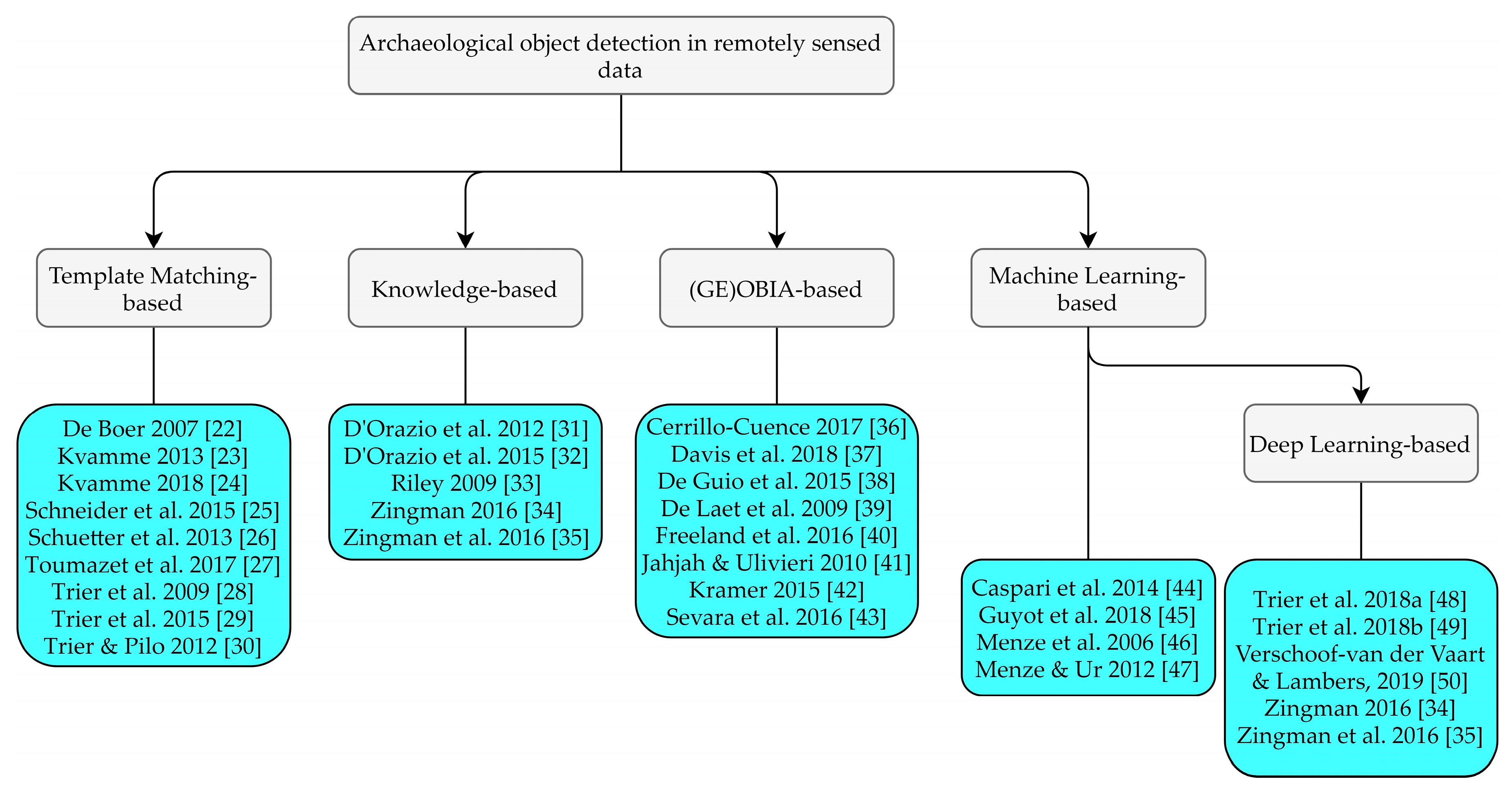
1.2. Archaeological Object Detection
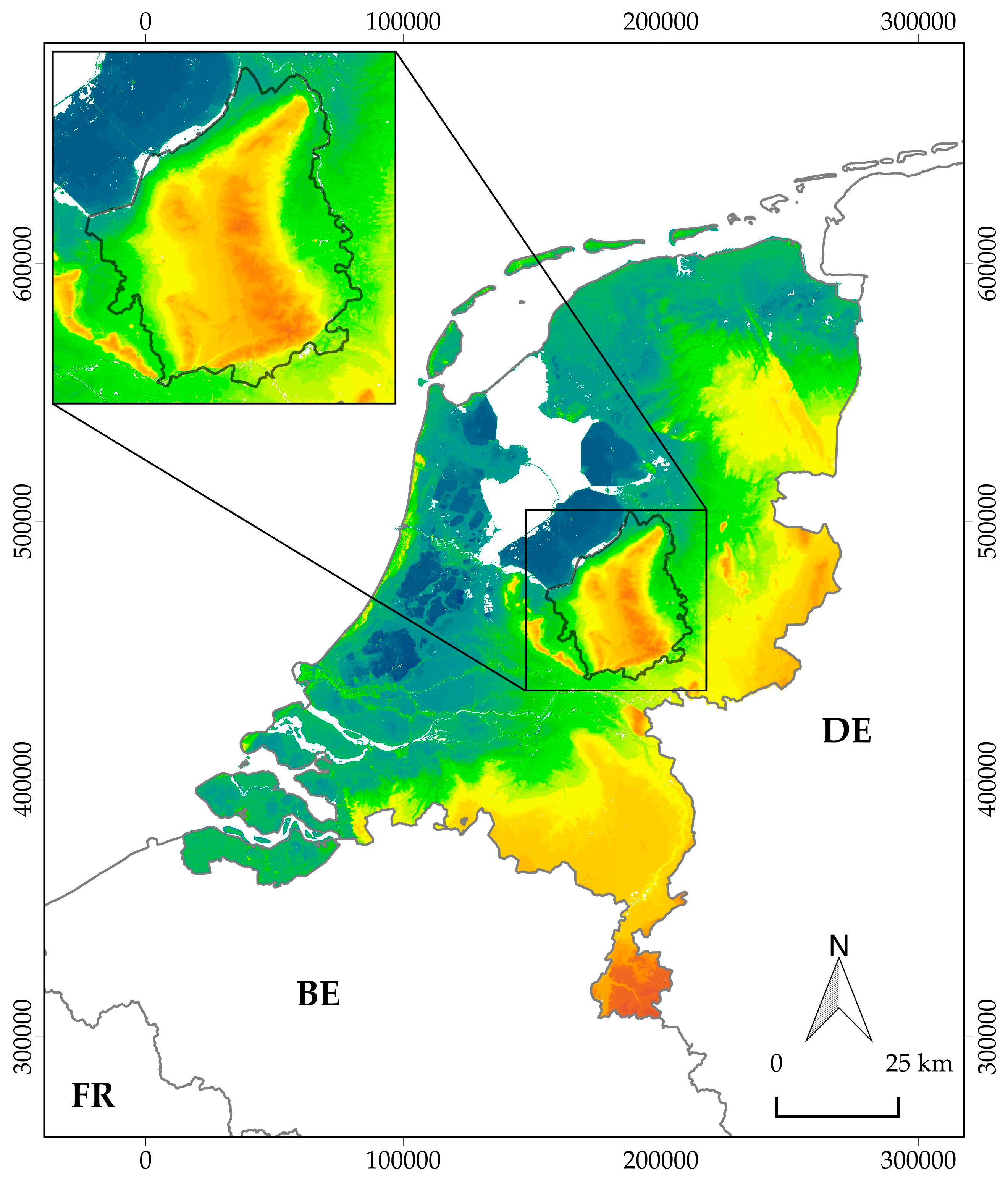
1.3. The Research Area and Current Research Strategy
1.4. Outline of This Paper
2. New Data Sources and Methods
2.1. Multi-Class Object Detection in Remotely Sensed Data Using Deep Learning
2.2. Creation of (Training) Datasets
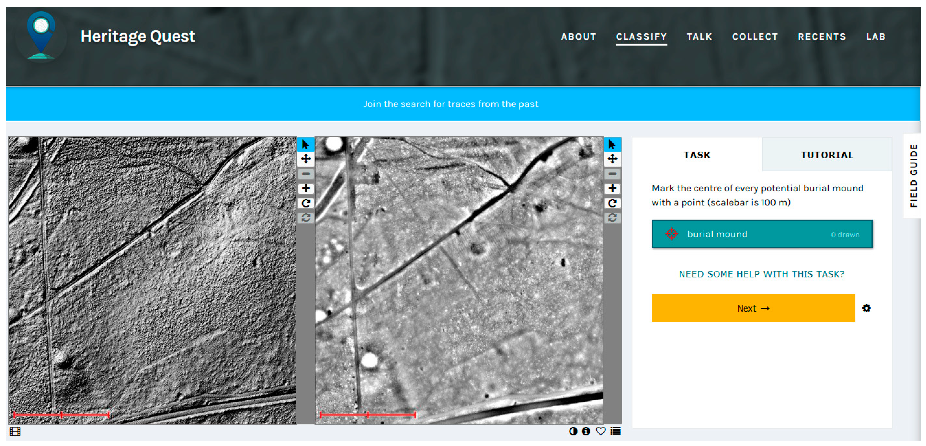
2.3. Citizen Science
3. Implementation and Results
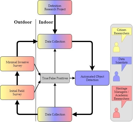
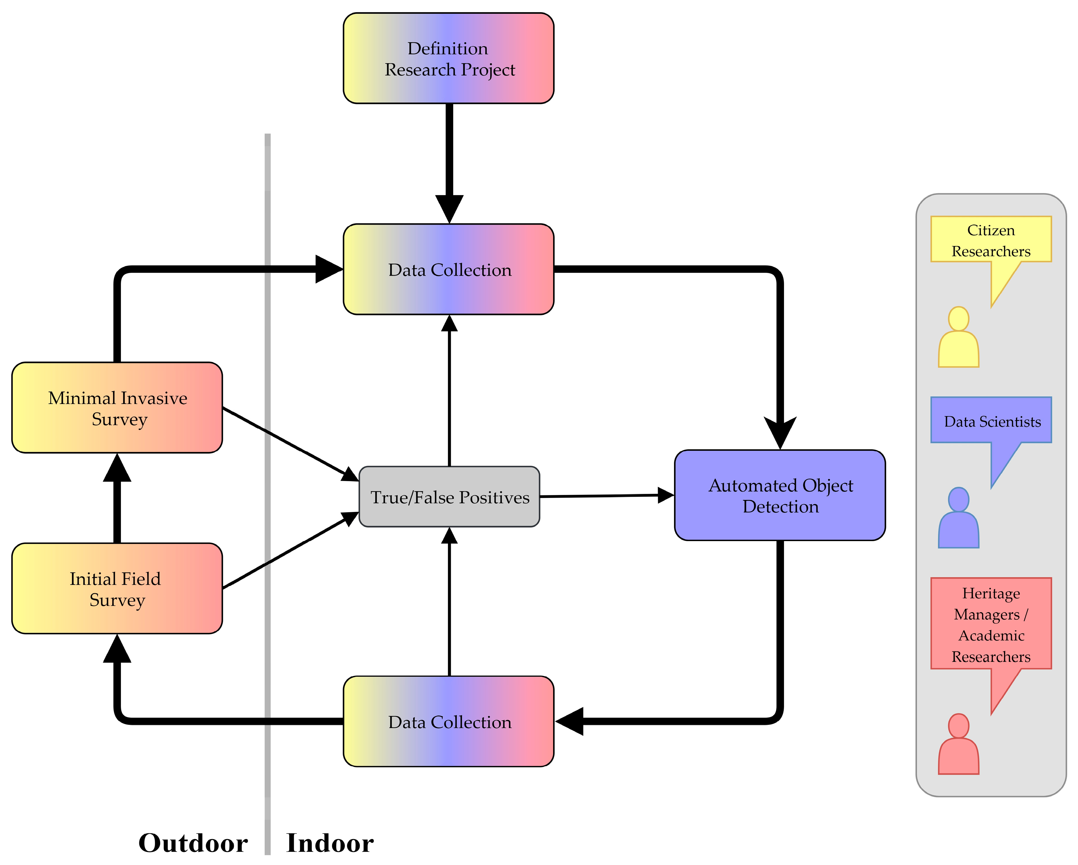
3.1. An Integrated Approach for Dataset Generation and Validation
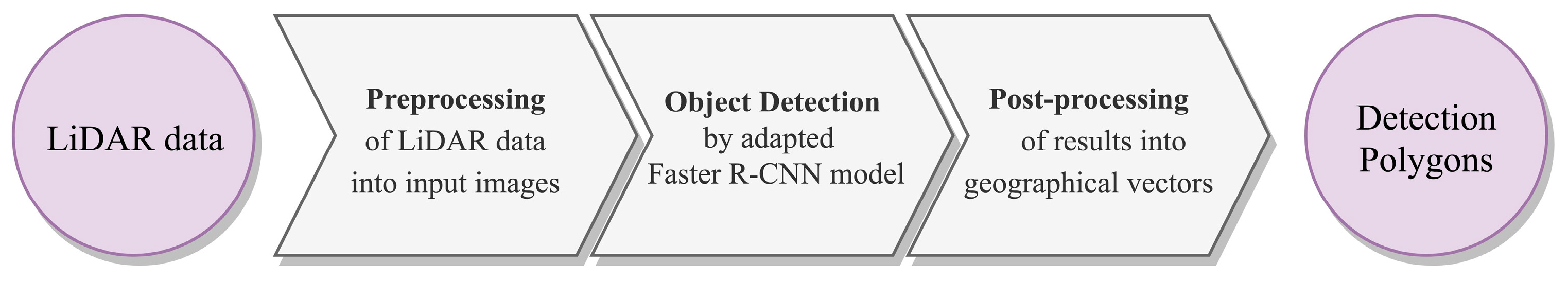
3.1.1. Data Collection and Automated Object Detection Steps
3.1.2. Validation Steps
3.2. Case Study: Using the Integrated Approach in Studying Archaeological Landscapes on the Veluwe
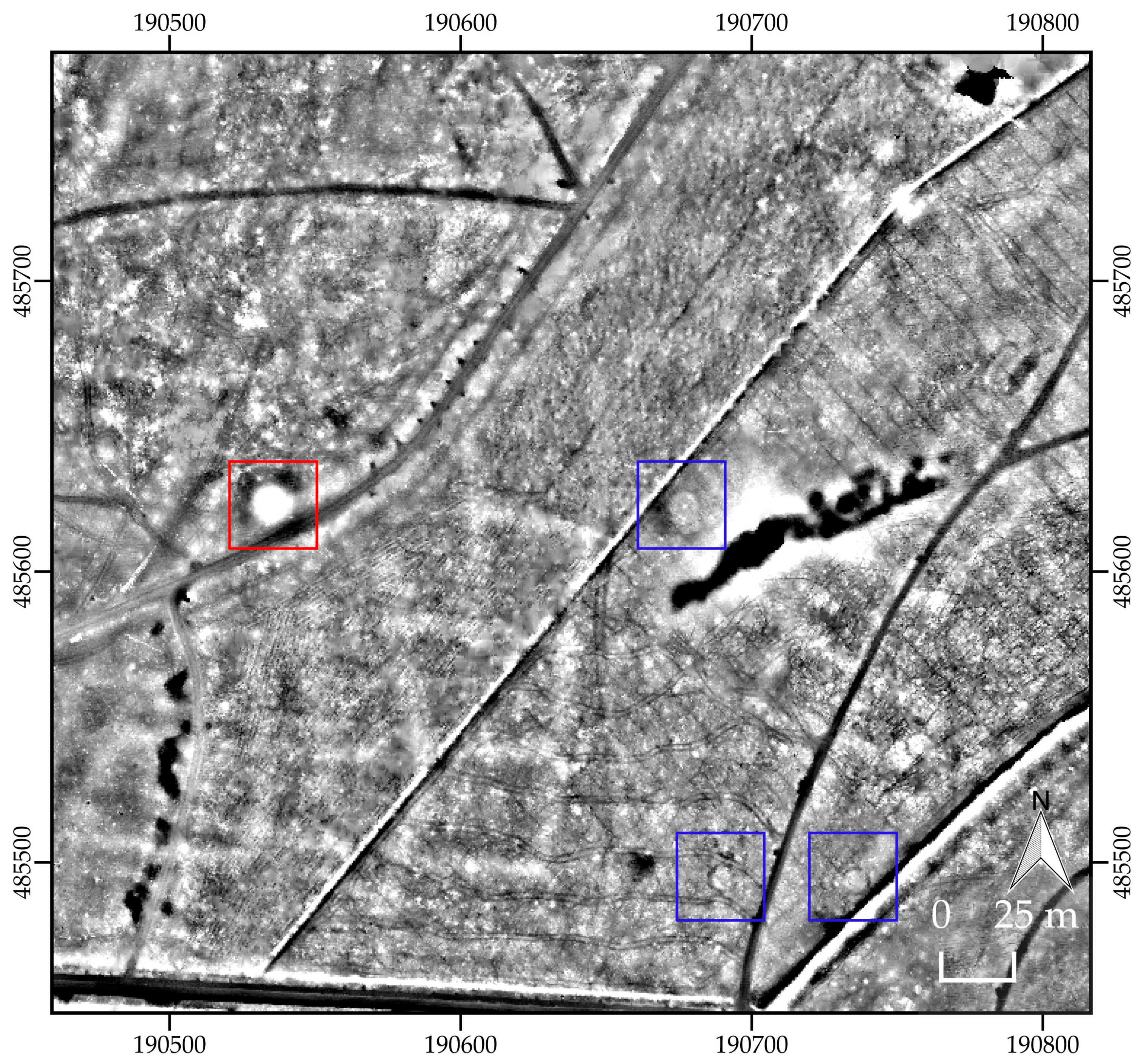
3.2.1. Data Collection and Object Detection: The Zooniverse and WODAN
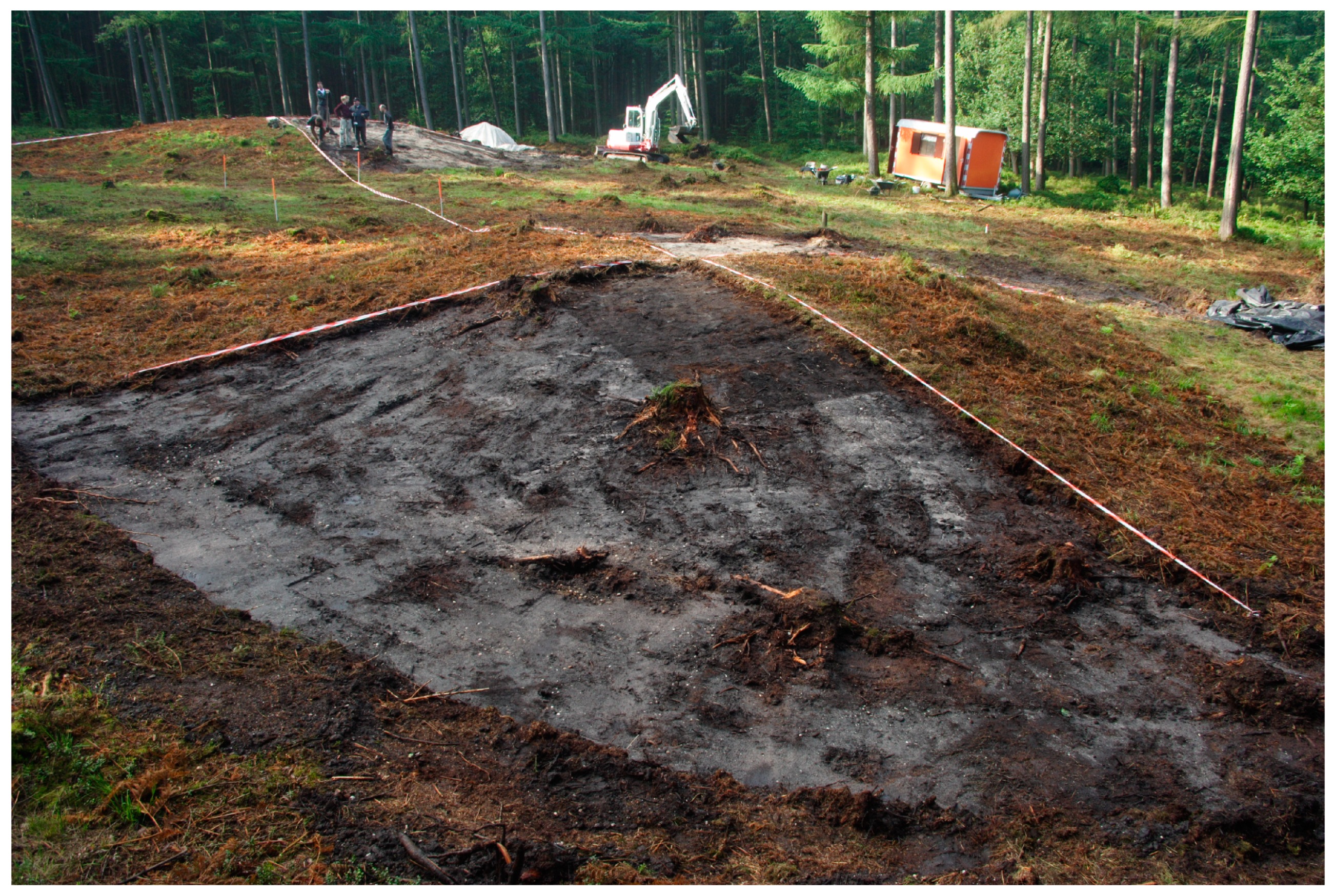
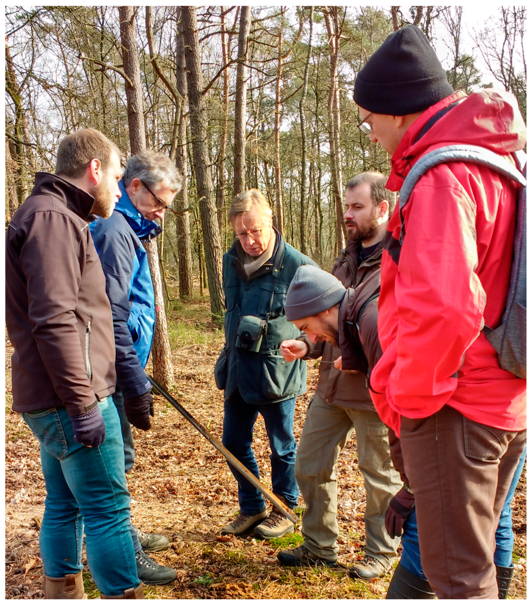
3.2.2. Validation: Field Expeditions and Coring Campaigns
4. Discussion
5. Conclusions
Author Contributions
Funding
Acknowledgments
Conflicts of Interest
References
- Bennett, R.; Cowley, C.; De Laet, V. The data explosion: Tackling the taboo of automatic feature recognition in airborne survey data. Antiquity 2014, 88, 896–905. [Google Scholar] [CrossRef]
- Bevan, A. The data deluge. Antiquity 2015, 89, 1473–1484. [Google Scholar] [CrossRef]
- Cowley, D. Remote Sensing for Archaeological Heritage Management; Europae Archaeologia Consilium: Brussels, Belgium, 2011; ISBN 9789639911208. [Google Scholar]
- Banaszek, Ł.; Cowley, D.C.; Middleton, M. Towards national archaeological mapping. Assessing source data and methodology—A case study from Scotland. Geosciences 2018, 8, 272. [Google Scholar] [CrossRef]
- Corsi, C.; Slapšak, B.; Vermeulen, F. Good Practice in Archaeological Diagnostics: Non-invasive Survey of Complex Archaeological Sites; Springer: Cham, Switzerland, 2013; ISBN 9783319017839. [Google Scholar]
- Doneus, M. Die hinterlassene Landschaft—Prospektion und Interpretation in der Landschaftsarchäologie; Austrian Academy of Sciences: Vienna, Austria, 2013; ISBN 9783700171973. [Google Scholar]
- Sarris, A. Best Practices of Geoinformatic Technologies for the Mapping of Archaeological Landscapes; Archaeopress: Oxford, UK, 2015; ISBN 9781784911621. [Google Scholar]
- Trinks, I.; Hinterleitner, A.; Neubauer, W.; Nau, E.; Löcker, K.; Wallner, M.; Gabler, M.; Filzwieser, R.; Wilding, J.; Schiel, H.; et al. Large-area high-resolution ground-penetrating radar measurements for archaeological prospection. Archaeol. Prospect. 2018, 25, 171–195. [Google Scholar] [CrossRef]
- Musson, C.; Palmer, R.; Campana, S. Flights into the Past: Aerial Photography, Photo Interpretation and Mapping for Archaeology; Aerial Archaeology Research Group and Universitätsbibliothek Heidelberg: Heidelberg, Germany, 2013; ISBN 9783000444791. Available online: http://nbn-resolving.de/urn:nbn:de:bsz:16-propylaeumdok-20096 (accessed on 26 February 2019).
- Verhoeven, G.J. Are we there yet? A review and assessment of archaeological passive airborne optical imaging approaches in the light of landscape archaeology. Geosciences 2017, 7, 86. [Google Scholar] [CrossRef]
- Lillesand, T.M.; Kiefer, R.W.; Chipman, J.W. Remote Sensing and Image Interpretation, 7th ed.; Wiley: Hoboken, NJ, USA, 2015; ISBN 9781118343289. [Google Scholar]
- Richards, J.A. Remote Sensing Digital Image Analysis, 5th ed.; Springer: Berlin/Heidelberg, Germany, 2013; ISBN 9783642300615. [Google Scholar]
- Jensen, J.R. Introductory Digital Image Processing: A Remote Sensing Perspective, 4th ed.; Pearson: Glenview, IL, USA, 2015; ISBN 9780134058160. [Google Scholar]
- Chen, G.; Han, J. A survey on object detection in optical remote sensing images. ISPRS J. Photogramm. Remote Sens. 2016, 117, 11–18. [Google Scholar] [CrossRef]
- De Laet, V.; Lambers, K. Archaeological prospecting using high-resolution digital satellite imagery: Recent advances and future prospects—A session held at the Computer Applications and Quantitative Methods in Archaeology (CAA) conference, Williamsburg, USA, March 2009. AARGnews—Newsl. Aer. Archaeol. Res. Group 2009, 39, 9–17. Available online: http://nbn-resolving.de/urn:nbn:de:bsz:352-opus-100818 (accessed on 26 February 2019).
- Brophy, K.; Cowley, D. From the Air: Understanding Aerial Archaeology; Tempus: Stroud, UK, 2005; ISBN 9780752431307. [Google Scholar]
- Traviglia, A.; Cowley, D.; Lambers, K. Finding common ground: Human and computer vision in archaeological prospection. AARGnews—Newsl. Aer. Archaeol. Res. Group 2016, 53, 11–24. Available online: http://hdl.handle.net/1887/43751 (accessed on 1 October 2018).
- Cowley, D.C. In with the new, out with the old? Auto-extraction for remote sensing archaeology. Proc. SPIE 2012, 8532, 853206. [Google Scholar] [CrossRef]
- Cowley, D.C. What do the patterns mean? Archaeological distributions and bias in survey data. In Digital Methods and Remote Sensing in Archaeology: Archaeology in the Age of Sensing; Forte, M., Campana, S., Eds.; Springer: Cham, Switzerland, 2016; pp. 147–170. ISBN 9783319406565. [Google Scholar]
- Lambers, K.; Traviglia, A. Automated detection in remote sensing archaeology: A reading list. AARGnews—Newsl. Aer. Archaeol. Res. Group 2016, 53, 25–29. Available online: http://hdl.handle.net/1887/43750 (accessed on 26 February 2019).
- Lambers, K. Airborne and spaceborne remote sensing and digital image analysis in archaeology. In Digital Geoarchaeology: New Techniques for Interdisciplinary Human-Environmental Research; Siart, C., Forbriger, M., Bubenzer, O., Eds.; Springer: Cham, Switzerland, 2018; pp. 109–122. ISBN 9783319253145. [Google Scholar]
- De Boer, A. Using pattern recognition to search LIDAR data for archaeological sites. In The World Is in Your Eyes: Proceedings of the XXXIII Computer Applications and Quantitative Methods in Archaeology Conference (March 2005—Tomar, Portugal); Figueiredo, A., Velho, G., Eds.; CAAPortugal: Tomar, Portugal, 2007; pp. 245–254. ISBN 97898995313. [Google Scholar]
- Kvamme, K.L. An examination of automated archaeological feature recognition in remotely sensed imagery. In Computational Approaches to Archaeological Spaces; Bevan, A., Lake, M., Eds.; Left Coast Press: Walnut Creek, CA, USA, 2013; pp. 53–68. ISBN 9781611323467. [Google Scholar]
- Kvamme, K.L. Experiments in the automatic detection of archaeological features in remotely sensed data from Great Plains villages, USA. In CAA2016: Oceans of Data. Proceedings of the 44th Conference on Computer Applications and Quantitative Methods in Archaeology; Matsumoto, M., Uleberg, E., Eds.; Archaeopress: Oxford, UK, 2018; pp. 173–184. ISBN 9781784917302. [Google Scholar]
- Schneider, A.; Takla, M.; Nicolay, A.; Raab, A.; Raab, T. A template-matching approach combining morphometric variables for automated mapping of charcoal kiln sites. Archaeol. Prospect. 2015, 22, 45–62. [Google Scholar] [CrossRef]
- Schuetter, J.; Goel, P.; McCorriston, J.; Park, J.; Senn, M.; Harrower, M. Autodetection of ancient Arabian tombs in high-resolution satellite imagery. Int. J. Remote Sens. 2013, 34, 6611–6635. [Google Scholar] [CrossRef]
- Toumazet, J.; Vautier, F.; Roussel, E.; Dousteyssier, B. Automatic detection of complex archaeological grazing structures using airborne laser scanning data. J. Archaeol. Sci. Rep. 2017, 12, 569–579. [Google Scholar] [CrossRef]
- Trier, Ø.D.; Larsen, S.; Solberg, R. Automatic detection of circular structures in high-resolution satellite images of agricultural land. Archaeol. Prospect. 2009, 16, 1–15. [Google Scholar] [CrossRef]
- Trier, Ø.D.; Zortea, M.; Tonning, C. Automatic detection of mound structures in airborne laser scanning data. J. Archaeol. Sci. Rep. 2015, 2, 69–79. [Google Scholar] [CrossRef]
- Trier, Ø.D.; Pilø, L.H. Automatic detection of pit structures in airborne laser scanning data. Archaeol. Prospect. 2012, 19, 103–121. [Google Scholar] [CrossRef]
- D’Orazio, T.; Palumbo, F.; Guaragnella, C. Archaeological trace extraction by a local directional active contour approach. Pattern Recognit. 2012, 45, 3427–3438. [Google Scholar] [CrossRef]
- D’Orazio, T.; Da Pelo, P.; Marani, R.; Guaragnella, C. Automated extraction of archaeological traces by a modified variance analysis. Remote Sens. 2015, 7, 3565–3587. [Google Scholar] [CrossRef]
- Riley, M.A. Automated Detection of Prehistoric Conical Burial Mounds from Lidar Bare-Earth Digital Elevation Models. Master’s Thesis, Northwest Missouri State University, Maryville, MO, USA, April 2009. [Google Scholar]
- Zingman, I. Semi-Automated Detection of Fragmented Rectangular Structures in High Resolution Remote Sensing Images with Application in Archaeology. Ph.D. Thesis, University of Konstanz, Konstanz, Germany, 7 October 2016. Available online: http://nbn-resolving.de/urn:nbn:de:bsz:352-0-386546 (accessed on 28 September 2018).
- Zingman, I.; Saupe, D.; Penatti, O.A.B.; Lambers, K. Detection of fragmented rectangular enclosures in very high resolution remote sensing images. IEEE Trans. Geosci. Remote Sens. 2016, 54, 4580–4593. [Google Scholar] [CrossRef]
- Cerrillo-Cuenca, E. An approach to the automatic surveying of prehistoric barrows through LiDAR. Quat. Int. 2017, 435, 135–145. [Google Scholar] [CrossRef]
- Davis, D.S.; Sanger, M.C.; Lipo, C.P. Automated mound detection using lidar and object-based image analysis in Beaufort County, South Carolina. Southeast. Archaeol. 2018, 38, 23–37. [Google Scholar] [CrossRef]
- De Guio, A.; Magnini, L.; Bettineschi, C. GeOBIA approaches to remote sensing of fossil landscapes: Two case studies from Northern Italy. In Across Space and Time: Papers from the 41st Conference on Computer Applications and Quantitative Methods in Archaeology, Perth, Australia, 25–28 March 2013; Traviglia, A., Ed.; Amsterdam University Press: Amsterdam, The Netherlands, 2015; pp. 45–53. ISBN 9789089647153. [Google Scholar]
- De Laet, V.; Paulissen, E.; Meuleman, K.; Waelkens, M. Effects of image characteristics on the identification and extraction of archaeological features from Ikonos-2 and Quickbird-2 imagery: Case study Sagalassos (southwest Turkey). Int. J. Remote Sens. 2009, 30, 5655–5668. [Google Scholar] [CrossRef]
- Freeland, T.; Heung, B.; Burley, D.V.; Clark, G.; Knudby, A. Automated feature extraction for prospection and analysis of monumental earthworks from aerial LiDAR in the Kingdom of Tonga. J. Archaeol. Sci. 2016, 69, 64–74. [Google Scholar] [CrossRef]
- Jahjah, M.; Ulivieri, C. Automatic archaeological feature extraction from satellite VHR images. Acta Astronaut. 2010, 66, 1302–1310. [Google Scholar] [CrossRef]
- Kramer, I.C. An Archaeological Reaction to the Remote Sensing Data Explosion. Reviewing the Research on Semi-automated Pattern Recognition and Assessing the Potential to Integrate Artificial Intelligence. Master’s Thesis, University of Southampton, Southampton, UK, 2015. [Google Scholar]
- Sevara, C.; Pregesbauer, M.; Doneus, M.; Verhoeven, G.; Trinks, I. Pixel versus object—A comparison of strategies for the semi-automated mapping of archaeological features using airborne laser scanning data. J. Archaeol. Sci. Rep. 2016, 5, 485–498. [Google Scholar] [CrossRef]
- Caspari, G.; Balz, T.; Gang, L.; Wang, X.; Liao, M. Application of Hough Forests for the detection of grave mounds in high-resolution satellite imagery. IEEE IGARSS 2014, 906–909. [Google Scholar] [CrossRef]
- Guyot, A.; Hubert-Moy, L.; Lorho, T. Detecting Neolithic burial mounds from LiDAR-derived elevation data using a multi-scale approach and machine learning techniques. Remote Sens. 2018, 10, 225. [Google Scholar] [CrossRef]
- Menze, B.H.; Ur, J.A.; Sherrat, A.G. Detection of ancient settlement mounds: Archaeological survey based on the SRTM terrain model. Photogramm. Eng. Remote Sens. 2006, 72, 321–327. [Google Scholar] [CrossRef]
- Menze, B.H.; Ur, J.A. Mapping patterns of long-term settlement in Northern Mesopotamia at a large scale. Proc. Natl. Acad. Sci. USA 2012, 109, 778–787. [Google Scholar] [CrossRef]
- Trier, Ø.D.; Cowley, D.C.; Waldeland, A.U. Using deep neural networks on airborne laser scanning data: Results from a case study of semi-automatic mapping of archaeological topography on Arran, Scotland. Archaeol. Prospect. 2018, 1–11. [Google Scholar] [CrossRef]
- Trier, Ø.D.; Salberg, A.-B.; Pilø, L.H. Semi-automatic mapping of charcoal kilns from airborne laser scanning data using deep learning. In CAA2016: Oceans of Data. Proceedings of the 44th Conference on Computer Applications and Quantitative Methods in Archaeology; Matsumoto, M., Uleberg, E., Eds.; Archaeopress: Oxford, UK, 2018; pp. 219–231. ISBN 9781784917302. [Google Scholar]
- Verschoof-van der Vaart, W.B.; Lambers, K. Learning to look at LiDAR. The use of R-CNN in the automated detection of archaeological objects in LiDAR data from The Netherlands. J. Comput. Appl. Archaeol. 2019, 2, 31–40. [Google Scholar] [CrossRef]
- Ball, J.E.; Anderson, D.T.; Chan, C.S. Comprehensive survey of deep learning in remote sensing: Theories, tools, and challenges for the community. J. Appl. Remote Sens. 2017, 11, 042609. [Google Scholar] [CrossRef]
- Goodfellow, I.; Bengio, Y.; Courville, A. Deep Learning; MIT: Cambridge, MA, USA, 2016; ISBN 9780262035613. [Google Scholar]
- Krizhevsky, A.; Sutskever, I.; Hinton, G.E. ImageNet classification with deep convolutional neural networks. Adv. Neural Inf. Process. Syst. 2012, 25, 1106–1114. [Google Scholar] [CrossRef]
- Guo, Y.; Liu, Y.; Oerlemans, A.; Lao, S.; Wu, S.; Lew, M.S. Deep learning for visual understanding: A review. Neurocomputing 2016, 187, 27–48. [Google Scholar] [CrossRef]
- Castelvecchi, D. Can we open the black box of AI? Nature 2016, 538, 20–23. [Google Scholar] [CrossRef] [PubMed] [Green Version]
- Shoham, Y.; Perrault, R.; Brynjolfsson, E.; Clark, J. Artificial Intelligence Index—2017 Annual Report. 2017. Available online: http://cdn.aiindex.org/2017-report.pdf (accessed on 28 September 2018).
- Razavian, A.S.; Azizpour, H.; Sullivan, J.; Carlsson, S. CNN features off-the-shelf: An astounding baseline for recognition. IEEE CVPRW 2014, 806–813. [Google Scholar] [CrossRef]
- Hohl, S. Neural Network Based Image Classification in the Context of Archaeology. Master’s Thesis, Hochschule für Technik und Wirtschaft Berlin, Berlin, Germany, 29 March 2016. [Google Scholar]
- Berendsen, H.J.A. De Vorming van het Land. Inleiding in de Geologie en de Geomorfologie, 4th ed.; Koninklijke van Gorcum: Assen, The Netherlands, 2004; ISBN 9023240758. [Google Scholar]
- Doorenbosch, M. Ancestral Heaths. Reconstructing the Barrow Landscape in the Central and Southern Netherlands, 2nd ed.; Sidestone Press: Leiden, The Netherlands, 2013; ISBN 9789088901928. [Google Scholar]
- Bleumink, H.; Neefjes, J. Kroondomein het Loo; Matrijs: Utrecht, The Netherlands, 2010; ISBN 9789053454138. [Google Scholar]
- Kenzler, H.; Lambers, K. Challenges and perspectives of woodland archaeology across Europe. In Concepts, Methods and Tools. Proceedings of the 42nd Annual Conference on Computer Applications and Quantitative Methods in Archaeology; Giligny, F., Djindjian, F., Costa, L., Moscati, P., Robert, S., Eds.; Archaeopress: Oxford, UK, 2015; pp. 73–80. ISBN 9781784911003. [Google Scholar]
- PDOK. Available online: https://www.pdok.nl/ (accessed on 22 February 2019).
- Fontijn, D.R.; Bourgeois, Q.P.J.; Louwen, A. Iron Age Echoes. Prehistoric Land Management and the Creation of a Funerary Landscape—The “Twin Barrows” at the Echoput in Apeldoorn; Sidestone Press: Leiden, The Netherlands, 2012; ISBN 9789088900730. [Google Scholar]
- Louwen, A.; Fontijn, D.R. Death Revisited. The Excavation of Three Bronze Age Barrows and Surrounding Landscape at Apeldoorn-Wieselseweg; Sidestone Press: Leiden, The Netherlands, 2019; in press; ISBN 9789088905803. [Google Scholar]
- Amkreutz, L.; Bourgeois, Q.; Schreurs, J.; Vossen, N. Verstopt op de Veluwe. Speuren naar een immens ritueel landschap uit de prehistorie. Archeol. Mag. 2017, 1, 16–20. Available online: https://www.academia.edu/31941676/Verstopt_op_de_Veluwe._Speuren_naar_een_immens_ritueel_landschap_uit_de_prehistorie?auto=download (accessed on 27 February 2019).
- Arnoldussen, S. The fields that outlived the Celts: The use-histories of later prehistoric field systems (Celtic Fields or Raatakkers) in The Netherlands. Proc. Prehist. Soc. 2018, 84, 303–327. [Google Scholar] [CrossRef]
- Vletter, W.F.; van Lanen, R.J. Finding vanished routes: Applying a multi-modelling approach on lost route and path networks in the Veluwe region, The Netherlands. Rural Landsc. Soc. Environ. Hist. 2018, 5, 1–19. [Google Scholar] [CrossRef]
- Bourgeois, Q. Monuments on the Horizon: The Formation of the Barrow Landscape throughout the 3rd and 2nd Millennium BC; Sidestone Press: Leiden, The Netherlands, 2013; ISBN 9789088901041. [Google Scholar]
- Lauwerier, R.C.G.M.; Eerden, M.C.; Groenewoudt, B.J.; Lascaris, M.A.; Rensink, E.; Smit, B.I.; Speleers, B.P.; van Doesburg, J. (Eds.) Knowledge for Informed Choices. Tools for More Effective and Efficient Selection of Valuable Archaeology in The Netherlands; Nederlandse Archeologische Rapporten 55; Cultural Heritage Agency of The Netherlands: Amersfoort, The Netherlands, 2017; ISBN 9789057992773. [Google Scholar]
- Lambers, L.; Fassbinder, J.W.E.; Lambers, K.; Bourgeois, Q. The Iron-Age burial mounds of Epe-Niersen, The Netherlands: Results from magnetometry in the range of ±1.0 nT. In Proceedings of the 12th International Conference of Archaeological Prospection, Bradford, UK, 12–16 September 2017; Jennings, B., Gaffney, C., Sparrow, T., Gaffney, S., Eds.; Archaeopress: Oxford, UK, 2017; pp. 132–134, ISBN 978 1784916770. [Google Scholar]
- Crutchley, S.; Crow, P. Using Airborne Lidar in Archaeological Survey: The Light Fantastic, 2nd ed.; Historic England: Swindon, UK, 2018; Available online: https://historicengland.org.uk/images-books/publications/using-airborne-lidar-in-archaeological-survey/ (accessed on 5 September 2018).
- Actueel Hoogtebestand Nederland (AHN). Available online: https://ahn.arcgisonline.nl/ahnviewer/ (accessed on 22 February 2019).
- Hesse, R. LiDAR-derived Local Relief Models—A new tool for archaeological prospection. Archaeol. Prospect. 2010, 17, 67–72. [Google Scholar] [CrossRef]
- Relief Visualisation Toolbox (RVT). Available online: https://iaps.zrc-sazu.si/en/rvt#v (accessed on 26 October 2018).
- Kokalj, Ž.; Hesse, R. Airborne Laser Scanning Raster Data Visualization: A Guide to Good Practice; Založba ZRC: Ljubljana, Slovenia, 2017; ISBN 9789612549848. [Google Scholar]
- QGIS Geographic Information System. Available online: https://qgis.org (accessed on 14 February 2019).
- Archeologisch Informatie Systeem (ArchIS). Available online: https://archis.cultureelerfgoed.nl/#/login (accessed on 13 November 2018).
- Archeologisch Monumenten Register (AMR). Available online: https://cultureelerfgoed.nl/monumentenregister (accessed on 13 November 2018).
- Girshick, R.; Donahue, J.; Darrell, T.; Malik, J. Rich feature hierarchies for accurate object detection and semantic segmentation. IEEE CVPR 2014, 580–587. [Google Scholar] [CrossRef]
- Uijlings, J.R.R.; van de Sande, K.E.A.; Gevers, T.; Smeulders, A.W.M. Selective search for object recognition. Int. J. Comput. Vis. 2013, 104, 154–171. [Google Scholar] [CrossRef]
- Girshick, R. Fast R-CNN. IEEE ICCV 2015. [Google Scholar] [CrossRef]
- Ren, S.; He, K.; Girshick, R.; Sun, J. Faster R-CNN: Towards real-time object detection with regional proposal networks. IEEE TPAMI 2017, 39, 1137–1149. [Google Scholar] [CrossRef] [PubMed]
- Quintus, S.; Day, S.S.; Smith, N.J. The efficacy and analytical importance of manual feature extraction using lidar datasets. Adv. Archaeol. Pract. 2017, 5, 351–364. [Google Scholar] [CrossRef]
- Sadr, K. The impact of coder reliability on reconstructing archaeological settlement patterns from satellite imagery: A case study from South Africa. Archaeol. Prospect. 2016, 23, 45–54. [Google Scholar] [CrossRef]
- Curtis, V. Online Citizen Science and the Widening of Academia: Distributed Engagement with Research and Knowledge Production; Palgrave Macmillan: Cham, Switzerland, 2018; ISBN 9783319776637. [Google Scholar]
- Eitzel, M.V.; Cappadonna, J.L.; Santos-Lang, C.; Duerr, R.E.; Virapongse, A.; West, S.E.; Kyba, C.C.M.; Bowser, A.; Cooper, C.B.; Sforzi, A.; et al. Citizen science terminology matters: Exploring key terms. Citiz. Sci. Theory Pract. 2017, 2, 1–20. [Google Scholar] [CrossRef]
- Van den Dries, M. Community archaeology in The Netherlands. J. Community Archaeol. Herit. 2014, 1, 68–88. [Google Scholar] [CrossRef]
- Smith, M.L. Citizen science in archaeology. Am. Antiq. 2014, 79, 749–762. [Google Scholar] [CrossRef]
- GlobalXplorer. Available online: https://www.globalxplorer.org/ (accessed on 22 February 2019).
- FossilFinder. Available online: http://fossilfinder.org/ (accessed on 22 February 2019).
- Lin, A.Y.-M.; Huynh, A.; Lanckriet, G.; Barrington, L. Crowdsourcing the unknown: The satellite search for Genghis Khan. PLoS ONE 2014, 9, e114046. [Google Scholar] [CrossRef] [PubMed]
- Duckers, G.L. Bridging the “geospatial divide” in archaeology: Community based interpretation of LiDAR data. Internet Archaeol. 2013, 35. [Google Scholar] [CrossRef]
- West, S.; Pateman, R. Recruiting and retaining participants in citizen science: What can be learned from the volunteering literature? Citiz. Sci. Theory Pract. 2016, 1, 15. [Google Scholar] [CrossRef]
- Wald, D.M.; Longo, J.; Dobell, A.R. Design principles for engaging and retaining virtual citizen scientists. Conserv. Biol. 2016, 30, 562–570. [Google Scholar] [CrossRef]
- Conrad, C.C.; Hilchey, K.G. A review of citizen science and community-based environmental monitoring: Issues and opportunities. Environ. Monit. Assess. 2011, 176, 273–291. [Google Scholar] [CrossRef]
- Lintott, C.J.; Schawinski, K.; Slosar, A.; Land, K.; Bamford, S.; Thomas, D.; Raddick, M.J.; Nichol, R.C.; Szalay, A.; Andreescu, D.; et al. Galaxy Zoo: Morphologies derived from visual inspection of galaxies from the Sloan Digital Sky Survey. Mon. Not. R. Astron. Soc. 2008, 389, 1179–1189. [Google Scholar] [CrossRef]
- Hulst, R.S. Het Romeins Marskamp bij Ermelo; Matrijs: Utrecht, The Netherlands, 2007; ISBN 9789053453315. [Google Scholar]
- The Zooniverse. Available online: https://www.zooniverse.org/ (accessed on 25 February 2019).
- Heritage Quest. Available online: https://www.zooniverse.org/projects/evakap/heritage-quest (accessed on 25 February 2019).
- Lyman, R.L.; Van Pool, T.L. Metric data in archaeology: A study of intra-analyst and inter-analyst variation. Am. Antiq. 2009, 74, 485–504. [Google Scholar] [CrossRef]
- Protocol 4003, Field Survey IVO (Soil). Available online: https://www.sikb.nl/doc/BRL4000/Protocol%204003%20Inventariserend%20VeldOnderzoek-lb%204_1.pdf (accessed on 19 February 2019).
- Casana, J. Regional-scale archaeological remote sensing in the age of big data: Automated site discovery vs. brute force methods. Adv. Archaeol. Pract. 2014, 2, 222–233. [Google Scholar] [CrossRef]
- Hesse, R. The changing picture of archaeological landscapes: Lidar prospection over very large areas as part of a cultural heritage strategy. In Interpreting Archaeological Topography: 3D Data, Visualisation and Observation; Opitz, R.S., Cowley, D.C., Eds.; Oxbow: Oxford, UK, 2013; pp. 171–183. ISBN 9781842175163. [Google Scholar]
- Risbøl, O. Cultivating the ‘wilderness’—How lidar can improve archaeological landscape understanding. In Interpreting Archaeological Topography: 3D Data, Visualisation and Observation; Opitz, R.S., Cowley, D.C., Eds.; Oxbow: Oxford, UK, 2013; pp. 51–62. ISBN 9781842175163. [Google Scholar]
- ImageNet Large Scale Visual Recognition Challenge (ILSVRC). Available online: http://www.image-net.org/challenges/LSVRC/ (accessed on 26 February 2019).
- Sullivan, D.P.; Winsnes, C.F.; Åkesson, L.; Hjelmare, M.; Wiking, M.; Schutten, R.; Campbell, L.; Leifsson, H.; Rhodes, S.; Nordgren, A.; et al. Deep learning is combined with massive-scale citizen science to improve large-scale image classification. Nat. Biotechnol. 2018, 36, 820–828. [Google Scholar] [CrossRef]
- Keshavan, A.; Yeatman, J.; Rokem, A. Combining Citizen Science and Deep Learning to Amplify Expertise in Neuroimaging. 2018. Available online: https://www.biorxiv.org/content/early/2018/07/06/363382.full.pdf (accessed on 26 February 2019).
- Willi, M.; Pitman, R.T.; Cardoso, A.W.; Locke, C.; Swanson, A.; Boyer, A.; Veldthuis, M.; Fortson, L. Identifying animal species in camera trap images using deep learning and citizen science. Methods Ecol. Evol. 2019, 10, 80–91. [Google Scholar] [CrossRef]
- Kermit, M.; Reksten, J.H.; Trier, Ø.D. Towards a national infrastructure for semi-automatic mapping of cultural heritage in Norway. In CAA2016: Oceans of Data. Proceedings of the 44th Conference on Computer Applications and Quantitative Methods in Archaeology; Matsumoto, M., Uleberg, E., Eds.; Archaeopress: Oxford, UK, 2018; pp. 159–172. ISBN 9781784917302. [Google Scholar]
- Opitz, R.; Herrmann, J. Recent trends and long-standing problems in archaeological remote sensing. J. Comput. Appl. Archaeol. 2018, 1, 19–41. [Google Scholar] [CrossRef]
- Lambers, K. The Geoglyphs of Palpa, Peru: Documentation, Analysis, and Interpretation; Linden Soft: Aichwald, Germany, 2006; ISBN 9783929290325. [Google Scholar]
- Sauerbier, M. GIS-Based Management and Analysis of the Geoglyphs in the Palpa Region; Institute of Geodesy and Photogrammetry, ETH Zurich: Zurich, Switzerland, 2009; ISBN 9783906467856. [Google Scholar]
- Lambers, K.; Zingman, I. Towards detection of archaeological objects in high-resolution remotely sensed images: The Silvretta case study. In Archaeology of the Digital Era, Volume II. e-Papers from the 40th Conference of Computer Applications and Quantitative Methods in Archaeology (CAA), Southampton, 26–30 March 2012; Earl, G., Sly, T., Chrysanthi, A., Murrieta-Flores, P., Papadopoulos, C., Romanowska, I., Wheatley, D., Eds.; Amsterdam University Press: Amsterdam, The Netherlands, 2013; pp. 781–791. ISBN 9789048527281. [Google Scholar]
- Evans, D. Airborne laser scanning as a method for exploring long-term socio-ecological dynamics in Cambodia. J. Archaeol. Sci. 2016, 74, 164–175. [Google Scholar] [CrossRef] [Green Version]


© 2019 by the authors. Licensee MDPI, Basel, Switzerland. This article is an open access article distributed under the terms and conditions of the Creative Commons Attribution (CC BY) license (http://creativecommons.org/licenses/by/4.0/).
Share and Cite
Lambers, K.; Verschoof-van der Vaart, W.B.; Bourgeois, Q.P.J. Integrating Remote Sensing, Machine Learning, and Citizen Science in Dutch Archaeological Prospection. Remote Sens. 2019, 11, 794. https://doi.org/10.3390/rs11070794
Lambers K, Verschoof-van der Vaart WB, Bourgeois QPJ. Integrating Remote Sensing, Machine Learning, and Citizen Science in Dutch Archaeological Prospection. Remote Sensing. 2019; 11(7):794. https://doi.org/10.3390/rs11070794
Chicago/Turabian StyleLambers, Karsten, Wouter B. Verschoof-van der Vaart, and Quentin P. J. Bourgeois. 2019. "Integrating Remote Sensing, Machine Learning, and Citizen Science in Dutch Archaeological Prospection" Remote Sensing 11, no. 7: 794. https://doi.org/10.3390/rs11070794
APA StyleLambers, K., Verschoof-van der Vaart, W. B., & Bourgeois, Q. P. J. (2019). Integrating Remote Sensing, Machine Learning, and Citizen Science in Dutch Archaeological Prospection. Remote Sensing, 11(7), 794. https://doi.org/10.3390/rs11070794