Estimation of Soil Moisture Applying Modified Dubois Model to Sentinel-1; A Regional Study from Central India


Abstract
:1. Introduction
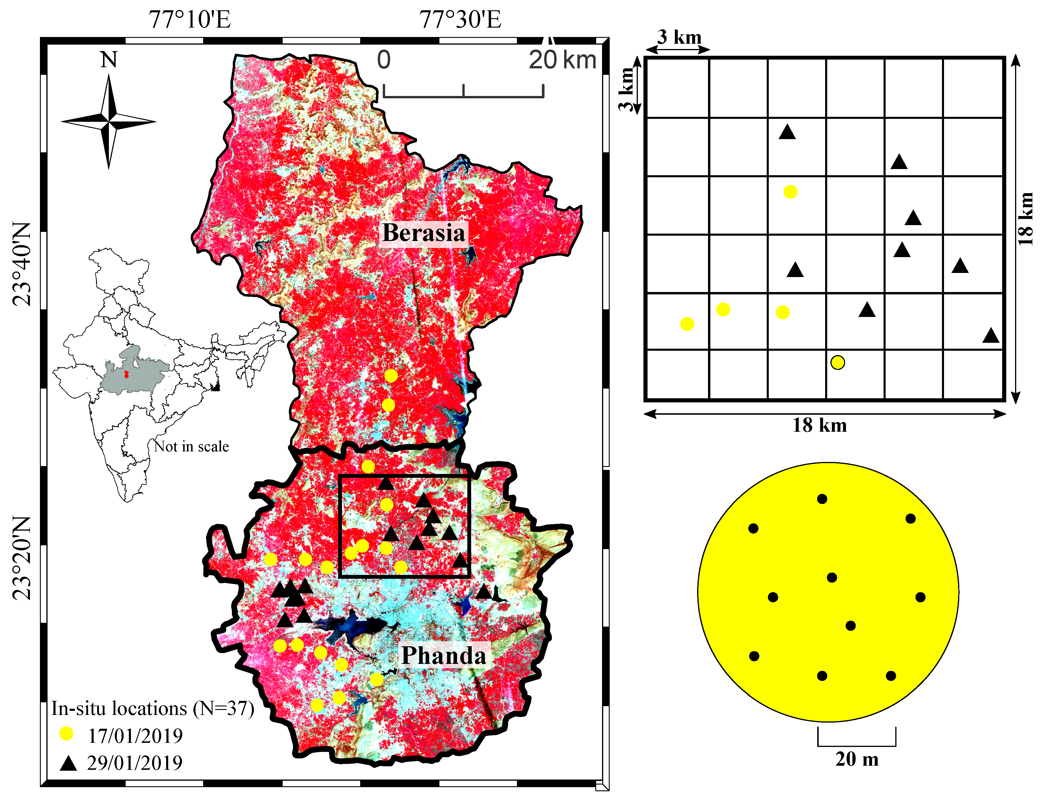
2. Study Area
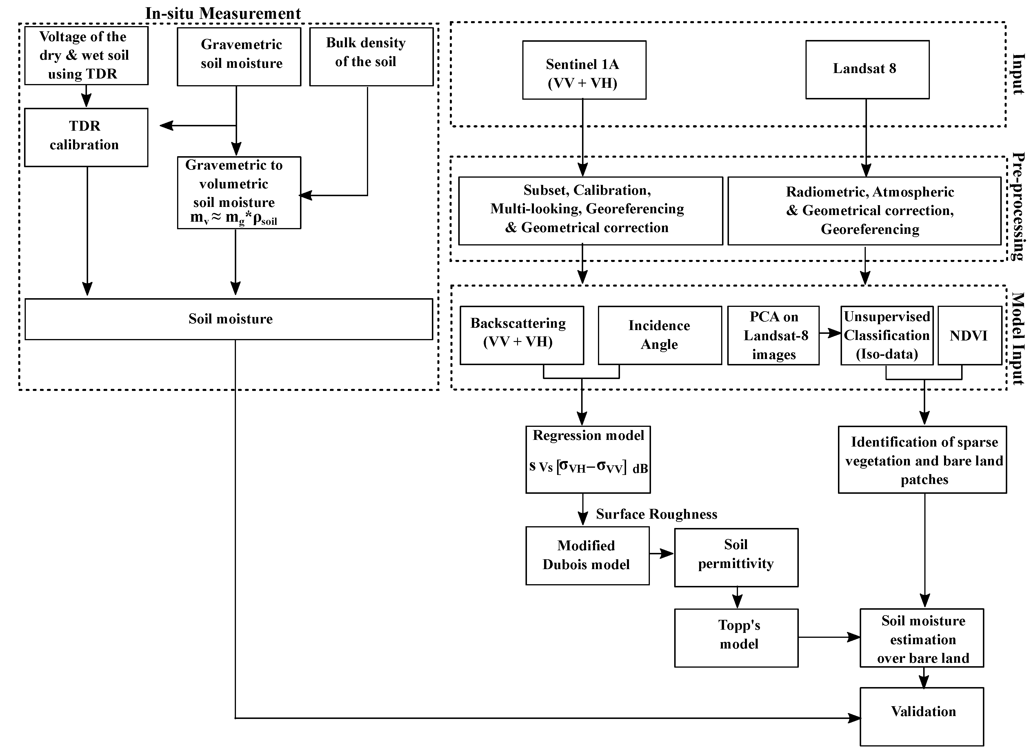
3. Material and Methods
3.1. Satellite Data
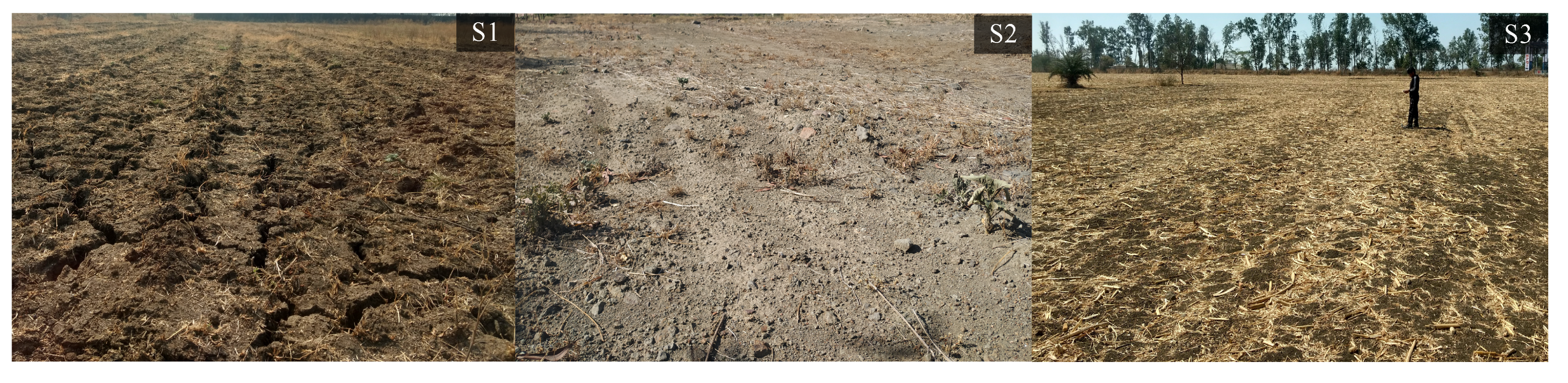
3.2. Field Measurement
3.3. Data Processing
3.3.1. Soil Samples
3.3.2. Satellite Images
3.4. Soil Moisture Modelling
3.4.1. Radar Backscattering Model
3.4.2. Estimation of Soil Moisture
4. Results
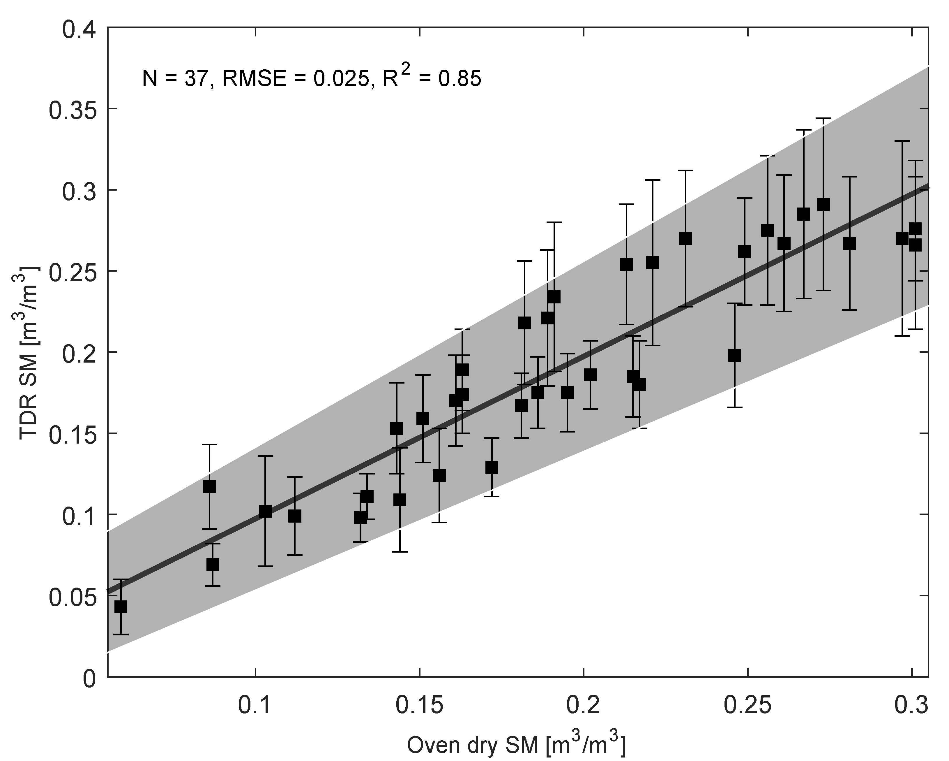
4.1. Performance of Calibrated Theta Probe
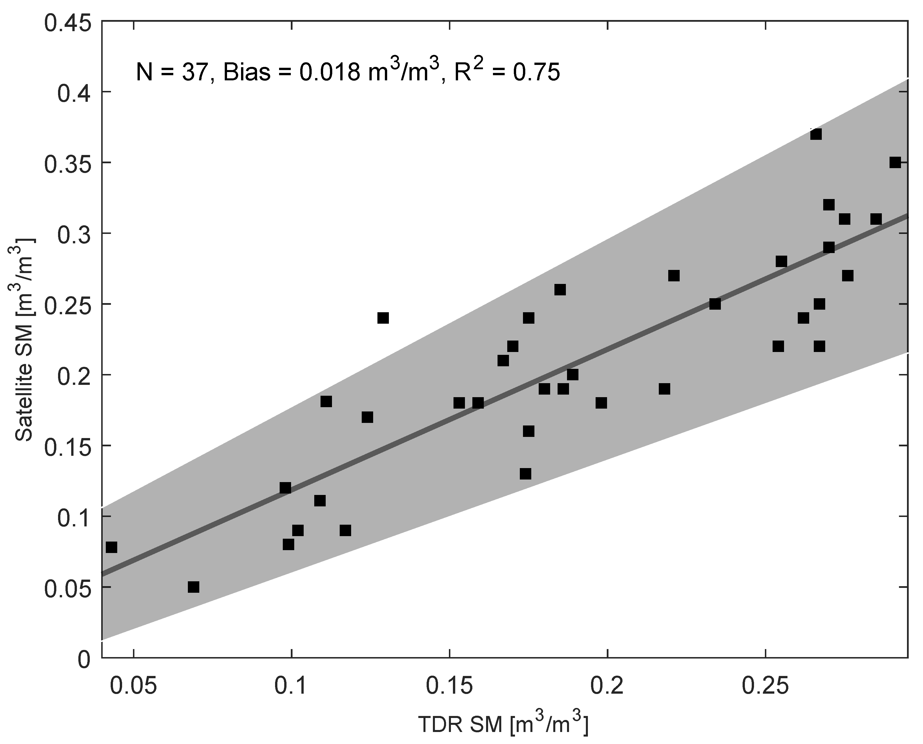
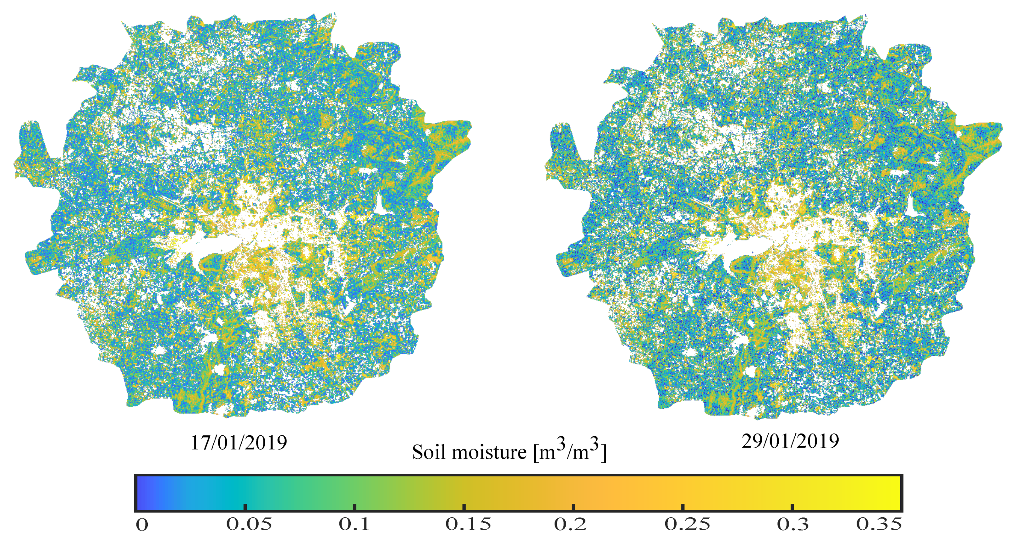
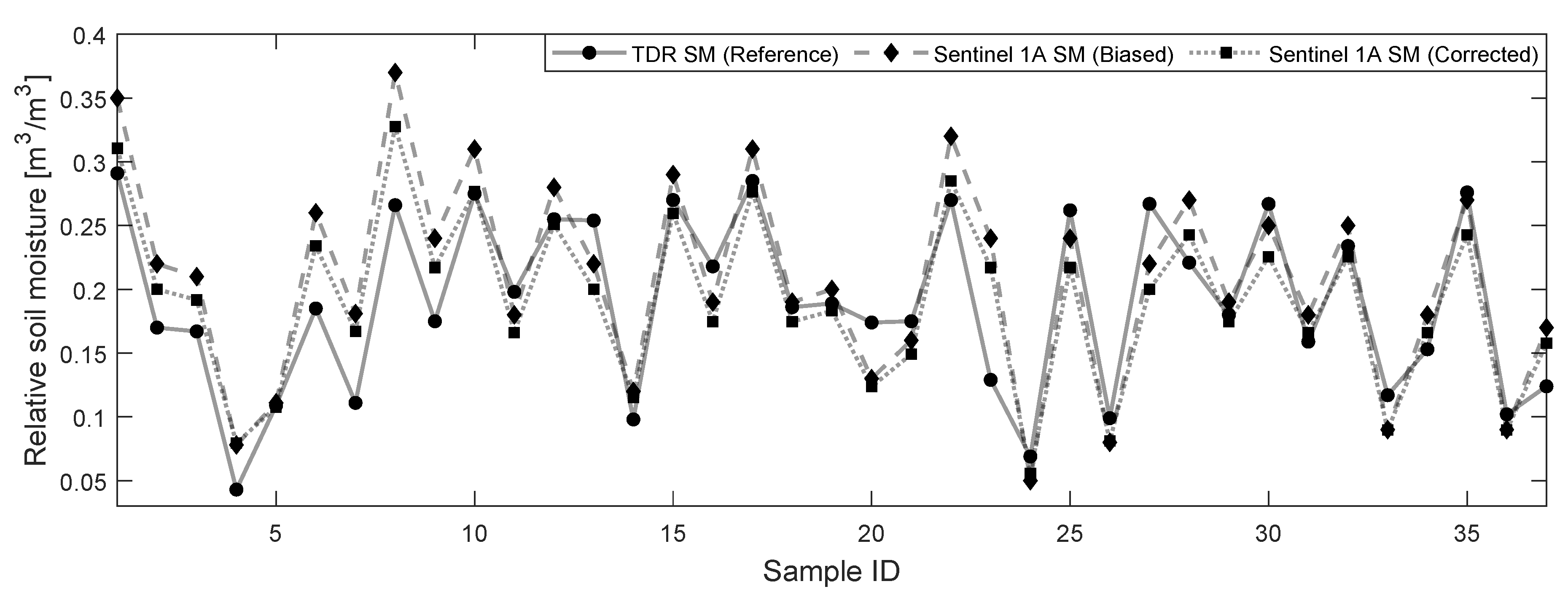
4.2. Soil Moisture from Sentinel-1A
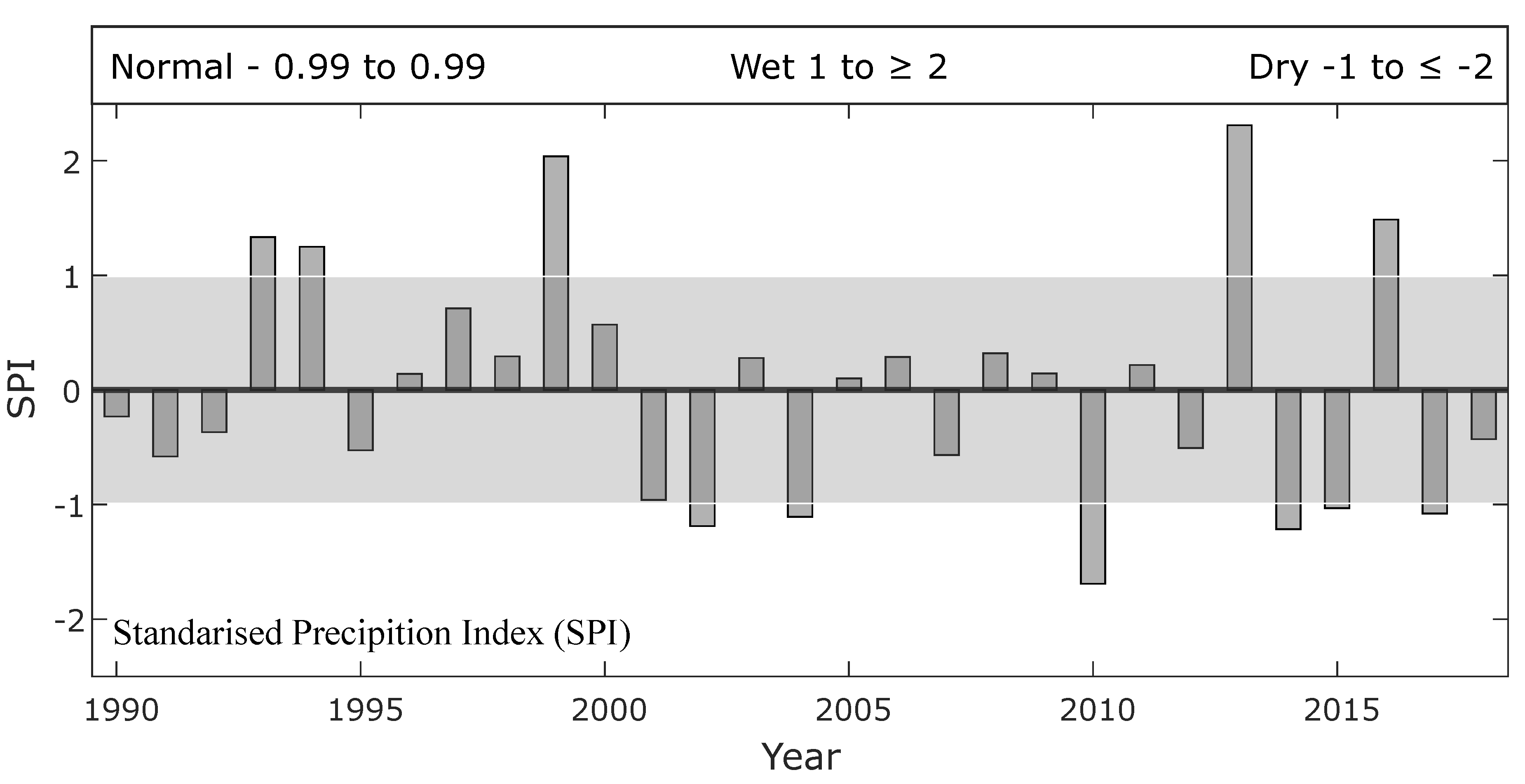
5. Discussion
6. Conclusions
Author Contributions
Funding
Acknowledgments
Conflicts of Interest
Appendix A


| Measuring Unit | Site 1 (S1) | Site 2 (S2) | Site 3 (S3) |
|---|---|---|---|
| (cm) | 563 | 563 | 563 |
| (gm) | 491 | 505 | 504 |
| (mV) | 342 | 333 | 350 |
| (gm) | 410 | 415 | 421 |
| (mV) | 101 | 72 | 90 |
| 1.6 | 1.5 | 1.6 | |
| 7.1 | 7.4 | 7.6 |
References
- Kite, G.; Pietroniro, A. Remote sensing applications in hydrological modelling. Hydrol. Sci. J. 1996, 41, 563–591. [Google Scholar] [CrossRef]
- Jackson, T.J. Measuring surface soil moisture using passive microwave remote sensing. Hydrol. Process. 1993, 7, 139–152. [Google Scholar] [CrossRef]
- Entekhabi, D. Retrieval of Soil Moisture Profile by Combined Remote Sensing and Modeling. 1993. Available online: https://trs.jpl.nasa.gov/handle/2014/34543 (accessed on 11 May 2020).
- Jackson, T.; Hawley, M.; O’neill, P. Preplanting soil moisture using passive microwave sensor. JAWRA J. Am. Water Resour. Assoc. 1987, 23, 11–19. [Google Scholar] [CrossRef]
- Martin, M.E.; Aber, J.D. High spectral resolution remote sensing of forest canopy lignin, nitrogen, and ecosystem processes. Ecol. Appl. 1997, 7, 431–443. [Google Scholar] [CrossRef]
- Sivapalan, M.; Takeuchi, K.; Franks, S.; Gupta, V.; Karambiri, H.; Lakshmi, V.; Liang, X.; McDonnell, J.; Mendiondo, E.; O’connell, P. IAHS Decade on Predictions in Ungauged Basins (PUB), 2003–2012: Shaping an exciting future for the hydrological sciences. Hydrol. Sci. J. 2003, 48, 857–880. [Google Scholar] [CrossRef] [Green Version]
- Field, C.B.; Randerson, J.T.; Malmström, C.M. Global net primary production: Combining ecology and remote sensing. Remote Sens. Environ. 1995, 51, 74–88. [Google Scholar] [CrossRef] [Green Version]
- Seneviratne, S.I.; Corti, T.; Davin, E.L.; Hirschi, M.; Jaeger, E.B.; Lehner, I.; Orlowsky, B.; Teuling, A.J. Investigating soil moisture–climate interactions in a changing climate: A review. Earth-Sci. Rev. 2010, 99, 125–161. [Google Scholar] [CrossRef]
- Kerr, J.T.; Ostrovsky, M. From space to species: Ecological applications for remote sensing. Trends Ecol. Evol. 2003, 18, 299–305. [Google Scholar] [CrossRef]
- Mulla, D.J. Twenty five years of remote sensing in precision agriculture: Key advances and remaining knowledge gaps. Biosyst. Eng. 2013, 114, 358–371. [Google Scholar] [CrossRef]
- Walker, J.P. Estimating Soil Moisture Profile Dynamics from Near-Surface Soil Moisture Measurements and Standard Meteorological Data. Ph.D. Thesis, University of Newcastle, Callaghan, Australia, 1999. [Google Scholar]
- Narvekar, P.S.; Entekhabi, D.; Kim, S.; Njoku, E.G. Soil Moisture Retrieval Using L-Band Radar Observations. IEEE Trans. Geosci. Remote Sens. 2015, 53, 3492–3506. [Google Scholar] [CrossRef]
- Ulaby, F.T. Microwave remote sensing active and passive. In Rader Remote Sensing and Surface Scattering and Emission Theory; NASA Technical Report; Kansas University: Lawrence, KS, USA, 1982; pp. 848–902. [Google Scholar]
- Altese, E.; Bolognani, O.; Mancini, M.; Troch, P.A. Retrieving soil moisture over bare soil from ERS 1 synthetic aperture radar data: Sensitivity analysis based on a theoretical surface scattering model and field data. Water Resour. Res. 1996, 32, 653–661. [Google Scholar] [CrossRef]
- Verhoest, N.E.; Lievens, H.; Wagner, W.; Álvarez-Mozos, J.; Moran, M.S.; Mattia, F. On the soil roughness parameterization problem in soil moisture retrieval of bare surfaces from synthetic aperture radar. Sensors 2008, 8, 4213–4248. [Google Scholar] [CrossRef] [Green Version]
- Barrett, B.W.; Dwyer, E.; Whelan, P. Soil moisture retrieval from active spaceborne microwave observations: An evaluation of current techniques. Remote Sens. 2009, 1, 210–242. [Google Scholar] [CrossRef] [Green Version]
- Oh, Y.; Sarabandi, K.; Ulaby, F.T. An empirical model and an inversion technique for radar scattering from bare soil surfaces. IEEE Trans. Geosci. Remote Sens. 1992, 30, 370–381. [Google Scholar] [CrossRef]
- Oh, Y.; Sarabandi, K.; Ulaby, F.T. An inversion algorithm for retrieving soil moisture and surface roughness from polarimetric radar observation. In Proceedings of the IEEE International Geoscience and Remote Sensing Symposium, Pasadena, CA, USA, 8–12 August 1994; Volume 3, pp. 1582–1584. [Google Scholar]
- Dubois, P.C.; Van Zyl, J.; Engman, T. Measuring soil moisture with imaging radars. IEEE Trans. Geosci. Remote Sens. 1995, 33, 915–926. [Google Scholar] [CrossRef] [Green Version]
- Oh, Y.; Sarabandi, K.; Ulaby, F.T. Semi-empirical model of the ensemble-averaged differential Mueller matrix for microwave backscattering from bare soil surfaces. IEEE Trans. Geosci. Remote Sens. 2002, 40, 1348–1355. [Google Scholar] [CrossRef] [Green Version]
- Oh, Y. Quantitative retrieval of soil moisture content and surface roughness from multipolarized radar observations of bare soil surfaces. IEEE Trans. Geosci. Remote Sens. 2004, 42, 596–601. [Google Scholar] [CrossRef]
- Attema, E.; Ulaby, F.T. Vegetation modeled as a water cloud. Radio Sci. 1978, 13, 357–364. [Google Scholar] [CrossRef]
- Fung, A.K.; Li, Z.; Chen, K.S. Backscattering from a randomly rough dielectric surface. IEEE Trans. Geosci. Remote Sens. 1992, 30, 356–369. [Google Scholar] [CrossRef]
- Fung, A.K.; Cheng, K.S. Microwave Scattering and Emission Models and Their Applications; Artech House Inc.: Boston, MA, USA, 1994. [Google Scholar]
- Baghdadi, N.; Cresson, R.; El Hajj, M.; Ludwig, R.; La Jeunesse, I. Soil parameters estimation over bare agriculture areas from C-band polarimetric SAR data using neural networks. Hydrol. Earth Syst. Sci. Discuss. 2012, 9, 2897–2933. [Google Scholar] [CrossRef] [Green Version]
- El Hajj, M.; Baghdadi, N.; Zribi, M.; Belaud, G.; Cheviron, B.; Courault, D.; Charron, F. Soil moisture retrieval over irrigated grassland using X-band SAR data. Remote Sens. Environ. 2016, 176, 202–218. [Google Scholar] [CrossRef] [Green Version]
- Dabrowska-Zielinska, K.; Musial, J.; Malinska, A.; Budzynska, M.; Gurdak, R.; Kiryla, W.; Bartold, M.; Grzybowski, P. Soil moisture in the Biebrza Wetlands retrieved from Sentinel-1 imagery. Remote Sens. 2018, 10, 1979. [Google Scholar] [CrossRef] [Green Version]
- Wagner, W.; Pathe, C.; Doubkova, M.; Sabel, D.; Bartsch, A.; Hasenauer, S.; Blöschl, G.; Scipal, K.; Martínez-Fernández, J.; Löw, A. Temporal stability of soil moisture and radar backscatter observed by the Advanced Synthetic Aperture Radar (ASAR). Sensors 2008, 8, 1174–1197. [Google Scholar] [CrossRef] [PubMed] [Green Version]
- Zribi, M.; Muddu, S.; Bousbih, S.; Al Bitar, A.; Tomer, S.K.; Baghdadi, N.; Bandyopadhyay, S. Analysis of L-band SAR data for soil moisture estimations over agricultural areas in the tropics. Remote Sens. 2019, 11, 1122. [Google Scholar] [CrossRef] [Green Version]
- Yang, L.; Feng, X.; Liu, F.; Liu, J.; Sun, X. Potential of soil moisture estimation using C-band polarimetric SAR data in arid regions. Int. J. Remote Sens. 2019, 40, 2138–2150. [Google Scholar] [CrossRef]
- El Hajj, M.; Baghdadi, N.; Zribi, M.; Bazzi, H. Synergic use of Sentinel-1 and Sentinel-2 images for operational soil moisture mapping at high spatial resolution over agricultural areas. Remote Sens. 2017, 9, 1292. [Google Scholar] [CrossRef] [Green Version]
- Bousbih, S.; Zribi, M.; El Hajj, M.; Baghdadi, N.; Lili-Chabaane, Z.; Gao, Q.; Fanise, P. Soil moisture and irrigation mapping in A semi-arid region, based on the synergetic use of Sentinel-1 and Sentinel-2 data. Remote Sens. 2018, 10, 1953. [Google Scholar] [CrossRef] [Green Version]
- Qiu, J.; Crow, W.T.; Wagner, W.; Zhao, T. Effect of vegetation index choice on soil moisture retrievals via the synergistic use of synthetic aperture radar and optical remote sensing. Int. J. Appl. Earth Obs. Geoinf. 2019, 80, 47–57. [Google Scholar] [CrossRef]
- Hachani, A.; Ouessar, M.; Paloscia, S.; Santi, E.; Pettinato, S. Soil moisture retrieval from Sentinel-1 acquisitions in an arid environment in Tunisia: Application of Artificial Neural Networks techniques. Int. J. Remote Sens. 2019, 40, 9159–9180. [Google Scholar] [CrossRef]
- Ezzahar, J.; Ouaadi, N.; Zribi, M.; Elfarkh, J.; Aouade, G.; Khabba, S.; Er-Raki, S.; Chehbouni, A.; Jarlan, L. Evaluation of Backscattering Models and Support Vector Machine for the Retrieval of Bare Soil Moisture from Sentinel-1 Data. Remote Sens. 2020, 12, 72. [Google Scholar] [CrossRef] [Green Version]
- Hosseini, M.; McNairn, H. Using multi-polarization C-and L-band synthetic aperture radar to estimate biomass and soil moisture of wheat fields. Int. J. Appl. Earth Obs. Geoinf. 2017, 58, 50–64. [Google Scholar] [CrossRef]
- Dave, R.; Kumar, G.; Kr. Pandey, D.; Khan, A.; Bhattacharya, B. Evaluation of modified Dubois model for estimating surface soil moisture using dual polarization RISAT-1 C-band SAR data. Geocarto Int. 2019, 1–11. [Google Scholar] [CrossRef]
- Alexakis, D.D.; Mexis, F.D.K.; Vozinaki, A.E.K.; Daliakopoulos, I.N.; Tsanis, I.K. Soil moisture content estimation based on Sentinel-1 and auxiliary earth observation products. A hydrological approach. Sensors 2017, 17, 1455. [Google Scholar] [CrossRef] [Green Version]
- Wagner, W.; Sabel, D.; Doubkova, M.; Bartsch, A.; Pathe, C. The potential of Sentinel-1 for monitoring soil moisture with a high spatial resolution at global scale. In Proceedings of the Earth Observation and Water Cycle Science, Frascati, Italy, 18–20 November 2009. [Google Scholar]
- Bauer-Marschallinger, B.; Freeman, V.; Cao, S.; Paulik, C.; Schaufler, S.; Stachl, T.; Modanesi, S.; Massari, C.; Ciabatta, L.; Brocca, L.; et al. Toward global soil moisture monitoring with Sentinel-1: Harnessing assets and overcoming obstacles. IEEE Trans. Geosci. Remote Sens. 2018, 57, 520–539. [Google Scholar] [CrossRef]
- Rao, S.S.; Das, S.; Nagaraju, M.; Venugopal, M.; Rajankar, P.; Laghate, P.; Reddy, M.S.; Joshi, A.; Sharma, J. Modified Dubois model for estimating soil moisture with dual polarized SAR data. J. Indian Soc. Remote Sens. 2013, 41, 865–872. [Google Scholar]
- Thanabalan, P.; Vidhya, R. A synergistic approach for soil moisture estimation using modified Dubois model with dual-polarized SAR and optical satellite data. Proc. SPIE 2016, 9877. [Google Scholar] [CrossRef]
- Mirsoleimani, H.R.; Sahebi, M.R.; Baghdadi, N.; El Hajj, M. Bare soil surface moisture retrieval from sentinel-1 SAR data based on the calibrated IEM and Dubois models using neural networks. Sensors 2019, 19, 3209. [Google Scholar] [CrossRef] [Green Version]
- NRSC. District and Category Wise Distribution of Land Use and Land Cover in Madhya Pradesh (2015-16). Available online: https://bhuvan-app1.nrsc.gov.in/2dresources/thematic/LULC503/MAP/MP.pdf (accessed on 25 May 2020).
- Ministry of Water Resources, Central Ground Water Board, North Central Region, Bhopal. District Ground Water Information Booklet. Available online: http://cgwb.gov.in/District_Profile/MP/Bhopal.pdf (accessed on 25 May 2020).
- Central Ground Water Board, Ministry of Water Resources, River Development and Ganga Rejuvenation, Government of India. Aquifer Mapping Report Phanda Block, Bhopal District, Madhya Pradesh. Available online: http://cgwb.gov.in/AQM/NAQUIM_REPORT/MP/PhandaBlockBhopal.pdf (accessed on 25 May 2020).
- Mishra, V.; Shah, R.; Garg, A. Climate Change in Madhya Pradesh: Indicators, Impacts and Adaptation; Indian Institute of Management Ahmadabad: Ahmedabad, India, 2016. [Google Scholar]
- Pai, D.; Sridhar, L.; Rajeevan, M.; Sreejith, O.; Satbhai, N.; Mukhopadhyay, B. Development of a new high spatial resolution (0.25 × 0.25) long period (1901–2010) daily gridded rainfall data set over India and its comparison with existing data sets over the region. Mausam 2014, 65, 1–18. [Google Scholar]
- Indian Meteorological Department. Rainfall Data. Available online: http://www.imdpune.gov.in/Clim_Pred_LRF_New/Grided_Data_Download.html (accessed on 25 May 2020).
- Hayes, M.J.; Svoboda, M.D.; Wiihite, D.A.; Vanyarkho, O.V. Monitoring the 1996 drought using the standardized precipitation index. Bull. Am. Meteorol. Soc. 1999, 80, 429–438. [Google Scholar] [CrossRef] [Green Version]
- Singh, A.; Meena, G.K.; Kumar, S.; Gaurav, K. Analysis of the effect of incidence angle and moisture content on the penetration depth of L-and S-band SAR signals into the ground surface. ISPRS Ann. Photogramm. Remote Sens. Spat. Inf. Sci. 2018, 4, 197–202. [Google Scholar] [CrossRef] [Green Version]
- Singh, A.; Meena, G.K.; Kumar, S.; Gaurav, K. Evaluation of the Penetration Depth of L-and S-Band (NISAR mission) Microwave SAR Signals into Ground. In Proceedings of the 2019 URSI Asia-Pacific Radio Science Conference (AP-RASC), New Delhi, India, 9–15 March 2019. [Google Scholar]
- Potin, P.; Rosich, B.; Grimont, P.; Miranda, N.; Shurmer, I.; O’Connell, A.; Torres, R.; Krassenburg, M. Sentinel-1 mission status. In Proceedings of the EUSAR 2016: 11th European Conference on Synthetic Aperture Radar, Hamburg, Germany, 6–9 June 2016; pp. 1–6. [Google Scholar]
- Filipponi, F. Sentinel-1 GRD Preprocessing Workflow. 3rd International Electronic Conference on Remote Sensing. Proceedings 2019, 18, 11. [Google Scholar] [CrossRef] [Green Version]
- Frison, P.L.; Fruneau, B.; Kmiha, S.; Soudani, K.; Dufrêne, E.; Le Toan, T.; Koleck, T.; Villard, L.; Mougin, E.; Rudant, J.P. Potential of Sentinel-1 data for monitoring temperate mixed forest phenology. Remote Sens. 2018, 10, 2049. [Google Scholar] [CrossRef] [Green Version]
- Gao, Q.; Zribi, M.; Escorihuela, M.J.; Baghdadi, N. Synergetic use of Sentinel-1 and Sentinel-2 data for soil moisture mapping at 100 m resolution. Sensors 2017, 17, 1966. [Google Scholar] [CrossRef] [Green Version]
- Martinis, S.; Plank, S.; Ćwik, K. The use of Sentinel-1 time-series data to improve flood monitoring in arid areas. Remote Sens. 2018, 10, 583. [Google Scholar] [CrossRef] [Green Version]
- Roy, D.P.; Wulder, M.A.; Loveland, T.R.; Woodcock, C.; Allen, R.G.; Anderson, M.C.; Helder, D.; Irons, J.R.; Johnson, D.M.; Kennedy, R.; et al. Landsat-8: Science and product vision for terrestrial global change research. Remote Sens. Environ. 2014, 145, 154–172. [Google Scholar] [CrossRef] [Green Version]
- Guo, M. Soil sampling and methods of analysis. J. Environ. Qual. 2009, 38, 375. [Google Scholar] [CrossRef]
- Gardner, C.M.; Robinson, D.A.; Blyth, K.; Cooper, J.D. Soil water content. In Soil and Environmental Analysis: Physical Methods; Smith, K.A., Mullins, C.E., Eds.; Marcel Dekker: New York, NY, USA, 2001; pp. 1–64. [Google Scholar]
- Reynolds, S. The gravimetric method of soil moisture determination Part I. A study of equipment, and methodological problems. J. Hydrol. 1970, 11, 258–273. [Google Scholar] [CrossRef]
- Srivastava, H.; Patel, P.; Navalgund, R.; Sharma, Y. Retrieval of surface roughness using multi-polarized Envisat-1 ASAR data. Geocarto Int. 2008, 23, 67–77. [Google Scholar] [CrossRef]
- Topp, G.C.; Davis, J.; Annan, A.P. Electromagnetic determination of soil water content: Measurements in coaxial transmission lines. Water Resour. Res. 1980, 16, 574–582. [Google Scholar] [CrossRef] [Green Version]
- Song, K.; Zhou, X.; Fan, Y. Empirically adopted IEM for retrieval of soil moisture from radar backscattering coefficients. IEEE Trans. Geosci. Remote Sens. 2009, 47, 1662–1672. [Google Scholar] [CrossRef]
- Talone, M.; Camps, A.; Monerris, A.; Vall-llossera, M.; Ferrazzoli, P.; Piles, M. Surface topography and mixed-pixel effects on the simulated L-band brightness temperatures. IEEE Trans. Geosci. Remote Sens. 2007, 45, 1996–2003. [Google Scholar] [CrossRef]
- Zhang, T.; Zhang, L.; Jiang, L.; Zhao, S.; Zhao, T.; Li, Y. Effects of spatial distribution of soil parameters on soil moisture retrieval from passive microwave remote sensing. Sci. China Earth Sci. 2012, 55, 1313–1322. [Google Scholar] [CrossRef]
- Lee, J.H.; Zhao, C.; Kerr, Y. Stochastic bias correction and uncertainty estimation of satellite-retrieved soil moisture products. Remote Sens. 2017, 9, 847. [Google Scholar] [CrossRef] [Green Version]
- Michelangeli, P.A.; Vrac, M.; Loukos, H. Probabilistic downscaling approaches: Application to wind cumulative distribution functions. Geophys. Res. Lett. 2009, 36, 1–6. [Google Scholar] [CrossRef]
- Reichle, R.H. Data assimilation methods in the Earth sciences. Adv. Water Resour. 2008, 31, 1411–1418. [Google Scholar] [CrossRef]
- Reichle, R.H.; Koster, R.D. Bias reduction in short records of satellite soil moisture. Geophys. Res. Lett. 2004, 31, 1–4. [Google Scholar] [CrossRef] [Green Version]
- Draper, C.; Mahfouf, J.F.; Walker, J.P. An EKF assimilation of AMSR-E soil moisture into the ISBA land surface scheme. J. Geophys. Res. Atmos. 2009, 114, 1–13. [Google Scholar] [CrossRef] [Green Version]
- Hosseini, R.; Newlands, N.K.; Dean, C.B.; Takemura, A. Statistical modeling of soil moisture, integrating satellite remote-sensing (SAR) and ground-based data. Remote Sens. 2015, 7, 2752–2780. [Google Scholar] [CrossRef] [Green Version]
- Kumar, S.; Peters-Lidard, C.; Santanello, J.; Reichle, R.; Draper, C.; Koster, R.; Nearing, G.; Jasinski, M. Evaluating the utility of satellite soil moisture retrievals over irrigated areas and the ability of land data assimilation methods to correct for unmodeled processes. Hydrol. Earth Syst. Sci. 2015, 19, 4463–4478. [Google Scholar] [CrossRef] [Green Version]
- Leander, R.; Buishand, T.A. Resampling of regional climate model output for the simulation of extreme river flows. J. Hydrol. 2007, 332, 487–496. [Google Scholar] [CrossRef]
- Schmidli, J.; Frei, C.; Vidale, P.L. Downscaling from GCM precipitation: A benchmark for dynamical and statistical downscaling methods. Int. J. Climatol. 2006, 26, 679–689. [Google Scholar] [CrossRef]
- Lenderink, G.; Buishand, A.; Deursen, W.V. Estimates of future discharges of the river Rhine using two scenario methodologies: Direct versus delta approach. Hydrol. Earth Syst. Sci. 2007, 11, 1145–1159. [Google Scholar] [CrossRef]
- Panofsky, H.A.; Brier, G.W. Some Applications of Statistics to Meteorology; Pennsylvania State University: Pennsylvania, PA, USA, 1958. [Google Scholar]
- He, B.; Xing, M.; Bai, X. A synergistic methodology for soil moisture estimation in an alpine prairie using radar and optical satellite data. Remote Sens. 2014, 6, 10966–10985. [Google Scholar] [CrossRef] [Green Version]
- Bindlish, R.; Barros, A.P. Parameterization of vegetation backscatter in radar-based, soil moisture estimation. Remote Sens. Environ. 2001, 76, 130–137. [Google Scholar] [CrossRef]
- Gherboudj, I.; Magagi, R.; Berg, A.A.; Toth, B. Soil moisture retrieval over agricultural fields from multi-polarized and multi-angular RADARSAT-2 SAR data. Remote Sens. Environ. 2011, 115, 33–43. [Google Scholar] [CrossRef]
- Du, J.; Shi, J.; Sun, R. The development of HJ SAR soil moisture retrieval algorithm. Int. J. Remote Sens. 2010, 31, 3691–3705. [Google Scholar] [CrossRef]
- Lievens, H.; Verhoest, N.E. On the retrieval of soil moisture in wheat fields from L-band SAR based on water cloud modeling, the IEM, and effective roughness parameters. IEEE Geosci. Remote Sens. Lett. 2011, 8, 740–744. [Google Scholar] [CrossRef]
- De Roo, R.D.; Du, Y.; Ulaby, F.T.; Dobson, M.C. A semi-empirical backscattering model at L-band and C-band for a soybean canopy with soil moisture inversion. IEEE Trans. Geosci. Remote Sens. 2001, 39, 864–872. [Google Scholar] [CrossRef]


| Sentinel-1A | ||||
|---|---|---|---|---|
| Date | Polarisations | Incidence angle () | Pixel size (m ) | Direction |
| 17/01/2019 | VH + VV | 38.4 | 10 × 10 | NE |
| 29/01/2019 | VH + VV | 38.5 | 10 × 10 | NE |
| Landsat 8 | ||||
| Row/Path | Band | Wavelength () | Resolution (m) | |
| 15/01/2019 | 44/145 | 4, 5 | 0.64–0.67, 0.85–0.88 | 30 |
| 22/01/2019 | 43/146 | 4, 5 | 0.64–0.67, 0.85–0.88 | 30 |
| Date | Site ID | Latitute | Longitude | Elevation (msl) | Land Use | Sampling Depth (cm) | Vegetation Height (cm) | (m/m) (TDR) |
|---|---|---|---|---|---|---|---|---|
| 17-01-2019 | 1 | 23.22913 | 77.26613 | 516 | Agriculture land (Chickpeas) | 5 | 10–15 | 0.291 ± 0.053 |
| 17-01-2019 | 2 | 23.22978 | 77.28679 | 517 | Agriculture land (Chickpeas) | 5 | 15–20 | 0.170 ± 0.028 |
| 17-01-2019 | 3 | 23.22081 | 77.31552 | 515 | Agriculture land (Chickpeas) | 5 | 0–5 | 0.167 ± 0.020 |
| 17-01-2019 | 4 | 23.20669 | 77.34076 | 538 | Barren land | 5 | 0 | 0.043 ± 0.017 |
| 17-01-2019 | 5 | 23.18931 | 77.38358 | 507 | Barren land | 5 | 0 | 0.109 ± 0.032 |
| 17-01-2019 | 6 | 23.16962 | 77.33730 | 532 | Agriculture land (Mustard) | 5 | 20–30 | 0.185 ± 0.025 |
| 17-01-2019 | 7 | 23.16144 | 77.31003 | 546 | Barren land | 5 | 0 | 0.111 ± 0.014 |
| 17-01-2019 | 8 | 23.31624 | 77.41531 | 495 | Agriculture land (Wheat) | 5 | 15–20 | 0.266 ± 0.052 |
| 17-01-2019 | 9 | 23.33788 | 77.39777 | 497 | Agriculture land (Wheat) | 5 | 30–35 | 0.175 ± 0.022 |
| 17-01-2019 | 10 | 23.33280 | 77.35484 | 494 | Agriculture land (Coriander) | 5 | 10–15 | 0.275 ± 0.046 |
| 17-01-2019 | 11 | 23.31749 | 77.32511 | 503 | Agriculture land (Mixed) | 5 | 20–30 | 0.198 ± 0.032 |
| 17-01-2019 | 12 | 23.32754 | 77.25596 | 529 | Agriculture land (Wheat) | 5 | 20–30 | 0.255 ± 0.051 |
| 17-01-2019 | 13 | 23.32683 | 77.29851 | 510 | Agriculture land (Chickpeas) | 5 | 10–15 | 0.254 ± 0.037 |
| 17-01-2019 | 14 | 23.34099 | 77.36872 | 502 | Agriculture land (Wheat) | 5 | 30–40 | 0.098 ± 0.015 |
| 17-01-2019 | 15 | 23.38717 | 77.39961 | 488 | Agriculture land (Daikon) | 5 | 0 | 0.270 ± 0.042 |
| 17-01-2019 | 16 | 23.43098 | 77.37777 | 487 | Agriculture land (Chickpeas) | 5 | 15–20 | 0.218 ± 0.038 |
| 17-01-2019 | 17 | 23.50044 | 77.40357 | 476 | Agriculture land (Wheat) | 5 | 20–25 | 0.285 ± 0.052 |
| 17-01-2019 | 18 | 23.53360 | 77.40742 | 478 | Agriculture land (Chickpeas) | 5 | 10-15 | 0.186 ± 0.021 |
| 29-01-2019 | 19 | 23.41329 | 77.39910 | 484 | Agriculture land (Wheat) | 5 | 30–40 | 0.189 ± 0.025 |
| 29-01-2019 | 20 | 23.35487 | 77.40400 | 483 | Agriculture land (Wheat) | 5 | 40–50 | 0.174 ± 0.024 |
| 29-01-2019 | 21 | 23.34471 | 77.43551 | 490 | Agriculture land (Wheat) | 5 | 20–25 | 0.175 ± 0.024 |
| 29-01-2019 | 22 | 23.35516 | 77.47569 | 512 | Agriculture land (Wheat) | 5 | 10–15 | 0.270 ± 0.060 |
| 29-01-2019 | 23 | 23.37469 | 77.45610 | 492 | Agriculture land (Wheat) | 5 | 40–50 | 0.129 ± 0.018 |
| 29-01-2019 | 24 | 23.39272 | 77.44480 | 478 | Agriculture land (Wheat) | 5 | 20–25 | 0.069 ± 0.013 |
| 29-01-2019 | 25 | 23.36028 | 77.45131 | 501 | Agriculture land (Mixed) | 5 | 10–15 | 0.262 ± 0.033 |
| 29-01-2019 | 26 | 23.32369 | 77.48873 | 518 | Agriculture land (Wheat) | 5 | 30–40 | 0.099 ± 0.024 |
| 29-01-2019 | 27 | 23.28805 | 77.51691 | 491 | Agriculture land (Chickpeas) | 5 | 15–20 | 0.267 ± 0.041 |
| 29-01-2019 | 28 | 23.29685 | 77.27975 | 516 | Barren land | 5 | 0 | 0.221 ± 0.042 |
| 29-01-2019 | 29 | 23.29730 | 77.99768 | 519 | Agriculture land (Chickpeas) | 5 | 20–25 | 0.180 ± 0.027 |
| 29-01-2019 | 30 | 23.29316 | 77.26544 | 528 | Agriculture land (Wheat) | 5 | 15–20 | 0.267 ± 0.042 |
| 29-01-2019 | 31 | 23.29380 | 77.28096 | 520 | Agriculture land (Wheat) | 5 | 10–15 | 0.159 ± 0.027 |
| 29-01-2019 | 32 | 23.28579 | 77.28620 | 523 | Agriculture land (Mixed) | 5 | 5–10 | 0.234 ± 0.046 |
| 29-01-2019 | 33 | 23.28255 | 77.28209 | 519 | Agriculture land (Wheat) | 5 | 40–50 | 0.117 ± 0.026 |
| 29-01-2019 | 34 | 23.28405 | 77.28794 | 520 | Agriculture land (Chickpeas) | 5 | 10–15 | 0.153 ± 0.028 |
| 29-01-2019 | 35 | 23.29396 | 77.26690 | 526 | Agriculture land (Wheat) | 5 | 40–50 | 0.276 ± 0.032 |
| 29-01-2019 | 36 | 23.25948 | 77.27253 | 511 | Barren land | 5 | 0 | 0.102 ± 0.034 |
| 29-01-2019 | 37 | 23.26410 | 77.29583 | 515 | Agriculture land (Chickpeas) | 5 | 10–15 | 0.124 ± 0.029 |
© 2020 by the authors. Licensee MDPI, Basel, Switzerland. This article is an open access article distributed under the terms and conditions of the Creative Commons Attribution (CC BY) license (http://creativecommons.org/licenses/by/4.0/).
Share and Cite
Singh, A.; Gaurav, K.; Meena, G.K.; Kumar, S. Estimation of Soil Moisture Applying Modified Dubois Model to Sentinel-1; A Regional Study from Central India. Remote Sens. 2020, 12, 2266. https://doi.org/10.3390/rs12142266
Singh A, Gaurav K, Meena GK, Kumar S. Estimation of Soil Moisture Applying Modified Dubois Model to Sentinel-1; A Regional Study from Central India. Remote Sensing. 2020; 12(14):2266. https://doi.org/10.3390/rs12142266
Chicago/Turabian StyleSingh, Abhilash, Kumar Gaurav, Ganesh Kumar Meena, and Shashi Kumar. 2020. "Estimation of Soil Moisture Applying Modified Dubois Model to Sentinel-1; A Regional Study from Central India" Remote Sensing 12, no. 14: 2266. https://doi.org/10.3390/rs12142266
APA StyleSingh, A., Gaurav, K., Meena, G. K., & Kumar, S. (2020). Estimation of Soil Moisture Applying Modified Dubois Model to Sentinel-1; A Regional Study from Central India. Remote Sensing, 12(14), 2266. https://doi.org/10.3390/rs12142266