Characterizing the Spatial Variations of Forest Sunlit and Shaded Components Using Discrete Aerial Lidar


 and
and
Abstract
:
1. Introduction
2. Materials and Methods
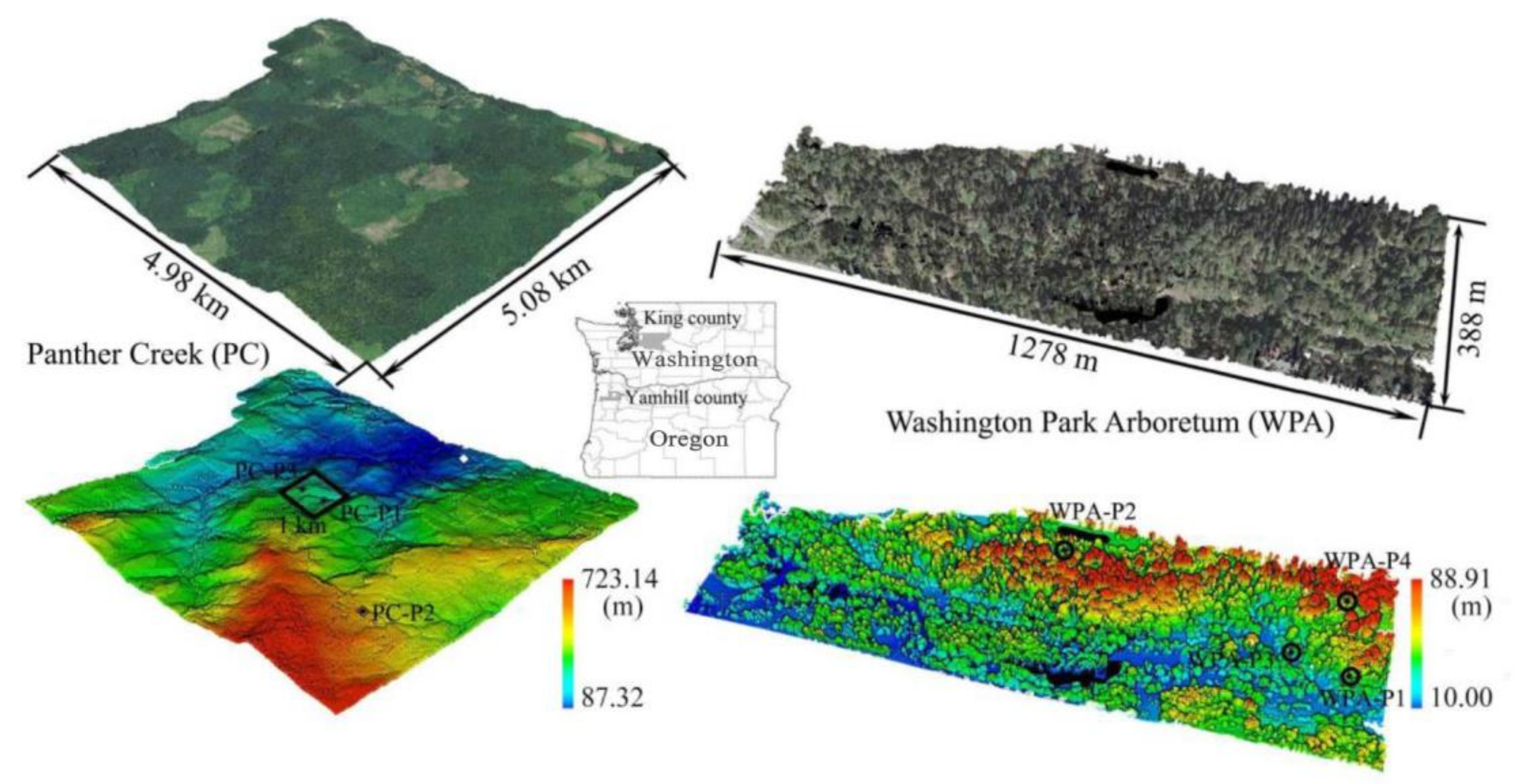
2.1. Study Sites
2.2. Datasets
2.2.1. Field Data
2.2.2. Aerial Laser Scanning (ALS) Data
2.2.3. Hyperspectral Imagery Data
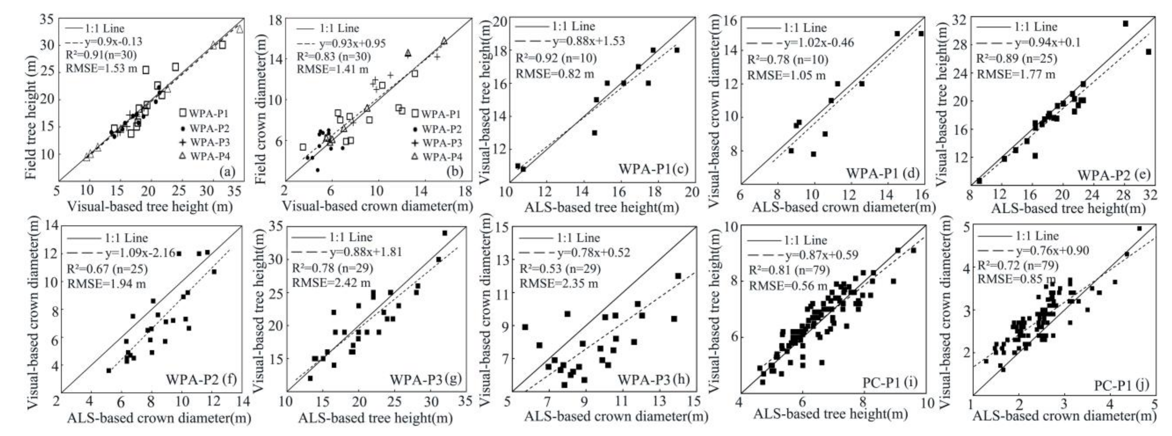
2.2.4. Visual-Based Validation Data
2.2.5. Modeled ALS Data
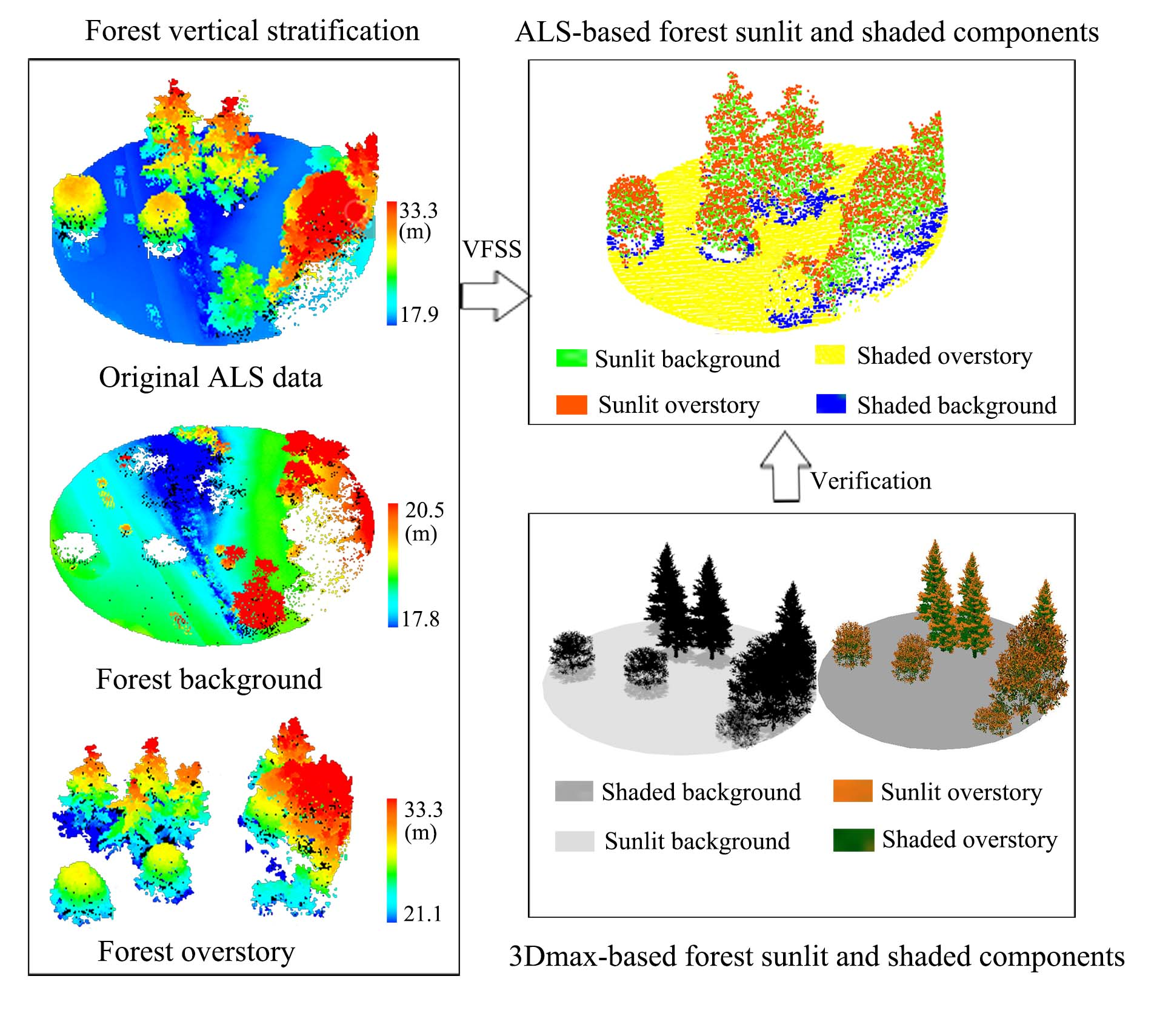
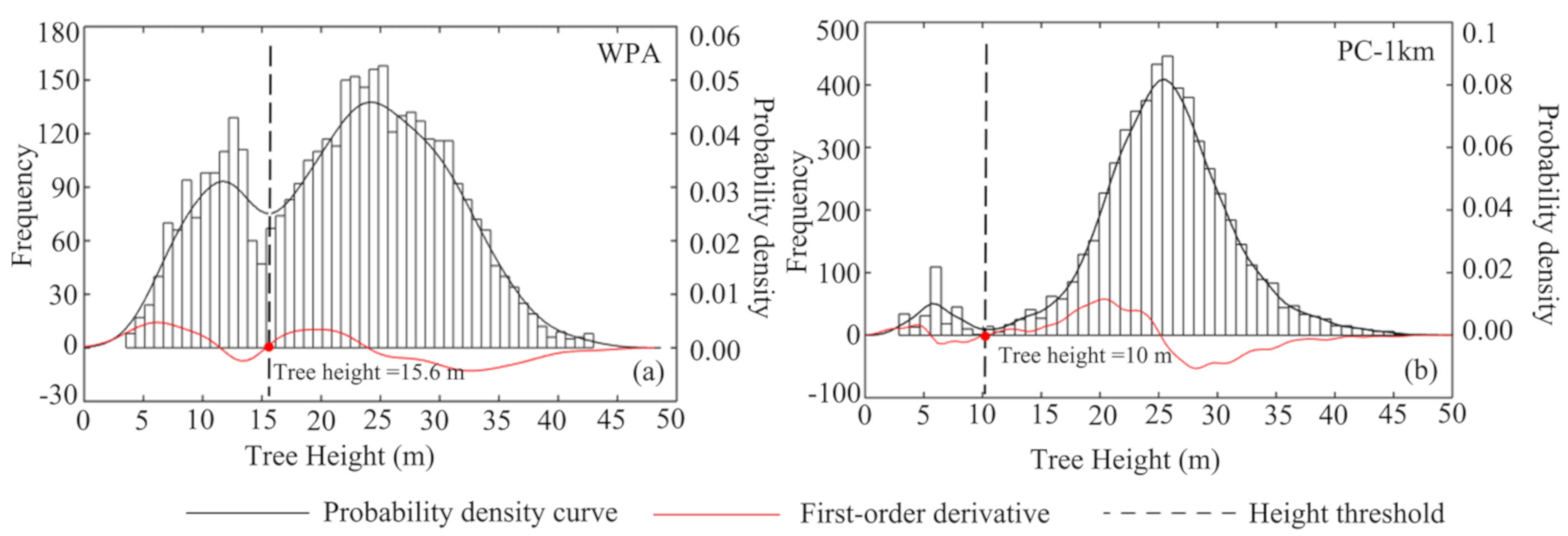
2.3. Forest Vertical Stratification
2.4. Voxel-Based Forest Sunlit and Shaded (VFSS) Components’ Estimation
2.5. Validation of the Four Forest Components
2.6. Validation Directional Forest Canopy Reflectance Estimation
2.7. Sensitivity Analysis
3. Results
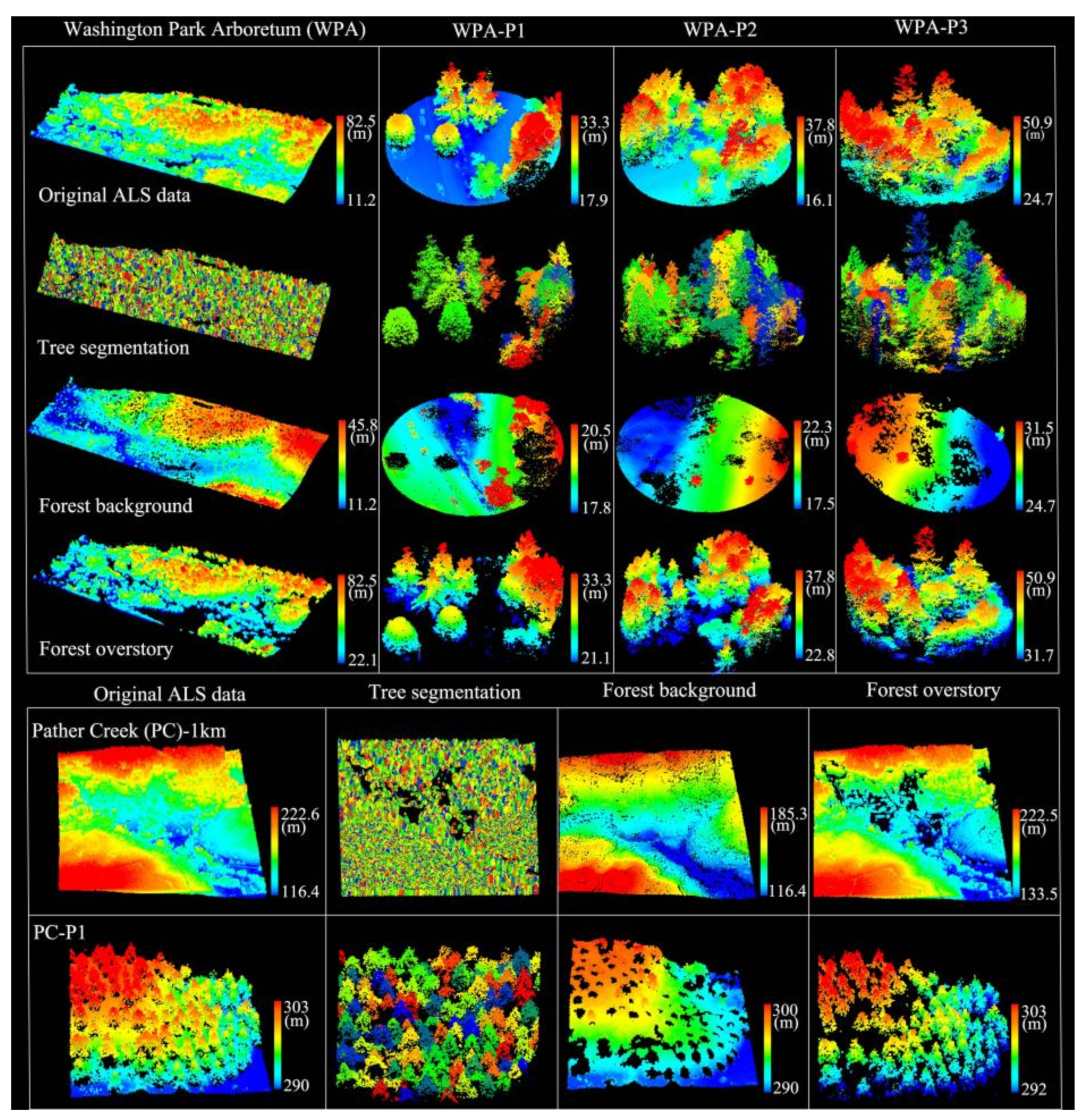
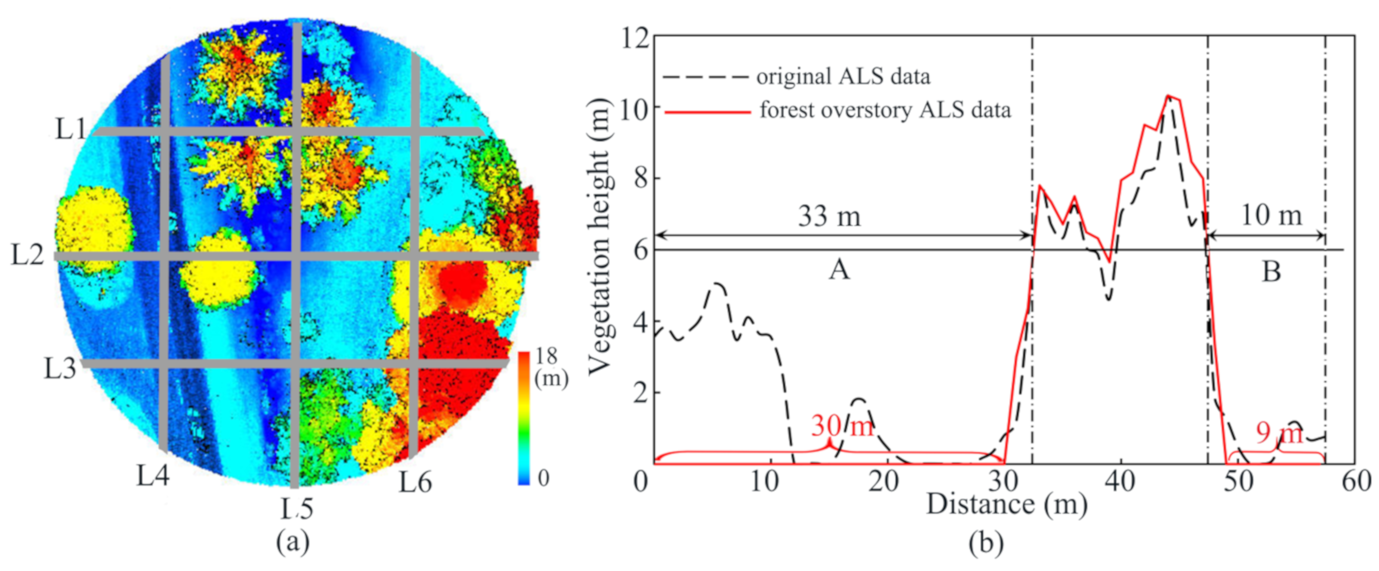
3.1. Forest Vertical Stratification
3.1.1. Tree Crown Segmentation
3.1.2. Separation of Overstory and Forest Background
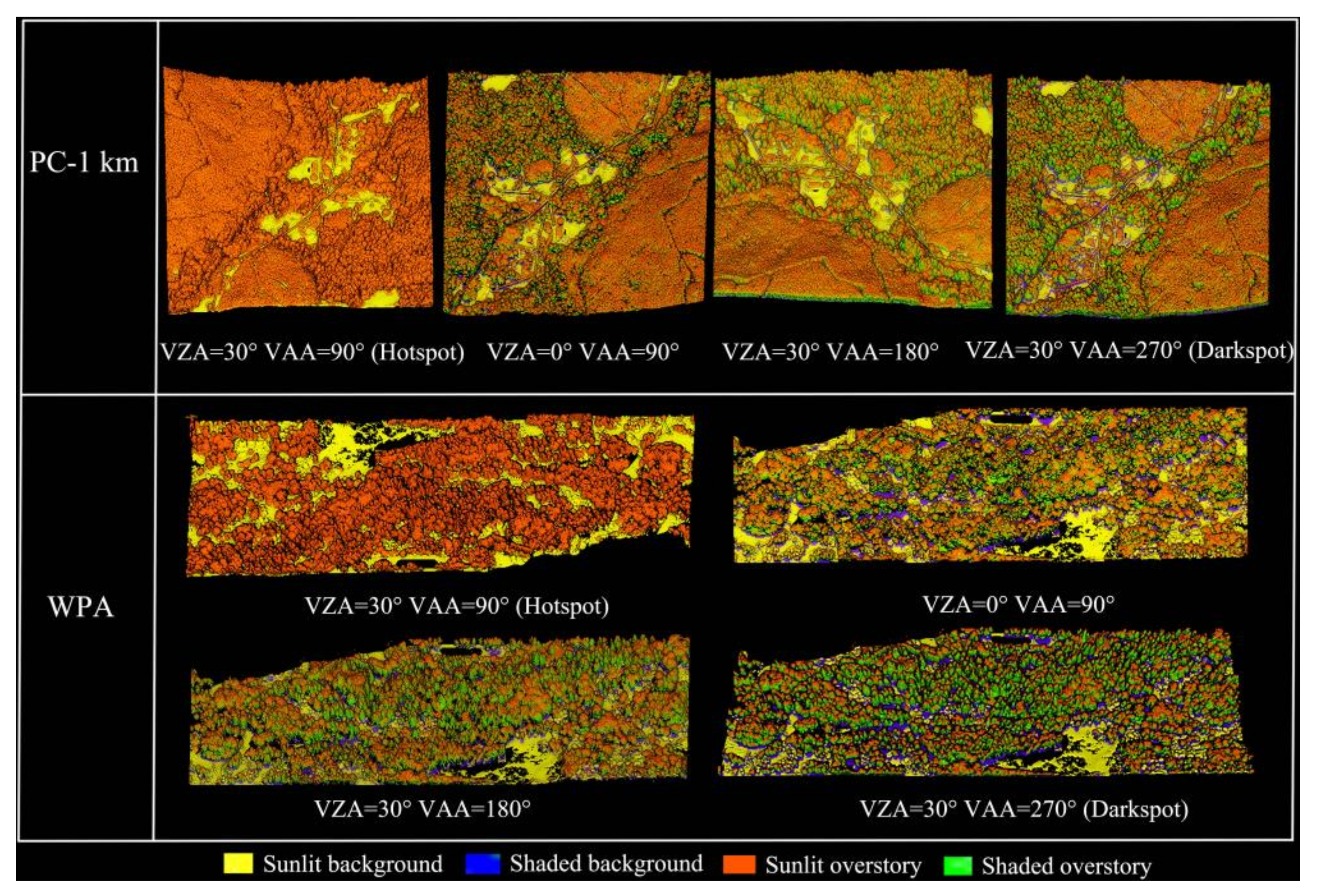
3.2. ALS-Based Sunlit and Shaded Forest Components
3.2.1. Landscape Scale
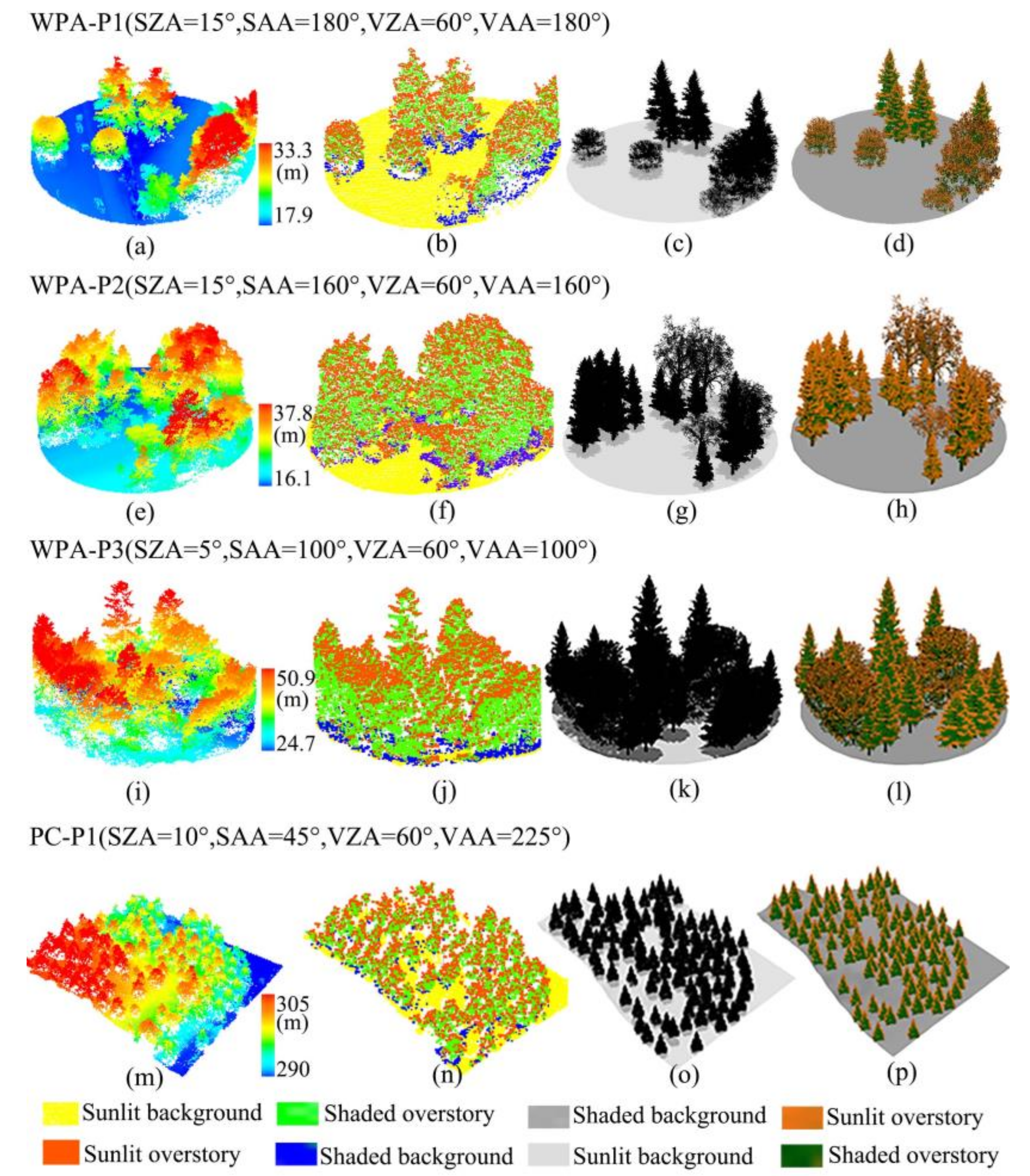
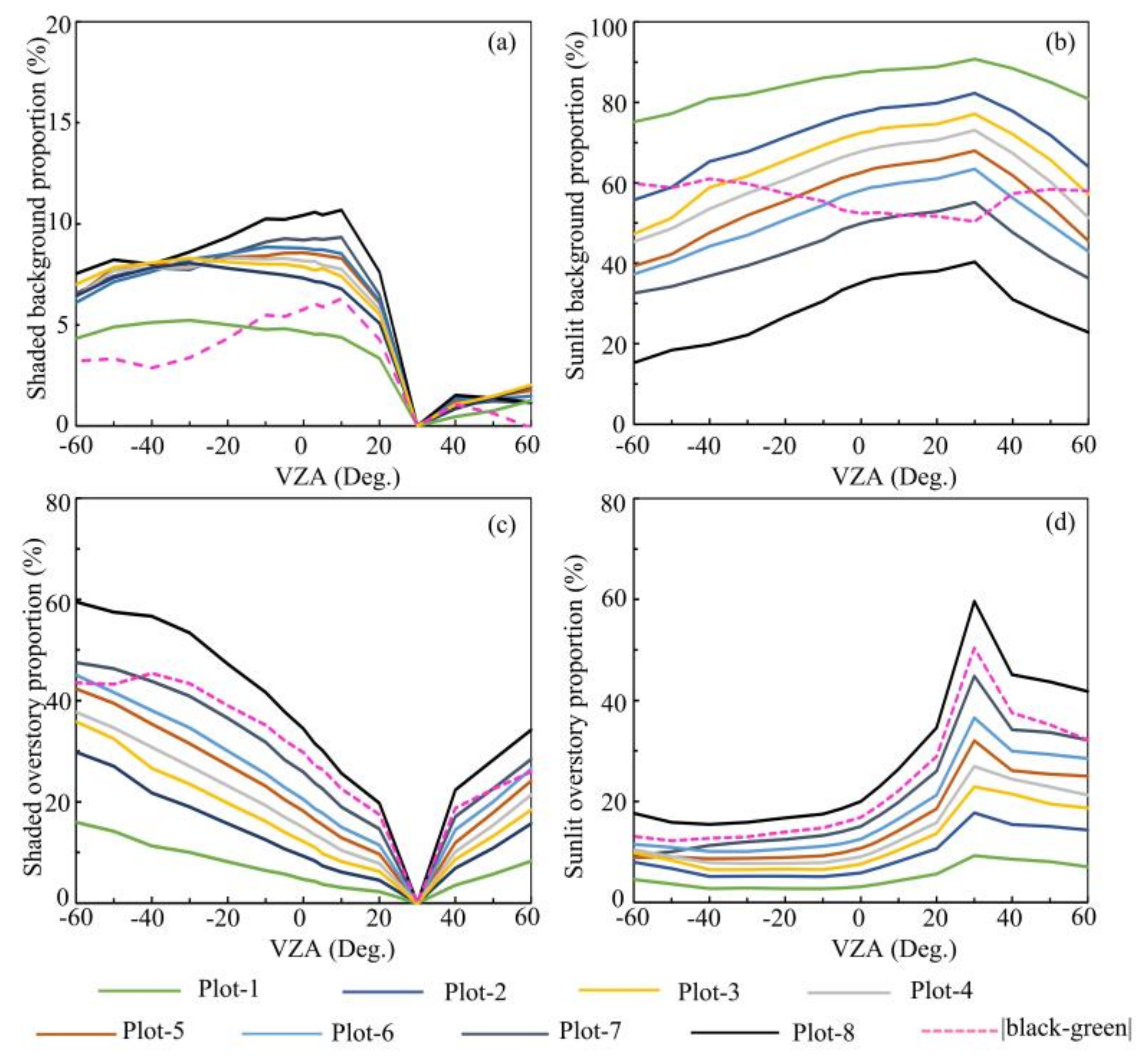
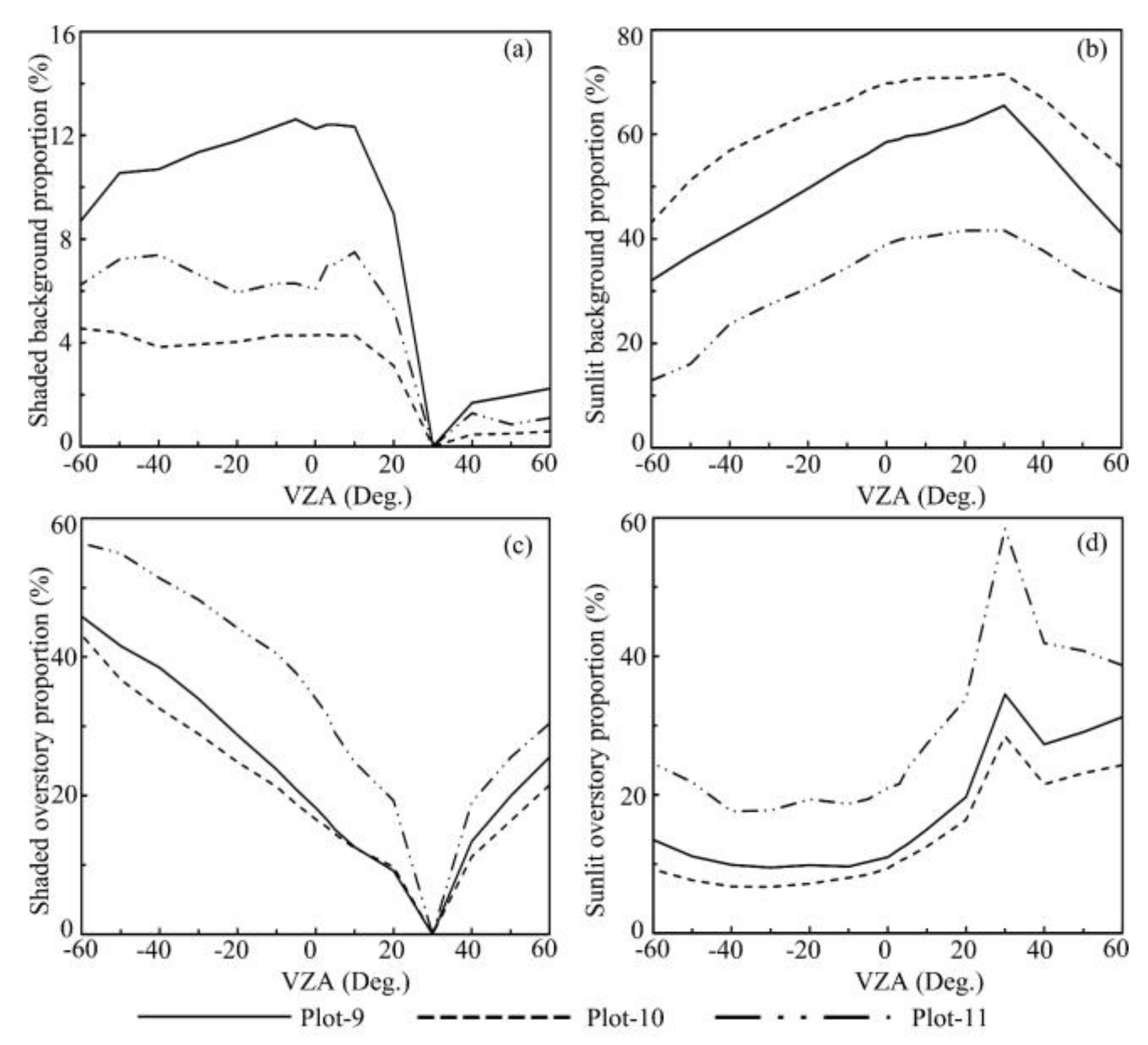
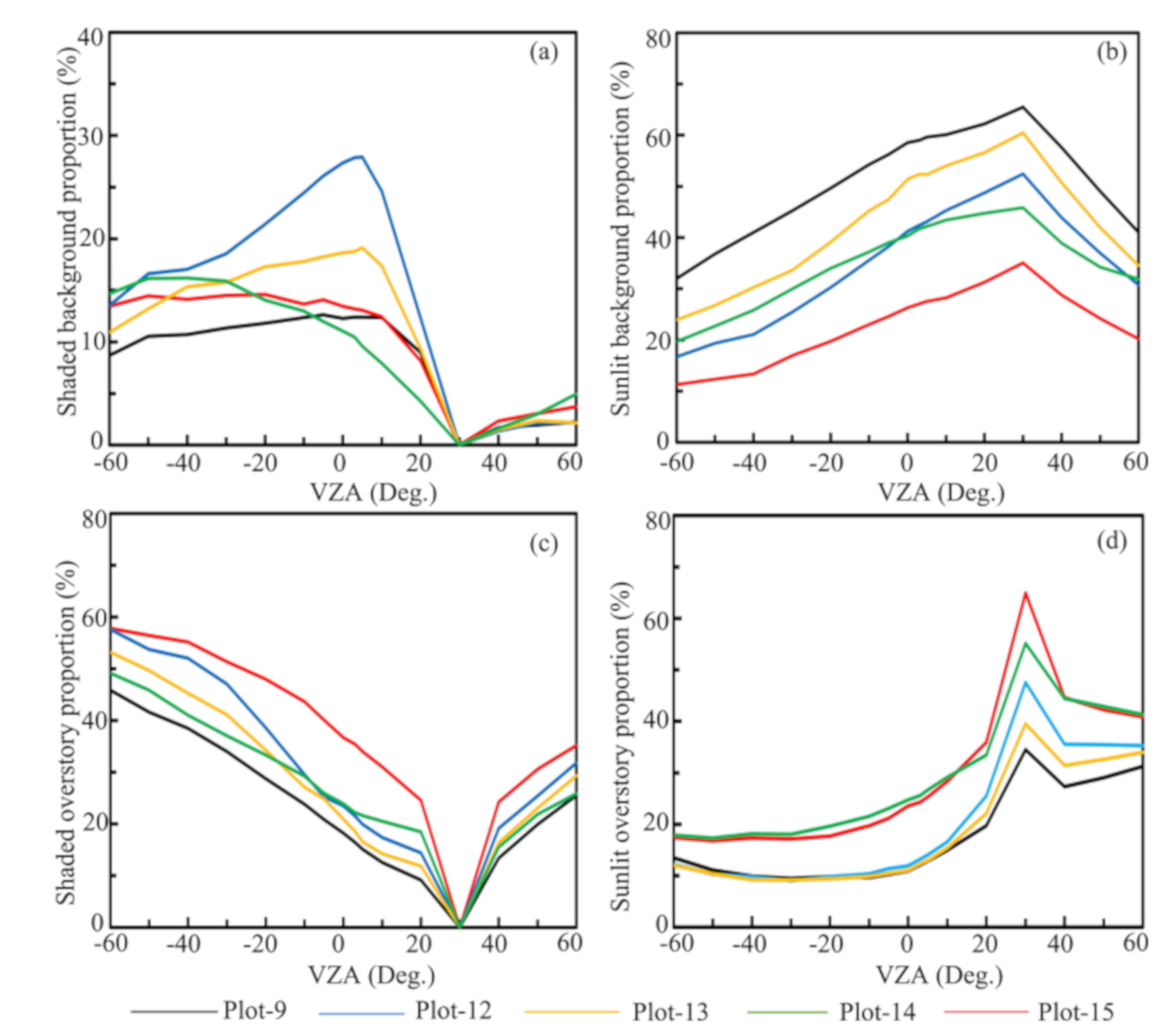
3.2.2. Plot Scale
3.3. Directional Forest Canopy Reflectance
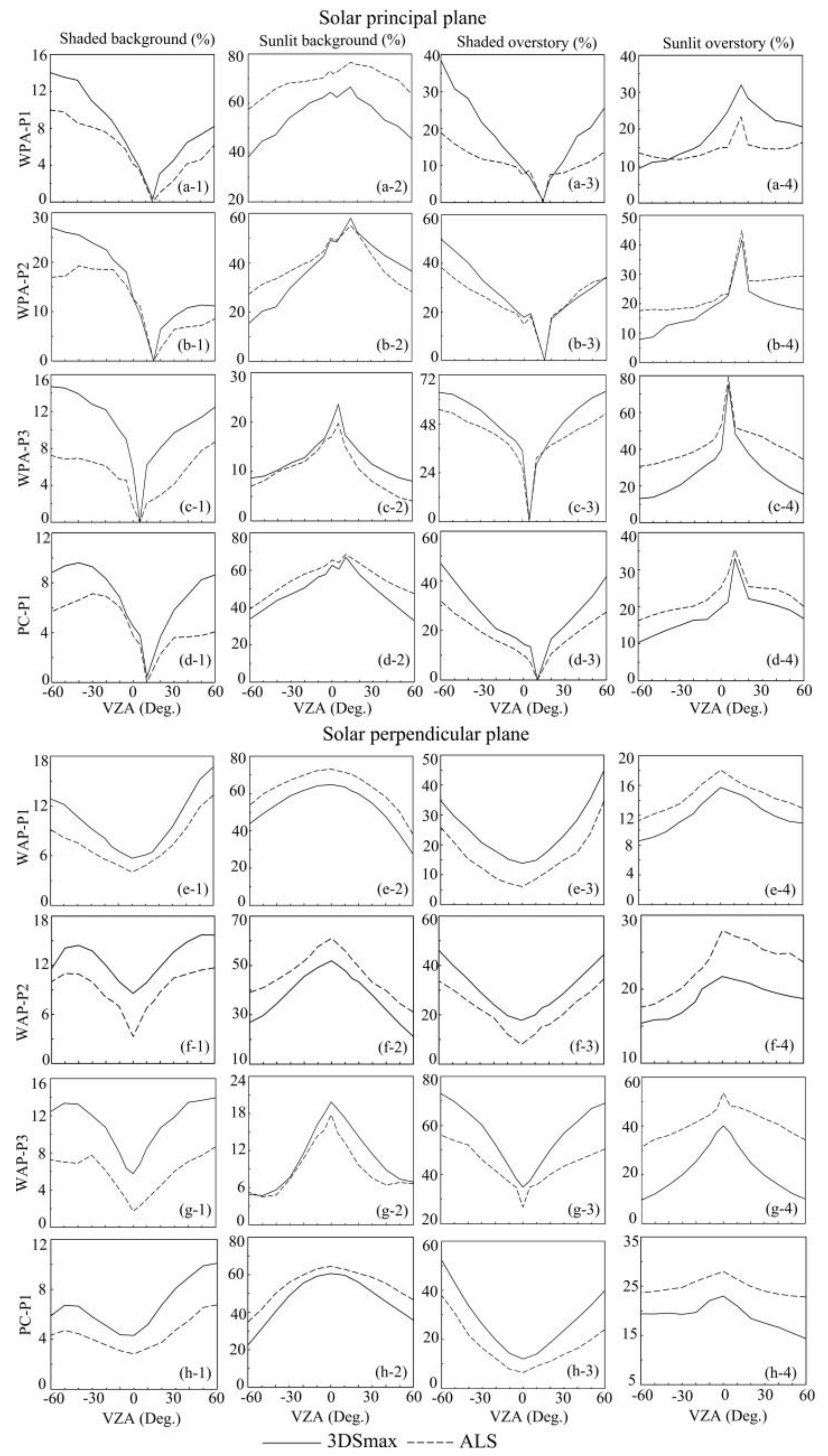
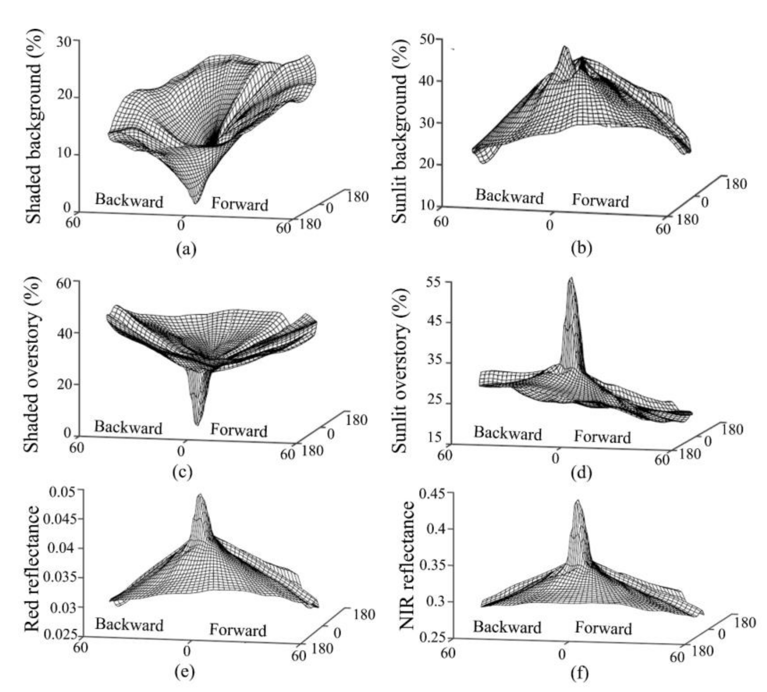
3.3.1. Spatial Variations
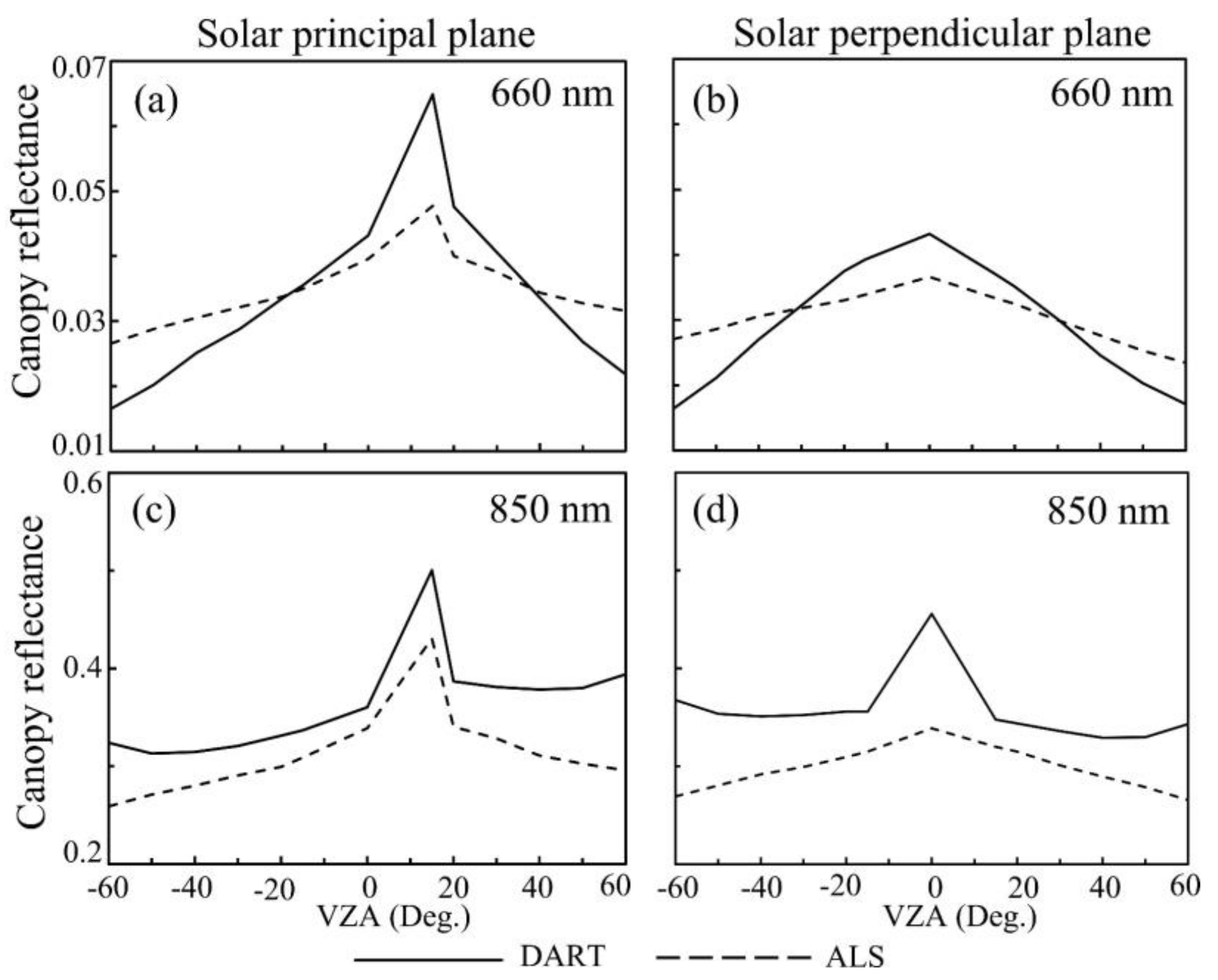
3.3.2. Comparisons with DART Simulations
4. Discussion
4.1. The Effects of ALS Data Characteristics
4.1.1. Scan Angle and Flight Path
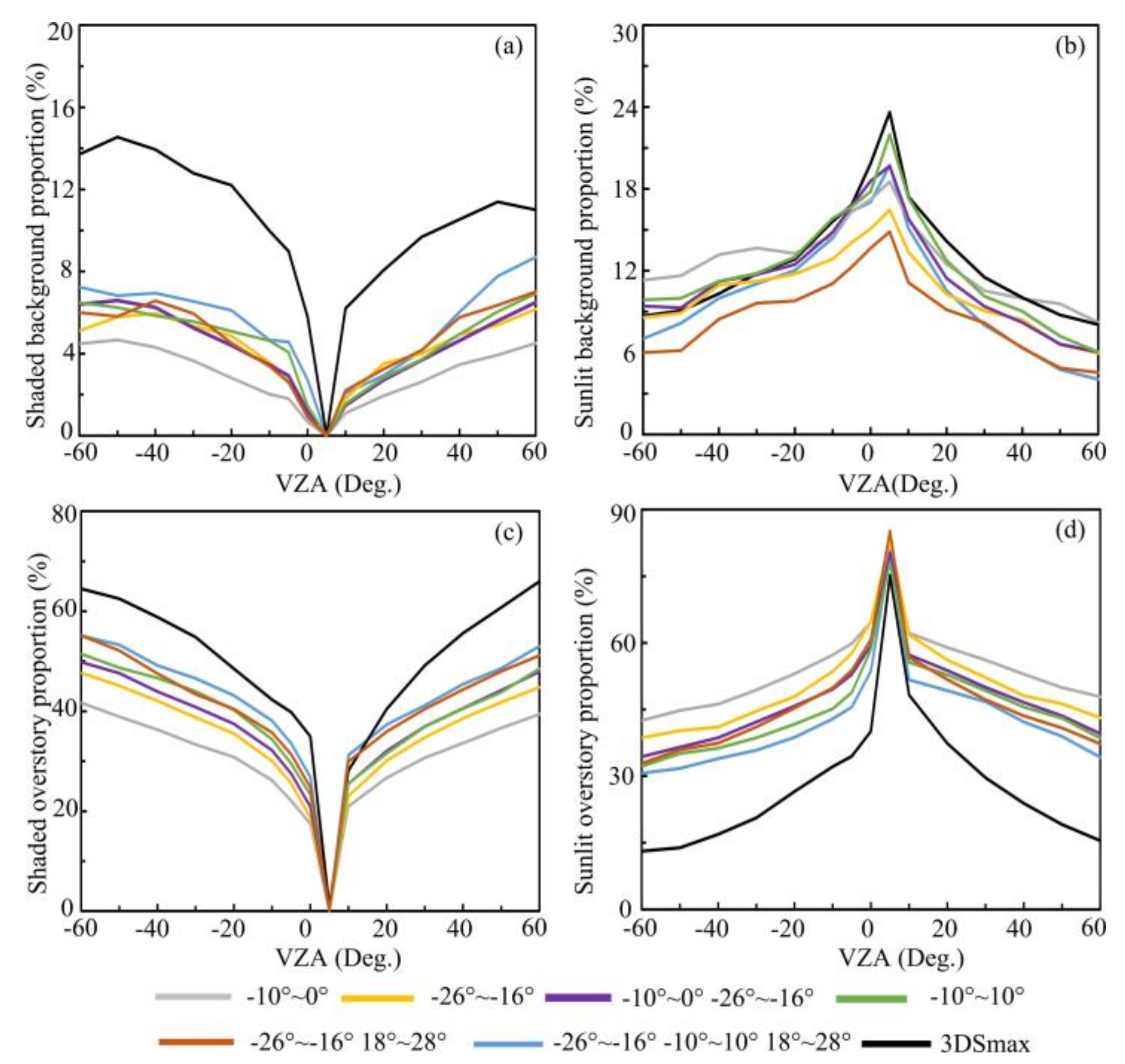
4.1.2. Optimal Scan Angle Range
4.2. Voxel Size Determination
4.3. Effects of Forest Stand Conditions
4.3.1. Canopy Cover
4.3.2. Tree Spatial Distribution
4.3.3. Tree Height and Crown Shape
4.3.4. Topographic Variations
4.3.5. Effects of Ground Points
4.4. Effects of Surrounding Forest Stands
5. Conclusions
Author Contributions
Funding
Acknowledgments
Conflicts of Interest
References
- Chen, J.M.; Leblanc, S.G. A four-scale bidirectional reflectance model based on canopy architecture. IEEE Trans. Geosci. Remote Sens. 1997, 35, 1316–1337. [Google Scholar] [CrossRef]
- Fan, W.; Jing, L.; Liu, Q. GOST2: The improvement of the canopy reflectance model GOST in separating the sunlit and shaded leaves. IEEE J. Sel. Top. Appl. Earth Observ. Remote Sens. 2015, 8, 1423–1431. [Google Scholar] [CrossRef]
- Hasegawa, K.; Izumi, T.; Matsuyama, H.; Kajiwara, K.; Honda, Y. Seasonal change of bidirectional reflectance distribution function in mature Japanese larch forests and their phenology at the foot of Mt. Yatsugatake, central Japan. Remote Sens. Environ 2018, 2019, 524–539. [Google Scholar] [CrossRef]
- Hall, F.G.; Hilker, T.; Coops, N.C.; Lyapustin, A.; Huemmrich, K.F.; Middleton, E.; Margolis, H.; Drolet, G.; Black, T.A. Multi-angle remote sensing of forest light use efficiency by observing PRI variation with canopy shadow fraction. Remote Sens. Environ. 2008, 112, 3201–3211. [Google Scholar] [CrossRef] [Green Version]
- Zhang, Q.; Chen, J.M.; Ju, W.M.; Wang, H.M.; Qiu, F.; Yang, F.T.; Fan, W.L.; Huang, Q.; Wang, Y.P.; Feng, Y.K.; et al. Improving the ability of the photochemical reflectance index to track canopy light use efficiency through differentiating sunlit and shaded leaves. Remote Sens. Environ. 2017, 194, 1–15. [Google Scholar] [CrossRef]
- Jiao, T.; Liu, R.; Liu, Y.; Pisek, J.; Chen, J.M. Mapping global seasonal forest background reflectivity with multi-angle imaging spectroradiometer data. J. Geophys. Res.-Biogeosci. 2014, 119, 1063–1077. [Google Scholar] [CrossRef]
- Pisek, J.; Rautiainen, M.; Heiskanen, J.; Mõttus, M. Retrieval of seasonal dynamics of forest understory reflectance in a northern european boreal forest from MODIS BRDF data. Remote Sens. Environ. 2012, 117, 464–468. [Google Scholar] [CrossRef]
- Pisek, J.; Rautiainen, M.; Nikopensius, M.; Raabe, K. Estimation of seasonal dynamics of understory NDVI in northern forests using MODIS BRDF data: Semi-empirical versus physically-based approach. Remote Sens. Environ. 2015, 163, 42–47. [Google Scholar] [CrossRef] [Green Version]
- Hall, F.G.; Shimabukuro, Y.E.; Huemmrich, K.F. Remote sensing of forest biophysical structure using mixture decomposition and geometric reflectance models. Ecol. Appl. 1995, 5, 993–1013. [Google Scholar] [CrossRef]
- Mu, X.; Hu, R.; Zeng, Y.; Tim, R.M.; Ren, H.; Song, W.; Wang, Y.; Casa, R.; Qi, J.; Xie, D.; et al. Estimating structural parameters of agricultural crops from ground-based multi-angular digital images with a fractional model of sun and shade components. For. Ecol. Manag. 2017, 246, 162–177. [Google Scholar] [CrossRef]
- Casa, R.; Jones, H.R. LAI retrieval from multiangular image classification and inversion of a ray tracing model. Remote Sens. Environ. 2005, 98, 414–428. [Google Scholar] [CrossRef]
- Zhang, Y.Q.; Chen, J.M.; Miller, J.R.; Noland, T.L. Leaf chlorophyll content retrieval from airborne hyperspectral remote sensing imagery. Remote Sens. Environ. 2008, 112, 3234–3247. [Google Scholar] [CrossRef]
- He, L.M.; Chen, J.M.; Gonsamo, A.; Luo, X.Z.; Wang, R.; Liu, Y.; Liu, R.G. Changes in the shadow: The shifting role of shaded leaves in global carbon and water cycles under climate change. Geophys. Res. Lett. 2018, 45, 5052–5061. [Google Scholar] [CrossRef] [Green Version]
- Geng, J.; Chen, J.M.; Fan, W.; Tu, L.; Tian, Q.; Yang, R.; Yang, Y.; Wang, L.; Lv, C.; Wu, S. GOFP: A geometric-optical model for forest plantations. IEEE Trans. Geosci. Remote Sens. 2017, 55, 5230–5241. [Google Scholar] [CrossRef]
- Leblanc, S.G.; Bicheron, P.; Chen, J.M.; Leroy, M. Investigation of directional reflectance in boreal forests with an improved four-scale model and airborne POLDER data. IEEE Trans. Geosci. Remote Sens. 1999, 37, 1396–1414. [Google Scholar] [CrossRef]
- Li, X.; Strahler, A.H. Geometric-optical bidirectional reflectance modeling of a conifer forest canopy. IEEE Trans. Geosci. Remote Sens. 1986, 906–919. [Google Scholar] [CrossRef]
- Liu, Q.; Yan, G.; Jiao, Z.; Qing, X.; Wen, J.; Liang, S.; Wang, J.; Schaaf, C.; Strahler, A. From geometric-optical remote sensing modeling to quantitative remote sensing science—In memory of academician Xiaowen Li. Remote Sens. 2018, 10, 1764. [Google Scholar] [CrossRef] [Green Version]
- Fan, W.; Chen, J.M.; Ju, W.; Zhu, G. GOST: A geometric-optical model for sloping terrains. IEEE Trans. Geosci. Remote Sens. 2014, 52, 5469–5482. [Google Scholar] [CrossRef]
- Fan, W.; Chen, J.M.; Ju, W.; Nesbitt, N. Hybrid geometric optical–radiative transfer model suitable for forests on slopes. IEEE Trans. Geosci. Remote Sens. 2014, 52, 5579–5586. [Google Scholar] [CrossRef]
- Gerard, F.; North, P. Analyzing the effect of structural variability and canopy gaps on forest BRDF using a geometric-optical model. Remote Sens. Environ. 1997, 62, 46–62. [Google Scholar] [CrossRef]
- Jin, S.; Susaki, J. A micro-topography considered Monte Carlo ray-tracing solution for open forest BRF estimation. In Proceedings of the IEEE International Geoscience and Remote Sensing Symposium (IGARSS), Fort Worth, TX, USA, 23–28 July 2017; IEEE: New York, NY, USA. [Google Scholar]
- Gastellu-Etchegorry, J.P.; Yin, T.; Lauret, N.; Cajgfinger, T.; Gregoire, T.; Grau, E.; Feret, J.; Lopes, M.; Guilleux, J.; Dedieu, G.; et al. Discrete anisotropic radiative transfer (DART 5) for modeling airborne and satellite spectroradiometer and LiDAR acquisitions of natural and urban landscapes. Remote Sens. 2015, 7, 1667–1701. [Google Scholar] [CrossRef] [Green Version]
- Roberts, O.; Bunting, P.; Hardy, A. Sensitivity Analysis of the DART Model for Forest Mensuration with Airborne Laser Scanning. Remote Sens. 2020, 12, 247. [Google Scholar] [CrossRef] [Green Version]
- Iaquinta, J.; Fouilloux, A. Influence of the heterogeneity and topography of vegetated land surfaces for remote sensing applications. In Proceedings of the 7th International Symposium on Physical Measurements and Signatures in Remote Sensing, Courchevel, Franch, 7–11 April 1997. [Google Scholar]
- Kane, V.R.; Gillespie, A.R.; McGaughey, R.; Lutz, J.A.; Ceder, K.; Franklin, J.F. Interpretation and topographic compensation of conifer canopy self-shadowing. Remote Sens. Environ. 2008, 112, 3820–3832. [Google Scholar] [CrossRef]
- Fitzgerald, G.J.; Pinter, P.J.; Hunsaker, D.J.; Clarke, T.R. Multiple shadow fractions in spectral mixture analysis of a cotton canopy. Remote Sens. Environ. 2005, 97, 526–539. [Google Scholar] [CrossRef]
- Hu, B.; Miller, J.R.; Jing, M.C.; Hollinger, A. Retrieval of the canopy leaf area index in the BOREAS flux tower sites using linear spectral mixture analysis. Remote Sens. Environ. 2004, 89, 176–188. [Google Scholar] [CrossRef]
- Peddle, D.R.; Hall, F.G.; Ledrew, E.F. Spectral mixture analysis and geometric-optical reflectance modeling of boreal forest biophysical structure. Remote Sens. Environ. 1999, 67, 288–297. [Google Scholar] [CrossRef]
- Gu, C.; Clevers, J.; Liu, X.; Tian, X.; Li, Z.; Li, Z. Predicting forest height using the GOST, Landsat 7 ETM+, and airborne LiDAR for sloping terrains in the greater khingan mountains of china. ISPRS J. Photogramm. Remote Sens. 2018, 137, 97–111. [Google Scholar] [CrossRef]
- Lefsky, M.A.; Cohen, W.B.; Acker, S.A.; Parker, G.G.; Spies, T.A.; Harding, D. Lidar remote sensing of the canopy structure and biophysical properties of douglas-fir western hemlock forests. Remote Sens. Environ. 1999, 70, 339–361. [Google Scholar] [CrossRef]
- Popescu, S.C.; Zhao, K. A voxel-based lidar method for estimating crown base height for deciduous and pine trees. Remote Sens. Environ. 2008, 112, 767–781. [Google Scholar] [CrossRef]
- Hamraz, H.; Contreras, M.A.; Zhang, J. Vertical stratification of forest canopy for segmentation of understory trees within small-footprint airborne LiDAR point clouds. ISPRS J. Photogramm. Remote Sens. 2017, 130, 385–392. [Google Scholar] [CrossRef] [Green Version]
- Brandtberg, T.; Warner, T.A.; Landenberger, R.E.; McGraw, J.B. Detection and analysis of individual leaf-off tree crowns in small footprint, high sampling density lidar data from the eastern deciduous forest in North America. Remote Sens. Environ. 2003, 85, 290–303. [Google Scholar] [CrossRef]
- Hu, B.; Li, J.; Jing, L.; Judah, A. Improving the efficiency and accuracy of individual tree crown delineation from high-density LiDAR data. Int. J. Appl. Earth Obs. Geoinf. 2014, 26, 145–155. [Google Scholar] [CrossRef]
- Clark, M.L.; Clark, D.B.; Roberts, D.A. Small-footprint lidar estimation of sub-canopy elevation and tree height in a tropical rain forest landscape. Remote Sens. Environ. 2004, 91, 68–89. [Google Scholar] [CrossRef]
- Ferraz, A.; Saatchi, S.; Mallet, C.; Meyer, V. Lidar detection of individual tree size in tropical forests. Remote Sens. Environ. 2016, 183, 318–333. [Google Scholar] [CrossRef]
- Korhonen, L.; Korpela, I.; Heiskanen, J.; Maltamo, M. Airborne discrete-return LiDAR data in the estimation of vertical canopy cover, angular canopy closure and leaf area index. Remote Sens. Environ. 2011, 115, 1065–1080. [Google Scholar] [CrossRef]
- Zheng, G.; Ma, L.; Eitel, J.; He, W.; Magney, T.S.; Moskal, L.M. Retrieving directional gap fraction, extinction coefficient, and effective leaf area index by incorporating scan angle information from discrete aerial lidar data. IEEE Trans. Geosci. Remote Sens. 2016, 55, 577–590. [Google Scholar] [CrossRef]
- Latifi, H. Characterizing forest structure by means of remote sensing: A review. In Remote Sensing-Advanced Techniques and Platforms; Escalante, B., Ed.; InTech: London, UK, 2012; pp. 953–978. [Google Scholar]
- Zimble, D.A.; Evans, D.L.; Carison, G.C.; Parker, R.C.; Grado, S.C.; Gerard, P.D. Characterizing vertical forest structure using small-footprint airborne LiDAR. Remote Sens. Environ. 2003, 87, 171–182. [Google Scholar] [CrossRef] [Green Version]
- Kobler, A.; Pfeifer, N.; Todorovski, L. Repetitive interpolation: A robust algorithm for DTM generation from aerial laser scanner data in forested terrain. Remote Sens. Environ. 2007, 108, 9–23. [Google Scholar] [CrossRef]
- Kraus, K.; Pfeifer, N. Determination of terrain models in wooded areas with airborne laser scanner data. ISPRS J. Photogramm. Remote Sens. 1998, 53, 193–203. [Google Scholar] [CrossRef]
- Su, Y.; Guo, Q.; Ma, Q.; Li, W. SRTM DEM correction in vegetated mountain areas through the integration of spaceborne LiDAR, airborne LiDAR, and optical imagery. Remote Sens. 2015, 7, 11202–11225. [Google Scholar] [CrossRef] [Green Version]
- Hilker, T.; Hall, F.G.; Coops, N.C.; Lyapustin, A.; Wang, Y.; Nesic, Z.; Grant, N.; Black, T.A.; Wulder, M.A.; Kljun, N. Remote sensing of photosynthetic light-use efficiency across two forested biomes: Spatial scaling. Remote Sens. Environ. 2010, 114, 2863–2874. [Google Scholar] [CrossRef]
- Hais, M.; Kucera, T. The influence of topography on the forest surface temperature retrieved from Landsat TM, ETM plus and ASTER thermal channels. ISPRS J. Photogramm. Remote Sens. 2009, 64, 585–591. [Google Scholar] [CrossRef]
- R Core Team. R: A Language and Environment for Statistical Computing; R Foundation for Statistical Computing: Vienna, Austria, 2013. [Google Scholar]
- Osunkoya, O.O.; Omar-Ali, K.; Amit, N.; Dayan, J.; Daud, D.S.; Sheng, T.K. Comparative height–crown allometry and mechanical design in 22 tree species of Kuala Belalong rainforest, Brunei, Borneo. Am. J. Bot. 2007, 94, 1951–1962. [Google Scholar] [CrossRef] [PubMed]
- Stoffberg, G.; Van Rooyen, M.; Van der Linde, M.; Groeneveld, H. Predicting the growth in tree height and crown size of three street tree species in the City of Tshwane, South Africa. Urban For. Urban Green. 2008, 7, 259–264. [Google Scholar] [CrossRef]
- Li, W.; Guo, Q.; Jakubowski, M.K.; Kelly, M. A new method for segmenting individual trees from the lidar point cloud. Photogramm. Eng. Remote Sens. 2012, 78, 75–84. [Google Scholar] [CrossRef] [Green Version]
- Jaskierniak, D.; Lane, P.N.; Robinson, A.; Lucieer, A. Extracting LiDAR indices to characterise multilayered forest structure using mixture distribution functions. Remote Sens. Environ. 2011, 115, 573–585. [Google Scholar] [CrossRef]
- Mauro, F.; Valbuena, R.; Manzanera, J.A.; García-Abril, A. Influence of Global Navigation Satellite System errors in positioning inventory plots for tree-height distribution studies. Can. J. For. Res. 2011, 41, 11–23. [Google Scholar] [CrossRef]
- Hosoi, F.; Omasa, K. Voxel-based 3-D modeling of individual trees for estimating leaf area density using high-resolution portable scanning lidar. IEEE Trans. Geosci. Remote Sens. 2006, 44, 3610–3618. [Google Scholar] [CrossRef]
- Zheng, G.; Moskal, L.M. Computational-geometry-based retrieval of effective leaf area index using terrestrial laser scanning. IEEE Trans. Geosci. Remote Sens. 2012, 50, 3958–3969. [Google Scholar] [CrossRef]
- Heinz, D.C. Fully constrained least squares linear spectral mixture analysis method for material quantification in hyperspectral imagery. IEEE Trans. Geosci. Remote Sens. 2001, 39, 529–545. [Google Scholar] [CrossRef] [Green Version]
- Bartier, P.M.; Keller, C.P. Multivariate interpolation to incorporate thematic surface data using inverse distance weighting (IDW). Comput. Geosci. 1996, 22, 795–799. [Google Scholar] [CrossRef]
- Holmgren, J.; Nilsson, M.; Olsson, H. Estimation of tree height and stem volume on plots using airborne laser scanning. For. Sci. 2003, 49, 419–428. [Google Scholar]
- Li, X.; Strahler, A.H. Mutual shadowing and directional reflectance of a rough surface-A geometric-optical model. In Proceedings of the 12th Annual International Symp. on Geoscience and Remote Sensing (IGARSS 92), Houston, TX, USA, 26–29 May 1992; IEEE: New York, NY, USA, 1992. [Google Scholar]
- Li, X.; Strahler, A.H. Geometric-optical bidirectional reflectance modeling of the discrete crown vegetation canopy: Effect of crown shape and mutual shadowing. IEEE Trans. Geosci. Remote Sens. 1992, 30, 276–292. [Google Scholar] [CrossRef]
- Wang, X.; Zheng, G.; Yun, Z.; Moskal, L.M. Characterizing Tree Spatial Distribution Patterns Using Discrete Aerial Lidar Data. Remote Sensing. 2020, 12, 712. [Google Scholar] [CrossRef] [Green Version]
- Rautiainen, M.; Stenberg, P.; Nilson, T.; Kuusk, A. The effect of crown shape on the reflectance of coniferous stands. Remote Sens. Environ. 2004, 89, 41–52. [Google Scholar] [CrossRef]
- Avsar, M.D. The relationships between diameter at breast height, tree height and crown diameter in calabrian pines (pinus brutia ten) of baskonus mountain, kahramanmaras, turkey. J. Biol. Sci. 2004, 4, 437–440. [Google Scholar]
- Qi, J.B.; Xie, D.H.; Guo, D.S.; Yan, G.J. A large-scale emulation system for realistic three-dimensional (3-D) forest simulation. IEEE J. Sel. Top. Appl. Earth Observ. Remote Sens. 2017, 10, 4834–4843. [Google Scholar] [CrossRef]
- Alonzo, M.; Bookhagen, B.; Roberts, D.A. Urban tree species mapping using hyperspectral and lidar data fusion. Remote Sens. Environ. 2014, 148, 70–83. [Google Scholar] [CrossRef]
- Drake, J.B.; Dubayah, R.O.; Clark, D.B.; Knox, R.G.; Blair, J.B.; Hofton, M.A.; Chazdon, R.L.; Weishampel, J.F.; Prince, S.D. Estimation of tropical forest structural characteristics using large-footprint lidar. Remote Sens. Environ. 2002, 79, 305–319. [Google Scholar] [CrossRef]
- Jones, T.G.; Coops, N.C.; Sharma, T. Assessing the utility of airborne hyperspectral and LiDAR data for species distribution mapping in the coastal Pacific Northwest, Canada. Remote Sens. Environ. 2010, 114, 2841–2852. [Google Scholar] [CrossRef]


| Plot# | Forest Type | Density | Overpass Times | Number of Scan Angles | Scan Angle Range (°) | Tree Height (m) |
|---|---|---|---|---|---|---|
| WPA-P1 | Mixed | Low | 3 | 22 | -24 ~ -11, -8 ~ 0 | 6.0 -18.0 |
| WPA-P2 | Conifer | Medium | 2 | 32 | -29 ~ -7, -3 ~ 5 | 8.7 - 31.0 |
| WPA-P2E | Mixed | Medium | 5 | 57 | -29 ~ -7, -3 ~ 10, 18 ~ 28 | 3.7 - 25.4 |
| WPA-P3 | Mixed | High | 4 | 43 | -26 ~ -16, -10 ~ 10, 18 ~ 28 | 12.0 - 34.0 |
| WPA-P4 | Conifer | Medium | 1 | 13 | 7 ~ 19 | 13.0 - 27.0 |
| PC-P1 | Conifer | Low | 2 | 22 | -10 ~ -1, 2 ~ 12 | 4.5 - 9.8 |
| PC-P2 | Conifer | Medium | 2 | 24 | -8 ~ 5, -3 ~ 6 | 33.5 - 57.2 |
| PC-P3 | Conifer | Medium | 2 | 23 | -12 ~ -1, 3 ~ 13 | 18.6 - 38.8 |
| Plot# | Tree Height (m) | Crown Diameter (m) | Stem No. | Canopy Cover (%) | Spatial Distribution Pattern | Crown Shape |
|---|---|---|---|---|---|---|
| 1 | 13 | 7.8 | 7 | 12 | regular | cone (conifer) |
| 2 | 13 | 7.8 | 14 | 23 | regular | cone (conifer) |
| 3 | 13 | 7.8 | 21 | 35 | regular | cone (conifer) |
| 4 | 13 | 7.8 | 28 | 46 | regular | cone (conifer) |
| 5 | 13 | 7.8 | 35 | 58 | regular | cone (conifer) |
| 6 | 13 | 7.8 | 43 | 71 | regular | cone (conifer) |
| 7 | 13 | 7.8 | 50 | 83 | regular | cone(conifer) |
| 8 | 13 | 7.8 | 56 | 93 | regular | cone(conifer) |
| 9 | 13 | 7.8 | 24 | 39 | regular | cone(conifer) |
| 10 | 13 | 7.8 | 42 | 37 | clumped | cone(conifer) |
| 11 | 13 | 7.8 | 42 | 71 | regular | cone(conifer) |
| 12 | 21 | 7.8 | 24 | 39 | regular | cone(conifer) |
| 13 | 21 / 13 | 7.8 | 24 | 39 | regular | cone(conifer) |
| 14 | 12 | 10.3 | 13 | 38 | regular | sphere(broadleaf) |
| 15 | 19 | 12.7 | 24 | 64 | regular | cone (conifer) |
| Plot# | WPA-P1 | WPA-P2 | WPA-P3 | PC-P1 | |
|---|---|---|---|---|---|
| Vertical stratification | Height threshold (m) | 6.0 | 6.9 | 5.4 | 3.5 |
| Original gap size (m) | 6.0 – 33.0 | 2.0 – 24.0 | 3.0 – 18.0 | 3.0 – 17.0 | |
| Overstorygap size (m) | 5.0 – 30.0 | 2.0- 22.0 | 1.0 – 13.0 | 3.0 – 15.0 | |
| Original gap size (m) | 137.0 | 179.0 | 114.0 | 144.0 | |
| Overstory gap size (m) | 116.0 | 143.0 | 64.0 | 125.0 | |
| Identification percentage (%) | 85.0 | 79.0 | 65.0 | 87.0 | |
| Gap size RMSE (m) | 2.3 | 2.7 | 4.3 | 1.8 | |
| Root mean square error (%) | Shaded background | 2.6 | 3.8 | 3.3 | 5.6 |
| Sunlit background | 12.1 | 7.0 | 2.7 | 9.8 | |
| Shaded overstory | 8.9 | 6.9 | 10.1 | 7.7 | |
| Sunlit overstory | 4.1 | 5.6 | 16.8 | 2.5 | |
| Forest background | 7.3 | 5.4 | 2.9 | 7.6 | |
| Forest overstory | 6.5 | 6.3 | 13.5 | 5.1 | |
| Background and overstory | 6.9 | 5.8 | 8.2 | 6.4 | |
| Plot# | WPA-P4 | PC-P2 | PC-P3 | |
|---|---|---|---|---|
| Vertical stratification | Height threshold (m) | 6.4 | 3.2 | 2.5 |
| Original gap size (m) | 5.0 – 17.0 | 3.0 – 10.0 | 3.0 – 9.0 | |
| Overstory gap size (m) | 4.0 – 16.0 | 1.0 – 7.0 | 1.0 – 6.0 | |
| Original gap size (m) | 143.0 | 75.0 | 53.0 | |
| Overstory gap size (m) | 102.0 | 56.0 | 36.0 | |
| Identification percentage (%) | 71.0 | 72.0 | 68.0 | |
| Gap size RMSE (m) | 3.9 | 2.5 | 2.9 | |
| Root mean square error (%) | Shaded background | 5.6 | 5.9 | 4.7 |
| Sunlit background | 9.7 | 8.1 | 8.9 | |
| Shaded overstory | 15.1 | 7.5 | 15.9 | |
| Sunlit overstory | 11.1 | 7.2 | 14.7 | |
| Forest background | 7.6 | 6.9 | 6.8 | |
| Forest overstory | 13.1 | 7.3 | 15.3 | |
| Background and overstory | 10.3 | 7.2 | 11.1 | |
| Root Mean Square Error (%) | |||||||
|---|---|---|---|---|---|---|---|
| Scan Angles (°) | Shaded Background | Sunlit Background | Shaded Overstory | Sunlit Overstory | Forest Background | Forest Overstory | Background and Overstory |
| -10° ~ 0° | 7.5 | 2.1 | 19.3 | 26.2 | 4.8 | 22.8 | 13.8 |
| -26° ~ -16° | 6.2 | 3.1 | 14.9 | 22.8 | 4.7 | 18.9 | 11.8 |
| -10° ~ 0° -26° ~ -16° | 6.2 | 2.7 | 12.9 | 19.6 | 4.5 | 16.2 | 10.4 |
| -10° ~ 10° | 5.9 | 1.3 | 11.2 | 17.3 | 3.6 | 14.3 | 9.0 |
| -26° ~ -16° 18° ~ 28° | 5.9 | 4.5 | 9.5 | 18.6 | 5.3 | 14.1 | 9.7 |
| -10° ~ 10° -26° ~ -16° 18° ~ 28° | 5.1 | 2.7 | 8.1 | 14.7 | 3.9 | 11.4 | 7.7 |
| Plane | View Azimuth Angle (°) | View Zenith Angle (°) | Four Forest Component Proportions Difference (%) | ||||
|---|---|---|---|---|---|---|---|
| Shaded Background | Sunlit Background | Shaded Overstory | Sunlit Overstory | Background and Overstory | |||
| Principal plane | 160 | 0 | 2.6 | 2.2 | 7.9 | 3.1 | 3.9 |
| 160 | 15* | 0.0 | 3.2 | 0.0 | 3.2 | 3.2 | |
| 160 | 20 | 0.1 | 2.7 | 11.8 | 8.9 | 5.9 | |
| 160 | 30 | 1.5 | 2.2 | 10.6 | 9.9 | 6.1 | |
| 160 | 40 | 4.8 | 4.9 | 11.7 | 11.6 | 8.3 | |
| 160 | 50 | 6.0 | 2.1 | 10.1 | 14.0 | 8.1 | |
| 160 | 60 | 6.5 | 12.3 | 4.6 | 23.4 | 11.7 | |
| 340 | 15 | 1.4 | 4.8 | 9.6 | 3.4 | 4.8 | |
| 340 | 20 | 0.7 | 4.2 | 8.5 | 4.7 | 4.5 | |
| 340 | 30 | 0.4 | 2.9 | 7.8 | 5.3 | 4.1 | |
| 340 | 40 | 2.1 | 0.9 | 6.2 | 7.4 | 4.2 | |
| 340 | 50 | 6.5 | 1.5 | 2.9 | 10.9 | 5.5 | |
| 340 | 60 | 13.7 | 8.3 | 3.7 | 18.5 | 11.0 | |
| Perpendicular plane | 70 | 15 | 0.0 | 5.9 | 11.3 | 5.4 | 5.7 |
| 70 | 20 | 0.4 | 6.1 | 11.3 | 5.5 | 5.8 | |
| 70 | 30 | 3.5 | 8.9 | 11.4 | 6.0 | 7.5 | |
| 70 | 40 | 6.9 | 8.6 | 10.6 | 8.8 | 8.7 | |
| 70 | 50 | 13.0 | 4.6 | 8.1 | 16.5 | 10.6 | |
| 70 | 60 | 14.4 | 1.2 | 8.1 | 23.6 | 11.8 | |
| 250 | 15 | 0.1 | 5.7 | 10.9 | 5.4 | 5.5 | |
| 250 | 20 | 1.1 | 6.8 | 10.6 | 4.9 | 5.8 | |
| 250 | 30 | 3.5 | 7.9 | 10.0 | 5.6 | 6.8 | |
| 250 | 40 | 4.6 | 7.5 | 8.7 | 5.8 | 6.6 | |
| 250 | 50 | 7.1 | 3.7 | 6.1 | 9.5 | 6.6 | |
| 250 | 60 | 7.3 | 3.2 | 3.3 | 13.8 | 6.9 | |
© 2020 by the authors. Licensee MDPI, Basel, Switzerland. This article is an open access article distributed under the terms and conditions of the Creative Commons Attribution (CC BY) license (http://creativecommons.org/licenses/by/4.0/).
Share and Cite
Wang, X.; Zheng, G.; Yun, Z.; Xu, Z.; Moskal, L.M.; Tian, Q. Characterizing the Spatial Variations of Forest Sunlit and Shaded Components Using Discrete Aerial Lidar. Remote Sens. 2020, 12, 1071. https://doi.org/10.3390/rs12071071
Wang X, Zheng G, Yun Z, Xu Z, Moskal LM, Tian Q. Characterizing the Spatial Variations of Forest Sunlit and Shaded Components Using Discrete Aerial Lidar. Remote Sensing. 2020; 12(7):1071. https://doi.org/10.3390/rs12071071
Chicago/Turabian StyleWang, Xiaofei, Guang Zheng, Zengxin Yun, Zhaoshang Xu, L. Monika Moskal, and Qingjiu Tian. 2020. "Characterizing the Spatial Variations of Forest Sunlit and Shaded Components Using Discrete Aerial Lidar" Remote Sensing 12, no. 7: 1071. https://doi.org/10.3390/rs12071071
APA StyleWang, X., Zheng, G., Yun, Z., Xu, Z., Moskal, L. M., & Tian, Q. (2020). Characterizing the Spatial Variations of Forest Sunlit and Shaded Components Using Discrete Aerial Lidar. Remote Sensing, 12(7), 1071. https://doi.org/10.3390/rs12071071