Integration of Selective Dimensionality Reduction Techniques for Mineral Exploration Using ASTER Satellite Data


 ,
,  , ,
, ,
Abstract
:
1. Introduction
2. Geological Setting
3. Materials and Methods
3.1. ASTER Data Characteristics and Pre-Processing
3.2. Image Processing
3.2.1. Principal Component Analysis
3.2.2. Independent Component Analysis
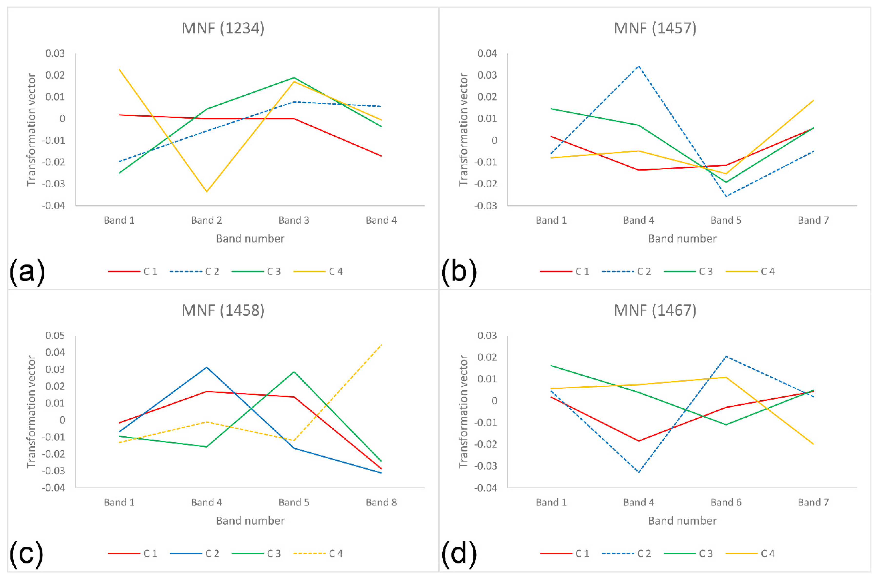
3.2.3. Minimum Noise Fraction
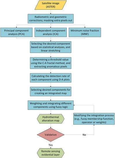
3.2.4. Hydrothermal Alteration Mapping by the PCA, ICA, and MNF Techniques
3.3. Integration of Hydrothermal Alteration Thematic Layers Using Fuzzy Logic
3.4. Field Survey
4. Results
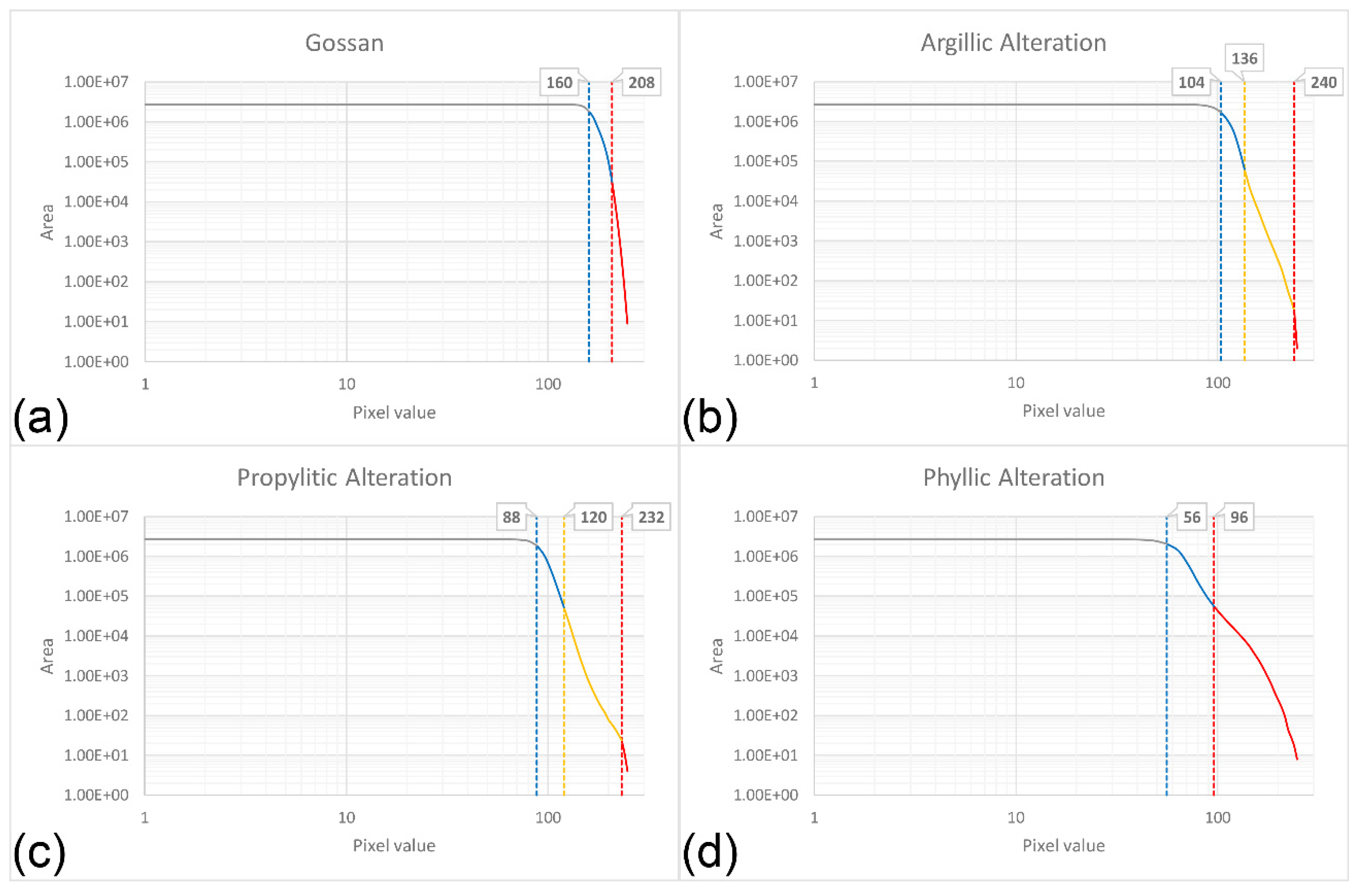
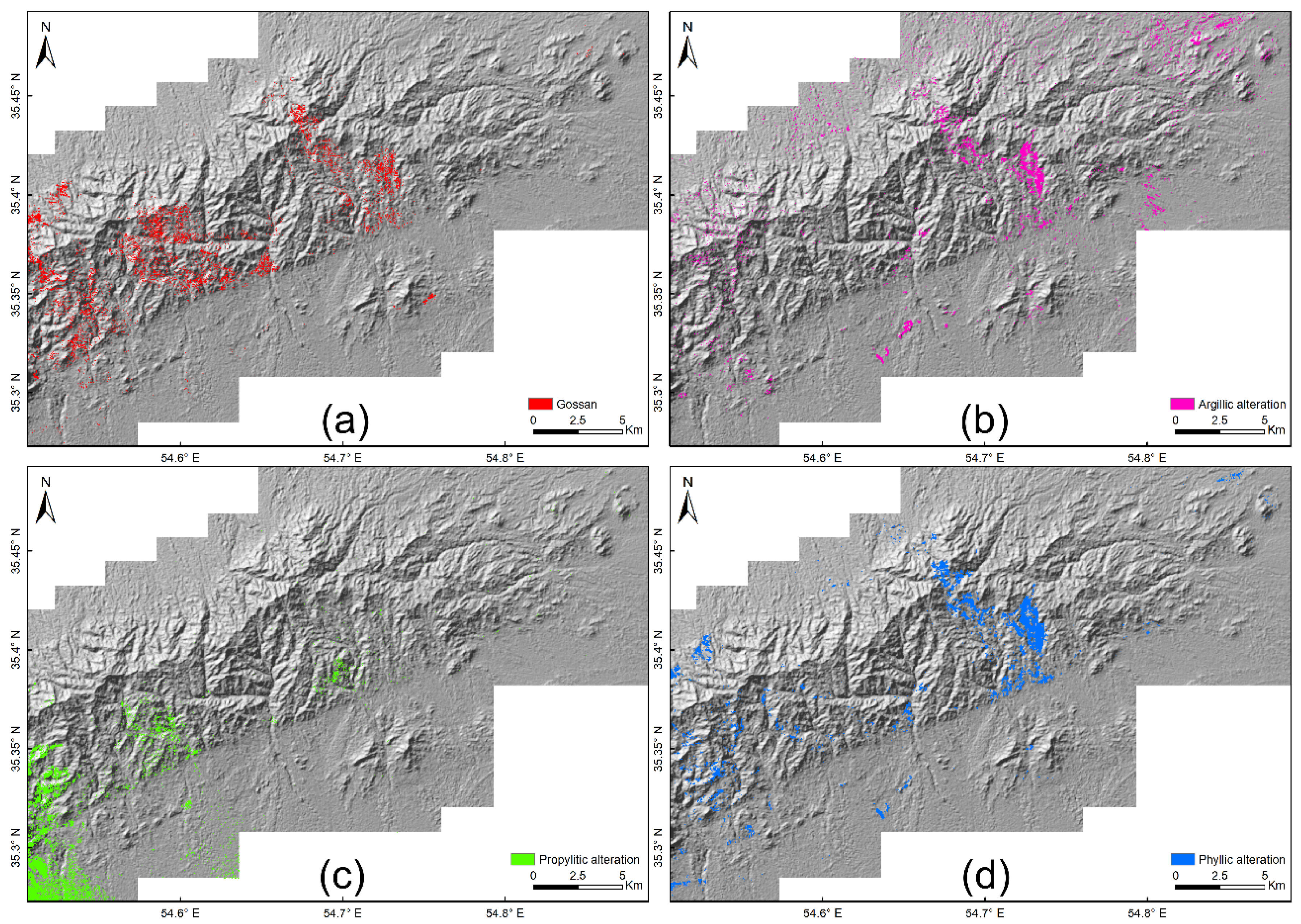
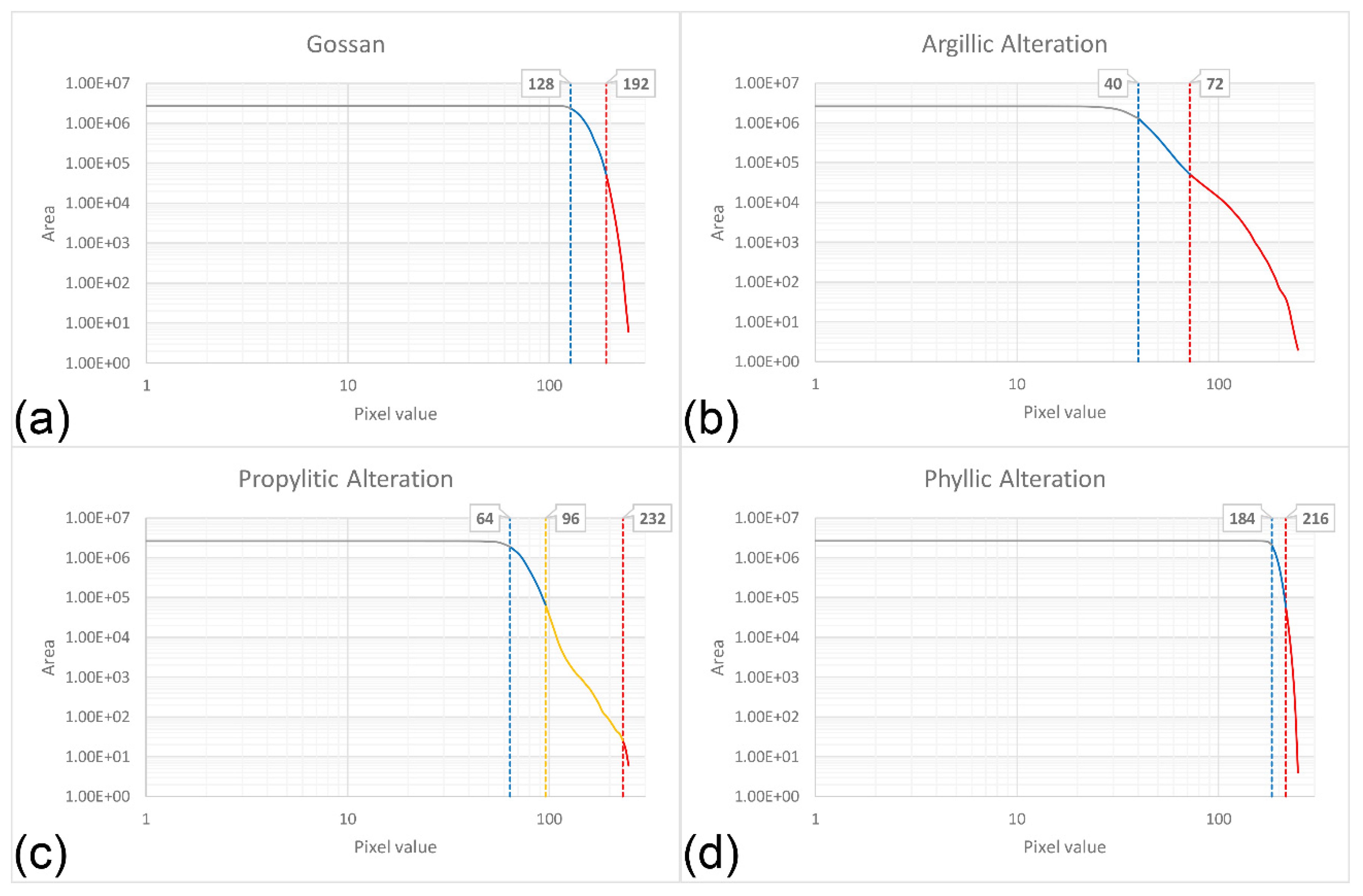
4.1. Hydrothermal Alteration Mapping Using PCA
4.2. Hydrothermal Alteration Mapping Using ICA
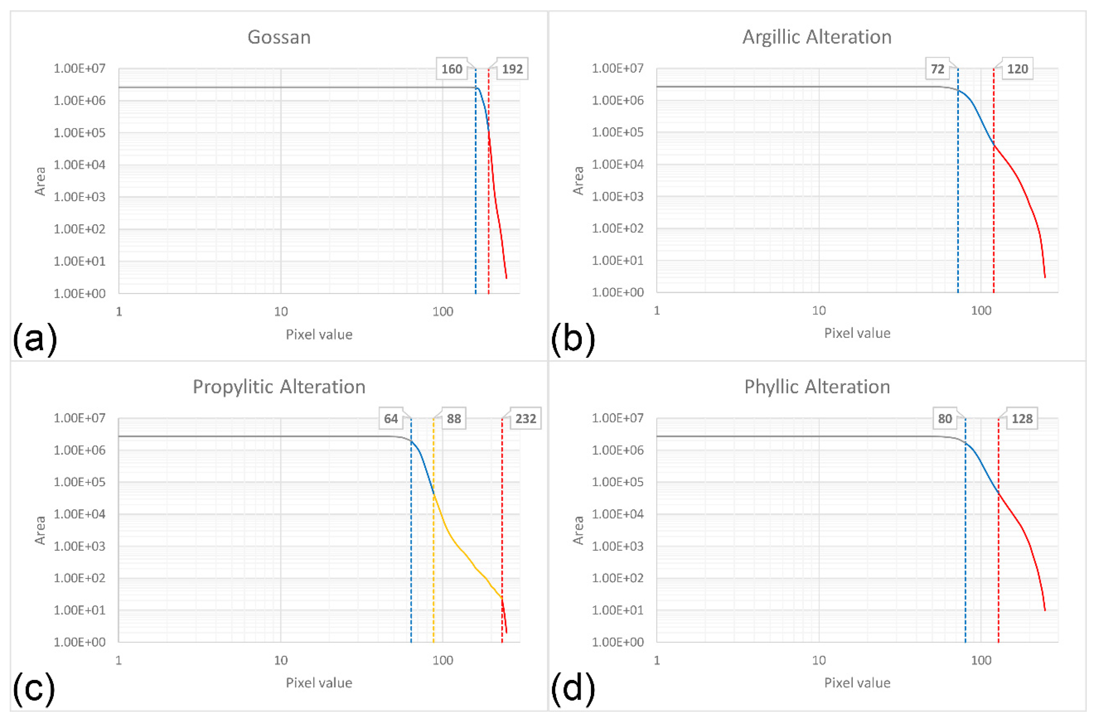
4.3. Hydrothermal Alteration Mapping Using MNF
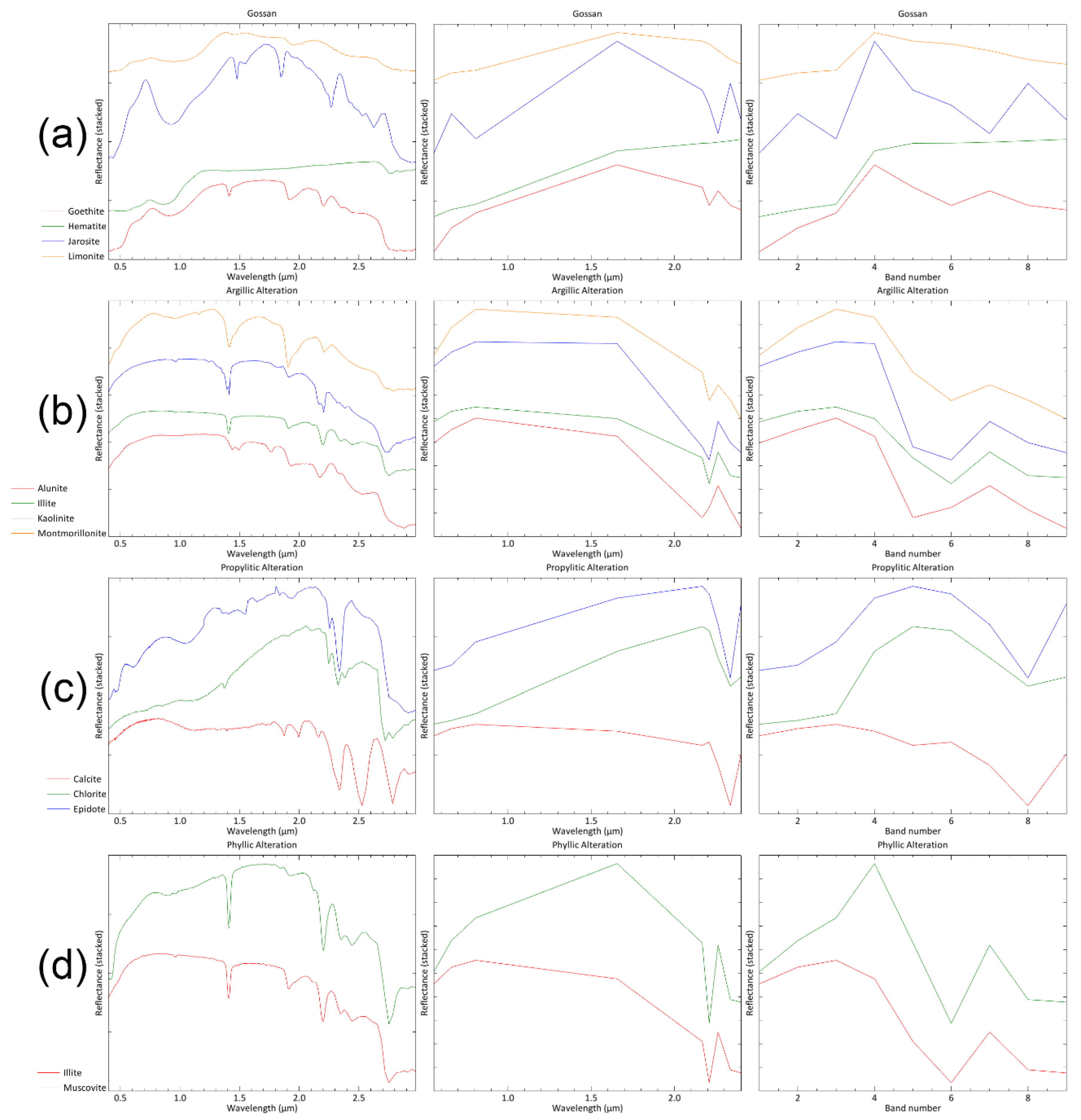
4.4. Field Data and Laboratory Analysis
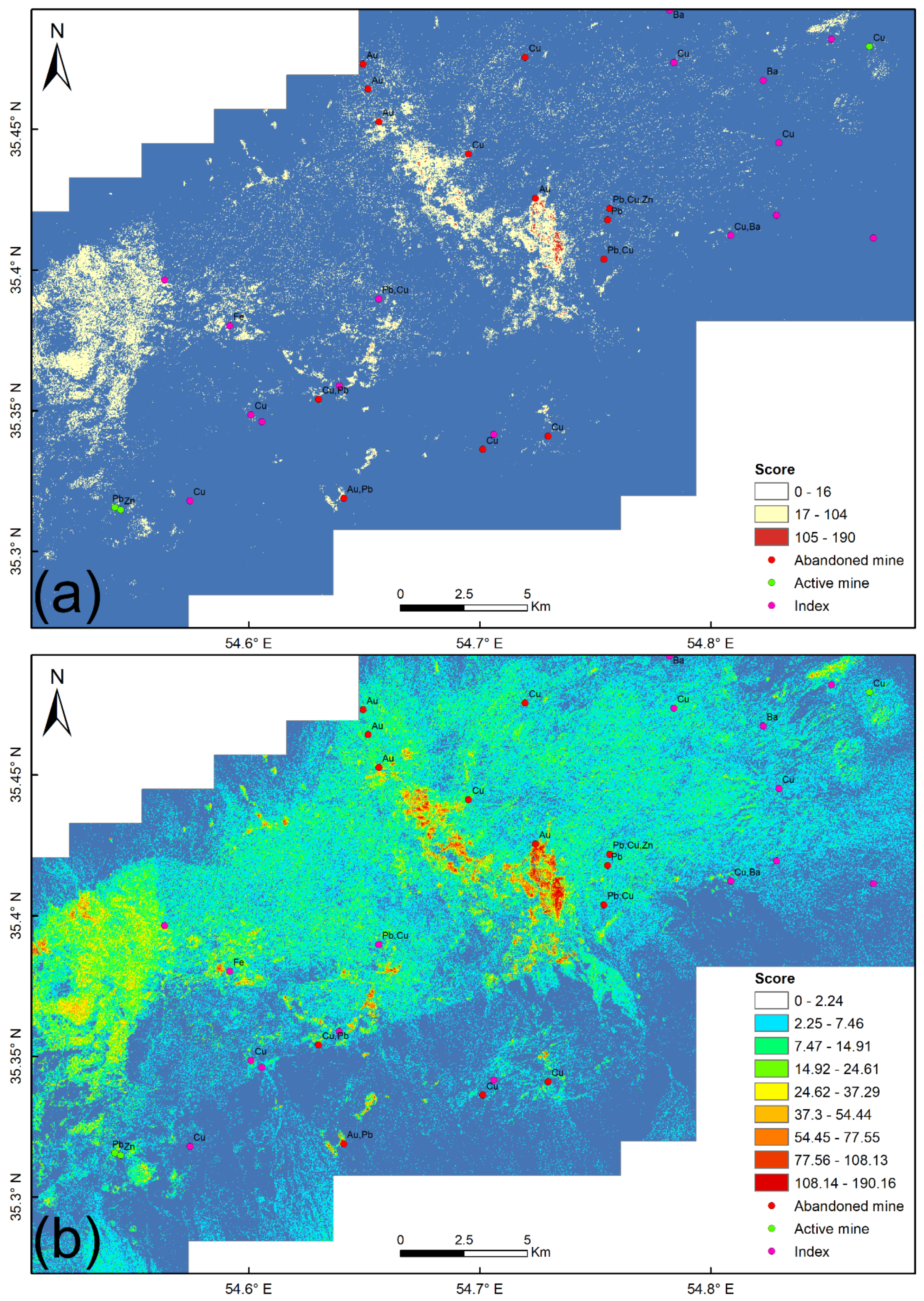
4.5. Integration of Selected Components
5. Discussion
6. Conclusions
Author Contributions
Funding
Acknowledgments
Conflicts of Interest
References
- Cooke, D.R.; Deyell, C.L.; Waters, P.J.; Gonzales, R.I.; Zaw, K. Evidence for magmatic-hydrothermal fluids and ore-forming processes in epithermal and porphyry deposits of the Baguio District, Philippines. Econ. Geol. 2011, 106, 1399–1424. [Google Scholar] [CrossRef]
- Koděra, P.; Lexa, J.; Fallick, A.E.; Wälle, M.; Biroň, A. Hydrothermal fluids in epithermal and porphyry Au deposits in the Central Slovakia Volcanic Field. Geol. Soc. London Spec. Publ. 2014, 402, 177–206. [Google Scholar] [CrossRef] [Green Version]
- Smith, D.J.; Naden, J.; Jenkin, G.R.T.; Keith, M. Hydrothermal alteration and fluid pH in alkaline-hosted epithermal systems. Ore. Geol. Rev. 2017, 89, 772–779. [Google Scholar] [CrossRef] [Green Version]
- Takahashi, R.; Tagiri, R.; Blamey, N.J.F.; Imai, A.; Watanabe, Y.; Takeuchi, A. Characteristics and behavior of hydrothermal fluids for gold mineralization at the Hishikari Deposits, Kyushu, Japan. Resour. Geol. 2017, 67, 279–299. [Google Scholar] [CrossRef]
- Bérubé, C.L.; Olivo, G.R.; Chouteau, M.; Perrouty, S.; Shamsipour, P.; Enkin, R.J.; Morris, W.A.; Feltrin, L.; Thiémonge, R. Predicting rock type and detecting hydrothermal alteration using machine learning and petrophysical properties of the Canadian Malartic ore and host rocks, Pontiac Subprovince, Québec, Canada. Ore Geol. Rev. 2018, 96, 130–145. [Google Scholar] [CrossRef]
- Mathieu, L. Quantifying hydrothermal alteration: A review of methods. Geosciences 2018, 8, 245. [Google Scholar] [CrossRef] [Green Version]
- Perrouty, S.; Linnen, R.L.; Lesher, C.M.; Olivo, G.R.; Piercey, S.J.; Gaillard, N.; Clark, J.R.; Enkin, R.J. Expanding the size of multi-parameter metasomatic footprints in gold exploration: Utilization of mafic dykes in the Canadian Malartic district, Québec, Canada. Miner. Depos. 2019, 54, 761–786. [Google Scholar] [CrossRef]
- Simpson, M.P.; Christie, A.B. Hydrothermal alteration mineralogical footprints for New Zealand epithermal Au-Ag deposits. N. Z. J. Geol. Geophys. 2019, 62, 483–512. [Google Scholar] [CrossRef]
- Rowan, L.C.; Hook, S.J.; Abrams, M.J.; Mars, J.C. Mapping hydrothermally altered rocks at Cuprite, Nevada, using the Advanced Spaceborne Thermal Emission and Reflection Radiometer (ASTER), a new satellite-imaging system. Econ. Geol. 2003, 98, 1019–1027. [Google Scholar] [CrossRef]
- Van der Meer, F.D.; van der Werff, H.M.A.; van Ruitenbeek, F.J.A.; Hecker, C.A.; Bakker, W.H.; Noomen, M.F.; van der Meijde, M.; Carranza, E.J.M.; de Smeth, J.B.; Woldai, T. Multi- and hyperspectral geologic remote sensing: A review. Int. J. Appl. Earth Obs. Geoinf. 2012, 14, 112–128. [Google Scholar] [CrossRef]
- Beiranvand Pour, A.; S Park, T.-Y.; Park, Y.; Hong, J.K.; M Muslim, A.; Läufer, A.; Crispini, L.; Pradhan, B.; Zoheir, B.; Rahmani, O. Landsat-8, advanced spaceborne thermal emission and reflection radiometer, and WorldView-3 multispectral satellite imagery for prospecting copper-gold mineralization in the Northeastern Inglefield Mobile Belt (IMB), Northwest Greenland. Remote Sens. 2019, 11, 2430. [Google Scholar] [CrossRef] [Green Version]
- Abrams, M.J.; Ashley, R.P.; Rowan, L.C.; Goetz, A.F.H.; Kahle, A.B. Mapping of hydrothermal alteration in the Cuprite mining district, Nevada, using aircraft scanner images for the spectral region 0.46 to 2.36 µm. Geology 1977, 5, 713–718. [Google Scholar] [CrossRef]
- Abrams, M.J.; Brown, D.; Lepley, L.; Sadowski, R. Remote sensing for porphyry copper deposits in southern Arizona. Econ. Geol. 1983, 78, 591–604. [Google Scholar] [CrossRef]
- Rowan, L.C.; Mars, J.C. Lithologic mapping in the Mountain Pass, California area using Advanced Spaceborne Thermal Emission and Reflection Radiometer (ASTER) data. Remote Sens. Environ. 2003, 84, 350–366. [Google Scholar] [CrossRef]
- Perry, S.L. Spaceborne and airborne remote sensing systems for mineral exploration-case histories using infrared spectroscopy. Infrared Spectrosc. Geochem. Explor. Geochem. Remote Sens. 2004, 33, 227–240. [Google Scholar]
- Mars, J.C.; Rowan, L.C. Regional mapping of phyllic- and argillic-altered rocks in the Zagros magmatic arc, Iran, using advanced spaceborne thermal emission and reflection radiometer (ASTER) data and logical operator algorithms. Geosphere 2006, 2, 161–186. [Google Scholar] [CrossRef]
- Di Tommaso, I.; Rubinstein, N. Hydrothermal alteration mapping using ASTER data in the Infiernillo porphyry deposit, Argentina. Ore Geol. Rev. 2007, 32, 275–290. [Google Scholar] [CrossRef]
- Beiranvand Pour, A.; Hashim, M.; Hong, J.K.; Park, Y. Lithological and alteration mineral mapping in poorly exposed lithologies using Landsat-8 and ASTER satellite data: North-eastern Graham Land, Antarctic Peninsula. Ore Geol. Rev. 2019, 108, 112–133. [Google Scholar] [CrossRef]
- Ahmadirouhani, R.; Karimpour, M.-H.; Rahimi, B.; Malekzadeh-Shafaroudi, A.; Pour, A.B.; Pradhan, B. Integration of SPOT-5 and ASTER satellite data for structural tracing and hydrothermal alteration mineral mapping: Implications for Cu–Au prospecting. Int. J. Image Data Fusion 2018, 9, 237–262. [Google Scholar] [CrossRef]
- Sheikhrahimi, A.; Pour, A.B.; Pradhan, B.; Zoheir, B. Mapping hydrothermal alteration zones and lineaments associated with orogenic gold mineralization using ASTER data: A case study from the Sanandaj-Sirjan Zone, Iran. Adv. Sp. Res. 2019, 63, 3315–3332. [Google Scholar] [CrossRef]
- Beiranvand Pour, A.; Park, Y.; Crispini, L.; Läufer, A.; Kuk Hong, J.; Park, T.-Y.S.; Zoheir, B.; Pradhan, B.; Muslim, A.M.; Hossain, M.S. Mapping listvenite occurrences in the damage zones of Northern Victoria Land, Antarctica using ASTER satellite remote sensing data. Remote Sens. 2019, 11, 1408. [Google Scholar] [CrossRef] [Green Version]
- Bolouki, S.M.; Ramazi, H.R.; Maghsoudi, A.; Beiranvand Pour, A.; Sohrabi, G. A remote sensing-based application of Bayesian networks for epithermal gold potential mapping in Ahar-Arasbaran area, NW Iran. Remote Sens. 2020, 12, 105. [Google Scholar] [CrossRef] [Green Version]
- Crósta, A.P.; De Souza Filho, C.R.; Azevedo, F.; Brodie, C. Targeting key alteration minerals in epithermal deposits in Patagonia, Argentina, using ASTER imagery and principal component analysis. Int. J. Remote Sens. 2003, 24, 4233–4240. [Google Scholar] [CrossRef]
- Beiranvand Pour, A.; Hashim, M. Application of advanced spaceborne thermal emission and reflection radiometer (ASTER) data in geological mapping. Int. J. Phys. Sci. 2011, 6, 7657–7668. [Google Scholar]
- Farahbakhsh, E.; Shirmard, H.; Bahroudi, A.; Eslamkish, T. Fusing ASTER and QuickBird-2 satellite data for detailed investigation of porphyry copper deposits using PCA; case study of Naysian deposit, Iran. J. Indian Soc. Remote Sens. 2016, 44, 525–537. [Google Scholar] [CrossRef]
- Rowan, L.; Goetz, A.; Ashley, R. Discrimination of hydrothermally altered and unaltered rocks in visible and near infrared multispectral images. Geophysics 1977, 42, 522–535. [Google Scholar] [CrossRef]
- Goetz, A.F.H.; Rock, B.N.; Rowan, L.C. Remote sensing for exploration; an overview. Econ. Geol. 1983, 78, 573–590. [Google Scholar] [CrossRef]
- Boardman, J.W.; Kruse, F.A. Automated spectral analysis: A geological example using AVIRIS data, north Grapevine Mountains, Nevada. In Proceedings of the 10th Thematic Conference on Geologic Remote Sensing; Environmental Research Institute of Michigan: Ann Arbor, MI, USA, 1994; pp. 1407–1418. [Google Scholar]
- Kruse, F.A.; Boardman, J.W.; Huntington, J.F. Comparison of airborne hyperspectral data and EO-1 Hyperion for mineral mapping. IEEE Trans. Geosci. Remote Sens. 2003, 41, 1388–1400. [Google Scholar] [CrossRef] [Green Version]
- Serkan Öztan, N.; Lütfi Süzen, M. Mapping evaporate minerals by ASTER. Int. J. Remote Sens. 2011, 32, 1651–1673. [Google Scholar] [CrossRef]
- Testa, F.J.; Villanueva, C.; Cooke, D.R.; Zhang, L. Lithological and hydrothermal alteration mapping of epithermal, porphyry and tourmaline breccia districts in the Argentine Andes using ASTER imagery. Remote Sens. 2018, 10, 203. [Google Scholar] [CrossRef] [Green Version]
- Singh, A.; Harrison, A. Standardized principal components. Int. J. Remote Sens. 1985, 6, 883–896. [Google Scholar] [CrossRef]
- Maćkiewicz, A.; Ratajczak, W. Principal components analysis (PCA). Comput. Geosci. 1993, 19, 303–342. [Google Scholar] [CrossRef]
- Eklundh, L.; Singh, A. A comparative analysis of standardised and unstandardised Principal Components Analysis in remote sensing. Int. J. Remote Sens. 1993, 14, 1359–1370. [Google Scholar] [CrossRef]
- Liu, J.G.; Mason, P.J. Essential Image Processing and GIS for Remote Sensing; John Wiley & Sons: Hoboken, NJ, USA, 2009; ISBN 1118724186. [Google Scholar]
- Loughlin, W.P. Principal component analysis for alteration mapping. Photogramm. Eng. Remote Sens. 1991, 57, 1163–1169. [Google Scholar]
- Zhang, X.; Pazner, M.; Duke, N. Lithologic and mineral information extraction for gold exploration using ASTER data in the south Chocolate Mountains (California). ISPRS J. Photogramm. Remote Sens. 2007, 62, 271–282. [Google Scholar] [CrossRef]
- Pour, A.B.; Hashim, M. The application of ASTER remote sensing data to porphyry copper and epithermal gold deposits. Ore Geol. Rev. 2012, 44, 1–9. [Google Scholar] [CrossRef] [Green Version]
- Benlin, X.; Fangfang, L.; Xigliang, M.; Huazhong, J. Study on independent component analysis’ application in classification and change detection of multispectral images. Int. Arch. Photogramm. Remote Sens. Spat. Inf. Sci. 2008, 37, 871–876. [Google Scholar]
- Beiranvand Pour, A.; Park, Y.; Park, T.-Y.S.; Hong, J.K.; Hashim, M.; Woo, J.; Ayoobi, I. Evaluation of ICA and CEM algorithms with Landsat-8/ASTER data for geological mapping in inaccessible regions. Geocarto Int. 2019, 34, 785–816. [Google Scholar] [CrossRef]
- Beiranvand Pour, A.; Park, T.S.; Park, Y.; Hong, J.K.; Pradhan, B. Fusion of DPCA and ICA algorithms for mineral detection using Landsat-8 spectral bands. In Proceedings of the IEEE International Geoscience and Remote Sensing Symposium, Yokohama, Japan, 28 July–2 August 2019; pp. 6067–6070. [Google Scholar]
- Green, A.A.; Berman, M.; Switzer, P.; Craig, M.D. A transformation for ordering multispectral data in terms of image quality with implications for noise removal. IEEE Trans. Geosci. Remote Sens. 1988, 26, 65–74. [Google Scholar] [CrossRef] [Green Version]
- Boardman, J.W.; Kruse, F.A.; Green, R.O. Mapping target signatures via partial unmixing of AVIRIS data. Summ. 5 Annu. JPL Airborne Geosci. Work. 1995, 1, 23–26. [Google Scholar]
- Ferrier, G.; White, K.; Griffiths, G.; Bryant, R.; Stefouli, M. The mapping of hydrothermal alteration zones on the island of Lesvos, Greece using an integrated remote sensing dataset. Int. J. Remote Sens. 2002, 23, 341–356. [Google Scholar] [CrossRef]
- Poormirzaee, R.; Oskouei, M.M. Use of spectral analysis for detection of alterations in ETM data, Yazd, Iran. Appl. Geomatics 2010, 2, 147–154. [Google Scholar] [CrossRef] [Green Version]
- Pazand, K.; Sarvestani, J.F.; Ravasan, M.R.S. Hydrothermal alteration mapping using ASTER data for reconnaissance porphyry copper mineralization in the Ahar area, NW Iran. J. Indian Soc. Remote Sens. 2013, 41, 379–389. [Google Scholar] [CrossRef]
- Shamanian, G.H.; Hedenquist, J.W.; Hattori, K.H.; Hassanzadeh, J. The Gandy and Abolhassani epithermal prospects in the Alborz magmatic arc, Semnan province, Northern Iran. Econ. Geol. 2004, 99, 691–712. [Google Scholar] [CrossRef]
- Alavi, M. Tectonostratigraphic synthesis and structural style of the Alborz mountain system in Northern Iran. J. Geodyn. 1996, 21, 1–33. [Google Scholar] [CrossRef]
- Safonov, Y.G. Hydrothermal gold deposits: Distribution, geological-genetic types, and productivity of ore-forming systems. Geol. Ore Depos. 1997, 39, 20–32. [Google Scholar]
- Eshraghi, S.A.; Jalali, A. Moaleman (1:100,000) Geological Map; Geological Survey of Iran: Tehran, Iran, 2006. [Google Scholar]
- Ramachandran, B.; Justice, C.O.; Abrams, M.J. Land Remote Sensing and Global Environmental Change: NASA’s Earth Observing System and the Science of ASTER and MODIS; Springer Science & Business Media: Berlin/Heidelberg, Germany, 2010; Volume 11, ISBN 1441967494. [Google Scholar]
- Rowan, L.C.; Mars, J.C.; Simpson, C.J. Lithologic mapping of the Mordor, NT, Australia ultramafic complex by using the Advanced Spaceborne Thermal Emission and Reflection Radiometer (ASTER). Remote Sens. Environ. 2005, 99, 105–126. [Google Scholar] [CrossRef]
- Fujisada, H. Design and performance of ASTER instrument. In Proceedings of the Advanced and Next-Generation Satellites, Paris, France, 15 December 1995; Volume 2583, pp. 16–25. [Google Scholar]
- Abrams, M. The Advanced Spaceborne Thermal Emission and Reflection Radiometer (ASTER): Data products for the high spatial resolution imager on NASA’s Terra platform. Int. J. Remote Sens. 2000, 21, 847–859. [Google Scholar] [CrossRef]
- Schwartz, G.M. Hydrothermal alteration in the “porphyry copper” deposits. Econ. Geol. 1947, 42, 319–352. [Google Scholar] [CrossRef]
- Gemmell, J.B. Exploration implications of hydrothermal alteration associated with epithermal Au-Ag deposits. ASEG Ext. Abstr. 2006, 2006, 1–5. [Google Scholar] [CrossRef]
- Simpson, M.P.; Mauk, J.L. Hydrothermal alteration and veins at the epithermal Au-Ag deposits and prospects of the Waitekauri Area, Hauraki Goldfield, New Zealand. Econ. Geol. 2011, 106, 945–973. [Google Scholar] [CrossRef]
- Alizadeh Sevari, B.; Hezarkhani, A. Fluid evolution of the magmatic hydrothermal porphyry copper deposit based on fluid inclusion and stable isotope studies at Darrehzar, Iran. ISRN Geol. 2014. [Google Scholar] [CrossRef] [Green Version]
- US Geological Survey EarthExplorer. Available online: https://earthexplorer.usgs.gov (accessed on 17 October 2019).
- Duda, K.; Daucsavage, J. ASTER Level 1T User Guide. 2015. Available online: https://lpdaac.usgs.gov/documents/262/ASTER_User_Handbook_v2.pdf (accessed on 17 October 2019).
- L3Harris Geospatial ENVI v5.3.1. Available online: https://www.harrisgeospatial.com/Software-Technology/ENVI (accessed on 9 November 2019).
- Pearson, K. On lines and planes of closest fit to systems of points in space. Philos. Mag. Ser. 6 1901, 2, 559–572. [Google Scholar] [CrossRef] [Green Version]
- Hotelling, H. Analysis of a complex of statistical variables into principal components. J. Educ. Psychol. 1933, 24, 417–441. [Google Scholar] [CrossRef]
- Jolliffe, I.T. Principal Component Analysis, 2nd ed.; Springer: New York, NY, USA, 2002. [Google Scholar]
- Yang, J.; Cheng, Q. A comparative study of independent component analysis with principal component analysis in geological objects identification, Part I: Simulations. J. Geochemical Explor. 2015, 149, 127–135. [Google Scholar] [CrossRef]
- Farahbakhsh, E.; Chandra, R.; Olierook, H.K.H.; Scalzo, R.; Clark, C.; Reddy, S.M.; Müller, R.D. Computer vision-based framework for extracting tectonic lineaments from optical remote sensing data. Int. J. Remote Sens. 2020, 41, 1760–1787. [Google Scholar] [CrossRef]
- Hall, D.L.; Llinas, J. An introduction to multisensor data fusion. In Proceedings of the IEEE; IEEE: Piscataway, NJ, USA, 1997; Volume 85, pp. 6–23. [Google Scholar]
- Tobin, D.C.; Antonelli, P.; Revercomb, H.E.; Dutcher, S.; Turner, D.D.; Taylor, J.K.; Knuteson, R.O.; Vinson, K. Hyperspectral data noise characterization using principle component analysis: Application to the atmospheric infrared sounder. J. Appl. Remote Sens. 2007, 1, 013515. [Google Scholar] [CrossRef]
- Fiori, S. Overview of independent component analysis technique with an application to synthetic aperture radar (SAR) imagery processing. Neural Networks 2003, 16, 453–467. [Google Scholar] [CrossRef]
- Hyvärinen, A. Fast and robust fixed-point algorithms for independent component analysis. IEEE Trans. Neural Networks 1999, 10, 626–634. [Google Scholar] [CrossRef] [Green Version]
- Novey, M.; Adali, T. Complex ICA by Negentropy Maximization. IEEE Trans. Neural Networks 2008, 19, 596–609. [Google Scholar] [CrossRef]
- Chiang, S.S.; Chang, C.I.; Ginsberg, I.W. Unsupervised hyperspectral image analysis using independent component analysis. In Proceedings of the IEEE International Geoscience and Remote Sensing Symposium, Honolulu, HI, USA, 24–28 July 2000; pp. 3136–3138. [Google Scholar]
- Harris, J.R.; Rogge, D.; Hitchcock, R.; Ijewliw, O.; Wright, D. Mapping lithology in Canada’s Arctic: Application of hyperspectral data using the minimum noise fraction transformation and matched filtering. Can. J. Earth Sci. 2005, 42, 2173–2193. [Google Scholar] [CrossRef]
- Clark, R.N.; Swayze, G.A.; Wise, R.; Livo, E.; Hoefen, T.; Kokaly, R.; Sutley, S.J. USGS Digital Spectral Library splib06a; US Geological Survey, Digital Data Series: Reston, VA, USA, 2007.
- Ozdemir, A.; Sahinoglu, A. Important of gossans in mineral exploration: A case study in Northern Turkey. Int. J. Earth Sci. Geophys. 2018, 4, 1–20. [Google Scholar]
- Cheng, Q.; Agterberg, F.P.; Ballantyne, S.B. The separation of geochemical anomalies from background by fractal methods. J. Geochemical Explor. 1994, 51, 109–130. [Google Scholar] [CrossRef]
- Landis, J.R.; Koch, G.G. The measurement of observer agreement for categorical data. Biometrics 1977, 33, 159–174. [Google Scholar] [CrossRef] [Green Version]
- Yousefi, M.; Nykänen, V. Data-driven logistic-based weighting of geochemical and geological evidence layers in mineral prospectivity mapping. J. Geochem. Explor. 2016, 164, 94–106. [Google Scholar] [CrossRef]
- D’Ercole, C.; Groves, D.I.; Knox-Robinson, C.M. Using fuzzy logic in a geographic information system environment to enhance conceptually based prospectivity analysis of Mississippi Valley-type mineralisation. Aust. J. Earth Sci. 2000, 47, 913–927. [Google Scholar] [CrossRef]
- Moradi, M.; Basiri, S.; Kananian, A.; Kabiri, K. Fuzzy logic modeling for hydrothermal gold mineralization mapping using geochemical, geological, ASTER imageries and other geo-data, a case study in Central Alborz, Iran. Earth Sci. Informatics 2015, 8, 197–205. [Google Scholar] [CrossRef]
- Zhang, N.; Zhou, K.; Du, X. Application of fuzzy logic and fuzzy AHP to mineral prospectivity mapping of porphyry and hydrothermal vein copper deposits in the Dananhu-Tousuquan island arc, Xinjiang, NW China. J. African Earth Sci. 2017, 128, 84–96. [Google Scholar] [CrossRef]
- Esmaeily, D.; Afshooni, S.Z.; Mirnejad, H.; Rashidnejad-e-Omran, N. Mass changes during hydrothermal alteration associated with gold mineralization in the Astaneh granitoid rocks, western Iran. Geochem. Explor. Environ. Anal. 2012, 12, 161–175. [Google Scholar] [CrossRef]
- Zhang, Y.; Gao, J.-F.; Ma, D.; Pan, J. The role of hydrothermal alteration in tungsten mineralization at the Dahutang tungsten deposit, South China. Ore Geol. Rev. 2018, 95, 1008–1027. [Google Scholar] [CrossRef]
- Pollard, P.J. An intrusion-related origin for Cu–Au mineralization in iron oxide–copper–gold (IOCG) provinces. Miner. Depos. 2006, 41, 179. [Google Scholar] [CrossRef]
- Xiao, B.; Chen, H.; Hollings, P.; Wang, Y.; Yang, J.; Wang, F. Element transport and enrichment during propylitic alteration in Paleozoic porphyry Cu mineralization systems: Insights from chlorite chemistry. Ore Geol. Rev. 2018, 102, 437–448. [Google Scholar] [CrossRef]
- Bonham-Carter, G.F. Geographic Information Systems for Geoscientists: Modeling with GIS. Comput. Methods Geosci. 1994, 13, 398. [Google Scholar]
- Yousefi, M.; Carranza, E.J.M. Prediction-area (P-A) plot and C-A fractal analysis to classify and evaluate evidential maps for mineral prospectivity modeling. Comput. Geosci. 2015, 79, 69–81. [Google Scholar] [CrossRef]
- Langlois, D.; Chartier, S.; Gosselin, D. An introduction to independent component analysis: InfoMax and FastICA algorithms. Tutor. Quant. Methods Psychol. 2010, 6, 31–38. [Google Scholar] [CrossRef] [Green Version]
- Foody, G.M. Explaining the unsuitability of the kappa coefficient in the assessment and comparison of the accuracy of thematic maps obtained by image classification. Remote Sens. Environ. 2020, 239, 111630. [Google Scholar] [CrossRef]
- Shokouh Saljoughi, B.; Hezarkhani, A.; Farahbakhsh, E. A comparison between knowledge-driven fuzzy and data-driven artificial neural network approaches for prospecting porphyry Cu mineralization; A case study of Shahr-e-Babak area, Kerman Province, SE Iran. J. Min. Environ. 2018, 9, 917–940. [Google Scholar]
- De Smith, M.J.; Goodchild, M.F.; Longley, P. Geospatial Analysis: A Comprehensive Guide to Principles, Techniques and Software Tools; Troubador Publishing Ltd.: Leicester, UK, 2007; ISBN 1905886608. [Google Scholar]


| Eigenvectors | Band 1 | Band 2 | Band 3 | Band 4 |
|---|---|---|---|---|
| PC 1 | 0.341997 | 0.472648 | 0.499262 | 0.640608 |
| PC 2 | 0.321681 | 0.413772 | 0.371346 | −0.76643 |
| PC 3 | −0.680078 | −0.19108 | 0.706279 | −0.046394 |
| PC 4 | 0.563075 | −0.754244 | 0.337652 | −0.007266 |
| Eigenvectors | Band 1 | Band 4 | Band 5 | Band 7 |
|---|---|---|---|---|
| PC 1 | 0.207235 | 0.505504 | 0.51344 | 0.66174 |
| PC 2 | 0.947905 | −0.240599 | −0.203849 | 0.045107 |
| PC 3 | 0.202174 | 0.78474 | −0.113303 | −0.574867 |
| PC 4 | 0.132878 | −0.266011 | 0.825825 | −0.47916 |
| Eigenvectors | Band 1 | Band 4 | Band 5 | Band 8 |
|---|---|---|---|---|
| PC 1 | −0.264923 | −0.649083 | −0.657148 | −0.276883 |
| PC 2 | −0.953077 | 0.22522 | 0.19047 | −0.068121 |
| PC 3 | −0.050172 | −0.725165 | 0.666135 | 0.166981 |
| PC 4 | −0.13763 | −0.045865 | −0.296886 | 0.943829 |
| Eigenvectors | Band 1 | Band 4 | Band 6 | Band 7 |
|---|---|---|---|---|
| PC 1 | 0.18246 | 0.442498 | 0.657435 | 0.581965 |
| PC 2 | 0.961565 | −0.24002 | −0.130325 | 0.028251 |
| PC 3 | 0.120262 | 0.801479 | −0.585627 | 0.014461 |
| PC 4 | −0.166245 | −0.322827 | −0.455889 | 0.812595 |
| Transformation Vectors | Band 1 | Band 2 | Band 3 | Band 4 |
|---|---|---|---|---|
| C 1 | 0.001754 | −0.00002 | 0.000029 | −0.01711 |
| C 2 | −0.01966 | −0.00557 | 0.007738 | 0.005621 |
| C 3 | −0.024987 | 0.004426 | 0.018885 | −0.00362 |
| C 4 | 0.022636 | −0.033569 | 0.017022 | −0.000533 |
| Transformation Vectors | Band 1 | Band 2 | Band 3 | Band 4 |
|---|---|---|---|---|
| C 1 | 0.001734 | −0.013649 | −0.011389 | 0.005532 |
| C 2 | −0.005871 | 0.034231 | −0.025712 | −0.005107 |
| C 3 | 0.014524 | 0.007016 | −0.019229 | 0.005719 |
| C 4 | −0.008015 | −0.004828 | −0.015279 | 0.018378 |
| Transformation Vectors | Band 1 | Band 2 | Band 3 | Band 4 |
|---|---|---|---|---|
| C 1 | −0.001556 | 0.016958 | 0.013699 | −0.028643 |
| C 2 | −0.006848 | 0.031257 | −0.016662 | −0.03121 |
| C 3 | −0.009486 | −0.015755 | 0.028617 | −0.024276 |
| C 4 | −0.013196 | −0.00112 | −0.012047 | 0.044362 |
| Transformation Vectors | Band 1 | Band 2 | Band 3 | Band 4 |
|---|---|---|---|---|
| C 1 | 0.001676 | −0.01846 | −0.003035 | 0.004273 |
| C 2 | 0.004374 | −0.032869 | 0.020412 | 0.001996 |
| C 3 | 0.016131 | 0.003897 | −0.010992 | 0.004757 |
| C 4 | 0.005622 | 0.007379 | 0.010819 | −0.019848 |
| Ground Truth | ||||
|---|---|---|---|---|
| PCA | Gossan | Argillic | Propylitic | Phyllic |
| Gossan | 14 | 1 | 0 | 0 |
| Argillic | 1 | 11 | 0 | 3 |
| Propylitic | 1 | 0 | 9 | 0 |
| Phyllic | 0 | 2 | 0 | 13 |
| Overall accuracy | 0.85 | |||
| ICA | ||||
| Gossan | 13 | 1 | 0 | 1 |
| Argillic | 0 | 13 | 0 | 2 |
| Propylitic | 2 | 0 | 8 | 0 |
| Phyllic | 0 | 1 | 0 | 14 |
| Overall accuracy | 0.87 | |||
| MNF | ||||
| Gossan | 12 | 2 | 0 | 1 |
| Argillic | 0 | 14 | 0 | 1 |
| Propylitic | 3 | 0 | 7 | 0 |
| Phyllic | 0 | 3 | 0 | 12 |
| Overall accuracy | 0.81 | |||
© 2020 by the authors. Licensee MDPI, Basel, Switzerland. This article is an open access article distributed under the terms and conditions of the Creative Commons Attribution (CC BY) license (http://creativecommons.org/licenses/by/4.0/).
Share and Cite
Shirmard, H.; Farahbakhsh, E.; Beiranvand Pour, A.; Muslim, A.M.; Müller, R.D.; Chandra, R. Integration of Selective Dimensionality Reduction Techniques for Mineral Exploration Using ASTER Satellite Data. Remote Sens. 2020, 12, 1261. https://doi.org/10.3390/rs12081261
Shirmard H, Farahbakhsh E, Beiranvand Pour A, Muslim AM, Müller RD, Chandra R. Integration of Selective Dimensionality Reduction Techniques for Mineral Exploration Using ASTER Satellite Data. Remote Sensing. 2020; 12(8):1261. https://doi.org/10.3390/rs12081261
Chicago/Turabian StyleShirmard, Hodjat, Ehsan Farahbakhsh, Amin Beiranvand Pour, Aidy M Muslim, R. Dietmar Müller, and Rohitash Chandra. 2020. "Integration of Selective Dimensionality Reduction Techniques for Mineral Exploration Using ASTER Satellite Data" Remote Sensing 12, no. 8: 1261. https://doi.org/10.3390/rs12081261
APA StyleShirmard, H., Farahbakhsh, E., Beiranvand Pour, A., Muslim, A. M., Müller, R. D., & Chandra, R. (2020). Integration of Selective Dimensionality Reduction Techniques for Mineral Exploration Using ASTER Satellite Data. Remote Sensing, 12(8), 1261. https://doi.org/10.3390/rs12081261