Assessment of Urban Dynamics to Understand Spatiotemporal Differentiation at Various Scales Using Remote Sensing and Geospatial Tools

 ,
, 
Abstract
:
1. Introduction
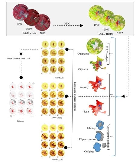
2. Materials and Methods
2.1. Study Area
2.2. Data Processing and Land-Use and Land-Cover (LULC) Classification
2.3. Spatial Pattern-Process Analysis
2.3.1. Measuring Expansion Rate and Intensity
2.3.2. Multi-Scale Landscape Metrics Analysis
2.3.3. Growth Type Analysis
- (1)
- Infilling growth type: a new urban patch is surrounded by at least 50% of existing urban patches i.e., 50 < LEI .
- (2)
- Edge-expansion type: a new urban patch is surrounded by less than 50% of existing urban patches i.e., 0 < LEI 50.
- (3)
- Outlying growth type: a new urban patch is not surrounded by any existing urban patch i.e., LEI = 0
2.4. Geospatial Statistical Analysis
3. Results
3.1. Spatiotemporal LULC Changes
3.2. Analysis of Spatial Urbanization Processes
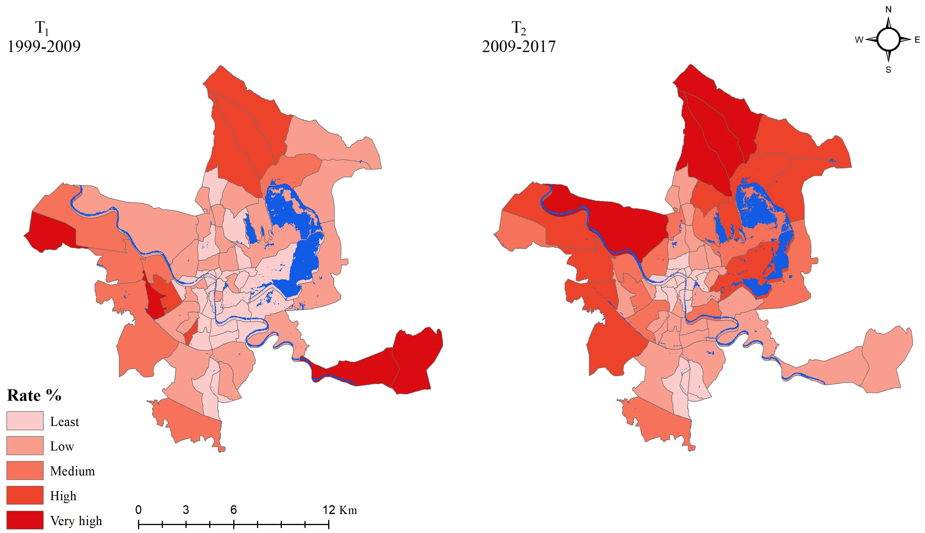
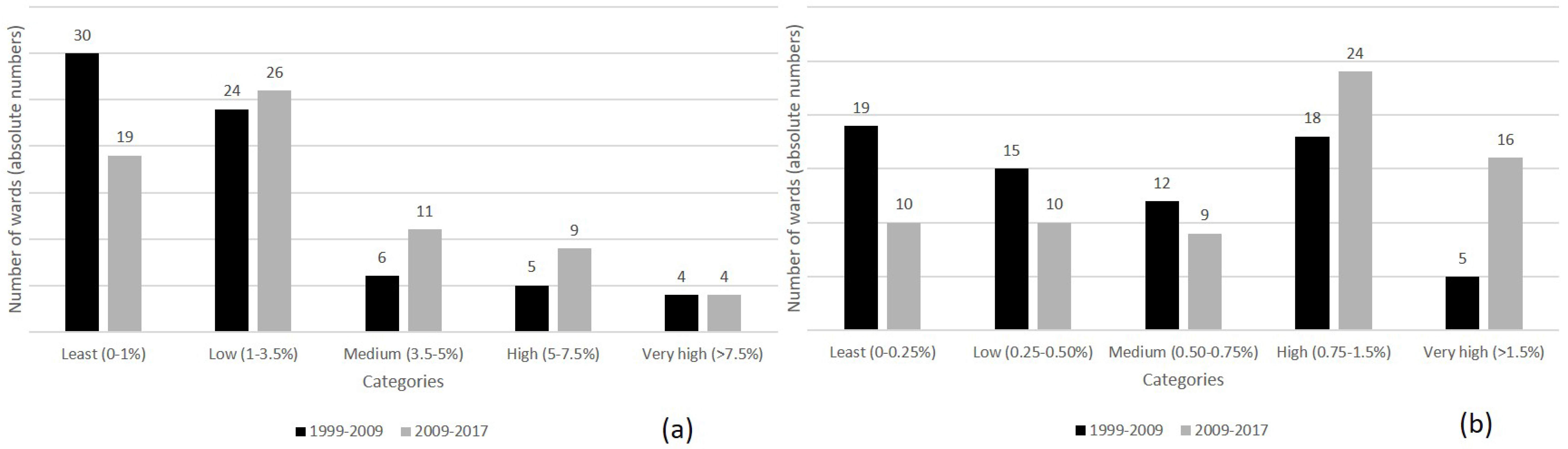
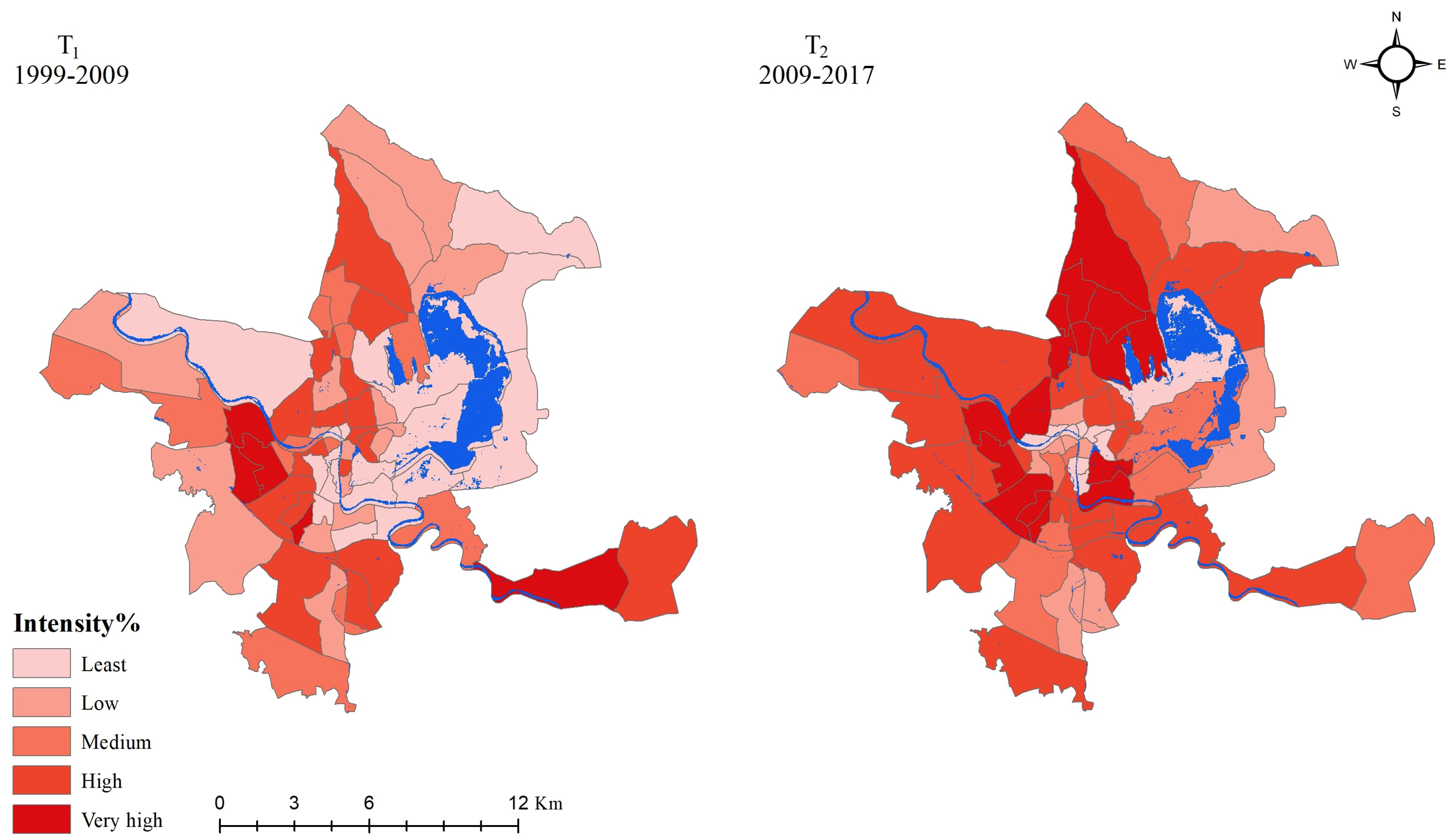
3.2.1. Quantification of Expansion Rate and Intensity
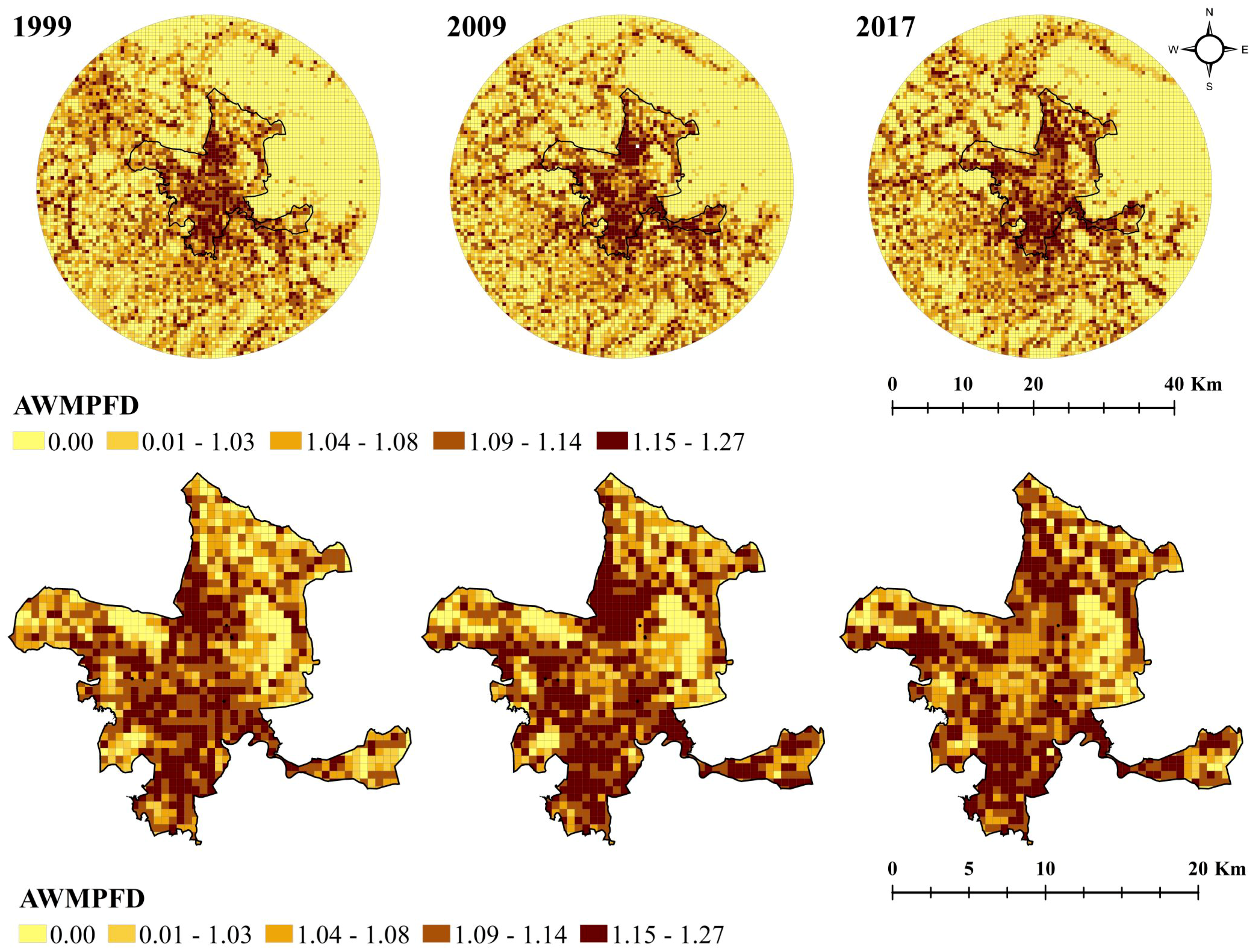
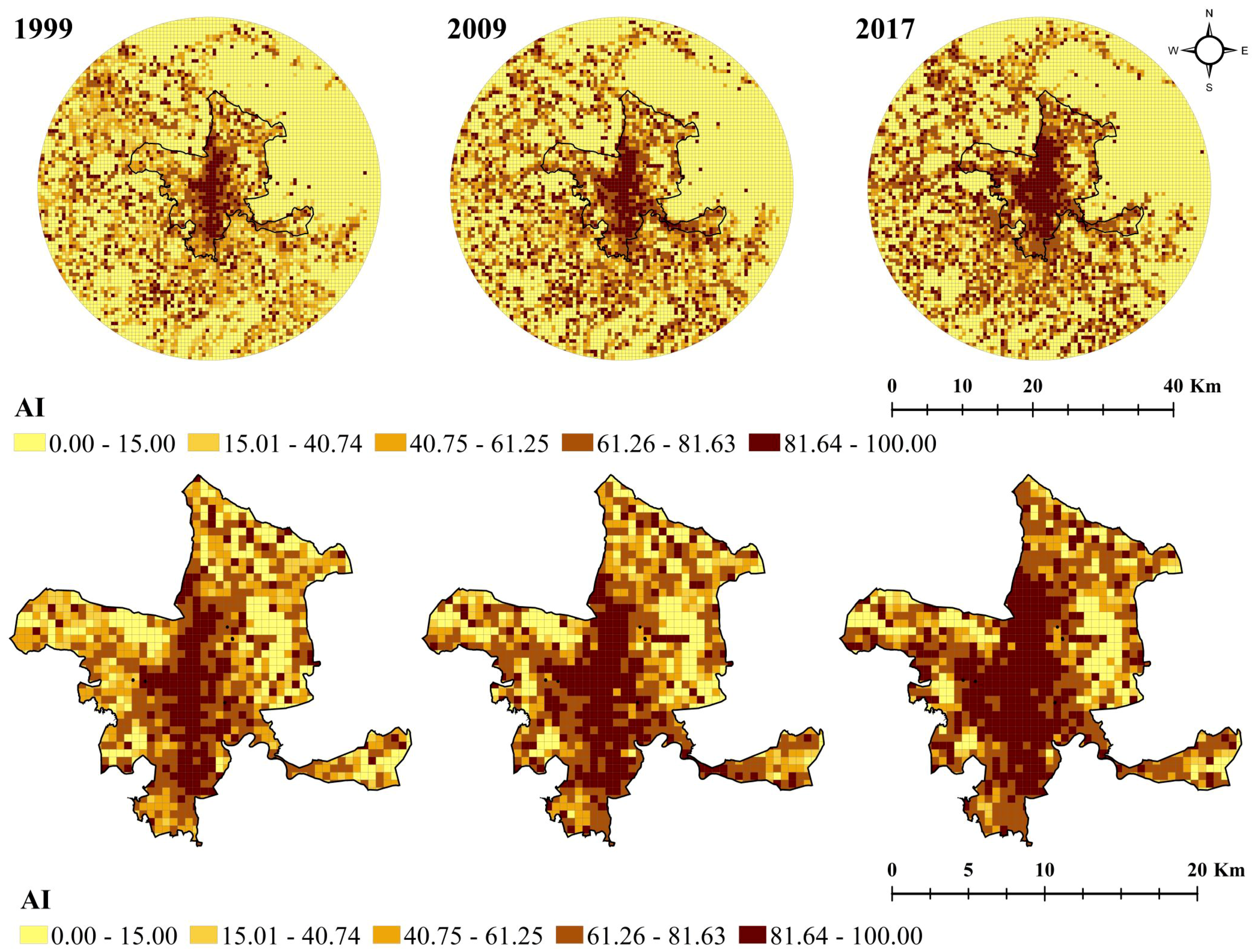
3.2.2. Spatiotemporal Trends in Landscape Metrics
3.2.3. Cluster Analysis of Landscape Structure
3.2.4. Spatiotemporal Distribution of Growth Types
4. Discussion
4.1. Spatiotemporal Evolution of the Urban Landscape
4.2. Role of Topography, Land-Use Policies, and Recommendations for Spatial Planning
4.3. Methodological Improvements and Limitations
5. Conclusions
- Srinagar has experienced considerable urban growth at the expense of fertile agricultural land, forest and open land. In the absence of any major urban centre nearby, Srinagar city has accommodated most of the growth in the region, while outside the city boundary expansion was observed mainly in the south and south-eastern region. Within the city, the rate and intensity of different built-up areas in wards highlight spatial variation in two time periods. Identification of specific wards undergoing rapid changes in the city is an important step towards implementing urban planning measures and resolving the reduction in open and green spaces.
- The analysis of landscape metrics based on spatial differentiation helps in deducing the inner urban structural pattern of the city. At the selected 500 m cell size, areas were identified experiencing irregular, fragmented and compact growth. An integrated approach to quantifying urban expansion by means of landscape metrics and further identification of hotspots using spatial autocorrelation is highly efficient and feasible, providing scientific criteria to prioritize areas that require appropriate policy implementation.
- In terms of urban growth typology, Srinagar city is dominated by the edge-expansion growth type, then followed by the infilling and outlying types. In association with landscape metrics results, the urban development trajectory of Srinagar points towards a mixed phase of different growth processes. Over the span of almost three decades, the city experienced a domination of diffusion in the initial year of investigation, followed by the dominance of a coalescence phase. Increased irregularity and fragmentation beyond the urban core, and increased aggregation and homogeneity within the core highlight the continuum of diffusion-coalescence even within the prevalent phase mentioned.
Supplementary Materials
Author Contributions
Funding
Acknowledgments
Conflicts of Interest
References
- McDonnell, M.J.; Pickett, S.T.A. Ecosystem Structure and Function along Urban-Rural Gradients: An Unexploited Opportunity for Ecology. Ecology 1990, 71, 1232–1237. [Google Scholar] [CrossRef]
- Pickett, S.T.A.; Cadenasso, M.L.; Grove, J.M.; Boone, C.G.; Groffman, P.M.; Irwin, E.; Kaushal, S.S.; Marshall, E.; McGrath, B.P.; Nilon, C.H.; et al. Urban ecological systems: Scientific foundations and a decade of progress. J. Environ. Manage. 2011, 92, 331–362. [Google Scholar] [CrossRef] [PubMed]
- Banzhaf, E.; Kabisch, S.; Knapp, S.; Rink, D.; Wolff, M.; Kindler, A. Integrated research on land-use changes in the face of urban transformations—An analytic framework for further studies. Land Use Policy 2017, 60, 403–407. [Google Scholar] [CrossRef]
- Zhang, X.Q. The trends, promises and challenges of urbanisation in the world. Habitat Int. 2016, 54, 241–252. [Google Scholar] [CrossRef]
- Bai, X.; Shi, P.; Liu, Y. Realizing China’s urban dream. Nature 2014, 509, 158–160. [Google Scholar] [CrossRef] [PubMed] [Green Version]
- Swerts, E.; Pumain, D.; Denis, E. The future of India’s urbanization. Futures 2014, 56, 43–52. [Google Scholar] [CrossRef] [Green Version]
- United Nations, Department of Economic and Social Affairs PD. World Urbanization Prospects: The 2018 Revision (ST/ESA/SER.A/420); United Nations: New York, NY, USA, 2019. [Google Scholar]
- Klopp, J.M.; Petretta, D.L. The urban sustainable development goal: Indicators, complexity and the politics of measuring cities. Cities 2017, 63, 92–97. [Google Scholar] [CrossRef]
- Bettencourt, L.M.A. The Origins of Scaling in Cities. Science 2013, 340, 1438–1442. [Google Scholar] [CrossRef] [Green Version]
- McPhearson, T.; Haase, D.; Kabisch, N.; Gren, Å. Advancing understanding of the complex nature of urban systems. Ecol. Indic. 2016, 70, 566–573. [Google Scholar] [CrossRef]
- Lausch, A.; Blaschke, T.; Haase, D.; Herzog, F.; Syrbe, R.U.; Tischendorf, L.; Walz, U. Understanding and quantifying landscape structure—A review on relevant process characteristics, data models and landscape metrics. Ecol. Modell. 2015, 295, 31–41. [Google Scholar] [CrossRef]
- Wang, H.; He, Q.; Liu, X.; Zhuang, Y.; Hong, S. Global urbanization research from 1991 to 2009: A systematic research review. Landsc. Urban Plan. 2012, 104, 299–309. [Google Scholar] [CrossRef]
- Zhu, Z.; Zhou, Y.; Seto, K.C.; Stokes, E.C.; Deng, C.; Pickett, S.T.A.; Taubenbock, H. Understanding an urbanizing planet: Strategic directions for remote sensing. Remote Sens. Environ. 2019, 228, 164–182. [Google Scholar] [CrossRef]
- Seto, K.C.; Sánchez-Rodríguez, R.; Fragkias, M. The New Geography of Contemporary Urbanization and the Environment. Annu. Rev. Environ. Resour. 2010, 35, 167–194. [Google Scholar] [CrossRef] [Green Version]
- Estoque, R.C.; Murayama, Y. Intensity and spatial pattern of urban land changes in the megacities of Southeast Asia. Land Use Policy 2015, 48, 213–222. [Google Scholar] [CrossRef]
- Dadashpoor, H.; Azizi, P.; Moghadasi, M. Land use change, urbanization, and change in landscape pattern in a metropolitan area. Sci. Total Environ. 2019, 655, 707–719. [Google Scholar] [CrossRef] [PubMed]
- Fan, C.; Myint, S. A comparison of spatial autocorrelation indices and landscape metrics in measuring urban landscape fragmentation. Landsc. Urban Plan. 2014, 121, 117–128. [Google Scholar] [CrossRef]
- Su, S.; Jiang, Z.; Zhang, Q.; Zhang, Y. Transformation of agricultural landscapes under rapid urbanization: A threat to sustainability in Hang-Jia-Hu region, China. Appl. Geogr. 2011, 31, 439–449. [Google Scholar] [CrossRef]
- Herold, M.; Couclelis, H.; Clarke, K.C. The role of spatial metrics in the analysis and modeling of urban land use change. Comput. Environ. Urban Syst. 2005, 29, 369–399. [Google Scholar] [CrossRef]
- Herold, M.; Scepan, J.; Clarke, K.C. The use of remote sensing and landscape metrics to describe structures and changes in urban land uses. Environ. Plan. A 2002, 34, 1443–1458. [Google Scholar] [CrossRef] [Green Version]
- Fenta, A.A.; Yasuda, H.; Haregeweyn, N.; Belay, A.S.; Hadush, Z.; Gebremedhin, M.A.; Mekonnen, G. The dynamics of urban expansion and land use/land cover changes using remote sensing and spatial metrics: The case of Mekelle City of northern Ethiopia. Int. J. Remote Sens. 2017, 38, 4107–4129. [Google Scholar] [CrossRef]
- Huang, J.; Lu, X.X.; Sellers, J.M. A global comparative analysis of urban form: Applying spatial metrics and remote sensing. Landsc. Urban Plan. 2007, 82, 184–197. [Google Scholar] [CrossRef]
- Ramachandra, T.V.; Bharath, H.; Durgappa, D. Insights to urban dynamics through landscape spatial pattern analysis. Int. J. Appl. Earth Obs. Geoinf. 2012, 18, 329–343. [Google Scholar] [CrossRef]
- Reis, J.P.; Silva, E.A.; Pinho, P. Spatial metrics to study urban patterns in growing and shrinking cities. Urban Geogr. 2016, 37, 246–271. [Google Scholar] [CrossRef]
- Tan, R.; Liu, Y.; Liu, Y.; He, Q.; Ming, L. Urban growth and its determinants across the Wuhan urban agglomeration, central China. Habitat Int. 2014, 44, 268–281. [Google Scholar] [CrossRef]
- Hu, X.; Xu, H. A new remote sensing index for assessing the spatial heterogeneity in urban ecological quality: A case from Fuzhou City, China. Ecol. Indic. 2018, 89, 11–21. [Google Scholar] [CrossRef]
- Aldwaik, S.Z.; Gilmore, R.J.P. Intensity analysis to unify measurements of size and stationarity of land changes by interval, category, and transition. Landsc. Urban Plan. 2012, 106, 103–114. [Google Scholar] [CrossRef]
- Pili, S.; Serra, P.; Salvati, L. Landscape and the city: Agro-forest systems, land fragmentation and the ecological network in Rome, Italy. Urban For. Urban Green. 2019, 41, 230–237. [Google Scholar] [CrossRef]
- Shi, Y.; Sun, X.; Zhu, X.; Li, Y.; Mei, L. Characterizing growth types and analyzing growth density distribution in response to urban growth patterns in peri-urban areas of Lianyungang City. Landsc. Urban Plan. 2012, 105, 425–433. [Google Scholar] [CrossRef]
- Wilson, E.H.; Hurd, J.D.; Civco, D.L.; Prisloe, M.P.; Arnold, C. Development of a geospatial model to quantify, describe and map urban growth. Remote Sens. Environ. 2003, 86, 275–285. [Google Scholar] [CrossRef]
- Sun, C.; Wu, Z.; Lv, Z.; Yao, N.; Wei, J. Quantifying different types of urban growth and the change dynamic in Guangzhou using multi-temporal remote sensing data. Int. J. Appl. Earth Obs. Geoinf. 2013, 21, 409–417. [Google Scholar] [CrossRef]
- Dietzel, C.; Oguz, H.; Hemphill, J.J.; Clarke, K.C.; Gazulis, N. Diffusion and coalescence of the Houston Metropolitan Area: Evidence supporting a new urban theory. Environ. Plan. B Plan. Des. 2005, 32, 231–246. [Google Scholar] [CrossRef] [Green Version]
- Anees, M.M.; Sajjad, S.; Joshi, P.K. Characterizing urban area dynamics in historic city of Kurukshetra, India, using remote sensing and spatial metric tools. Geocarto Int. 2018, 34, 1–24. [Google Scholar] [CrossRef]
- Dietzel, C.; Herold, M.; Hemphill, J.J.; Clarke, K.C. Spatio-temporal dynamics in California’s Central Valley: Empirical links to urban theory. Int. J. Geogr. Inf. Sci. 2005, 19, 175–195. [Google Scholar] [CrossRef]
- Xu, C.; Liu, M.; Zhang, C.; An, S.; Yu, W.; Chen, J.M. The spatiotemporal dynamics of rapid urban growth in the Nanjing metropolitan region of China. Landsc. Ecol. 2007, 22, 925–937. [Google Scholar] [CrossRef]
- Liu, X.; Li, X.; Chen, Y.; Tan, Z.; Li, S.; Ai, B. A new landscape index for quantifying urban expansion using multi-temporal remotely sensed data. Landsc. Ecol. 2010, 25, 671–682. [Google Scholar] [CrossRef]
- Qu, W.; Zhao, S.; Sun, Y. Spatiotemporal patterns of urbanization over the past three decades: A comparison between two large cities in Southwest China. Urban Ecosyst. 2014, 17, 723–739. [Google Scholar] [CrossRef]
- Nengroo, Z.A.; Bhat, M.S.; Kuchay, N.A. Measuring urban sprawl of Srinagar city, Jammu and Kashmir, India. J. Urban Manag. 2017, 6, 45–55. [Google Scholar] [CrossRef]
- Amin, A.; Fazal, S. Evaluating Urban Landscape Dynamics over Srinagar City and Its Environs. J. Geogr. Inf. Syst. 2015, 7, 211–225. [Google Scholar] [CrossRef] [Green Version]
- Congalton, R.G.; Green, K. Assessing the Accuracy of Remotely Sensed Data-Principles and Practices; Lewis Publishers-CRC Press: Boca Raton, FL, USA, 1999. [Google Scholar]
- Ma, Y.; Xu, R. Remote sensing monitoring and driving force analysis of urban expansion in Guangzhou City, China. Habitat Int. 2010, 34, 228–235. [Google Scholar] [CrossRef]
- Xu, X.; Min, X. Quantifying spatiotemporal patterns of urban expansion in China using remote sensing data. Cities 2013, 35, 104–113. [Google Scholar] [CrossRef]
- Banzhaf, E.; Kindler, A.; Muller, A.; Metz, K.; Reyes-Paecke, S.; Weiland, U. Land-use change, risk and land-use management. In Risk Habitat Megacity; Heinrichs, D., Krellenberg, K., Hansjurgens, B., Martinex, F., Eds.; Springer: Berlin, Germany, 2012. [Google Scholar]
- Tian, G.; Jiang, J.; Yang, Z.; Zhang, Y. The urban growth, size distribution and spatio-temporal dynamic pattern of the Yangtze River Delta megalopolitan region, China. Ecol. Modell. 2011, 222, 865–878. [Google Scholar] [CrossRef]
- Dahal, K.R.; Benner, S.; Lindquist, E. Urban hypotheses and spatiotemporal characterization of urban growth in the Treasure Valley of Idaho, USA. Appl. Geogr. 2017, 79, 11–25. [Google Scholar] [CrossRef]
- Botequilha Leitão, A.; Ahern, J. Applying landscape ecological concepts and metrics in sustainable landscape planning. Landsc. Urban Plan. 2002, 59, 65–93. [Google Scholar] [CrossRef]
- Triantakonstantis, D.; Stathakis, D. Examining urban sprawl in Europe using spatial metrics. Geocarto Int. 2015, 30, 1092–1112. [Google Scholar] [CrossRef]
- Zhao, J.; Zhu, C.; Zhao, S. Comparing the Spatiotemporal Dynamics of Urbanization in Moderately Developed Chinese Cities over the Past Three Decades: Case of Nanjing and Xi’an. J. Urban Plan. Dev. 2015, 141, 1–9. [Google Scholar] [CrossRef]
- McGarigal, K. FRAGSTATS. FRAGSTATS HELP; University of Massachusetts: Amherst, MA, USA, 2015; Available online: https://www.umass.edu/landeco/research/fragstats/documents/fragstats.help.4.2.pdf (accessed on 9 April 2020).
- McGarial, K.; Marks, B. FRAGSTAT: Spatial Pattern Analysis Program for Quantifying Landscape Structure; United States Dep Agric Pacific Northwest Res Station: Portland, OR, USA, 1995; p. 120.
- Forman, R. Land Mosaics: The ecology of Landscapes and Regions; Cambridge University Press: Cambridge, UK, 1995. [Google Scholar]
- Anselin, L. Interactive techniques and exploratory spatial data analysis. In Geographical Information Systems; Longley, P.A., Godchild, M.F., Maguire, D.J., Eds.; John Wiley & Sons: New York, NY, USA, 1999; Volume 37, pp. 291–296. [Google Scholar]
- Mann, D.; Agrawal, G.; Joshi, P.K. Spatio-temporal forest cover dynamics along road networks in the Central Himalaya. Ecol. Eng. 2019, 127, 383–393. [Google Scholar] [CrossRef]
- Diksha, K.A. Analysing urban sprawl and land consumption patterns in major capital cities in the Himalayan region using geoinformatics. Appl. Geogr. 2017, 89, 112–123. [Google Scholar] [CrossRef]
- Thapa, R.B.; Murayama, Y. Examining spatiotemporal urbanization patterns in Kathmandu Valley, Nepal: Remote sensing and spatial metrics approaches. Remote Sens. 2009, 1, 534–556. [Google Scholar] [CrossRef] [Green Version]
- Ahmad, T.; Pandey, A.C.; Kumar, A. Evaluating urban growth and its implication on flood hazard and vulnerability in Srinagar city, Kashmir Valley, using geoinformatics. Arab. J. Geosci. 2019, 1–20. [Google Scholar] [CrossRef]
- Wu, W.; Zhao, S.; Zhu, C.; Jiang, J. A comparative study of urban expansion in Beijing, Tianjin and Shijiazhuang over the past three decades. Landsc. Urban Plan. 2015, 134, 93–106. [Google Scholar] [CrossRef]
- Jiao, L.; Liu, J.; Xu, G.; Dong, T.; Gu, Y.; Zhang, B.; Liu, Y.; Liu, X. Proximity Expansion Index: An improved approach to characterize evolution process of urban expansion. Comput. Environ. Urban Syst. 2018, 70, 102–112. [Google Scholar] [CrossRef]
- Kantakumar, L.N.; Kumar, S.; Schneider, K. Spatiotemporal urban expansion in Pune metropolis, India using remote sensing. Habitat Int. 2016, 51, 11–22. [Google Scholar] [CrossRef]
- Taubenböck, H.; Wegmann, M.; Roth, A.; Mehl, H.; Dech, S. Urbanization in India—Spatiotemporal analysis using remote sensing data. Comput. Environ. Urban Syst. 2009, 33, 179–188. [Google Scholar] [CrossRef]
- Jenerette, G.D.; Potere, D. Global analysis and simulation of land-use change associated with urbanization. Landsc. Ecol. 2010, 25, 657–670. [Google Scholar] [CrossRef]
- Riera, J.; Voss, P.R.; Carpenter, S.R.; Kratz, T.K.; Lillesand, T.M.; Schnaiberg, J.A.; Turner, M.G.; Wegener, M.W. Nature, society and history in two contrasting landscapes in Wisconsin, USA Interactions between lakes and humans during the twentieth century. Land Use Policy. 2001, 18, 41–51. [Google Scholar] [CrossRef]
- Abhishek, N.; Jenamani, M.; Mahanty, B. Urban growth in Indian cities: Are the driving forces really changing? Habitat Int. 2017, 69, 48–57. [Google Scholar] [CrossRef]
- Weng, Y.C. Spatiotemporal changes of landscape pattern in response to urbanization. Landsc. Urban Plan. 2007, 81, 341–353. [Google Scholar] [CrossRef]
- Yeh, C.T.; Huang, S.L. Investigating spatiotemporal patterns of landscape diversity in response to urbanization. Landsc. Urban Plan. 2009, 93, 151–162. [Google Scholar] [CrossRef]


| Metrics | Formula | Range | Description and Significance |
|---|---|---|---|
| Largest Patch Index (LPI) | = area (m2) of largest patch ij A = total landscape area (m2). | 0 < LPI ≤ 100 | The area (m2) of the largest patch of the corresponding class divided by total landscape area, multiplied by 100 (to convert to a percentage). Percentage approaches 100 when the corresponding class occupies larger continuous area. |
| Landscape Shape Index (LSI) | LSI = = total length (m) of edge in landscape between patch types (classes) i and k; includes the entire landscape boundary and some or all background edge segments involving class i. A= total landscape area (m2). | LSI 1, without limit | LSI equals 0.25 times the sum of the entire landscape boundary and all edge segments (m) within the landscape boundary involving the corresponding patch type, including some or all of those bordering background, divided by the square root of the total landscape area (m2). Higher value indicates higher irregularity in the shape. |
| Area-Weighted Mean Patch Fractal Dimension (AWMPFD) | AWMPFD = Pij = Perimeter (m) of patch ij aij = area (m2) of patch ij | 1 ≤AWMPFD ≤2 | The sum, across all patches of the corresponding patch type, of 2 times the logarithm of patch perimeter (m) divided by the logarithm of patch area (m2), multiplied by the patch area (m2) divided by total class area (sum of patch area for each patch of the corresponding patch type); the raster formula is adjusted to correct for the bias in perimeter. Higher value indicates higher irregularity and complexity. |
| Aggregation Index (AI) | AI = AI = gii = number of like adjacencies (joins) between pixels of patch type (class) i based on the single count method. max-gii = maximum number of like adjacencies (joins) between pixels of patch type (class) i based on the single-count method. | 0 ≤ AI ≤ 100 | The number of like adjacencies involving the corresponding class, divided by the maximum possible number of like adjacencies involving the corresponding class, which is achieved when the class is maximally clumped into a single, compact patch, multiplied by 100 (to convert to a percentage). Higher value indicates higher aggregation of the class. |
| Number of patches (NP) | NP = NP is total number of patches = number of patches in landscape of type (class) i | NP ≥ 1, no limit | The total number of patches of the corresponding class or of the total landscape. Higher number indicates addition of newer corresponding patch. |
| Euclidian nearest neighbor mean (ENNMN) | ENNMN = hij = distance (m) from patch ij to nearest neighboring patch of the sample type (class), based on patch edge-to-edge distance, computed from cell center to cell center. | ENNMN > 0, no limit | The sum of the distance (m) to the nearest neighboring patch of the same type, based on nearest edge-to-edge distance, for each patch of the corresponding patch type, divided by the number of patches of the same type. Higher value indicates farther patch distance of the corresponding class. |
| Patch density (PD) | = number of patches in the landscape. A = total landscape area (m2) | PD > 0, without limit | The number of patches in the landscape divided by total landscape area, multiplied by 10,000 and 100 (to convert to 100 hectares). Higher value indicates increasing heterogeneity of area. |
| Land Use Class | 1999 | 2009 | 2017 | |||
|---|---|---|---|---|---|---|
| Producer | User | Producer | User | Producer | User | |
| Built-up dense | 100 | 100 | 100 | 100 | 94 | 83 |
| Built-up sparse | 87 | 81 | 98 | 89 | 87 | 92 |
| Fallow | 90 | 71 | 88 | 81 | 89 | 83 |
| Agriculture | 82 | 89 | 90 | 94 | 93 | 94 |
| Forest | 78 | 92 | 89 | 91 | 84 | 93 |
| Hilly vegetation | 93 | 95 | 97 | 95 | 97 | 87 |
| Open land | 100 | 47 | 86 | 50 | 73 | 100 |
| Bare mountain | 91 | 74 | 88 | 85 | 75 | 57 |
| Barren | 62 | 84 | 57 | 91 | 28 | 100 |
| Marshy vegetation | 93 | 93 | 85 | 82 | 82 | 100 |
| Wetland | 79 | 100 | 100 | 83 | 70 | 82 |
| Sand | 100 | 100 | 100 | 100 | 69 | 64 |
| River | 100 | 100 | 82 | 83 | 100 | 76 |
| Cloud | 100 | 100 | 93 | 100 | 100 | 86 |
| Overall accuracy | 85 | 90 | 87 | |||
| Kappa coefficient | 0.82 | 0.88 | 0.84 | |||
© 2020 by the authors. Licensee MDPI, Basel, Switzerland. This article is an open access article distributed under the terms and conditions of the Creative Commons Attribution (CC BY) license (http://creativecommons.org/licenses/by/4.0/).
Share and Cite
Anees, M.M.; Mann, D.; Sharma, M.; Banzhaf, E.; Joshi, P.K. Assessment of Urban Dynamics to Understand Spatiotemporal Differentiation at Various Scales Using Remote Sensing and Geospatial Tools. Remote Sens. 2020, 12, 1306. https://doi.org/10.3390/rs12081306
Anees MM, Mann D, Sharma M, Banzhaf E, Joshi PK. Assessment of Urban Dynamics to Understand Spatiotemporal Differentiation at Various Scales Using Remote Sensing and Geospatial Tools. Remote Sensing. 2020; 12(8):1306. https://doi.org/10.3390/rs12081306
Chicago/Turabian StyleAnees, Mangalasseril Mohammad, Deepika Mann, Mani Sharma, Ellen Banzhaf, and Pawan K Joshi. 2020. "Assessment of Urban Dynamics to Understand Spatiotemporal Differentiation at Various Scales Using Remote Sensing and Geospatial Tools" Remote Sensing 12, no. 8: 1306. https://doi.org/10.3390/rs12081306
APA StyleAnees, M. M., Mann, D., Sharma, M., Banzhaf, E., & Joshi, P. K. (2020). Assessment of Urban Dynamics to Understand Spatiotemporal Differentiation at Various Scales Using Remote Sensing and Geospatial Tools. Remote Sensing, 12(8), 1306. https://doi.org/10.3390/rs12081306