
Mapping Species Composition of Forests and Tree Plantations in Northeastern Costa Rica with an Integration of Hyperspectral and Multitemporal Landsat Imagery

 ,
, 
Abstract
:
1. Introduction

2. Experimental Section
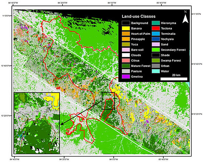
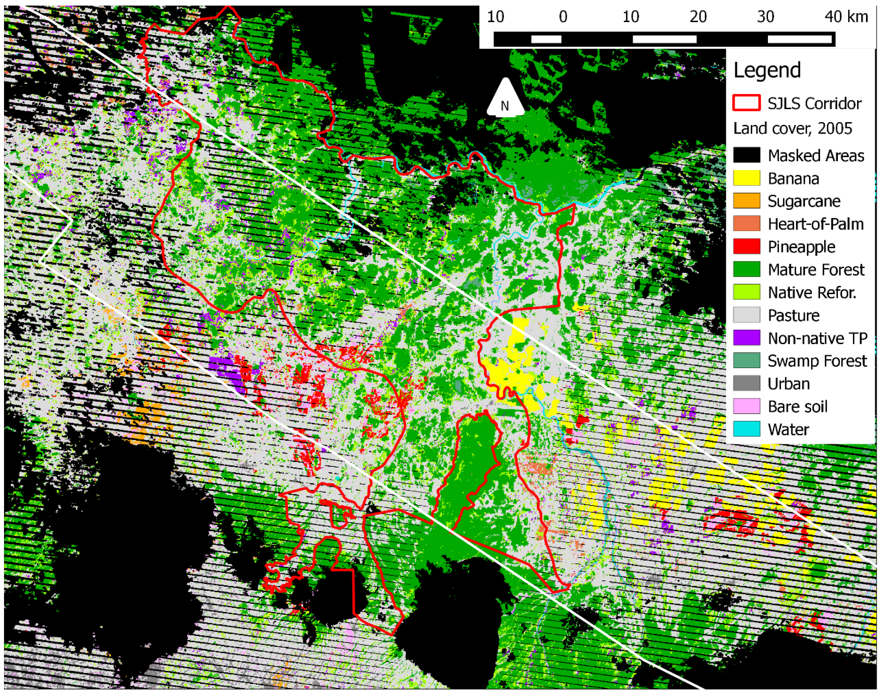
2.1. Study Area

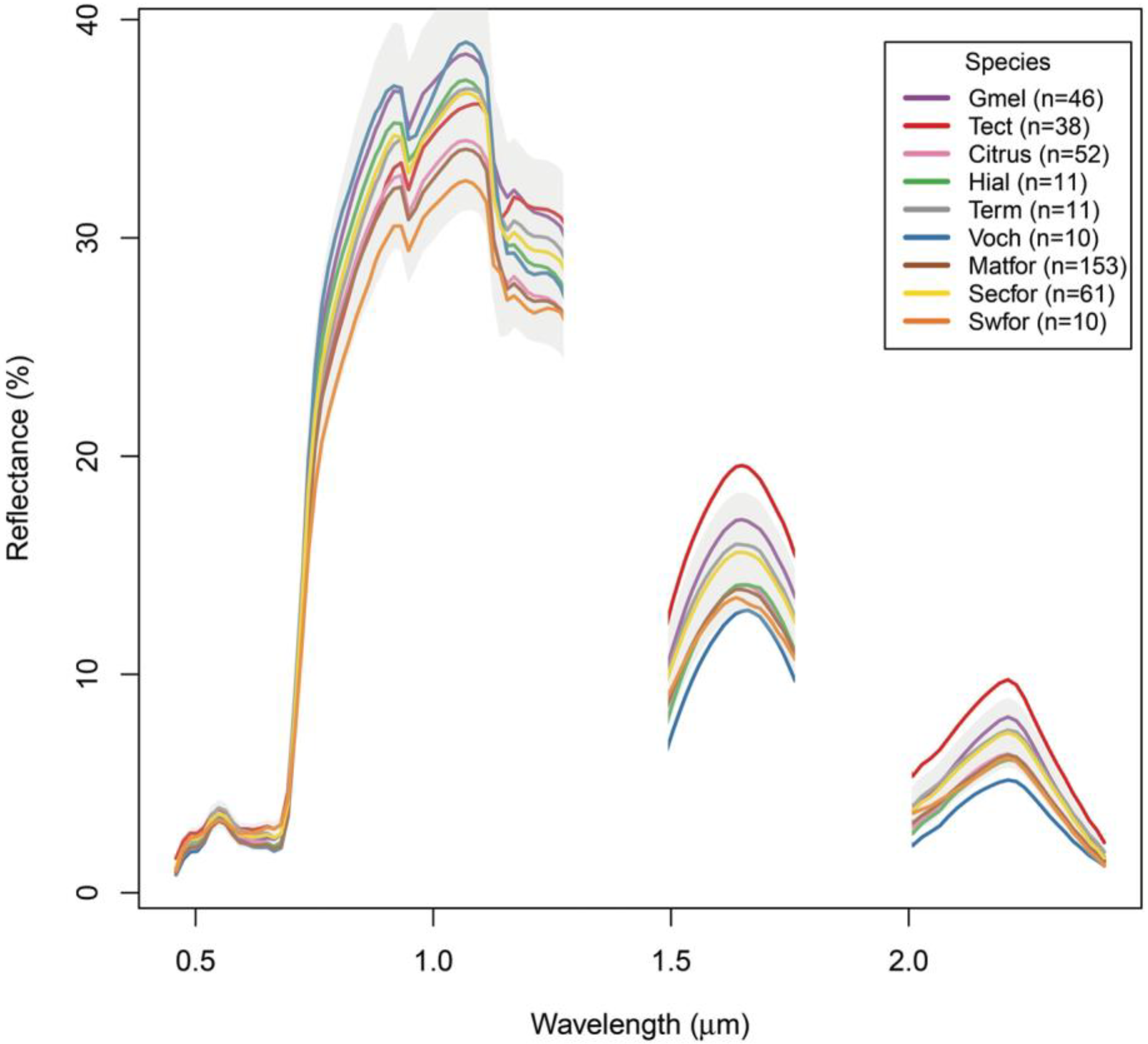
| Species | Uses [18] | Timber Harvest Rotation [89,90,91,92,93] | Canopy [89,90,91,92,93,94] * | Canopy Closure Rate [18,95,96] | Potential Understory Habitat [94] * | Management Issues [92,93, 96] * |
|---|---|---|---|---|---|---|
| Citrus spp. | Fruit | NA | Intermediate, with row-gaps | NA: row cultivation. | Grass | Intensively managed and cleared |
| Gmelina arborea | Timber | 3–15 years | Dense | High to Very High | Short, thin | Disease, herbicide when planting |
| Tectona grandis | Timber | 15–25 years | Dense to thin, semi-deciduous | Medium | Tall, dense | Fire or manual clearing of understory required. |
| Vochysia spp. (gu. and fer.) | Timber, habitat | 15–25+ years | Thin to intermediate | Medium to Medium-High | Tall, dense | N/A |
| Hieronyma alchorneoides | Timber, habitat | 25–40+ years | Thin to intermediate | Medium | Tall, dense | N/A |
| Terminalia spp. (am. and ivor.) | Timber, habitat | 25–40+ years | Very thin | Medium | Tall, dense | N/A |
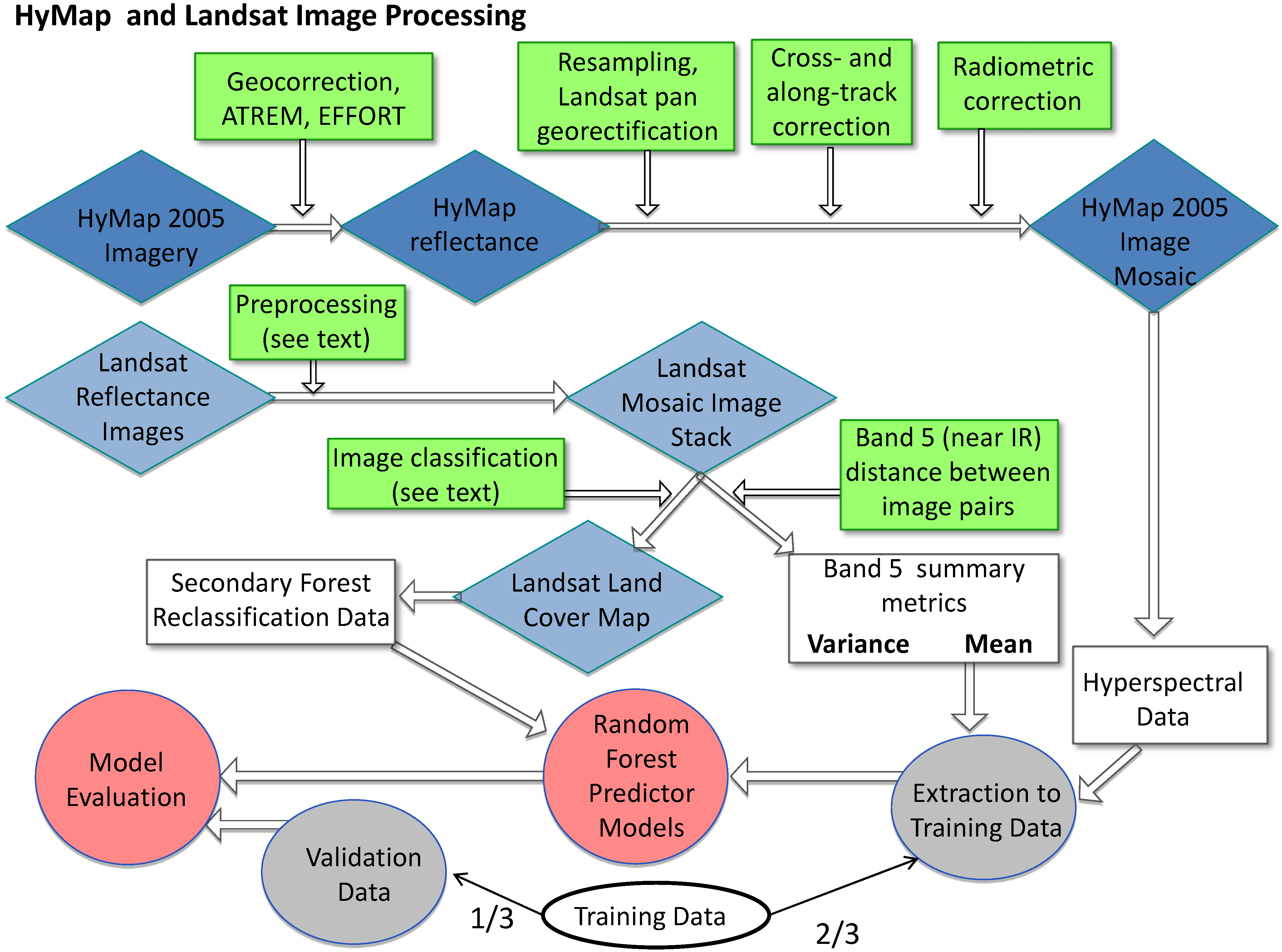
2.2. Remote Sensing Data


2.3. Field Data Collection
2.4. Forest Type Classification
2.4.1. Land Use Classes
| Summary Class | Classification Class | Short Name | Descriptions | Training Points | Training Pixels | Testing Points |
|---|---|---|---|---|---|---|
| Other | Banana | Banana | Large, export-oriented monocultures of banana | 54 | 1507 | 91 |
| Heart-of-Palm | Hpalm | Monocultures of heart-of-palm; occasional shade trees | 44 | 1220 | 81 | |
| Pineapple | Pina | Large, export-oriented monocultures of pineapple | 47 | 1302 | 86 | |
| Cassava | Cass. | Open monocultures of cassava | 15 | 417 | 68 | |
| Bare soil | Soil | Reddish exposed soil; mix of inceptisols and andisols | 28 | 772 | 112 | |
| Sand | Sand | Sandy soils, adjacent to river. | 23 | 909 | 74 | |
| Clouds | Cloud | Cumulus clouds. | 104 | 6342 | 67 | |
| Pasture | Past. | Open to wooded grassy pasture. | 180 | 4990 | 152 | |
| Shade | Shade | Cloud shadows and dark, deep water. | 100 | 4055 | 51 | |
| Urban | Urban | Mainly cement, asphault, and tin roofs. | 13 | 372 | 53 | |
| Water | Water | Open water. | 67 | 1212 | 99 | |
| Mature Forest | Lowland Mature Forest | Matfor | Forest >24 years old (Fagan et al. 2013). | 153 | 4259 | 119 |
| Swamp Forest | Swfor | Forest >24 years old that is dominated by Raphia palms. | 10 | 278 | 65 | |
| Secondary Forest | Secondary Forest | Secfor | Forest < 24 years old. | 61 | 1695 | 127 |
| Tree Plantations | Citrus | Citrus | Large orchards of Citrus spp. | 52 | 909 | 60 |
| Gmelina | Gmel. | Exotic tree plantations of Gmelina arborea. | 46 | 1105 | 80 | |
| Hieronyma | Hier. | Native tree plantations of Hieronyma alchorneoides. | 11 | 310 | 69 | |
| Tectona | Tect. | Exotic tree plantations of Tectona grandis. | 38 | 951 | 75 | |
| Terminalia | Term. | Native tree plantations of T. amazonia and the non-native T. ivorensis. | 11 | 305 | 61 | |
| Vochysia | Voch. | Native tree plantations of V. ferruginea and V. guatemalensis. | 10 | 253 | 43 |
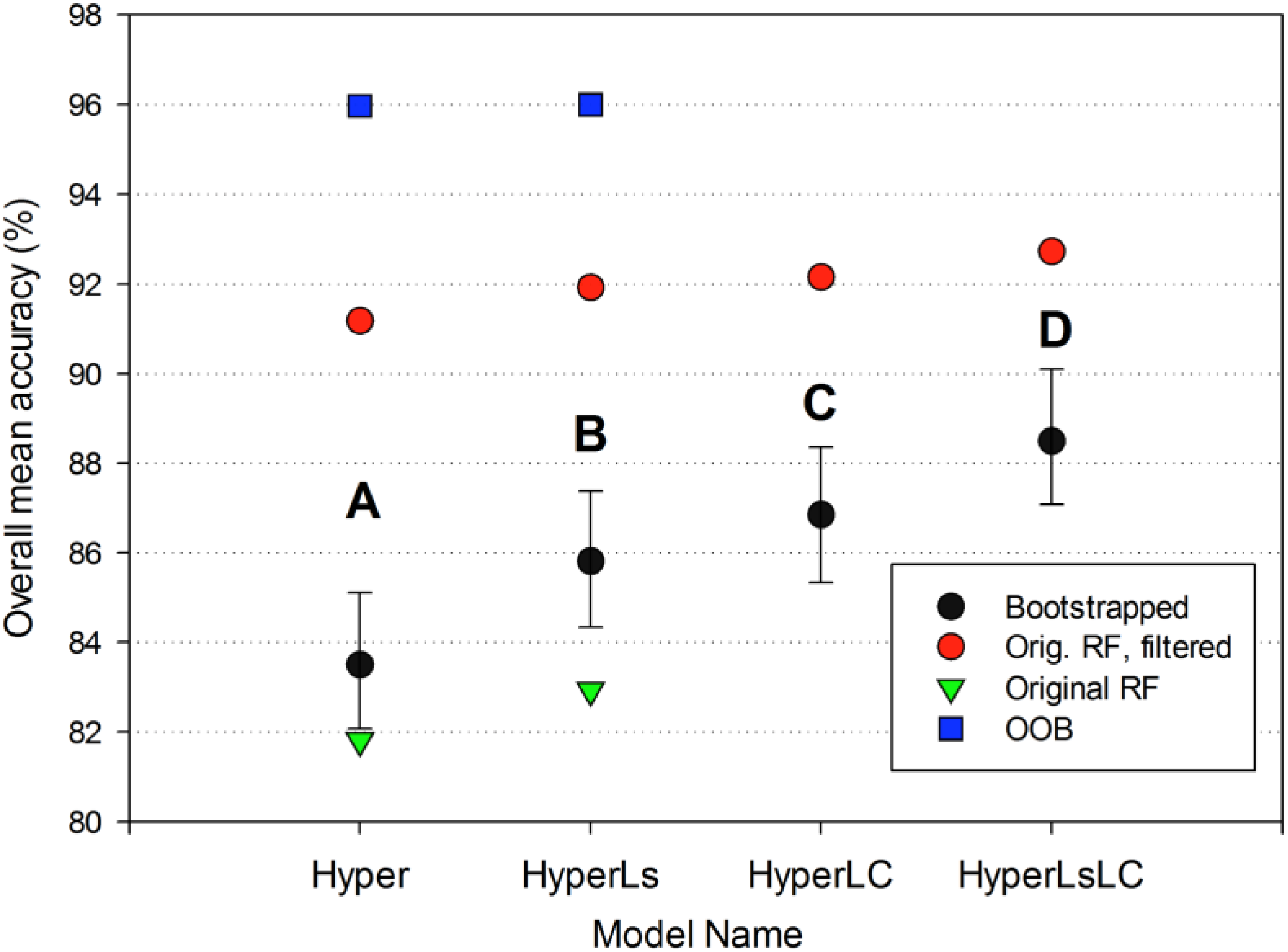
2.4.2. Classification Model Comparison
| Training Data | ||
|---|---|---|
| Imagery Data | Single Date | Multiple Dates |
| Hyperspectral | (1).Hyperspectral (Hyper) | NA |
| Hyperspectral + Landsat | (2).Hyper + Landsat spectral data (Ls) | (3).Hyper + Landsat land cover data (LC) Hyper + Ls + LC |

2.4.3. Post-Classification Processing
2.5. Accuracy Assessment
2.5.1. Independent Validation Data
2.5.2. Subsampling the Validation Data
3. Results and Discussion
3.1. Forest Type Classification


| Model: Hyper | Reference Data | |||||
|---|---|---|---|---|---|---|
| Predicted | Other | Mature Forest | Secondary Forest | Tree Plantations | Total | User Acc. |
| Other | 19,718 | 0 | 1272 | 605 | 21,595 | 91.6 |
| Mature Forest | 67 | 19,054 | 4533 | 1068 | 24,722 | 77.5 |
| Secondary Forest | 80 | 533 | 10,905 | 1200 | 12,718 | 86.2 |
| Tree Plantations | 135 | 413 | 3290 | 17,127 | 20,965 | 82.1 |
| Total | 20,000 | 20,000 | 20,000 | 20,000 | Overall: | |
| Prod. Acc. | 98.6 | 95.3 | 54.5 | 85.6 | 83.5 | |
| Model: HyperLsLC | Reference Data | |||||
| Predicted | Other | Mature Forest | Secondary Forest | Tree Plantations | Total | User Acc. |
| Other | 19,727 | 0 | 1150 | 688 | 21,426 | 91.8 |
| Mature Forest | 41 | 18,915 | 647 | 146 | 22,489 | 95.9 |
| Secondary Forest | 104 | 837 | 15,153 | 2158 | 14,558 | 83.5 |
| Tree Plantations | 128 | 248 | 3050 | 17,008 | 21,527 | 83.6 |
| Total | 20,000 | 20,000 | 20,000 | 20,000 | Overall: | |
| Prod. Acc. | 98.6 | 94.6 | 75.8 | 85.0 | 88.5 | |
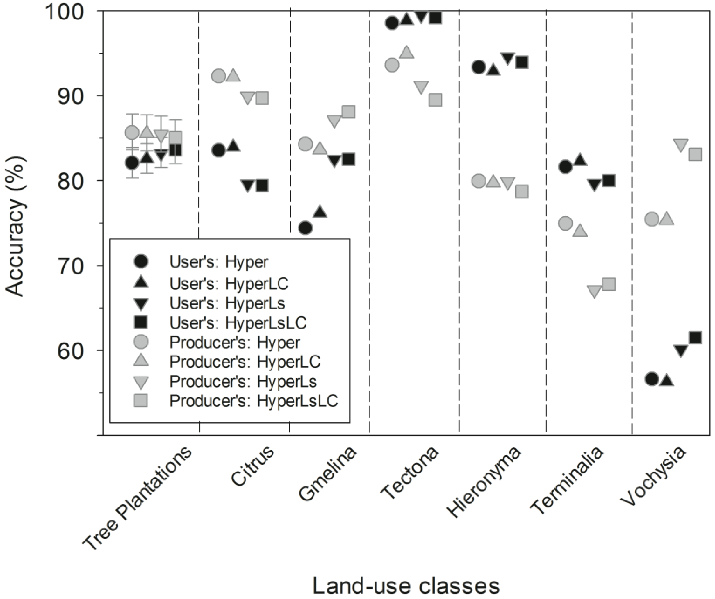
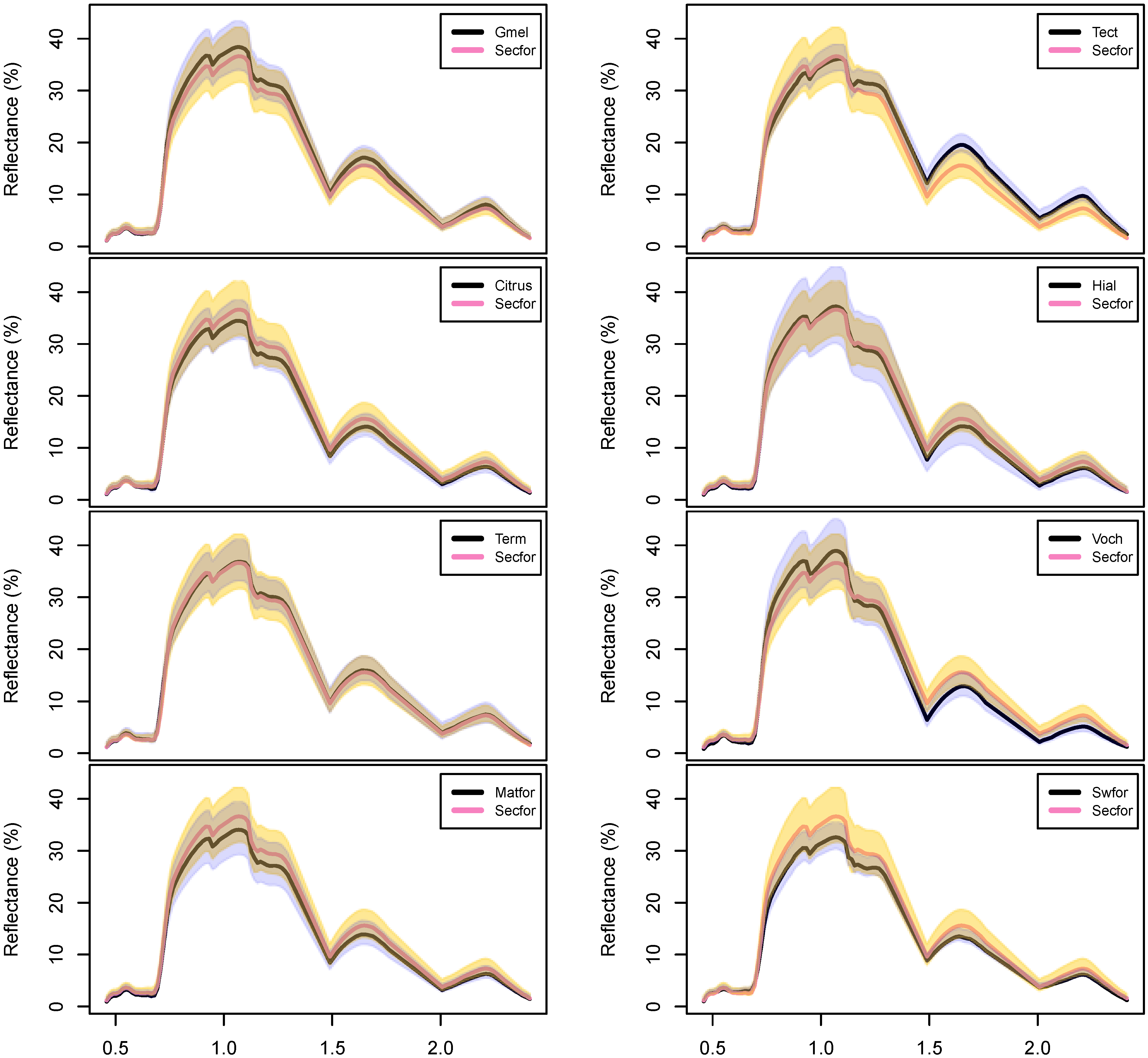
3.2. Tree Plantation Species Discrimination

| Reference Data | ||||||||||||
|---|---|---|---|---|---|---|---|---|---|---|---|---|
| Predicted | All Other | Mature Forest | Second. Forest | All TP spp. | Citrus | Gmelina | Hieronyma | Tectona | Terminalia | Vochysia | Total | User Acc. |
| All Other | 19,727 | 0 | 1150 | 688 | 232 | 191 | 47 | 164 | 54 | 0 | 21,565 | 91.8 |
| Mature Forest | 41 | 18,915 | 647 | 146 | 0 | 0 | 38 | 0 | 108 | 0 | 19,749 | 95.9 |
| Second. Forest | 104 | 837 | 15,153 | 2158 | 114 | 200 | 515 | 143 | 938 | 248 | 18,252 | 83.5 |
| All TP spp. | 128 | 248 | 3050 | 17,008 | 20,434 | 83.6 | ||||||
| Citrus | 12 | 0 | 640 | 3005 | 0 | 0 | 46 | 0 | 82 | 3785 | 79.4 | |
| Gmelina | 0 | 0 | 612 | 0 | 2893 | 0 | 0 | 0 | 0 | 3505 | 82.5 | |
| Hieronyma | 12 | 0 | 0 | 0 | 0 | 2585 | 0 | 0 | 157 | 2754 | 93.9 | |
| Tectona | 24 | 0 | 0 | 0 | 0 | 0 | 3009 | 0 | 0 | 3033 | 99.2 | |
| Terminalia | 46 | 0 | 464 | 0 | 0 | 0 | 0 | 2317 | 70 | 2897 | 80.0 | |
| Vochysia | 34 | 248 | 1334 | 0 | 0 | 100 | 0 | 0 | 2744 | 4460 | 61.5 | |
| Total | 200,000 | 20,000 | 20,000 | 20,000 | 3351 | 3284 | 3285 | 3362 | 3417 | 3301 | ||
| Prod. Acc. | 98.6 | 94.6 | 75.8 | 85.0 | 89.7 | 88.1 | 78.7 | 89.5 | 67.8 | 83.1 | ||

3.3. Hyperspectral Classification Accuracy
3.3.1. Classification of Tree Plantations

3.3.2. Classification of Other Forest Types
3.4. Hyperspectral and Multitemporal Data Classification Accuracy
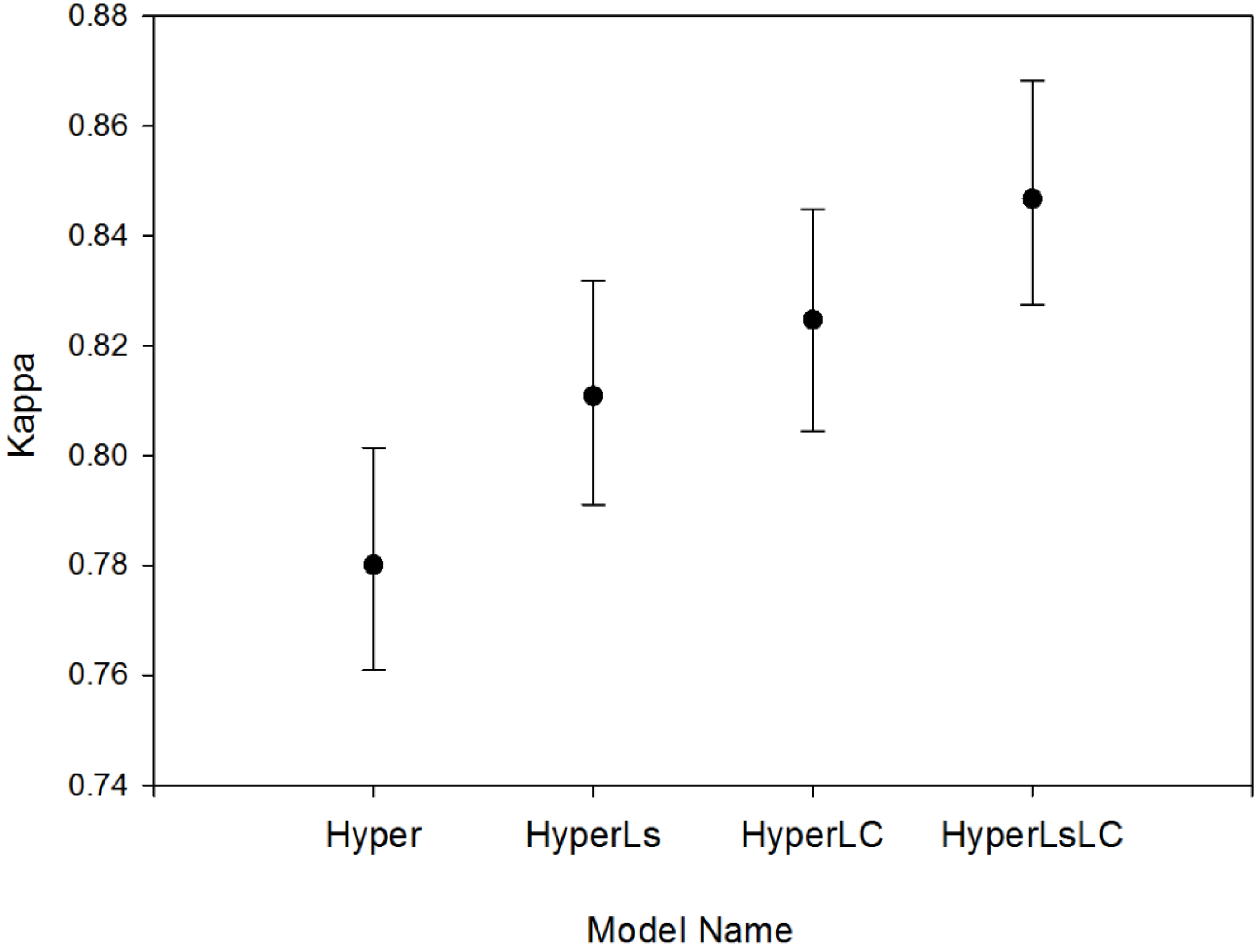
3.5. Model Accuracy Assessment
3.6. Status of Tree Plantations in Northeastern Costa Rica
4. Conclusions
Acknowledgments
Author Contributions
Appendix


| Image Type | Mosaic Year | Dates Used | Original Res. (m) | Reference Image |
|---|---|---|---|---|
| Landsat 5 | 1986/87 | 2/6/1986 | 30 | |
| 3/13/1987 | 30 | |||
| Landsat 5 | 1996/97 | 11/16/1996 | 30 | |
| 12/21/1997 | 30 | |||
| Landsat 5 | 2001 | 1/4/2001 | 30 | |
| Landsat 7 | 2005 | 2/2/2005 | 30 | ** |
| 9/30/2005 | 30 | |||
| HyMap | 2005 | 3/1/2005 | 15.4 | |
| 3/8/2005 | 14.2 | |||
| 3/10/2005 | 16.7 | ** | ||
| 3/17/2005 | 15.8 | |||
| 3/17/2005 | 16 | |||
| 3/25/2005 | 15 |
| Model: Hyper | Reference Data | |||||
|---|---|---|---|---|---|---|
| Predicted | Other | Mature Forest | Secondary Forest | Tree Plantations | Total | User Acc. |
| Other | 19,718 | 0 | 1272 | 605 | 21,595 | 91.6 |
| Mature Forest | 67 | 19,054 | 4533 | 1068 | 24,722 | 77.5 |
| Secondary Forest | 80 | 533 | 10,905 | 1200 | 12,718 | 86.2 |
| Tree Plantations | 135 | 413 | 3290 | 17,127 | 20,965 | 82.1 |
| Total | 20,000 | 20,000 | 20,000 | 20,000 | Overall: | |
| Prod. Acc. | 98.6 | 95.3 | 54.5 | 85.6 | 83.5 | |
| Model: HyperLs | Reference Data | |||||
| Predicted | Other | Mature Forest | Secondary Forest | Tree Plantations | Total | User Acc. |
| Other | 19,719 | 0 | 1046 | 663 | 21,428 | 92.3 |
| Mature Forest | 39 | 19,231 | 3161 | 517 | 22,948 | 84.2 |
| Secondary Forest | 123 | 521 | 12,621 | 1740 | 15,005 | 84.6 |
| Tree Plantations | 119 | 248 | 3172 | 17,080 | 20,619 | 83.2 |
| Total | 20,000 | 20,000 | 20,000 | 20,000 | Overall: | |
| Prod. Acc. | 98.6 | 96.2 | 63.1 | 85.4 | 85.8 | |
| Model: HyperLC | Reference Data | |||||
| Predicted | Other | Mature Forest | Secondary Forest | Tree Plantations | Total | User Acc. |
| Other | 19,724 | 0 | 1247 | 571 | 21,542 | 91.9 |
| Mature Forest | 52 | 18,745 | 1679 | 395 | 20,871 | 90.1 |
| Secondary Forest | 107 | 828 | 13,904 | 1926 | 16,765 | 83.5 |
| Tree Plantations | 117 | 427 | 3170 | 17,108 | 20,822 | 82.6 |
| Total | 20,000 | 20,000 | 20,000 | 20000 | Overall: | |
| Prod. Acc. | 98.6 | 93.7 | 69.5 | 85.5 | 86.9 | |
| Model: HyperLsLC | Reference Data | |||||
| Predicted | Other | Mature Forest | Secondary Forest | Tree Plantations | Total | User Acc. |
| Other | 19,727 | 0 | 1150 | 688 | 21,565 | 91.8 |
| Mature Forest | 41 | 18,915 | 647 | 146 | 19,749 | 95.9 |
| Secondary Forest | 104 | 837 | 15,153 | 2158 | 18,252 | 83.5 |
| Tree Plantations | 128 | 248 | 3050 | 17,008 | 20,434 | 83.6 |
| Total | 20,000 | 20,000 | 20,000 | 20,000 | Overall: | |
| Prod. Acc. | 98.6 | 94.6 | 75.8 | 85.0 | 88.5 | |
| Banana | Hpalm | Pina | Cass. | Soil | Sand | Cloud | Past. | Shade | Urban | Water | |
|---|---|---|---|---|---|---|---|---|---|---|---|
| Banana | 1685 | 0 | 0 | 0 | 19 | 0 | 0 | 0 | 0 | 0 | 0 |
| Hpalm | 0 | 1780 | 0 | 30 | 0 | 0 | 0 | 11 | 0 | 0 | 0 |
| Pina | 0 | 0 | 1795 | 29 | 17 | 0 | 25 | 0 | 0 | 0 | 0 |
| Cass. | 0 | 0 | 0 | 1578 | 13 | 0 | 26 | 15 | 0 | 0 | 0 |
| Soil | 0 | 0 | 0 | 25 | 1118 | 23 | 66 | 9 | 0 | 0 | 0 |
| Sand | 0 | 0 | 0 | 0 | 290 | 1594 | 0 | 0 | 0 | 68 | 20 |
| Cloud | 0 | 0 | 20 | 27 | 76 | 25 | 1518 | 0 | 0 | 104 | 39 |
| Past. | 15 | 0 | 17 | 101 | 96 | 31 | 47 | 1600 | 0 | 99 | 38 |
| Shade | 0 | 0 | 38 | 37 | 11 | 0 | 55 | 41 | 1957 | 40 | 134 |
| Urban | 0 | 0 | 0 | 0 | 135 | 154 | 0 | 0 | 0 | 1481 | 26 |
| Water | 0 | 0 | 0 | 0 | 9 | 0 | 0 | 0 | 0 | 0 | 1520 |
| Matfor | 0 | 0 | 0 | 0 | 0 | 0 | 33 | 8 | 0 | 0 | 0 |
| Swfor | 0 | 0 | 0 | 0 | 0 | 0 | 0 | 0 | 0 | 0 | 0 |
| Secfor | 17 | 17 | 0 | 0 | 0 | 0 | 0 | 52 | 0 | 0 | 18 |
| Citrus | 0 | 0 | 0 | 0 | 0 | 0 | 0 | 12 | 0 | 0 | 0 |
| Gmel. | 0 | 0 | 0 | 0 | 0 | 0 | 0 | 0 | 0 | 0 | 0 |
| Hier. | 0 | 0 | 0 | 0 | 0 | 0 | 0 | 12 | 0 | 0 | 0 |
| Tect. | 0 | 0 | 0 | 0 | 0 | 0 | 0 | 24 | 0 | 0 | 0 |
| Term. | 0 | 0 | 0 | 0 | 0 | 0 | 32 | 14 | 0 | 0 | 0 |
| Voch. | 14 | 20 | 0 | 0 | 0 | 0 | 0 | 0 | 0 | 0 | 0 |
| Total | 1731 | 1817 | 1870 | 1827 | 1784 | 1827 | 1802 | 1798 | 1957 | 1792 | 1795 |
| Prod. Acc. | 97.3 | 98.0 | 96.0 | 86.4 | 62.7 | 87.2 | 84.2 | 89.0 | 100.0 | 82.6 | 84.7 |
| Banana | Matfor | Swfor | Secfor | Citrus | Gmel. | Hier. | Tect. | Term. | Voch. | Total | User Acc. |
| Banana | 0 | 0 | 0 | 0 | 0 | 0 | 0 | 0 | 0 | 1704 | 98.9 |
| Hpalm | 0 | 0 | 295 | 0 | 88 | 0 | 114 | 0 | 0 | 2318 | 76.8 |
| Pina | 0 | 0 | 0 | 0 | 0 | 0 | 0 | 0 | 0 | 1866 | 96.2 |
| Cass. | 0 | 0 | 0 | 0 | 0 | 0 | 0 | 0 | 0 | 1632 | 96.7 |
| Soil | 0 | 0 | 0 | 0 | 0 | 0 | 0 | 0 | 0 | 1241 | 90.1 |
| Sand | 0 | 0 | 0 | 0 | 0 | 0 | 0 | 0 | 0 | 1972 | 80.8 |
| Cloud | 0 | 0 | 0 | 65 | 32 | 0 | 0 | 0 | 0 | 1906 | 79.6 |
| Past. | 0 | 0 | 701 | 167 | 71 | 47 | 50 | 54 | 0 | 3134 | 51.1 |
| Shade | 0 | 0 | 154 | 0 | 0 | 0 | 0 | 0 | 0 | 2467 | 79.3 |
| Urban | 0 | 0 | 0 | 0 | 0 | 0 | 0 | 0 | 0 | 1796 | 82.5 |
| Water | 0 | 0 | 0 | 0 | 0 | 0 | 0 | 0 | 0 | 1529 | 99.4 |
| Matfor | 9062 | 608 | 647 | 0 | 0 | 38 | 0 | 108 | 0 | 10504 | 86.3 |
| Swfor | 0 | 9245 | 0 | 0 | 0 | 0 | 0 | 0 | 0 | 9245 | 100.0 |
| Secfor | 698 | 139 | 15153 | 114 | 200 | 515 | 143 | 938 | 248 | 18252 | 83.0 |
| Citrus | 0 | 0 | 640 | 3005 | 0 | 0 | 46 | 0 | 82 | 3785 | 79.4 |
| Gmel. | 0 | 0 | 612 | 0 | 2893 | 0 | 0 | 0 | 0 | 3505 | 82.5 |
| Hier. | 0 | 0 | 0 | 0 | 0 | 2585 | 0 | 0 | 157 | 2754 | 93.9 |
| Tect. | 0 | 0 | 0 | 0 | 0 | 0 | 3009 | 0 | 0 | 3033 | 99.2 |
| Term. | 0 | 0 | 464 | 0 | 0 | 0 | 0 | 2317 | 70 | 2897 | 80.0 |
| Voch. | 248 | 0 | 1334 | 0 | 0 | 100 | 0 | 0 | 2744 | 4460 | 61.5 |
| Total | 10008 | 9992 | 20000 | 3351 | 3284 | 3285 | 3362 | 3417 | 3301 | ||
| Prod. Acc. | 90.5 | 92.5 | 75.8 | 89.7 | 88.1 | 78.7 | 89.5 | 67.8 | 83.1 |
Conflicts of Interest
References
- FAO. Global Forest Resources Assessment 2010; Food and Agriculture Organization of the United Nations: Rome, Italy, 2010. [Google Scholar]
- Koh, L.P.; Wilcove, D.S. Is oil palm agriculture really destroying tropical biodiversity? Conserv. Lett. 2008, 1, 60–64. [Google Scholar] [CrossRef]
- Sterling, S.; Ducharne, A. Comprehensive data set of global land cover change for land surface model applications. Glob. Biogeochem. Cy. 2008, 22. [Google Scholar] [CrossRef]
- Grainger, A. Difficulties in tracking the long-term global trend in tropical forest area. Proc. Natl. Acad. Sci. USA 2008, 105, 818–823. [Google Scholar] [CrossRef] [PubMed]
- Puyravaud, J.-P.; Davidar, P.; Laurance, W.F. Cryptic destruction of India’s native forests. Conserv. Lett. 2010, 3, 390–394. [Google Scholar] [CrossRef]
- Caccetta, P.; Furby, S.; Wallace, J. Long-term monitoring of australian land cover change using landsat data: Development, implementation, and operation. In Global Forest Monitoring from Earth Observation; Achard, F., Hansen, M.C., Eds.; CRC Press: Boca Raton, FL, USA, 2012; pp. 243–258. [Google Scholar]
- Hansen, M.C.; Loveland, T.R. A review of large area monitoring of land cover change using Landsat data. Remote Sens. Environ. 2012, 122, 66–74. [Google Scholar] [CrossRef]
- Sánchez-Azofeifa, G.A.; Castro-Esau, K.L.; Kurz, W.A.; Joyce, A. Monitoring carbon stocks in the tropics and the remote sensing operational limitations: From local to regional projects. Ecol. Appl. 2009, 19, 480–494. [Google Scholar] [CrossRef] [PubMed]
- Fagan, M.E.; DeFries, R.S.; Sesnie, S.E.; Arroyo, J.P.; Walker, W.; Soto, C.; Chazdon, R.L.; Sanchun, A. Land cover dynamics following a deforestation ban in northern Costa Rica. Environ. Res. Lett. 2013, 8, 034017. [Google Scholar] [CrossRef]
- Miettinen, J.; Shi, C.; Tan, W.J.; Liew, S.C. 2010 land cover map of insular Southeast Asia in 250-m spatial resolution. Remote Sens. Lett. 2012, 3, 11–20. [Google Scholar] [CrossRef]
- Potapov, P.V.; Turubanova, S.A.; Hansen, M.C.; Adusei, B.; Broich, M.; Altstatt, A.; Mane, L.; Justice, C.O. Quantifying forest cover loss in Democratic Republic of the Congo, 2000–2010, with Landsat ETM+ data. Remote Sens. Environ. 2012, 122, 106–116. [Google Scholar] [CrossRef]
- Hansen, M.C.; Potapov, P.V.; Moore, R.; Hancher, M.; Turubanova, S.A.; Tyukavina, A.; Thau, D.; Stehman, S. V.; Goetz, S.J.; Loveland, T.R.; et al. High-resolution global maps of 21st-century forest cover change. Science 2013, 342, 850–853. [Google Scholar] [CrossRef]
- Tropek, R.; Sedláček, O.; Beck, J.; Keil, P.; Musilová, Z.; Šímová, I.; Storch, D. Comment on “High-resolution global maps of 21st-century forest cover change.”. Science 2014, 344. [Google Scholar] [CrossRef]
- Putz, F.E.; Redford, K.H. The Importance of Defining “Forest”: Tropical Forest Degradation, Deforestation, Long-term Phase Shifts, and Further Transitions. Biotropica 2010, 42, 10–20. [Google Scholar] [CrossRef]
- Brockerhoff, E.G.; Jactel, H.; Parrotta, J.A.; Quine, C.P.; Sayer, J. Plantation forests and biodiversity: Oxymoron or opportunity? Biodivers. Conserv. 2008, 17, 925–951. [Google Scholar] [CrossRef]
- De Blécourt, M.; Brumme, R.; Xu, J.; Corre, M.D.; Veldkamp, E. Soil carbon stocks decrease following conversion of secondary forests to rubber (Hevea brasiliensis) plantations. PLoS ONE 2013, 8, e69357. [Google Scholar] [CrossRef]
- Mandle, L.; Bufford, J.L.; Schmidt, I.B.; Daehler, C.C. Woody exotic plant invasions and fire: Reciprocal impacts and consequences for native ecosystems. Biol. Invasions 2011, 13, 1815–1827. [Google Scholar] [CrossRef]
- Redondo-Brenes, A. Growth, carbon sequestration, and management of native tree plantations in humid regions of Costa Rica. New For. 2007, 34, 253–268. [Google Scholar] [CrossRef]
- Fonseca, C.R.; Ganade, G.; Baldissera, R.; Becker, C.G.; Boelter, C.R.; Brescovit, A.D.; Campos, L.M.; Fleck, T.; Fonseca, V.S.; Hartz, S.M.; et al. Towards an ecologically-sustainable forestry in the Atlantic Forest. Biol. Conserv. 2009, 142, 1209–1219. [Google Scholar] [CrossRef]
- Nájera, A.; Simonetti, J.A. Enhancing Avifauna in Commercial Plantations. Conserv. Biol. 2010, 24, 319–324. [Google Scholar] [CrossRef] [PubMed]
- Carnus, J.; Parrotta, J.; Brockerhoff, E. Planted forests and biodiversity. J. For. 2006, 104, 65–77. [Google Scholar]
- Barlow, J.; Gardner, T.A.; Araujo, I.S.; Avila-Pires, T.C.; Bonaldo, A.B.; Costa, J.E.; Esposito, M.C.; Ferreira, L.V.; Hawes, J.; Hernandez, M.M.I.M.; et al. Quantifying the biodiversity value of tropical primary, secondary, and plantation forests. Proc. Natl. Acad. Sci. USA 2007, 104, 18555–18560. [Google Scholar] [CrossRef]
- Aratrakorn, S.; Thunhikorn, S.; Donald, P.F. Changes in bird communities following conversion of lowland forest to oil palm and rubber plantations in southern Thailand. Bird Conserv. Int. 2006, 16, 71–82. [Google Scholar] [CrossRef]
- UN-REDD. UN-REDD Programme Partner Countries. Available online: http://www.un-redd.org/Partner_Countries/tabid/102663/Default.aspx (accessed on 9 November 2013).
- Morse, W.C.; Schedlbauer, J.L.; Sesnie, S.E.; Finegan, B.; Harvey, C.A.; Hollenhorst, S.J.; Kavanagh, K.L.; Stoian, D.; Wulfhorst, J.D. Consequences of environmental service payments for forest retention and recruitment in a costa rican biological corridor. Ecol. Soc. 2009, 14, 23. [Google Scholar]
- Daniels, A.E. Forest expansion in Northwest Costa Rica: Conjuncture of the global market, land-use intensification, and forest protection. In Reforesting Landscapes: Linking Pattern and Process; Nagendra, H., Southworth, J., Eds.; Landscape Series; Springer Netherlands: Dordrecht, The Netherlands, 2010; Volume 10, pp. 227–252. [Google Scholar]
- Arroyo-Mora, J.P.; Sánchez-Azofeifa, G.A.; Rivard, B.; Calvo, J.C.; Janzen, D.H. Dynamics in landscape structure and composition for the Chorotega region, Costa Rica from 1960 to 2000. Agric. Ecosyst. Environ. 2005, 106, 27–39. [Google Scholar] [CrossRef]
- Sánchez-Azofeifa, G.A.; Daily, G.C.; Pfaff, A.S.P.; Busch, C. Integrity and isolation of Costa Rica’s national parks and biological reserves: Examining the dynamics of land-cover change. Biol. Conserv. 2003, 109, 123–135. [Google Scholar] [CrossRef]
- Schelhas, J.; Sánchez-Azofeifa, G.A. Post-frontier forest change adjacent to Braulio Carrillo National Park, Costa Rica. Hum. Ecol. 2006, 34, 407–431. [Google Scholar] [CrossRef]
- Read, J.; Denslow, J.; Guzman, S. Documenting land cover history of a humid tropical environment in northeastern Costa Rica using time-series remotely sensed data. In GIS and Remote Sensing Applications in Biogeography; Millington, A.C., Walsh, S.J., Osborne, P.E., Eds.; Kluwer Academic Publishers: Boston, MA, USA, 2001; pp. 69–89. [Google Scholar]
- Anonymous. LA GACETA N° 15 DEL 20 DE ENERO DEL 2012; Gobierno de la República de Costa Rica: San José, Costa Rica, 2012. [Google Scholar]
- Daniels, A.E.; Bagstad, K.; Esposito, V.; Moulaert, A.; Rodriguez, C.M. Understanding the impacts of Costa Rica’s PES: Are we asking the right questions? Ecol. Econ. 2010, 69, 2116–2126. [Google Scholar] [CrossRef]
- De Camino, R.; Segura, O.; Arias, L.G.; Pérez, I. Costa Rica: Forest Strategy and the Evolution of Land Use; World Bank Publications: Washington, DC, USA, 2000. [Google Scholar]
- Sánchez-Azofeifa, G.A.; Pfaff, A.; Robalino, J.A.; Boomhower, J.P. Costa Rica’s payment for environmental services program: Intention, implementation, and impact. Conserv. Biol. 2007, 21, 1165–1173. [Google Scholar] [CrossRef]
- Robalino, J.; Pfaff, A. Ecopayments and deforestation in Costa Rica: A nationwide analysis of PSA’s initial years. Land Econ. 2013, 89, 432–448. [Google Scholar]
- Sanchez-Azofeifa, G.A.; Harriss, R.C.; Skole, D.L. Deforestation in Costa Rica: A quantitative analysis using remote sensing imagery. Biotropica 2001, 33, 378–384. [Google Scholar] [CrossRef]
- Sesnie, S.E.; Gessler, P.E.; Finegan, B.; Thessler, S. Integrating Landsat TM and SRTM-DEM derived variables with decision trees for habitat classification and change detection in complex neotropical environments. Remote Sens. Environ. 2008, 112, 2145–2159. [Google Scholar] [CrossRef]
- Chassot, O. Diseño de un Paisaje Funcional de Conservación Para el Caribe Norte de Costa Rica; Universidad Nacional de Costa Rica: San José, Costa Rica, 2010; p. 164. [Google Scholar]
- Feret, J.; Asner, G.P. Tree species discrimination in tropical forests using airborne imaging spectroscopy. IEEE Trans. Geosci. Remote Sens. 2013, 51, 73–84. [Google Scholar] [CrossRef]
- Ghiyamat, A.; Shafri, H. A review on hyperspectral remote sensing for homogeneous and heterogeneous forest biodiversity assessment. Int. J. Remote Sens. 2010, 31, 1837–1856. [Google Scholar] [CrossRef] [Green Version]
- Nagendra, H.; Lucas, R.; Honrado, J.P.; Jongman, R.H.G.; Tarantino, C.; Adamo, M.; Mairota, P. Remote sensing for conservation monitoring: Assessing protected areas, habitat extent, habitat condition, species diversity, and threats. Ecol. Indic. 2013, 33, 45–59. [Google Scholar] [CrossRef]
- Schimel, D.S.; Asner, G.P.; Moorcroft, P. Observing changing ecological diversity in the Anthropocene. Front. Ecol. Environ. 2013, 11, 129–137. [Google Scholar] [CrossRef]
- Clark, M.L.; Roberts, D.A.; Clark, D.B. Hyperspectral discrimination of tropical rain forest tree species at leaf to crown scales. Remote Sens. Environ. 2005, 96, 375–398. [Google Scholar] [CrossRef]
- Zhang, J.K.; Rivard, B.; Sanchez-Azofeifa, A.; Castro-Esau, K.; Sánchez-Azofeifa, A. Intra and inter-class spectral variability of tropical tree species at La Selva, Costa Rica: Implications for species identification using HYDICE imagery. Remote Sens. Environ. 2006, 105, 129–141. [Google Scholar] [CrossRef]
- Naidoo, L.; Cho, M.A.A.; Mathieu, R.; Asner, G. Classification of savanna tree species, in the Greater Kruger National Park region, by integrating hyperspectral and LiDAR data in a Random Forest data mining environment. ISPRS J. Photogramm. Remote Sens. 2012, 69, 167–179. [Google Scholar] [CrossRef]
- Colgan, M.; Baldeck, C.; Féret, J.-B.; Asner, G. Mapping savanna tree species at ecosystem scales using support vector machine classification and BRDF correction on airborne hyperspectral and LiDAR data. Remote Sens. 2012, 4, 3462–3480. [Google Scholar] [CrossRef]
- Cho, M.A.; Mathieu, R.; Asner, G.P.; Naidoo, L.; van Aardt, J.; Ramoelo, A.; Debba, P.; Wessels, K.; Main, R.; Smit, I.P.J.; et al. Mapping tree species composition in South African savannas using an integrated airborne spectral and LiDAR system. Remote Sens. Environ. 2012, 125, 214–226. [Google Scholar] [CrossRef]
- Papeş, M.; Tupayachi, R.; Martínez, P.; Peterson, A.T.T.; Powell, G.V.N. Using hyperspectral satellite imagery for regional inventories: A test with tropical emergent trees in the Amazon Basin. J. Veg. Sci. 2010, 21, 342–354. [Google Scholar] [CrossRef]
- Somers, B.; Asner, G.P. Hyperspectral time series analysis of native and invasive species in Hawaiian Rainforests. Remote Sens. 2012, 4, 2510–2529. [Google Scholar] [CrossRef]
- Vyas, D.; Krishnayya, N.S.R.; Manjunath, K.R.; Ray, S.S.; Panigrahy, S. Evaluation of classifiers for processing Hyperion (EO-1) data of tropical vegetation. Int. J. Appl. Earth Obs. Geoinf. 2011, 13, 228–235. [Google Scholar] [CrossRef]
- Koedsin, W.; Vaiphasa, C. Discrimination of tropical mangroves at the species level with EO-1 hyperion data. Remote Sens. 2013, 5, 3562–3582. [Google Scholar] [CrossRef]
- Van Aardt, J.A.N.; Norris-Rogers, M. Spectral-age interactions in managed, even-aged Eucalyptus plantations: Application of discriminant analysis and classification and regression trees approaches to hyperspectral data. Int. J. Remote Sens. 2008, 29, 1841–1845. [Google Scholar] [CrossRef]
- Peerbhay, K.Y.; Mutanga, O.; Ismail, R. Commercial tree species discrimination using airborne AISA Eagle hyperspectral imagery and partial least squares discriminant analysis (PLS-DA) in KwaZulu–Natal, South Africa. ISPRS J. Photogramm. Remote Sens. 2013, 79, 19–28. [Google Scholar] [CrossRef]
- Thenkabail, P.S.; Enclona, E.A.; Ashton, M.S.; Legg, C.; de Dieu, M.J. Hyperion, IKONOS, ALI, and ETM plus sensors in the study of African rainforests. Remote Sens. Environ. 2004, 90, 23–43. [Google Scholar] [CrossRef]
- Galvão, L.S.; Ponzoni, F.J.; Liesenberg, V.; Santos, J.R. Dos Possibilities of discriminating tropical secondary succession in Amazônia using hyperspectral and multiangular CHRIS/PROBA data. Int. J. Appl. Earth Obs. Geoinf. 2009, 11, 8–14. [Google Scholar] [CrossRef]
- Kalacska, M.; Sanchez-Azofeifa, G.A.; Rivard, B.; Caelli, T.; White, H.P.; Calvo-Alvarado, J.C. Ecological fingerprinting of ecosystem succession: Estimating secondary tropical dry forest structure and diversity using imaging spectroscopy. Remote Sens. Environ. 2007, 108, 82–96. [Google Scholar] [CrossRef]
- Sims, N.C.; Culvenor, D.; Newnham, G.; Coops, N.C.; Hopmans, P. Towards the operational use of satellite hyperspectral image data for mapping nutrient status and fertilizer requirements in Australian Plantation Forests. IEEE J. Sel. Top. Appl. Earth Obs. Remote Sens. 2013, 6, 320–328. [Google Scholar] [CrossRef]
- Somers, B.; Verbesselt, J.; Ampe, E.M.; Sims, N.; Verstraeten, W.W.; Coppin, P. Spectral mixture analysis to monitor defoliation in mixed-aged Eucalyptus globulus Labill plantations in southern Australia using Landsat 5-TM and EO-1 Hyperion data. Int. J. Appl. Earth Obs. Geoinf. 2010, 12, 270–277. [Google Scholar] [CrossRef]
- Cho, M.A.; van Aardt, J.; Main, R.; Majeke, B. Evaluating variations of physiology-based hyperspectral features along a soil water gradient in a Eucalyptus grandis plantation. Int. J. Remote Sens. 2010, 31, 3143–3159. [Google Scholar] [CrossRef]
- Kuplich, T.M.; Freitas, C.C.; Soares, J.V. The study of ERS-1 SAR and Landsat TM synergism for land use classification. Int. J. Remote Sens. 2000, 21, 2101–2111. [Google Scholar] [CrossRef]
- Nagendra, H.; Gadgil, M. Satellite imagery as a tool for monitoring species diversity: An assessment. J. Appl. Ecol. 1999, 36, 388–397. [Google Scholar] [CrossRef]
- Sugumaran, R.; Sandhya, G.; Rao, K.S.; Jadhav, R.N.; Kimothi, M.M. Delineation of social forestry plantations under various afforestation programmes using satellite digital data. J. Indian Soc. Remote Sens. 1994, 22, 245–249. [Google Scholar] [CrossRef]
- Echeverria, C.; Coomes, D.; Salas, J.; Rey-Benayas, J.M.; Lara, A.; Newton, A. Rapid deforestation and fragmentation of Chilean Temperate Forests. Biol. Conserv. 2006, 130, 481–494. [Google Scholar] [CrossRef]
- Clark, B.; Pellikka, P. Landscape analysis using multi-scale segmentation and objectoriented classification. In Recent Advances in Remote Sensing and Geoinformation Processing for Land Degradation Assessment; Hill, Roder, Eds.; Taylor & Francis: London, UK, 2009; pp. 323–341. [Google Scholar]
- Pellikka, P.K.E.; Lötjönen, M.; Siljander, M.; Lens, L. Airborne remote sensing of spatiotemporal change (1955–2004) in indigenous and exotic forest cover in the Taita Hills, Kenya. Int. J. Appl. Earth Obs. Geoinf. 2009, 11, 221–232. [Google Scholar] [CrossRef]
- Wasige, J.E.; Groen, T.A.; Smaling, E.; Jetten, V. Monitoring basin-scale land cover changes in Kagera Basin of Lake Victoria using ancillary data and remote sensing. Int. J. Appl. Earth Obs. Geoinf. 2013, 21, 32–42. [Google Scholar] [CrossRef]
- Sesnie, S.E.; Finegan, B.; Gessler, P.E.; Thessler, S.; Bendana, Z.R.; Smith, A.M.S. The multispectral separability of Costa Rican rainforest types with support vector machines and Random Forest decision trees. Int. J. Remote Sens. 2010, 31, 2885–2909. [Google Scholar] [CrossRef]
- Muñoz-Villers, L.E.; López-Blanco, J. Land use/cover changes using Landsat TM/ETM images in a tropical and biodiverse mountainous area of central-eastern Mexico. Int. J. Remote Sens. 2008, 29, 71–93. [Google Scholar] [CrossRef]
- Ortega-Huerta, M.A.; Komar, O.; Price, K.P.; Ventura, H.J. Mapping coffee plantations with Landsat imagery: An example from El Salvador. Int. J. Remote Sens. 2012, 33, 220–242. [Google Scholar] [CrossRef]
- Koh, L.P.; Miettinen, J.; Liew, S.C.; Ghazoul, J. Remotely sensed evidence of tropical peatland conversion to oil palm. Proc. Natl. Acad. Sci. USA 2011, 108, 5127–5132. [Google Scholar] [CrossRef] [PubMed]
- Gutiérrez-Vélez, V.H.; DeFries, R. Annual multi-resolution detection of land cover conversion to oil palm in the Peruvian Amazon. Remote Sens. Environ. 2013, 129, 154–167. [Google Scholar] [CrossRef]
- Morel, A.C.; Fisher, J.B.; Malhi, Y. Evaluating the potential to monitor aboveground biomass in forest and oil palm in Sabah, Malaysia, for 2000–2008 with Landsat ETM+ and ALOS-PALSAR. Int. J. Remote Sens. 2012, 33, 3614–3639. [Google Scholar] [CrossRef]
- Carlson, K.M.; Curran, L.M.; Ratnasari, D.; Pittman, A.M.; Soares-Filho, B.S.; Asner, G.P.; Trigg, S.N.; Gaveau, D.A.; Lawrence, D.; Rodrigues, H.O. Committed carbon emissions, deforestation, and community land conversion from oil palm plantation expansion in West Kalimantan, Indonesia. Proc. Natl. Acad. Sci. USA 2012, 109, 7559–7564. [Google Scholar] [CrossRef] [PubMed]
- Baban, S.M.J.; Yusof, K.W. Mapping land use/cover distribution on a mountainous tropical island using remote sensing and GIS. Int. J. Remote Sens. 2001, 22, 1909–1918. [Google Scholar] [CrossRef]
- Senf, C.; Pflugmacher, D.; van der Linden, S.; Hostert, P. Mapping rubber plantations and natural forests in Xishuangbanna (Southwest China) using multi-spectral phenological metrics from MODIS Time Series. Remote Sens. 2013, 5, 2795–2812. [Google Scholar] [CrossRef]
- Asner, G.P.; Jones, M.O.; Martin, R.E.; Knapp, D.E.; Hughes, R.F. Remote sensing of native and invasive species in Hawaiian forests. Remote Sens. Environ. 2008, 112, 1912–1926. [Google Scholar] [CrossRef]
- Fagan, M.E.; DeFries, R.S. Measurement and Monitoring of the World’s Forests: A Review and Summary of Technical Capability, 2009–2015; Resources for the Future (RFF): Washington, DC, USA, 2009; p. 70. [Google Scholar]
- Helmer, E.H.; Lefsky, M.A.; Roberts, D.A. Biomass accumulation rates of Amazonian secondary forest and biomass of old-growth forests from Landsat time series and the Geoscience Laser Altimeter System. J. Appl. Remote Sens. 2009, 3, 33505. [Google Scholar] [CrossRef]
- Kennedy, R.E.; Yang, Z.; Cohen, W.B. Detecting trends in forest disturbance and recovery using yearly Landsat time series: 1. LandTrendr—Temporal segmentation algorithms. Remote Sens. Environ. 2010, 114, 2897–2910. [Google Scholar] [CrossRef]
- Huang, C.; Goward, S.N.; Masek, J.G.; Thomas, N.; Zhu, Z.; Vogelmann, J.E. An automated approach for reconstructing recent forest disturbance history using dense Landsat time series stacks. Remote Sens. Environ. 2010, 114, 183–198. [Google Scholar] [CrossRef]
- Masek, J.G.; Huang, C.Q.; Wolfe, R.; Cohen, W.; Hall, F.; Kutler, J.; Nelson, P. North American forest disturbance mapped from a decadal Landsat record. Remote Sens. Environ. 2008, 112, 2914–2926. [Google Scholar] [CrossRef]
- Castro, K.L.; Sanchez-Azofeifa, G.A.; Rivard, B. Monitoring secondary tropical forests using space-borne data: Implications for Central America. Int. J. Remote Sens. 2003, 24, 1853–1894. [Google Scholar] [CrossRef]
- NASA. CARTA 2005 Final Flight Summary Report; Suborbital Science Program, Airborne Sensor Facility, NASA Ames Research Center: Moffett Field, CA, USA, 2005; p. 213.
- Dubayah, R.O.; Sheldon, S.L.; Clark, D.B.; Hofton, M.A.; Blair, J.B.; Hurtt, G.C.; Chazdon, R.L. Estimation of tropical forest height and biomass dynamics using lidar remote sensing at La Selva, Costa Rica. J. Geophys. Res. 2010, 115, G00E09. [Google Scholar]
- Butterfield, R.P. The regional context: Land colonization and conservation in La Selva. In La Selva: Ecology and Natural History of a Neotropical Rain Forest; McDade, L.A., Hespenheide, H.A., Hartshorn, G.S., Bawa, K.S., Eds.; University of Chicago Press: Chicago, IL, USA, 1994; pp. 299–306. [Google Scholar]
- Sánchez-Azofeifa, G.A.; Quesada-Mateo, C.; Gonzalez-Quesada, P.; Dayanandan, S.; Bawa, K.S. Protected areas and conservation of biodiversity in the tropics. Conserv. Biol. 1999, 13, 407–411. [Google Scholar] [CrossRef]
- Watson, V.; Cervantes, S.; Castro, C.; Mora, L.; Solis, M.; Porras, I.T.; Cornejo, B. Making Space for Better Forestry: Policy that Works for Forests and People; Centro Cientifico Tropical and the International Institute for Environment and Development: San José, Costa Rica; London, UK, 1998. [Google Scholar]
- Chassot, O.; Arias, G.M. Connectivity conservation of the great green macaw’s landscape in Costa Rica and Nicaragua (1994–2012). PARKS 2012, 18, 61. [Google Scholar]
- Corrales, M.S.; Roque, R.M. Terminalia amazonia en Costa Rica 2003. Available online: http://www.sirefor.go.cr/Documentos/Especies_plantaciones/Amarillon/Manual%20Terminalia%20amazonia%20en%20Costa%20Rica.pdf (accessed on 14 February 2015).
- Corrales, M.S.; Roque, R.M. Vochysia guatemalensis en Costa Rica 2003. Available online: http://209.239.118.175/biblio/biblio/agricultura/forestal/vochysia%20guatematensisen.PDF (accessed on 14 February 2015).
- Corrales, M.S.; Roque, R.M. Hieronyma alchorneoides en Costa Rica 2003. Available online: http://incendios.sirefor.go.cr/Documentos/Especies_plantaciones/HIERONYMA%20ALCHORNEOIDES/Manual%20Hieronyma%20alchornoides.pdf (accessed on 14 February 2015).
- Fonseca González, W. Manual Para Productores de Teca (Tectona Grandis L. f) en Costa Rica. Available online: http://biblioteca.catie.ac.cr:5050/repositorioforestal/handle/123456789/6605 (accessed on 14 February 2015).
- Rojas, F.; Arias, D.; Moya, R.; Meza, A.; Murillo, O.; Arguedas, M. Manual Para Productores de Melina (Gmelina Arborea) en Costa Rica. Available online: http://www.sirefor.go.cr/Documentos/Especies_plantaciones/MELINA/Manual%20para%20los%20productores%20de%20melina.pdf (accessed on 14 February 2015).
- Cusack, D.; Montagnini, F. The role of native species plantations in recovery of understory woody diversity in degraded pasturelands of Costa Rica. For. Ecol. Manag. 2004, 188, 1–15. [Google Scholar] [CrossRef]
- Piotto, D.; Montagnini, F.; Ugalde, L.; Kanninen, M. Performance of forest plantations in small and medium-sized farms in the Atlantic lowlands of Costa Rica. For. Ecol. Manag. 2003, 175, 195–204. [Google Scholar] [CrossRef]
- Schroth, G.; D’Angelo, S.A.; Teixeira, W.G.; Haag, D.; Lieberei, R. Conversion of secondary forest into agroforestry and monoculture plantations in Amazonia: Consequences for biomass, litter and soil carbon stocks after 7 years. For. Ecol. Manag. 2002, 163, 131–150. [Google Scholar] [CrossRef]
- Arroyo-Mora, J.; Kalacska, M.; Chazdon, R.; Civco, D.; Obando-Vargas, G.; Sanchun, A. Assessing recovery following selective logging of lowland tropical forests based on hyperspectral imagery. In Hyperspectral Remote Sensing of Tropical and Sub-Tropical Forests; Kalacska, M., Sanchez-Azofelfa, G.A., Eds.; Taylor and Francis Group-CRC Press: Boca Raton, FL, USA, 2008; pp. 193–212. [Google Scholar]
- Kennedy, R.E.; Cohen, W.B. Automated designation of tie-points for image-to-image coregistration. Int. J. Remote Sens. 2003, 24, 3467–3490. [Google Scholar] [CrossRef]
- Yuan, D.; Elvidge, C.D. Comparison of relative radiometric normalization techniques. ISPRS J. Photogramm. Remote Sens. 1996, 51, 117–126. [Google Scholar] [CrossRef]
- Canty, M.J.; Nielsen, A.A. Automatic radiometric normalization of multitemporal satellite imagery with the iteratively re-weighted MAD transformation. Remote Sens. Environ. 2008, 112, 1025–1036. [Google Scholar] [CrossRef]
- Woodcock, C.E.; Macomber, S.A.; Pax-Lenney, M.; Cohen, W.B. Monitoring large areas for forest change using Landsat: Generalization across space, time and Landsat sensors. Remote Sens. Environ. 2001, 78, 194–203. [Google Scholar] [CrossRef]
- Nelson, R.F. Detecting forest canopy change due to insect activity using Landsat MSS. Photogramm. Eng. Remote Sens. 1983, 49, 1303–1314. [Google Scholar]
- Tucker, C.J. Red and photographic infrared linear combinations for monitoring vegetation. Remote Sens. Environ. 1979, 8, 127–150. [Google Scholar] [CrossRef]
- Crist, E.P.; Cicone, R.C. A physically-based transformation of Thematic Mapper data—The TM Tasseled Cap. Geosci. Remote Sens. IEEE Trans. 1984, 22, 256–263. [Google Scholar] [CrossRef]
- Farr, T.G.; Rosen, P.A.; Caro, E.; Crippen, R.; Duren, R.; Hensley, S.; Kobrick, M.; Paller, M.; Rodriguez, E.; Roth, L.; et al. The shuttle radar topography mission. Rev. Geophys. 2007, 45. [Google Scholar] [CrossRef]
- Jarvis, A.; Reuter, H.I.; Nelson, A.; Guevara, E. Hole-filled SRTM for the globe Version 4, available from the CGIAR-CSI SRTM 90 m Database. Available online: http://srtm.csi.cgiar.org (accessed on 1 February 2012).
- Clark, M.L. Identification of Canopy Species in Tropical Forests Using Hyperspectral Data. In Hyperspectral Remote Sensing of Vegetation; Thenkabail, P.S., Lyon, J.G., Huete, A., Eds.; CRC Press: Boca Raton, FL, USA, 2012; pp. 423–446. [Google Scholar]
- Breiman, L. Random Forests. Mach. Learn. 2001, 45, 5–32. [Google Scholar] [CrossRef]
- Chan, J.C.; Paelinckx, D. Evaluation of Random Forest and Adaboost tree-based ensemble classification and spectral band selection for ecotope mapping using airborne hyperspectral imagery. Remote Sens. Environ. 2008, 112, 2999–3011. [Google Scholar] [CrossRef]
- Ham, J.; Crawford, M.M.; Ghosh, J. Investigation of the random forest framework for classification of hyperspectral data. IEEE Trans. Geosci. Remote Sens. 2005, 43, 492–501. [Google Scholar] [CrossRef]
- Díaz-Uriarte, R.; Alvarez de Andrés, S. Gene selection and classification of microarray data using random forest. BMC Bioinform. 2006, 7. [Google Scholar] [CrossRef]
- Liaw, A.; Wiener, M. Classification and Regression by randomForest. R News 2001, 2, 18–22. [Google Scholar]
- Stehman, S.V.; Czaplewski, R.L. Design and Analysis for Thematic Map Accuracy Assessment: Fundamental Principles. Remote Sens. Environ. 1998, 64, 331–344. [Google Scholar] [CrossRef]
- Politis, D.N.; Romano, J.P.; Wolf, M. Subsampling; Springer-Verlag: New York, NY, USA, 1999; p. 348. [Google Scholar]
- Geyer, C.J. 5601 Notes: The Subsampling Bootstrap. Available online: http://www.stat.umn.edu/geyer/5601/notes/sub.pdf (accessed on 9 January 2013).
- Scheiner, S.M.; Gurevitch, J. Design and Analysis of Ecological Experiments, 2nd ed.; Oxford University Press: New York, NY, UAS, 2001; p. 432. [Google Scholar]
- Stehman, S.V. A critical evaluation of the normalized error matrix in map accurcy assessment. Photogramm. Eng. Remote Sens. 2004, 70, 743–751. [Google Scholar] [CrossRef]
- Stehman, S.V.; Olofsson, P.; Woodcock, C.E.; Herold, M.; Friedl, M.A. A global land-cover validation data set, II: Augmenting a stratified sampling design to estimate accuracy by region and land-cover class. Int. J. Remote Sens. 2012, 33, 6975–6993. [Google Scholar] [CrossRef]
- Price, J.C. How unique are spectral signatures? Remote Sens. Environ. 1994, 49, 181–186. [Google Scholar] [CrossRef]
- Clark, M.L.; Roberts, D.A.; Ewel, J.J.; Clark, D.B. Estimation of tropical rain forest aboveground biomass with small-footprint lidar and hyperspectral sensors. Remote Sens. Environ. 2011, 115, 2931–2942. [Google Scholar] [CrossRef]
- Smith, M.L.; Ollinger, S.V.; Martin, M.E.; Aber, J.D.; Hallett, R.A.; Goodale, C.L. Direct estimation of aboveground forest productivity through hyperspectral remote sensing of canopy nitrogen. Ecol. Appl. 2002, 12, 1286–1302. [Google Scholar] [CrossRef]
- Carlson, K.M.; Asner, G.P.; Hughes, R.F.; Ostertag, R.; Martin, R.E. Hyperspectral Remote Sensing of Canopy Biodiversity in Hawaiian Lowland Rainforests. Ecosystems 2007, 10, 536–549. [Google Scholar] [CrossRef]
- Asner, G.P.; Carlson, K.M.; Martin, R.E. Substrate age and precipitation effects on Hawaiian forest canopies from spaceborne imaging spectroscopy. Remote Sens. Environ. 2005, 98, 457–467. [Google Scholar] [CrossRef]
- Broadbent, E.N.; Zambrano, A.M.A.; Asner, G.P.; Soriano, M.; Field, C.B.; de Souza, H.R.; Peña-Claros, M.; Adams, R.I.; Dirzo, R.; Giles, L. Integrating stand and soil properties to understand foliar nutrient dynamics during forest succession following Slash-and-Burn agriculture in the Bolivian Amazon. PLoS ONE 2014, 9, e86042. [Google Scholar] [CrossRef] [PubMed]
- Lu, D.; Mausel, P.; Brondizio, E.; Moran, E. Classification of successional forest stages in the Brazilian Amazon basin. For. Ecol. Manag. 2003, 181, 301–312. [Google Scholar] [CrossRef]
- Zhu, Z.; Woodcock, C.E.; Olofsson, P. Continuous monitoring of forest disturbance using all available Landsat imagery. Remote Sens. Environ. 2012, 122, 75–91. [Google Scholar] [CrossRef]
- Roy, D.P.; Ju, J.; Kline, K.; Scaramuzza, P.L.; Kovalskyy, V.; Hansen, M.; Loveland, T.R.; Vermote, E.; Zhang, C. Web-enabled Landsat Data (WELD): Landsat ETM+ composited mosaics of the conterminous United States. Remote Sens. Environ. 2010, 114, 35–49. [Google Scholar] [CrossRef]
- Gao, F.; Masek, J.; Schwaller, M.; Hall, F. On the blending of the Landsat and MODIS surface reflectance: Predicting daily Landsat surface reflectance. IEEE Trans. Geosci. Remote Sens. 2006, 44, 2207–2218. [Google Scholar] [CrossRef]
- Stehman, S.V. Impact of sample size allocation when using stratified random sampling to estimate accuracy and area of land-cover change. Remote Sens. Lett. 2011, 3, 111–120. [Google Scholar] [CrossRef]
- Dalponte, M.; Bruzzone, L.; Vescovo, L.; Gianelle, D. The role of spectral resolution and classifier complexity in the analysis of hyperspectral images of forest areas. Remote Sens. Environ. 2009, 113, 2345–2355. [Google Scholar] [CrossRef]
- Kim, D.S.; Pyeon, M.W.; Eo, Y.D.; Byun, Y.G.; Kim, Y.I. Automatic Pseudo-invariant Feature Extraction for the Relative Radiometric Normalization of Hyperion Hyperspectral Images. GISci. Remote Sens. 2013, 45, 755–773. [Google Scholar]
- Asner, G.P.; Martin, R.E. Airborne spectranomics: Mapping canopy chemical and taxonomic diversity in tropical forests. Front. Ecol. Environ. 2009, 7, 269–276. [Google Scholar] [CrossRef]
- Hosonuma, N.; Herold, M.; de Sy, V.; DeFries, R.S.; Brockhaus, M.; Verchot, L.; Angelsen, A.; Romijn, E. An assessment of deforestation and forest degradation drivers in developing countries. Environ. Res. Lett. 2012, 7, 44009. [Google Scholar] [CrossRef]
- Hall, J.M.; Holt, T.; Daniels, A.E.; Balthazar, V.; Lambin, E.F. Trade-offs between tree cover, carbon storage and floristic biodiversity in reforesting landscapes. Landsc. Ecol. 2012, 27, 1135–1147. [Google Scholar] [CrossRef]
- Chazdon, R.L. Beyond deforestation: Restoring forests and ecosystem services on degraded lands. Science 2008, 320, 1458–1460. [Google Scholar] [CrossRef] [PubMed]
- Montagnini, F.; Jordan, C.F. Tropical Forest Ecology: The Basis for Conservation and Management; Springer Science & Business Media: Dordrecht, The Netherlands, 2005; p. 306. [Google Scholar]
© 2015 by the authors; licensee MDPI, Basel, Switzerland. This article is an open access article distributed under the terms and conditions of the Creative Commons Attribution license (http://creativecommons.org/licenses/by/4.0/).
Share and Cite
Fagan, M.E.; DeFries, R.S.; Sesnie, S.E.; Arroyo-Mora, J.P.; Soto, C.; Singh, A.; Townsend, P.A.; Chazdon, R.L. Mapping Species Composition of Forests and Tree Plantations in Northeastern Costa Rica with an Integration of Hyperspectral and Multitemporal Landsat Imagery. Remote Sens. 2015, 7, 5660-5696. https://doi.org/10.3390/rs70505660
Fagan ME, DeFries RS, Sesnie SE, Arroyo-Mora JP, Soto C, Singh A, Townsend PA, Chazdon RL. Mapping Species Composition of Forests and Tree Plantations in Northeastern Costa Rica with an Integration of Hyperspectral and Multitemporal Landsat Imagery. Remote Sensing. 2015; 7(5):5660-5696. https://doi.org/10.3390/rs70505660
Chicago/Turabian StyleFagan, Matthew E., Ruth S. DeFries, Steven E. Sesnie, J. Pablo Arroyo-Mora, Carlomagno Soto, Aditya Singh, Philip A. Townsend, and Robin L. Chazdon. 2015. "Mapping Species Composition of Forests and Tree Plantations in Northeastern Costa Rica with an Integration of Hyperspectral and Multitemporal Landsat Imagery" Remote Sensing 7, no. 5: 5660-5696. https://doi.org/10.3390/rs70505660
APA StyleFagan, M. E., DeFries, R. S., Sesnie, S. E., Arroyo-Mora, J. P., Soto, C., Singh, A., Townsend, P. A., & Chazdon, R. L. (2015). Mapping Species Composition of Forests and Tree Plantations in Northeastern Costa Rica with an Integration of Hyperspectral and Multitemporal Landsat Imagery. Remote Sensing, 7(5), 5660-5696. https://doi.org/10.3390/rs70505660