
There Used to Be a River Ferry: Identifying and Analyzing Localities by Means of Old Topographic Maps


Abstract
:1. Introduction
- To examine the manners and forms of representing ferries on various old topographic maps relevant to the Central European region across the period from the second half of the 18th century to the present;
- To verify whether old topographic maps are a suitable source of information in tracing historical ferry sites;
- To create a comprehensive database of these sites in what is now the Czech Republic.
2. Materials and Methods
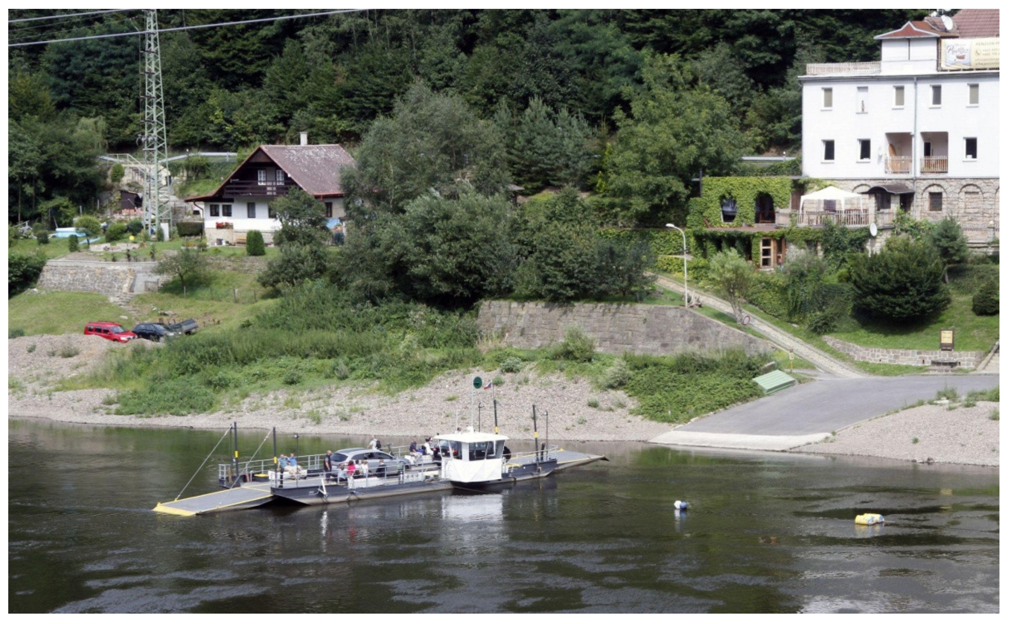
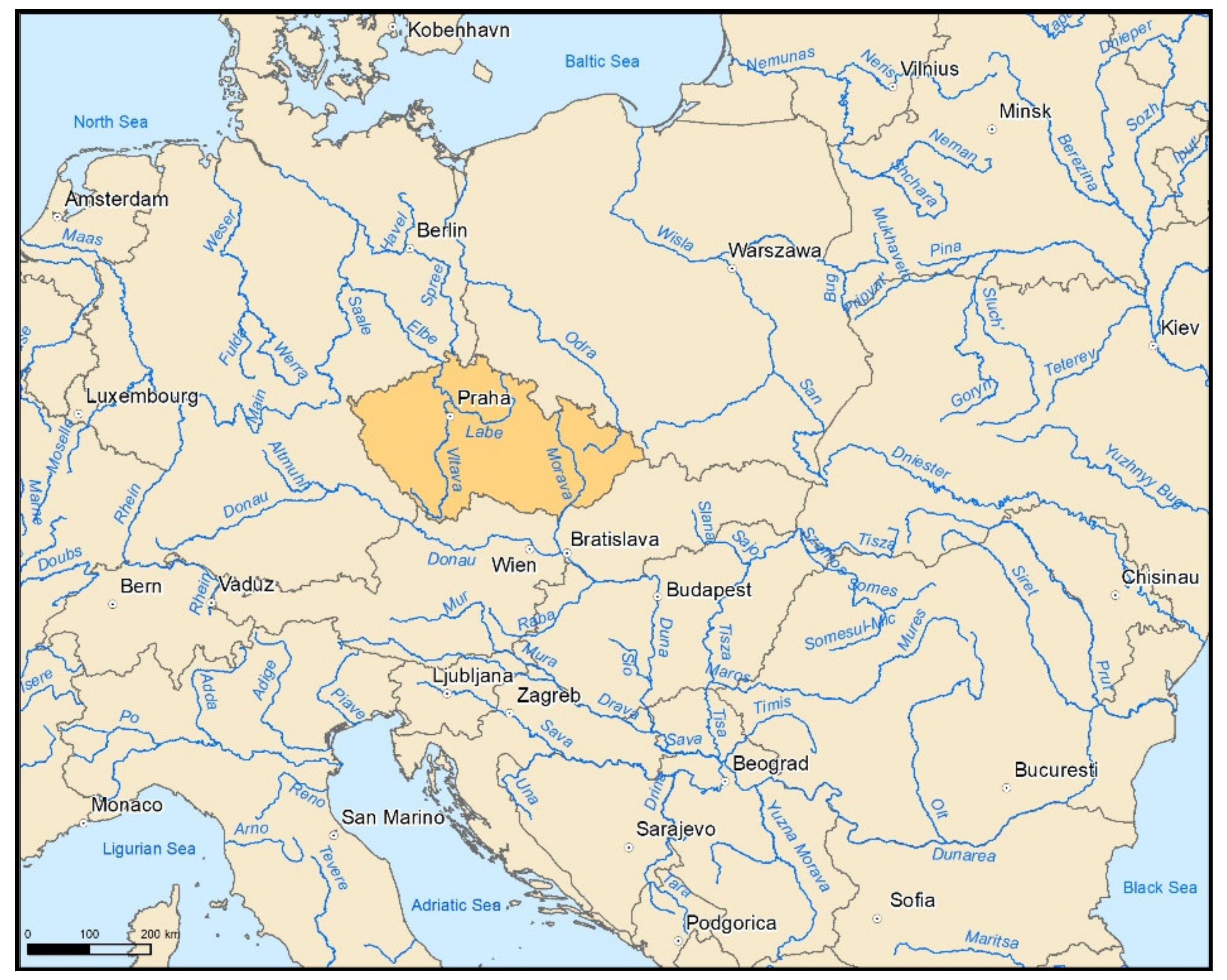
2.1. Study Area
2.2. Historical Mappings within the Czech Republic
2.3. Map Processing
3. Results
3.1. Cartographic Analysis of the Forms of Depicting Ferries in the Individual Surveys
3.2. Spatial Distribution of Historical Ferry Locations
3.3. Verification Using Navigation Charts and Water Books
3.3.1. Navigation Charts for the Labe between Lovosice and Kolín and the Vltava beyond Prague
3.3.2. Water Books for the Region of Central Sázava in the 1950s
4. Discussion
5. Conclusions
- -
- The maps of the 1st Austrian military mapping showed considerable positional inaccuracy, especially in terms of the cartographic representations used and the quality of the map copies, which are approximately 250 years old;
- -
- The thematic content was processed by individual mapmakers, meaning that differences in recorded details may occur across the map sheets;
- -
- Each of the mappings captured the conditions at a specific time, suggesting that, during the long time periods between the mappings, some ferries may have emerged and disappeared without being recorded.
Author Contributions
Funding
Institutional Review Board Statement
Informed Consent Statement
Data Availability Statement
Acknowledgments
Conflicts of Interest
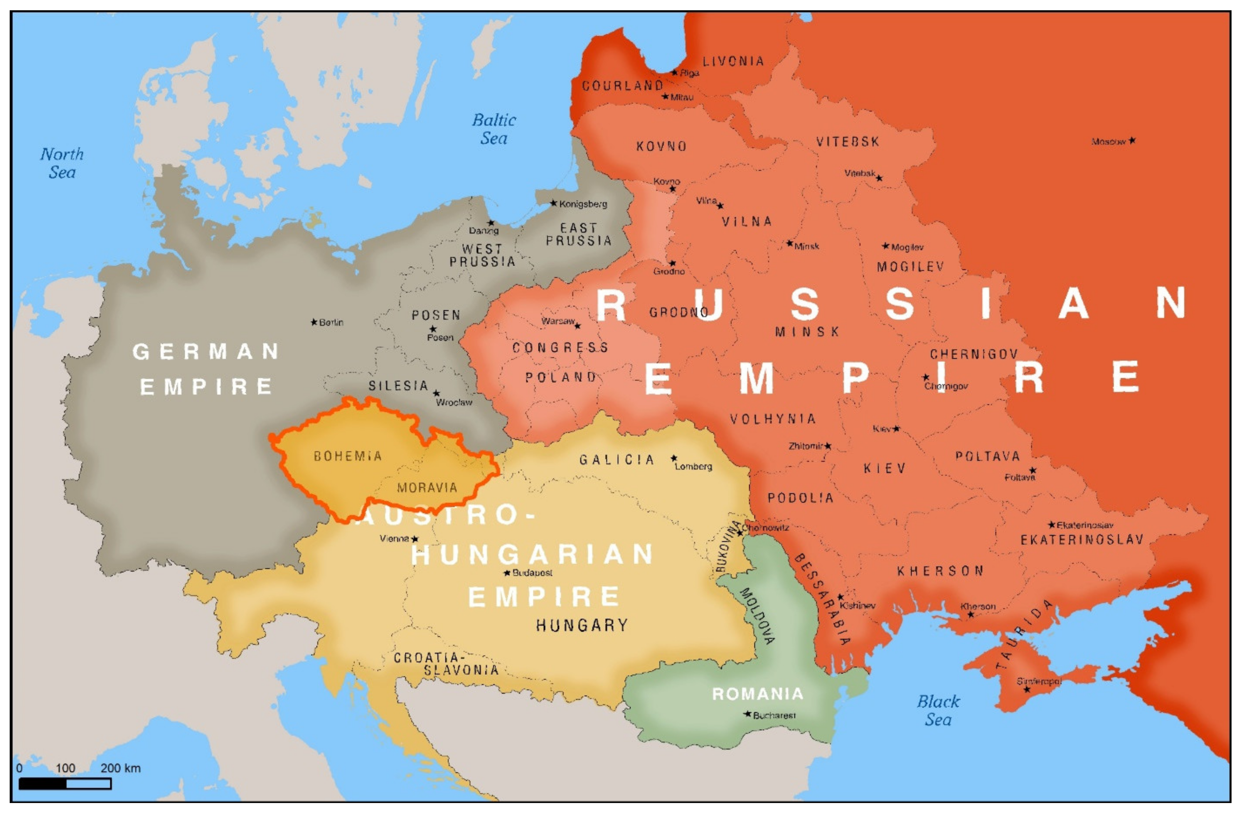
Appendix A. Historical Background

Appendix B


References
- Martínek, J.; Létal, A.; Miřijovský, J.; Šlézar, P.; Vích, D.; Kalábek, M. Poznáváme Historické Cesty. 1. Vyd; Centrum Dopravního Výzkumu: Brno, Czech Republic, 2014; p. 238. [Google Scholar]
- Ivanič, P. Tolls in the Middle Ages in the Hron and Žitava Regions. Hist. Cas. 2020, 67, 541–553. [Google Scholar] [CrossRef]
- Hraše, J.K. Zemské Stezky, Strážnice a Brány v Čechách; J.K. Hraše: Nové Město nad Metují, Czech Republic, 1885; p. 183. [Google Scholar]
- Čížek, K. Právo Vodní Dle Zákona Ze Dne 28. Srpna 1870 Pro Království České.; Tisk a Sklad Jindř. Mercyho: Prague, Czech Republic, 1886; p. 643. [Google Scholar]
- Solomon, B.; Otoo, E.; Boateng, A.; Ato Koomson, D. Inland Waterway Transportation (IWT) in Ghana: A case study of Volta Lake Transport. Int. J. Transp. Sci. Technol. 2021, 10, 20–33. [Google Scholar] [CrossRef]
- Bignon, E.; Pojani, D. River-based public transport: Why won’t Paris jump on board? Case Stud. Transp. Policy 2018, 6, 200–205. [Google Scholar] [CrossRef] [Green Version]
- Deka, D.; Carnegie, J. Predicting transit mode choice of New Jersey workers commuting to New York City from a stated preference survey. J. Transp. Geogr. 2021, 91, 102965. [Google Scholar] [CrossRef]
- Soltani, A.; Tanko, M.; Burke, M.I.; Farid, R. Travel Patterns of Urban Linear Ferry Passengers Analysis of Smart Card Fare Data for Brisbane, Queensland, Australia. Transp. Res. Rec. J. Transp. Res. Board 2015, 2535, 79–87. [Google Scholar] [CrossRef]
- Sipe, N.; Burke, M.I. Can River Ferries Deliver Smart Growth? Transp. Res. Rec. J. Transp. Res. Board 2011, 2217, 79–86. [Google Scholar] [CrossRef]
- Camay, S.; Zielinski, E.; Zaranko, A. New York City’s East River Ferry Expanding Passenger Ferry Service and Stimulating Economic Development in the New York City Region. Transp. Res. Rec. J. Transp. Res. Board 2012, 2274, 192–200. [Google Scholar] [CrossRef]
- Vilain, P.B.; Cox, J.; Mantero, V. Public Policy Objectives and Urban Transit Case of Passenger Ferries in the New York City Region. Transp. Res. Rec. J. Transp. Res. Board 2012, 2274, 184–191. [Google Scholar] [CrossRef]
- Nyunt, K.T.K.; Wongchavalidkul, N. Evaluation of Relationships Between Ridership Demand and Transit-Oriented Development (TOD) Indicators Focused on Land Use Density, Diversity, and Accessibility: A Case Study of Existing Metro Stations in Bangkok. Urban Rail Transit 2020, 6, 56–70. [Google Scholar] [CrossRef] [Green Version]
- Tarkowski, M.; Połom, M.; Puzdrakiewicz, K. Bridging tourist attractions. The role of waterbuses in urban tourism development: The case of the coastal city of Gdańsk (Poland). Geoj. Tour. Geosites 2021, 34, 126–131. [Google Scholar] [CrossRef]
- McGrath, E.; Harmer, N.; Yarwood, R. Ferries as travelling landscapes: Tourism and watery mobilities. Int. J. Cult. Tour. Hosp. Res. 2020, 14, 321–334. [Google Scholar] [CrossRef]
- Timár, G.; Molnár, G.; Székely, B.; Biszak, S.; Varga, J.; Jankó, A. Digitized Maps of the Habsburg Empire—The Map Sheets of the Second Military Survey and their Georeferenced Version. Acta Geod. Geophys. Hung. 2009, 44, 115–120. [Google Scholar]
- Prokop, P. The first medium-scale topographic map of Galicia (1779–1783)—Survey, availability and importance. Geogr. Pol. 2017, 90, 97–104. [Google Scholar] [CrossRef] [Green Version]
- Janata, T.; Cajthaml, J. Georeferencing of Multi-Sheet Maps Based on Least Squares with Constraints—First Military Mapping Survey Maps in the Area of Czechia. Appl. Sci. 2020, 11, 299. [Google Scholar] [CrossRef]
- Loran, C.; Haegi, S.; Ginzler, C. Comparing historical and contemporary maps—A methodological framework for a cartographic map comparison applied to Swiss maps. Int. J. Geogr. Inf. Sci. 2018, 32, 2123–2139. [Google Scholar] [CrossRef]
- Skokanova, H.; Falťan, V.; Havlíček, M. Driving forces of main landscape change processes from the past 200 years in Central Europe—Differences between old democratic and post-socialist countries. Ekológia Bratisl. 2016, 35, 50–65. [Google Scholar] [CrossRef] [Green Version]
- Amici, V.; Maccherini, S.; Santi, E.; Torri, D.; Vergari, F.; Del Monte, M. Long-term patterns of change in a vanishing cultural landscape: A GIS-based assessment. Ecol. Inform. 2017, 37, 38–51. [Google Scholar] [CrossRef]
- Bürgi, M.; Salzmann, D.; Gimmi, U. 264 years of change and persistence in an agrarian landscape: A case study from the Swiss lowlands. Landsc. Ecol. 2015, 30, 1321–1333. [Google Scholar] [CrossRef]
- Nicu, I.C.; Stoleriu, C.C. Land use changes and dynamics over the last century around churches of Moldavia, Bukovina, Northern Romania—Challenges and future perspectives. Habitat Int. 2019, 88, 101979. [Google Scholar] [CrossRef]
- Schaffer, G.; Levin, N. Reconstructing nineteenth century landscapes from historical maps—The Survey of Western Palestine as a case study. Landsc. Res. 2015, 41, 360–379. [Google Scholar] [CrossRef]
- Incze, J.; Novák, T.J. Identification of extent, topographic characteristics and land abandonment process of vineyard terraces in the Tokaj-Hegyalja wine region between 1784 and 2010. J. Maps 2016, 12, 507–513. [Google Scholar] [CrossRef]
- Karlík, L.; Gábor, M.; Falťan, V.; Lauko, V. Monitoring of vineyards utilization: Case study Modra (Slovakia). Geogr. Cassoviensis 2017, 11, 22–32. [Google Scholar]
- Jaworek-Jakubska, J.; Filipiak, M.; Napierała-Filipiak, A. Understanding of Forest Cover Dynamics in Traditional Landscapes: Mapping Trajectories of Changes in Mountain Territories (1824–2016), on the Example of Jeleniogórska Basin, Poland. Forests 2020, 11, 867. [Google Scholar] [CrossRef]
- De Keersmaeker, L.; Onkelinx, T.; De Vos, B.; Rogiers, N.; Vandekerkhove, K.; Thomaes, A.; De Schrijver, A.; Hermy, M.; Verheyen, K. The analysis of spatio-temporal forest changes (1775–2000) in Flanders (northern Belgium) indicates habitat-specific levels of fragmentation and area loss. Landsc. Ecol. 2014, 30, 247–259. [Google Scholar] [CrossRef]
- Pavelková, R.; Frajer, J.; Havlíček, M.; Netopil, P.; Rozkošný, M.; David, V.; Dzuráková, M.; Šarapatka, B. Historical ponds of the Czech Republic: An example of the interpretation of historic maps. J. Maps 2016, 12, 551–559. [Google Scholar] [CrossRef] [Green Version]
- Frajer, J.; Pavelková, R.; Létal, A.; Kopp, J. Relics and transformation of former ponds in the urban environment of the historical region of Bohemia (Czech Republic). J. Maps 2020, 1–11. [Google Scholar] [CrossRef]
- Mărgărint, M.C.; Niculiţă, M.; Németh, A.; Cristea, A.I.; Doru, S.C. The reconstruction of an abandoned historical reservoir network in a continental temperate climate region using a multi-method approach. Appl. Geogr. 2021, 130, 102447. [Google Scholar] [CrossRef]
- Kolejka, J.; Krejčí, T.; Nováková, E. The Pre-industrial landscape in Moravia. The case study of inventory and analysis of the ancient land use structures in the Czech Republic. Land Use Policy 2020, 97, 104712. [Google Scholar] [CrossRef]
- Petrovič, F.; Petrikovičová, L. Landscape Tranformation of Small Rural Settlements with Dispersed Type of Settlement in Slovakia. Eur. Countrys. 2021, 13, 455–478. [Google Scholar] [CrossRef]
- Svenningsen, S. Mapping the Nation for War: Landscape in Danish Military Cartography 1800–2000. Imago Mundi 2016, 68, 196–211. [Google Scholar] [CrossRef]
- Rastner, P.; Joerg, P.; Huss, M.; Zemp, M. Historical analysis and visualization of the retreat of Findelengletscher, Switzerland, 1859–2010. Glob. Planet. Chang. 2016, 145, 67–77. [Google Scholar] [CrossRef]
- Jedlička, J.; Havlíček, M.; Dostál, I.; Huzlík, J.; Skokanova, H. Assessing Relationships between Land Use Changes and the Development of a Road Network in the Hodonín Region (Czech Republic). Quaest. Geogr. 2019, 38, 145–159. [Google Scholar] [CrossRef] [Green Version]
- Skládaná, P.; Havlíček, M.; Dostál, I.; Skládaný, P.; Tučka, P.; Perůtka, J. Land Use as a Motivation for Railway Trespassing: Experience from the Czech Republic. Land 2018, 7, 1. [Google Scholar] [CrossRef] [Green Version]
- Dunesme, S.; Piégay, H.; Mustière, S. Assessing Historical Maps for Characterizing Fluvial Corridor Changes at a Regional Network Scale. Cartogr. Int. J. Geogr. Inf. Geovisualization 2020, 55, 251–265. [Google Scholar] [CrossRef]
- Šantrůčková, M.; Demková, K.; Weber, M.; Lipský, Z.; Dostálek, J. Long term changes in water areas and wetlands in an intensively farmed landscape: A case study from the Czech Republic. Eur. Countrys. 2017, 9, 132–144. [Google Scholar] [CrossRef] [Green Version]
- García, J.H.; Dunesme, S.; Piégay, H. Can we characterize river corridor evolution at a continental scale from historical topographic maps? A first assessment from the comparison of four countries. River Res. Appl. 2019, 36, 934–946. [Google Scholar] [CrossRef]
- Blanco, A.; de Bustamante, I.; Aguilar, J.A.P. Using old cartography for the inventory of a forgotten heritage: The hydraulic heritage of the Community of Madrid. Sci. Total Environ. 2019, 665, 314–328. [Google Scholar] [CrossRef] [PubMed]
- Skokanová, H.; Pavelková, R.; Havlíček, M.; Létal, A. Identification of Potential Localities for Restoring Former Historical Ponds: Case Studies from the Czech Republic. Geogr. Inf. 2020, 24, 315–328. [Google Scholar] [CrossRef]
- Suziedelyte-Visockiene, J.; Stanionis, A.; Tumeliene, E.; Puziene, R. Analyses of Archival Cartographic Materials for Geomorphological Changes of River Channel. Adv. Civ. Eng. 2018, 2018, 8502780. [Google Scholar] [CrossRef]
- Horáčková, Š.; Pišút, P.; Falťan, V.; Chovanec, P.; Petrovič, F. Historical Changes and Vegetation Development after Intensive Peat Extraction in the Lowland Mires of Slovakia. Appl. Ecol. Environ. Res. 2018, 16, 5025–5045. [Google Scholar] [CrossRef]
- Sosnowska, A. Dynamics of mid-channel bars in the Middle Vistula River in response to ferry crossing abutment construction. Open Geosci. 2020, 12, 290–298. [Google Scholar] [CrossRef]
- Fröhlich, J. Stará Otava Mezi Pískem a Zvíkovem; Prácheňské Nakladatelství: Písek, Czech Republic, 2012; p. 113. ISBN 978-80-86566-53-5. [Google Scholar]
- Tihelka, E. Zaniklé sázavské přívozy na Kutnohorsku. Kutnohorsko 2017, 19, 29–35. [Google Scholar]
- Wang, J. Ferry Distribution at the Lower Reaches of the Yellow River on the Former Japanese Military Maps. Jpn. J. Hum. Geogr. 2020, 72, 21–38. [Google Scholar] [CrossRef]
- Havlíček, M.; Dostál, I. Ferry Boats in Moravia and Silesia in Historical Context. Geogr. Inf. 2020, 24, 55–69. [Google Scholar] [CrossRef]
- MKOL. Labe a Jeho Povodí—Geografický, Hydrologický A Vodohospodářský Přehled.; Mezinárodní Komise Pro Ochranu Labe: Magdeburg, Germany, 2005; p. 258. [Google Scholar]
- Mackovčin, P. Land use categorization based on topographic maps. Acta Pruhoniciana 2009, 91, 5–13. [Google Scholar]
- Skokanová, H.; Havlíček, M.; Borovec, R.; Demek, J.; Eremiášová, R.; Chrudina, Z.; Mackovčin, P.; Rysková, R.; Slavík, P.; Stránská, T.; et al. Development of land use and main land use change processes in the period 1836–2006: Case study in the Czech Republic. J. Maps 2012, 8, 88–96. [Google Scholar] [CrossRef] [Green Version]
- Affek, A. Georeferencing of historical maps using GIS, as exemplified by the Austrian Military Surveys of Galicia. Geogr. Pol. 2013, 86, 375–390. [Google Scholar] [CrossRef]
- National Archives of the Czech Republic. Collection Ministry of Transportation 1953–1960, Supplements; Confidential, Box 33, Document 01895/1959; National Archives of the Czech Republic: Prague, Czech Republic, 0189; Volume 33. [Google Scholar]
- Komárková, M. Padesát let vodního díla Slapy. Vodn. Hospodářství 2005, 55, 160–161. [Google Scholar]
- Silniční a dálniční síť ČR. Available online: https://geoportal.rsd.cz/apps/silnicni_a_dalnicni_sit_cr_verejna (accessed on 4 July 2021).
- LeCaine Agnew, H. The Czechs and the Lands of the Bohemian Crown; Hoover Institution Press: Stanford, CA, USA, 2004; p. 441. ISBN 0-8179-4492-3. [Google Scholar]
- Pánek, J. A history of Czech Lands; Karolinum: Prague, Czech Republic, 2009; p. 639. ISBN 978-80-246-1645-2. [Google Scholar]
- Dejmek, J. Versailles, St-Germain, Trianon a Dotváření Poválečného Mírového Systému; Práce Historického Ústavu AV ČR 37 (Opera Instituti Historici Pragae 37); Řada A. Historický Ústav: Prague, Czech Republic, 2011; p. 518. ISBN 978-80-7286-188-0. [Google Scholar]
- Brisku, A. Renegotiating the empire, forging the nation (-state): The Bohemian/Czechoslovakian case through the political–economic thought of Thomas G. Masaryk and Karel Kramář, c. 1890–1920s. Natl. Pap. 2017, 45, 632–650. [Google Scholar] [CrossRef]
- Niemiec, D.; Vahalíková, V.; Duraj, M.; Barcuchová, K.; Marschalko, M. Geotourism purposes—Historical changes in Europe and their impact on the Hlucin region using historical maps. In Proceedings of the International Multidisciplinary Scientific GeoConference Surveying Geology and Mining Ecology Management, SGEM, Albena, Bulgaria, 30 June–6 July 2016; Volume 3, pp. 843–850. [Google Scholar] [CrossRef]
- Topographic Maps of Eastern Europe. Available online: http://easteurotopo.org (accessed on 3 September 2021).


| Mapping | Period | Scale | Approximate Accuracy [m] |
|---|---|---|---|
| 1st Austrian military survey | 1763–1768 | 1:28,800 | 300 |
| 2nd Austrian military survey | 1836–1852 | 1:28,800 | 30 |
| 3rd Austrian military survey | 1876–1880 | 1:25,000 | 25 |
| Prussian survey | 1825; 1877 | 1:25,000 | 25 |
| Czechoslovakian military mapping | 1952–1956 | 1:25,000 | 15 |
| Period | |||||
|---|---|---|---|---|---|
| Type of Ferry | 1763–1768 | 1836–1852 | 1876–1880 | Prussia 1877 | 1953–1955 |
| Pedestrian ferry |   |  |  |  |  |
| Ferry for horses |  |  |  |  | |
| Ferry for carriages |  |  |  |  | |
| Reaction ferry | n/a |  |  |  | |
| Steam-powered ferry | n/a | n/a |  |  | n/a |
| Period | ||||||
|---|---|---|---|---|---|---|
| River | 1763–1768 | 1836–1852 | 1876–1880 | 1953–1955 | 2020 | Over Time |
| Bečva | 1 | 5 | 5 | |||
| Berounka | 7 | 55 | 38 | 15 | 3 | 66 |
| Dyje | 1 | 1 | 1 | 2 | ||
| Jizera | 1 | 3 | 6 | 3 | 1 | 9 |
| Labe | 30 | 63 | 74 | 43 | 10 | 129 |
| Lužnice | 10 | 8 | 4 | 5 | 15 | |
| Morava | 6 | 6 | 8 | 4 | 15 | |
| Moravice | 1 | 1 | ||||
| Odra | 1 | 7 | 2 | 7 | ||
| Ohře | 12 | 28 | 26 | 5 | 1 | 51 |
| Olše | 2 | 1 | 2 | |||
| Opava | 2 | 1 | 2 | |||
| Orlice | 3 | 1 | 3 | |||
| Otava | 5 | 11 | 7 | 4 | 15 | |
| Sázava | 4 | 10 | 23 | 12 | 1 | 34 |
| Střela | 1 | 1 | ||||
| Svratka | 1 | 1 | 1 | |||
| Vltava | 49 | 60 | 96 | 31 | 16 | 156 |
| Total | 126 | 260 | 290 | 128 | 33 | 514 |
| Numbers of Time Periods | ||||||
|---|---|---|---|---|---|---|
| River | 1 | 2 | 3 | 4 | 0 * | Over Time |
| Bečva | 4 | 1 | 5 | |||
| Berounka | 30 | 22 | 12 | 2 | 4 | 70 |
| Dyje | 1 | 1 | 2 | |||
| Jizera | 6 | 2 | 1 | 9 | ||
| Labe | 72 | 32 | 16 | 9 | 6 | 135 |
| Lužnice | 8 | 3 | 3 | 1 | 2 | 17 |
| Morava | 9 | 3 | 3 | 15 | ||
| Moravice | 1 | 1 | ||||
| Odra | 5 | 1 | 1 | 7 | ||
| Ohře | 36 | 10 | 4 | 1 | 1 | 52 |
| Olše | 1 | 1 | 2 | |||
| Opava | 1 | 1 | 2 | |||
| Orlice | 2 | 1 | 3 | |||
| Otava | 8 | 4 | 1 | 2 | 15 | |
| Sázava | 24 | 4 | 6 | 3 | 37 | |
| Střela | 1 | 1 | ||||
| Svratka | 1 | 1 | ||||
| Vltava | 93 | 39 | 15 | 9 | 12 | 168 |
| Total | 302 | 126 | 61 | 25 | 28 | 542 |
| Period | ||||||
|---|---|---|---|---|---|---|
| Elevation [m] | 1763–1768 | 1836–1852 | 1876–1880 | 1953–1955 | 2020 | Over Time * |
| up to 150 | 13 | 20 | 26 | 13 | 6 | 46 |
| 10.3% | 7.7% | 9.0% | 10.2% | 18.2% | 8.5% | |
| 151–200 | 29 | 72 | 95 | 53 | 15 | 184 |
| 23.0% | 27.7% | 32.8% | 41.4% | 45.5% | 33.9% | |
| 201–250 | 9 | 57 | 47 | 19 | 2 | 79 |
| 7.1% | 21.9% | 16.2% | 14.8% | 6.1% | 14.6% | |
| 251–300 | 30 | 57 | 58 | 22 | 6 | 111 |
| 23.8% | 21.9% | 20.0% | 17.2% | 18.2% | 20.5% | |
| 301–400 | 43 | 47 | 57 | 21 | - | 103 |
| 34.1% | 18.1% | 19.7% | 16.4% | 0.0% | 19.0% | |
| 401–500 | 2 | 6 | 7 | - | 1 | 15 |
| 1.6% | 2.3% | 2.4% | 0.0% | 3.0% | 2.8% | |
| 501 and above | - | 1 | - | - | 3 | 4 |
| 0.0% | 0.4% | 0.0% | 0.0% | 9.1% | 0.7% | |
| Total | 126 | 260 | 290 | 128 | 33 | 542 |
| 100.0% | 100.0% | 100.0% | 100.0% | 100.0% | 100.0% | |
| River Section | A | B | C | D | E |
|---|---|---|---|---|---|
| Labe (Mělník–Kolín) | 18 | 15 | 3 | 0 | 0 |
| Labe (Mělník–Lovosice) | 13 | 6 | 7 | 0 | 0 |
| Vltava (Praha–Troja–Mělník) | 15 | 11 | 3 | 1 | 1 |
| Total | 46 | 32 | 13 | 1 | 1 |
| 100.0% | 69.6% | 28.3% | 2.2% | - |
Publisher’s Note: MDPI stays neutral with regard to jurisdictional claims in published maps and institutional affiliations. |
© 2021 by the authors. Licensee MDPI, Basel, Switzerland. This article is an open access article distributed under the terms and conditions of the Creative Commons Attribution (CC BY) license (https://creativecommons.org/licenses/by/4.0/).
Share and Cite
Dostál, I.; Havlíček, M.; Svoboda, J. There Used to Be a River Ferry: Identifying and Analyzing Localities by Means of Old Topographic Maps. Water 2021, 13, 2689. https://doi.org/10.3390/w13192689
Dostál I, Havlíček M, Svoboda J. There Used to Be a River Ferry: Identifying and Analyzing Localities by Means of Old Topographic Maps. Water. 2021; 13(19):2689. https://doi.org/10.3390/w13192689
Chicago/Turabian StyleDostál, Ivo, Marek Havlíček, and Josef Svoboda. 2021. "There Used to Be a River Ferry: Identifying and Analyzing Localities by Means of Old Topographic Maps" Water 13, no. 19: 2689. https://doi.org/10.3390/w13192689
APA StyleDostál, I., Havlíček, M., & Svoboda, J. (2021). There Used to Be a River Ferry: Identifying and Analyzing Localities by Means of Old Topographic Maps. Water, 13(19), 2689. https://doi.org/10.3390/w13192689