1. Introduction
Climate change is related to the change in the long-term mean of precipitation and temperature values. However, urge to understand the change in the extreme events, because these climate phenomena produce uncountable damages to the human life and extensive impacts on the ecosystems [
1]. Various studies have shown that the occurrence of some extreme events (e.g., extreme precipitation events and heat waves) have had a human contribution [
2,
3,
4,
5]. According to [
4], the moderate precipitation events have increased by 18% due to the Earth’s temperature rise since the pre-industrial era. In this sense, climate models predict a continuous increase of temperature, which is related to an increase in extreme precipitation events during the 21st and in some regions an intensification of the water cycle [
5,
6,
7,
8,
9].
Generally, studies that work with climatic extremes use daily or sub-daily precipitation and temperature data, either from gauge stations, Reanalysis data, or climate models simulations [
5,
10,
11]. However, sometimes the analysis of ground-based precipitation data suggests a reduction in extreme precipitation events in regions where temperatures are increasing [
12]. These results generate uncertainty about the future trend of extreme precipitation events because, in general, a worsening of extreme events is expected with a positive change of mean temperatures [
13].
Most of the studies that analyse climate change scenarios are focused on annual averages. However, the inclusion of daily data, although more difficult to process, provide insights related to the extreme precipitation events, which are responsible for a large part of the environmental and social damage attributed to the climate [
14,
15]. Despite their importance, these observations are less frequent and, thus, more difficult to acquire. In this sense, data-scarce regions, such as Colombia, lack of dense networks of meteorological stations, which hinders the spatio-temporal characterisation of precipitation [
16]. However, several precipitation products (
P products) provide estimates related to the spatio-temporal distribution of precipitation, which enables the analysis of precipitation extremes over data-scarce regions [
17,
18,
19,
20,
21,
22,
23].
The El Niño—Southern Oscillation (ENSO) has a strong influence on the global climate system [
24,
25] as it is one of the main drivers of the inter-annual variability of precipitation extremes in different regions of the planet (i.e., droughts spells and heavy rain events). Therefore, understanding the influence that the ENSO has on the extreme precipitation events is pivotal to assess their economic impacts and the risks associated with them to strive towards the implementation of adaptation measures [
26,
27]. These measures are of utmost importance for Colombia since the country is frequently affected by extreme ENSO events, which differ depending on the ENSO phase (i.e., El Niño/La Niña). For example, in La Niña event of 2010–2011, heavy precipitation, floods, and landslides affected four million people in Colombia and caused a financial loss of about US
$8 billion [
28]. On the other hand, severe reductions in precipitation and river flows have been widely recorded during El Niño years in Colombia [
28,
29,
30,
31], which have led to energy cutoffs due to the great magnitude of the droughts that frequently impact the country’s economy [
32,
33,
34].
The majority of studies that focus on extreme events select only one event per year, following the classic hydrology’s definition of return period [
15]. This approach assumes that the extracted annual values are considered a set of
independent and
identically distributed random variables (
i.i.d.); therefore, a probability distribution could be used to fit the data. However, sometimes the water processes are affected by inter-annual variability (i.e., periods greater than one year), causing that the annual values can not be considered a set of
i.i.d. random variables. In this sense, the extreme events may belong to different populations. In our study, we used the ENSO phases distinguish between those populations of extreme events. The ENSO has two extreme phases with a quasi-period occurrence from 3 to 7 years: (i) El Niño (the warm phase) and (ii) La Niña (the cold phase), in addition to the average conditions (normal years) [
24].
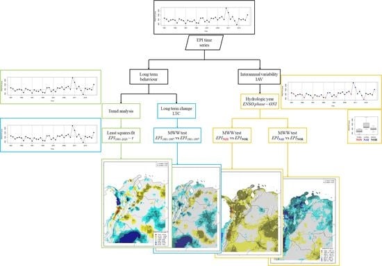
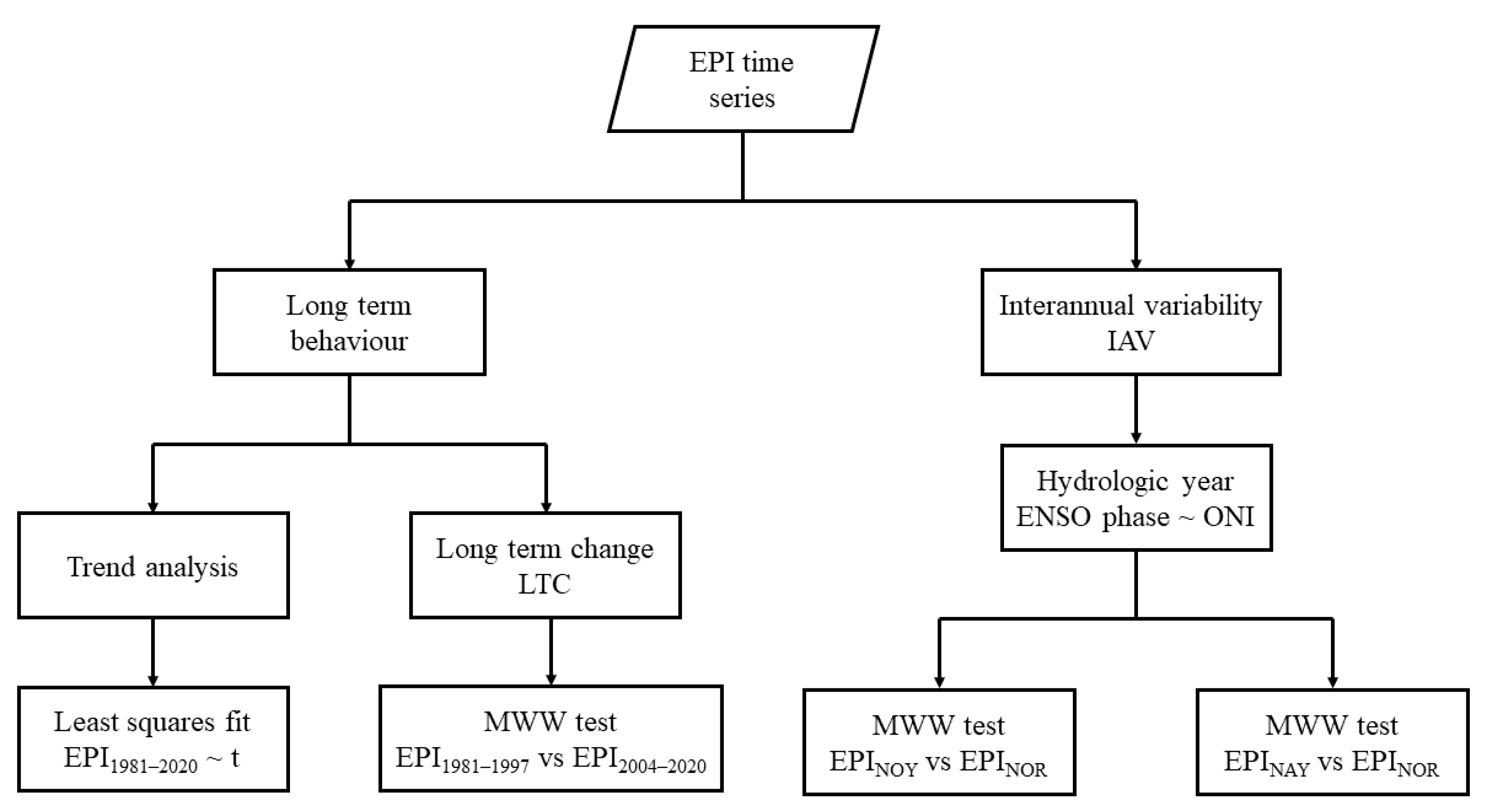
This manuscript wants to answer the question: ¿Is the EPIs long-term change more critical than the EPIs anomalies driven by the ENSO phenomenon? Then, the main objective of the present work is to analyze diverse Extreme Precipitation Indices (EPI) over Colombia from two viewpoints: (i) the long-term change of the EPIs and (ii) the inter-annual variability of the EPIs considering the ENSO phases. However, the Colombian territory is large and diverse, and then another scientific question arises: ¿is the EPIs behavior the same for all the study region? The spatial analysis locates those areas where the long-term changes (or the inter-annual anomalies) are the most important, and link this behavior with their specific climate characteristics.
2. Study Area
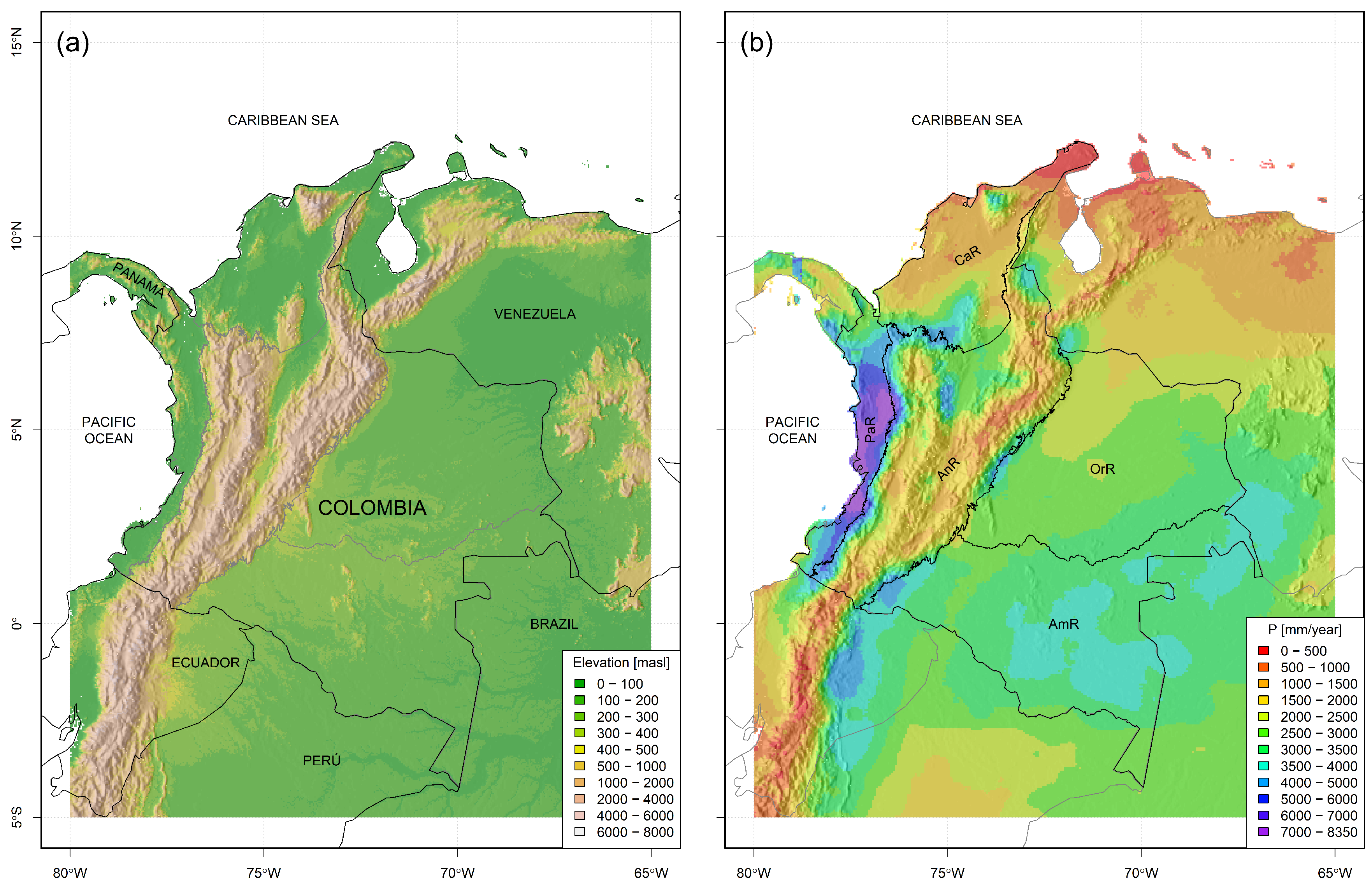
Colombia is a Latin-American country located in the northwest region of South America. It has access to both the Pacific and Atlantic Ocean (through the Caribbean Sea). It is bounded to the east with Venezuela, to the south with Brazil, Peru, and Ecuador, and the northwest with Panama (
Figure 1a).
Colombia’s climate is fueled by moisture inputs from both oceans and the Amazon rainforest to the southeast. Nevertheless, its spatial distribution of precipitation is strongly driven by the Andean Mountain Chain, which crosses the territory in the Southwest-Northeast direction (
Figure 1a,b) [
35]. In this way, the continental territory of Colombia can be divided into five natural regions ([
36,
37]), which share some climatic features: (i) the Caribbean region (CaR), which is the driest and northernmost region of Colombia; (ii) the Pacific region (PaR), which is a super-humid narrow area close to the Pacific coast in the west; (iii) the Andean region (AnR), which is the central mountainous area that the Andes Mountain Chain crosses; (iv) the Orinoco region (OrR), which is the eastern plain dry savanna of Orinoco River Basin; and (v) the Amazon region (AmR), which covers the humid river basin of the Amazonas River.
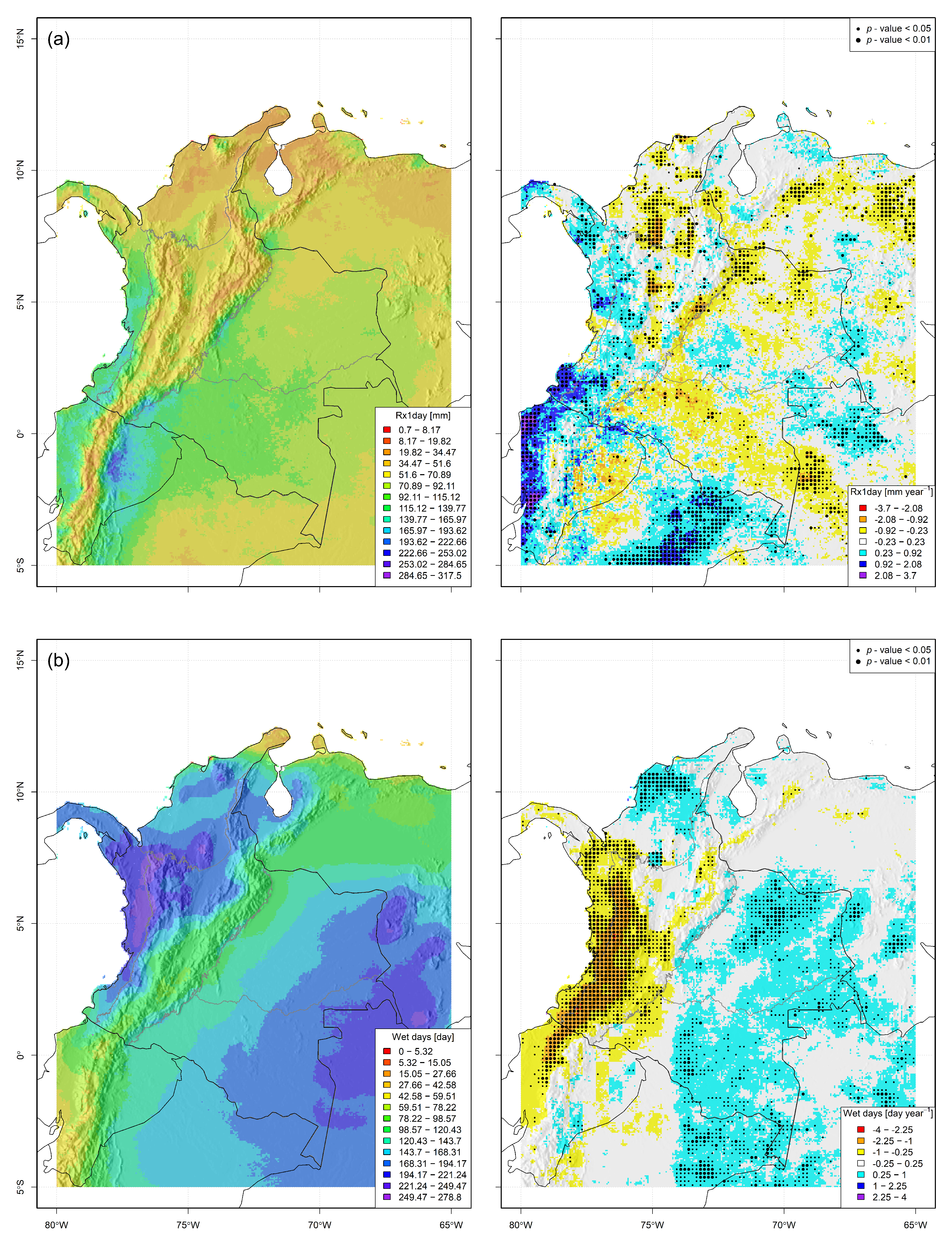
The maps of mean seasonal precipitation of the study area (
Figure 2) reveal particular behaviours: the AnR has two precipitation peaks (MAM and SON), which coincide with the Intertropical Convergence Zone (ITCZ) passage over the mountain chains; the OrR and the AmR have their precipitation peak on JJA; the CaR has the peak during SON, while the PaR has high precipitation values in all seasons. All regions have the lowest precipitation values on DJF. The previous distinction of the annual precipitation cycle between natural regions is fundamental because that condition influences all EPI computation, especially for those EPI related to both dry and wet spells.
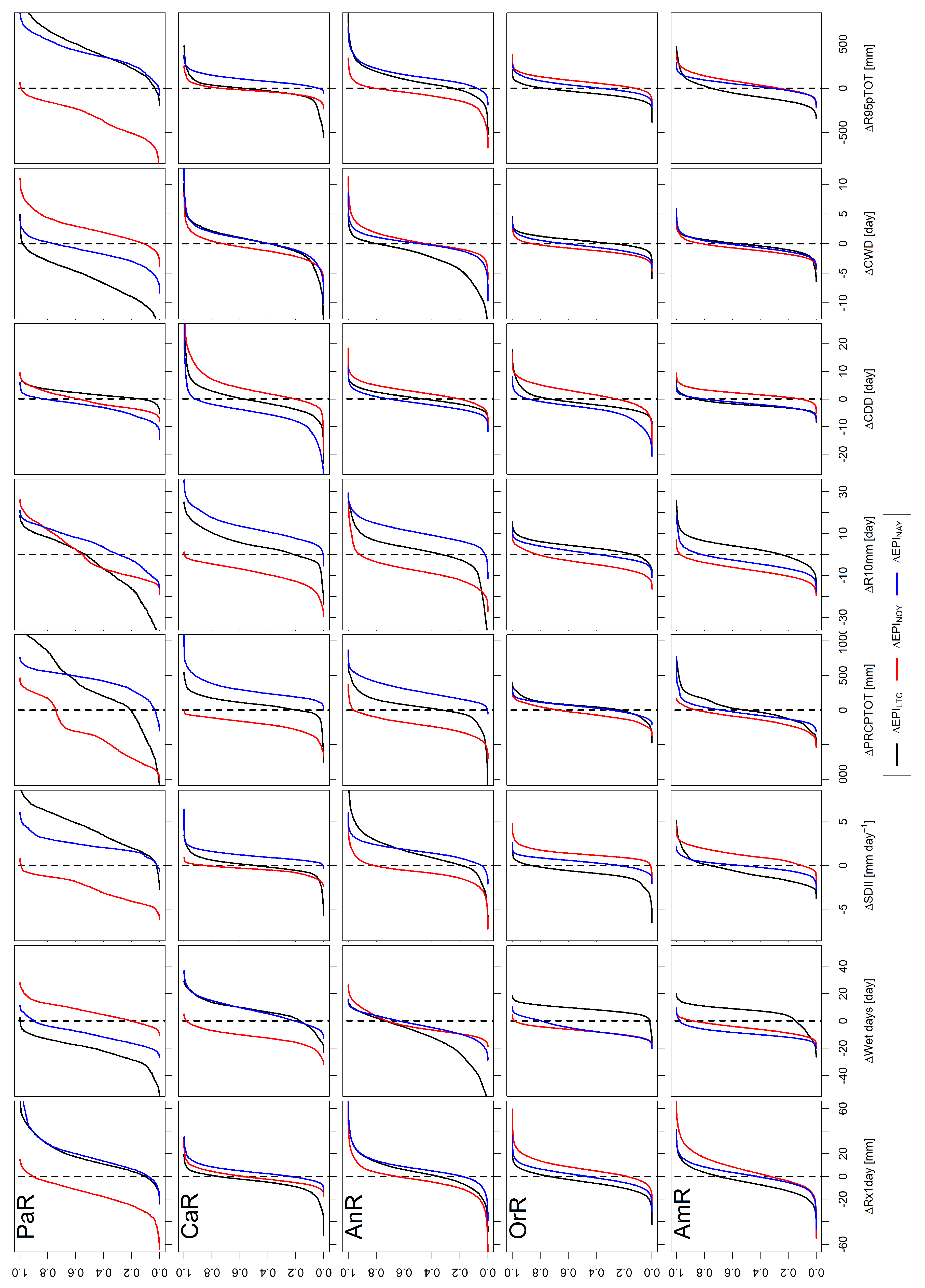
6. Discussion
The territory of Colombia has a different response to extreme precipitation events. The EPIs’ answer depends on whether the change computation is assessed in the long-term fashion, or if it is assessed through anomalies driven by the ENSO phenomenon. Furthermore, EPIs’ response during El Niño years is different from that observed during La Niña years. The
Figure 14 facilitates the comparison between the long-term changes, and the inter-annual anomalies, computed for each EPI. The figure shows the distribution of the values calculated for
,
, and
, but restricted for each region.
In general, all Colombian regions show long-term changes of extreme precipitation indices to a greater or lesser extent. Still, not all of them are affected by the ENSO phenomenon. The most affected regions by ENSO are:
the Pacific narrow lowlands at the west (PaR),
the Andean mountainous region at the center (AnR), and
the Caribbean sea northern plains (CaR).
However, it was observed that the eastern plains of Colombia (i.e., Orinoquia plus Amazonian region, OrR + AmR) have been less affected by ENSO than the rest of the country. This observation agrees with Mesa et al. (2021; [
60]), who said that ENSO affects western Colombia, while eastern regions have a precipitation behavior that is more influenced by the dynamics of the Atlantic Ocean and the Amazon Basin. The work of Salas et al. (2020; [
37]) points out in the same direction; they report that during NAY, eastern Colombia (OrR + AmR) presents drier conditions, while conditions are more humid during NOY, which is an opposite behavior regarding the rest of Colombia. (AnR + CaR + PaR, western Colombia). According to [
37], the synchronization of rain anomalies with the ENSO is exhibited for western Colombia, while that synchronization is not so clear for the eastern plains.
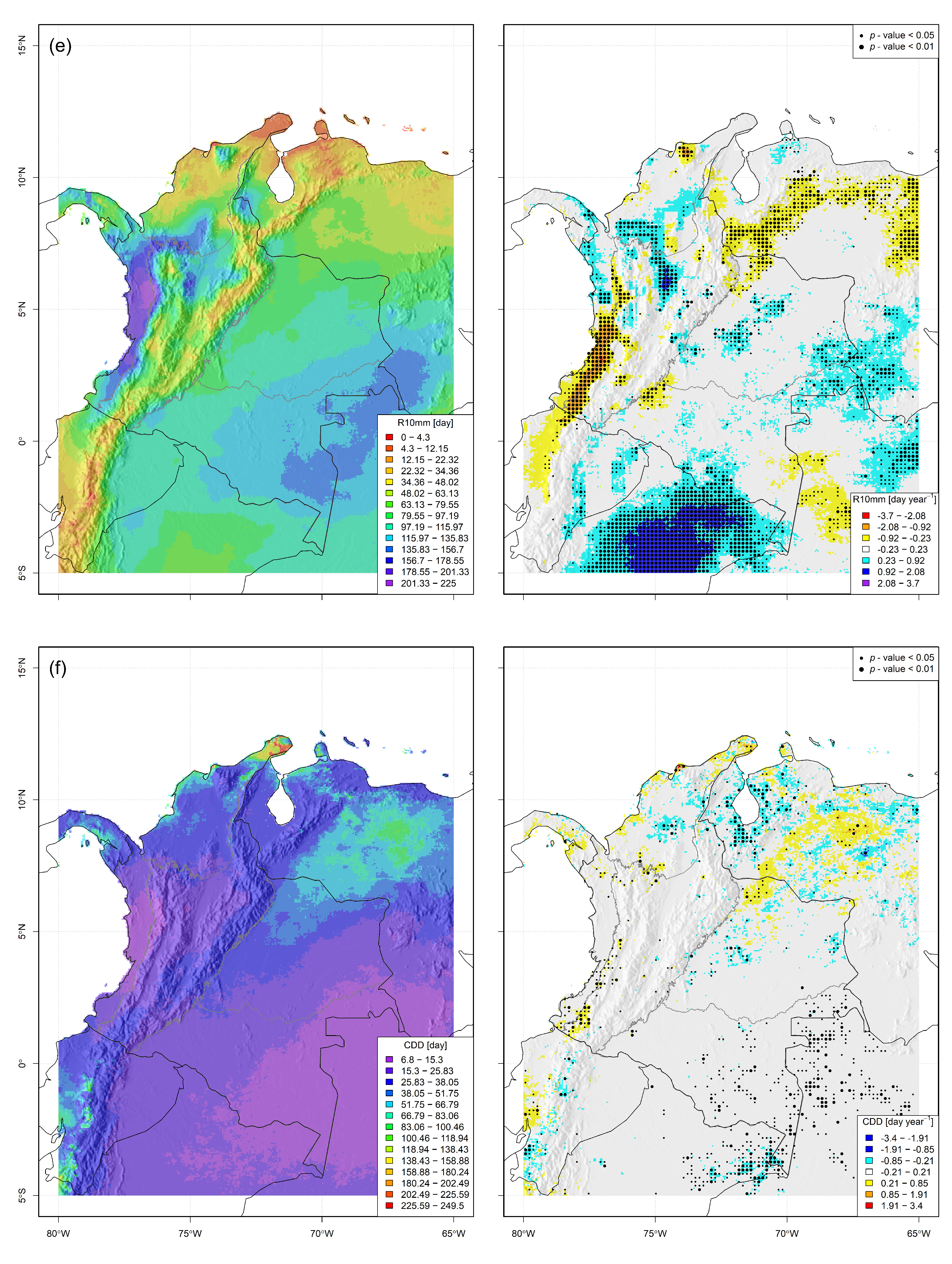
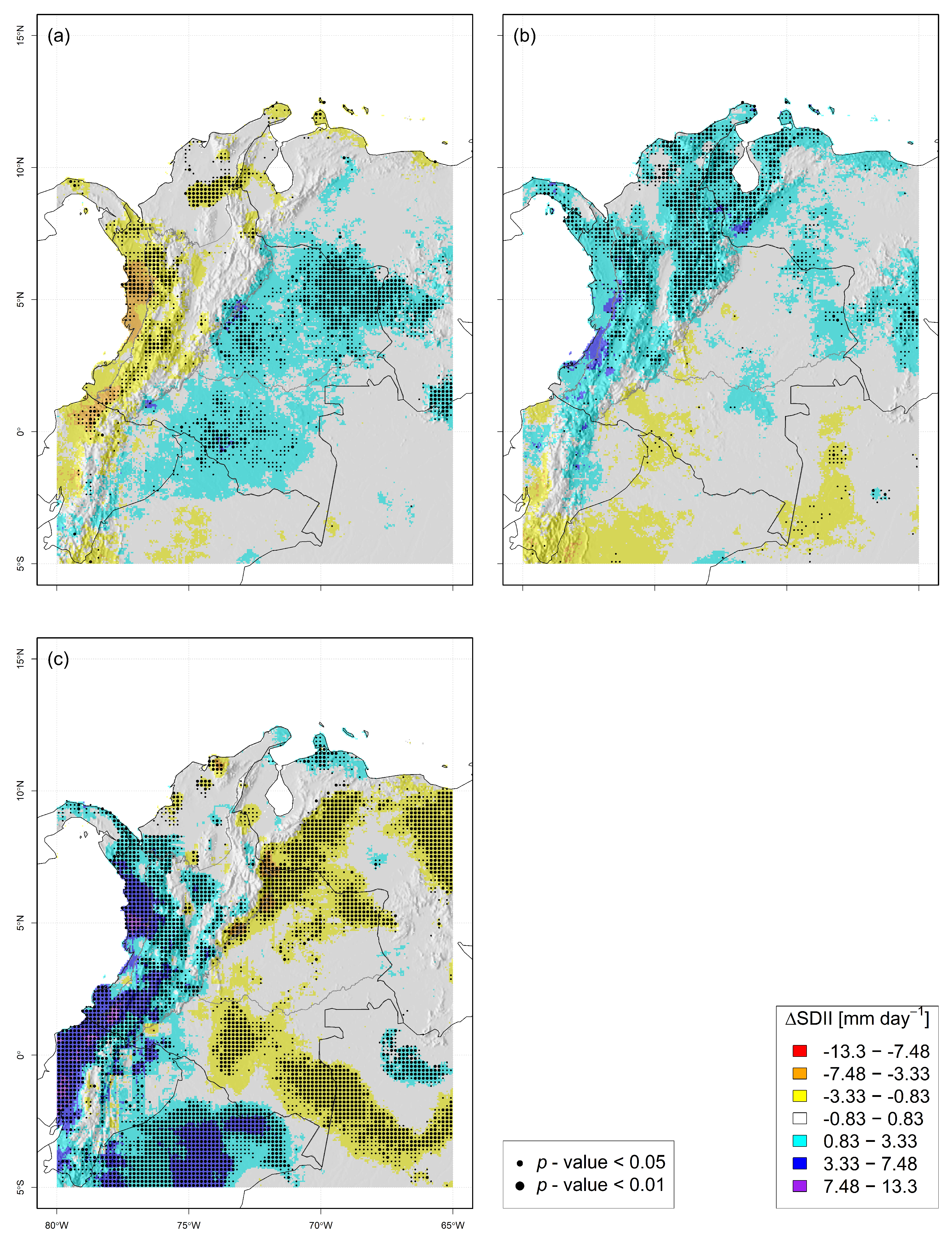
6.1. The Pacific Region—PaR
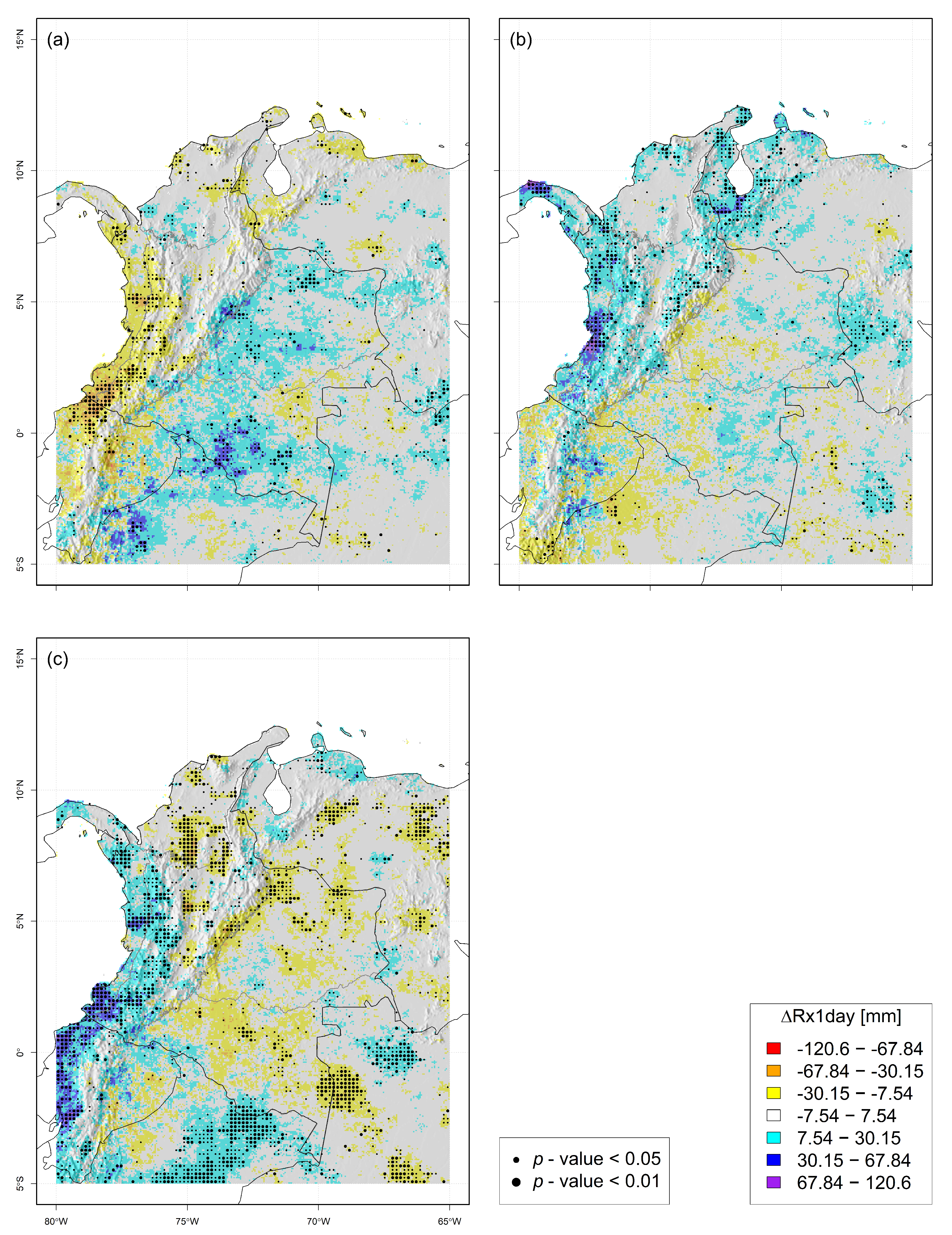
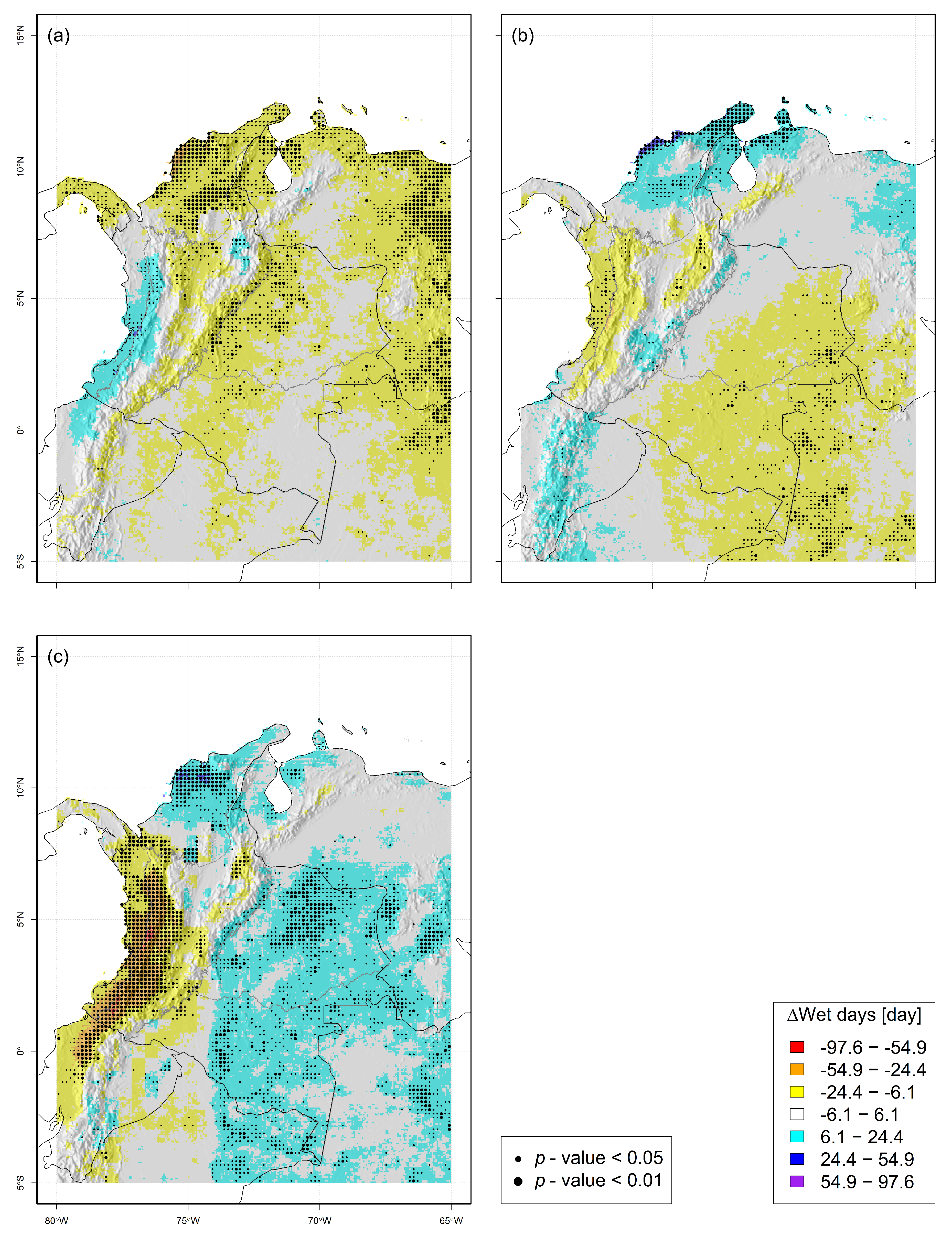
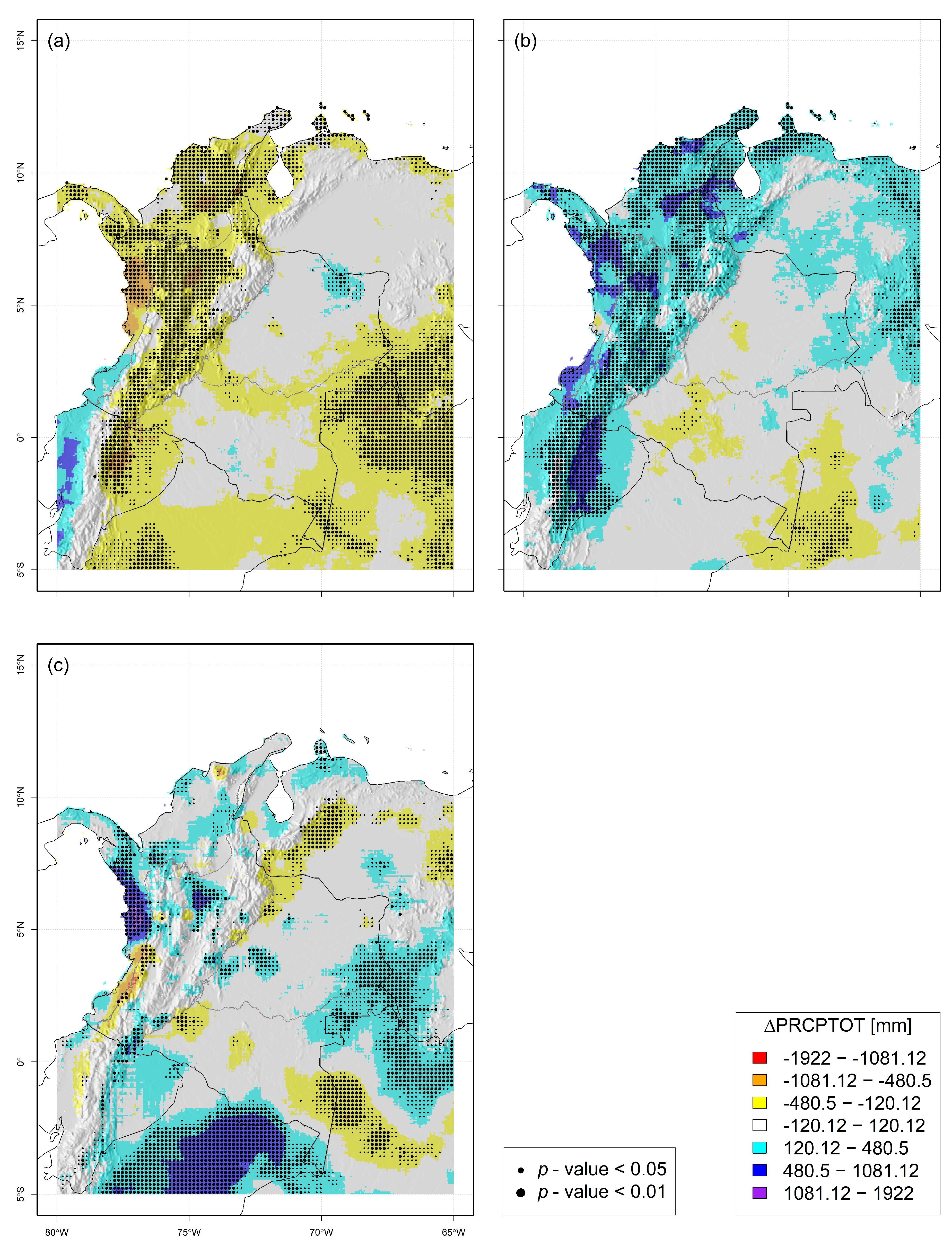
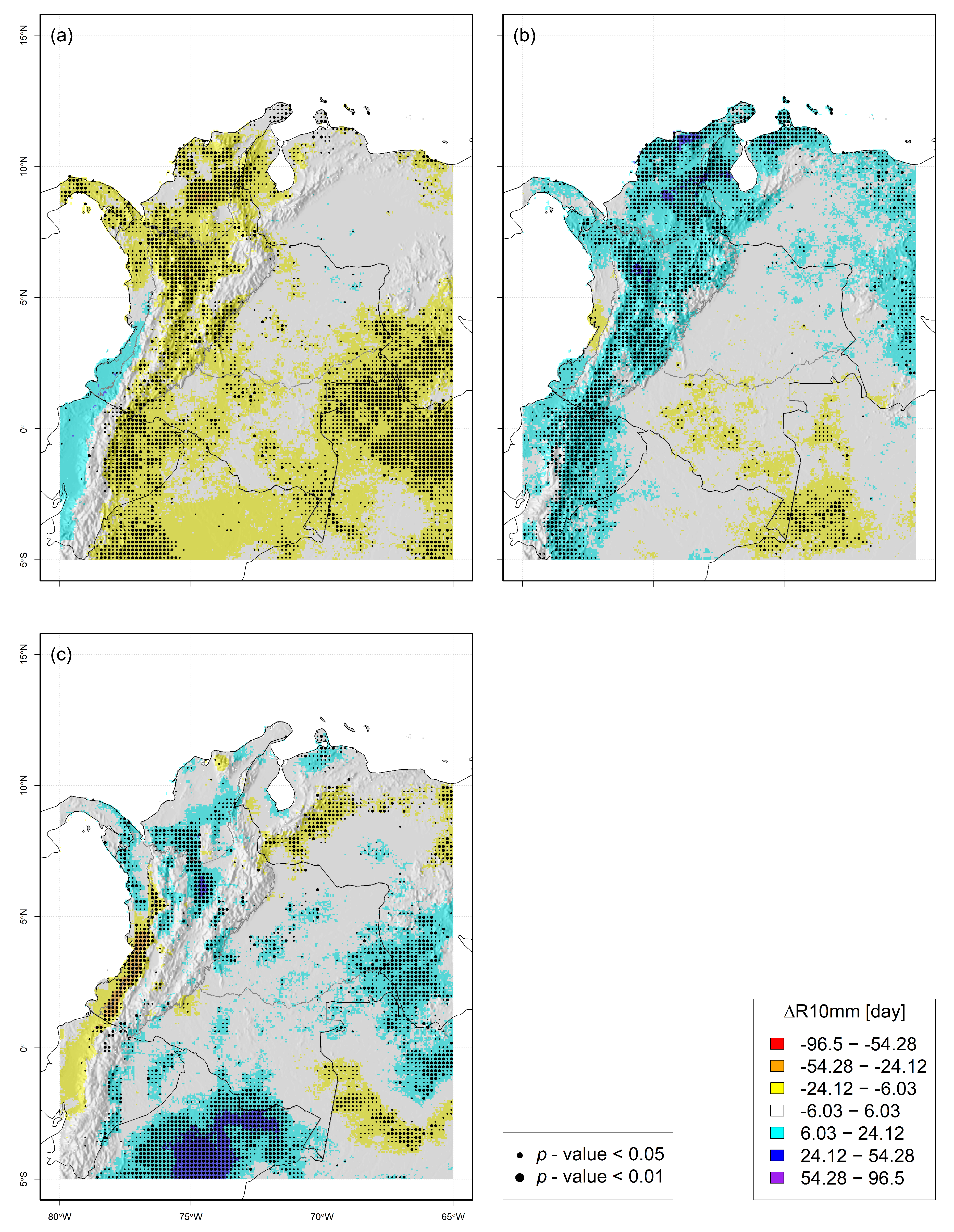
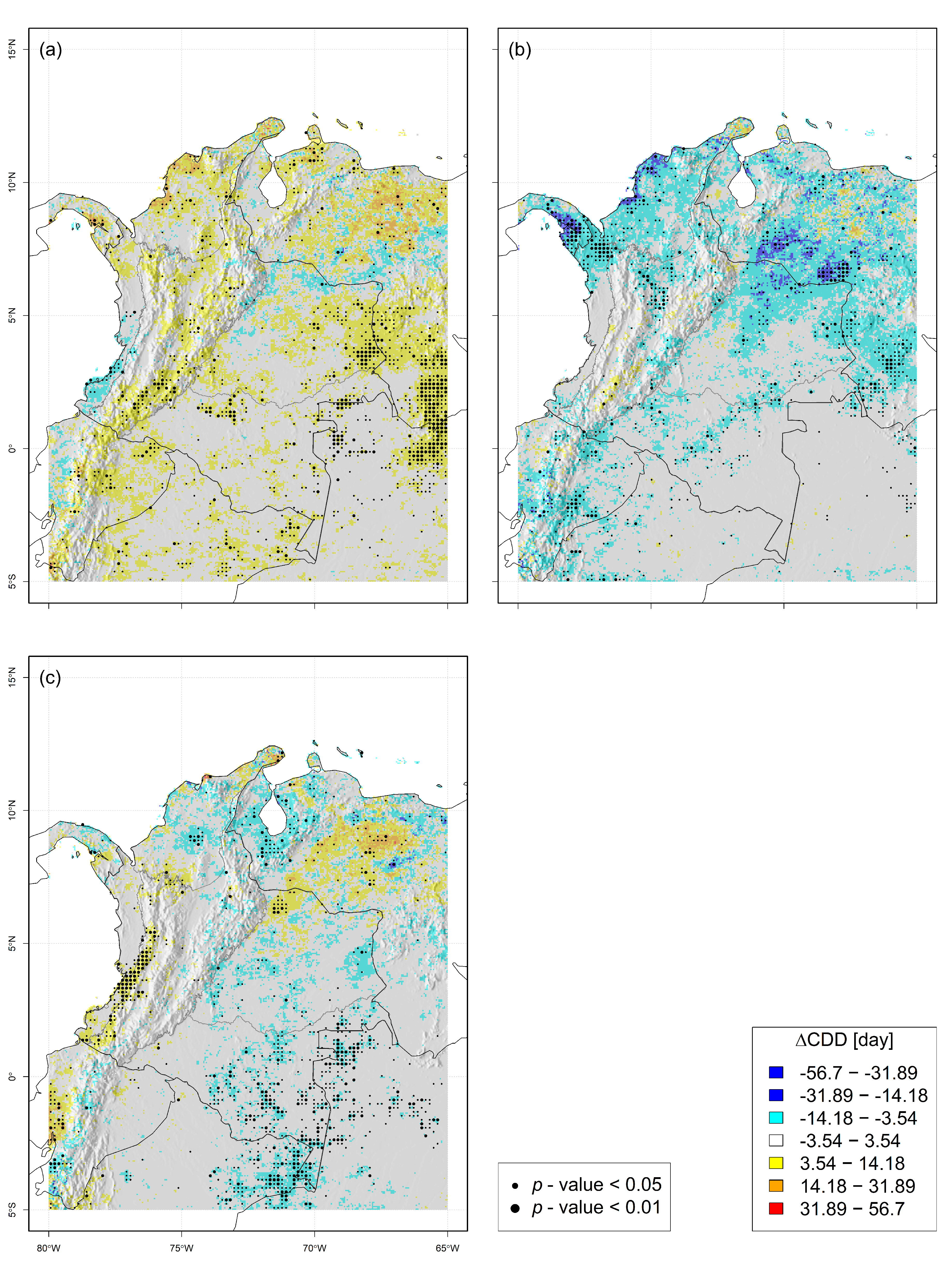
Regarding the Pacific region (PaR), it is observed that, in general, the EPI’s long-term change repeats its trend (i.e., spatial behavior) during La Niña years. This premise is true for EPIs with positive (Rx1day, SDII, and R95pTOT) or negative (Wet days) LTC over the whole region. However, the particular spatial behavior of LTC for PRCPTOT, R10mm, and CDD (which have a positive change located in the northernmost area of PaR, but the rest of the region presents a negative change, or no appreciable trend), is partially repeated by the spatial pattern observed during NAY.
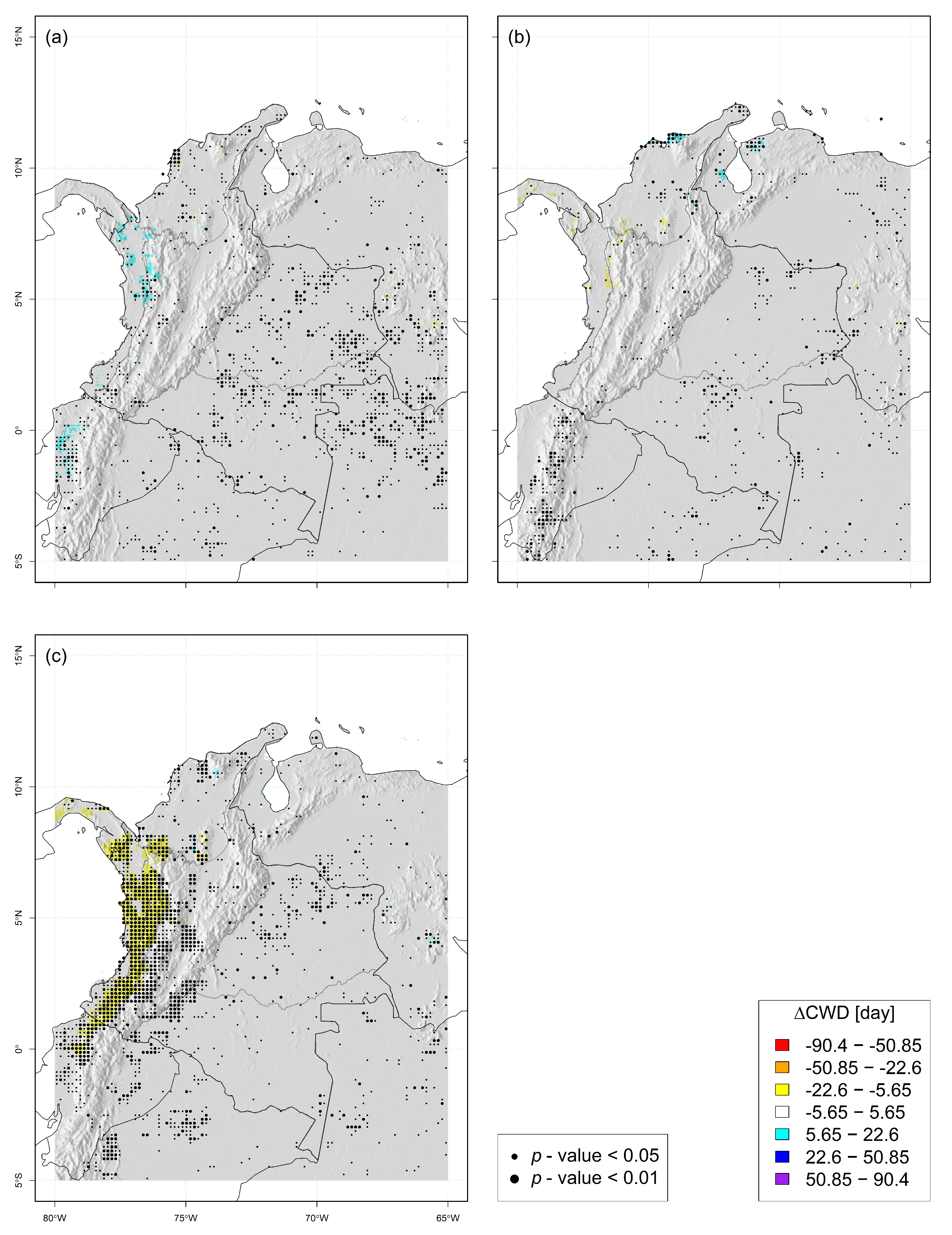
For NOY, several EPIs over PaR tend to present negative anomalies, which suggests less severe extreme precipitation events during these years (especially Rx1day, SDII, PRCPTOT, R10mm, and R95pTOT). Moreover, anomalies during NOY have a spatial behavior opposite to long-term changes. On the other hand, the EPI Wet days presents a slight positive and significant change over the region, which does not coincide with the observed long-term change. Finally, the EPI related to the dry spells (-CDD) and wet spells (CWD) do not present trends during NOY.
It is relevant to remark which of the changes analyzed (i.e., long-term change—LTC, or anomalies due to inter-annual variability—IAV) is the most important for the PaR. This analysis also requires considering each EPI since the importance of the change depends on the one analyzed. Thus, the long-term change was more important for
Wet days,
SDII,
R10mm,
CWD, and
R95pTOT. In
Figure 14, these indices distribution shows the greatest absolute values for
. Also, the LTC distributions for these EPIs are mainly positive or negative, which means spatial coherence of the assessed change. On the other hand, the difference due to inter-annual variability was more important than the long-term one for
PRCPTOT; in
Figure 14, the curves distribution are mainly negative (
) or positive (
), which means more spatial coherence than the LTC. For
Rx1day and
CDD, it is difficult to identify any more critical than the other.
6.2. The Caribbean Region—CaR
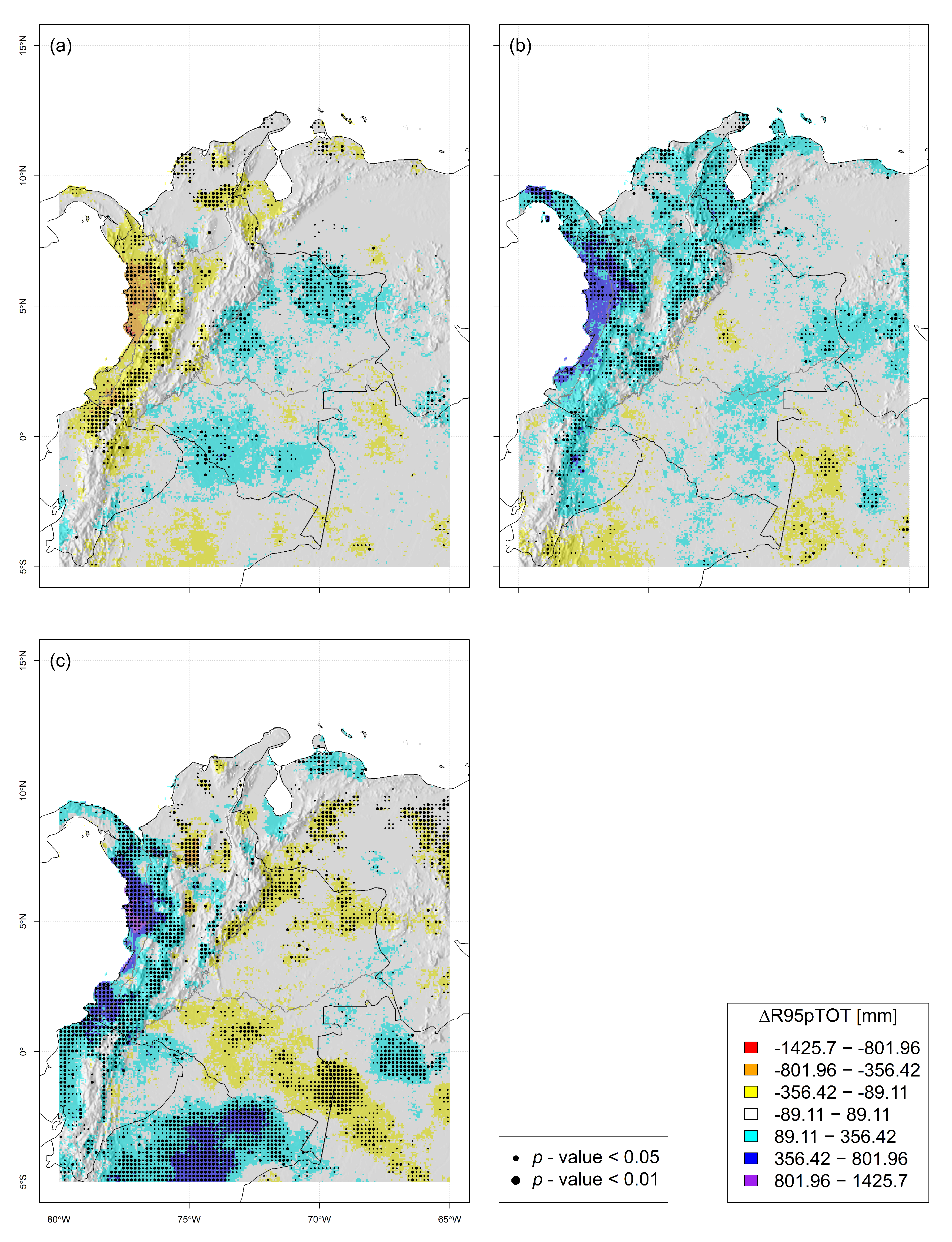
In the Caribbean region (CaR), it is observed that the climatic variability driven by ENSO produces more important shifts in the EPI than those observed in the long term (e.g.,
SDII,
PRCPTOT,
R10mm,
CDD, and
R95pTOT; see
Figure 14). For these EPI, long-term changes are scattered in space, while the anomalies due to climate variability present good spatial coherence: during NOY, these EPI present negative anomalies (i.e., less severe extreme precipitation events), while during NAY, the anomalies are positive (i.e., more severe extremes events during La Niña years).
For EPIs Rx1day and CWD, both climate variability anomalies, and the long-term changes, depict scattered changes over the territory, and neither of them can be classified as the one more important. For Rx1day, LTC tends to be negative (especially at the south CaR), and this spatial distribution is more similar to what is observed for NOY when this EPI tends to have negative anomalies. For CWD, no significant changes are observed due to both long-term and climate variability.
Finally, the EPI
Wet days deserve a detailed analysis because both the long-term change and the anomaly due to climate variability are significant in a large portion of the CaR (see
Figure 14). The long-term change in this region indicates a rise in wet days, gathered at the center of the CaR. This positive change/anomaly is mimicked during NAY, but the area affected during La Niña years is the northernmost of the Caribbean region (i.e., La Guajira peninsula).
6.3. The Andean Region—AnR
In the mountainous region of Colombia, long-term changes are the most important for both Wet days and CWD. For Wet days, there are significant negative LTC to the south of the AnR, while during NOY and NAY, there are negative anomalies that do not have as much spatial coherence as the observed long-term changes. For CWD, negative and significant long-term changes are also presented to the south of the AnR. Still, anomalies due to climate variability (i.e., in NOY or NAY) are not significant in this region for CWD.
The anomaly due to climatic variability is the most important for
PRCPTOT,
R10mm, and
R95pTOT (see
Figure 14). For these EPIs and throughout the region, there are significant negative anomalies during NOY, while significant positive anomalies occur during NAY. For these EPIs, the long-term change presents weak spatial coherence.
Climatic variability anomalies, and long-term changes, have a scattered spatial pattern for Rx1day and CDD. During NAY, this region presents higher values of these EPIs than during NOY; however, these climatic variability anomalies have weak spatial coherence, and positive/negative changes are, in general, not significant. Long-term changes are both spatially dispersed and not significant for both EPIs.
Finally, a detailed analysis deserves the EPI
SDII. There are significant positive changes towards the south of the AnR in the long term. Also, this EPI shows a positive anomaly during NAY, but it is gathered in the north of the AnR. In contrast, the anomaly is negative in the region’s south during NOY. The EPI behavior depicts that, in general, wet days in the mountainous region of Colombia have presented rains of greater intensity due to both the long-term and the climatic variability in NAY. This observation agrees with more extreme precipitation events reported during La Niña years [
28].
6.4. Orinoquia—OrR—and Amazon—AmR—Regions
The eastern plains region of Colombia (the Orinoquia region, plus the Amazon region; OrR + AmR) does not present widespread changes of EPIs, either due to long-term change or due to inter-annual variability. The above statement is true for
Rx1day,
PRCPTOT,
R10mm,
CDD, and
CWD, where none of the trends analyzed (LTC or IAV) is dominant in the region, and there are no large areas with significant positive/negative changes. The changes/anomalies distributions presented in
Figure 14 for these EPIs show quite similar behaviour, which confirm our previous analysis. This behavior agrees with [
61], who said that the connection of the Orinoco river basin climatology with the ENSO is not clear.
The EPI
Wet days presents an LTC that is mainly positive in this region, with significant change patches concentrated on OrR. However, this pattern of change is not replicated by any of the extreme ENSO phases (NOY or NAY; see
Figure 14). The anomalies due to ENSO are mainly negative: for NOY, there are significant negative anomalies over OrR, near the mountainous region (AnR); for NAY, there are negative anomalies far away from the AnR, but they are not significant.
The EPI SDII presents a significant negative LTC on broad areas of the eastern Colombian plains (OrR+AmR). In the same way as the EPI Wet days, this spatial behavior is not replicated during any of the ENSO extreme phases: during NAY, no significant SDII’s anomalies were observed; however, in NOY, significant positive differences were observed throughout the territory.
Finally, R95pTOT exhibits LTC spatial behavior that is not replicated during extreme ENSO phases. The LTC observed for this EPI is mainly negative, with weak spatial coherence. During NAY, R95pTOT does not show significant anomalies. Lastly, observed positive anomalies during NOY do not have strong spatial coherence.
7. Conclusions
In this work, the time evolution of several extreme precipitation indices has been analyzed. The selected study area is the whole Colombian territory.
According to the results, three zones can be identified within the study domain, with observable and discernable behavior of EPIs: (i) The lowlands near the Pacific Ocean to the west (PaR); (ii) The mountainous region embedded in the middle of the country, plus the Caribbean plains to the north (AnR + CaR); and (iii) the eastern plains of the Orinoco-Amazonas basins (AmR + OrR). Long-term changes and anomalies due to inter-annual variability present different performances in these areas.
An excellent example of this disconnected behavior between regions is the EPI PRCPTOT:
As a result, both long-term changes and the anomalies induced by ENSO observed in EPIs indicate that they will be different according to the analyzed region. According to our study, western Colombia (AnR + CaR + PaR) has greater and more significant changes/anomalies due to LTC/IAV than eastern plains (AmR+OrR).
Colombian eastern plains (AmR + OrR) do not show a clear relationship between the EPIs’ value and the IAV driven by ENSO phenomena. Therefore, to investigate the teleconnections of EPIs with other low-frequency macro-climatic phenomena is recommended. Following [
60], those macro-climatic phenomena that affect the dynamics in the Atlantic Ocean, the Caribbean Sea, or the Amazon basin should be analyzed. Finally, the observed LTC in these regions were not significant too.
However, the ENSO-EPI relationship is strong in western Colombia. In general, it is observed that during NOY, there are drier conditions in the country (and, consequently, the EPI values are lower). On the opposite end, during NAY, higher moisture loads are entering mainly from the Pacific Ocean [
65], leading to more severe extreme precipitation events.
Especially for the Pacific region (PaR), the sign of the long-term changes coincides with the anomalies observed during NAY (which is particularly true for Rx1day, SDII, PRCPTOT, and R95pTOT). It may appear that the EPI anomalies observed during any of the ENSO phases (in this particular case, during NAY) will be the conditions of extreme precipitation events in a future climate change scenario. It is a question that should be answered, taking into account the climate change impact on the ENSO phenomenon.
The previous question faces the unpredictability of the intensity and frequency of the extreme phases of the ENSO phenomenon in the future [
25,
66,
67]. Answering this question would require collecting more and better information about EPIs during the ENSO extreme phases, which would allow assessing their behavior during NOY/NAY in length enough time windows.
The primary source of uncertainty in the results is the short length of the CHIRPS record. The study period (hydrological years between 1981 and 2021; forty—40—years) allowed the selection of two short time windows (seventeen—17—years each) to estimate the EPI’s long-term changes. Furthermore, in the same period, only nine (9) NOY were identified, only eight (8) NAY, and twenty-three (23) NOR. These samples are very small, and the results of the MWW test can be debated, at least on the grid points where the significance of the test shows that the statistical evidence is weak.
The aforementioned problem could be partially overcome if several satellite precipitation estimates—SPE—were used. In [
39], six SPE were evaluated (CHIRPS among them) over the Magdalena river basin. Computing EPI from those SPE would allow an ensemble analysis. That analysis would identify areas where the changes are significant and of the same sign on several products. Some areas would have less uncertainty about the change because, for example, all the products agree on the change sign. In the same way, areas of great uncertainty (which may be linked to less significant changes) could be identified if several SPE do not agree on the direction and significance of the change.
Finally, the authors believe that the methodology used in this paper is suitable for monitoring extreme events anomalies driven by low-frequency macroclimatic phenomena, given its robustness even with relatively small samples. The extreme events can be maximum (i.e., the longest drought of the year, the wettest day of the year, etc.) or minimum (i.e., the minimum daily temperature for each year, the minimum recorded surface pressure, etc.) of each year. Then, annual time series of the extreme phenomenon would be built. However, it should be noted that the “hydrological year” does not generally coincide with the “calendar year”.
For example, the macroclimatic phenomenon might have a very low frequency (e.g., the Pacific Decadal Oscillation [
68,
69]). Then, more extended periods could be considered to capture the extreme events (e.g., a value of the extreme event every five years), so that the record of the extreme event follows the natural cycle of the macroclimatic phenomenon. Then, the values for each period would be separated according to some characteristic of the macroclimatic teleconnection, which differentiates its different states. For example, in our work, we use the warm, cold and neutral phases of ENSO to classify the hydrological years.


 ,
, 


