
Assessment of Flood Risk Map under Climate Change RCP8.5 Scenarios in Taiwan


Abstract
:1. Introduction
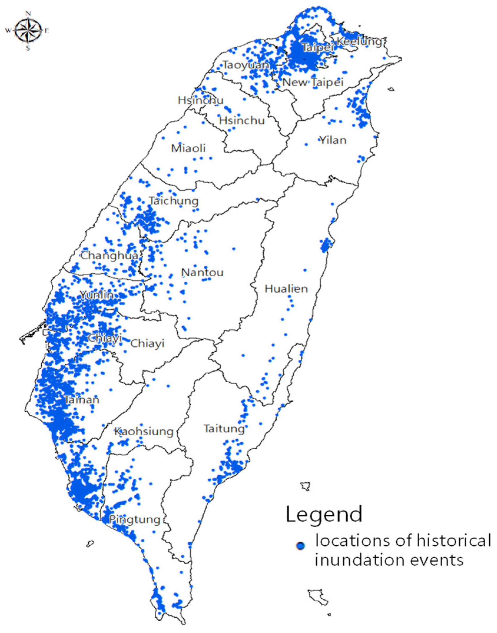
2. Study Area
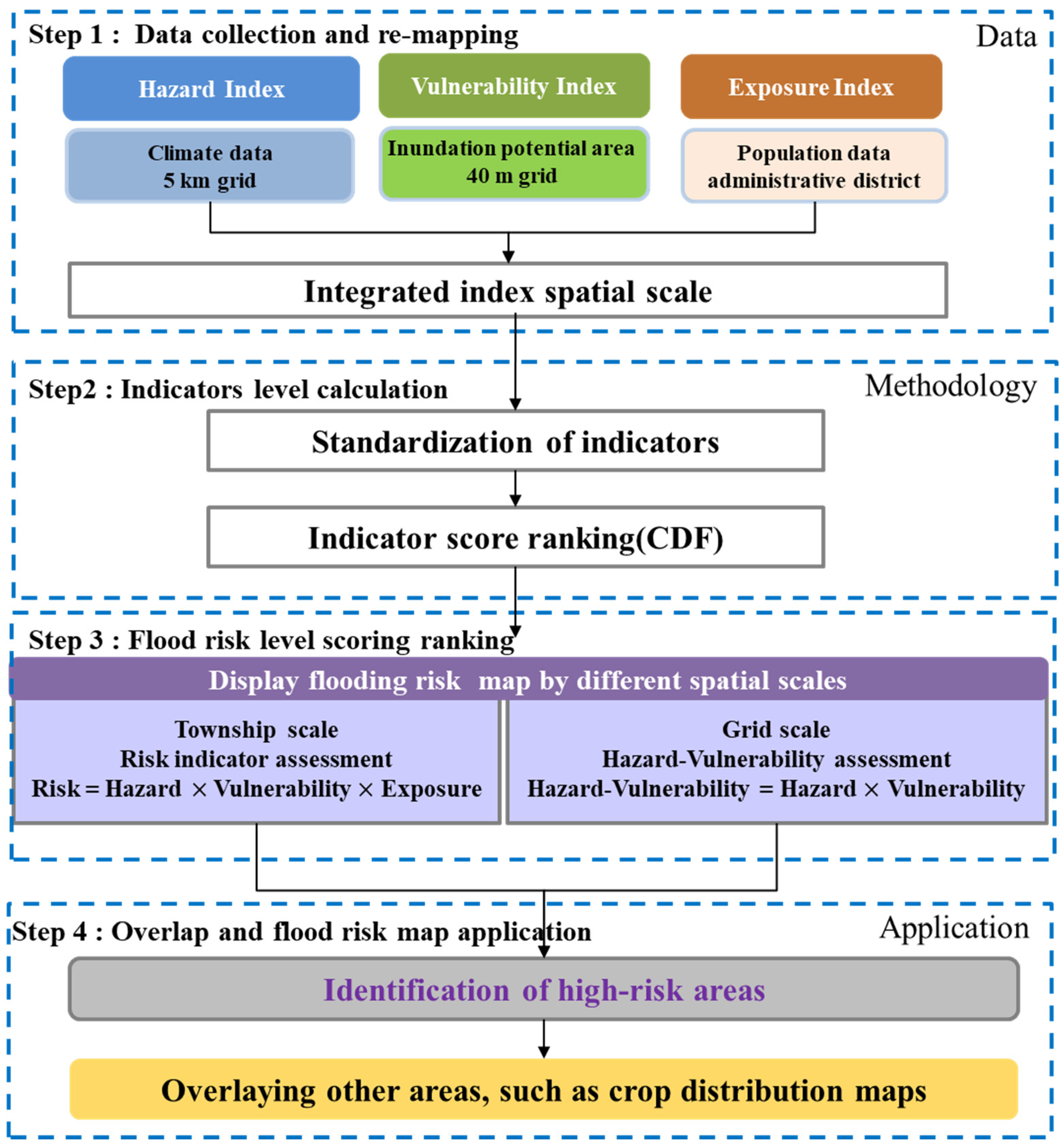
3. Methodology
3.1. Data Collection and Re-Mapping
3.2. Indicators Level Calculation
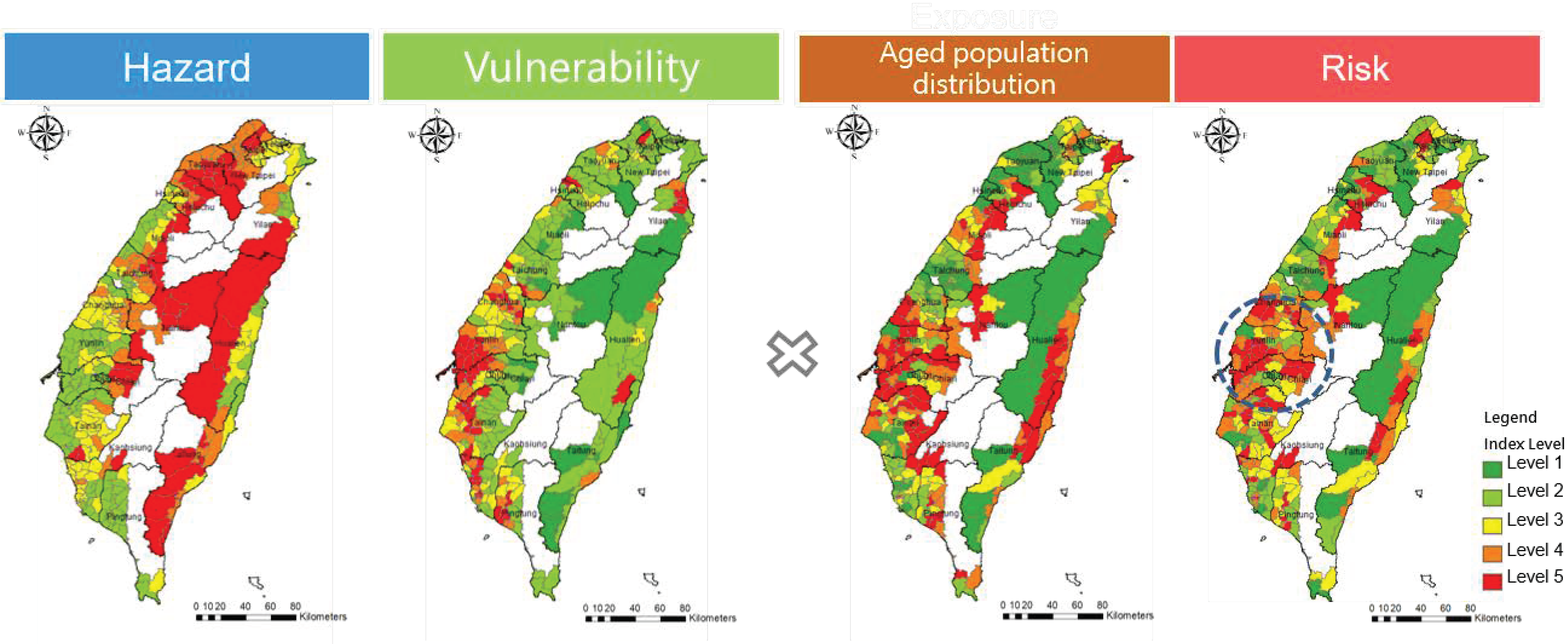
3.2.1. Hazard Component
3.2.2. Vulnerability Component
3.2.3. Exposure Component
3.3. Flood Risk Level and Display
3.4. Application of Flood Risk Maps
4. Results and Discussion
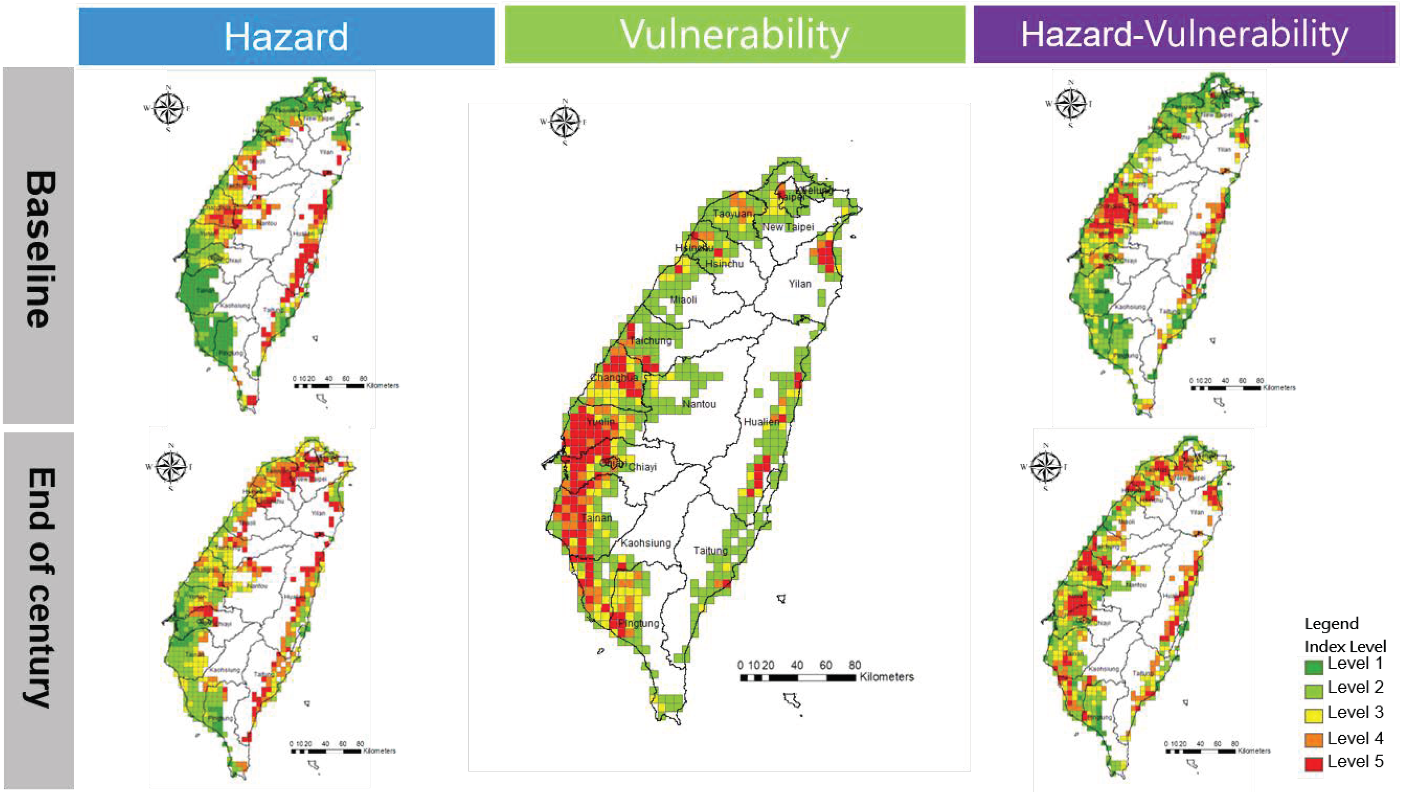
4.1. Flood Risk Maps on Different Scales
4.1.1. Flood H-V Maps
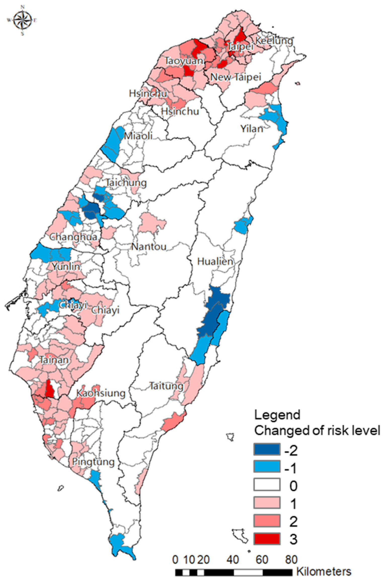
4.1.2. Flood Risk Maps
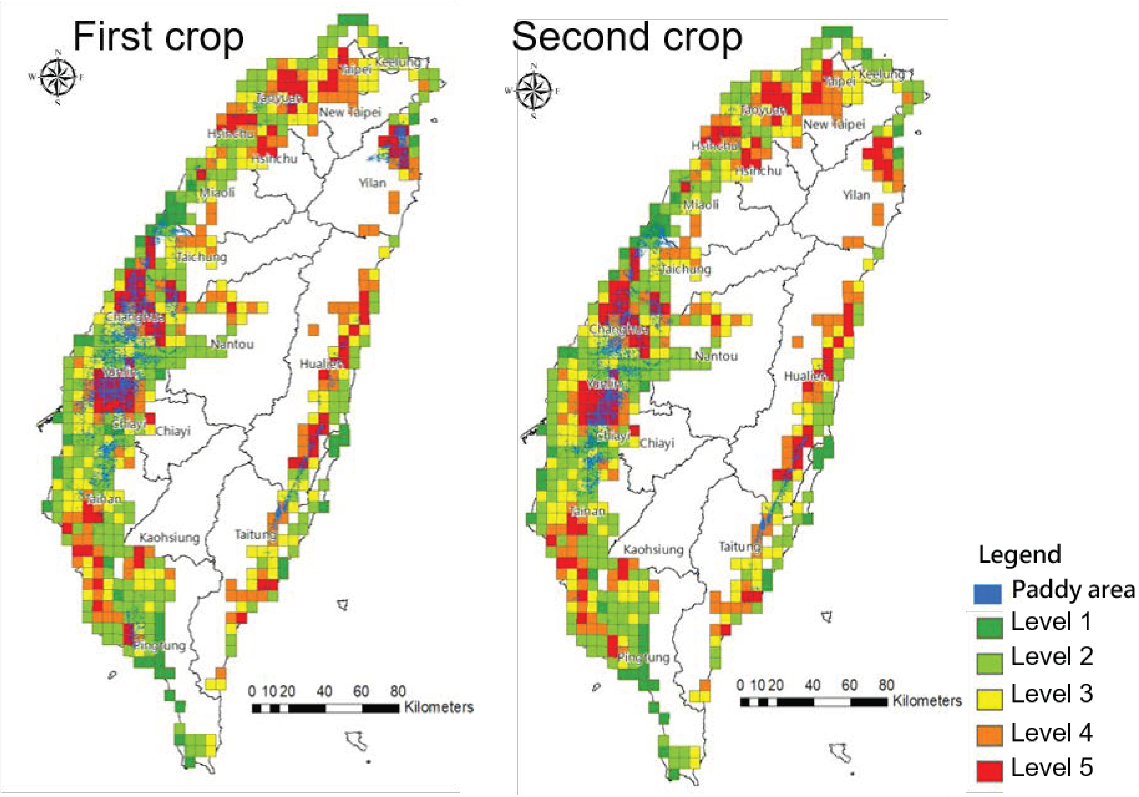
4.2. Application of Food Disaster Risk Map
5. Conclusions and Recommendations
Author Contributions
Funding
Institutional Review Board Statement
Informed Consent Statement
Data Availability Statement
Acknowledgments
Conflicts of Interest
References
- Westra, S.; Alexander, L.V.; Zwiers, F.W. Global increasing trends in annual maximum daily precipitation. J. Clim. 2013, 26, 3904–3918. [Google Scholar] [CrossRef] [Green Version]
- Asadieh, B.; Krakauer, N. Global trends in extreme precipitation: Climate models versus observations. Hydrol. Earth Syst. Sci. 2015, 19, 877–891. [Google Scholar] [CrossRef] [Green Version]
- Wasko, C.; Sharma, A. Global assessment of flood and storm extremes with increased temperatures. Sci. Rep. 2017, 7, 7945. [Google Scholar] [CrossRef] [PubMed]
- Sezen, C.; Šraj, M.; Medved, A.; Bezak, N. Investigation of rain-on-snow floods under climate change. Appl. Sci. 2020, 10, 1242. [Google Scholar] [CrossRef] [Green Version]
- Grip, I.L.; Haghighatafshar, S.; Aspegren, H. A methodology for the assessment of compound sea level and rainfall impact on urban drainage networks in a coastal city under climate change. City Environ. Interact. 2021, 12, 100074. [Google Scholar] [CrossRef]
- Zisopoulou, K.; Panagoulia, D. An In-Depth Analysis of Physical Blue and Green Water Scarcity in Agriculture in Terms of Causes and Events and Perceived Amenability to Economic Interpretation. Water 2021, 13, 1693. [Google Scholar] [CrossRef]
- Efthimiou, N.; Likoudi, E.; Panagoulia, D.; Karavitis, C. Assessment of soil susceptibility to erosion using the EPM and RUSLE models: The case of Venetikos river catchment. Glob. NEST J. 2016, 18, 164–179. [Google Scholar] [CrossRef]
- Hamed, Z.S.; Abudu, S.; Alizadeh, R.; Soltanisehat, L.; Dilekli, N.; King, J.P. Integration of time series forecasting in a dynamic decision support system for multiple reservoir management to conserve water sources. Energy Sources Part A Recovery Util. Environ. Eff. 2018, 40, 1398–1416. [Google Scholar] [CrossRef]
- Acreman, M.; Sinclair, C. Classification of drainage basins according to their physical characteristics; and application for flood frequency analysis in Scotland. J. Hydrol. 1986, 84, 365–380. [Google Scholar] [CrossRef]
- Veijalainen, H.; Lotsari, E.; Alho, P.; Vehviläinen, B.; Käyhkö, J. National scale assessment of climate change impacts on flooding in Finland. J. Hydrol. 2010, 391, 333–350. [Google Scholar] [CrossRef]
- Yan, D.; Werners, S.E.; Ludwig, F.; Huang, H.Q. Hydrological response to climate change: The Pearl River, China under different RCP scenarios. J. Hydrol. 2015, 4, 228–245. [Google Scholar] [CrossRef] [Green Version]
- IPCC. The Fifth Assessment Report of the Intergovernmental Panel on Climate Change; IPCC: Geneva, Switzerland, 2014. [Google Scholar]
- Saldarriaga, J.; Salcedo, C.; Solarte, L.; Pulgarín, L.; Rivera, M.L.; Camacho, M.; Iglesias-Rey, P.L.; Martínez-Solano, F.J.; Cunha, M. Reducing Flood Risk in Changing Environments: Optimal Location and Sizing of Stormwater Tanks Considering Climate Change. Water 2020, 12, 2491. [Google Scholar] [CrossRef]
- Van Kempen, G.; van der Wiel, K.; Melsen, L.A. The impact of hydrological model structure on the simulation of extreme runoff events. Nat. Hazards Earth Syst. Sci. 2021, 21, 961–976. [Google Scholar] [CrossRef]
- Clifton, C.F.; Day, K.T.; Luce, C.H.; Grant, G.E.; Safeeq, M. Effects of climate change on hydrology and water resources in the Blue Mountains, Oregon, USA. Clim. Serv. 2018, 10, 9–19. [Google Scholar] [CrossRef]
- Hallegatte, S.; Green, C.; Nicholls, R.J.; Corfee-Morlot, J. Future flood losses in major coastal cities. Nat. Clim. Chang. 2013, 3, 802–806. [Google Scholar] [CrossRef]
- Jongman, B.; Ward, P.J.; Jeroen, C.J.H.A.J. Global exposure to river and coastal flooding: Long term trends and changes. Glob. Environ. Change Hum. Policy Dimens. 2012, 22, 823–835. [Google Scholar] [CrossRef]
- Alizadeh, R.; Lund, P.D.; Beynaghi, A.; Abolghasemi, M.; Maknoon, R. An integrated scenario-based robust planning approach for foresight and strategic management with application to energy industry. Technol. Forecast. Soc. Change 2016, 104, 162–171. [Google Scholar] [CrossRef]
- United Nations International Strategy for Disaster Reduction (UNISDR). GAR 2013—Global Assessment Report on Disaster Risk Reduction. From Share Risk to Shared Value: The Business Case for Disaster Risk Reduction; UNISDR: Geneva, Switzerland, 2013. [Google Scholar]
- Matheswaran, K.; Alahacoon, N.; Pandey, R.; Giriraj, A. Flood risk assessment in South Asia to prioritize flood index insurance applications in Bihar, India. Geomat. Nat. Hazards Risk 2019, 10, 26–48. [Google Scholar] [CrossRef] [Green Version]
- Gain, A.K.; Mojtahed, V.; Biscaro, C.; Balbi, S.; Giupponi, C. An integrated approach of flood risk assessment in the eastern part of dhaka city. Nat. Hazard 2015, 79, 1499–1530. [Google Scholar] [CrossRef] [Green Version]
- Liu, W.C.; Hsieh, T.H.; Liu, H.M. Flood Risk Assessment in Urban Areas of Southern Taiwan. Sustainability 2021, 13, 3180. [Google Scholar] [CrossRef]
- De Moel, H.; Jongman, B.; Kreibich, H.; Merz, B.; Penning-Rowsell, E.; Ward, P.J. Flood risk assessments at different spatial scales. Mitig. Adapt. Strateg. Glob. Change 2015, 20, 865–890. [Google Scholar] [CrossRef] [PubMed] [Green Version]
- Hadipour, V.; Vafaie, F.; Deilami, K. Coastal Flooding Risk Assessment Using a GIS-Based Spatial Multi-Criteria Decision Analysis Approach. Water 2020, 12, 2379. [Google Scholar] [CrossRef]
- Cai, S.; Fan, J.; Yang, W. Flooding Risk Assessment and Analysis Based on GIS and the TFN-AHP Method: A Case Study of Chongqing, China. Atmosphere 2021, 12, 623. [Google Scholar] [CrossRef]
- Yildirim, E.; Demir, I. An Integrated Flood Risk Assessment and Mitigation Framework: A Case Study for Middle Cedar River Basin, Iowa, USA. Int. J. Disaster Risk Reduct. 2021, 56, 102113. [Google Scholar] [CrossRef]
- Hirabayashi, Y.; Mahendran, R.; Koirala, S.; Konoshima, L.; Yamazaki, D.; Watanabe, S.; Kim, H.; Kanae, S. Global flood risk under climate change. Nat. Clim. Change 2013, 3, 816. [Google Scholar] [CrossRef]
- De Moel, H.; Aerts, J.C.J.H.; Koomen, E. Development of flood exposure in the Netherlands during the 20th and 21th century. Glob. Environ. Change 2011, 21, 620–627. [Google Scholar] [CrossRef]
- Mani, P.; Chatterjee, C.; Kumar, R. Flood hazard assessment with multiparameter approach derived from coupled 1D and 2D hydrodynamic flow model. Nat. Hazards 2014, 70, 1553–1574. [Google Scholar] [CrossRef]
- Bathrellos, G.D.; Karymbalis, E.; Skilodimou, H.D.; Gaki-Papanastassiou, K.; Baltas, E.A. Urban flood hazard assessment in the basin of Athens Metropolitan city, Greece. Environ. Earth Sci. 2016, 75, 319. [Google Scholar] [CrossRef]
- Garrote, J.; Diez-Herrero, A.; Escudero, C.; Garcia, I. A framework proposal for regional-scale flood-risk assessment of cultural heritage sites and application to the Castile and Leon Region (Central Spain). Water 2020, 12, 329. [Google Scholar] [CrossRef] [Green Version]
- Grezo, H.; Mocko, M.; Izsoff, M.; Vrbicanova, G.; Petrovic, F.; Stranak, J.; Muchova, Z.; Slamova, M.; Olah, B.; Machar, I. Flood risk assessment for the long-term strategic planning considering the placement of industrial parks in Slovakia. Sustainability 2020, 12, 4144. [Google Scholar] [CrossRef]
- Marco, J.B. Flood risk Mapping; Rossi, G., Harmancioğl, N., Yevjevic, V., Eds.; Springer: Dordrecht, The Netherlands, 1994. [Google Scholar] [CrossRef]
- Merz, B.; Thieken, A.; Gocht, M. Flood risk mapping at the local scale: Concepts and challenges. In Advances in Natural and Technological Hazards Research; Springer: Dordrecht, The Netherlands, 2007. [Google Scholar] [CrossRef]
- Müller, A.; Reiter, J.; Weiland, U. Assessment of urban vulnerability towards floods using an indicator-based approach—A case study for Santiago de Chile. Nat Hazards Earth Syst Sci. 2011, 11, 2107–2123. [Google Scholar] [CrossRef] [Green Version]
- Kappes, M.S.; Papathoma-Köhle, M.; Keiler, M. Assessing physical vulnerability for multi-hazards using an indicator-based methodology. Appl Geogr. 2012, 32, 577–590. [Google Scholar] [CrossRef]
- Ghanbarpour, M.R.; Salimi, S.; Hipel, K.W. A comparative evaluation of flood mitigation alternatives using GIS-based river hydraulics modelling and multicriteria decision analysis. J Flood Risk Manag. 2013, 6, 319–331. [Google Scholar] [CrossRef]
- Elsheikh, R.; Ouerghi, S.; Elhag, A. Flood Risk Map Based on GIS, and Multi Criteria Techniques (Case Study Terengganu Malaysia). J. Geogr. Inf. Syst. 2015, 7, 348–357. [Google Scholar] [CrossRef] [Green Version]
- Papaioannou, G.; Vasiliades, L.; Loukas, A. Multi-Criteria Analysis Framework for Potential Flood Prone Areas Mapping. Water Resour. Manag. 2015, 29, 399–418. [Google Scholar] [CrossRef]
- Rahmati, O.; Zeinivand, H.; Besharat, M. Flood hazard zoning in Yasooj region, Iran, using GIS and multi-criteria decision analysis. Geomatics, Nat. Hazards Risk 2016, 7, 1000–1017. [Google Scholar] [CrossRef] [Green Version]
- Martínez-Casasnovas, J.A.; Ramos, M.C.; Ribes-Dasi, M. Soil erosion caused by extreme rainfall events: Mapping and quantification in agricultural plots from very detailed digital elevation models. Geoderma 2002, 105, 125–140. [Google Scholar] [CrossRef]
- Veleda, V.; Martínez-Graña, A.M.; Santos-Francés, F.; Sánchez-San Roman, J.; Criado, M. Analysis of the Hazard, Vulnerability, and Exposure to the Risk of Flooding (Alba de Yeltes, Salamanca, Spain). Appl. Sci. 2017, 7, 157. [Google Scholar] [CrossRef] [Green Version]
- Zhang, J.; Xu, W.; Liao, X.; Zong, S.; Liu, B. Global mortality risk assessment from river flooding under climate change. Environ. Res. Lett. 2021, 16, 064036. [Google Scholar] [CrossRef]
- Arabameri, A.; Rezaei, K.; Cerda, A.; Conoscenti, C.; Kalantari, Z. A comparison of statistical methods and multi-criteria decision making to map flood hazard susceptibility in Northern Iran. Sci. Total Environ. 2019, 660, 443–458. [Google Scholar] [CrossRef]
- Cabrera, J.S.; Lee, H.S. Flood-prone area assessment using GIS-based multi-criteria analysis: A case study in Davao Oriental, Philippines. Water 2019, 11, 2203. [Google Scholar] [CrossRef] [Green Version]
- Chakraborty, S.; Mukhopadhyay, S. Assessing flood risk using analytical hierarchy process (AHP) and geographical information system (GIS): Application in Coochbehar district of West Bengal, India. Nat. Hazards 2019, 99, 247–274. [Google Scholar] [CrossRef]
- Toosi, A.S.; Calbimonte, G.H.; Nouri, H.; Alaghmand, S. River basin-scale flood hazard assessment using a modified multi-criteria decision analysis approach: A case study. J. Hydrol. 2019, 574, 660–671. [Google Scholar] [CrossRef]
- IPCC. Managing the Risks of Extreme Events and Disasters to Advance Climate Change Adaptation (SREX) Summary for Policy Makers; Cambridge University Press: Cambridge, UK; New York, NY, USA, 2012; 582 p. [Google Scholar]
- Roble, R.G.; Ridley, E.C. A thermosphere-ionosphere-mesosphere-electrodynamics general circulation model (TIME-GCM): Equinox solar cycle minimum simulations (30–500 km). Geophys. Res. Lett. 1994, 21, 417–420. [Google Scholar] [CrossRef]
- Lenderink, G.; Buishand, A.; Deursen, W.V. Estimates of future discharges of the river Rhine using two scenario methodologies: Direct versus delta approach. Hydrol. Earth Syst. Sci. 2007, 11, 1145–1159. [Google Scholar] [CrossRef]
- Huang, H.; Cui, H.; Ge, Q. Assessment of potential risks induced by increasing extreme precipitation under climate change. Nat. Hazards 2021, 108, 2059–2079. [Google Scholar] [CrossRef]
- Janizadeh, S.; Pal, S.; Saha, A.; Chowdhuri, I.; Ahmadi, K.; Mirzaei, S.; Mosavi, A.; Tiefenbacher, J. Mapping the spatial and temporal variability of flood hazard affected by climate and land-use changes in the future. J. Environ. Manag. 2021, 298, 113551. [Google Scholar] [CrossRef]
- Mizuta, R.; Yoshimura, H.; Murakami, H.; Matsueda, M.; Endo, H.; Ose, T.; Kamiguchi, K.; Hosaka, M.; Sugi, M.; Yukimoto, S.; et al. Climate simulations using MRI-AGCM3.2 with 20-km grid. J. Meteorol. Soc. Jpn. 2012, 90, 233–258. [Google Scholar] [CrossRef] [Green Version]
- Su, Y.F.; Cheng, C.T.; Liou, J.J.; Chen, Y.M. Bias correction of MRI-WRF dynamic downscaling datasets. Terr. Atmos. Ocean. Sci. 2016, 27, 649–657. [Google Scholar] [CrossRef] [Green Version]
- Water Resources Agency (WRA). Flood Potential Maps in Taiwan. Available online: http://103.253.146.123/wra/riskmap-dev/flood/ (accessed on 23 November 2021). (In Chinese).
- National Science and Technology Center for Disaster Reduction (NCDR). Disaster Potential Maps in Taiwan. Available online: https://dmap.ncdr.nat.gov.tw/ (accessed on 23 November 2021). (In Chinese)
- Liu, S.C.; Fu, C.; Shiu, C.J.; Chen, J.P.; Wu, F. Temperature dependence of global precipitation extremes. Geophys. Res. Lett. 2009, 36, L17702. [Google Scholar] [CrossRef] [Green Version]
- Su, S.H.; Kuo, H.C.; Hsu, L.H.; Yang, Y.T. Temporal and Spatial Characteristics of Typhoon Extreme Rainfall in Taiwan. J. Meteorol. Soc. Jpn. 2012, 90, 721–736. [Google Scholar] [CrossRef] [Green Version]
- Henny, L.; Thorncroft, C.D.; Hsu, H.H.; Bosart, L.F. Extreme Rainfall in Taiwan: Seasonal Statistics and Trends. J. Clim. 2021, 34, 4711–4731. [Google Scholar] [CrossRef]
- Chen, Y.M.; Chen, C.W.; Chao, Y.C.; Tung, Y.S.; Liou, J.J.; Li, H.C.; Cheng, C.T. Future Landslide Characteristic Assessment Using Ensemble Climate Change Scenarios: A Case Study in Taiwan. Water 2020, 12, 564. [Google Scholar] [CrossRef] [Green Version]
- Wei, H.P.; Yeh, K.C.; Liou, J.J.; Chen, Y.M.; Cheng, C.T. Estimating the Risk of River Flow under Climate Change in the Tsengwen River Basin. Water 2016, 8, 81. [Google Scholar] [CrossRef] [Green Version]
- Lee, T.L.; Chen, C.H.; Pai, T.Y.; Wu, R.S. Development of a Meteorological Risk Map for Disaster Mitigation and Management in the Chishan Basin, Taiwan. Sustainability 2015, 7, 962–987. [Google Scholar] [CrossRef] [Green Version]
- Huang, W.P.; Hsu, J.C.; Chen, C.S.; Ye, C.J. The Study of the Coastal Management Criteria Based on Risk Assessment: A Case Study on Yunlin Coast, Taiwan. Water 2018, 10, 988. [Google Scholar] [CrossRef] [Green Version]
- Hsu, T.W.; Shih, D.S.; Li, C.Y.; Lan, Y.J.; Lin, Y.C. A Study on Coastal Flooding and Risk Assessment under Climate Change in the Mid-Western Coast of Taiwan. Water 2017, 9, 390. [Google Scholar] [CrossRef]
- Water Resources Agency (WRA). 2018 Renew and Development of Decision-making Support Services for Flood Risk Maps; Water Resources Agency: Taichung, Taiwan, 2018; pp. 93–148. (In Chinese) [Google Scholar]
- Chen, Y.R.; Yeh, C.H.; Yu, B. Integrated application of the analytic hierarchy process and the geographic information system for flood risk assessment and flood plain management in Taiwan. Nat. Hazards 2011, 59, 1261–1276. [Google Scholar] [CrossRef] [Green Version]
- Hsu, W.K.; Huang, P.C.; Chang, C.C.; Chen, C.W.; Hung, D.M.; Chiang, W.L. An integrated flood risk assessment model for property insurance industry in Taiwan. Nat. Hazards 2011, 58, 1295–1309. [Google Scholar] [CrossRef]
- Weis, S.W.M.; Agostini, V.N.; Roth, L.M.; Gilmer, B.; Schill, S.R.; Knowles, J.E.; Blyther, R. Assessing vulnerability: An integrated approach for mapping adaptive capacity, sensitivity, and exposure. Clim. Change 2016, 136, 615–629. [Google Scholar] [CrossRef] [Green Version]
- Poulos, H.M. Spatially explicit mapping of hurricane risk in New England, USA using ArcGIS. Nat. Hazards 2010, 54, 1015–1023. [Google Scholar] [CrossRef]
- Romali, N.S.; Yusop, Z.; Ismail, A.Z. Application of HEC-RAS and Arc GIS for floodplain mapping in Segamat town, Malaysia. Int. J. GEOMATE 2018, 14, 125–131. [Google Scholar] [CrossRef]
- Inanloo, B.; Tansel, B.; Shams, K.; Jin, X.; Gan, A. A decision aid GIS-based risk assessment and vulnerability analysis approach for transportation and pipeline networks. Saf. Sci. 2016, 84, 57–66. [Google Scholar] [CrossRef]
- Kron, W. Flood Risk = Hazard × Exposure × Vulnerability; Science Press: New York, NY, USA, 2002; pp. 58–68. [Google Scholar] [CrossRef]
- De Moel, H.; van Alphen, J.; Aerts, J. Flood maps in Europe–methods, availability and use. Nat. Hazards Earth Syst. Sci. 2009, 9, 289–301. [Google Scholar] [CrossRef] [Green Version]
- Water Resources Bureau of the Ministry of Economic Affairs. Handbook of Hydrological Design in Taiwan; Water Resources Bureau of the Ministry of Economic Affairs: Taipei, Taiwan, 2001; pp. 7–11. (In Chinese) [Google Scholar]
- Wallis, J.R. Just a Moment. Water Resour. Res. 1974, 10, 211–219. [Google Scholar] [CrossRef] [Green Version]
- Doong, D.J.; Lo, W.; Vojinovic, Z.; Lee, W.L.; Lee, S.P. Development of a New Generation of Flood Inundation Maps—A Case Study of the Coastal City of Tainan, Taiwan. Water 2016, 8, 521. [Google Scholar] [CrossRef] [Green Version]
- Ministry of the Interior, Socio-Economic Database Common Platform. Available online: https://segis.moi.gov.tw/STAT/Web/Portal/GroupProfile/STAT_GroupProfileSTATClass.aspx (accessed on 23 November 2021). (In Chinese)


| Category of Risk | Changes of Risk Level | Percentage of the Numbers of Township |
|---|---|---|
| High risk level | Unchanged at high risk level (still at level 4 or level 5) | 6% |
| Changed to high risk level in the future (from low level to higher level) | 8% | |
| Increased three risk levels (from low level to higher) | 3% | |
| Decreased one risk level (from level 5 to level 4) | 1% | |
| Low risk level | Increased one level (from risk level 1 to level 2) | 9% |
| Unchanged low risk level (still at level 1 or level 2) | 39% | |
| Changed to low risk level in the future (from higher level to low level) | 2% | |
| Reduction of risk level (decreased 1 level) | 8% |
Publisher’s Note: MDPI stays neutral with regard to jurisdictional claims in published maps and institutional affiliations. |
© 2022 by the authors. Licensee MDPI, Basel, Switzerland. This article is an open access article distributed under the terms and conditions of the Creative Commons Attribution (CC BY) license (https://creativecommons.org/licenses/by/4.0/).
Share and Cite
Chen, Y.-J.; Lin, H.-J.; Liou, J.-J.; Cheng, C.-T.; Chen, Y.-M. Assessment of Flood Risk Map under Climate Change RCP8.5 Scenarios in Taiwan. Water 2022, 14, 207. https://doi.org/10.3390/w14020207
Chen Y-J, Lin H-J, Liou J-J, Cheng C-T, Chen Y-M. Assessment of Flood Risk Map under Climate Change RCP8.5 Scenarios in Taiwan. Water. 2022; 14(2):207. https://doi.org/10.3390/w14020207
Chicago/Turabian StyleChen, Yun-Ju, Hsuan-Ju Lin, Jun-Jih Liou, Chao-Tzuen Cheng, and Yung-Ming Chen. 2022. "Assessment of Flood Risk Map under Climate Change RCP8.5 Scenarios in Taiwan" Water 14, no. 2: 207. https://doi.org/10.3390/w14020207
APA StyleChen, Y.-J., Lin, H.-J., Liou, J.-J., Cheng, C.-T., & Chen, Y.-M. (2022). Assessment of Flood Risk Map under Climate Change RCP8.5 Scenarios in Taiwan. Water, 14(2), 207. https://doi.org/10.3390/w14020207