
Combined Application of Hydrogeological and Geoelectrical Study in Groundwater Exploration in Karst-Granite Areas, Jiangxi Province


Abstract
:1. Introduction
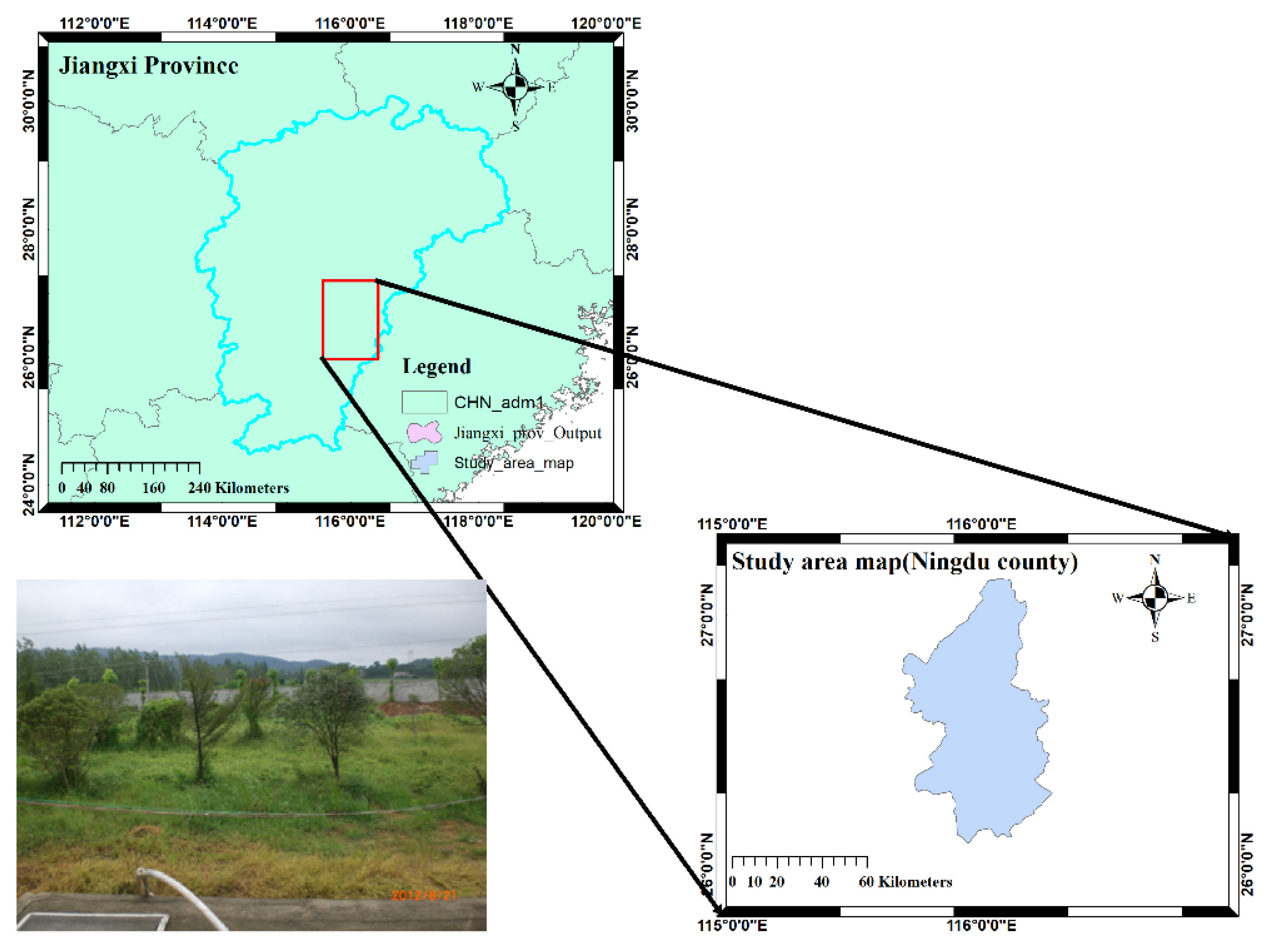
2. Study Area Overview
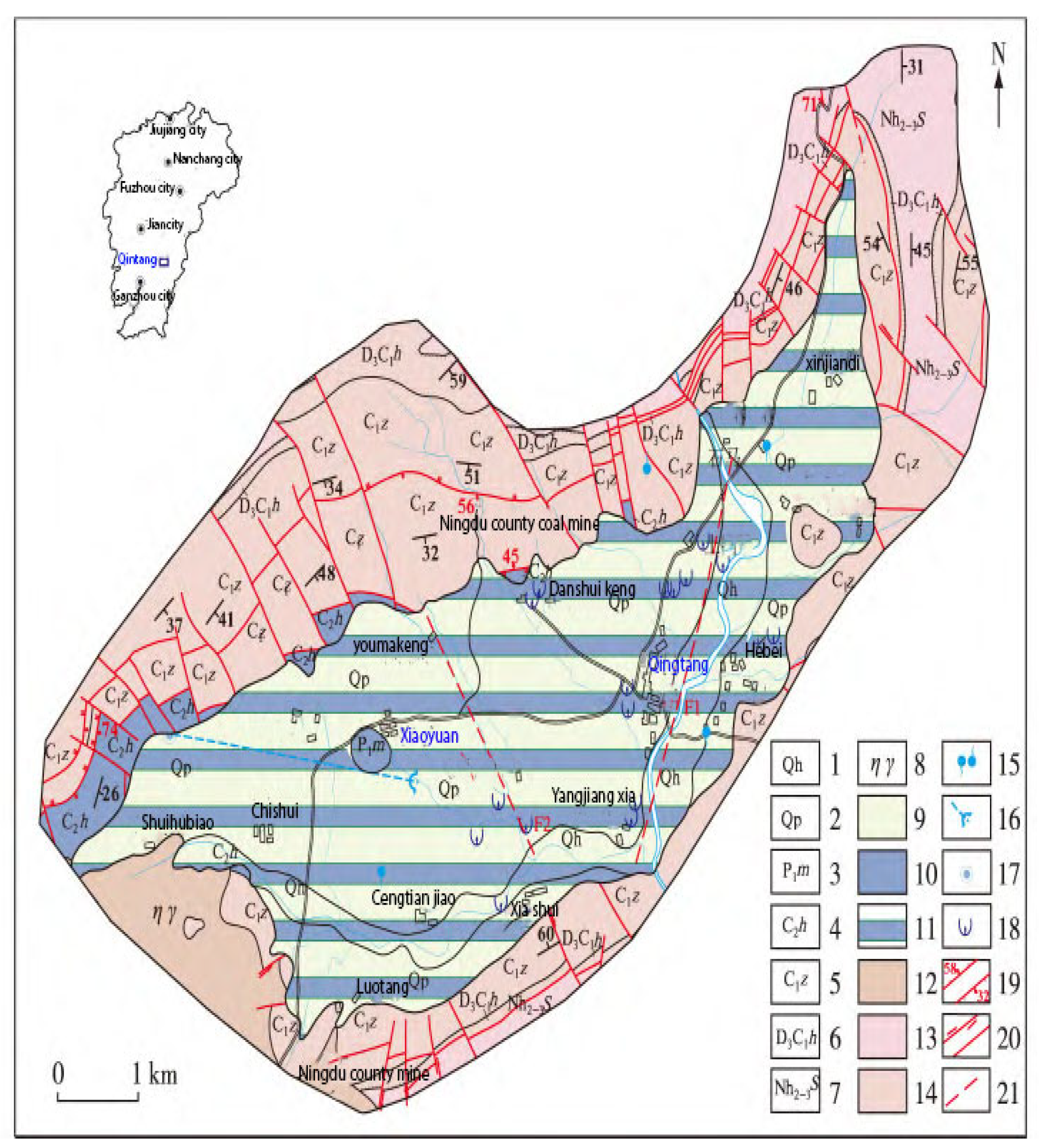
2.1. Geomorphological and Geological Settings
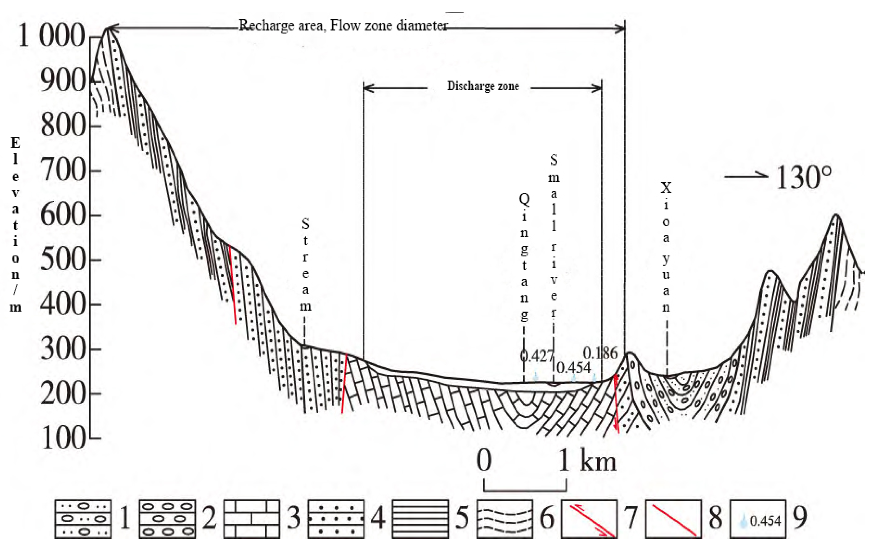
2.2. Regional Hydrogeological Background
3. Methods and Techniques for Groundwater Exploration
3.1. Hydrogeological Survey
3.2. Geophysical Survey
3.2.1. Geophysical Characteristics
3.2.2. Determining Geophysical Methods and Working Parameters
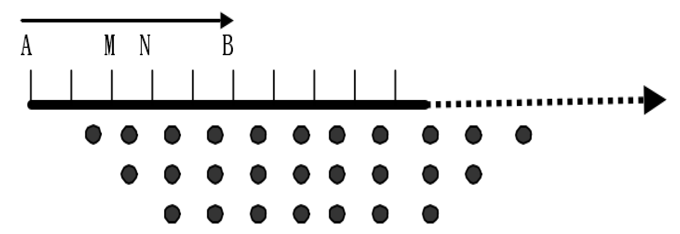
3.3. Data Processing and Data Interpretation Methods
4. Analysis of Geophysical Results and Discussion
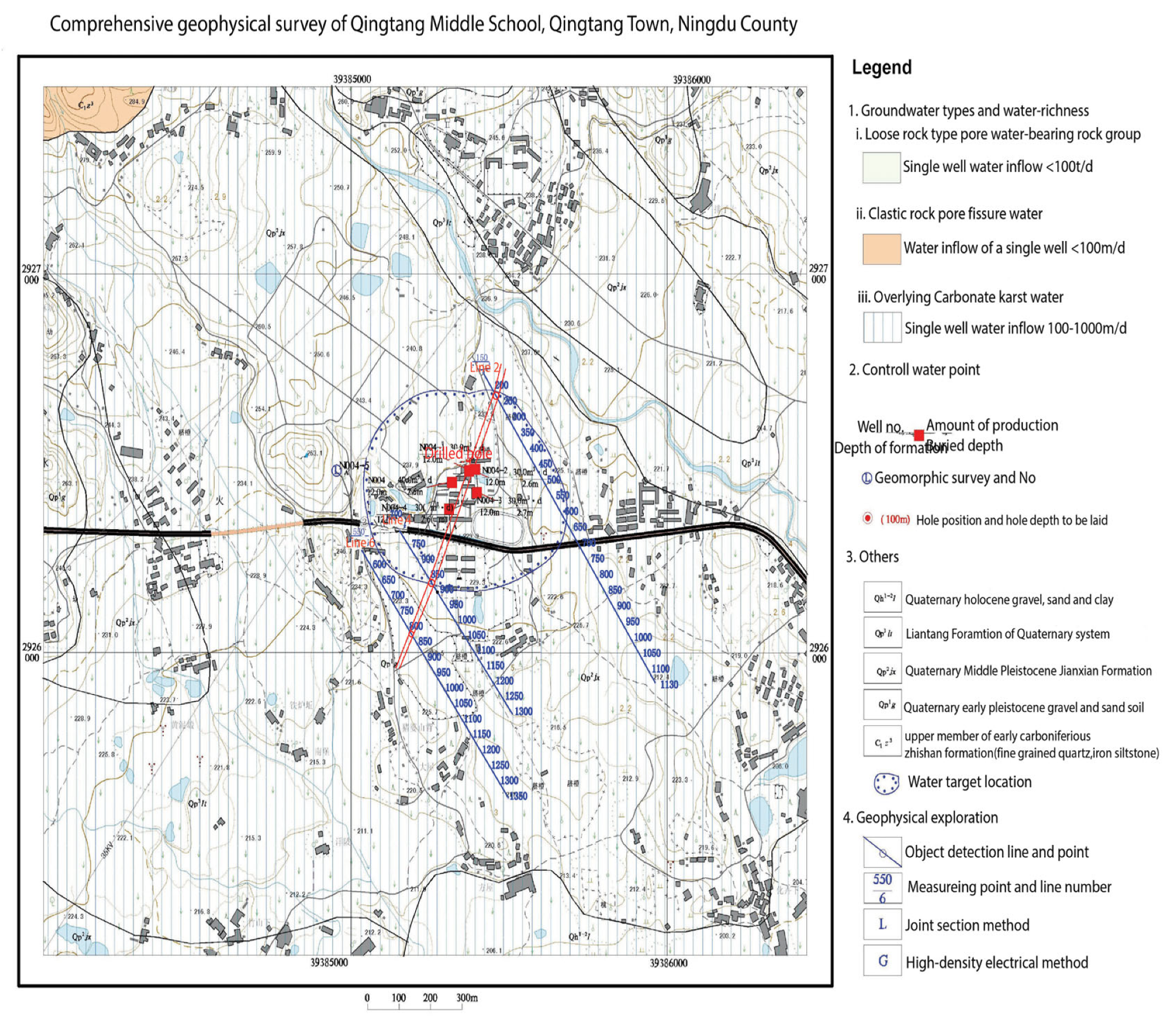
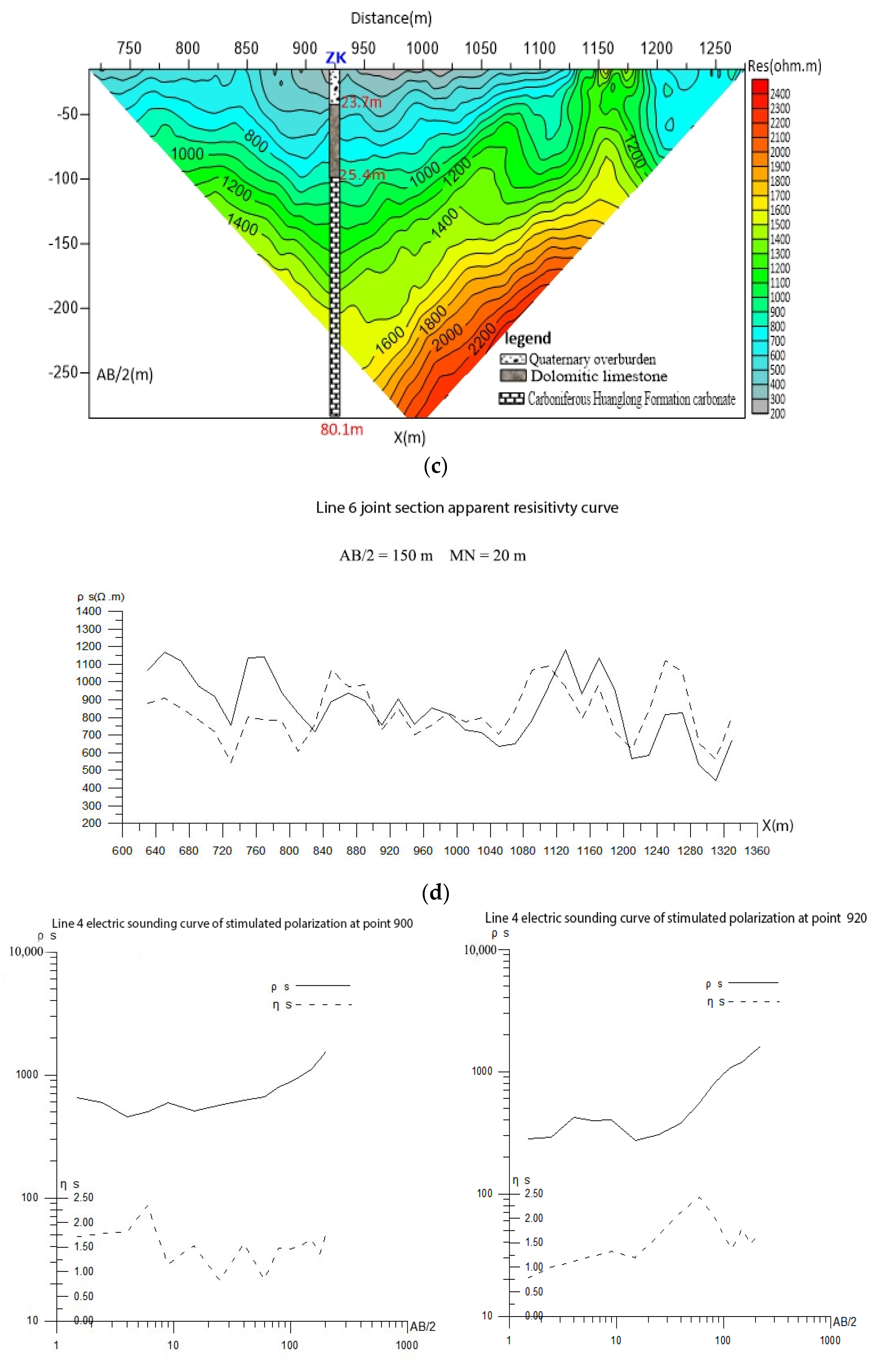
4.1. Qingtang Middle School
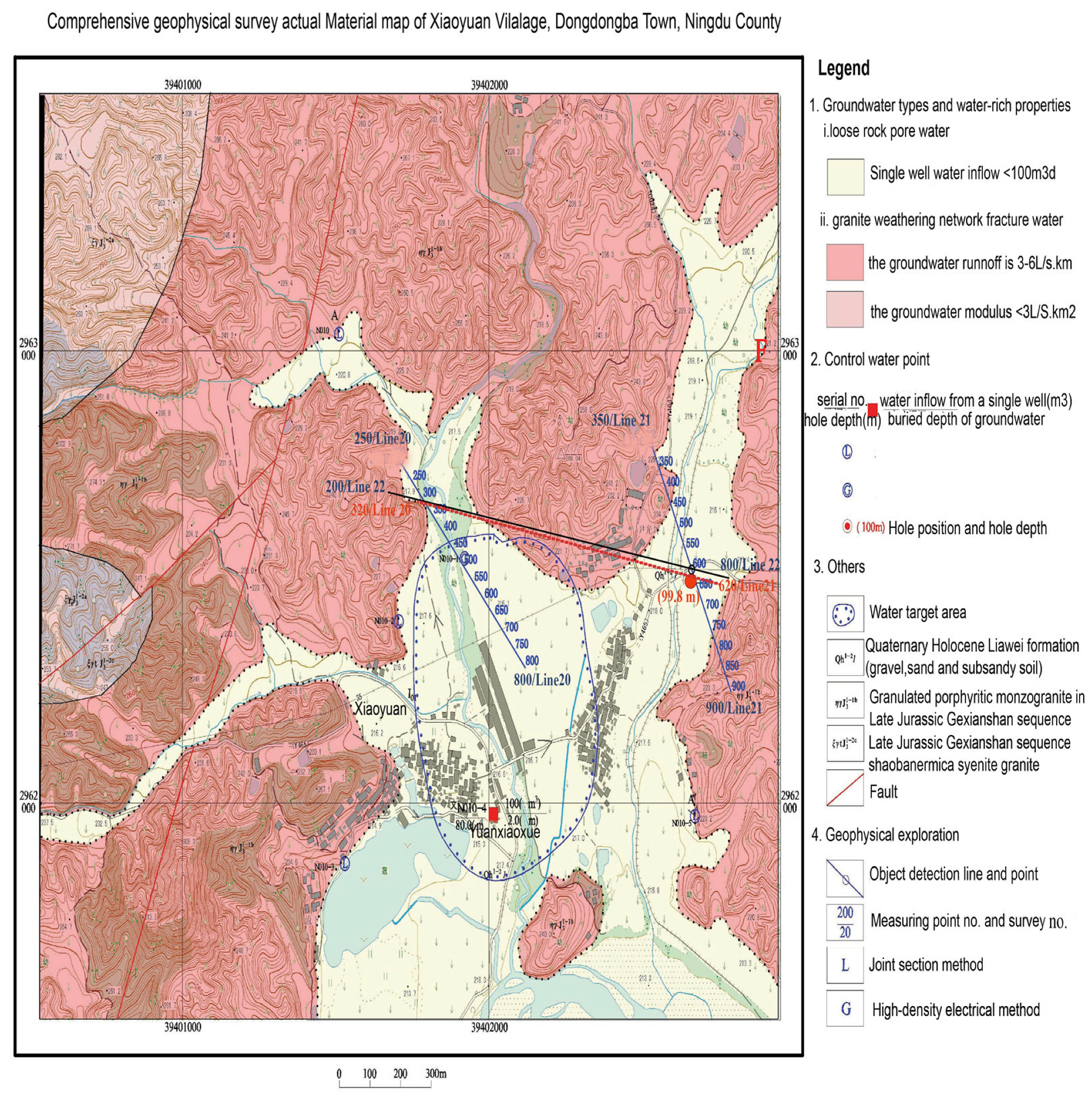
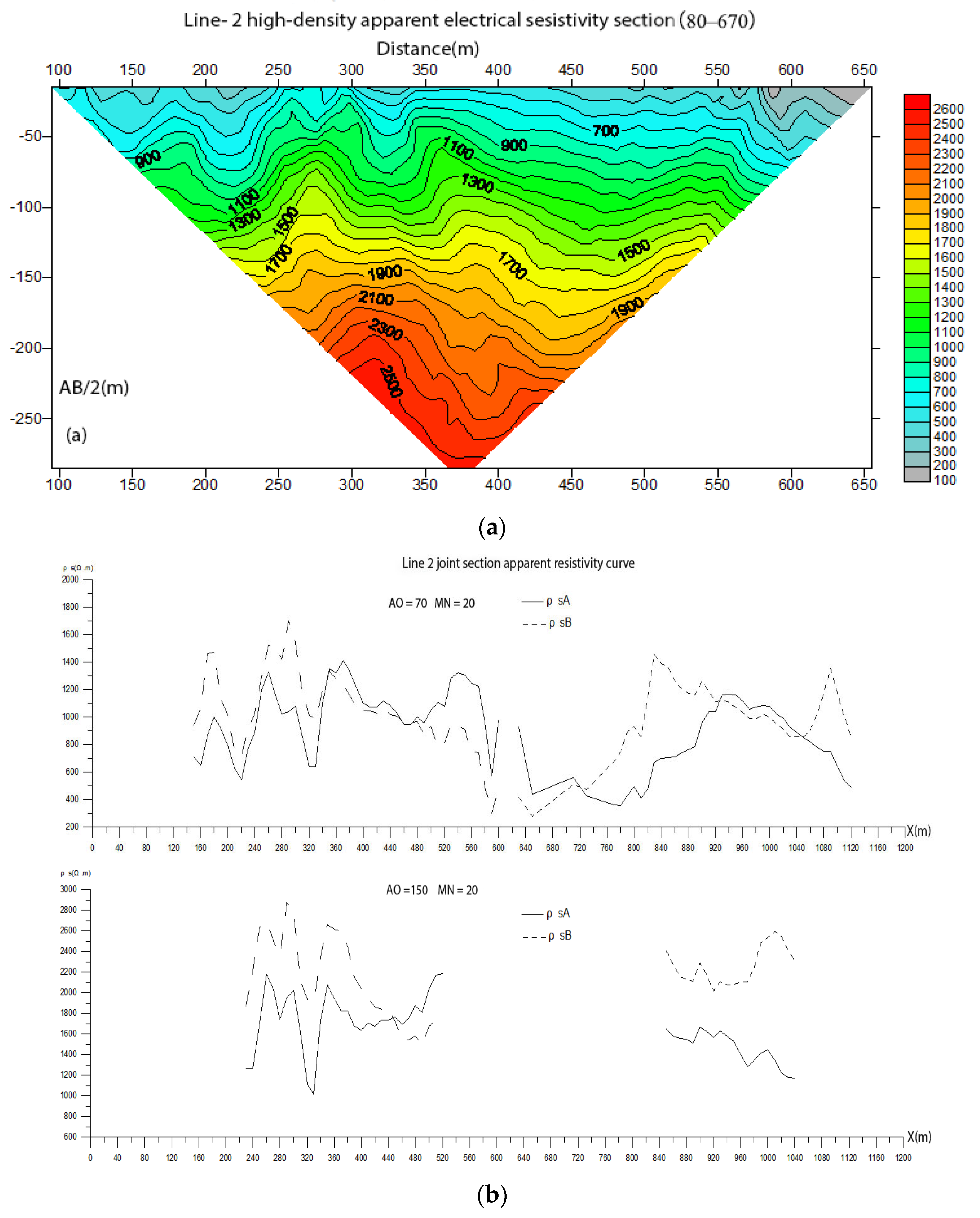
4.2. Xiaoyuan Village
5. Drilling Verification
5.1. Qingtang Middle School in Qingtang Town
5.2. Xiaoyuan Village, Dongshanba Town
5.3. Groundwater Assessment
Hydraulic Parameters and Pumping Test
Qintang Middle School and Xiaoyuan Village
6. Conclusions
Author Contributions
Funding
Data Availability Statement
Conflicts of Interest
References
- Huang, C.; Zhou, Y.; Zhang, S.; Wang, J.; Liu, F.; Gong, C.; Yi, C.; Li, L.; Zhou, H.; Wei, L. Groundwater resources in the Yangtze River Basin and its current development and utilization. Geol. China 2021, 48, 979–1000. [Google Scholar]
- El Osta, M.; El Sheikh, A.E.; Barseem, M. Comparative hydrological and geoelectrical study on the quaternary aquifer in the deltas of Wadi Badaa and Ghweiba, El Ain El Sukhna Area, Northwest Suez Gulf, Egypt. Int. J. Geophys. 2010, 2010, 585243. [Google Scholar]
- Zhang, S.; Jiang, P.; Lu, L.; Wang, S.; Wang, H. Evaluation of Compressive Geophysical Prospecting Method for the Identification of the Abandoned Goaf at the Tengzhou Section of China’s Mu Shi Expressway. Sustainability 2022, 14, 13785. [Google Scholar] [CrossRef]
- Zhou, Y.; Jianwei, P.; Hao, L.; Zhongmei, W.; Jiang, Z.; Haixin, L.; Jiaxu, L. Multi-turn small-loop transient electromagnetic data processing using constraints from borehole and electrical resistivity tomography data. Arab. J. Geosci. 2022, 15, 1675. [Google Scholar] [CrossRef]
- Sener, E.; Davraz, A.; Ozcelik, M. An integration of GIS and remote sensing in groundwater investigations: A case study in Burdur, Turkey. Hydrogeol. J. 2005, 13, 826–834. [Google Scholar] [CrossRef]
- Lee, S.C.H.; Noh, K.A.M.; Zakariah, M.N.A. High-resolution electrical resistivity tomography and seismic refraction for groundwater exploration in fracture hard rocks: A case study in Kanthan, Perak, Malaysia. J. Asian Earth Sci. 2021, 218, 104880. [Google Scholar] [CrossRef]
- Kouadio, K.L.; Xu, Y.; Liu, C.-m.; Boukhalfa, Z. Two-dimensional inversion of CSAMT data and three-dimensional geological mapping for groundwater exploration in Tongkeng Area, Hunan Province, China. J. Appl. Geophys. 2020, 183, 104204. [Google Scholar] [CrossRef]
- Feng-Shan, M.; Qing-Yun, D.; Ke-Peng, L.; Chang-Min, F.; Shan-Fei, W.; Wei, L. Application of High-Density Resistivity Method in Detecting Water-Bearing Structures at a Seabed Gold Mine. Chin. J. Geophys. 2016, 59, 717–724. [Google Scholar] [CrossRef]
- Fang, H.; Tong, B.; Du, X. Integrated system of geophysical methods for shallow loose covering stratum exploration in the granite region in the northwest of Zhejiang Province, China. In Proceedings of the IOP Conference Series: Earth and Environmental Science, Beijing, China, 23–26 October 2020; p. 042018. [Google Scholar]
- Huang, Z.; Ran, T.; Dong, J.; Yuan, G.; Zhao, G. Study on Granite Permeability Zoning Based on Electrical Resistivity: Take Wuyue Pumped Storage Power Station as an Example. Geofluids 2022, 2022, 8288408. [Google Scholar] [CrossRef]
- Lin, Z.; Shi, Y.; Chong, J.; Ren, F.; Yan, Q.; She, T.; Shi, X.; Li, C. Using High-density Electrical Method to Detect the Yuehe Fault in the Site of Seismic Microzonation of Ankang City. In Proceedings of the IOP Conference Series: Earth and Environmental Science, Qingdao, China, 23–25 November 2018; p. 052058. [Google Scholar]
- Hervé, G.D.; Darolle, F.K.A.; Fidèle, K.; David, Y. Groundwater prospecting using remote sensing and geoelectrical methods in the North Cameroon (Central Africa) metamorphic formations. Egypt. J. Remote Sens. Space Sci. 2021, 24, 933–943. [Google Scholar]
- Jianjun, G.; Zhang, Y.; Xiao, L. An application of the high-density electrical resistivity method for detecting slide zones in deep-seated landslides in limestone areas. J. Appl. Geophys. 2020, 177, 104013. [Google Scholar] [CrossRef]
- Zhang, H.Q.; Cao, Z.B.; Li, W. Application of High Density Electrical Method in Karst Area. In Proceedings of the International Conference on Civil Engineering, Singapore, 21–23 January 2023; pp. 229–233. [Google Scholar]
- Jingjing, C.; Changhong, Y.; Ning, W.; Yong, S.; Jun, Z.; Zhigang, T. Application of high-density resistivity method to karst investigation of metro engineering. J. Eng. Geol. 2011, 19, 935–940. [Google Scholar]
- Yu, X.; Pei, F.; Han, J.; Gao, W.; Wang, X. Ordovician limestone karst development law in Feicheng coal field. Environ. Earth Sci. 2018, 77, 781. [Google Scholar] [CrossRef]
- Binley, A.; Hubbard, S.S.; Huisman, J.A.; Revil, A.; Robinson, D.A.; Singha, K.; Slater, L.D. The emergence of hydrogeophysics for improved understanding of subsurface processes over multiple scales. Water Resour. Res. 2015, 51, 3837–3866. [Google Scholar] [CrossRef] [Green Version]
- Loke, M.; Chambers, J.; Rucker, D.; Kuras, O.; Wilkinson, P. Recent developments in the direct-current geoelectrical imaging method. J. Appl. Geophys. 2013, 95, 135–156. [Google Scholar] [CrossRef]
- Loke, M.H.; Barker, R.D. Rapid least-squares inversion of apparent resistivity pseudosections by a quasi-Newton method1. Geophys. Prospect. 1996, 44, 131–152. [Google Scholar] [CrossRef]
- Revil, A.; Murugesu, M.; Prasad, M.; Le Breton, M. Alteration of volcanic rocks: A new non-intrusive indicator based on induced polarization measurements. J. Volcanol. Geotherm. Res. 2017, 341, 351–362. [Google Scholar] [CrossRef]
- Jardani, A.; Revil, A.; Santos, F.; Fauchard, C.; Dupont, J.-P. Detection of preferential infiltration pathways in sinkholes using joint inversion of self-potential and EM-34 conductivity data. Geophys. Prospect. 2007, 55, 749–760. [Google Scholar] [CrossRef]
- Jardani, A.; Revil, A.; Barrash, W.; Crespy, A.; Rizzo, E.; Straface, S.; Cardiff, M.; Malama, B.; Miller, C.; Johnson, T. Reconstruction of the water table from self-potential data: A Bayesian approach. Groundwater 2009, 47, 213–227. [Google Scholar] [CrossRef]
- Schulz, R. Interpretation and depth of investigation of gradient measurements in direct current geoelectrics. Geophys. Prospect. 1985, 33, 1240–1253. [Google Scholar] [CrossRef]
- Johnson, T.C.; Versteeg, R.J.; Ward, A.; Day-Lewis, F.D.; Revil, A. Improved hydrogeophysical characterization and monitoring through parallel modeling and inversion of time-domain resistivity andinduced-polarization data. Geophysics 2010, 75, WA27–WA41. [Google Scholar] [CrossRef]
- Enkhbold, A.; Khukhuudei, U.; Kusky, T.; Tsermaa, B.; Doljin, D. Depression morphology of Bayan Lake, Zavkhan province, Western Mongolia: Implications for the origin of lake depression in Mongolia. Phys. Geogr. 2022, 43, 727–752. [Google Scholar] [CrossRef]
- Liu, Z.-y.; Tan, D.; Chen, Z.-b.; Wei, Y.-f.; Chai, Q.; Chen, X.-h. Study on multiple induced polarization parameters in groundwater exploration in Bashang poverty alleviation area of Heibei Province, China. J. Groundw. Sci. Eng. 2020, 8, 274–280. [Google Scholar]
- Revil, A.; Hermitte, D.; Spangenberg, E.; Cochémé, J. Electrical properties of zeolitized volcaniclastic materials. J. Geophys. Res. Solid Earth 2002, 107, ECV 3-1–ECV 3-17. [Google Scholar] [CrossRef]
- Asfahani, J. Basalt characterization by means of nuclear and electrical well logging techniques. Case study from Southern Syria. Appl. Radiat. Isot. 2011, 69, 641–647. [Google Scholar] [CrossRef]
- Xu, H.; Yang, X.; Wang, D.; Hu, Y.; Cheng, Z.; Shi, Y.; Zheng, P.; Shi, L. Multivariate and spatio-temporal groundwater pollution risk assessment: A new long-time serial groundwater environmental impact assessment system. Environ. Pollut. 2022, 317, 120621. [Google Scholar] [CrossRef]
- Wang, X.; Wang, X.; Wang, K.; Luo, W.; Xiao, J.; Hu, J.; Hu, D. Research on Internal Structure and Mechanism of Landslide Based on Hydrogeophysical Investigation (Quan’an Landslide, Southwest China). Geofluids 2022, 2022, 7843011. [Google Scholar] [CrossRef]
- Lu, D.; Huang, D.; Xu, C. Estimation of hydraulic conductivity by using pumping test data and electrical resistivity data in faults zone. Ecol. Indic. 2021, 129, 107861. [Google Scholar] [CrossRef]
- Zhang, M.; Yang, W.; Yang, M.; Yan, J. Guizhou Karst Carbon Sink and Sustainability—An Overview. Sustainability 2022, 14, 11518. [Google Scholar] [CrossRef]
- Xiong, R.; Zheng, Y.; Han, F.; Tian, Y. Improving the scientific understanding of the paradox of irrigation efficiency: An integrated modeling approach to assessing basin-scale irrigation efficiency. Water Resour. Res. 2021, 57, e2020WR029397. [Google Scholar] [CrossRef]
- Li, C.; Ding, J.; Liao, Y.; Lu, S. Groundwater Chemical Kinetics and Fractal Characteristics of Karst Tunnel; Springer: Berlin/Heidelberg, Germany, 2020. [Google Scholar]
- Gouet, D.H.; Kana, J.D.; Guimbous, J.J.K.; Ewembe, F.Y.; Mbabi, A.; Ngos III, S. Remote sensing and DC electrical investigations in the Figuil area (North-Cameroon): Structural and geological implications. NRIAG J. Astron. Geophys. 2022, 11, 147–165. [Google Scholar] [CrossRef]
- Cao, G.; Liu, H. Three-Dimensional Exploration Technology of Tunnel Geology; Springer: Berlin/Heidelberg, Germany, 2022. [Google Scholar]
- Hu, R.-Z.; Zhou, M.-F. Multiple Mesozoic mineralization events in South China—An introduction to the thematic issue. Miner. Depos. 2012, 47, 579–588. [Google Scholar] [CrossRef]
- Li, Z.-X.; Li, X.-H. Formation of the 1300-km-wide intracontinental orogen and postorogenic magmatic province in Mesozoic South China: A flat-slab subduction model. Geology 2007, 35, 179–182. [Google Scholar] [CrossRef]
- Bo-Luo, O. Application of Hydrogeological Survey Combined with Direct Current Prospecting in Groundwater Search in Southern Jiangxi Province. China Geol. 2022, 38, 240–249, (In Chinese with English Abstract). [Google Scholar]
- Liu, Q.; Huang, X.; He, W. Characteristics and exploitation divisions of karst water in Qingtang Basin, Southern Jiangxi. East China Geol. 2022, 43, 364–373. [Google Scholar]
- Sonkamble, S.; Chandra, S.; Pujari, P.R. Application of airborne and ground geophysics to unravel the hydrogeological complexity of the Deccan basalts in central India. Hydrogeol. J. 2022, 30, 2097–2116. [Google Scholar] [CrossRef]
- Tripp, A.C.; Killpack, T.J. IPINV: A Two-Dimensional Dipole-Dipole Resistivity Modeling and Inversion Program; User’s Guide and Documentation for Rev. 1; Earth Science Lab., Utah Univ.: Salt Lake City, UT, USA, 1981. [Google Scholar]
- Yang, G.L.; Liu, J.T.; Wang, Z. Application effect of data processing methods of direct current electrical sounding in groundwater exploration. Resour. Environ. Eng. 2008, 610–613, (In Chinese with English Abstract). [Google Scholar]
- Hasan, M.; Shang, Y.; Jin, W.; Akhter, G. Estimation of hydraulic parameters in a hard rock aquifer using integrated surface geoelectrical method and pumping test data in southeast Guangdong, China. Geosci. J. 2021, 25, 223–242. [Google Scholar] [CrossRef]
- Xu, Y.; Wang, H.-J.; Yin, J.-G.; Zhang, H.-L.; Li, G. The application of half decay time parameter of IP to exploration of underground water in the hilly area of Dongping. Geophys. Geochem. Explor. 2014, 684–687. [Google Scholar]
- Hasan, M.; Shang, Y.; Jin, W.; Akhter, G. Joint geophysical prospecting for groundwater exploration in weathered terrains of South Guangdong, China. Environ. Monit. Assess. 2021, 193, 734. [Google Scholar] [CrossRef]


| Serial No. | Research Area | Hydrogeological Conditions | Water Search Direction |
|---|---|---|---|
| 1 | Qingtang Middle School, Ningdu County | The exploration area is located in an NE-trending corrosion syncline valley. There is an NE-trending fault structure (F1) in the area, and joints and fissures are relatively developed and the lithology exposed at the core is thick-layered massive dolomitic limestone and limestone in the middle Carboniferous system, with clastic rocks in the lower Carboniferous system and Sinian system on both sides, and metamorphic rock, with good water-rich conditions, karst development, and groundwater runoff from southwest to northeast. | Arranged 3 northwest survey lines to determine the northeast-trending fault structure and deep karst development zone in the syncline core. |
| 2 | Xiaoyuan Village, Ningdu County | A large area of granite is exposed nearby. According to the geological background conditions, a northeast-trending fault structure (F2) is developed in the exploration area; the terrain is flat. 700 m south of the target area is a fault valley. Joints and fissures are formed in the bedrock, and the thickness of the granite weathering crust is generally greater than 10 m. The groundwater is recharged by atmospheric precipitation and rivers laterally, and groundwater flows from northeast to southwest. | Arranged two survey lines to determine whether there is a northwest-trending secondary structure and find out the thickness of the weathered sand layer and water-richness of the granite. Mainly to find structural fissure water and granite weathering fissure water. |
| Rock Layers | Apparent Resistivity Range (Ω·m) | Electromagnetic Wave Absorption Coefficient |
|---|---|---|
| Granite | 600–6000 Ω·m | 4.0–6.0 |
| Carboniferous limestone | 200–1000 Ω·m | 1.0–3.0 |
| Cretaceous glutenite interbedded with silty mudstone | 100–400 Ω·m | 1.0–3.0 |
| Karst (filling) | 400.0–800.0 | 1.0–3.0 |
| Research Area | Line No. | Geophysical Method | Workload | Wiring Basis | Remarks |
|---|---|---|---|---|---|
| Qingtang Middle School, Ningdu County | 2 | Joint profile method | 68 | The relatively flat survey line can reduce the electrical resistivity tomography method interpretation error caused by the terrain height difference | The electrical resistivity method points distance of 10 m, and an interpretation depth of 0–120 m. The joint profile method points distance of 10 m, interpretation depth of 70 m, and 150 m. |
| Electrical resistivity method | 120 | ||||
| 4 | Joint profile method | 38 | |||
| Electrical resistivity tomography method | 60 | ||||
| IP sounding | 3 | ||||
| 6 | Joint profile method | 36 | |||
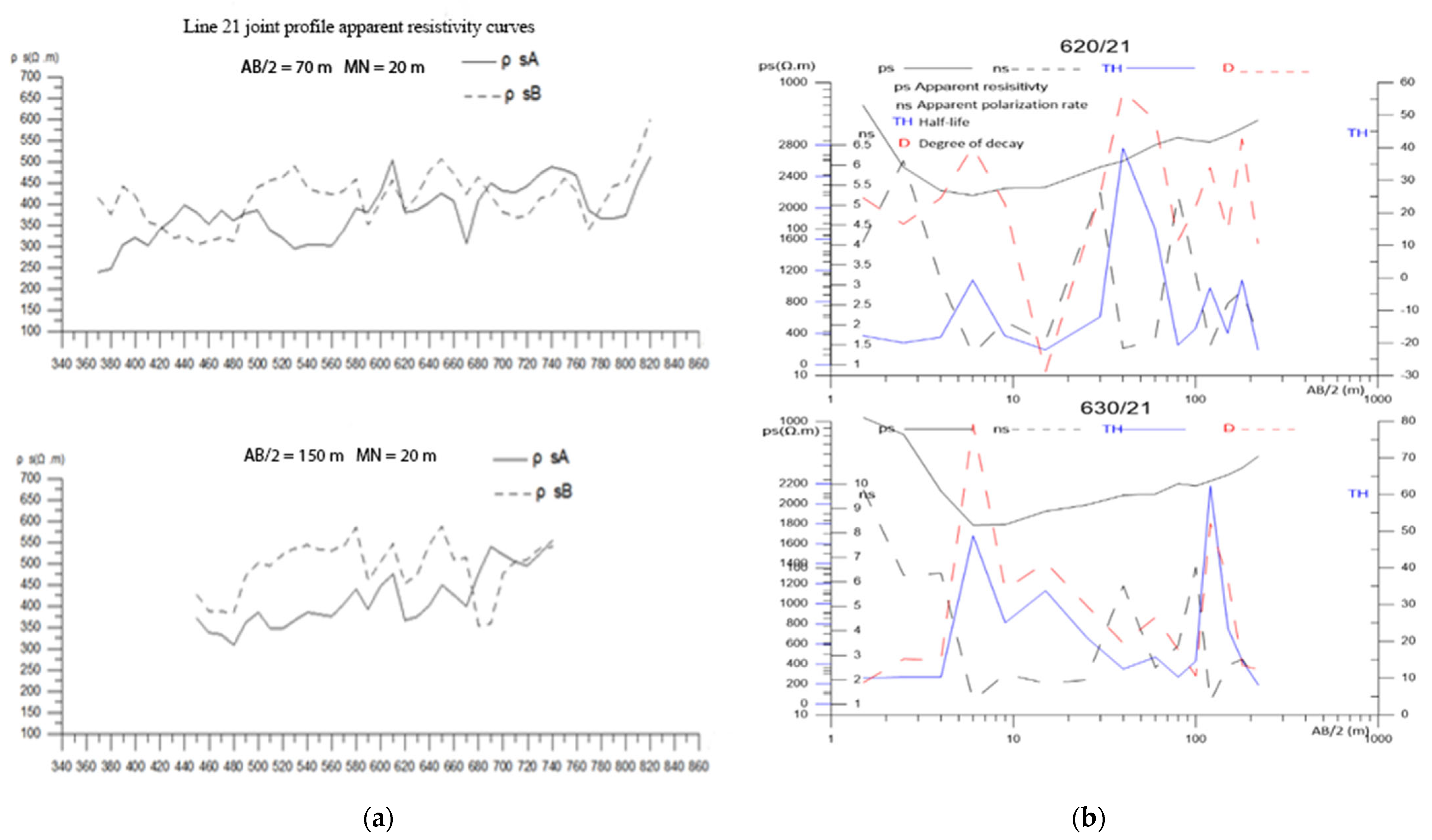
| Xiaoyuan Village, Dongshanba Town, Ningdu County | 20 | Joint profile method | 38 | The measurement line parallel to the inferred fault can increase the interpretation accuracy of the joint profile method; taking the bottom of the gully as the midpoint can make full use of the effective detection depth of electrical resistivity tomography method | |
| Electrical resistivity method | 60 | ||||
| 21 | Joint profile method | 38 | |||
| Electrical resistivity tomography method | 60 | ||||
| IP sounding | 2 |
| Serial No. | Survey Area | Description of Borehole Lithology and Water Content | Pumping Test and Drawing Volume Recommendations |
|---|---|---|---|
| 1 | Qingtang Middle School, Ningdu County | The depth of the hole is 80.1 m, of which 0–25.44 m is the pore water of the Quaternary loose rock formation, and the thickness is 25.44 m. The seamless steel pipe separates the water in this layer and is not taken. 25.44–80.1 m is Carboniferous Huanglong Formation carbonate karst water, with a thickness of 54.66 m, which is the main aquifer of this hole, with good water-richness, and is the main water intake layer of this “exploration–production combined well”. | From 05:54 on 12 October 2019 to 06:55 on 13 October 2019. The dynamic water level was 12.2 m, the triangular weir was 12.3 cm high, and the steady flow rate was 641.81 m3/d. The water volume is 188.77 m3/d.m., which fully meets the needs of the existing 1300 students and teachers. |
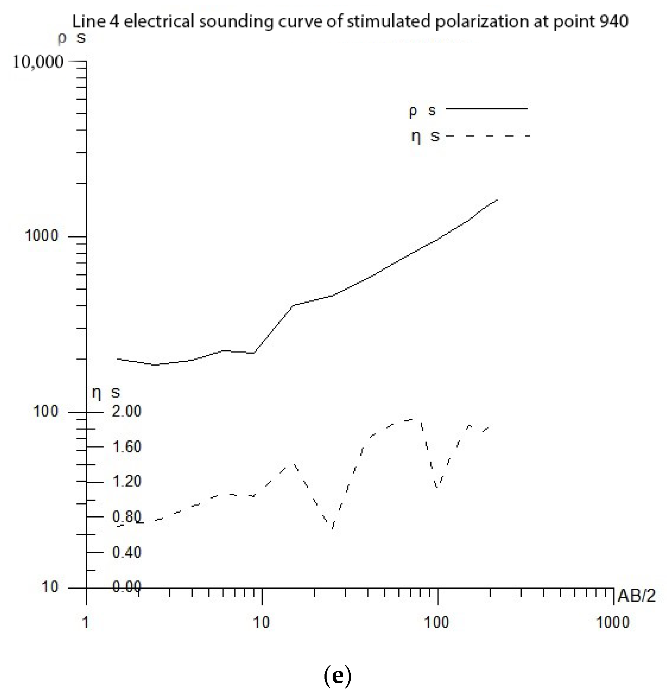
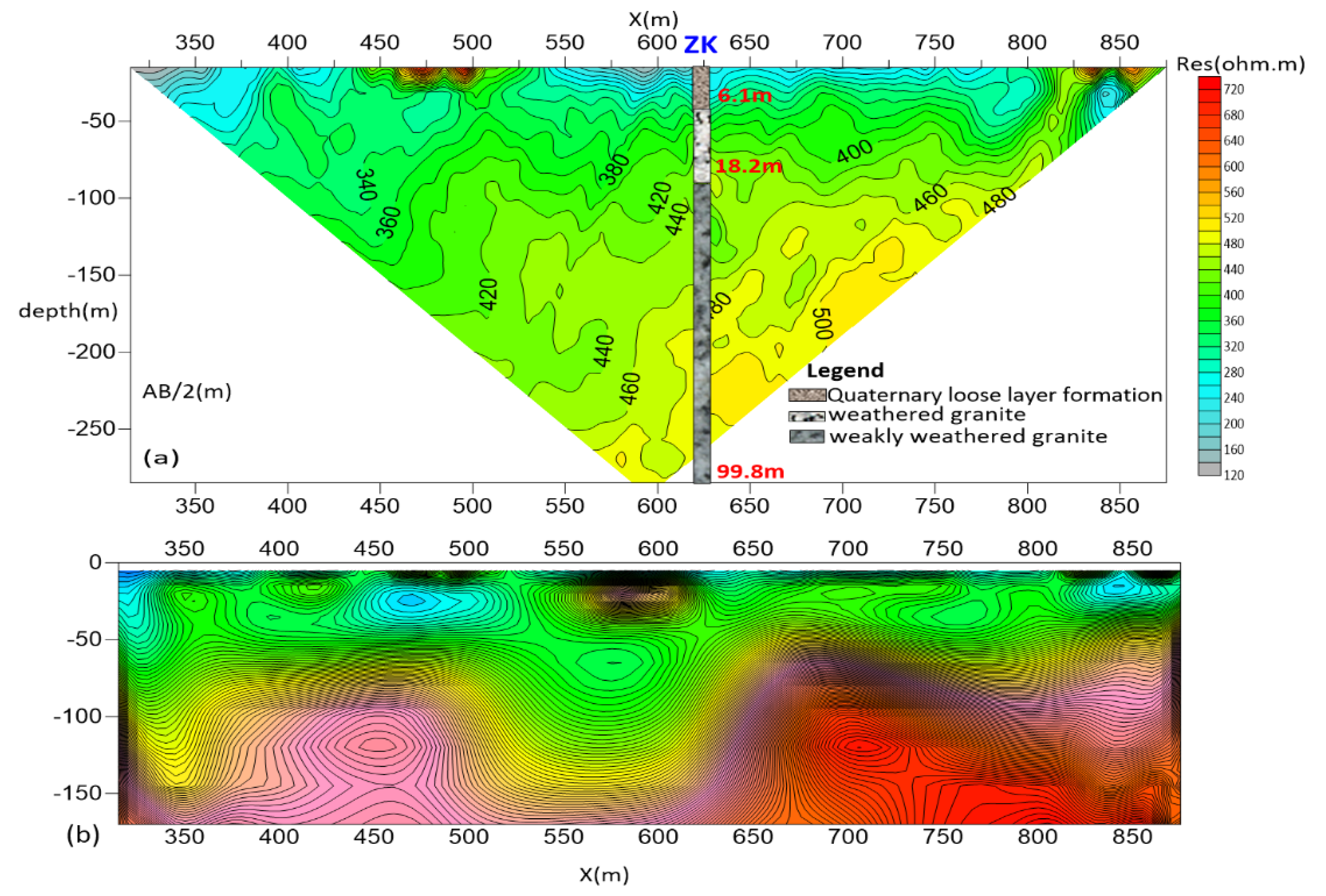
| 2 | Xiaoyuan Village, Dongshanba Town, Ningdu County | The drilled depth is 99.8 m. 0–6.1 m Quaternary loose layer formation, and the thickness is 0.5 m. The lithology of the aquifer is cultivated soil, etc., and the water-rich property is weak. Containing pore water-richness is water medium in nature; 6.1–18.2 m weathered granite, containing reticulated fissure water, strong water-richness with a thickness of 22.5 m; 18.2–99.8 m weakly weathered granite with joints and fissures with a thickness of 58.22 m, and the water-rich property is weak. The reticular fissure water in the granite weathering zone and the fissure water in the granite bedrock are the main aquifers in this hole and are the main water intake layers of this exploration–production combined well. | From 2–6 October 2019, the well was drawn down to a depth of 10.5 m and a steady flow rate of 968.4 t/d. A drinking water volume of 40–60 L/person per day is basically up to the standard, 60 L/person day or more is fully up to the standard, and the mining volume of 180 tons/day can meet the acceptance requirements for safe drinking water. Calculating with reference to the long-term water quota of 100 L per person per day for rural residents, 300 tons per day of water can fully meet the drinking water needs of Xiaoyuan Village. To sum up, the current number of people in Xiaoyuan Village who are short of water is 3500 people; it is recommended that the mining volume should not exceed 300 tons per day. |
| Drawdown Sw (m) | Water Inflow Q (m3/d) | Test Section Thickness H (m) | Pumping Well Radius r(m) | Radius of Influence R (m) | Permeability Coefficient K (m/d) |
|---|---|---|---|---|---|
| S1 = 10.2 | 737.09 | 54.66 | 0.074 | 199.41 | 3.822 |
| S2 = 6.8 | 709.03 | 54.66 | 0.074 | 157.27 | 5.349 |
| S3 = 3.4 | 641.81 | 54.66 | 0.074 | 102.83 | 9.147 |
| Average value | 153.17 | 6.106 | |||
| Drawdown Sw (m) | Water Inflow Q (m3/d) | Test Section Thickness H (m) | Pumping Well Radius r (m) | Radius of Influence R (m) | Permeability Coefficient K (m/d) |
|---|---|---|---|---|---|
| S1 = 10.5 | 968.40 | 97.80 | 0.074 | 365.80 | 3.102 |
| S2 = 7.0 | 810.00 | 97.80 | 0.074 | 265.45 | 3.676 |
| S3 = 3.5 | 668.22 | 97.80 | 0.074 | 163.87 | 5.604 |
| Average value | 265.04 | 4.127 | |||
Disclaimer/Publisher’s Note: The statements, opinions and data contained in all publications are solely those of the individual author(s) and contributor(s) and not of MDPI and/or the editor(s). MDPI and/or the editor(s) disclaim responsibility for any injury to people or property resulting from any ideas, methods, instructions or products referred to in the content. |
© 2023 by the authors. Licensee MDPI, Basel, Switzerland. This article is an open access article distributed under the terms and conditions of the Creative Commons Attribution (CC BY) license (https://creativecommons.org/licenses/by/4.0/).
Share and Cite
Lubang, J.; Liu, H.; Chen, R. Combined Application of Hydrogeological and Geoelectrical Study in Groundwater Exploration in Karst-Granite Areas, Jiangxi Province. Water 2023, 15, 865. https://doi.org/10.3390/w15050865
Lubang J, Liu H, Chen R. Combined Application of Hydrogeological and Geoelectrical Study in Groundwater Exploration in Karst-Granite Areas, Jiangxi Province. Water. 2023; 15(5):865. https://doi.org/10.3390/w15050865
Chicago/Turabian StyleLubang, Jacob, Haifei Liu, and Rujun Chen. 2023. "Combined Application of Hydrogeological and Geoelectrical Study in Groundwater Exploration in Karst-Granite Areas, Jiangxi Province" Water 15, no. 5: 865. https://doi.org/10.3390/w15050865
APA StyleLubang, J., Liu, H., & Chen, R. (2023). Combined Application of Hydrogeological and Geoelectrical Study in Groundwater Exploration in Karst-Granite Areas, Jiangxi Province. Water, 15(5), 865. https://doi.org/10.3390/w15050865