Different Paths for Developing Terrestrial LiDAR Data for Comparative Analyses of Topographic Surface Changes


Abstract
:1. Introduction
2. Materials and Methods
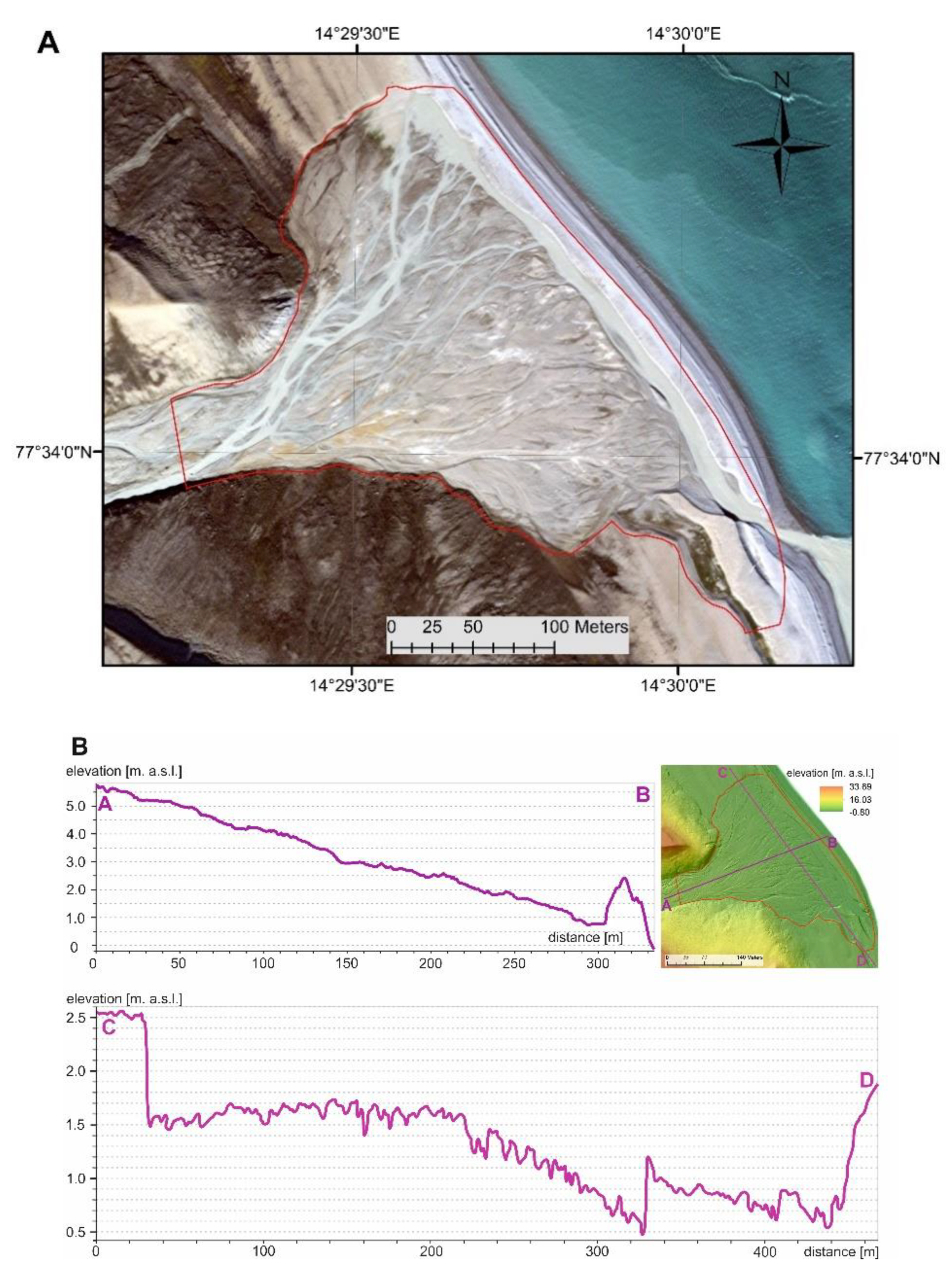
2.1. Study Area
2.2. Methods
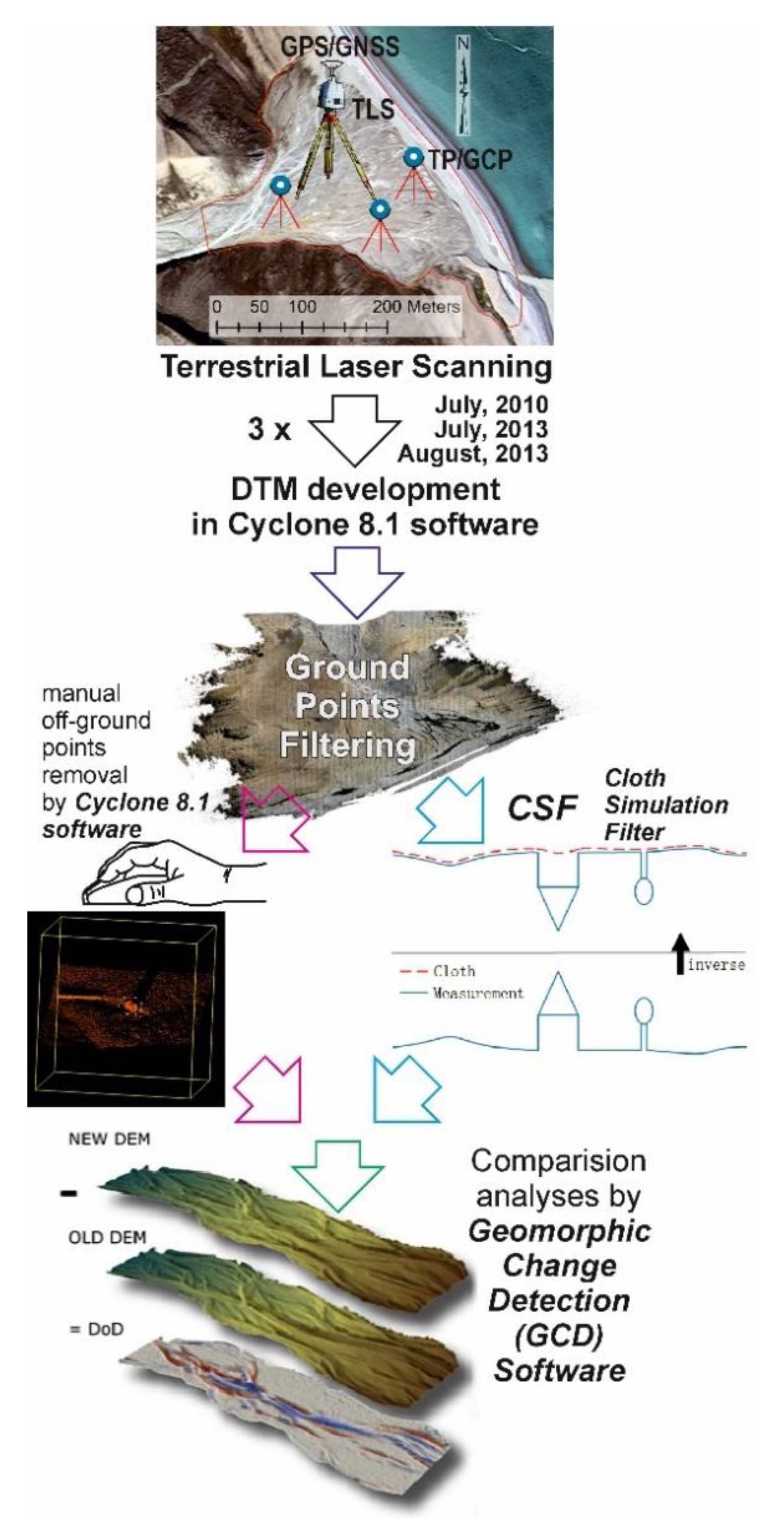
2.2.1. High Resolution Surveying: LiDAR-Derived Digital Terrain Model (DTM)
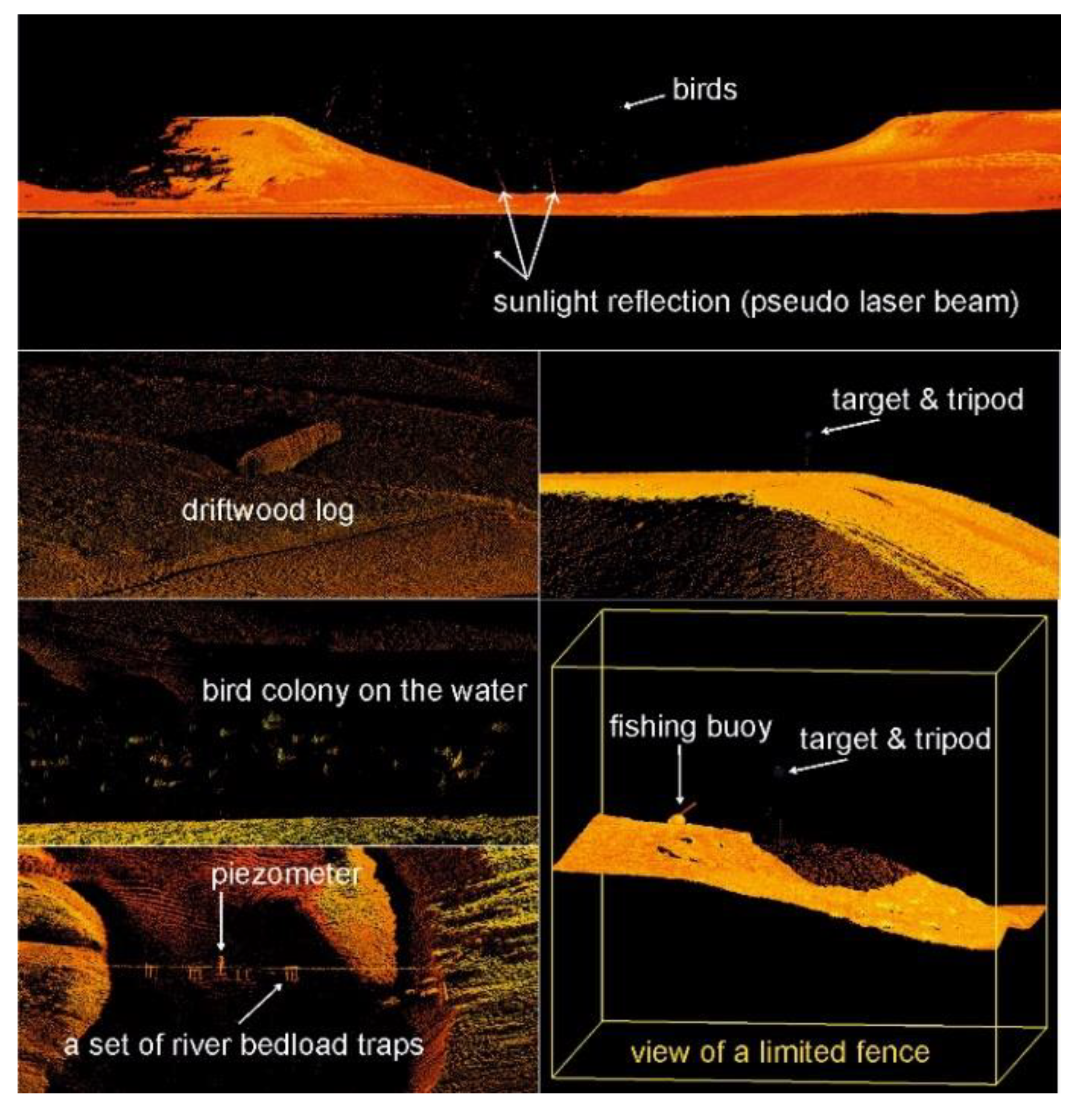
2.2.2. Classification of Ground Points and DEM Development
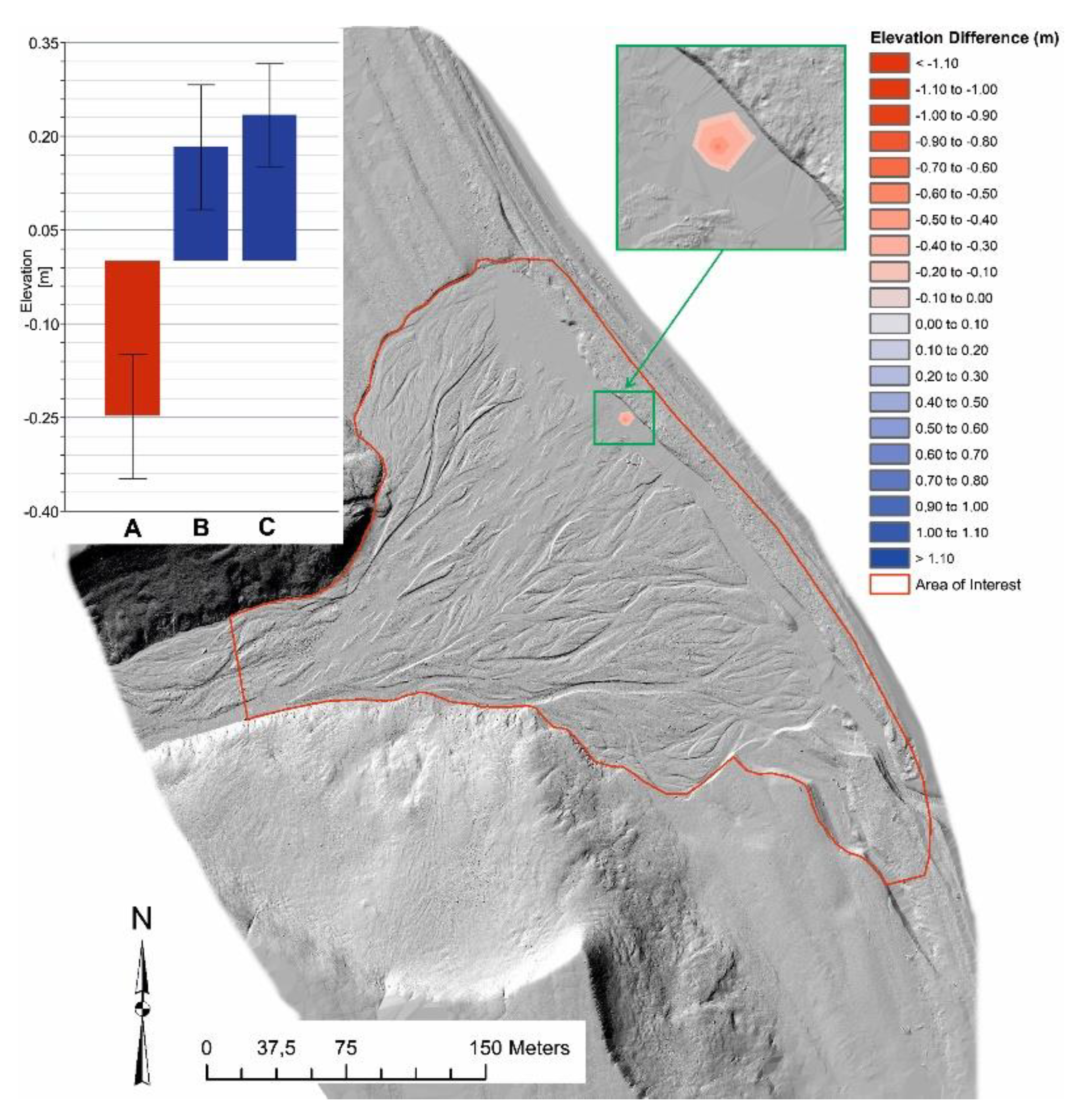
2.2.3. Surface Change Detection by DEM of Difference (DoD)
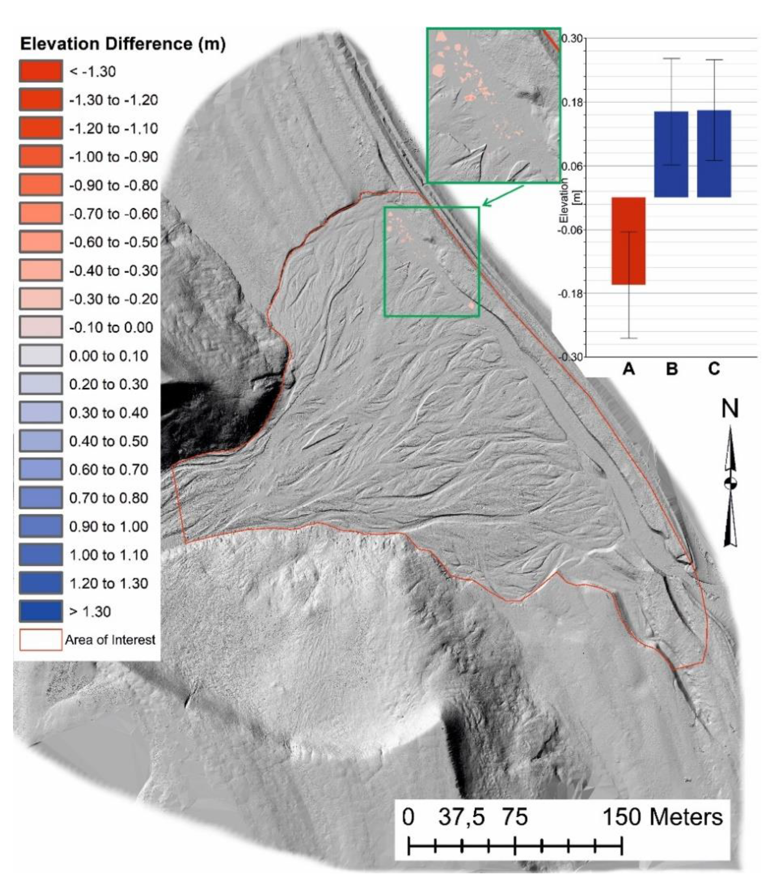
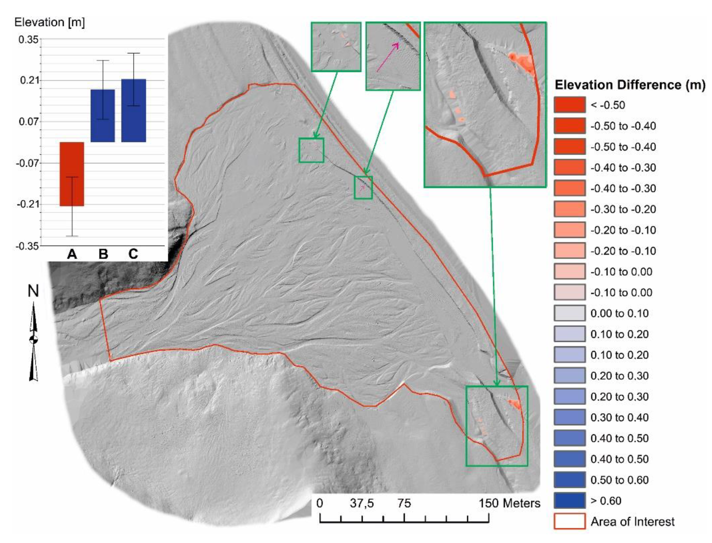
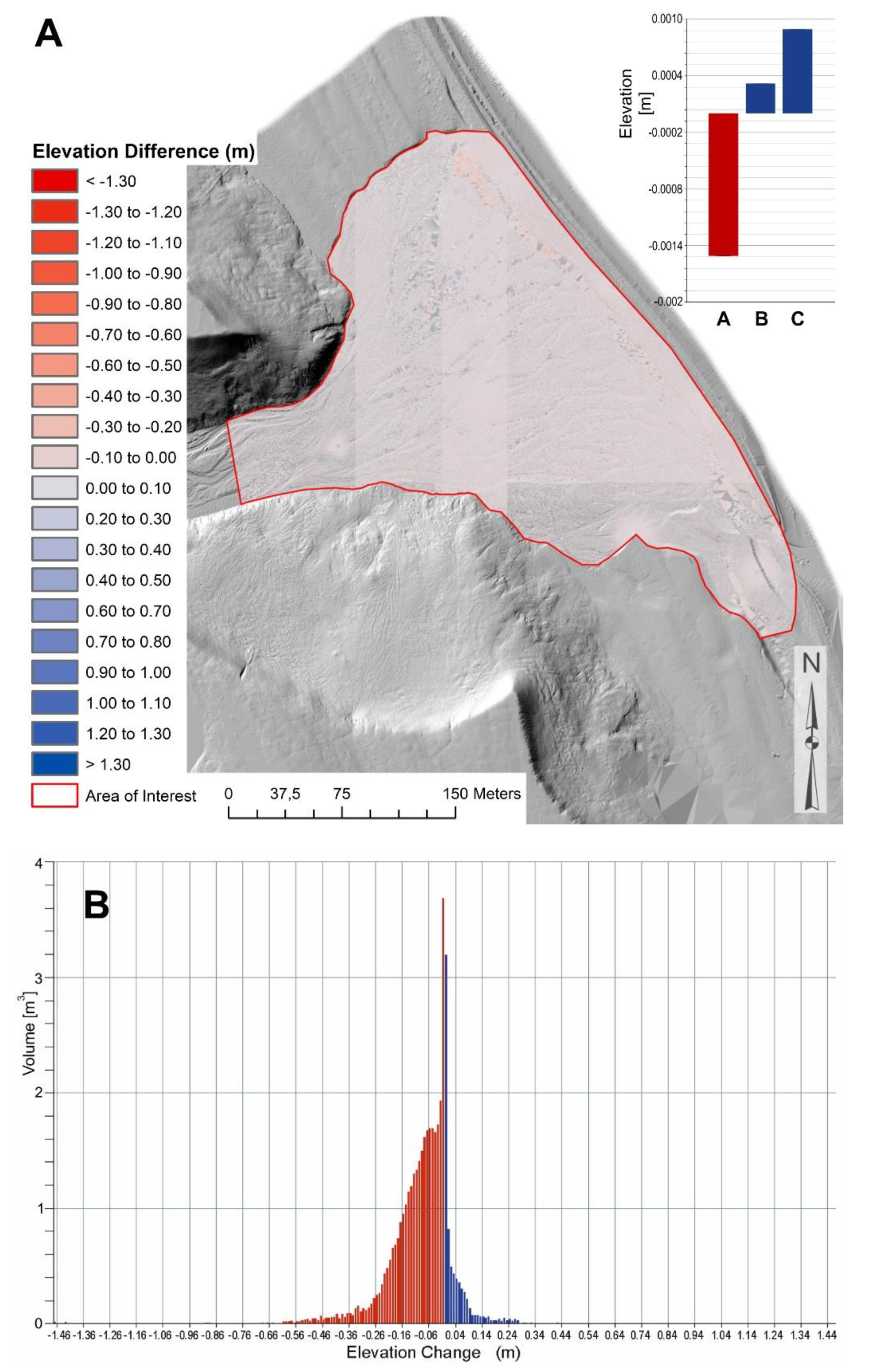
3. Results
4. Discussion
5. Conclusions
Funding
Acknowledgments
Conflicts of Interest
References
- Yan, W.Y.; Shaker, A.; El-Ashmawy, N. Urban land cover classification using airborne LiDAR data: A review. Remote Sens. Environ. 2015, 158, 295–310. [Google Scholar] [CrossRef]
- Kociuba, W. Analysis of geomorphic changes and quantification of sediment budgets of a small Arctic valley with the application of repeat TLS surveys. Z. Geomorphol. 2017, 61, 105–120. [Google Scholar] [CrossRef]
- Milan, D.J.; Heritage, G.L.; Hetherington, D. Application of a 3D laser scanner in the assessment of erosion and deposition volumes and channel change in a proglacial river. Earth Surf. Process. Landf. 2007, 32, 1657–1674. [Google Scholar] [CrossRef]
- Bangen, S.G.; Wheaton, J.M.; Bouwes, N.; Bouwes, B.; Jordan, C. A methodological intercomparison of topographic survey techniques for characterizing wadeable streams and rivers. Geomorphology 2014, 206, 343–361. [Google Scholar] [CrossRef]
- Wack, R.; Wimmer, A. Digital Terrain Models from Airborne Laser Scanner Data—A Grid Based Approach; International Archives of Photogrammetry and Remote Sensing: Graz, Austria, 2002; Volume 34. [Google Scholar]
- Wężyk, P.; Szostak, M.; Krzaklewski, W.; Pająk, M.; Pierzchalski, M.; Szwed, P.; Hawryło, P.P.; Ratajczak, M. Landscape monitoring of post-industrial areas using LiDAR and GIS technology. Geod. Cartogr. 2015, 64, 125–137. [Google Scholar] [CrossRef] [Green Version]
- Boyko, A.; Funkhouser, T. Extracting roads from dense point clouds in large scale urban environment. ISPRS J. Photogramm. Remote Sens. 2011, 66, S2–S12. [Google Scholar] [CrossRef] [Green Version]
- Wang, J.; González-Jorge, H.; Lindenbergh, R.; Arias-Sánchez, P.; Menenti, M. Automatic estimation of excavation volume from laser mobile mapping data for mountain road widening. Remote Sens. 2013, 5, 4629–4651. [Google Scholar] [CrossRef] [Green Version]
- Quackenbush, L.J.; Im, I.; Zuo, Y. Road extraction: A review of LiDAR-focused studies. Remote Sens. Nat. Resour. 2013, 7, 155–169. [Google Scholar]
- Jaboyedoff, M.; Oppikofer, T.; Abellan, A.; Derron, M.H.; Alexandre, L.; Metzger, R.; Pedrazzini, A. Use of LIDAR in landslide investigations: A review. Nat. Hazards 2015, 61, 5–28. [Google Scholar] [CrossRef] [Green Version]
- Teo, T.-A.; Wu, H.-M. Analysis of land cover classification using multi-wavelength LiDAR system. Appl. Sci. 2017, 7, 663. [Google Scholar] [CrossRef] [Green Version]
- Blistan, P.; Jacko, S.; Kovanič, Ľ.; Kondela, J.; Pukanská, K.; Bartoš, K. TLS and SfM approach for bulk density determination of excavated heterogeneous raw materials. Minerals 2020, 10, 174. [Google Scholar] [CrossRef] [Green Version]
- Wheaton, J.M. Uncertainty in Morphological Sediment Budgeting of Rivers. Ph.D. Thesis, University of Southampton, Southampton, UK, 2008. [Google Scholar]
- Heritage, G.L.; Milan, D.J.; Large, A.R.G.; Fuller, I.C. Influence of survey strategy and interpolation model on DEM quality. Geomorphology 2009, 112, 334–344. [Google Scholar] [CrossRef]
- Wheaton, J.M.; Brasington, J.; Darby, S.E.; Sear, D.A. Accounting for uncertainty in DEMs from repeat topographic surveys: Improved sediment budgets. Earth Surf. Process. Landf. 2010, 35, 136–156. [Google Scholar] [CrossRef]
- Wheaton, J.M.; Brasington, J.; Darby, S.E.; Sear, D.A.; Kasprak, A. Morphodynamic signatures of braiding mechanisms as expressed through change in sediment storage in a gravel-bed river. J. Geophys. Res. Earth Surf. 2013, 118, 759–779. [Google Scholar] [CrossRef] [Green Version]
- Milan, D.J.; Heritage, G.L.; Large, A.R.G.; Fuller, I.C. Filtering spatial error from DEMs: Implications for morphological change estimation. Geomorphology 2011, 125, 160–171. [Google Scholar] [CrossRef]
- Schwendel, A.C.; Fuller, I.C.; Death, R.G. Assessing DEM interpolation methods for effective representation of upland stream morphology for rapid appraisal of bed stability. River Res. Appl. 2012, 28, 567–584. [Google Scholar] [CrossRef] [Green Version]
- Axelsson, P. DEM generation from laser scanner data using adaptive TIN models. Int. Arch. Photogramm. Remote Sens. 2000, 33, 203–210. [Google Scholar]
- ASPRS Standard LIDAR Point Classes 2008. Available online: https://www.asprs.org/a/society/committees/standards/asprs_las_format_v12.pdf (accessed on 15 May 2020).
- Chen, Z.; Gao, B.; Devereux, B. State-of-the-art: DTM generation using airborne LIDAR data. Sensors 2017, 17, 150. [Google Scholar] [CrossRef] [Green Version]
- Chen, C.; Yue, T. A method of DEM construction and related error analysis. Comput. Geosci. 2010, 36, 717–725. [Google Scholar] [CrossRef]
- Sithole, G.; Vosselman, G. Report: ISPRS Comparison of Filters; Department of Geodesy, Faculty of Civil Engineering and Geosciences, Delft University of Technology: Delft, The Netherlands, 2003. [Google Scholar]
- Montealegre, A.L.; Lamelas, M.T.; de la Riva, J. A comparison of open-source LiDAR filtering algorithms in a Mediterranean forest environment. IEEE J. Sel. Top. Appl. Earth Obs. Remote Sens. 2015, 8, 4072–4085. [Google Scholar] [CrossRef] [Green Version]
- Kraus, K.; Pfeifer, N. Determination of terrain models in wooded areas with airborne laser scanner data. ISPRS J. Photogramm. Remote Sens. 1998, 53, 193–203. [Google Scholar] [CrossRef]
- Pingel, T.J.; Clarke, K.C.; McBride, W.A. An improved simple morphological filter for the terrain classification of airborne LIDAR data. ISPRS J. Photogramm. Remote Sens. 2013, 77, 21–30. [Google Scholar] [CrossRef]
- Meng, X.; Currit, N.; Zhao, K. Ground filtering algorithms for airborne LiDAR data: A review of critical issues. Remote Sens. 2010, 2, 833–860. [Google Scholar] [CrossRef] [Green Version]
- Zhang, W.; Qi, J.; Wan, P.; Wang, H.; Xie, D.; Wang, X.; Yan, G. An easy-to-use airborne LiDAR data filtering method based on cloth simulation. Remote Sens. 2016, 8, 501. [Google Scholar] [CrossRef]
- Cereda, S. A comparison of Different Neural Networks for Agricultural Image Segmentation. Master’s Thesis, Politecnico di Milano, Milano, Italy, 2017. [Google Scholar]
- Dyson, J.; Mancini, A.; Frontoni, E.; Zingaretti, P. Deep learning for soil and crop segmentation from remotely sensed data. Remote Sens. 2019, 11, 1859. [Google Scholar] [CrossRef] [Green Version]
- Kociuba, W.; Krząstek, P.; Superson, J. Combining GPS-RTK and rephotographic methodologies for the assessment of transformations of the ephemeral landforms of the near foreland of a valley glacier (Scottbreen, Svalbard). Z. Geomorphol. 2016, 60, 29–44. [Google Scholar] [CrossRef]
- Harasimiuk, M.; Gajek, G. Tectonic and lithology. In Geographical Environment of NW Part of Wedel Jarlsberg Land (Spitsbergen, Svalbard); Zagórski, P., Harasimiuk, M., Rodzik, J., Eds.; Wydawnictwo UMCS: Lublin, Poland, 2013; pp. 34–47. [Google Scholar]
- Leica-Geosystems. Leica ScanStation C10-Datasheet. 2012. Available online: http://www.leica-geosystems.co.uk/downloads123/hds/hds/ScanStation%20C10/brochures-datasheet/Leica_ScanStation_C10_DS_en.pdf (accessed on 15 May 2020).
- Kociuba, W. Assessment of sediment sources throughout the proglacial area of a small Arctic catchment based on high-resolution digital elevation models. Geomorphology 2017, 287, 73–89. [Google Scholar] [CrossRef]
- Bremer, M.; Sass, O. Combining airborne and terrestrial laser scanning for quantifying erosion and deposition by a debris flow event. Geomorphology 2012, 138, 49–60. [Google Scholar] [CrossRef]
- Kociuba, W.; Kubisz, W.; Zagórski, P. Use of terrestrial laser scanning (TLS) for monitoring and modelling of geomorphic processes and phenomena at a small and medium spatial scale in Polar environment (Scott River—Spitsbergen). Geomorphology 2014, 212, 84–96. [Google Scholar] [CrossRef]
- Žalik, B.; Mongus, D.; Lukač, N. Ground and building extraction from LiDAR data based on differential morphological profiles and locally fitted surfaces. ISPRS J. Photogramm. Remote Sens. 2014, 93, 145–156. [Google Scholar]
- Evans, J.S.; Hudak, A.T. A multiscale curvature algorithm for classifying discrete return lidar in forested environments. IEEE Trans. Geosci. Remote Sens. 2007, 45, 1029–1038. [Google Scholar] [CrossRef]
- Streutker, D.; Glenn, N. LiDAR measurement of sagebrush steppe vegetation heights. Remote Sens. Environ. 2006, 102, 135–145. [Google Scholar] [CrossRef]
- Tinkham, W.T.; Hongyu, H.; Smith, A.M.S.; Shrestha, R.; Falkowski, M.J.; Hudak, A.T.; Link, T.E.; Glenn, N.F.; Marks, D.G. A comparison of two open source LiDAR surface classification algorithms. Remote Sens. 2011, 3, 638–649. [Google Scholar] [CrossRef] [Green Version]
- Mongus, D.; Zalik, B. Parameter-free ground filtering of LiDAR data for automatic DTM generation. ISPRS J. Photogramm. Remote Sens. 2012, 67, 1–12. [Google Scholar] [CrossRef]
- Kociuba, W.; Janicki, G.; Rodzik, J.; Stępniewski, K. Comparison of volumetric and remote sensing methods (TLS) for assessing the development of a permanent forested loess gully. Nat. Hazards 2015, 79, 139–158. [Google Scholar] [CrossRef]


| Parameter | Unit | July 2010 | July 2013 | August 2013 |
|---|---|---|---|---|
| Total number of points (raw DTM) | pt | 52,358,443 | 70,071,395 | 45,207,502 |
| Point density at Area of Interest (AoI) | pt/m2 | 345 | 437 | 309 |
| Total number of ground points (manually removed) | pt | 52,351,107 | 68,389,716 | 45,121,473 |
| Total number of ground points (CSF filtered) | pt | 52,121,610 | 68,187,224 | 45,046,205 |
| Percent of changes (manually removed DTM) | % | 0.01 | 2.40 | 0.19 |
| Percent of changes (CSF filtered DTM) | % | 0.45 | 2.69 | 0.36 |
| Attribute | Raw | Thresholded DoD Estimate: | ||
|---|---|---|---|---|
| Areal Metrics | % of AoI | |||
| Total Area of Surface Lowering (m²) | 724 | 48 | 1.6% | |
| Total Area of Surface Raising (m²) | 716 | 13 | 1.6% | |
| Total Area of Detectable Change (m²) | 1440 | 61 | 4.0% | |
| Total Area of Interest (m²) | 45,444 | NA | NA | |
| Total Volumetric Metrics | ±Error Volume | % Error | ||
| Total Volume of Surface Lowering (m³) | 21 | 12 | ±5 | 40% |
| Total Volume of Surface Raising (m³) | 9 | 2 | ±1 | 55% |
| Total Volume of Difference (m³) | 30 | 14 | ±6 | 43% |
| Total Net Volume Difference (m³) | −12 | −10 | ±5 | −52% |
| Vertical Averages: | ||||
| Average Depth of Surface Lowering (m) | 0.03 | 0.25 | ±0.100 | 40% |
| Average Depth of Surface Raising (m) | 0.01 | 0.18 | ±0.100 | 55% |
| Average Total Thickness of Difference (m) for Area of Interest | 0.02 | 0.01 | ±0.004 | 43% |
| Average Net Thickness Difference (m) for Area of Interest | −0.01 | −0.01 | ±0.003 | −52% |
| Percentages (by volume) | ||||
| Percent Elevation Lowering | 69% | 84% | ||
| Percent Surface Raising | 31% | 16% | ||
| Percent Imbalance (departure from equilibrium) | −19% | −34% | ||
| Net to Total Volume Ratio | −38% | −67% | ||
| Attribute | Raw | Thresholded DoD Estimate: | ||
|---|---|---|---|---|
| Areal Metrics | % of AoI | |||
| Total Area of Surface Lowering (m²) | 21,977 | 89 | 0.40% | |
| Total Area of Surface Raising (m²) | 23,467 | 5 | 0.02% | |
| Total Area of Detectable Change (m²) | 45,444 | 94 | 0.21% | |
| Total Area of Interest (m²) | 45,444 | NA | NA | |
| Total Volumetric Metrics | ±Error Volume | % Error | ||
| Total Volume of Surface Lowering (m³) | 33 | 15 | ± 9 | 61% |
| Total Volume of Surface Raising (m³) | 7 | 1 | ± 1 | 62% |
| Total Volume of Difference (m³) | 41 | 15 | ± 9 | 61% |
| Total Net Volume Difference (m³) | −26 | −14 | ± 9 | −65% |
| Vertical Averages: | ||||
| Average Depth of Surface Lowering (m) | 0.0015 | 0.1645 | ± 0.1000 | 61% |
| Average Depth of Surface Raising (m) | 0.0003 | 0.1619 | ± 0.1000 | 62% |
| Average Total Thickness of Difference (m) for Area of Interest | 0.0009 | 0.0003 | ± 0.0002 | 61% |
| Average Net Thickness Difference (m) for Area of Interest | −0.0006 | −0.0003 | ± 0.0002 | −65% |
| Percentages (by volume) | ||||
| Percent Elevation Lowering | 82% | 95% | ||
| Percent Surface Raising | 18% | 5% | ||
| Percent Imbalance (departure from equilibrium) | −32% | −45% | ||
| Net to Total Volume Ratio | −63% | −89% | ||
| Attribute | Raw | Thresholded DoD Estimate: | ||
|---|---|---|---|---|
| Areal Metrics | % of AoI | |||
| Total Area of Surface Lowering (m²) | 13,595 | 91 | 0.67% | |
| Total Area of Surface Raising (m²) | 13,376 | 13 | 0.10% | |
| Total Area of Detectable Change (m²) | 26,971 | 104 | 0.39% | |
| Total Area of Interest (m²) | 45,444 | NA | NA | |
| Total Volumetric Metrics | ±Error Volume | % Error | ||
| Total Volume of Surface Lowering (m³) | 32 | 20 | ± 9 | 46% |
| Total Volume of Surface Raising (m³) | 11 | 2 | ± 1 | 56% |
| Total Volume of Difference (m³) | 43 | 22 | ± 10 | 47% |
| Total Net Volume Difference (m³) | −21 | −18 | ± 9 | −52% |
| Vertical Averages: | ||||
| Average Depth of Surface Lowering (m) | 0.002 | 0.217 | 0.1000 | 46% |
| Average Depth of Surface Raising (m) | 0.001 | 0.178 | 0.1000 | 56% |
| Average Total Thickness of Difference (m) for Area of Interest | 0.002 | 0.001 | 0.0004 | 47% |
| Average Net Thickness Difference (m) for Area of Interest | −0.001 | −0.001 | 0.0003 | −52% |
| Percentages (by volume) | ||||
| Percent Elevation Lowering | 75% | 90% | ||
| Percent Surface Raising | 25% | 10% | ||
| Percent Imbalance (departure from equilibrium) | −25% | −40% | ||
| Net to Total Volume Ratio | −49% | −80% | ||
Publisher’s Note: MDPI stays neutral with regard to jurisdictional claims in published maps and institutional affiliations. |
© 2020 by the author. Licensee MDPI, Basel, Switzerland. This article is an open access article distributed under the terms and conditions of the Creative Commons Attribution (CC BY) license (http://creativecommons.org/licenses/by/4.0/).
Share and Cite
Kociuba, W. Different Paths for Developing Terrestrial LiDAR Data for Comparative Analyses of Topographic Surface Changes. Appl. Sci. 2020, 10, 7409. https://doi.org/10.3390/app10217409
Kociuba W. Different Paths for Developing Terrestrial LiDAR Data for Comparative Analyses of Topographic Surface Changes. Applied Sciences. 2020; 10(21):7409. https://doi.org/10.3390/app10217409
Chicago/Turabian StyleKociuba, Waldemar. 2020. "Different Paths for Developing Terrestrial LiDAR Data for Comparative Analyses of Topographic Surface Changes" Applied Sciences 10, no. 21: 7409. https://doi.org/10.3390/app10217409
APA StyleKociuba, W. (2020). Different Paths for Developing Terrestrial LiDAR Data for Comparative Analyses of Topographic Surface Changes. Applied Sciences, 10(21), 7409. https://doi.org/10.3390/app10217409