
How to Quantify the Dynamics of Single (Straight or Sinuous) and Multiple (Anabranching) Channels from Imagery for River Restoration

 , and
, and
Abstract
:1. Introduction
- -
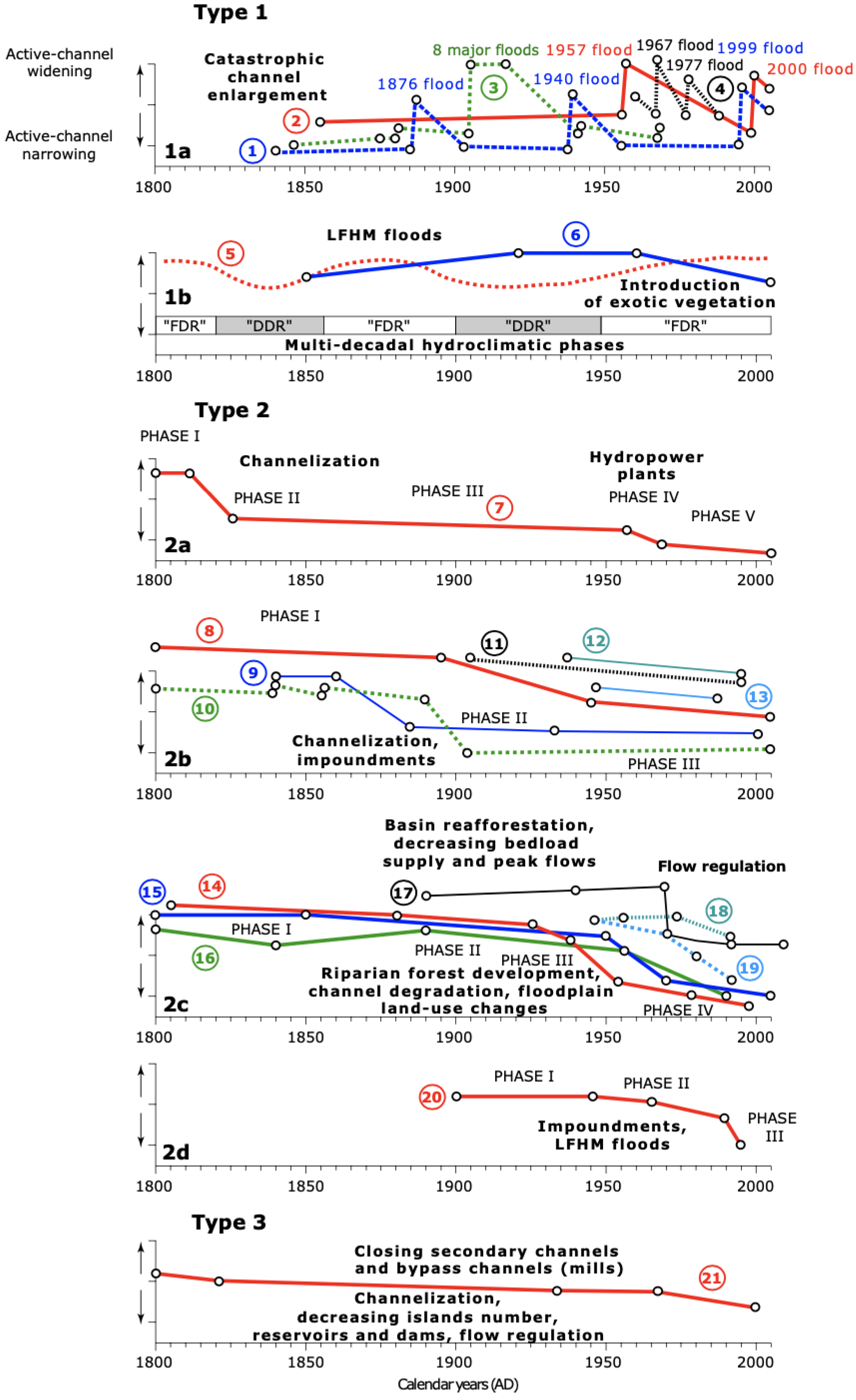
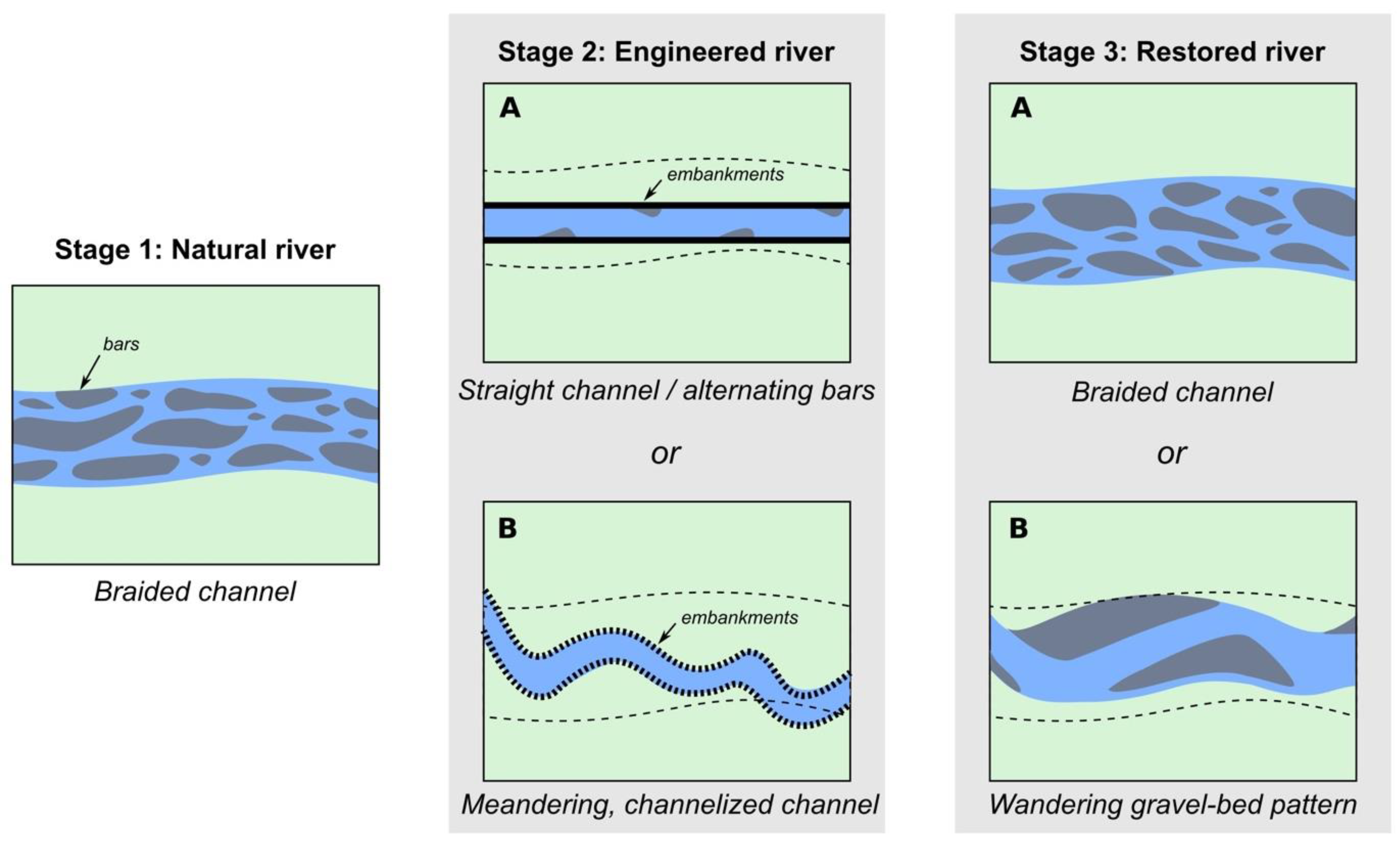
- Stage 1: before significant functionalization of rivers. This stage can be assimilated to the free-flowing state of rivers (generally, before the eighteenth–nineteenth century, but sometimes before the Modern Times or Middle Ages). Lengthening or shortening of active channels by variations of fluvial style due to allocyclic and/or autocyclic processes is (i) common in high-energy rivers, (ii) much less in low-energy rivers.
- -
- Stage 2: before embankment removal associated with river restoration. (i) In the natural context (not constricted), high-energy rivers show a good ability to lengthen/shorten their multiple or single channels. In low-energy rivers, channel lengthening/shortening is possible but limited. (ii) In the artificialized context (channelized), no significant channel lengthening/shortening is possible either in high-energy rivers or in low-energy rivers.
- -
- Stage 3 (since 2000 with the emergence of environmental policies such as WFD in Europe that encourages restoration works [27,33,34]: current embankment removal accompanying river restoration. (i) In a natural context (not constricted), high-energy rivers are able to lengthen/shorten their multiple or single channels. Low-energy rivers can also be characterized by small channel lengthening/shortening when this occurs. (ii) In an artificialized context (channelized), high-energy rivers are exposed to a possible lengthening/shortening of their multiple or single channels. Low-energy rivers encounter high difficulty in lengthening/shortening their channel, and morphological adjustments are only locally visible.
2. Proposed Methodology
2.1. The Purpose of New Indicators
2.1.1. Data Preparation
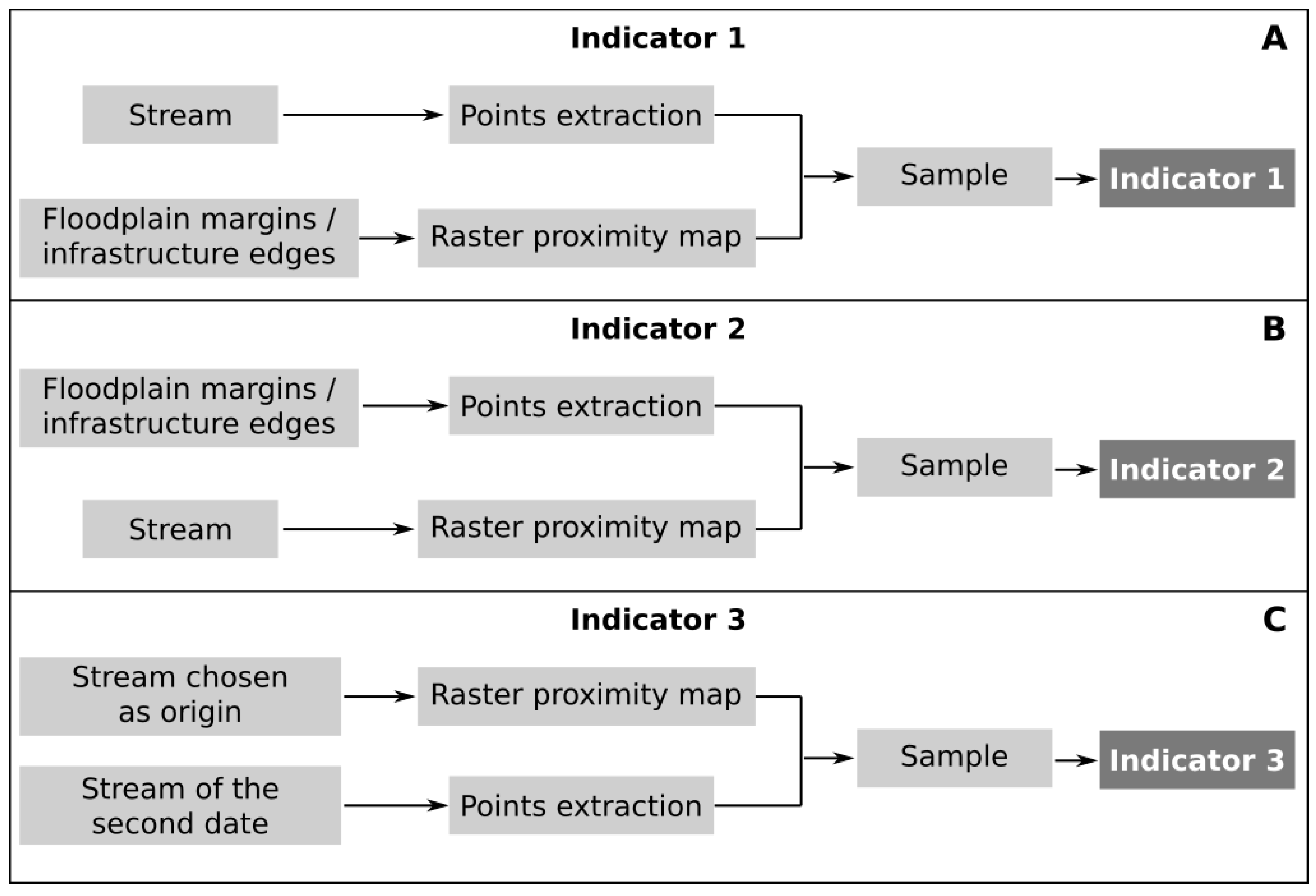
2.1.2. The Indicators
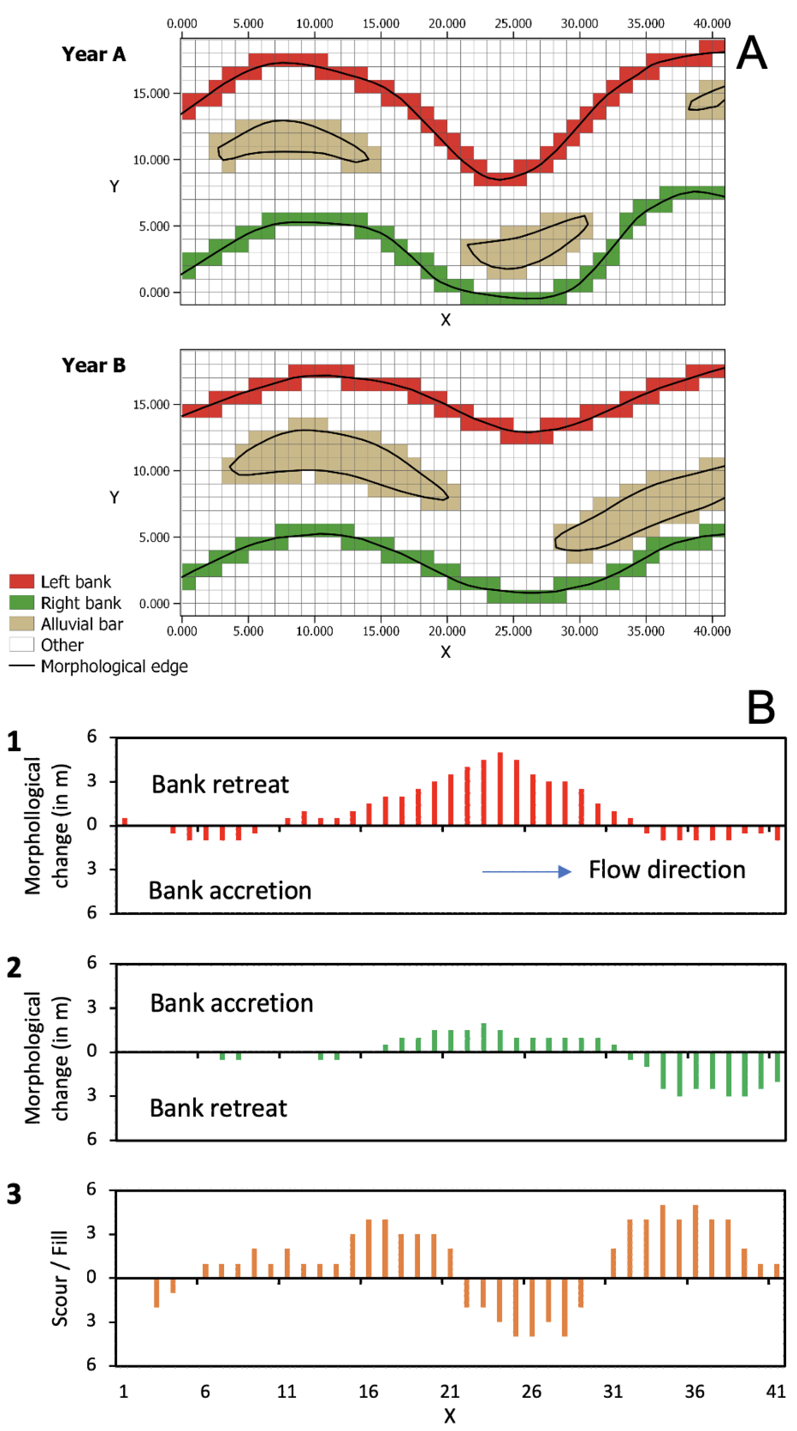
2.2. The Metric Analysis Grid Approach
3. Applied Methodology
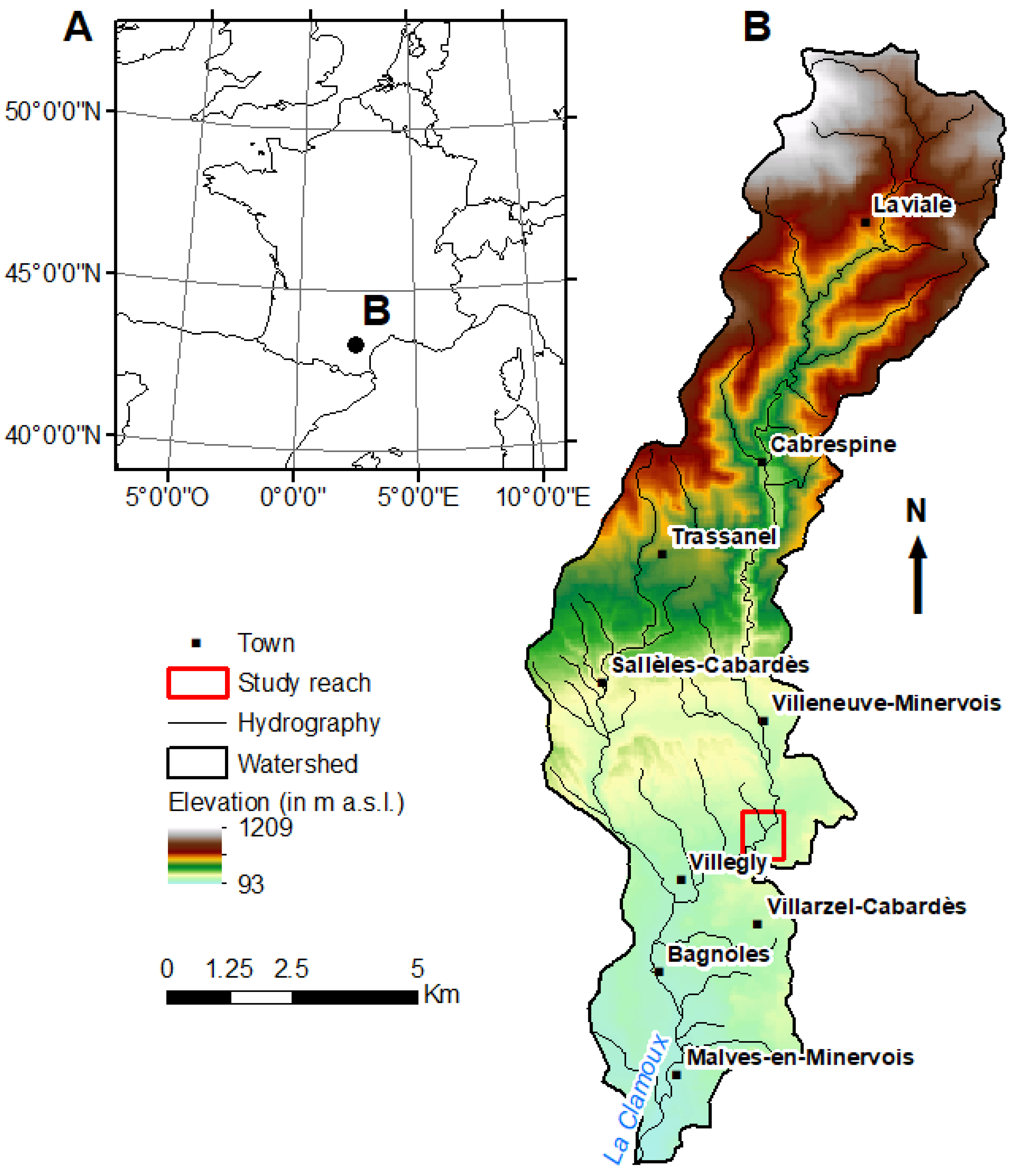
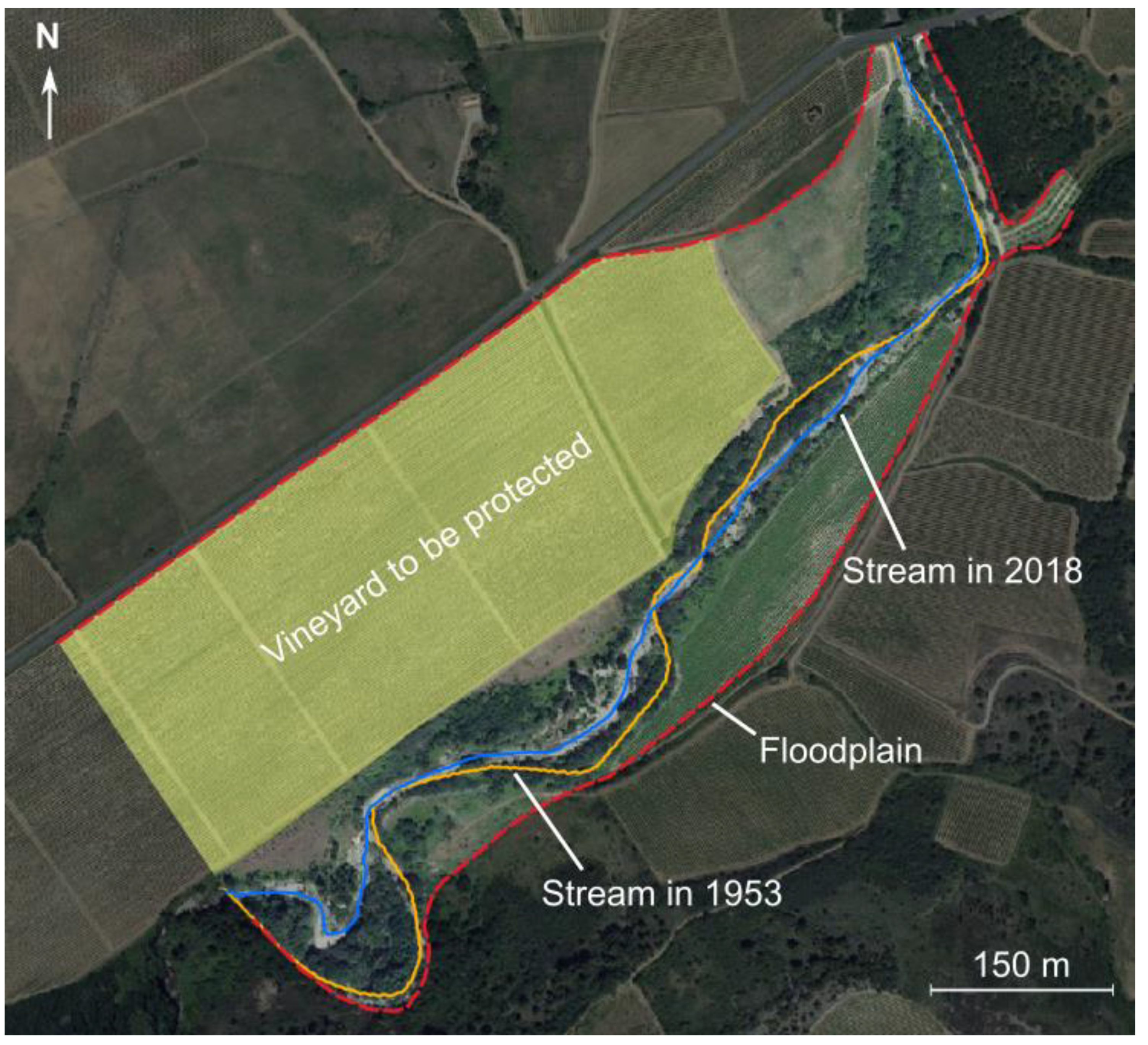
3.1. Study Area
3.2. Calculation of the Indicators
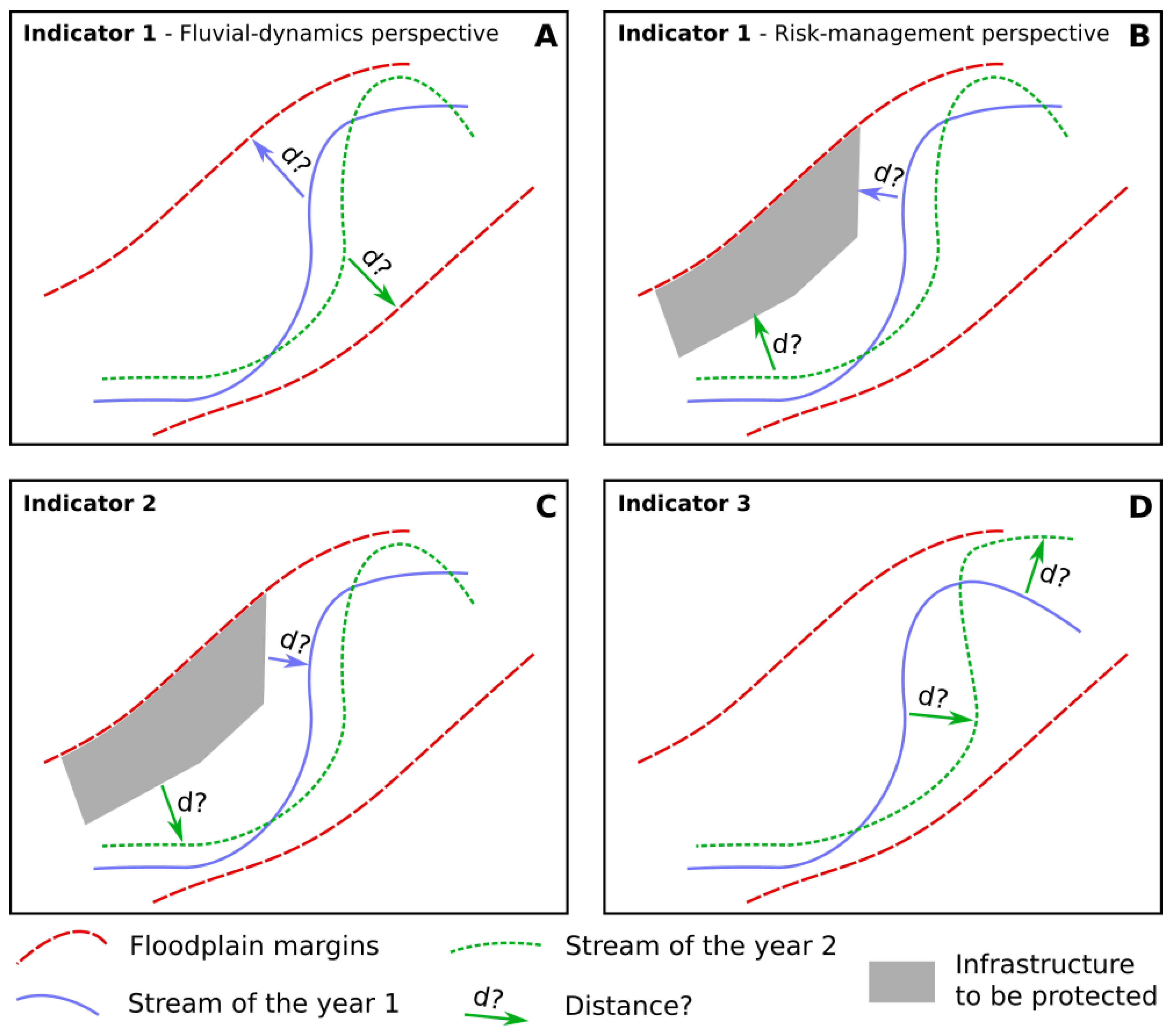
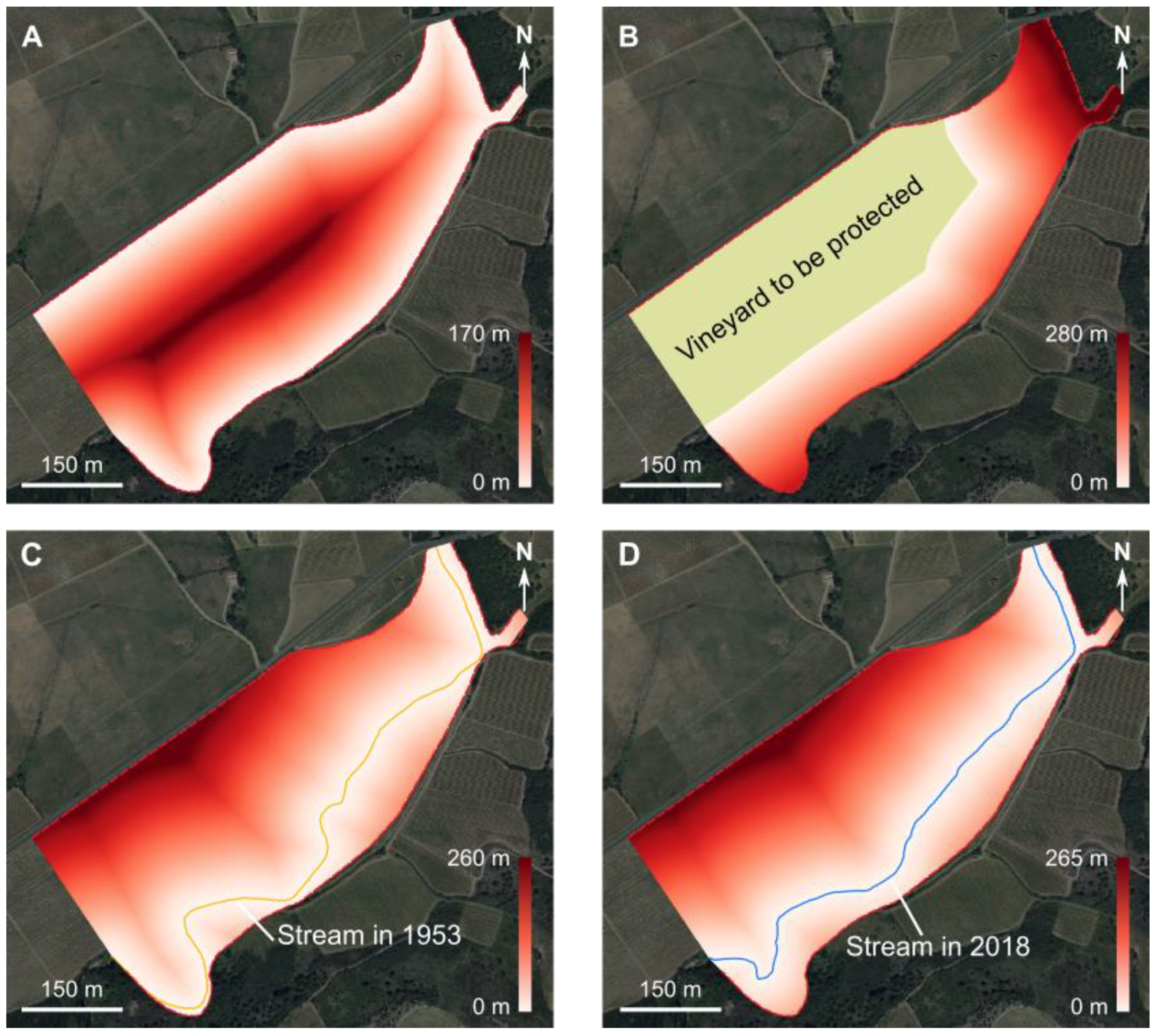
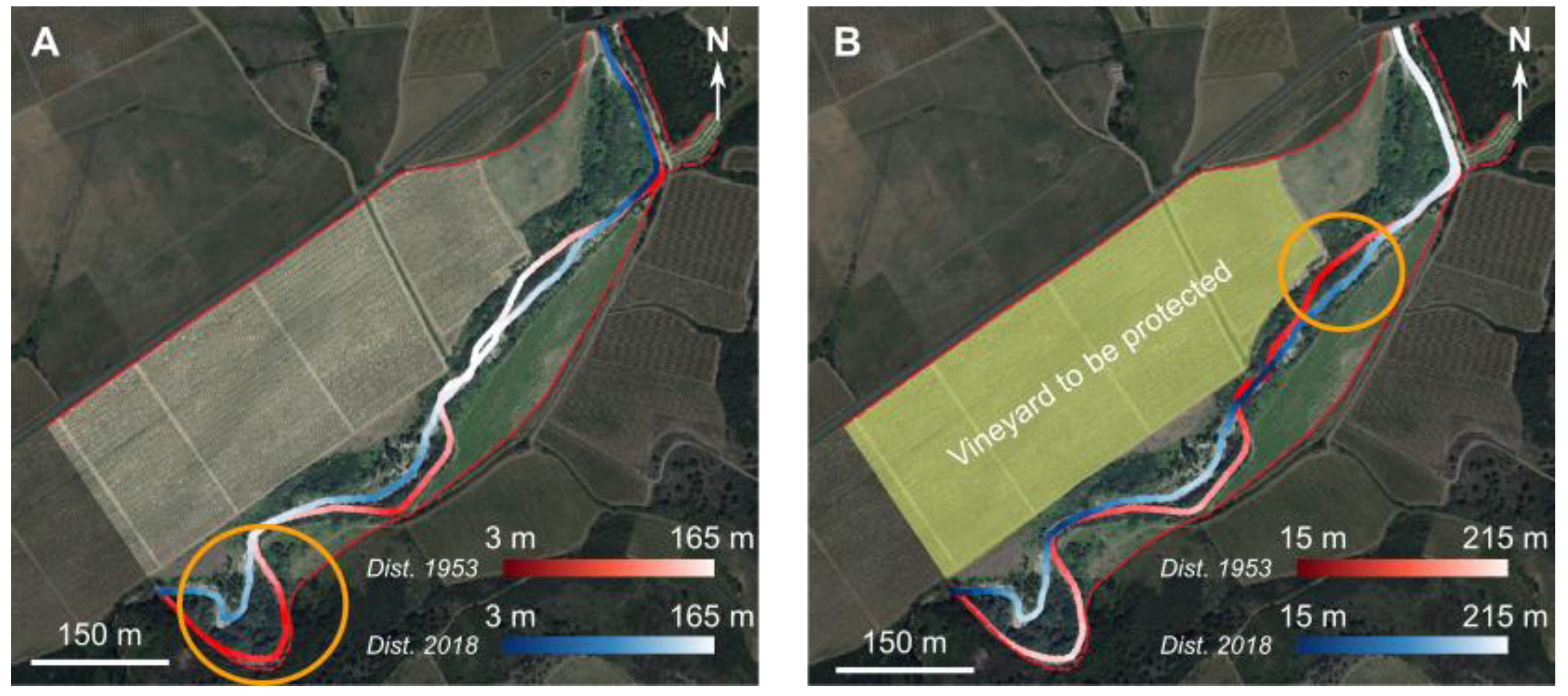
3.2.1. Indicator 1: Distance from Active Channel to Stakes or Floodplain Margins
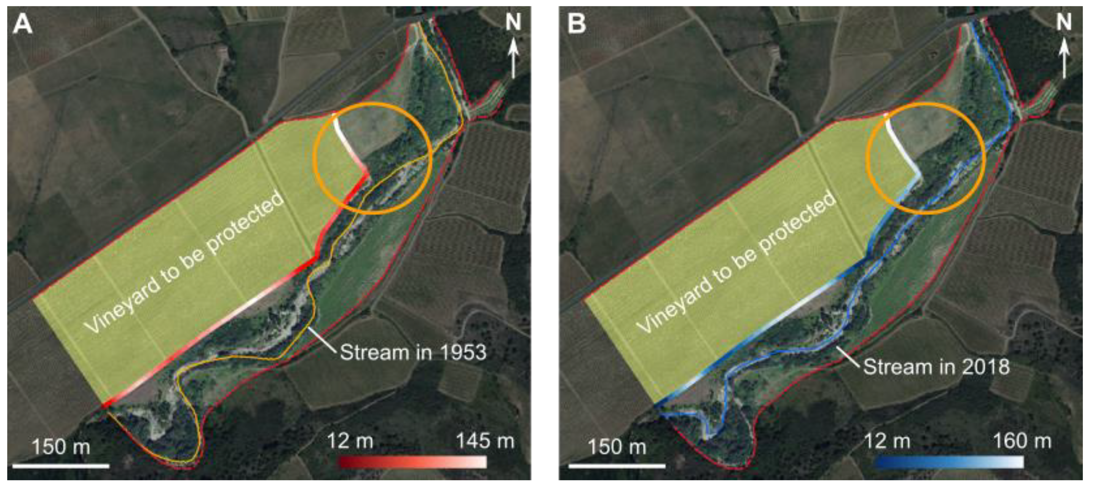
3.2.2. Indicator 2: Distance from Stakes to Active Channel
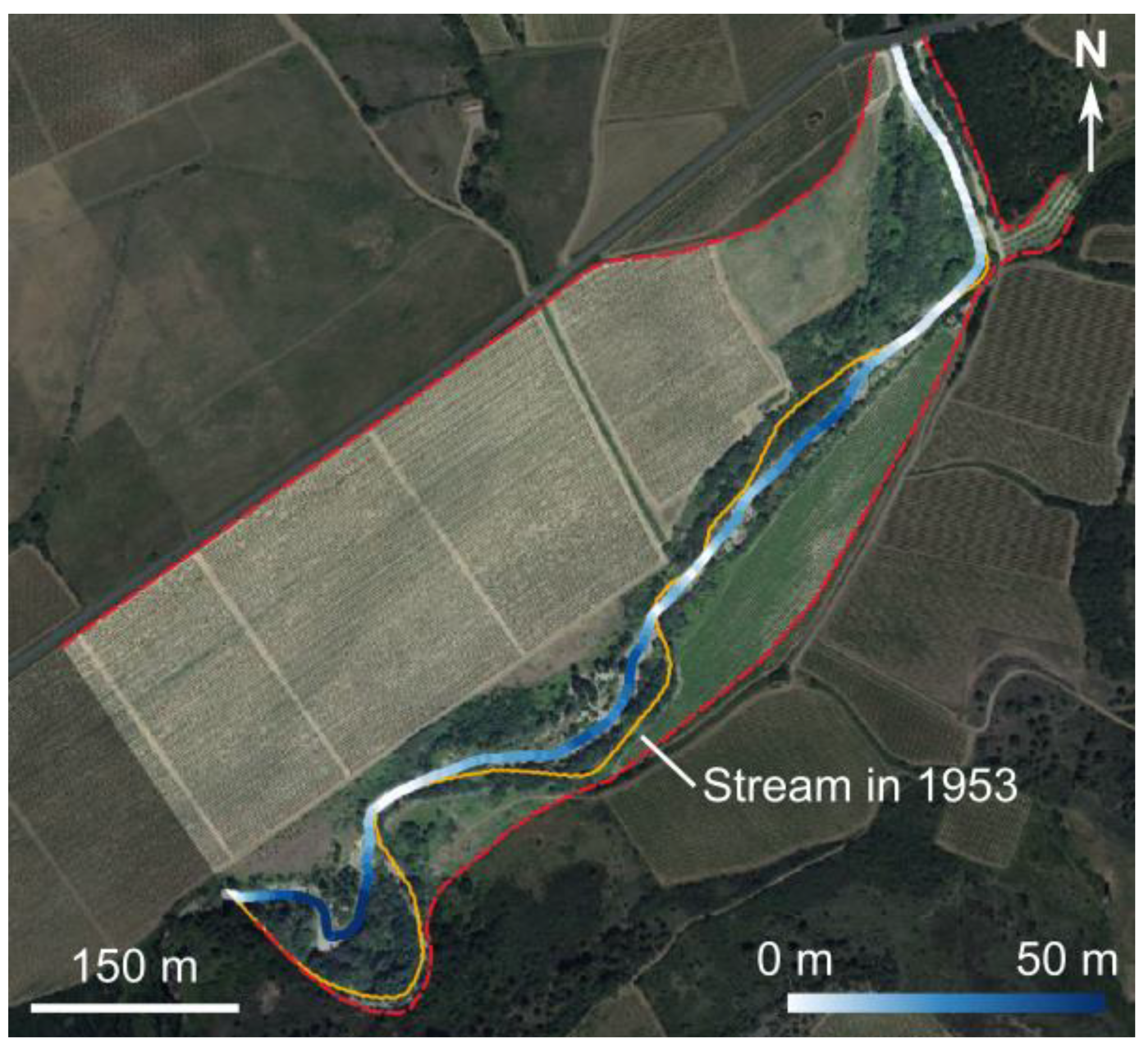
3.2.3. Indicator 3: Diachronic Distance
3.3. The Metric Analysis Grid Approach
4. Discussion
4.1. New Indicators
4.2. The Metric Analysis Grid in the Two-Dimensional Euclidean Space
5. Conclusions
Author Contributions
Funding
Acknowledgments
Conflicts of Interest
References
- Arnaud-Fassetta, G.; Beltrando, G.; Fort, M.; Plet, A.; André, G.; Clément, D.; Dagan, M.; Méring, C.; Quisserne, D.; Rycx, Y. La catastrophe hydrologique de novembre 1999 dans le bassin-versant de l’Argent Double (Aude, France): De l’aléa pluviométrique à la gestion des risques pluviaux et fluviaux. Géomorphol. Relief Process. Environ. 2002, 8, 17–34. [Google Scholar] [CrossRef]
- Brousse, G. Efficacité des Travaux de Restauration et Résilience des Rivières Torrentielles Altérées. Ph.D. Thesis, University of Paris, Paris, France, 2020. [Google Scholar]
- Arnaud-Fassetta, G.; Fort, M. Hydro-bio-morphological changes and control factors of an upper Alpine valley bottom since the mid-19th century. Case study of the Guil River, Durance catchment, southern French Alps. Méditerranée 2014, 122, 159–182. [Google Scholar] [CrossRef]
- Brousse, G.; Arnaud-Fassetta, G.; Cordier, S. Évolution hydrogéomorphologique de la bande active de l’Ubaye (Alpes françaises du Sud) de 1956 à 2004: Contribution à la gestion des crues. Géomorphol. Relief Process. Environ. 2011, 17, 307–318. [Google Scholar] [CrossRef] [Green Version]
- Burkham, D.E. Channel Changes of the Gila River in Safford Valley, Arizona, 1846–1970; Professional Paper 655-G; US Geological Survey: Washington, DC, USA, 1972; 24p. [Google Scholar]
- Yu, B. The hydrological and geomorphological impacts of the Tinaroo Falls Dam on the Barron River, North Queensland, Australia. In River Management. The Australasian Experience; Brizga, S., Finlayson, B., Eds.; Wiley: Chichester, UK, 2000; pp. 73–95. [Google Scholar]
- Erskine, W.D.; Warner, R.F. Geomorphic effects of alternating flood and drought dominated regimes on NSW coastal rivers. In Fluvial Geomorphology of Australia; Warner, R.F., Ed.; Academic Press: Sydney, Australia, 1988; pp. 223–244. [Google Scholar]
- Brooks, A.P.; Brierley, G.J. The role of European disturbance in the metamorphosis of the lower Bega River. In River Management. The Australasian Experience; Brizga, S., Finlayson, B., Eds.; Wiley: Chichester, UK, 2000; pp. 221–246. [Google Scholar]
- Hohensinner, S.; Habersack, H.; Jungwirth, M.; Zauner, G. Reconstruction of the characteristics of a natural alluvial river-floodplain system and hydromorphological changes following human modifications: The Danube River (1812–1991). River Res. Appl. 2004, 20, 25–41. [Google Scholar] [CrossRef]
- Miramont, C.; Jorda, M.; Pichard, G. Évolution historique de la morphogenèse et de la dynamique fluviale d’une rivière méditerranéenne: l’exemple de la Moyenne Durance (France du Sud-est). Géogr. Phys. Quat. 1998, 52, 381–392. [Google Scholar] [CrossRef] [Green Version]
- Laigre, L.; Arnaud-Fassetta, G.; Reynard, E. Cartographie sectorielle du paléoenvironnement de la plaine alluviale du Rhône suisse depuis la fin du Petit Âge Glaciaire: La métamorphose fluviale de Viège à Rarogne et de Sierre à Sion. Bull. Murithienne 2009, 127, 7–17. [Google Scholar]
- Arnaud-Fassetta, G. River channel changes in the Rhone Delta (France) since the end of the Little Ice Age: Geomorphological adjustment to hydroclimatic change and natural resource management. Catena 2003, 51, 141–172. [Google Scholar] [CrossRef]
- Bravard, J.-P.; Provansal, M.; Arnaud-Fassetta, G.; Chabbert, S.; Gaydou, P.; Dufour, S.; Richard, F.; Valleteau, S.; Melun, G.; Passy, P. Un atlas du paléo-environnement de la plaine alluviale du Rhône de la frontière suisse à la mer. Édytem 2008, 6, 101–116. [Google Scholar] [CrossRef]
- Cubizolle, H. La morphodynamique fluviale dans ses rapports avec les aménagements hydrauliques: l’exemple de la Dore au XXe siècle (Massif Central, France). Géomorphol. Relief Process. Environ. 1996, 1, 67–82. [Google Scholar] [CrossRef]
- Peiry, J.-L.; Pupier, N. La notion de lit fluvial sur les rivières alpines et méditerranéennes et ses implications pour la gestion du chenal. Études Vauclus. 1994, 5, 51–57. [Google Scholar]
- Gautier, E.; Piégay, H.; Bertaina, P. A methodological approach of fluvial dynamics oriented towards hydrosystem management: Case study of the Loire and Allier rivers. Geodin. Acta 2000, 1, 29–43. [Google Scholar] [CrossRef] [Green Version]
- Peiry, J.-L.; Nouguier, F. Le Drac dans l’agglomération de Grenoble: Première évaluation des changements géomorphologiques contemporains. Rev. Géogr. Alp. 1994, 2, 77–96. [Google Scholar] [CrossRef]
- Liébault, F.; Piégay, H. Causes of 20th century channel narrowing in mountain and piedmont rivers of southeastern France. Earth Surf. Process. Landf. 2002, 27, 425–444. [Google Scholar] [CrossRef]
- Siché, I.; Arnaud-Fassetta, G. Anthropogenic actions since the end of the Little Ice Age: A critical factor controlling the last ‘fluvial metamorphosis’ of the Isonzo River (Italy, Slovenia). Méditerranée 2014, 122, 183–200. [Google Scholar] [CrossRef] [Green Version]
- Descroix, L.; Gautier, E. Water erosion in the southern French alps: Climatic and human mechanisms. Catena 2002, 50, 53–85. [Google Scholar] [CrossRef]
- Salit, F.; Arnaud-Fassetta, G.; Zaharia, L.; Madelin, M.; Beltrando, G. The influence of river training on channel changes during the 20th century in the Lower Siret River, Danube catchment (Romania). Géomorphol. Relief Process. Environ. 2015, 21, 175–188. [Google Scholar] [CrossRef]
- Brierley, G.J.; Fitchett, K. Channel planform adjustments along the Waiau River, 1946-1992: Assessment of the impacts of flow regulation. In River Management. The Australasian Experience; Brizga, S., Finlayson, B., Eds.; Wiley: Chichester, UK, 2000; pp. 51–71. [Google Scholar]
- Piégay, H.; Salvador, P.-G.; Astrade, L. Réflexions relatives à la variabilité spatiale de la mosaïque fluviale à l’échelle du tronçon. Z. Für Geomorphol. 2000, 44, 317–342. [Google Scholar]
- Gilvear, D.J. Patterns of channel adjustment to impoundment of the upper River Spey, Scotland(1942–2000). River Res. Appl. 2003, 20, 151–165. [Google Scholar] [CrossRef]
- Lescure, S.; Arnaud-Fassetta, G.; Cordier, S. Sur quelques modifications hydromorphologiques dans le Val de Seine (Bassin parisien, France) depuis 1830: Quelle part accorder aux facteurs hydrologiques et anthropiques? EchoGeo 2011, 18, 15. [Google Scholar] [CrossRef] [Green Version]
- Alaoui, K. Les Modifications Hydro-Morphodynamiques dans la Plaine Alluviale aval de l’Yerres Sous L’influence de L’anthropisation. Master’s Thesis, University Denis-Diderot, Paris, France, 2000. [Google Scholar]
- Melun, G. Impacts Environnementaux de la Suppression des Ouvrages Hydrauliques dans le Cadre du Rétablissement de la Continuité des Cours D’eau Imposée par la Loi sur L’eau et les Milieux Aquatiques. Ph.D. Thesis, University Paris-Diderot, Paris, France, 2012. [Google Scholar]
- Michler, L. Impacts Hydromorphologiques et Sédimentaires du Décloisonnement de l’Yerres. Identification, Quantification, Spatialisation. Ph.D. Thesis, University Paris-Diderot, Paris, France, 2018. [Google Scholar]
- Bennett, S.J.; Simon, A.; Castro, J.M.; Atkinson, J.F.; Bronner, C.E.; Blersch, S.S.; Rabideau, A.J. The evolving science of stream restoration. In Stream Restoration in Dynamic Fluvial Systems: Scientific Approaches, Analyses, and Tools; Geophysical, Monograph; Simon, A., Bennett, S.J., Castro, J.M., Eds.; American Geophysical Union: Washington, DC, USA, 2011; Volume 194, pp. 1–8. [Google Scholar]
- Wohl, E.; Lane, S.N.; Wilcox, A.C. The science and practice of river restoration. Water Resour. Res. 2015, 51, 5974–5997. [Google Scholar] [CrossRef] [Green Version]
- Morandi, B.; Piégay, H. La Restauration des Cours d’eau en France: Comment les Définitions et les Pratiques Ont-Elles Evolué Dans le Temps et Dans L’espace, Quelles Pistes D’action Pour le Futur? Agence Française pour la Biodiversité, Collection Comprendre pour agir: Paris, France, 2017; 28p. [Google Scholar]
- Malavoi, J.-P.; Bravard, J.-P.; Piégay, H.; Heroin, E.; Ramez, P. Détermination de L’espace de Liberté des Cours D’eau, SDAGE Rhône Méditerranée Corse, Guide Technique 2; France. 1998; 42p.
- Dufour, S.; Piégay, H. From the myth of a lost paradise to targeted river restoration: Forget natural references and focus on human benefits. River Res. Appl. 2009, 25, 568–581. [Google Scholar] [CrossRef]
- Morandi, B. La Restauration des Cours d’eau en France et à L’étranger: De la Définition du Concept à L’évaluation de L’action. Éléments de Recherche Applicables. Ph.D. Thesis, ENS Lyon, Lyon, France, 2014. [Google Scholar]
- Brookes, A. Channelized Rivers: Perspectives for Environmental Management; Wiley: Chichester, UK, 1988; 342p. [Google Scholar]
- Wasson, J.-G.; Malavoi, J.-R.; Maridet, L.; Souchon, Y.; Paulin, L. Impacts Ecologiques de la Chenalisation des Rivières; CEMAGREF Éditions, Collection «Études», Gestion des Milieux Aquatiques 14; CEMAGREF: Antony, France, 1998; 158p. [Google Scholar]
- Adam, P.; Debiais, N.; Malavoi, J.-R. Manuel de Restauration Hydromorphologique des Cours D’eau; Agence de l’eau Seine Normandie: Nanterre, France, 2007; 62p. [Google Scholar]
- Kondolf, M.G.; Piégay, H. Tools in Fluvial Geomorphology; Wiley: Chichester, UK, 2003; 696p. [Google Scholar]
- Lallias-Tacon, S. Analyse Spatio-Temporelle de la Morphologie des Rivières en Tresses par LiDAR Aéroporté. Ph.D. Thesis, University Lyon 2, Lyon, France, 2015. [Google Scholar]
- Michez, A.; Piégay, H.; Lejeune, P.; Claessens, H. Multi-temporal monitoring of a regional riparian buffer network (>12,000 km) with LiDAR and photogrammetric point clouds. J. Environ. Manag. 2017, 202, 424–436. [Google Scholar] [CrossRef]
- Bizzi, S.; Piégay, H.; Demarchi, L.; van de Bund, W.; Weissteiner, C.J.; Gob, F. LiDAR-based fluvial remote sensing to assess 50-100-year human-driven channel changes at a regional level: The case of the Piedmont Region, Italy. Earth Surf. Process. Landf. 2019, 44, 471–489. [Google Scholar] [CrossRef]
- Brousse, G.; Arnaud-Fassetta, G.; Liébault, F.; Bertrand, M.; Melun, G.; Loire, R.; Malavoi, J.; Fantino, G.; Borgniet, L. Channel response to sediment replenishment in a large gravel-bed river: The case of the Saint-Sauveur dam in the Buëch River (Southern Alps, France). River Res. Appl. 2020, 36, 880–893. [Google Scholar] [CrossRef]
- Brousse, G.; Liébault, F.; Arnaud-Fassetta, G.; Breilh, B.; Tacon, S. Gravel replenishment and active-channel widening for braided-river restoration: The case of the Upper Drac River (France). Sci. Total. Environ. 2021, 766, 142517. [Google Scholar] [CrossRef]
- QGIS.org. QGIS Geographic Information System; QGIS Association: Grüt, Zürich, Switzerland, 2021; Available online: http://www.qgis.org (accessed on 16 July 2021).
- GDAL/OGR Contributors. GDAL/OGR Geospatial Data Abstraction Software Library; Open-Source Geospatial Foundation: Beaverton, OR, USA, 2021; Available online: https://gdal.org (accessed on 15 July 2021).
- Arnaud-Fassetta, G. L’hydrogéomorphologie Fluviale, des Hauts Bassins Montagnards aux Plaines Côtières: Entre Géographie des Risques, Géarchéologie et Géosciences. Ph.D. Thesis, University Paris-Diderot, Paris, France, 2007. [Google Scholar]
- Brice, J.C. Channel Patterns and Terraces of the Loup River in Nebraska; Professional Paper 422-D; US Geological Survey: Washington, DC, USA, 1964; 41p. [Google Scholar]
- Howard, A.D.; Keetch, M.E.; Vincent, C.L. Topological and geomorphic properties of braided streams. Water Resour. Res. 1970, 6, 1647–1688. [Google Scholar] [CrossRef]
- Montgomery, D.R.; Buffington, J.M. Channel-reach morphology in mountain drainage basins. Geol. Soc. Am. Bull. 1997, 109, 596–611. [Google Scholar] [CrossRef]
- Fort, M.; Arnaud-Fassetta, G.; Beltrando, G.; Plet, A.; André, G.; Mering, C. Impacts hydromorphologiques des fortes précipitations des 12–13 novembre 1999 sur la retombée méridionale de la Montagne Noire: l’exemple de l’Argent Double (Aude). In Au Chevet D’une Catastrophe. Les Inondations des 12 et 13 Novembre 1999 dans le Sud de la France. Actes du Colloque de Perpignan, 26–28 Juin 2000; Médi-Terra, Ed.; Presses Universitaires de Perpignan: Perpignan, France, 2001; pp. 41–52. [Google Scholar]
- Plet, A.; Arnaud-Fassetta, G.; Beltrando, G.; Fort, M. Contraintes hydrologiques et gestion des territoires dans le Minervois. Retour d’expérience après la crue de novembre 1999. In Actes du Colloque « Hydrosystèmes, Paysages, Territoires », 6–8 Septembre 2001, Lille, Commission des Hydrosystèmes Continentaux du Comité National Français de Géographie; CD-rom: Lille, France, 2002. [Google Scholar]
- Arnaud-Fassetta, G.; Fort, M. The integration of space of good functionment in fluvial geomorphology, as a tool for mitigating flood risk. Application to the left-bank tributaries of the Aude River, Mediterranean France. In IVth ECRR International Conference on River Restoration 2008; Gumiero, B., Rinaldi, M., Fokkens, B., Eds.; Centro Italiano per la Riqualificazione Fluviale: Mestre, Italy, 2009; pp. 313–322. [Google Scholar]
- Arnaud-Fassetta, G.; Fort, M. Dix ans de recherches hydrogéomorphologiques dans le département de l’Aude et une question: Comment parvenir à réduire le risque de crue en domaine méditerranéen? In Actes du Colloque International «Risques Naturels en Méditerranée Occidentale» 16–21 Novembre 2009, Carcassonne, France; Fort, M., Ogé, F., Eds.; Reproduction Héliographique Audoise: Carcassonne, France, 2011; pp. 33–52. [Google Scholar]
- Michler, L.; Brousse, G.; Arnaud-Fassetta, G.; Carozza, J.-M.; Paris-Diderot Team. Dynamique de la charge de fond de l’Argent Double (affluent de rive gauche de l’Aude, France du Sud): Approche croisée «Technologie RFID/modélisation numérique du transport solide». Bull. Soc. Géogr. Liège 2016, 67, 59–75. [Google Scholar]


| Stage 1 | Before Significant Functionalization of Rivers (<18th–19th century) | |
|---|---|---|
| Channel lengthening/shortening | ||
| High-energy rivers (ω > 30 W/m2) | ++ | |
| Low-energy rivers (ω < 30 W/m2) | - | |
| Stage 2 | Before Embankment Removal Associated to River Restoration | |
| Channel lengthening/shortening | ||
| Natural context (not constricted) | Artificialized context (channelized) | |
| High-energy rivers (ω > 30 W/m2) | ++ | o |
| Low-energy rivers (ω < 30 W/m2) | - | o |
| Stage 3 | After Embankment Removal Accompanying River Restoration | |
| Channel lengthening/shortening | ||
| Natural context (not constricted) | Artificialized context (channelized) | |
| High-energy rivers (ω > 30 W/m2) | ++ | +/++ |
| Low-energy rivers (ω < 30 W/m2) | - | - |
| A | Lateral Mobility Rate (LMR) | |
|---|---|---|
| Left bank | Right bank | |
| Number of cells with geomorphological change (ngc) | 28 | 22 |
| Number of cells counted in X-axis (n) | 40 | 40 |
| LMR (in %) | 70 | 55 |
| B | Braided Index (BI) | |
| Year A | 0.65 | |
| Year B | 0.75 | |
| BI evolution (in %) | 13.3 | |
| Lateral Mobility Rate (LMR) | ||
|---|---|---|
| Left bank | Right bank | |
| Number of cells with morphological change (ngc) | 190 | 201 |
| Number of cells counted in X-axis (n) | 206 | 206 |
| LMR (in %) | 92 | 98 |
Publisher’s Note: MDPI stays neutral with regard to jurisdictional claims in published maps and institutional affiliations. |
© 2021 by the authors. Licensee MDPI, Basel, Switzerland. This article is an open access article distributed under the terms and conditions of the Creative Commons Attribution (CC BY) license (https://creativecommons.org/licenses/by/4.0/).
Share and Cite
Arnaud-Fassetta, G.; Melun, G.; Passy, P.; Brousse, G.; Theureaux, O. How to Quantify the Dynamics of Single (Straight or Sinuous) and Multiple (Anabranching) Channels from Imagery for River Restoration. Appl. Sci. 2021, 11, 8075. https://doi.org/10.3390/app11178075
Arnaud-Fassetta G, Melun G, Passy P, Brousse G, Theureaux O. How to Quantify the Dynamics of Single (Straight or Sinuous) and Multiple (Anabranching) Channels from Imagery for River Restoration. Applied Sciences. 2021; 11(17):8075. https://doi.org/10.3390/app11178075
Chicago/Turabian StyleArnaud-Fassetta, Gilles, Gabriel Melun, Paul Passy, Guillaume Brousse, and Olivier Theureaux. 2021. "How to Quantify the Dynamics of Single (Straight or Sinuous) and Multiple (Anabranching) Channels from Imagery for River Restoration" Applied Sciences 11, no. 17: 8075. https://doi.org/10.3390/app11178075
APA StyleArnaud-Fassetta, G., Melun, G., Passy, P., Brousse, G., & Theureaux, O. (2021). How to Quantify the Dynamics of Single (Straight or Sinuous) and Multiple (Anabranching) Channels from Imagery for River Restoration. Applied Sciences, 11(17), 8075. https://doi.org/10.3390/app11178075