

Estimation of Nitrogen Content in Winter Wheat Based on Multi-Source Data Fusion and Machine Learning
Abstract
:1. Introduction
2. Materials and Methods
2.1. Site Description and Experimental Design
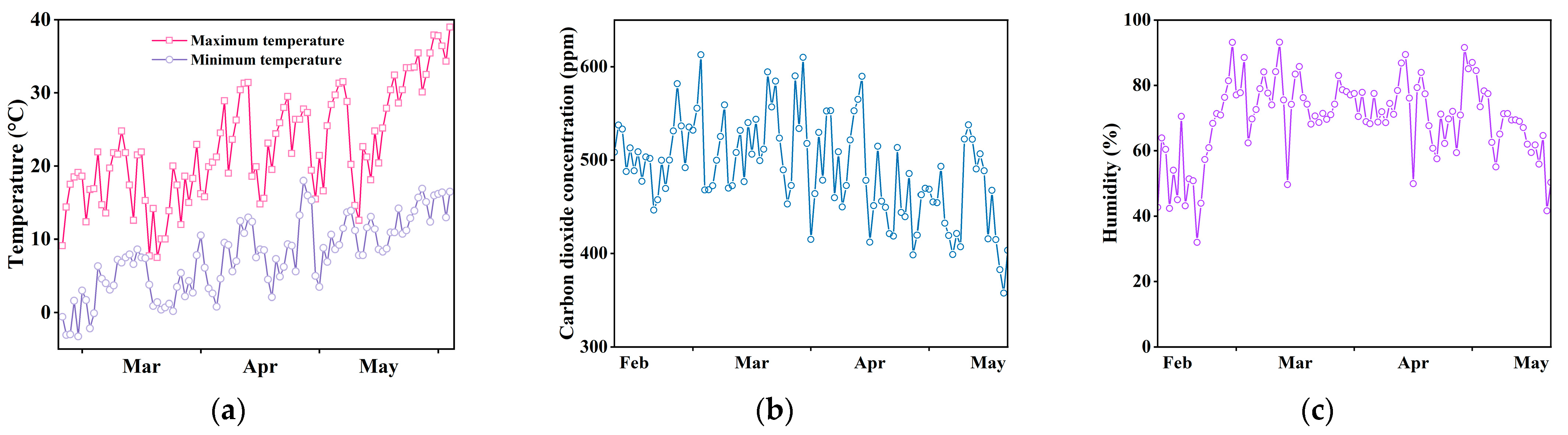
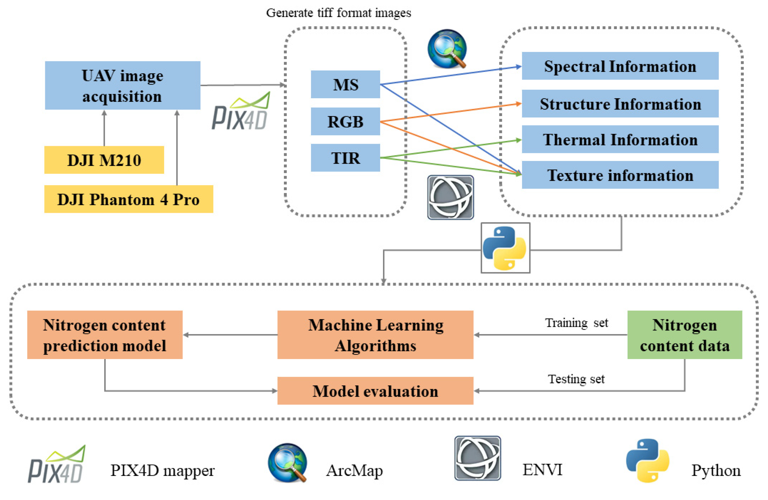
2.2. Data Acquisition
2.2.1. Field Data Acquisition
2.2.2. UAV Data Acquisition
2.2.3. Image Preprocessing
2.3. Multimodal UAV Information Extraction
2.3.1. Canopy Spectral Information
2.3.2. Canopy Structure Information
2.3.3. Canopy Thermal Information
2.3.4. Texture Features
2.4. Machine Learning Methods
3. Results
3.1. Relationship between CSC and N Content of Winter Wheat
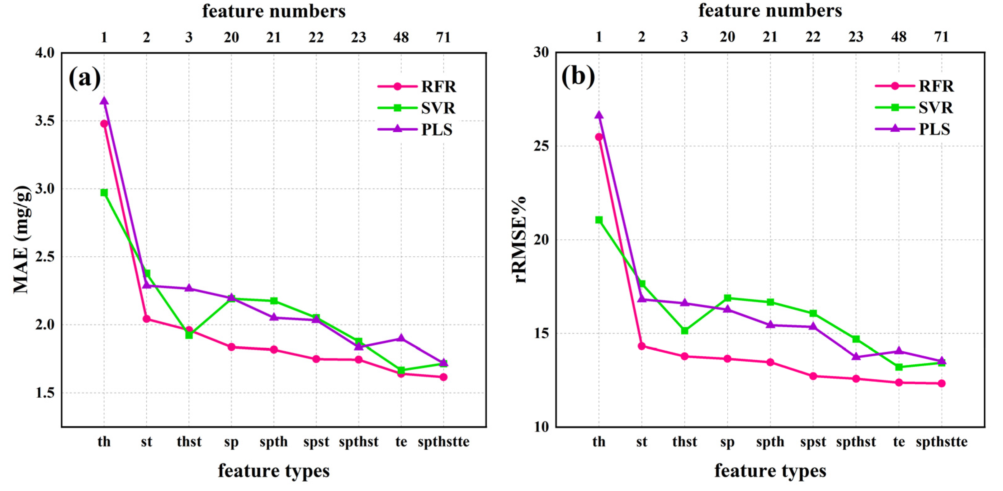
3.2. Estimation of N Content under a Single Data Source
3.3. N Content Estimation by Fusing Multiple-Source Data
4. Discussion
4.1. Relationship between Drone Images and N Levels
4.2. Relationship between CSC and N Content
4.3. Limitations and Implications of the Study
5. Conclusions
Author Contributions
Funding
Conflicts of Interest
References
- Lin, M.Y.; Lynch, V.; Ma, D.D.; Maki, H.; Jin, J.; Tuinstra, M. Multi-Species Prediction of Physiological Traits with Hyperspectral Modeling. Plants 2022, 11, 15. [Google Scholar] [CrossRef] [PubMed]
- Wang, Z.L.; Chen, J.X.; Zhang, J.W.; Fan, Y.F.; Cheng, Y.J.; Wang, B.B.; Wu, X.L.; Tan, X.M.; Tan, T.T.; Li, S.L.; et al. Predicting grain yield and protein content using canopy reflectance in maize grown under different water and nitrogen levels. Field Crops Res. 2021, 260, 15. [Google Scholar] [CrossRef]
- Calderon, R.; Rajendiran, K.; Kim, U.J.; Palma, P.; Arancibia-Miranda, N.; Silva-Moreno, E.; Corradini, F. Sources and fates of perchlorate in soils in Chile: A case study of perchlorate dynamics in soil-crop systems using lettuce (Lactuca sativa) fields. Environ. Pollut. 2020, 264, 7. [Google Scholar] [CrossRef] [PubMed]
- Osco, L.P.; Ramos, A.P.M.; Pereira, D.R.; Moriya, E.A.S.; Imai, N.N.; Matsubara, E.T.; Estrabis, N.; de Souza, M.; Marcato, J.; Goncalves, W.N.; et al. Predicting Canopy Nitrogen Content in Citrus-Trees Using Random Forest Algorithm Associated to Spectral Vegetation Indices from UAV-Imagery. Remote Sens. 2019, 11, 2925. [Google Scholar] [CrossRef] [Green Version]
- Goffart, D.; Ben Abdallah, F.; Curnel, Y.; Planchon, V.; Defourny, P.; Goffart, J.P. In-Season Potato Crop Nitrogen Status Assessment from Satellite and Meteorological Data. Potato Res. 2022, 65, 729–755. [Google Scholar] [CrossRef]
- Bossung, C.; Schlerf, M.; Machwitz, M. Estimation of canopy nitrogen content in winter wheat from Sentinel-2 images for operational agricultural monitoring. Precis. Agric. 2022, 1–24. [Google Scholar] [CrossRef]
- Iatrou, M.; Karydas, C.; Iatrou, G.; Pitsiorlas, I.; Aschonitis, V.; Raptis, I.; Mpetas, S.; Kravvas, K.; Mourelatos, S. Topdressing Nitrogen Demand Prediction in Rice Crop Using Machine Learning Systems. Agriculture 2021, 11, 312. [Google Scholar] [CrossRef]
- Berger, K.; Verrelst, J.; Feret, J.B.; Hank, T.; Wocher, M.; Mauser, W.; Camps-Valls, G. Retrieval of aboveground crop nitrogen content with a hybrid machine learning method. Int. J. Appl. Earth Obs. Geoinf. 2020, 92, 15. [Google Scholar] [CrossRef]
- Yu, D.Y.; Zha, Y.Y.; Sun, Z.G.; Li, J.; Jin, X.L.; Zhu, W.X.; Bian, J.; Ma, L.; Zeng, Y.J.; Su, Z.B. Deep convolutional neural networks for estimating maize above-ground biomass using multi-source UAV images: A comparison with traditional machine learning algorithms. Precis. Agric. 2022, 1–22. [Google Scholar] [CrossRef]
- Revill, A.; Florence, A.; MacArthur, A.; Hoad, S.; Rees, R.; Williams, M. Quantifying Uncertainty and Bridging the Scaling Gap in the Retrieval of Leaf Area Index by Coupling Sentinel-2 and UAV Observations. Remote Sens. 2020, 12, 1843. [Google Scholar] [CrossRef]
- Hasan, U.; Sawut, M.; Chen, S.S. Estimating the Leaf Area Index of Winter Wheat Based on Unmanned Aerial Vehicle RGB-Image Parameters. Sustainability 2019, 11, 6829. [Google Scholar] [CrossRef] [Green Version]
- Maimaitijiang, M.; Sagan, V.; Sidike, P.; Hartling, S.; Esposito, F.; Fritschi, F.B. Soybean yield prediction from UAV using multimodal data fusion and deep learning. Remote Sens. Environ. 2020, 237, 20. [Google Scholar] [CrossRef]
- Fu, Z.P.; Jiang, J.; Gao, Y.; Krienke, B.; Wang, M.; Zhong, K.T.; Cao, Q.; Tian, Y.C.; Zhu, Y.; Cao, W.X.; et al. Wheat Growth Monitoring and Yield Estimation based on Multi-Rotor Unmanned Aerial Vehicle. Remote Sens. 2020, 12, 508. [Google Scholar] [CrossRef] [Green Version]
- Berger, K.; Verrelst, J.; Feret, J.B.; Wang, Z.H.; Wocher, M.; Strathmann, M.; Danner, M.; Mauser, W.; Hank, T. Crop nitrogen monitoring: Recent progress and principal developments in the context of imaging spectroscopy missions. Remote Sens. Environ. 2020, 242, 18. [Google Scholar] [CrossRef] [PubMed]
- Han, W.; Tang, J.; Zhang, L.; Niu, Y.; Wang, T. Maize Water Use Efficiency and Biomass Estimation Based on Unmanned Aerial Vehicle Remote Sensing. Trans. Chin. Soc. Agric. Mach. 2021, 52, 129–141. [Google Scholar]
- Li, C.C.; Cui, Y.Q.; Ma, C.Y.; Niu, Q.L.; Li, J.B. Hyperspectral inversion of maize biomass coupled with plant height data. Crop Sci. 2021, 61, 2067–2079. [Google Scholar] [CrossRef]
- Tao, H.; Xu, L.; Feng, H.; Yang, G.; Dai, Y.; Niu, Y. Estimation of Plant Height and Leaf Area Index of Winter Wheat Based on UAV Hyperspectral Remote Sensing. Trans. Chin. Soc. Agric. Mach. 2020, 51, 193–201. [Google Scholar]
- Zhang, X.W.; Zhang, K.F.; Sun, Y.Q.; Zhao, Y.D.; Zhuang, H.F.; Ban, W.; Chen, Y.; Fu, E.R.; Chen, S.; Liu, J.X.; et al. Combining Spectral and Texture Features of UAS-Based Multispectral Images for Maize Leaf Area Index Estimation. Remote Sens. 2022, 14, 331. [Google Scholar] [CrossRef]
- Hassan, M.A.; Yang, M.J.; Rasheed, A.; Jin, X.L.; Xia, X.C.; Xiao, Y.G.; He, Z.H. Time-Series Multispectral Indices from Unmanned Aerial Vehicle Imagery Reveal Senescence Rate in Bread Wheat. Remote Sens. 2018, 10, 809. [Google Scholar] [CrossRef] [Green Version]
- Panek, E.; Gozdowski, D.; Stepien, M.; Samborski, S.; Rucinski, D.; Buszke, B. Within-Field Relationships between Satellite-Derived Vegetation Indices, Grain Yield and Spike Number of Winter Wheat and Triticale. Agronomy 2020, 10, 1842. [Google Scholar] [CrossRef]
- Yang, B.H.; Zhu, Y.; Zhou, S.J. Accurate Wheat Lodging Extraction from Multi-Channel UAV Images Using a Lightweight Network Model. Sensors 2021, 21, 16. [Google Scholar] [CrossRef]
- Walter, J.D.C.; Edwards, J.; McDonald, G.; Kuchel, H. Estimating Biomass and Canopy Height with LiDAR for Field Crop Breeding. Front. Plant Sci. 2019, 10, 16. [Google Scholar] [CrossRef] [PubMed] [Green Version]
- Gilliot, J.M.; Michelin, J.; Hadjard, D.; Houot, S. An accurate method for predicting spatial variability of maize yield from UAV-based plant height estimation: A tool for monitoring agronomic field experiments. Precis. Agric. 2021, 22, 897–921. [Google Scholar] [CrossRef]
- Wang, Y.; Fang, H.L. Estimation of LAI with the LiDAR Technology: A Review. Remote Sens. 2020, 12, 3457. [Google Scholar] [CrossRef]
- Shendryk, Y.; Sofonia, J.; Garrard, R.; Rist, Y.; Skocaj, D.; Thorburn, P. Fine-scale prediction of biomass and leaf nitrogen content in sugarcane using UAV LiDAR and multispectral imaging. Int. J. Appl. Earth Obs. Geoinf. 2020, 92, 14. [Google Scholar] [CrossRef]
- Elsayed, S.; Elhoweity, M.; Ibrahim, H.H.; Dewir, Y.H.; Migdadi, H.M.; Schmidhalter, U. Thermal imaging and passive reflectance sensing to estimate the water status and grain yield of wheat under different irrigation regimes. Agric. Water Manag. 2017, 189, 98–110. [Google Scholar] [CrossRef]
- Pancorbo, J.L.; Camino, C.; Alonso-Ayuso, M.; Raya-Sereno, M.D.; Gonzalez-Fernandez, I.; Gabriel, J.L.; Zarco-Tejada, P.J.; Quemada, M. Simultaneous assessment of nitrogen and water status in winter wheat using hyperspectral and thermal sensors. Eur. J. Agron. 2021, 127, 14. [Google Scholar] [CrossRef]
- Fu, Y.Y.; Yang, G.J.; Song, X.Y.; Li, Z.H.; Xu, X.G.; Feng, H.K.; Zhao, C.J. Improved Estimation of Winter Wheat Aboveground Biomass Using Multiscale Textures Extracted from UAV-Based Digital Images and Hyperspectral Feature Analysis. Remote Sens. 2021, 13, 581. [Google Scholar] [CrossRef]
- Fei, S.P.; Hassan, M.A.; Xiao, Y.G.; Su, X.; Chen, Z.; Cheng, Q.; Duan, F.Y.; Chen, R.Q.; Ma, Y.T. UAV-based multi-sensor data fusion and machine learning algorithm for yield prediction in wheat. Precis. Agric. 2022, 26. [Google Scholar] [CrossRef]
- Tucker, C.J. Red and photographic infrared linear combinations for monitoring vegetation. Remote Sens. Environ. 1979, 8, 127–150. [Google Scholar] [CrossRef] [Green Version]
- Steven, M.D. The sensitivity of the OSAVI vegetation index to observational parameters. Remote Sens. Environ. 1998, 63, 49–60. [Google Scholar] [CrossRef]
- Hatfield, J.L.; Prueger, J.H. Value of Using Different Vegetative Indices to Quantify Agricultural Crop Characteristics at Different Growth Stages under Varying Management Practices. Remote Sens. 2010, 2, 562–578. [Google Scholar] [CrossRef]
- Qi, J.; Chehbouni, A.; Huete, A.R.; Kerr, Y.H.; Sorooshian, S. A modified soil adjusted vegetation index. Remote Sens. Environ. 1994, 48, 119–126. [Google Scholar] [CrossRef]
- Candiago, S.; Remondino, F.; De Giglio, M.; Dubbini, M.; Gattelli, M. Evaluating Multispectral Images and Vegetation Indices for Precision Farming Applications from UAV Images. Remote Sens. 2015, 7, 4026–4047. [Google Scholar] [CrossRef] [Green Version]
- Broge, N.H.; Mortensen, J.V. Deriving green crop area index and canopy chlorophyll density of winter wheat from spectral reflectance data. Remote Sens. Environ. 2002, 81, 45–57. [Google Scholar] [CrossRef]
- Gitelson, A.A.; Vina, A.; Ciganda, V.; Rundquist, D.C.; Arkebauer, T.J. Remote estimation of canopy chlorophyll content in crops. Geophys. Res. Lett. 2005, 32, 4. [Google Scholar] [CrossRef] [Green Version]
- Bendig, J.; Yu, K.; Aasen, H.; Bolten, A.; Bennertz, S.; Broscheit, J.; Gnyp, M.L.; Bareth, G. Combining UAV-based plant height from crop surface models, visible, and near infrared vegetation indices for biomass monitoring in barley. Int. J. Appl. Earth Obs. Geoinf. 2015, 39, 79–87. [Google Scholar] [CrossRef]
- Potgieter, A.B.; George-Jaeggli, B.; Chapman, S.C.; Laws, K.; Cadavid, L.A.S.; Wixted, J.; Watson, J.; Eldridge, M.; Jordan, D.R.; Hammer, G.L. Multi-Spectral Imaging from an Unmanned Aerial Vehicle Enables the Assessment of Seasonal Leaf Area Dynamics of Sorghum Breeding Lines. Front. Plant Sci. 2017, 8, 11. [Google Scholar] [CrossRef]
- Ballester, C.; Hornbuckle, J.; Brinkhoff, J.; Smith, J.; Quayle, W. Assessment of In-Season Cotton Nitrogen Status and Lint Yield Prediction from Unmanned Aerial System Imagery. Remote Sens. 2017, 9, 1149. [Google Scholar] [CrossRef] [Green Version]
- Dempewolf, J.; Adusei, B.; Becker-Reshef, I.; Hansen, M.; Potapov, P.; Khan, A.; Barker, B. Wheat Yield Forecasting for Punjab Province from Vegetation Index Time Series and Historic Crop Statistics. Remote Sens. 2014, 6, 9653–9675. [Google Scholar] [CrossRef] [Green Version]
- Wu, H.; Cui, K.; Zhang, X.; Xue, X.; Zheng, W.; Wang, Y. Improving Accuracy of Fine Leaf Crop Coverage by Improved K-means Algorithm. Trans. Chin. Soc. Agric. Mach. 2019, 50, 42–50. [Google Scholar]
- Qiao, L.; Tang, W.J.; Gao, D.H.; Zhao, R.M.; An, L.L.; Li, M.Z.; Sun, H.; Song, D. UAV-based chlorophyll content estimation by evaluating vegetation index responses under different crop coverages. Comput. Electron. Agric. 2022, 196, 12. [Google Scholar] [CrossRef]
- Kang, Y.P.; Meng, Q.Y.; Liu, M.; Zou, Y.F.; Wang, X.M. Crop Classification Based on Red Edge Features Analysis of GF-6 WFV Data. Sensors 2021, 21, 4328. [Google Scholar] [CrossRef] [PubMed]
- Shuai, S.; Zhang, Z.; Lyu, X.; Chen, S.; Ma, Z.; Xie, C. Remote sensing monitoring of vegetation phenological characteristics and vegetation health status in mine restoration areas. Trans. Chin. Soc. Agric. Eng. 2021, 37, 224–234. [Google Scholar]
- Yin, L.; Zhou, Z.; Li, S.; Huang, D. Research on Vegetation Extraction and Fractional Vegetation Cover of Karst Area Based on Visible Light Image of UAV. Acta Agrestia Sin. 2020, 28, 1664–1672. [Google Scholar]
- Li, B.; Liu, R.; Liu, S.; Liu, Q.; Liu, F.; Zhou, G. Monitoring vegetation coverage variation of winter wheat by low-altitude UAV remote sensing system. Trans. Chin. Soc. Agric. Eng. 2012, 28, 160–165. [Google Scholar]
- Liu, Z.; Huang, J.; Wu, X.; Dong, Y.; Wang, F.; Liu, P. Hyperspectral remote sensing estimation models on vegetation coverage of natural grassland. Ying Yong Sheng Tai Xue Bao = J. Appl. Ecol. 2006, 17, 997–1002. [Google Scholar]
- Elsayed, S.; Rischbeck, P.; Schmidhalter, U. Comparing the performance of active and passive reflectance sensors to assess the normalized relative canopy temperature and grain yield of drought-stressed barley cultivars. Field Crops Res. 2015, 177, 148–160. [Google Scholar] [CrossRef]
- Haralick, R.M.; Shanmugam, K.S. Combined spectral and spatial processing of ERTS imagery data. Remote Sens. Environ. 1974, 3, 3–13. [Google Scholar] [CrossRef] [Green Version]
- Nichol, J.E.; Sarker, M.L.R. Improved Biomass Estimation Using the Texture Parameters of Two High-Resolution Optical Sensors. IEEE Trans. Geosci. Remote Sens. 2011, 49, 930–948. [Google Scholar] [CrossRef] [Green Version]
- Breiman, L. Random forests. Mach. Learn. 2001, 45, 5–32. [Google Scholar] [CrossRef] [Green Version]
- Smola, A.J.; Scholkopf, B. A tutorial on support vector regression. Stat. Comput. 2004, 14, 199–222. [Google Scholar] [CrossRef] [Green Version]
- Abdi, H. Partial least squares regression and projection on latent structure regression (PLS Regression). Wiley Interdiscip. Rev.-Comput. Stat. 2010, 2, 97–106. [Google Scholar] [CrossRef]
- Hein, P.R.G.; Chaix, G. NIR spectral heritability: A promising tool for wood breeders? J. Near Infrared Spectrosc. 2014, 22, 141–147. [Google Scholar] [CrossRef]
- Klem, K.; Zahora, J.; Zemek, F.; Trunda, P.; Tuma, I.; Novotna, K.; Hodanova, P.; Rapantova, B.; Hanus, J.; Vavrikova, J.; et al. Interactive effects of water deficit and nitrogen nutrition on winter wheat. Remote sensing methods for their detection. Agric. Water Manag. 2018, 210, 171–184. [Google Scholar] [CrossRef]
- Masseroni, D.; Ortuani, B.; Corti, M.; Gallina, P.M.; Cocetta, G.; Ferrante, A.; Facchi, A. Assessing the Reliability of Thermal and Optical Imaging Techniques for Detecting Crop Water Status under Different Nitrogen Levels. Sustainability 2017, 9, 1548. [Google Scholar] [CrossRef] [Green Version]
- Haboudane, D.; Miller, J.R.; Tremblay, N.; Zarco-Tejada, P.J.; Dextraze, L. Integrated narrow-band vegetation indices for prediction of crop chlorophyll content for application to precision agriculture. Remote Sens. Environ. 2002, 81, 416–426. [Google Scholar] [CrossRef]
- Li, X.H.; Ba, Y.X.; Zhang, M.Q.; Nong, M.L.; Yang, C.; Zhang, S.M. Sugarcane Nitrogen Concentration and Irrigation Level Prediction Based on UAV Multispectral Imagery. Sensors 2022, 22, 2711. [Google Scholar] [CrossRef]
- Bukowiecki, J.; Rose, T.; Ehlers, R.; Kage, H. High-Throughput Prediction of Whole Season Green Area Index in Winter Wheat With an Airborne Multispectral Sensor. Front. Plant Sci. 2020, 10, 14. [Google Scholar] [CrossRef]
- White, C.M.; Bradley, B.; Finney, D.M.; Kaye, J.P. Predicting Cover Crop Nitrogen Content with a Handheld Normalized Difference Vegetation Index Meter. Agric. Environ. Lett. 2019, 4, 4. [Google Scholar] [CrossRef] [Green Version]
- Hammad, H.M.; Abbas, F.; Ahmad, A.; Bakhat, H.F.; Farhad, W.; Wilkerson, C.J.; Fahad, S.; Hoogenboom, G. Predicting Kernel Growth of Maize under Controlled Water and Nitrogen Applications. Int. J. Plant Prod. 2020, 14, 609–620. [Google Scholar] [CrossRef]
- Chen, Z.F.; Zhang, Y.; Yang, Y.Q.; Shi, X.R.; Zhang, L.; Jia, G.W. Hierarchical nitrogen-doped holey graphene as sensitive electrochemical sensor for methyl parathion detection. Sens. Actuator B-Chem. 2021, 336, 9. [Google Scholar] [CrossRef]
- Safa, M.; Martin, K.E.; Kc, B.; Khadka, R.; Maxwell, T.M.R. Modelling nitrogen content of pasture herbage using thermal images and artificial neural networks. Therm. Sci. Eng. Prog. 2019, 11, 283–288. [Google Scholar] [CrossRef]
- Bu, R.B.; Xiong, J.T.; Chen, S.M.; Zheng, Z.H.; Guo, W.T.; Yang, Z.G.; Lin, X.Y. A shadow detection and removal method for fruit recognition in natural environments. Precis. Agric. 2020, 21, 782–801. [Google Scholar] [CrossRef]
- Wu, S.T.; Hsieh, Y.T.; Chen, C.T.; Chen, J.C. A Comparison of 4 Shadow Compensation Techniques for Land Cover Classification of Shaded Areas from High Radiometric Resolution Aerial Images. Can. J. Remote Sens. 2014, 40, 315–326. [Google Scholar] [CrossRef]


| N Fertilization Treatment | N1 | N2 | N3 | N4 | N5 | N6 |
|---|---|---|---|---|---|---|
| N fertilizer dosage | 300 kg/hm2 | 240 kg/hm2 | 180 kg/hm2 | 120 kg/hm2 | 60 kg/hm2 | 0 kg/hm2 |
| Date | Sample Size | Max. (mg/g) | Min. (mg/g) | Mean (mg/g) | SD (mg/g) | CV (%) |
|---|---|---|---|---|---|---|
| 11 April | 180 | 33.048 | 11.715 | 22.11 | 4.918 | 22.242 |
| 20 April | 180 | 27.234 | 9.124 | 16.68 | 4.174 | 25.025 |
| 6 May | 180 | 23.964 | 7.431 | 14.11 | 3.711 | 26.301 |
| Sensor Type | Feature Type | Features | Formulation | References |
|---|---|---|---|---|
| MS | Sp | Green (G), Red (R), Red-edge (RE), Near-infrared (NIR) | The raw value of each band | / |
| Normalized Difference Vegetation Index | NDVI = (NIR − R)/(NIR + R) | [30] | ||
| Optimized soil-adjusted vegetation index | OSAVI = (NIR − R)/(NIR − R + L) × (L = 0.16) | [31] | ||
| Soil-Adjusted Vegetation Index | SAVI = ((NIR − R)/(NIR + R + L)) × (1 + L) × L = 0.5 | [32] | ||
| Modified Soil-adjusted Vegetation Index | MSAVI = (2 × NIR + 1 − sqrt ((2 × NIR + 1)2 − 8 × (NIR– RED)))/2 | [33] | ||
| Green normalized difference vegetation index | GNDVI = (NIR − G)/(NIR + G) | [34] | ||
| Ratio vegetation index | RVI = NIR/R | [35] | ||
| Green chlorophyll index | GCI = (NIR/G) − 1 | [36] | ||
| Red-edge chlorophyll index | RECI = (NIR/RE) − 1 | [36] | ||
| Green-red vegetation index | GRVI = (G − R)/(G + R) | [37] | ||
| Normalized difference red-edge | NDRE = (NIR − RE)/(NIR + RE) | [38] | ||
| Normalized difference red-edge index | NDREI = (RE − G)/(RE + G) | [19] | ||
| Simplified canopy chlorophyll content index | SCCCI = NDRE/NDVI | [39] | ||
| The enhanced vegetation index | EVI = 2.5 × (NIR − R)/(1 + NIR − 2.4 × R) | [38] | ||
| Two-band enhanced vegetation index | EVI2 = 2.5 × (NIR − R)/(NIR + 2.4 × R + 1) | [40] | ||
| Wide-dynamic-range vegetation index | WDRVI = (a × NIR − R)/(a × NIR + R)(a = 0.12) | [40] | ||
| St | Vegetation fraction | FVC = Plant Pixels in Plot/Total Plot Pixels | [12] | |
| RGB | St | canopy shade coverage | CSC = Shadow Pixels in Plot/Total Plot Pixels | / |
| TIR | Th | Normalized relative canopy temperature index | NRCT = (T − Tmin)/(Tmax − Tmin) | [26] |
| MS + RGB + TIR | Te | Gray-level co-occurrence matrix (GLCM) | ME, VA, DI, CON, HO, SE, COR, EN | [12] |
| Sensor Type | Feature Type | Metrics | RFR | SVR | PLSR |
|---|---|---|---|---|---|
| MS | sp | MAE (mg/g) | 1.837 | 2.193 | 2.197 |
| rRMSE% | 13.649 | 16.894 | 16.266 | ||
| sp + te | MAE (mg/g) | 1.791 | 1.805 | 1.841 | |
| rRMSE% | 13.151 | 14.059 | 13.435 | ||
| RGB | st | MAE (mg/g) | 2.044 | 2.379 | 2.29 |
| rRMSE% | 14.324 | 17.657 | 16.823 | ||
| st + te | MAE (mg/g) | 1.724 | 1.93 | 1.882 | |
| rRMSE% | 12.51 | 13.753 | 13.323 | ||
| TIR | th | MAE (mg/g) | 3.479 | 2.972 | 3.643 |
| rRMSE% | 25.49 | 21.062 | 26.625 | ||
| th + te | MAE (mg/g) | 1.939 | 2.098 | 2.266 | |
| rRMSE% | 15.617 | 15.136 | 16.472 |
| Sensor Type | Feature Type | Number of Features | Metrics | RFR | SVR | PLSR |
|---|---|---|---|---|---|---|
| MS + RGB | sp st | 22 | MAE (mg/g) | 1.749 | 2.053 | 2.035 |
| rRMSE% | 12.725 | 16.074 | 15.345 | |||
| MS + TIR | sp th | 21 | MAE (mg/g) | 1.818 | 2.177 | 2.053 |
| rRMSE% | 13.465 | 16.675 | 15.442 | |||
| RGB + TIR | st th | 3 | MAE (mg/g) | 1.962 | 1.923 | 2.268 |
| rRMSE% | 13.778 | 15.147 | 16.608 | |||
| MS + RGB + TIR | sp st th | 23 | MAE (mg/g) | 1.745 | 1.878 | 1.835 |
| rRMSE% | 12.584 | 14.698 | 13.735 | |||
| MS + RGB + TIR | te | 48 | MAE (mg/g) | 1.641 | 1.667 | 1.899 |
| rRMSE% | 12.377 | 13.205 | 14.049 | |||
| MS + RGB + TIR | sp st th te | 71 | MAE (mg/g) | 1.616 | 1.715 | 1.718 |
| rRMSE% | 12.333 | 13.432 | 13.519 |
Publisher’s Note: MDPI stays neutral with regard to jurisdictional claims in published maps and institutional affiliations. |
© 2022 by the authors. Licensee MDPI, Basel, Switzerland. This article is an open access article distributed under the terms and conditions of the Creative Commons Attribution (CC BY) license (https://creativecommons.org/licenses/by/4.0/).
Share and Cite
Ding, F.; Li, C.; Zhai, W.; Fei, S.; Cheng, Q.; Chen, Z. Estimation of Nitrogen Content in Winter Wheat Based on Multi-Source Data Fusion and Machine Learning. Agriculture 2022, 12, 1752. https://doi.org/10.3390/agriculture12111752
Ding F, Li C, Zhai W, Fei S, Cheng Q, Chen Z. Estimation of Nitrogen Content in Winter Wheat Based on Multi-Source Data Fusion and Machine Learning. Agriculture. 2022; 12(11):1752. https://doi.org/10.3390/agriculture12111752
Chicago/Turabian StyleDing, Fan, Changchun Li, Weiguang Zhai, Shuaipeng Fei, Qian Cheng, and Zhen Chen. 2022. "Estimation of Nitrogen Content in Winter Wheat Based on Multi-Source Data Fusion and Machine Learning" Agriculture 12, no. 11: 1752. https://doi.org/10.3390/agriculture12111752
APA StyleDing, F., Li, C., Zhai, W., Fei, S., Cheng, Q., & Chen, Z. (2022). Estimation of Nitrogen Content in Winter Wheat Based on Multi-Source Data Fusion and Machine Learning. Agriculture, 12(11), 1752. https://doi.org/10.3390/agriculture12111752