
Investigating Flood Impact on Crop Production under a Comprehensive and Spatially Explicit Risk Evaluation Framework

Abstract
:1. Introduction
2. Materials and Methods
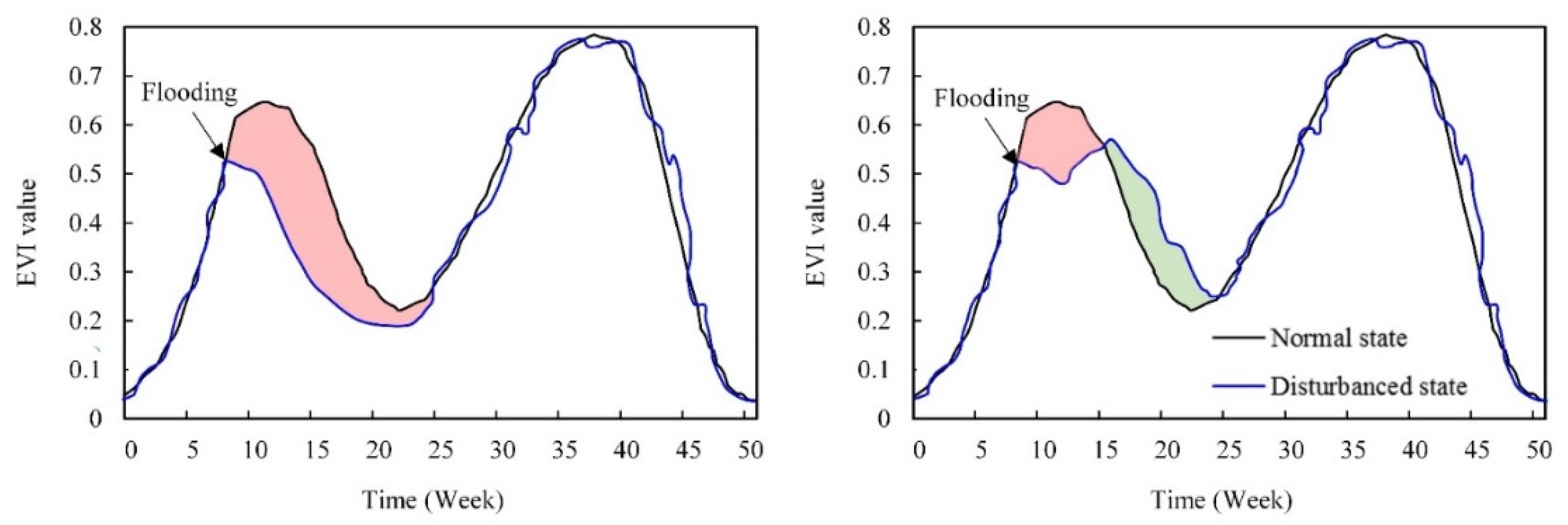
2.1. Conceptual Model for Monitoring Flood Impacts on Crop Growth
2.2. Coupled Hydrological and 2D Hydraulic Model for Flooding Simulation
2.3. Random Forest Model for Identifying Flood Impact on Crop Production
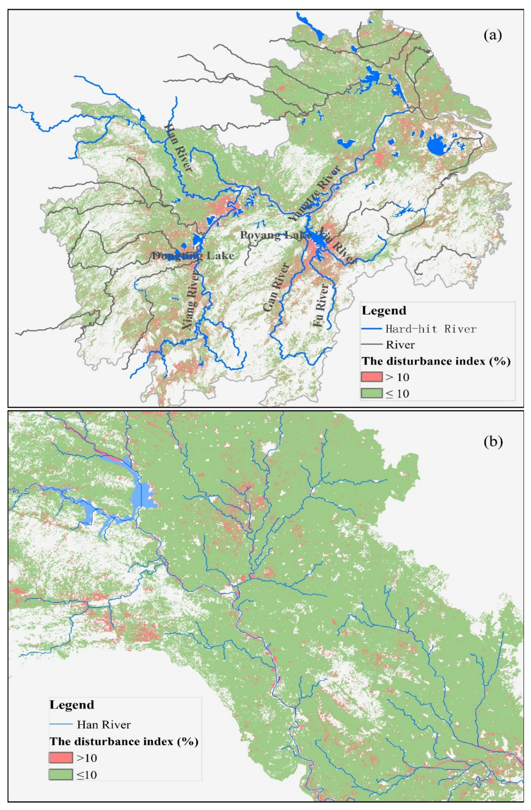
2.4. The Study Area and Events
2.5. Data Acquisition
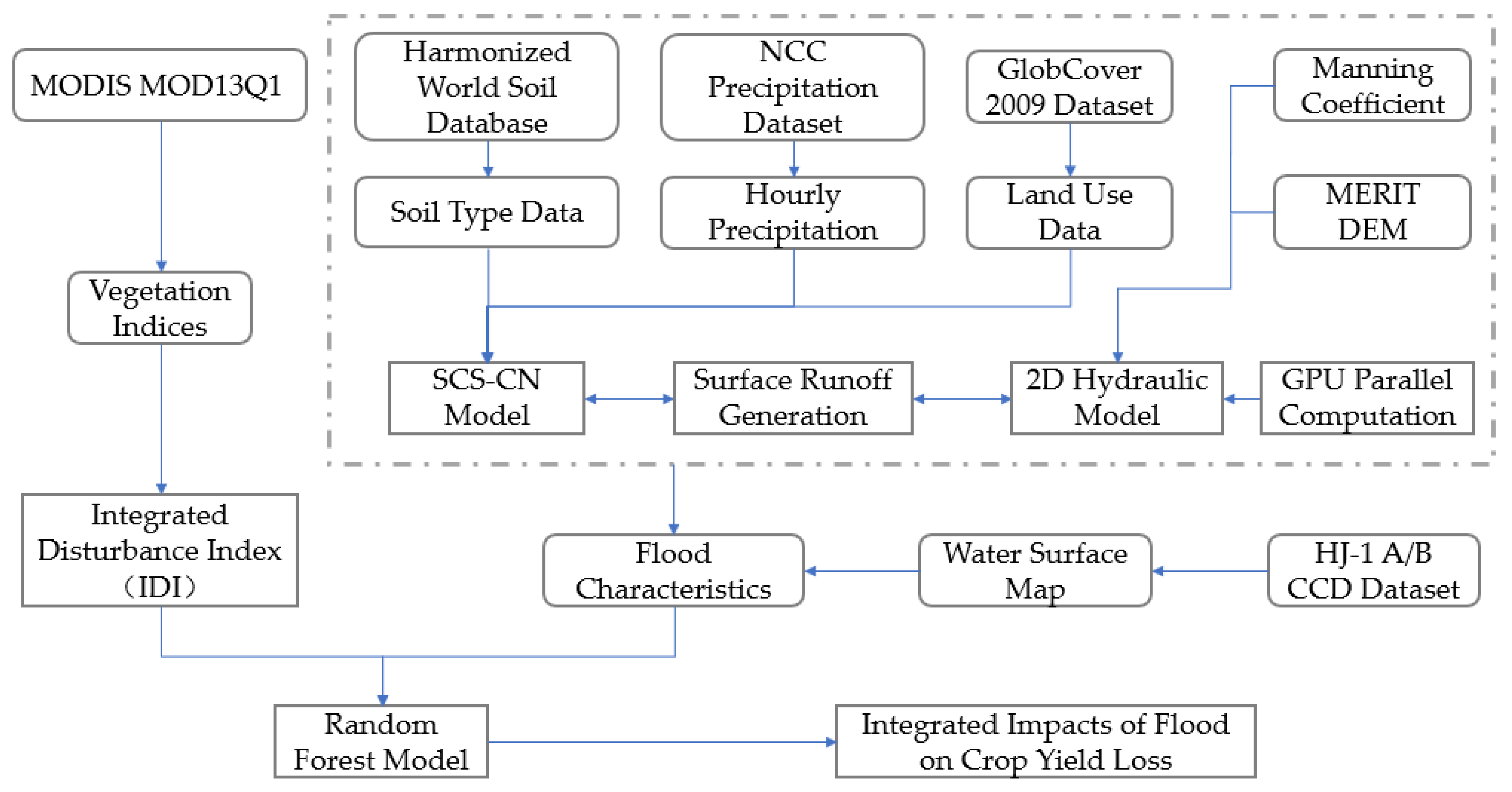
2.6. Study Framework
- (1)
- The calculation of integrated disturbance index (IDI). The integrated disturbance index (IDI) was applied to the MODIS EVI dataset for 17 years.
- (2)
- Flood Simulation. The spatial surface characteristics and precipitation were input into the coupled SCS-CN and 2D hydraulic model, and the flood process was simulated for MLYRB with GPU parallel computing.
- (3)
- The integrated impacts of flood on crop yield loss. Random forest was adopted to predict the crop damage extent with different flood characteristics.
3. Results
3.1. The Characteristics of Flood Disturbances on Crop Yields
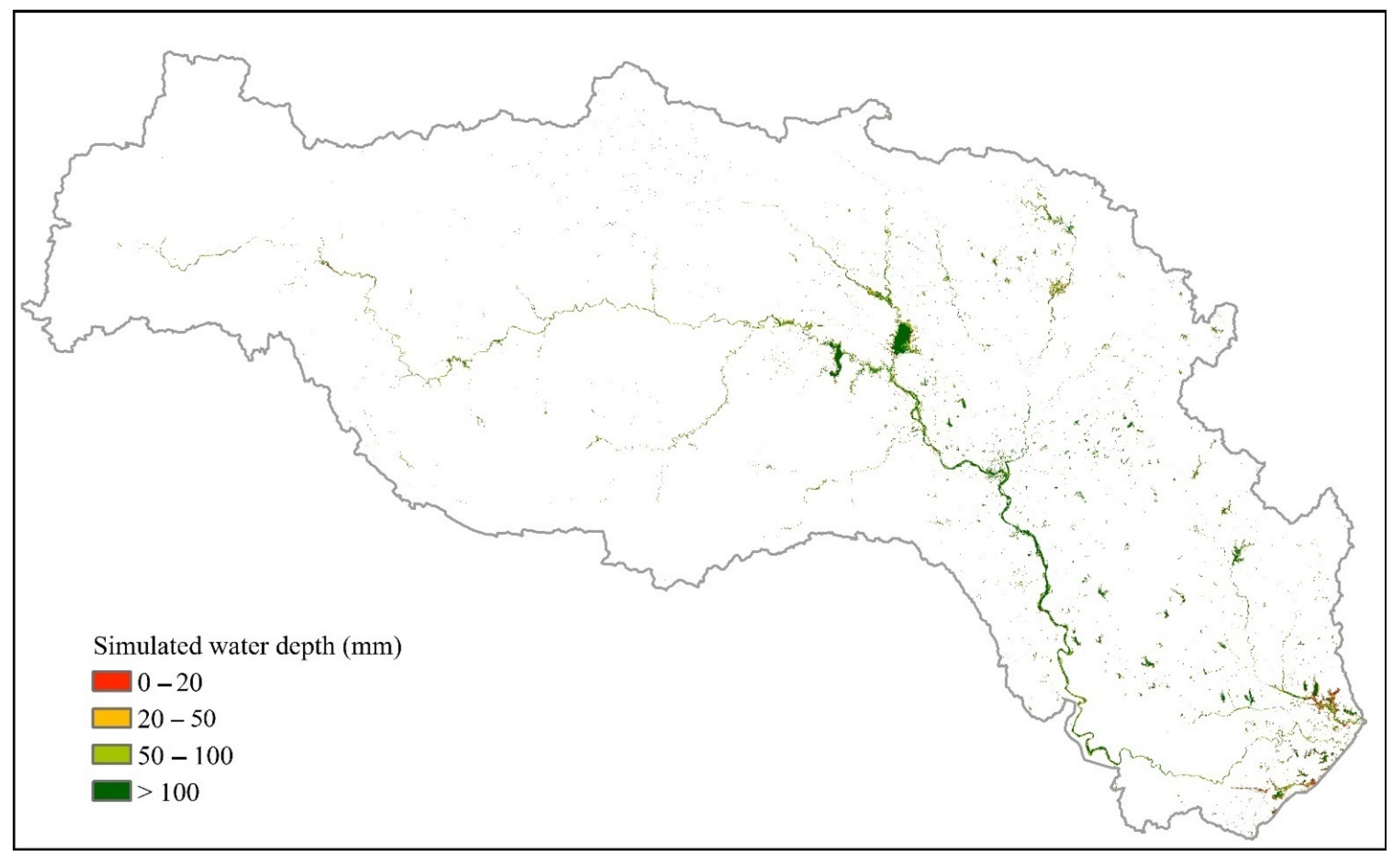
3.2. Flood Simulation Results
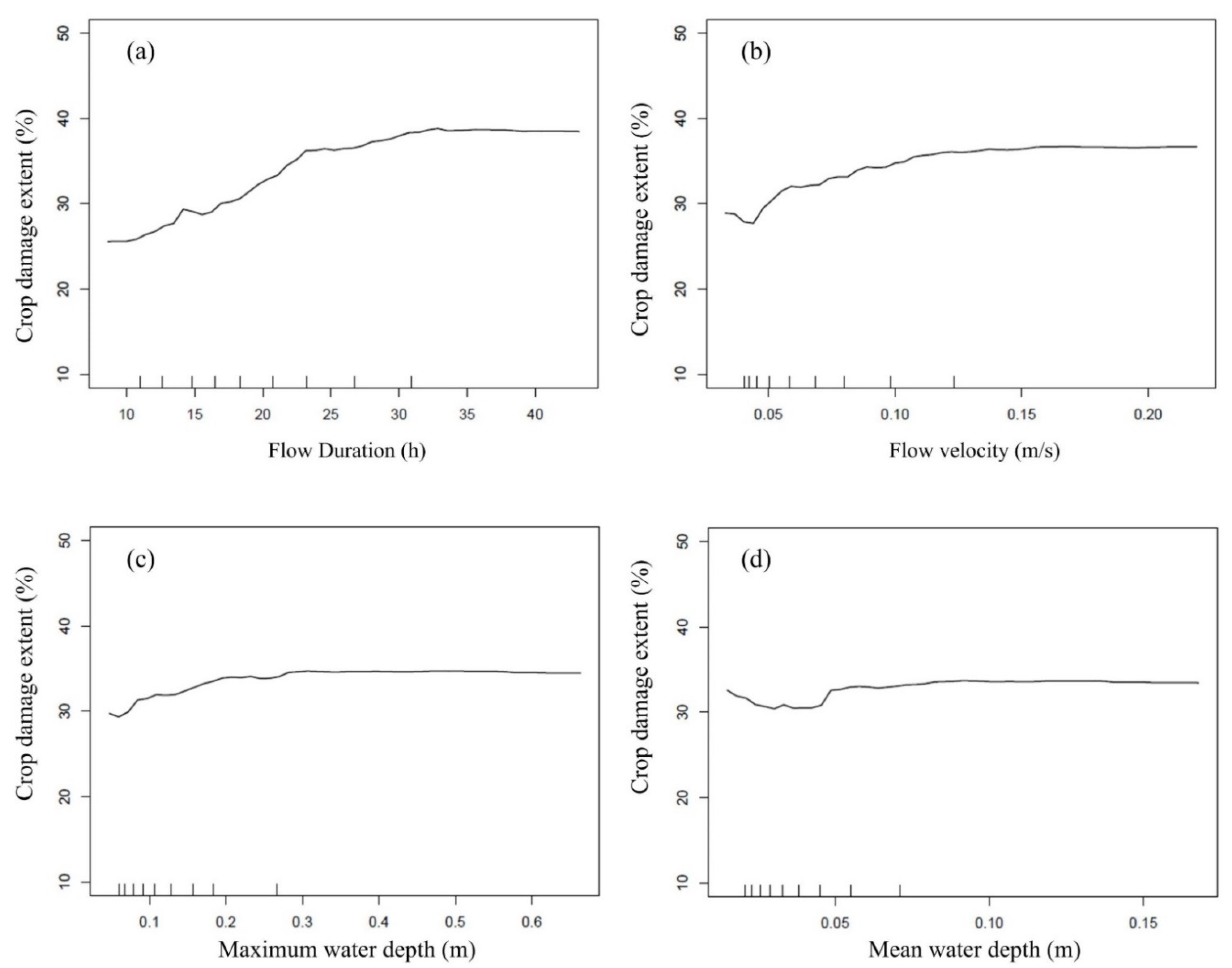
3.3. The Relationship between Flood Characteristic and Crop Damage Extent
4. Discussion
5. Conclusions
Author Contributions
Funding
Institutional Review Board Statement
Conflicts of Interest
References
- Schmidhuber, J.; Tubiello, F.N. Global food security under climate change. Proc. Natl. Acad. Sci. USA 2007, 104, 19703–19708. [Google Scholar] [CrossRef] [Green Version]
- Vervuren, P.; Blom, C.W.P.M.; De-Kroon, H. Extreme flooding events on the Rhine and the survival and distribution of riparian plant species. J. Ecol. 2003, 91, 135–146. [Google Scholar] [CrossRef]
- Youssef, M.S.; Mira, M.M.; Renault, S.; Hill, R.D.; Stasolla, C. Phytoglobin expression influences soil flooding response of corn plants. Ann. Bot. 2016, 118, 919–931. [Google Scholar] [CrossRef] [Green Version]
- Sun, L.; Chen, S.; Chao, L.; Sun, T. Effects of flooding on changes in Eh, pH and speciation of cadmium and lead in contaminated soil. Bull. Environ. Contam. Toxicol. 2007, 79, 514–518. [Google Scholar] [CrossRef]
- Urban, D.W.; Roberts, M.J.; Schlenker, W.; Lobell, D.B. The effects of extremely wet planting conditions on maize and soybean yields. Clim. Change 2015, 130, 247–260. [Google Scholar] [CrossRef]
- Christopher, B.F.; Vicente, B.; Thomas, F.S.; Qin, D. Managing the Risks of Extreme Events and Disasters to Advance Climate Change Adaptation; Cambridge University Press: Cambridge, UK, 2012; pp. 109–230. [Google Scholar]
- Blöschl, G.; Hall, J.; Parajka, J.; Perdigão, R.A.P.; Merz, B.; Arheimer, B.; Aronica, G.T.; Bilibashi, A.; Bonacci, O.; Borga, M.; et al. Changing climate shifts timing of European floods. Science 2017, 357, 588–590. [Google Scholar] [CrossRef] [Green Version]
- Jiabo, Y.; Shenglian, G.; Pierre, G.; Sylvia, C. Does the Hook Structure Constrain Future Flood Intensification Under Anthropogenic Climate Warming? Water Resour. Res. 2021, 57, 2020. [Google Scholar]
- Liu, J.; Shi, Z.W. Quantifying land-use change impacts on the dynamic evolution of flood vulnerability. Land Use Policy 2017, 65, 198–210. [Google Scholar] [CrossRef]
- Liu, X.; Chen, L.; Zhu, Y.; Singh, V.P.; Qu, G.; Guo, X. Multi-objective reservoir operation during flood season considering spillway optimization. J. Hydrol. 2017, 552, 554–563. [Google Scholar] [CrossRef]
- Zhang, Q.; Xu, C.Y.; Zhang, Z.; Chen, Y.D.; Liu, C.L.; Lin, H. Spatial and temporal variability of precipitation maxima during 1960–2005 in the Yangtze River basin and possible association with large-scale circulation. J. Hydrol. 2008, 353, 215–227. [Google Scholar] [CrossRef]
- Yin, H.; Li, C. Human impact on floods and flood disasters on the Yangtze River. Geomorphology 2001, 41, 105–109. [Google Scholar] [CrossRef]
- Chen, Z.; Li, J.; Shen, H.; Wang, Z. Yangtze River of China: Historical analysis of discharge variability and sediment flux. Geomorphology 2001, 41, 77–91. [Google Scholar] [CrossRef]
- Yu, F.; Chen, Z.; Ren, X.; Yang, G. Analysis of historical floods on the Yangtze River, China: Characteristics and explanations. Geomorphology 2009, 113, 210–216. [Google Scholar] [CrossRef]
- Jiang, L.; An, P. Temporal and spatial distribution and grain risk assessment of natural disasters in China. J. Catastrophology 2011, 26, 48–53. (In Chinese) [Google Scholar]
- Su, B.; Xiao, B.; Zhu, D.; Jiang, T. Trends in frequency of precipitation extremes in the Yangtze River basin, China: 1960–2003. Hydrol. Sci. J. 2005, 50, 479–492. [Google Scholar]
- Zhang, Q.; Peng, J.; Xu, C.Y.; Singh, V.P. Spatiotemporal variations of precipitation regimes across Yangtze River Basin, China. Theor. Appl. Climatol. 2014, 115, 703–712. [Google Scholar] [CrossRef]
- Hu, M.; Dong, M.; Tian, X.; Wang, L.; Jiang, Y. Trends in Different Grades of Precipitation over the Yangtze River Basin from 1960 to 2017. Atmosphere 2021, 12, 413. [Google Scholar] [CrossRef]
- Li, X.; Zhang, K.; Gu, P.; Feng, H.; Yin, Y.; Chen, W.; Cheng, B. Changes in precipitation extremes in the Yangtze River Basin during 1960–2019 and the association with global warming, ENSO, and local effects. Sci. Total Environ. 2021, 760, 144244. [Google Scholar] [CrossRef]
- Su, B.; Kundzewicz, Z.W.; Tong, J. Simulation of extreme precipitation over the Yangtze River basin using Wakeby distribution. Theor. Appl. Climatol. 2009, 96, 209–219. [Google Scholar] [CrossRef]
- Wu, Y.; Wu, S.Y.; Wen, J.; Tagle, F.; Xu, M.; Tan, J. Future Changes in Mean and Extreme Monsoon Precipitation in the Middle and Lower Yangtze River Basin, China, in the CMIP5 Models. J. Hydrometeorol. 2016, 17, 2785–2797. [Google Scholar] [CrossRef]
- Zhang, Z.; Zhang, Q.; Xu, C.; Liu, C.; Jiang, T. Atmospheric moisture budget and floods in the Yangtze River basin, china. Theor. Appl. Climatol. 2009, 95, 331–340. [Google Scholar] [CrossRef]
- Yin, R.S.; Xiang, Q.; Xu, J.T.; Deng, X.Z.; Yin, R. Modeling the driving forces of the land use and land cover changes along the upper Yangtze River of China. Environ. Manag. 2010, 45, 454–465. [Google Scholar] [CrossRef]
- Cong, X.; Xin, H.; Mu, H.; Wei, Y. Impacts of land-use changes on the lakes across the Yangtze floodplain in china. Environ. Sci. Technol. 2017, 51, 3669. [Google Scholar]
- Nakayama, T.; Watanabe, M. Role of flood storage ability of lakes in the Changjiang River catchment. Glob. Planet. Change 2008, 63, 9–22. [Google Scholar] [CrossRef]
- Du, Y.; Xue, H.P.; Wu, S.J.; Ling, F.; Xiao, F.; Wei, X.H. Lake area changes in the middle Yangtze region of China over the 20th century. J. Environ. Manag. 2011, 92, 1248–1255. [Google Scholar] [CrossRef]
- Zhang, Q.; Liu, C.; Xu, C.Y.; Xu, Y.; Jiang, T. Observed trends of annual maximum water level and streamflow during past 130 years in the Yangtze River basin, china. J. Hydrol. 2006, 324, 255–265. [Google Scholar] [CrossRef]
- Nakayama, T.; Shankman, D. Impact of the Three-Gorges Dam and water transfer project on Changjiang floods. Glob. Planet. Change 2013, 100, 38–50. [Google Scholar] [CrossRef]
- Meng, L.; Wang, C.; Zhang, J. Heat injury risk assessment for single-cropping rice in the middle and lower reaches of the Yangtze River under climate change. J. Meteorol. Res. 2016, 30, 426–443. [Google Scholar] [CrossRef]
- Lesk, C.; Rowhani, P.; Ramankutty, N. Influence of extreme weather disasters on global crop production. Nature 2016, 529, 84–87. [Google Scholar] [CrossRef]
- Lee, K.S.; Lee, S.I. Assessment of post-flooding conditions of rice fields with multi-temporal satellite SAR data. Int. J. Remote Sens. 2003, 24, 3457–3465. [Google Scholar] [CrossRef]
- Pantaleoni, E.; Engel, B.A.; Johannsen, C.J. Identifying agricultural flood damage using Landsat imagery. Precis. Agric. 2007, 8, 27–36. [Google Scholar] [CrossRef]
- Džubáková, K.; Molnar, P.; Schindler, K.; Trizna, M. Monitoring of riparian vegetation response to flood disturbances using terrestrial photography. Hydrol. Earth Syst. Sci. 2015, 19, 195–208. [Google Scholar] [CrossRef] [Green Version]
- Shrestha, R.; Di, L.; Eugene, G.Y.; Kang, L.; Shao, Y.Z.; Bai, Y.Q. Regression model to estimate flood impact on corn yield using MODIS NDVI and USDA cropland data layer. J. Integr. Agric. 2017, 16, 398–407. [Google Scholar] [CrossRef] [Green Version]
- Chen, H.; Liang, Z.; Liu, Y.; Liang, Q.; Xie, S. Integrated remote sensing imagery and two-dimensional hydraulic modeling approach for impact evaluation of flood on crop yields. J. Hydrol. 2017, 553, 262–275. [Google Scholar] [CrossRef] [Green Version]
- Zhang, X.; Friedl, M.A.; Schaaf, C.B.; Strahler, A.H.; Hodges, J.C.F.; Gao, F.; Reed, B.C.; Huete, A. Monitoring vegetation phenology using MODIS. Remote Sens. Environ. 2003, 84, 471–475. [Google Scholar] [CrossRef]
- Sakamoto, T.; Yokozawa, M.; Toritani, H.; Shibayama, M.; Ishitsuka, N.; Ohno, H. A crop phenology detection method using time-series MODIS data. Remote Sens. Environ. 2005, 96, 366–374. [Google Scholar] [CrossRef]
- Chen, H.; Liang, Q.; Liang, Z.; Liu, Y.; Xie, S. Remote-sensing disturbance detection index to identify spatio-temporal varying flood impact on crop production. Agric. For. Meteorol. 2019, 269, 180–191. [Google Scholar] [CrossRef]
- Samuels, P.; Klijn, F.; Dijkman, J. An analysis of the current practice of policies on river flood risk management in different countries. Irrig. Drain. 2006, 55, S141–S150. [Google Scholar] [CrossRef]
- Dinh, Q.; Balica, S.; Popescu, I.; Jonoski, A. Climate change impact on flood hazard, vulnerability and risk of the Long Xuyen Quadrangle in the Mekong Delta. Int. J. River Basin Manag. 2012, 10, 103–120. [Google Scholar] [CrossRef]
- Marti, J.; Savin, R.; Slafer, G.A. Wheat yield as affected by length of exposure to waterlogging during stem elongation. J. Agron. Crop Sci. 2015, 201, 473–486. [Google Scholar] [CrossRef]
- Kaur, G.; Zurweller, B.A.; Nelson, K.A.; Motavalli, P.P.; Dudenhoeffer, C.J. Soil waterlogging and nitrogen fertilizer management effects on corn and soybean yields. Agron. J. 2017, 109, 97–106. [Google Scholar] [CrossRef]
- Ploschuk, R.A.; Daniel, J.M.; Timothy, D.C.; Striker, G.G. Waterlogging differentially affects yield and its components in wheat, barley, rapeseed and field pea depending on the timing of occurrence. J. Agron. Crop Sci. 2020, 206, 363–375. [Google Scholar] [CrossRef]
- Meng, Y.; Yu, S.; Yu, Y.; Jiang, L. Flooding depth and duration concomitantly influence the growth traits and yield of rice. Irrig. Drain. 2021, 9, 94–107. [Google Scholar] [CrossRef]
- Yang, J.; Huo, Z.; Wu, L.; Wang, T.; Zhang, G. Indicator-based evaluation of spatiotemporal characteristics of rice flood in southwest china. Agric. Ecosyst. Environ. 2016, 230, 221–230. [Google Scholar] [CrossRef]
- Li, S.; Tompkins, A.M.; Lin, E.; Ju, H. Simulating the impact of flooding on wheat yield–Case study in East China. Agric. For. Meteorol. 2016, 216, 221–231. [Google Scholar] [CrossRef]
- Chipanshi, A.; Zhang, Y.; Kouadio, L.; Newlands, N.; Davidson, A.; Hill, H.; Warren, R.; Qian, B.; Daneshfar, B.; Bedard, F.; et al. Evaluation of the integrated Canadian crop yield forecaster (ICCYF) model for in-season prediction of crop yield across the Canadian agricultural landscape. Agric. For. Meteorol. 2015, 206, 137–150. [Google Scholar] [CrossRef] [Green Version]
- Biancamaria, S.; Bates, P.D.; Boone, A.; Mognard, N.M. Large-scale coupled hydrologic and hydraulic modelling of the Ob river in Siberia. J. Hydrol. 2009, 379, 136–150. [Google Scholar] [CrossRef] [Green Version]
- Caviedes-Voullième, D.; García-Navarro, P.; Murillo, J. Influence of mesh structure on 2D full shallow water equations and SCS Curve Number simulation of rainfall/runoff events. J. Hydrol. 2012, 448–449, 39–59. [Google Scholar] [CrossRef]
- Cea, M.; Rodriguez, M. Two-dimensional coupled distributed hydrologic–hydraulic model simulation on watershed. Pure Appl. Geophys. 2016, 173, 909–922. [Google Scholar] [CrossRef]
- Fernández-Pato, J.; Caviedes-Voullième, D.; García-Navarro, P. Rainfall/runoff simulation with 2d full shallow water equations: Sensitivity analysis and calibration of infiltration parameters. J. Hydrol. 2016, 536, 496–513. [Google Scholar] [CrossRef]
- Liu, Z.; Merwade, V.; Jafarzadegan, K. Investigating the role of model structure and surface roughness in generating flood inundation extents using one-and two-dimensional hydraulic models. J. Flood Risk Manag. 2019, 12, e12347. [Google Scholar] [CrossRef] [Green Version]
- Shen, D.; Qian, T.; Xia, Y.; Zhang, Y.; Wang, J. Micro-scale Flood Hazard Assessment Based on Catastrophe Theory and an Integrated 2-D Hydraulic Model: A Case Study of Gongshuangcha Detention Basin in Dongting Lake Area, China. ISPRS Int. J. Geo-Inf. 2020, 9, 206. [Google Scholar] [CrossRef] [Green Version]
- Yamazaki, D.; Kanae, S.; Kim, H.; Oki, T. A physically based description of floodplain inundation dynamics in a global river routing model. Water Resour. Res. 2011, 47, W04501. [Google Scholar] [CrossRef]
- Schumann, J.P.; Neal, J.C.; Voisin, N.; Andreadis, K.M.; Pappenberger, F.; Phanthuwongpakdee, N.; Hall, A.C.; Bates, P.D. A first large-scale flood inundation forecasting model. Water Resour. Res. 2013, 49, 6248–6257. [Google Scholar] [CrossRef]
- Kalyanapu, A.J.; Shankar, S.; Pardyjak, E.R.; Judi, D.R.; Burian, S.J. Assessment of GPU computational enhancement to a 2D flood model. Environ. Model. Softw. 2011, 26, 1009–1016. [Google Scholar] [CrossRef]
- Vacondio, R.; Dal Palù, A.; Ferrari, A.; Mignosa, P.; Aureli, F.; Dazzi, S. A non-uniform efficient grid type for GPU-parallel Shallow Water Equations models. Environ. Model. Softw. 2017, 88, 119–137. [Google Scholar] [CrossRef]
- Wu, Q.; Chen, Y.; Wilson, J.; Liu, X.; Li, H. An effective parallelization algorithm for DEM generalization based on CUDA. Environ. Model. Softw. 2019, 114, 64–74. [Google Scholar] [CrossRef]
- Morales-Hernández, M.; Sharif, B.; Alfred, J.K.; Sheikh, K.G.; Tigstu, T.D.; Gangrade, S.; Kao, S.; Matthew, R.N.; Katherine, J.E. TRITON: A Multi-GPU open source 2D hydrodynamic flood model. Environ. Model. Softw. 2021, 141, 105034. [Google Scholar] [CrossRef]
- Carlotto, T.; Chaffe, P.L.B.; Santos, C.I.D.; Lee, S. SW2D-GPU: A two-dimensional shallow water model accelerated by GPGPU. Environ. Model. Softw. 2021, 145, 105205. [Google Scholar] [CrossRef]
- Armstrong, W. Aeration in higher plants. Adv. Bot. Res. 1980, 7, 225–332. [Google Scholar]
- Collaku, A.; Harrison, S.A. Losses in wheat due to waterlogging. Crop Sci. 2002, 42, 444–450. [Google Scholar] [CrossRef]
- Kaur, G.; Zurweller, B.; Motavalli, P.P.; Nelson, K.A. Screening Corn Hybrids for Soil Waterlogging Tolerance at an Early Growth Stage. Agriculture 2019, 9, 33. [Google Scholar] [CrossRef] [Green Version]
- Gautam, P.; Lal, B.; Raja, R.; Tripathi, R.; Shahid, M.; Baig, M.J.; Puree, C.; Mohanty, S.; Nayak, A.K. Effect of simulated flash flooding on rice and its recovery after flooding with nutrient management strategies. Ecol. Eng. 2015, 77, 250–256. [Google Scholar] [CrossRef]
- Ding, J.; Liang, P.; Guo, D.; Liu, D.; Yin, M.; Zhu, M.; Li, C.; Zhu, X.; Guo, W. Remedial Application of Urea Eliminates Yield Losses in Wheat Waterlogged during Stem Elongation. Agriculture 2020, 10, 23. [Google Scholar] [CrossRef] [Green Version]
- Ciancio, N.; Daniel, J.M.; Striker, G.G.; Abeledo, L.G. Plant growth rate after, and not during, waterlogging better correlates to yield responses in wheat and barley. J. Agron. Crop Sci. 2021, 207, 304–316. [Google Scholar] [CrossRef]
- Zhang, X.; Zhang, Q. Monitoring interannual variation in global crop yield using long-term AVHRR and MODIS observations. ISPRS J. Photogramm. Remote Sens. 2016, 114, 191–205. [Google Scholar] [CrossRef]
- Rahman, M.S.; Di, L. A Systematic Review on Case Studies of Remote-Sensing-Based Flood Crop Loss Assessment. Agriculture 2020, 10, 131. [Google Scholar] [CrossRef] [Green Version]
- Benedetti, R.; Rossini, P. On the use of NDVI profiles as a tool for agricultural statistics: The case study of wheat yield estimate and forecast in Emilia Romagna. Remote Sens. Environ. 1993, 45, 311–326. [Google Scholar] [CrossRef]
- Funk, C.; Budde, M.E. Phenologically-tuned MODIS NDVI-based production anomaly estimates for Zimbabwe. Remote Sens. Environ. 2009, 113, 115–125. [Google Scholar] [CrossRef]
- Esquerdo, J.C.D.M.; Zullo Júnior, J.; Antunes, J.F.G. Use of NDVI/AVHRR time-series profiles for soybean crop monitoring in Brazil. Int. J. Remote Sens. 2011, 32, 3711–3727. [Google Scholar] [CrossRef]
- Son, N.T.; Chen, C.F.; Chen, C.R.; Minh, V.Q.; Trung, N.H. A comparative analysis of multitemporal MODIS EVI and NDVI data for large-scale rice yield estimation. Agric. For. Meteorol. 2014, 197, 52–64. [Google Scholar] [CrossRef]
- Bernardes, T.; Moreira, M.A.; Adami, M.; Giarolla, A. Monitoring biennial bearing effect on coffee yield using MODIS remote sensing imagery. Remote Sens. 2012, 4, 3760–3763. [Google Scholar] [CrossRef] [Green Version]
- Zhang, J.; Feng, L.; Yao, F. Improved maize cultivated area estimation over a large scale combining MODIS–EVI time series data and crop phenological information. ISPRS J. Photogramm. Remote Sens. 2014, 94, 102–113. [Google Scholar] [CrossRef]
- Huete, A.; Didan, K.; Miura, T.; Rodriguez, E.P.; Gao, X.; Ferreira, L.G. Overview of the radiometric and biophysical performance of the MODIS vegetation indices. Remote Sens. Environ. 2002, 83, 195–213. [Google Scholar] [CrossRef]
- Rocha, A.V.; Shaver, G.R. Advantages of a two band EVI calculated from solar and photosynthetically active radiation fluxes. Agric. For. Meteorol. 2009, 149, 1560–1563. [Google Scholar] [CrossRef]
- Mildrexler, D.J.; Zhao, M.; Running, S.W. Testing a MODIS global disturbance index across North America. Remote Sens. Environ. 2009, 113, 2103–2117. [Google Scholar] [CrossRef]
- Woodward, D.; Hawkings, R.; Hjelmfelt, A.; Van Mullen, J.; Quan, Q. Curve Number Method: Origins, Applications and Limitations. In Proceedings of the US Geological Survey Advisory Committee on Water Information—Second Federal Interagency Hydrologic Modeling Conference, Las Vegas, NV, USA, 28 July–1 August 2002. [Google Scholar]
- Bartlett, M.S.; Parolari, A.J.; McDonnell, J.J.; Porporato, A. Beyond the SCS-CN method: A theoretical framework for spatially lumped rainfall-runoff response. Water Resour. Res. 2016, 52, 4608–4627. [Google Scholar] [CrossRef] [Green Version]
- Mishra, S.K.; Singh, V.P. Soil Conservation Service Curve Number (SCS-CN) Methodology (Volume 42), 1st ed.; Kluwer Academic Publisher: New York, NY, USA, 2003; pp. 88–108. [Google Scholar]
- Liang, Q.; Marche, F. Numerical resolution of well-balanced shallow water equations with complex source terms. Adv. Water Resour. 2009, 32, 873–884. [Google Scholar] [CrossRef]
- Song, L.; Zhou, J.; Guo, J.; Zou, Q.; Liu, Y. A robust well-balanced finite volume model for shallow water flows with wetting and drying over irregular terrain. Adv. Water Resour. 2011, 34, 915–932. [Google Scholar] [CrossRef]
- Hou, J.; Liang, Q.; Zhang, H.; Hinkelmann, R. An efficient unstructured MUSCL scheme for solving the 2D shallow water equations. Environ. Model. Softw. 2015, 66, 131–152. [Google Scholar] [CrossRef] [Green Version]
- Xia, X.; Liang, Q.; Ming, X.; Hou, J. An efficient and stable hydrodynamic model with novel source term discretization schemes for overland flow and flood simulations. Water Resour. Res. 2017, 53, 3730–3759. [Google Scholar] [CrossRef]
- Su, B.; Huang, H.; Zhu, W. An urban pluvial flood simulation model based on diffusive wave approximation of shallow water equations. Hydrol. Res. 2019, 50, 138–154. [Google Scholar] [CrossRef]
- Pilar, G.; Javier, M.; Fernández-Pato, J.; Isabel, E.; Mario, M. The shallow water equations and their application to realistic cases. Environ. Fluid Mech. 2019, 19, 1235–1252. [Google Scholar]
- Vreugdenhil, C.B. Numerical Methods for Shallow-Water Flow (Volume 13), 1st ed.; Kluwer Academic Publisher: New York, NY, USA, 1994; pp. 15–41. [Google Scholar]
- Dehghan, M.; Abbaszadeh, M.; Dehghan, M.; Abbaszadeh, M. The use of proper orthogonal decomposition (POD) meshless RBF-FD technique to simulate the shallow water equations. J. Comput. Phys. 2017, 351, 478–510. [Google Scholar] [CrossRef]
- Francesca, A.; Federico, P.; Vacondio, R.; Susanna, D.; Alessia, F. A GPU-Accelerated Shallow-Water Scheme for Surface Runoff Simulations. Water 2020, 12, 637. [Google Scholar]
- NVIDIA CUDA. NVIDIA CUDA C++ Programming Guide v11.4. 2021. Available online: https://docs.nvidia.com/cuda/pdf/CUDA_C_Programming_Guide.pdf (accessed on 24 January 2022).
- Schumann, G.J.P.; Bates, P.D.; Neal, J.C.; Andreadis, K.M. Technology: Fight floods on a global scale. Nature 2014, 507, 169. [Google Scholar] [CrossRef]
- Yamazaki, D.; Ikeshima, D.; Tawatari, R.; Yamaguchi, T.; O’Loughlin, F.; Neal, J.C. A high-accuracy map of global terrain elevations. Geophys. Res. Lett. 2017, 44, 5844–5853. [Google Scholar] [CrossRef] [Green Version]
- Chen, H.L.; Liang, Q.H.; Liu, Y.; Xie, S. Hydraulic correction method (HCM) to enhance the efficiency of SRTM DEM in flood modeling. J. Hydrol. 2018, 559, 56–70. [Google Scholar] [CrossRef] [Green Version]
- Song, S.; He, R.; Shi, Z.; Zhang, W. Variable Importance Measure System Based on Advanced Random Forest. CMES-Comput. Modeling Eng. Sci. 2021, 128, 65–85. [Google Scholar] [CrossRef]
- Breiman, L. Random forests. Mach. Learn. 2001, 45, 5–32. [Google Scholar] [CrossRef] [Green Version]
- Welling, S.H.; Refsgaard, H.H.F.; Brockhoff, P.B.; Clemmensen, L.H. Forest Floor Visualizations of Random Forests. 2016. Available online: https://arxiv.org/abs/1605.09196 (accessed on 4 July 2016).
- Liaw, A.; Wiener, M. Classification and Regression by random Forest. R News 2002, 2, 18–22. [Google Scholar]
- R Core Team. A Language and Environment for Statistical Computing; R Foundation for Statistical Computing: Vienna, Austria, 2015; Available online: http://www.R-project.org/ (accessed on 24 January 2022).
- Ding, Y.; Wang, W.; Song, R.; Shao, Q.; Jiao, X.; Xing, W. Modeling spatial and temporal variability of the impact of climate change on rice irrigation water requirements in the middle and lower reaches of the Yangtze River, China. Agric. Water Manag. 2017, 193, 89–101. [Google Scholar] [CrossRef]
- Sun, Z.; Zhu, X.; Pan, Y.; Zhang, J. Assessing Terrestrial Water Storage and Flood Potential Using GRACE Data in the Yangtze River Basin, China. Remote Sens. 2017, 9, 1011. [Google Scholar] [CrossRef] [Green Version]
- Chinese Office of State Flood Control and Drought Relief Headquarters. Flood disaster of China in 2010. China Flood Drought Manag. 2011, 21, 1–3. [Google Scholar]
- Li, S.; Zhang, Q. Geochemistry of the upper Han River basin, China: 2: Seasonal variations in major ion compositions and contribution of precipitation chemistry to the dissolved load. J. Hazard. Mater. 2009, 170, 605–611. [Google Scholar] [CrossRef]
- Liu, W.; Liu, G.; Zhang, Q. Influence of vegetation characteristics on soil denitrification in shoreline wetlands of the Danjiangkou Reservoir in China. Clean-Soil Air Water 2011, 39, 109–115. [Google Scholar] [CrossRef]
- Huete, A.; Didan, K.; Leeuwen, W.V.; Miura, T.; Glenn, E. MODIS Vegetation Indices. In Land Remote Sensing and Global Environmental Change; Ramachandran, B., Christopher, O.J., Michael, J.A., Eds.; Springer: New York, NY, USA; Dordrecht, The Netherlands; Heidelberg, Germany; London, UK, 2011; Volume 11, pp. 579–602. [Google Scholar]
- Ticehurst, C.; Guerschman, J.P.; Chen, Y. The strengths and limitations in using the daily MODIS open water likelihood algorithm for identifying flood events. Remote Sens. 2014, 6, 11791–11809. [Google Scholar] [CrossRef] [Green Version]
- Huete, A.; Justice, C.O.; Van Leeuwen, W. MODIS Vegetation Index (MOD13): Algorithm Theoretical Basis Document. 2011. Available online: http://modis.gsfc.nasa.gov/data/atbd/atbd_mod13.pdf (accessed on 8 February 2011).
- Arino, O.; Perez, J.J.R.; Kalogirou, V.; Bontemps, S.; Defourny, P.; Van Bogaert, E. Global Land Cover Map for 2009 (GlobCover 2009). European Space Agency (ESA) & Université Catholique de Louvain (UCL), PANGAEA. 2012. Available online: https://doi.org/10.1594/PANGAEA.787668 (accessed on 24 January 2022). [CrossRef]
- Nachtergaele, F.O.; Velthuizen, V.L.; Batjes, N.H.; Dijkshoorn, J.A.; van Engelen, V.W.P.; Fischer, G.; Jones, A.; Montanarella, L.; Petri, M.; Prieler, S.; et al. Harmonized World Soil Database (Version 1.2). 2012. Available online: https://research.wur.nl/en/publications/harmonized-world-soil-database-version-12 (accessed on 24 January 2022).
- Lehner, B.; Verdin, K.; Jarvis, A. New global hydrography derived from spaceborne elevation data. Eos Trans. Am. Geophys. Union 2008, 89, 93–94. [Google Scholar] [CrossRef]
- Zhang, Q.; Gu, X.; Singh, V.P.; Liu, L.; Kong, D. Flood-induced agricultural loss across China and impacts from climate indices. Glob. Planet. Change 2016, 139, 31–43. [Google Scholar] [CrossRef] [Green Version]
- Tehrany, M.S.; Pradhan, B.; Mansor, S.; Ahmad, N. Flood susceptibility assessment using GIS-based support vector machine model with different kernel types. Catena 2015, 125, 91–101. [Google Scholar] [CrossRef]
- Kazakis, N.; Kougias, I.; Patsialis, T. Assessment of flood hazard areas at a regional scale using an index-based approach and Analytical Hierarchy Process: Application in Rhodope–Evros region, Greece. Sci. Total Environ. 2015, 538, 555–563. [Google Scholar] [CrossRef] [PubMed]
- Samela, C.; Troy, T.J.; Manfreda, S. Geomorphic classifiers for flood-prone areas delineation for data-scarce environments. Adv. Water Resour. 2017, 102, 13–28. [Google Scholar] [CrossRef]
- Tang, Z.; Yi, S.; Wang, C.; Xiao, Y. Incorporating probabilistic approach into local multi-criteria decision analysis for flood susceptibility assessment. Stoch. Environ. Res. Risk Assess. 2018, 32, 701–714. [Google Scholar] [CrossRef]
- Chau, V.N.; Cassells, S.; Holland, J. Economic impact upon agricultural production from extreme flood events in Quang Nam, central Vietnam. Nat. Hazards 2015, 75, 1747–1765. [Google Scholar] [CrossRef]
- Dao, P.; Liou, Y. Object-based flood mapping and affected rice field estimation with Landsat 8 OLI and MODIS data. Remote Sens. 2015, 7, 5077–5097. [Google Scholar] [CrossRef] [Green Version]
- Sande, C.J.V.D.; Jong, S.M.D.; Roo, A.P.J.D. A segmentation and classification approach of ikonos-2 imagery for land cover mapping to assist flood risk and flood damage assessment. Int. J. Appl. Earth Obs. Geoinf. 2003, 4, 217–229. [Google Scholar] [CrossRef]
- Jonkman, S.N.; Bočkarjova, M.; Kok, M.; Bernardini, P. Integrated hydrodynamic and economic modelling of flood damage in the Netherlands. Ecol. Econ. 2008, 66, 77–90. [Google Scholar] [CrossRef]
- Vozinaki, A.E.K.; Kourgialas, N.N.; Karatzas, G.P. Estimation of agricultural flood loss in the Koiliaris river basin in Crete, Greece. Eur. Water. 2012, 39, 53–63. [Google Scholar]
- Vozinaki, A.E.K.; Karatzas, G.P.; Sibetheros, I.A.; Varouchakis, E.A. An agricultural flash flood loss estimation methodology: The case study of the Koiliaris basin (Greece), February 2003 flood. Nat. Hazards 2015, 79, 899–920. [Google Scholar] [CrossRef]
- Juan, P.; Luis, T. Performance assessment of two-dimensional hydraulic models for generation of flood inundation maps in mountain river basins. Water Sci. Eng. 2019, 12, 11–18. [Google Scholar]
- Jia, D.W.; Zhong, S.Q.; Li, X.; Peng, B. Extracting water information from the HSI data of HJ-1A/B satelite. Sci. Surv. Mapp. 2011, 36, 128–130. [Google Scholar]
- Wang, Q.Y.; Chen, R.X.; Xu, J.; Chen, X.L. Research on methods for extracting water body information from HJ-1A/B data. Sci. Technol. Eng. 2012, 12, 3051–3056. [Google Scholar]
- Liu, H.; Zheng, L.; Jiang, L.; Liao, M.W. Forty-year water body changes in Poyang Lake and the ecological impacts based on Landsat and HJ-1 A/B observations. J. Hydrol. 2020, 589, 125–161. [Google Scholar] [CrossRef]
- Mohammadi, A.; Costelloe, J.F.; Ryu, D. Application of time series of remotely sensed normalized difference water, vegetation and moisture indices in characterizing flood dynamics of large-scale arid zone floodplains. Remote Sens. Environ. 2017, 190, 70–82. [Google Scholar] [CrossRef]
- Singh, D.S.; Prajapati, S.K.; Singh, P.; Singh, K.; Kumar, D. Climatically induced levee break and flood risk management of the Gorakhpur region, Rapti River basin, Ganga Plain, India. J. Geol. Soc. India 2015, 85, 79–86. [Google Scholar] [CrossRef]
- Shrestha, B.B.; Kawasaki, A. Quantitative assessment of flood risk with evaluation of the effectiveness of dam operation for flood control: A case of the Bago River Basin of Myanmar. Int. J. Disaster Risk Reduct. 2020, 50, 101707. [Google Scholar] [CrossRef]
- Brémond, P.; Grelot, F.; Agenais, A.L. Review article: Economic evaluation of flood damage to agriculture—Review and analysis of existing methods. Nat. Hazards Earth Syst. Sci. 2013, 13, 2493–2512. [Google Scholar] [CrossRef]
- Vempi, S.A.H.; Daisuke, K. Developing flood vulnerability curve for rice crop using remote sensing and hydrodynamic modeling. Int. J. Disaster Risk Reduct. 2021, 54, 102058. [Google Scholar]
- Yin, H.; Liu, G.; Pi, J.; Chen, G.; Li, C. On the river–lake relationship of the middle Yangtze reaches. Geomorphology 2007, 85, 197–207. [Google Scholar] [CrossRef]
- Li, X.T.; Yu, C.Z.; Peng, L.C.; Zhang, F.F.; Li, J.; Yan, F.; Dong, Y.; Feng, B.L. How Does the Waterlogging Regime Affect Crop Yield? A Global Meta-Analysis. Front. Plant Sci. 2021, 12, 634898–634907. [Google Scholar]
- McDonald, G.T. Agricultural flood damage assessment: A review and investigation of a simulation method. Rev. Mark. Agric. Econ. 1970, 38, 105–120. [Google Scholar]
- Lacewell, R.D.; Eidman, V.R. A General Model for Evaluating Agricultural Flood Plains. Am. J. Agric. Econ. 1972, 54, 92–101. [Google Scholar] [CrossRef]
- Hoes, O.; Schuurmans, W. Flood standards or risk analyses for polder management in the Netherlands. Irrig. Drain. 2006, 55, 113–119. [Google Scholar] [CrossRef]
- Lacewell, R.D.; Freeman, R.; Petit, D.; Rister, E.; Sturdivant, A.; Ribera, L.; Zinn, M. Update of Estimated Agricultural Benefits Attributable to Drainage and Flood Control in Willacy County, Texas. Texas Water Resources Institute. 2006. Available online: https://hdl.handle.net/1969.1/6084 (accessed on 24 January 2022).
- Dutta, D.; Herath, S.; Musiake, K. A mathematical model for flood loss estimation. J. Hydrol. 2003, 277, 24–49. [Google Scholar] [CrossRef]
- Förster, S.; Kuhlmann, B.; Lindenschmidt, K.E.; Bronstert, A.L. Assessing flood risk for a rural detention area. Nat. Hazards Earth Syst. Sci. 2008, 8, 311–322. [Google Scholar] [CrossRef]
- Kwak, Y.; Shrestha, B.B.; Yorozuya, A.; Sawano, H. Rapid damage assessment of rice crop after large-scale flood in the Cambodian floodplain using temporal spatial data. IEEE J. Sel. Top. Appl. Earth Obs. Remote Sens. 2017, 8, 3700–3709. [Google Scholar] [CrossRef]
- Vega-Serratos, B.E.; Domínguez-Mor, R.; Posada-Vanegas, G. Seasonal flood risk assessment in agricultural areas. Tecnol. Cienc. Agua. 2018, 9, 92–127. [Google Scholar] [CrossRef]
- Nishiuchi, S.; Yamauchi, T.; Takahashi, H.; Kotula, L.; Nakazono, M. Mechanisms for coping with submergence and waterlogging in rice. Rice 2012, 5, 2. [Google Scholar] [CrossRef] [Green Version]


| Distance (km) | <0.1 | [0.1, 0.2) | [0.2, 0.5) | [0.5, 1.0) | [1.0, 1.5) | [1.5, 2.0) | [1.5, 2.0) |
|---|---|---|---|---|---|---|---|
| Percentage | 7 | 13 | 28 | 47 | 62 | 74 | 83 |
| Location | Flood Duration | Flow Velocity | Water Depth | Parameter Importance Rank | Flood Type | Crop Type | Flood Simulation Model. |
|---|---|---|---|---|---|---|---|
| Greece [120] 130 km2 | × | √ | √ | WD > FV | flash flood | Fruit trees, olive trees, tomatoes and green vegetables. | Mike Flood. |
| Germany [137] 838 km2 | √ | √ | × | Did not mention. | flash flood | Wheat, barley, and corn. | 2D hydrodynamic model. |
| Mexico [139] 649 km2 | √ | √ | √ | FD > FV | Long-duration | Corn. | Mike 21. |
| Indonesia [129] 16,000 km2 | √ | √ | √ | WD > FV, WD > FD | Long-duration | Rice. | 2D hydraulic model. |
| China [35] 2953 km2 | √ | √ | √ | FV > WD > FD | Long-duration | Soybean, corn, and rice. | 2D hydraulic model. |
| China 159,000 km2 This research | √ | √ | √ | FD > FV > WD | Long-duration | Multiple crops. | 2D hydraulic model. |
Publisher’s Note: MDPI stays neutral with regard to jurisdictional claims in published maps and institutional affiliations. |
© 2022 by the authors. Licensee MDPI, Basel, Switzerland. This article is an open access article distributed under the terms and conditions of the Creative Commons Attribution (CC BY) license (https://creativecommons.org/licenses/by/4.0/).
Share and Cite
Wang, X.; Liu, Z.; Chen, H. Investigating Flood Impact on Crop Production under a Comprehensive and Spatially Explicit Risk Evaluation Framework. Agriculture 2022, 12, 484. https://doi.org/10.3390/agriculture12040484
Wang X, Liu Z, Chen H. Investigating Flood Impact on Crop Production under a Comprehensive and Spatially Explicit Risk Evaluation Framework. Agriculture. 2022; 12(4):484. https://doi.org/10.3390/agriculture12040484
Chicago/Turabian StyleWang, Xi, Zhanyan Liu, and Huili Chen. 2022. "Investigating Flood Impact on Crop Production under a Comprehensive and Spatially Explicit Risk Evaluation Framework" Agriculture 12, no. 4: 484. https://doi.org/10.3390/agriculture12040484
APA StyleWang, X., Liu, Z., & Chen, H. (2022). Investigating Flood Impact on Crop Production under a Comprehensive and Spatially Explicit Risk Evaluation Framework. Agriculture, 12(4), 484. https://doi.org/10.3390/agriculture12040484