Application of Remotely Sensed Imagery and Socioeconomic Surveys to Map Crop Choices in the Bekaa Valley (Lebanon)

 and
and
Abstract
:1. Introduction
2. Material and Methods
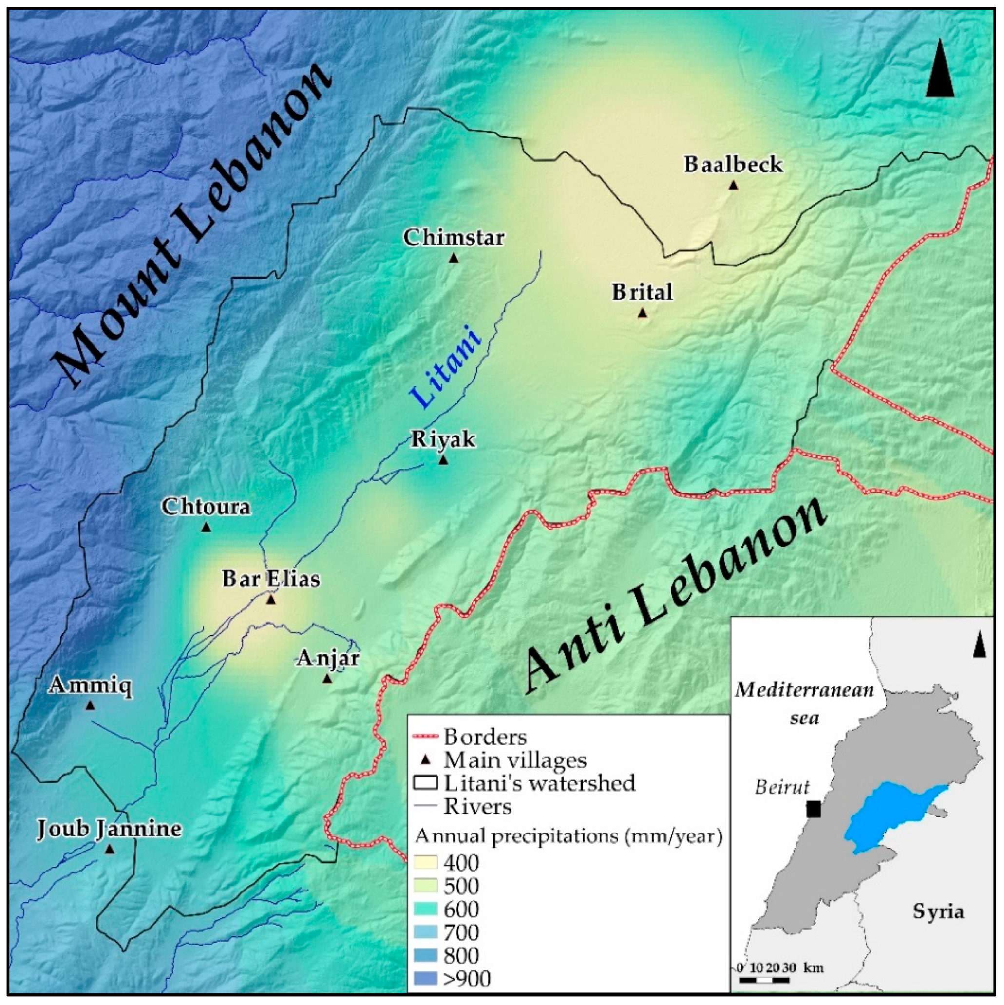
2.1. Crop Mapping of the Study Area
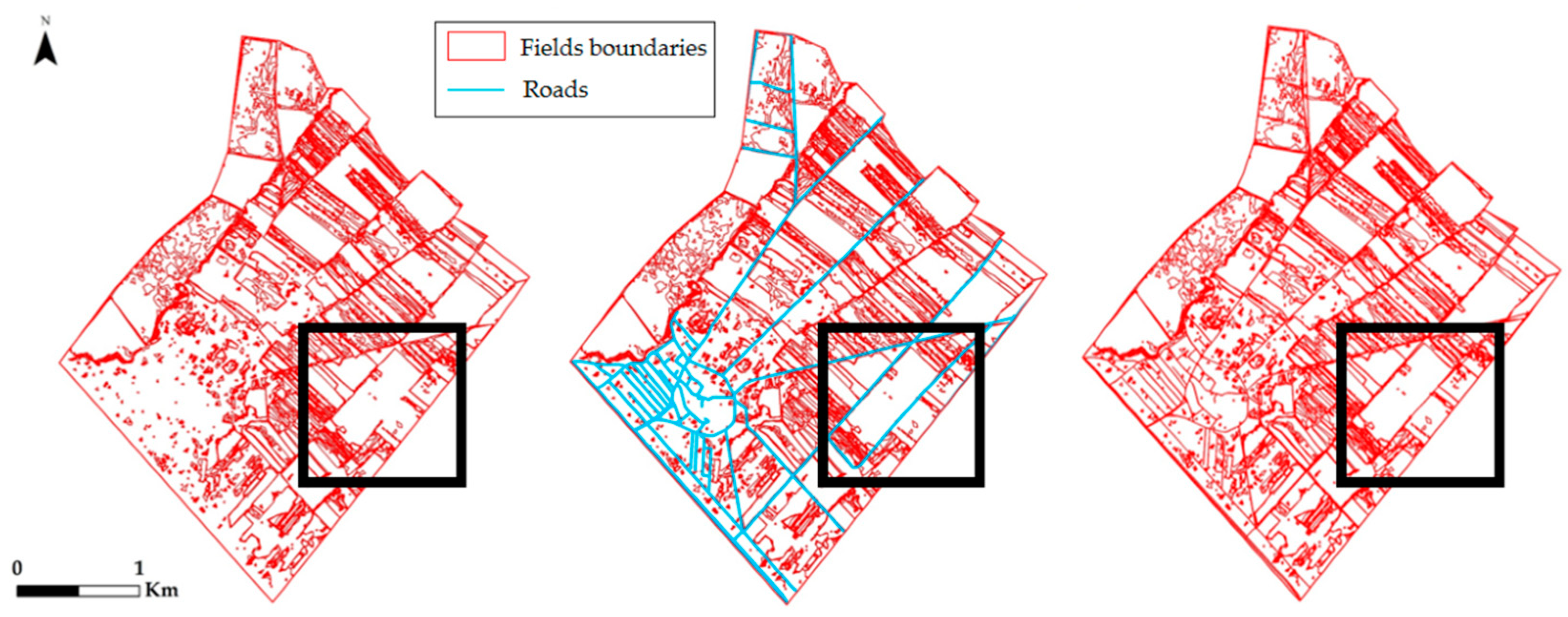
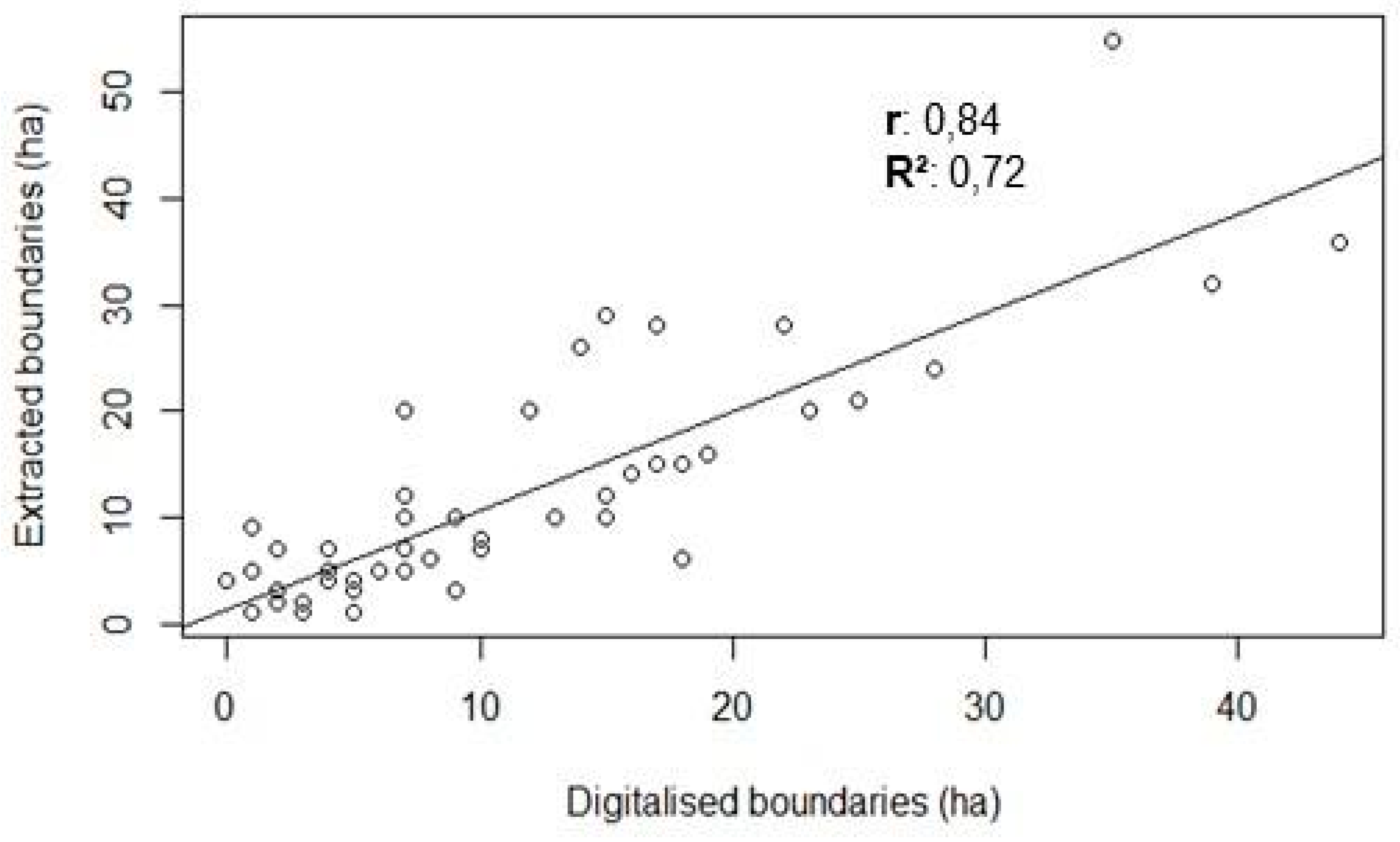
2.1.1. Delimitation of Field Boundaries
2.1.2. Sentinel-2 Image Processing
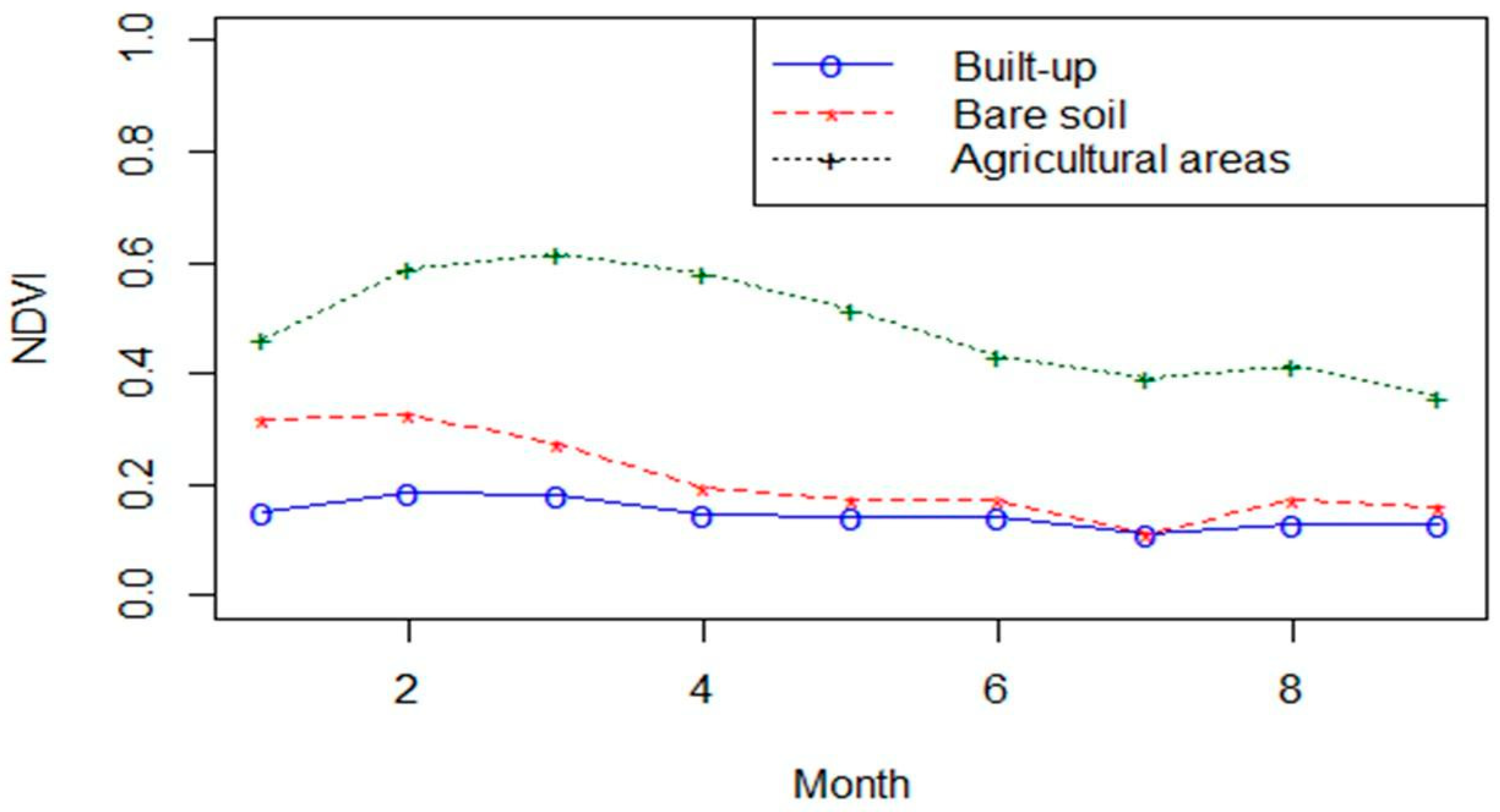
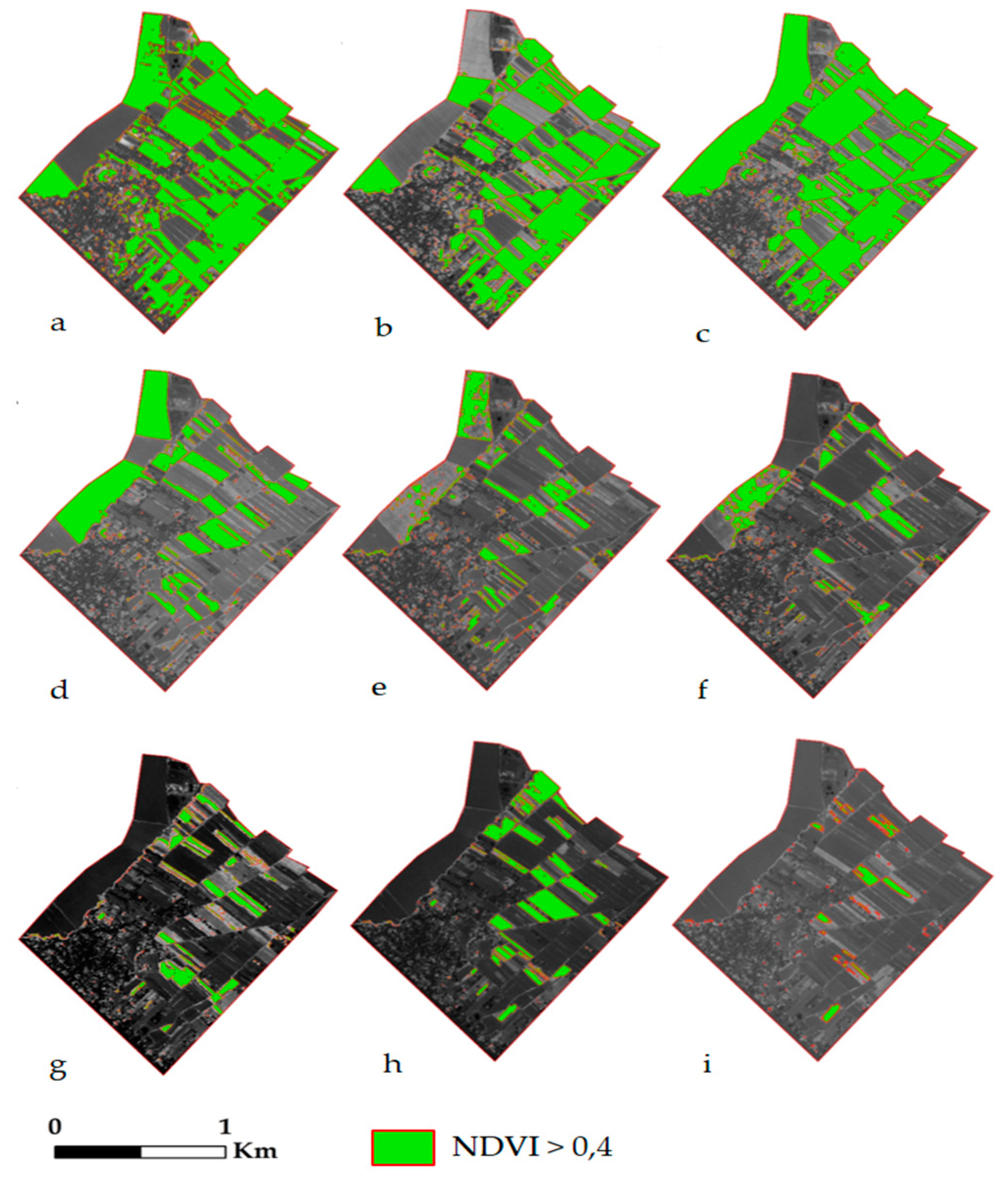
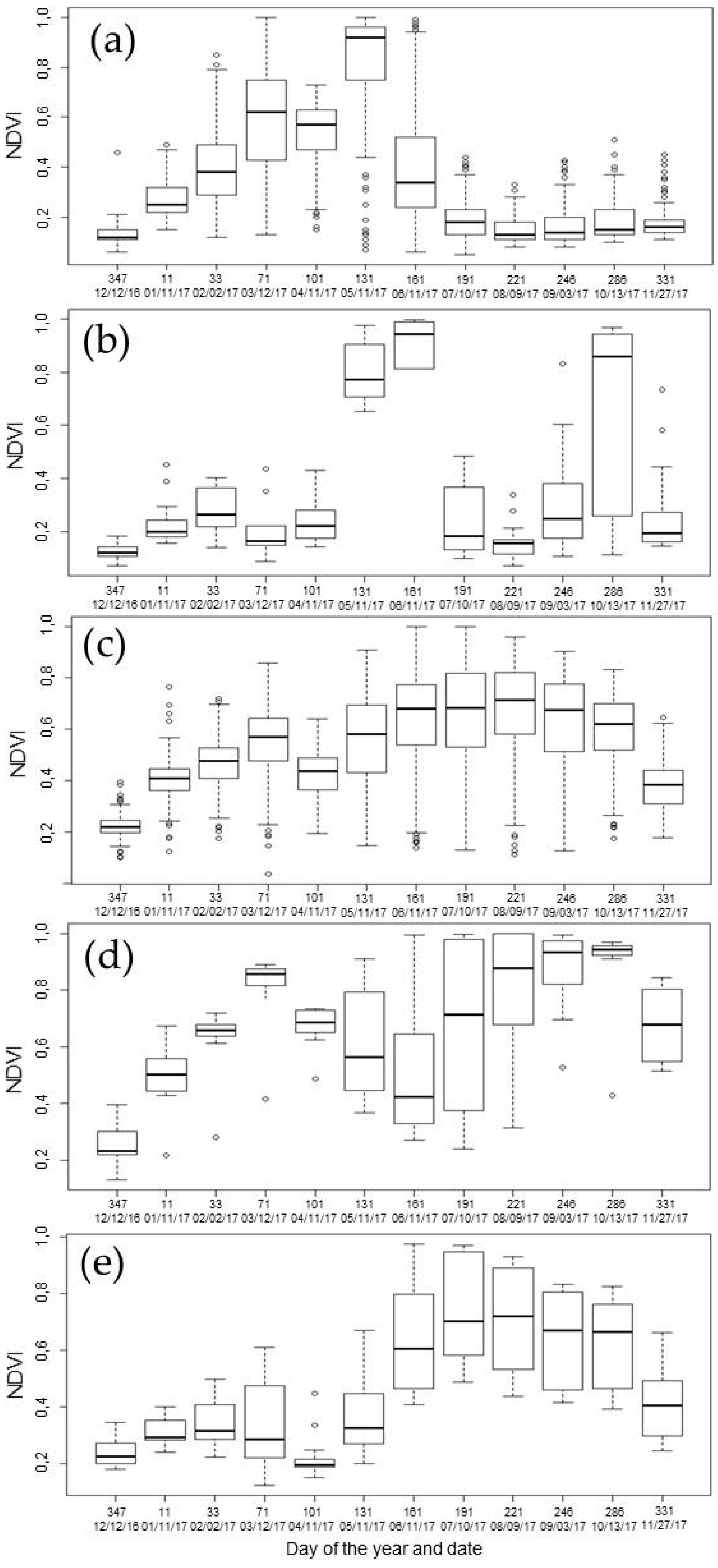
2.1.3. NDVI Evolution
2.1.4. Classification of NDVI Profiles
2.1.5. Euclidean Distance to Classify Crop Types
2.2. Socioeconomic and Statistical Approach of Farmer Crop Choices and Strategies: Surveys and Interviews with Farmers
2.2.1. Agricultural Profiles
2.2.2. Role of Government and Cooperatives
2.2.3. Abandoned Crops
2.2.4. Economic Influences on Farmers’ Strategy
3. Results
3.1. Absence of Agricultural Policies and Dependency on the Government: A Paradox
3.1.1. Current Main Crops: Results and Crop Map Validation
3.1.2. Survey Results: Agricultural Profiles and the Preference for Wheat
3.1.3. Dependence on the Market
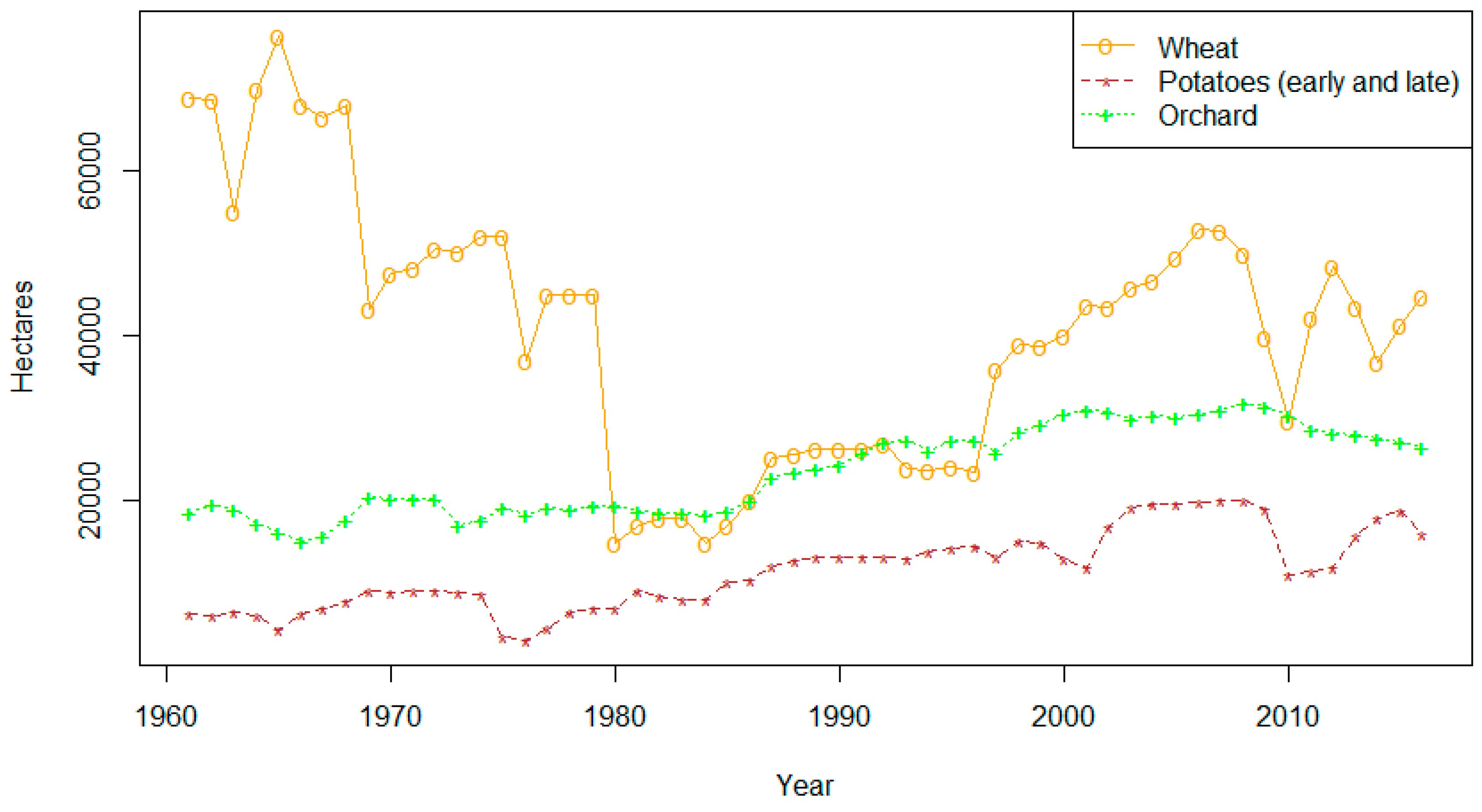
3.1.4. Increasing Crop Surface Area in Lebanon
3.2. Abandonment of Certain Crops
3.2.1. Farmers’ Crop Choice Evolution: Sugar Beet Policy
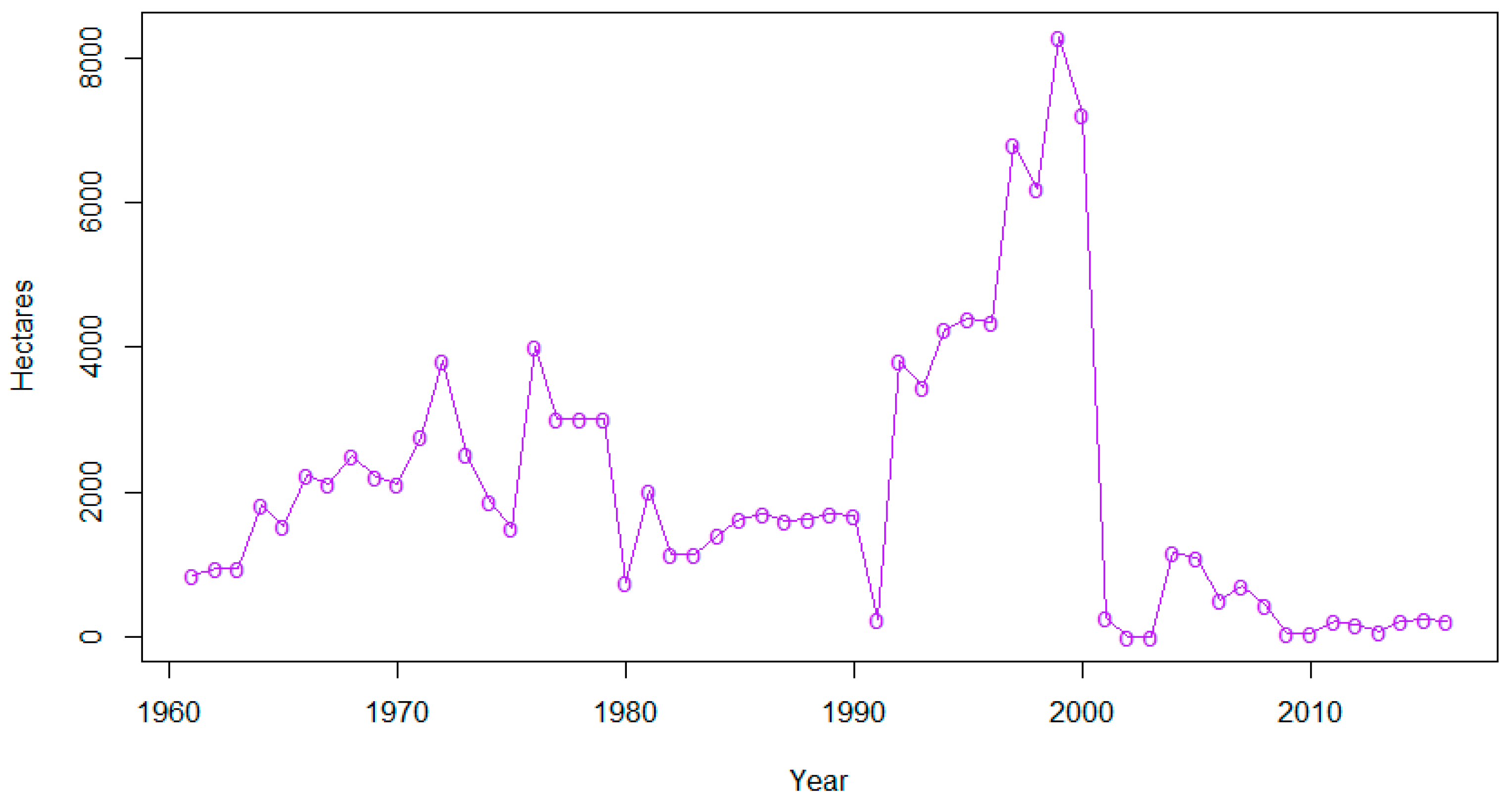
3.2.2. Cannabis: Decreasing Surface Area as a Result of Government Anti-Drug Interventions
3.2.3. Climate or Economy: Unbalanced Criteria
3.2.4. Searching for Alternatives
4. Discussion
4.1. Other Criteria of Crop Choices in Lebanon
4.1.1. Existence of a Private and Public Market
4.1.2. Farmer Isolation
4.1.3. High Adaptation Capacity or Farmer Autonomy
4.1.4. Low “Resistance” Capacity of Farmers’ Strategies
4.2. Integration of Remote Sensing and Socioeconomic Surveys
4.2.1. Crop Mapping: Perspectives and Interests
4.2.2. Support for Agricultural Census
4.2.3. Interest of the Cross-Sectorial Approach
5. Conclusions
Author Contributions
Conflicts of Interest
References
- Rastoin, J.-L.; Ferroukhi, S.A.; Abis, S.; Hainzelin, E.; Aliouat, B.; Hammoudi, A.; Benabderrazik, H.; Koné, S.; Cheriet, F.; Martin-Prével, Y. Afrique—Méditerranée—Europe: Pour une sécurité et une souveraineté alimentaires durables et partagées. IPEMED 2016, 9, 1–11. [Google Scholar]
- Montigaud, P. Les Filières Fruits et Légumes Frais Au Liban: Structures, Fonctionnement et Perspectives; INRA: Montpellier, France, 2004; pp. 1–61. [Google Scholar]
- Hervieu, B.; Abis, S. Les dynamiques agricoles en Méditerranée. Conflu. Méditerranée 2006, 58, 169–186. Available online: https://www.cairn.info/revue-confluences-mediterranee-2006-3-p-169.htm (accessed on 5 May 2018). [CrossRef]
- Abis, S.; Blanc, P. Chapitre 1—Le contexte sociodémographique. In MediTERRA 2008; Hervieu, B., Abis, S., Blanc, P., Jouvenel, A., Eds.; Presses Sciences: Po, France, 2008; pp. 31–56. [Google Scholar]
- Darwich, S. Enjeux de reconversion rurale dans la Béqaa (Liban): Politiques publiques et cultures illicites. In Environnement et Sociétés Rurales en Mutation: Approches Alternatives; Picouet, M., Sghaier, M., Genin, D., Abaab, A., Guillaume, H., Elloumi, M., Eds.; Latitudes 23-IRD: Marseille, France, 2004; pp. 323–339. [Google Scholar]
- Blanc, P. Développement régional et cohésion ‘nationale’. Conflu. Méditerranée 2006, 56, 115–129. Available online: https://www.cairn.info/revue-confluences-mediterranee-2006-1-page-115.htm (accessed on 6 March 2018). [CrossRef]
- Garçon, L.; Zurayk, R. Dans les Champs de la Bekaa. Le Monde Diplomatique, France, 2010; pp. 18–19. Available online: https://www.monde-diplomatique.fr/2010/09/GARCON/19645 (accessed on 22 March 2018).
- World Bank. Lebanon Agriculture Sector Note: Aligning Public Expenditures with Comparative Advantage; 68792; The World Bank: Washington, DC, USA, 2010; pp. 1–27. [Google Scholar]
- Allam, N. “Farming Is Like Gambling”: An Examination of the Decline of Produce Farming in Lebanon’s Central Bekaa Valley. Ph.D. Thesis, The George Washington University, Washington, DC, USA, May 2009. [Google Scholar]
- Ministère de l’Agriculture Libanais, FAO. Résultats Globaux Du Module de Base Du Recensement de L’ Agriculture 2010. Available online: http://www.agriculture.gov.lb/html/RESULTATS_RECENCEMENT_ AGRICULTURE_2010/RAPPORT_RESULTATS_GLOBAUX_DU_RECENCEMENT_2010.pdf (accessed on 20 June 2018).
- Balanche, F. Atlas Du Proche-Orient Arabe; PUPS: Paris, France, 2014; pp. 1–128. [Google Scholar]
- Blanc, P. Proche-orient: Le pouvoir, la terre et l’ eau. Géocarrefour 2014, 89, 228. [Google Scholar]
- Chehaita, B.; Ibrahim, M. L’agriculture au Liban: La nécessité d’une transition vers l’agriculture durable. Available online: https://www.lebarmy.gov.lb/fr/content/l%E2%80%99agriculture-au-liban-la-n%C3% A9cessit%C3%A9-d%E2%80%99une-transition-vers-l%E2%80%99agriculture-durable (accessed on 8 May 2018).
- Lamanthe, A. Extension des marchés et normalisation: Les systèmes agro-alimentaires dans la mondialisation, Summary. Géogr. Écon. Soc. 2007, 9, 257–270. [Google Scholar] [CrossRef]
- Caiserman, A. Identification and Classification of Cultivable Lands and Potential Sites for Hill Lakes Planning in the East of the Mediterranean Basin: The Case of the High-Jbeil (Lebanon). Ph.D. Thesis, University of Jean Moulin Lyon 3, Lyon, France, July 2016. [Google Scholar]
- Dercon, S. Risk, crop choice, and savings: Evidence from Tanzania. Econ. Dev. Cult. Chang. 1996, 44, 485–513. [Google Scholar] [CrossRef]
- Kurosaki, T.; Fafchamps, M. Insurance market efficiency and crop choices in Pakistan. J. Dev. Econ. 2002, 67, 419–453. [Google Scholar] [CrossRef] [Green Version]
- Huh, W.T.; Lall, U. Optimal crop choice, irrigation allocation, and the impact of contract farming. Prod. Oper. Manag. 2013, 22, 1126–1143. [Google Scholar] [CrossRef]
- Rahman, S. Determinants of crop choices by bangladeshi farmers: A bivariate probit analysis. In Agricultural Economics: New Research; Tomas, H., Ed.; Lee: London, UK, 2010; pp. 1–254. [Google Scholar]
- Ekasingh, B.; Ngamsomsuke, K. Searching for simplified farmers’ crop choice models for integrated watershed management in Thailand: A data mining approach. Env. Model. Softw. 2009, 24, 1373–1380. [Google Scholar] [CrossRef]
- Kibriya, S.; Savio, G.; Price, E.; King, J. The role of conflict in farmers crop choices in North Kivu, Democratic Republic of the Congo. Int. Food Agribus. Manag. Rev. 2016, 19, 1–20. [Google Scholar]
- Greig, L. An analysis of the key factors influencing farmer’s choice of crop, Kibamba Ward, Tanzania. J. Agric. Econ. 2009, 60, 699–715. [Google Scholar] [CrossRef]
- Kenduiywo, B.K.; Bargiel, D.; Soergel, U. Crop-type mapping from a sequence of sentinel 1 images. Int. J. Remote Sens. 2018, 39, 6383–6404. [Google Scholar] [CrossRef]
- Zhong, L. Efficient Crop Type Mapping Based on Remote Sensing in the Central Valley, California. Ph.D. Thesis, UC Berkeley, Berkeley, CA, USA, 2012. [Google Scholar]
- Singha, M.; Wu, B.; Zhang, M. Object-based paddy rice mapping using HJ-1A/B data and temporal features extracted from time series MODIS NDVI data. Sensors 2017, 17, 10. [Google Scholar] [CrossRef] [PubMed]
- Song, Q.; Hu, Q.; Zhou, Q.; Hovis, C.; Xiang, M.; Tang, H.; Wu, W. In-season crop mapping with GF-1/WFV data by combining object-based image analysis and random forest. Remote Sens. 2017, 9, 1184. [Google Scholar] [CrossRef]
- Pittman, K.; Hansen, M.C.; Becker-Reshef, I.; Potapov, P.V.; Justice, C.O. Estimating global cropland extent with multi-year MODIS data. Remote Sens. 2010, 2, 1844–1863. [Google Scholar] [CrossRef]
- Biradar, C.M.; Thenkabail, P.S.; Turral, H.; Noojipady, P.; Jie, L.Y.; Velpuri, M.; Dheeravath, V.; Vithanage, J.; Schull, M.; Cai, X.L.; et al. A global map of rainfed cropland areas at the end of last millennium using remote sensing and geospatial techniques. In Geoinformatics 2006: GNSS and Integrated Geospatial Applications; International Society for Optics and Photonics: San Francisco, CA, USA, 2006. [Google Scholar]
- Waldhoff, G.; Lussem, U.; Bareth, G. Multi-data approach for remote sensing-based regional crop rotation mapping: A case study for the rur catchment, Germany. Int. J. Appl. Earth Obs. Geoinf. 2017, 61, 55–69. [Google Scholar] [CrossRef]
- Heupel, K.; Spengler, D.; Itzerott, S. A progressive crop-type classification using multitemporal remote sensing data and phenological information. PFG 2018, 86, 53–69. [Google Scholar] [CrossRef]
- Hao, P.; Tang, H.; Chen, Z.; Liu, Z. Early-season crop mapping using improved artificial immune network (IAIN) and sentinel data. PeerJ 2018, 6. [Google Scholar] [CrossRef] [PubMed]
- Khan, M.R.; de Bie, C.A.J.M.; van Keulen, H.; Smaling, E.M.A.; Real, R. Disaggregating and mapping crop statistics using hypertemporal remote sensing. Int. J. Appl. Earth Obs. Geoinf. 2010, 12, 36–46. [Google Scholar] [CrossRef]
- European Commission. Agricultural Monitoring. Available online: https://ec.europa.eu/jrc/en/research-topic/agricultural-monitoring (accessed on 4 March 2019).
- FAO. AQUASTAT—FAO’s Information System on Water and Agriculture. Available online: http://www.fao.org/nr/water/aquastat/countries_regions/LBN/ (accessed on 14 July 2018).
- Sanlaville, P. Les régions agricoles du Liban. Géocarrefour 1963, 38, 47–90. [Google Scholar] [CrossRef] [Green Version]
- Touma, T.H. Le paysan et la terre au Liban aux XVIII e et XIX e siècles. Civilisations 1966, 16, 233–241. [Google Scholar]
- Lateef, A.S. Geological history of the Bekaa Valley—Lebanon. In Second International Conference on the Geology of the Tethys; Cairo University: Cairo, Egypt, 2007; pp. 391–402. [Google Scholar]
- Lebanese Agriculture Research Institute. Climate Data, Unpublished work.
- Akbari, M.; Mamanpoush, A.; Gieske, A.; Miranzadeh, M.; Torabi, M.; Salemi, H.R. Crop and land cover classification in Iran using landsat 7 imagery. Int. J. Remote Sens. 2006, 27, 4117–4135. [Google Scholar] [CrossRef]
- Awad, M.; Darwish, T. Possible field crops mapping and assessment in Lebanon using SENTINEL-2 images and GIS; ESA-ESRIN: Frascati, Italy, 2014; pp. 1–4. [Google Scholar]
- Zafar, S.; Waqar, M.M. Crop type mapping by integrating satellite data and crop calendar over Okara district, Punjab—Pakistan. J. Space Technol. 2014, 4, 21–25. [Google Scholar]
- Asgarian, A.; Soffianian, A.; Pourmanafi, S. Crop type mapping in a highly fragmented and heterogeneous agricultural landscape: A case of central Iran using multi-temporal landsat 8 imagery. Comput. Electron. Agric. 2016, 127, 531–540. [Google Scholar] [CrossRef]
- Morawitz, D.F.; Blewett, T.M.; Cohen, A.; Alberti, M. Using NDVI to assess vegetative land cover change in central Puget sound. Env. Monit. Assess. 2006, 114, 85–106. [Google Scholar] [CrossRef] [PubMed]
- ESA. Sen2Cor. Available online: http://step.esa.int/main/third-party-plugins-2/sen2cor/ (accessed on 8 May 2018).
- Turker, M.; Kok, E.H. Field-based sub-boundary extraction from remote sensing imagery using perceptual grouping. Isprs J. Photogramm. Remote Sens. 2013, 79, 106–121. [Google Scholar] [CrossRef]
- Campbell, J.B.; Wynne, R.H. Introduction to Remote Sensing, 5th ed.; Guilford Press: New York, NY, USA, 2011; pp. 1–667. [Google Scholar]
- Abade, N.A.; de Júnior, O.A.C.; Guimarães, R.F.; de Oliveira, S.N. Comparative analysis of MODIS time-series classification using support vector machines and methods based upon distance and similarity measures in the Brazilian Cerrado-Caatinga boundary. Remote Sens. 2015, 7, 12160–12191. [Google Scholar] [CrossRef]
- Congalton, R.G. A review of assessing the accuracy of classifications of remotely sensed data. Remote Sens. Env. 1991, 37, 35–46. [Google Scholar] [CrossRef]
- Ministry of Finance. Wheat and Bread Subsidies; UNDP: Beirut, Lebanon, 2012; pp. 1–24.
- Bennafla, K. Le développement au péril de la géopolitique: L’exemple de la plaine de la Békaa (Liban). Géocarrefour 2006, 81. [Google Scholar] [CrossRef]
- Purseigle, F.; Hervieu, B. Pour une sociologie des mondes agricoles dans la globalization. For a sociology of agricultural worlds during globalization. Etudes Rural. 2009, 183, 177–200. [Google Scholar]


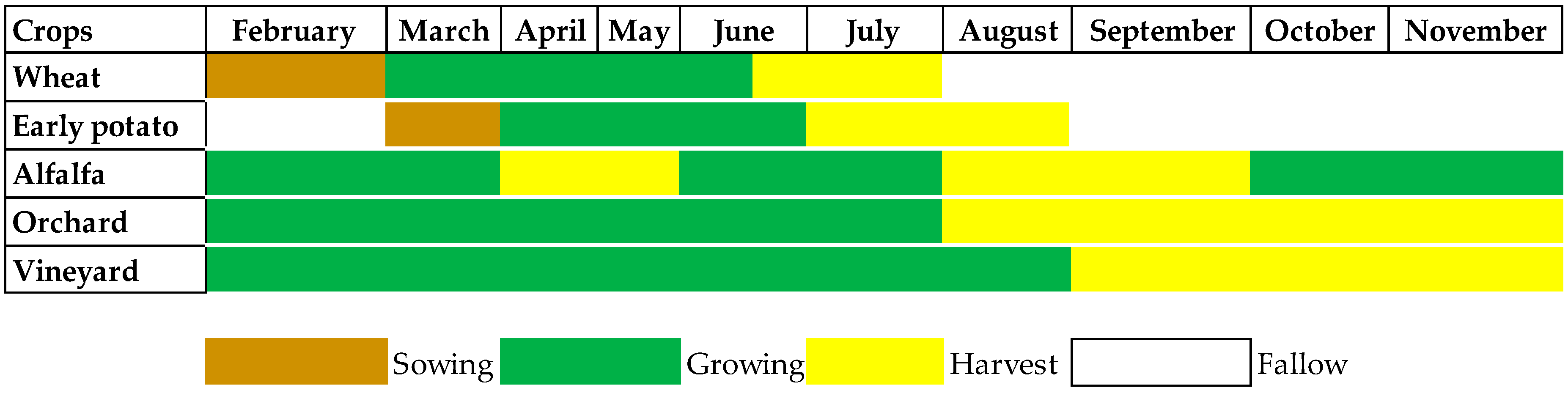
| Crop Type: | Alfalfa | Orchard | Early Potato | Vineyard | Wheat | Total |
|---|---|---|---|---|---|---|
| Known fields | 10 | 134 | 63 | 18 | 161 | 386 |
| Group a | 5 | 67 | 32 | 9 | 81 | 194 |
| Group b | 5 | 67 | 31 | 9 | 80 | 192 |
| Crop-Map Results | Socioeconomic-Survey Results | ||||
|---|---|---|---|---|---|
| Crops | Surface (km2) | Surface (ha) | Surface of the Plain (%) | % of Farmers Cultivating the Related Crop | Cultivated Area (ha) |
| Wheat and barley | 115.294 | 11,527.4 | 32.5 | 87 | 106 |
| Early potatoes | 90.2 | 9026.3 | 25.5 | 56 | 68 |
| Spring vegetables | 83 | 8306.5 | 23.4 | 80 | 30 |
| Orchards | 39.7 | 3972.4 | 11.2 | 46 | 4.5 |
| Vineyards | 25.8 | 2581.8 | 7.3 | 10 | 75 |
| Alfalfa | 0.2 | 25.8 | 0.1 | 12 | 21 |
| Total | 354.1 | 35,400 | 100 | - | - |
| Average | - | - | - | - | 50.75 |
| Alfalfa | Early Potato | Vineyard | Wheat | Orchard | Bare Soil | Urban | Total | |
|---|---|---|---|---|---|---|---|---|
| Alfalfa | 5 | 0 | 0 | 0 | 0 | 0 | 0 | 5 |
| Early potato | 0 | 30 | 0 | 1 | 0 | 0 | 0 | 31 |
| Vineyard | 0 | 1 | 7 | 0 | 1 | 0 | 0 | 9 |
| Wheat | 0 | 8 | 0 | 69 | 2 | 1 | 0 | 80 |
| Orchard | 1 | 2 | 2 | 4 | 58 | 0 | 0 | 67 |
| Bare soil | 0 | 0 | 0 | 0 | 0 | 3 | 0 | 3 |
| Urban | 0 | 0 | 0 | 0 | 0 | 0 | 8 | 8 |
| Total | 6 | 41 | 9 | 74 | 61 | 4 | 8 | 203 |
| Crops | Accuracy % | Recall % | Precision % |
|---|---|---|---|
| Alfalfa | 100.00 | 100.00 | 83.33 |
| Early potato | 96.67 | 96.77 | 73.17 |
| Vineyard | 71.43 | 77.78 | 77.78 |
| Wheat | 84.06 | 86.25 | 93.24 |
| Orchard | 84.48 | 86.57 | 95.08 |
| Bare soil | 100.00 | 100.00 | 75.00 |
| Urban | 100.00 | 100.00 | 100.00 |
© 2019 by the authors. Licensee MDPI, Basel, Switzerland. This article is an open access article distributed under the terms and conditions of the Creative Commons Attribution (CC BY) license (http://creativecommons.org/licenses/by/4.0/).
Share and Cite
Caiserman, A.; Dumas, D.; Bennafla, K.; Faour, G.; Amiraslani, F. Application of Remotely Sensed Imagery and Socioeconomic Surveys to Map Crop Choices in the Bekaa Valley (Lebanon). Agriculture 2019, 9, 57. https://doi.org/10.3390/agriculture9030057
Caiserman A, Dumas D, Bennafla K, Faour G, Amiraslani F. Application of Remotely Sensed Imagery and Socioeconomic Surveys to Map Crop Choices in the Bekaa Valley (Lebanon). Agriculture. 2019; 9(3):57. https://doi.org/10.3390/agriculture9030057
Chicago/Turabian StyleCaiserman, Arnaud, Dominique Dumas, Karine Bennafla, Ghaleb Faour, and Farshad Amiraslani. 2019. "Application of Remotely Sensed Imagery and Socioeconomic Surveys to Map Crop Choices in the Bekaa Valley (Lebanon)" Agriculture 9, no. 3: 57. https://doi.org/10.3390/agriculture9030057
APA StyleCaiserman, A., Dumas, D., Bennafla, K., Faour, G., & Amiraslani, F. (2019). Application of Remotely Sensed Imagery and Socioeconomic Surveys to Map Crop Choices in the Bekaa Valley (Lebanon). Agriculture, 9(3), 57. https://doi.org/10.3390/agriculture9030057