1. Introduction
Land evaluation is a foundation for sustainable land resource planning, management and finding optimum land use for each defined land unit [
1]. Land cover is the biophysical features of land and the land use refers to the socio-economic functions of land to meet human needs [
2,
3]. Appropriate land use decisions are vital to achieving optimum land productivity and ensuring environmental sustainability. This requires an effective management of land information on which such decisions should be based [
4]. The Food and Agricultural Organization [
5,
6] recommended a land suitability assessment approach for crops in terms of suitability ratings ranging from very highly suitable to unsuitable based on climatic and terrain data, as well as soil properties. Land suitability evaluation according to FAO standards has been applied in many parts of the world, particularly in the developing countries.
The planting of tea in Sri Lanka has been carried out since 1860 and it has become the mainstay of the island’s economy [
7]. Of the agricultural land, 40% is used for plantation agriculture—of which 28% is used for tea cultivation [
8]. The major constraints of the tea sector in Sri Lanka are the limited area of suitable terrain, which keep land prices high and the average estate size small, and labor shortage [
9]. Thus, the selection of land according to its suitability has become increasingly important in making the best use of available land for tea cultivation. Farmers establish tea based on prior knowledge and experience, without the availability of scientific information and validation. So, farmers definitely consider site suitability but using a different set of information. This adversely impacts on tea production and, in the long run, would exacerbate the existing economic, social, and environmental problems related to the tea sector.
Further, land use activity contributes to climate change and the impact of climate and natural disasters has increased in recent decades due to improper land use in Sri Lanka [
10]. Tea cultivation in Sri Lanka is clearly vulnerable to climate change and extreme events, and this has resulted in some of the existing tea land area becoming unsustainable for tea cultivation and, by contrast, existing marginal land has been morphed into cultivated land [
11]. Other ramifications of climate change are receiving longer dry seasons, uneven rainfall distribution, and erosion of top soil caused by uncharacteristic heavy rainfall patterns, which can lead to negative effects on production. In addition, crop-weed competition, the spread of pests and diseases, drought damage, soil losses and infertility in tea fields fostering the increased use of fertilizers to maintain the soil fertility, resulting in an increase in the cost of production and posing a threat to the tea industry [
12,
13]. Commercial tea growing in Sri Lanka, limited to a few areas, is at risk due to climate change and its subsequent fallouts. Consequently, the expected production in response to the demand may not be as easy as in the earlier days under given potential constraints on the availability of suitable tea lands [
14].
This situation has also aggravated the current status of tea cultivation in Sri Lanka through construction and other human activities and, correspondingly, there is a great risk of a lower return on investment in tea cultivation [
15]. For example, forest areas and tea lands in hilly areas have been converted for human settlement and the cultivation of annual crops, which has resulted in soil erosion, soil infertility, landslides and floods. The National Building Research Organization (2015) identified that seven tea-growing districts of Sri Lanka (i.e., Badulla, Nuwara Eliya, Kegalle, Ratnapura, Kandy, Matale and Kalutara) are subjected to severe landslides that demarcate nearly 12,000 km
2 (21%) of the total area of Sri Lanka. Therefore, the extent of the major tea producing area is apparently threatened and not sustainable to produce a high quantity of tea to cater for global demand. Moreover, land use policies in Sri Lanka are not designed to ensure that economies of scale in production and cropping and that farming systems are sustainable in the long run [
16]. Also, the productivity of fertile lands has been reduced due to improper land use [
10] and this can lead to the mismanagement of natural resources and degradation of the environment with other socio-economic conflicts [
17].
Under the current economic trends and the nature of commercialization, tea planters and related companies are more interested in converting the estate bungalows into tourist hotels, cutting down trees in the estates for timber, extracting granite and other mineral resources and selling the land at the end [
18]. The public railed against some multipurpose development projects especially implemented in hilly areas (i.e., the irrigation project of Uma oya) for wreaking unsafe levels of environmental damage and thus thousands of acres of tea lands are becoming unusable or less suitable for tea growing [
19]. Hence the responsible authorities should shoulder the responsibility to take initiatives to only make use of the unproductive tea lands for the above-mentioned activities, leaving the suitable lands for the long-term sustainability of tea cultivation. Approximately 80% of the population concentrated in the tea plantation sector are Tamil people who immigrated to Sri Lanka from South India during the British colonial era in the 19th century. Most of the workers in the tea estates reside within the estate area itself and work as laborers. The clusters of the labor lines are strategically located in different parts of the tea estate to enable quick labor deployment and to protect the boundary of the tea plantations. But with the increase of population in communities attached to the tea industry, tea plantation workers demand land for constructing their own settlements and fight for their rights for lands as they have no choice [
20]. Sometimes they establish their settlements illegally in tea lands, clearing the existing tea cultivation and adjacent forest areas. Thus, it is obvious that immediate steps must be taken to form a national policy and strategy on these circumstances by giving special reference to the land management practices in tea plantations.
In conjunction with the above circumstances, the existing tea-growing areas in Sri Lanka that were identified in the early 1940s may not be suitable for tea anymore or some other areas may have suitable conditions to grow tea. The total land area under tea cultivation was estimated to be approximately 221,969 hectares in 2016 [
12], but the area under tea has decreased by 10% from 1946 to 1982 [
8]. Based on the figures given by Food and Agriculture Organization (FAO) Statistical Databases [
13], we estimate that the tea cultivation area decreased by 2.6% from 1961 to 2016 while other tea producing countries substantially increased their cultivation extent. The land area for tea cultivation in Sri Lanka has not increased compared to other tea producing countries like Kenya, China and India, which creates difficulties in competing in the international market in the future [
14]. Therefore, urgent attention has to be drawn to implement proper land use planning and to work on suitability analysis for tea in order to upgrade the productivity and to avoid land use-related problems in tea cultivation [
21].
In the global context, a number of studies have been undertaken to assess the land suitability assessment for tea crops. In Kenya, a land use assessment was done for tea, particularly in Kirinyage region using the MaxEnt Species Distribution Model [
17], quantitative and economic land suitability has been assessed for tea in Gulian province in Iran using the Square root and the Storie methods [
18], and the land suitability assessment was conducted in the Kabarole District of Western Uganda for tea and food crops using a model built in Automated Land Evaluation System (ALES) software by means of decision trees [
19]. A comprehensive suitability evaluation was carried out by Bo, Zhang [
22] for tea in Southern China using the Geographic Information System (GIS) and modified land ecological suitability evaluation model, providing the scientific basis and reference for the rational distribution of the tea crops, while Gahlod, Binjola [
20] carried out an evaluation for tea, cardamom and rubber cultivations in Kerala, making use of environmental and variety of soil physio-chemical parameters. These types of studies provide information on the constraints and opportunities for the use of the land and therefore guide in decision making on optimal utilization of land resources [
23].
The present land use pattern in Sri Lanka is a legacy of the land policy of the colonial past, where export-based commercial plantations like tea were superimposed on a traditional subsistence farming system. Today, the tea industry is considered as one of the largest agro-based industries in Sri Lanka and the land suitability assessment will help to achieve maximum sustained production. Until recently, many decisions on land use matters in Sri Lanka were taken on an ad hoc basis, using the local knowledge and intuition of the officers concerned. An inadequate number of studies have been conducted to enable informed decisions on the proper utilization of lands for tea plantation in Sri Lanka, and they have not taken the factors of topography, soil, climate and management into account. The first such attempt was made by Panabokke [
24], who identified the main regions for tea and rubber. This gave a general assessment of the land suitability for tea, but no criteria of suitability were given [
25]. Jayathilaka, Soni [
26] generated crop suitability maps for tea, amalgamating yield maps and climatic factors maps using the Analytic Hierarchy Process (AHP) in multi-criteria analysis under two times frames of 1980–1992 and 1993–2007. The selected study area only covers five agro-ecological zones (AEZs) between the coordinates of 6° and 7°30’N latitude and 79°50’ to 81°E longitude. They only considered climate parameters such as temperature, rainfall, relative humidity and evapotranspiration with yield factors whereas our study addresses climatic as well as topographical and soil parameters in order to study the suitability of land for tea. Land Utilization Committee and Tea Commission of Sri Lanka conducted a comprehensive assessment of the unsuitability of tea plantation lands and the feasibility of rehabilitation and diversification in 1968 considering available data for slope, rockiness, soil depth, drainage, soil erosion, nutrition status, rainfall and temperature. A case study was undertaken to classify and to map the tea-growing areas in Ratnapura District [
27], but climatic factors were not taken into consideration for this study.
Also, land use planning for tea by individual site assessment using the traditional method is subjective and a time-consuming procedure [
27,
28]. Although a few studies have been undertaken [
25,
29,
30] to map the suitability of lands for tea cultivation, they did not cover the entire tea-growing region of the country. In the given context, no initiative has yet been taken by the Sri Lankan Tea Research Institute to classify land or existing tea-growing areas to varying degrees of suitability.
It is usually difficult to make a detailed and precise analysis because of the inappropriate understanding of evaluation factors and weights in practice [
31]. The availability of GIS and Multi-Criteria Decision Analysis (MCDM) methods allows the combination of knowledge from different sources to support land use planning and management [
32,
33]. The most commonly used MCDM are the AHP, weighted linear combination, ordered weighted averaging, ELECTRE, DEMATEL, PROMETHEE, VIKOR and multiple-objective land allocation [
34,
35]. The AHP has advantages over conventional multi-attribute utility methods, consisting of the hierarchical breakdown of the particular decision problem and the use of subjective and verbal expressions to determine the relative importance of the criteria [
35]. The main drawbacks of the AHP indicated by literature are potential internal inconsistency and the dubious theoretical base of the rigid 1–9 scale, together with the possibility of rank reversal following the introduction of a new alternative [
36,
37]. Also, the AHP is incapable of finding the interdependence between criteria which does not address the influences and effects that each of them has on other factors. The DEMATEL method is generally used to establish interactive relationships among criteria [
38,
39,
40]. In addition, this allows to estimate both the importance of criteria and shows the causal relations of factors [
41]. This method was originally developed by the Science and Human Affairs Program of the Battelle Memorial Institute of Geneva between 1972 and 1976 [
42]. DEMATEL technique has been used in a broad spectrum of fields because of its capacity to handle complex relationships between components of a system [
43].
Compared with other MCDMs, the DEMATEL method has many advantages such as it effectively analyzes both direct and indirect effects among different criteria, understands the cause and effect relationships in the decision-making problem, is able to visualize the interrelationships between factors via a causal diagram, and enables the decision maker to clearly understand which factors have mutual influences on one another. The DEMATEL method can be used not only to determine the ranking of alternatives, but also to find out critical evaluation criteria and measure the weights of evaluation criteria [
42]. Although the AHP can be implemented to rank alternatives and determine criteria weights, it assumes the criteria are autonomous and their interactions and dependencies are not considered. The DEMATEL technique also has some drawbacks compared to other techniques of MCDMs. It determines the ranking of alternatives based on interdependent interactions between them, but other criteria are not included in the issue of decision-making. It cannot take into account the aspiration level of alternatives or obtain partial ranking orders of alternatives. Therefore, DEMATEL has been incorporated with other MCDM techniques to combine other necessary characteristics in many previous studies [
43]. A combined AHP–DEMATEL technique has been used approximately the globe in many land suitability assessments [
44,
45,
46,
47].
The land suitability assessment for tea is important for identifying the potential areas for maximizing the production and to suggest ameliorating measures for better crop management [
20]. The suitability analysis allows recognizing marginal suitable areas which facilitate decision makers to identify limiting factors and enable them to formulate appropriate management decisions (i.e., new planting, replanting, infilling, diversification, and adopting climate-friendly best practices) for increasing the productivity of the land. An exhaustive study needs to be carried out to determine appropriate land use in the unproductive estates giving due consideration to other factors. Also, this allows stakeholders to identify new areas where tea can be planted in accordance with the requirements of the tea crops, emphasizing the qualities of the land unit. Hence, matching crop requirements with available resources through land suitability analysis has become an urgent need to sustain agricultural land productivity in Sri Lanka.
The previous sections show that no comprehensive study has been undertaken in Sri Lanka to look at land suitability for tea cultivation using both physical (soil properties and topography) and climate factors. This shows the need for the rationalization of land use, where the available land should be selected according to the crop requirements and it has become enormously important in making the best use of the land available in Sri Lanka for tea cultivation. Therefore, in this study, an attempt has been made to assess the land suitability for tea in order to ensure the long-term progression in the tea sector towards a sustainable tea production. The geographical information system-based multi-criteria approach was used to identify potential, suitable and unsuitable areas and information about the type of limitation (s) facing the utilization of the land for tea cultivation. The research value and novelty of this study is the simultaneous utilization of the AHP and DEMATEL methods to assess the land suitability for tea crops.
4. Discussion
Selecting the most rational algorithm for assessing the land suitability is crucial for current and future land use planning for tea cultivation. A key step in the land suitability assessment for crop production is to determine the weight of each factor affecting the land suitability [
77]. The presence of different and multiple criteria complicates the assessment of land suitability because factors affecting land suitability are of unequal significance [
78]. The AHP and DEMATEL methods have been widely reported in literature [
40,
43,
46,
79,
80]. In this study we used an integrated multiple criteria decision-making (MCDM) technique that combines the AHP and DEMATEL. Our decision to integrate the DEMATEL approach with the AHP was because one of the weaknesses of the AHP is the fact that it does not allow for evaluating interrelations and influences between the elements that compose the decision-making process. Application of the DEMATEL method allows not only the description of the structure and interrelationships between the criteria, but also allowed us to identify the key criteria influencing tea with regard to land suitability [
43]. Further, the results of the AHP are often taken into consideration when making short-term decisions. The DEMATEL technique, on the other hand, evaluates both the importance of criteria and shows the causal diagram which could assist in enhancing the long-term impacts of choices. The integration of the AHP and DEMATEL techniques thus offers the decision maker comprehension to enhance efficiency from either short-term or long-term points of view [
79]. The integrated approach of GIS and the AHP–DEMATEL technique in this study has great potential to classify the land suitability of tea plantations. No previous studies have been conducted in Sri Lanka and the holistic approach of GIS and the AHP–DEMATEL technique are hence used for the first time to determine the suitability of tea lands. This study represents the efficacy of the AHP and weighted overlay model for the land suitability analysis of tea resulting in a CR value less than 0.1 (
Table 5). The paired comparison matrix used in this study therefore appears to have sufficient internal consistency to be considered acceptable. Furthermore, the DEMATEL technique confirmed the importance of the criteria chosen from the AHP analysis to use in the tea suitability assessment process.
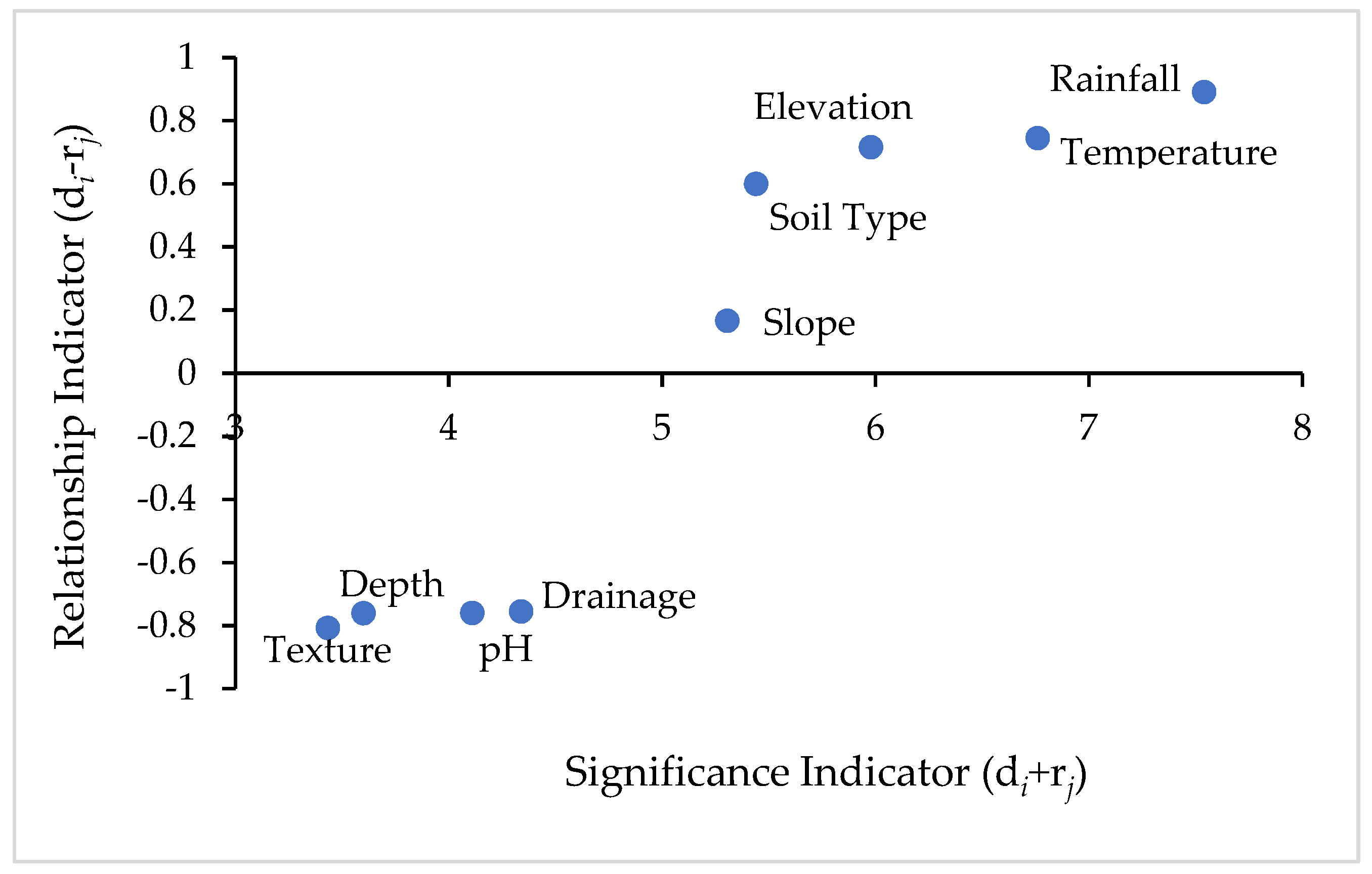
The soil, topography and climate factors are critical and necessary for successful tea cultivation [
27]. All criteria which are considered as relevant for a land suitability decision are compared against each other in a pair-wise comparison matrix which is a measure to express the relative preference among the factors (
Table 10). On the basis of the results, the total suitability of rainfall and temperature were given a high average weight in the AHP–DEMATEL technique compared to the total suitability of the other topographic and soil factors since these variables were the most restrictive factors for the assessment of land suitability for tea [
26,
48,
52]. The climate is the most important factor that determines the land suitability of tea [
26,
81]. Rainfall in fact influences all other meteorological elements, including temperature, and the present agricultural land use of Sri Lanka already underlines the effects of rainfall upon land use [
4,
51]. Therefore, in matrix comparison AHP and DEMATEL, rainfall is considered as equally or moderately important than temperature (
Table 4,
Table 9 and
Table 10).
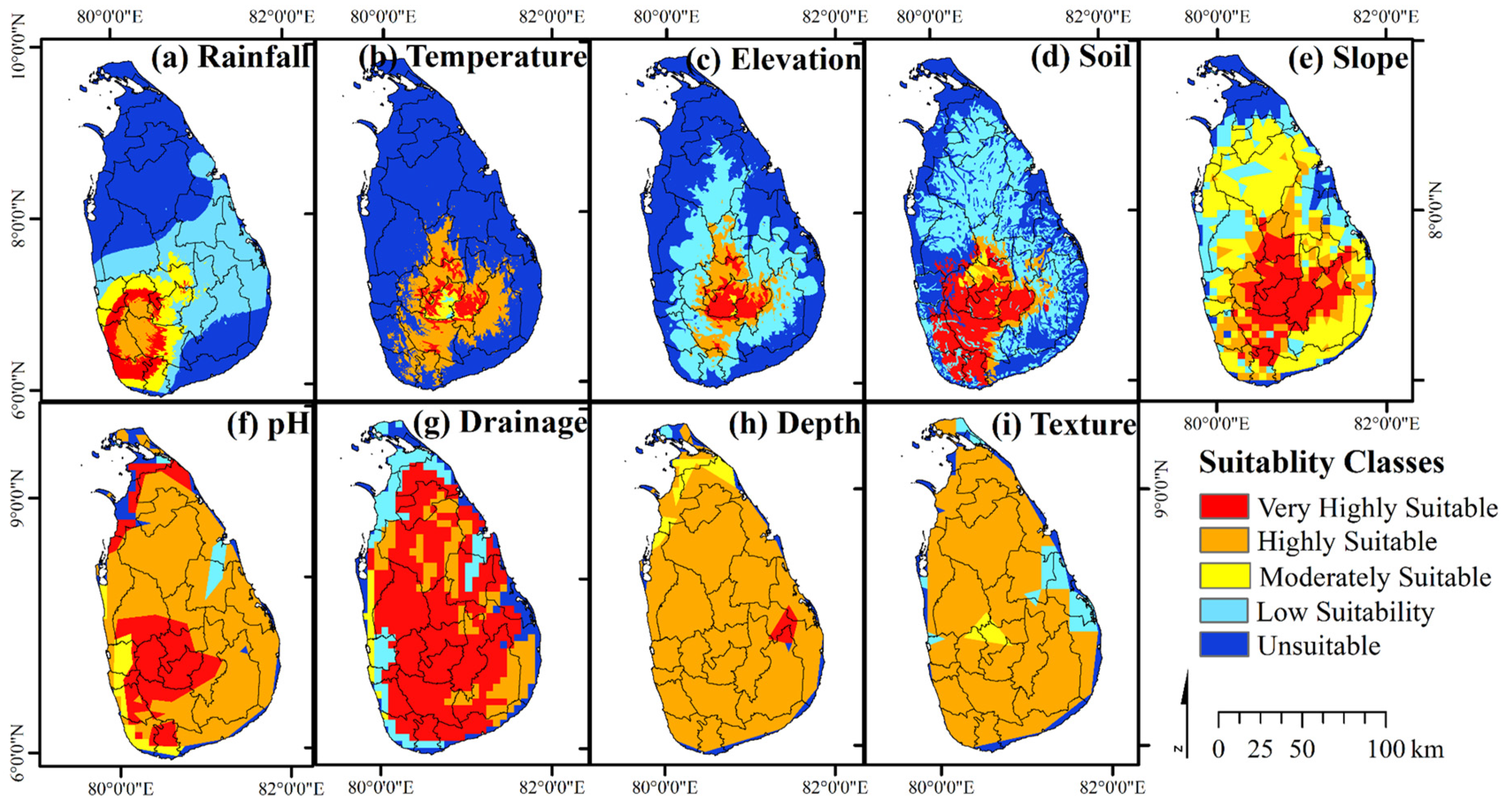
The actual spatial variation of crop cultivation is often modified by different types of soil with varying physical, chemical and biological properties and thus determining the land suitability for tea [
81]. In the analysis of the land suitability for tea, slope is another key determinant [
60] which is given high priority compared to other soil characteristics (
Table 10). The lack of reliable country-specific soil data can significantly hamper interventions to assess land suitability. There is no clear and detailed coverage of point-based soil profile data in Sri Lanka. Since there are no country-specific data available at the desirable scale, data were extracted from the Harmonized World Soil Database which is readily available on FAO soils portal (
Figure 3). Land suitability mapping can only be used as a first step in spatial planning, since the actual suitability can only be assessed on the basis of a detailed investigation [
82].
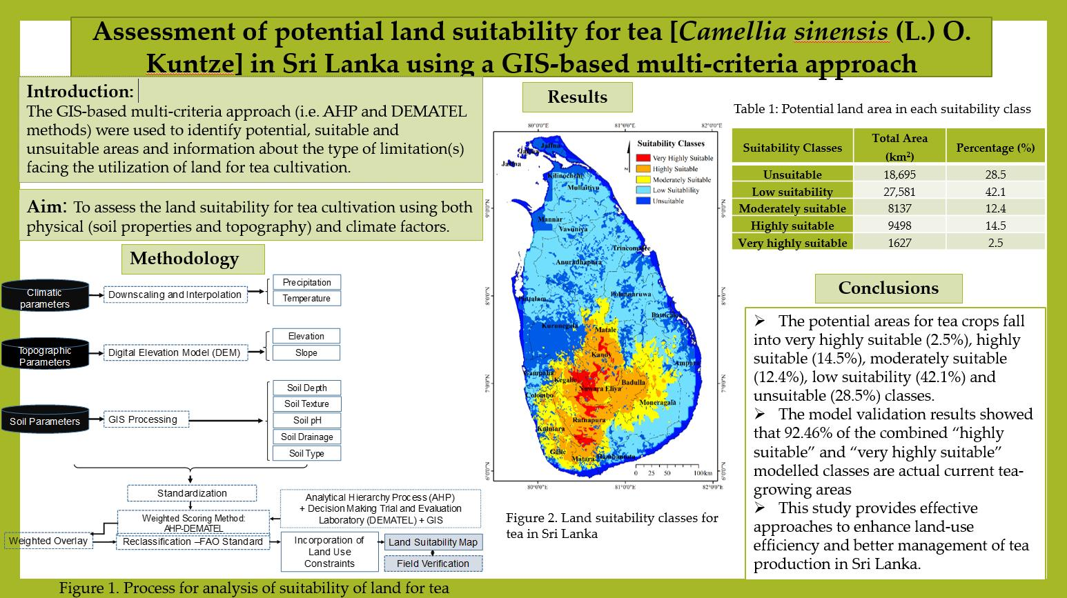
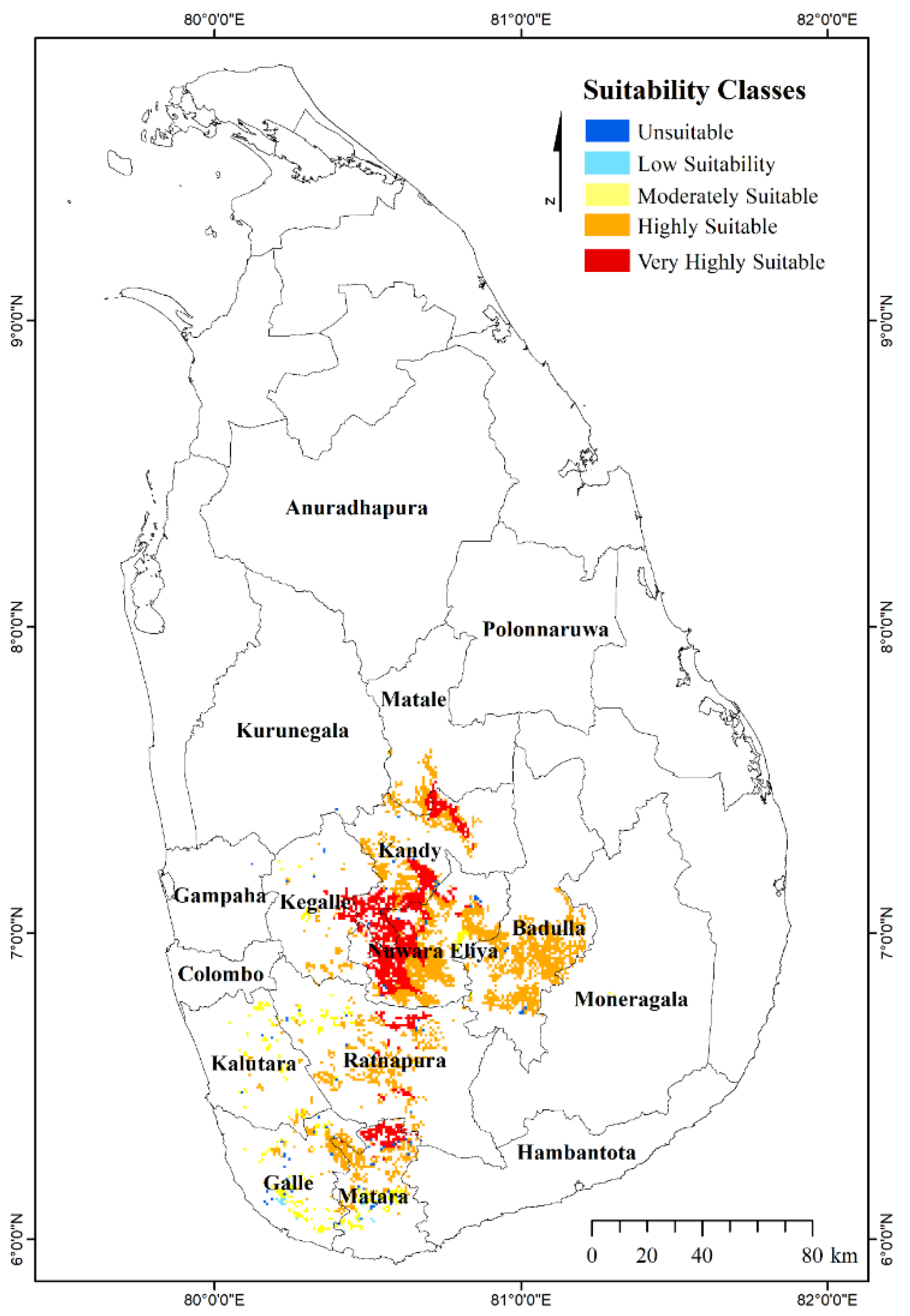
Despite some of the above limitations, the majority of existing tea-growing areas is classified into "very highly suitable "and "highly suitable” classes in the modelling, implying that the results are robust (
Figure 4). Therefore, our assessment of land suitability is considered to be sufficiently accurate as it aligns with the current tea-growing regions. In line with the results of previous research conducted by others [
26,
27,
81], this study shows that tea-growing areas are clustered in the central hills and SW quarter of Sri Lanka. Apparently the most suitable land masses for tea are clustered in Nuwara Eliya, Ratnapura, Matara, Galle, Matale, Kandy, Badulla, Kegalle and Kalutara districts. Soil types in these regions are mainly red yellow Podzolic which are suitable for the cultivation of tea crops, and soil textures are mainly sandy loam and loamy sand. If the environment is relatively stable and no natural disasters occur, these regions typically show a high yield of tea crops. Therefore, this type of region should be protected as a key tea ecological protection region and the suitability classes for tea will pave the way in determining policies for the optimal utilization of land in a sustainable manner for the future.
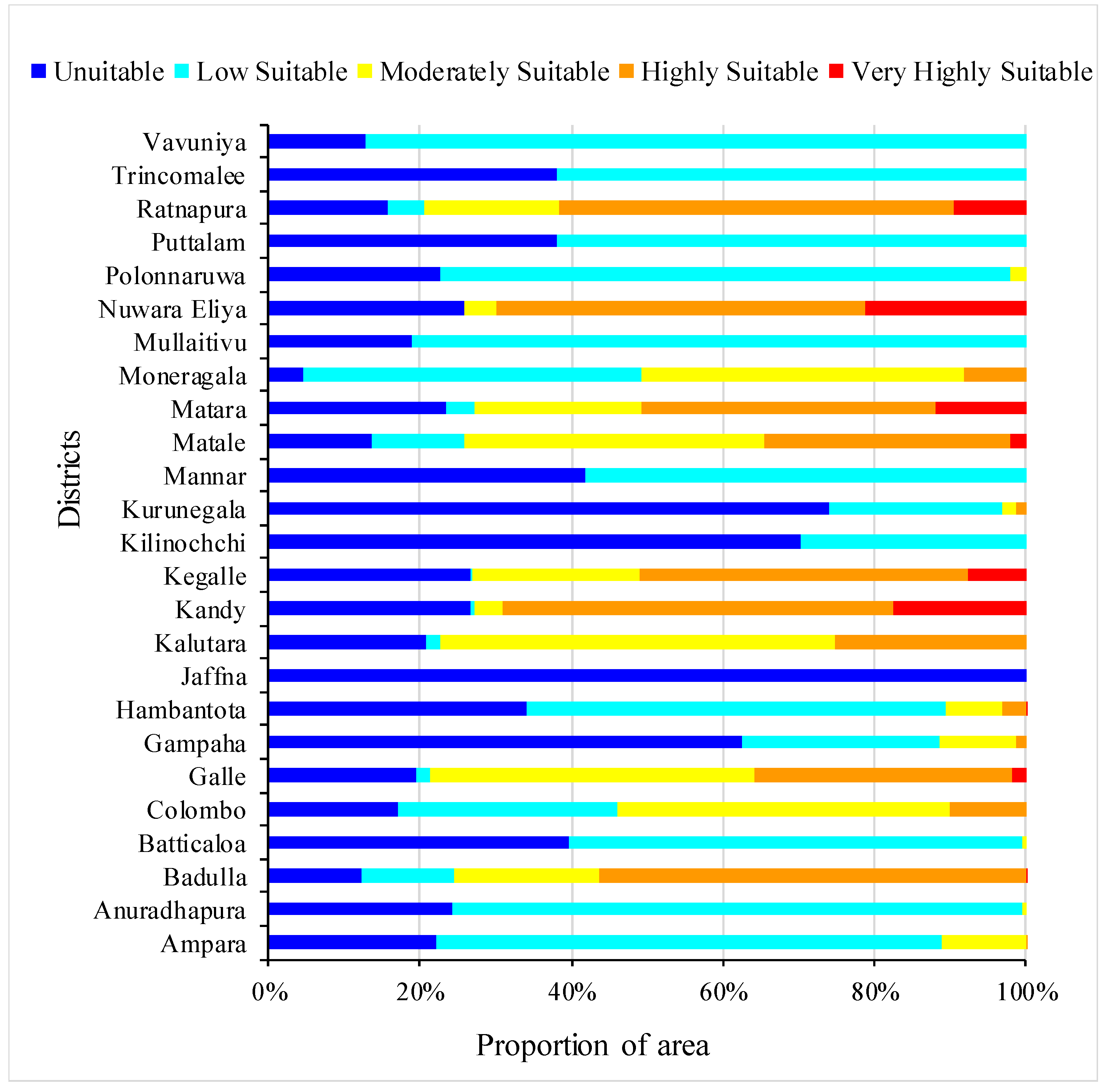
The analysis showed that the largest part of the land is occupied by a low suitability class, with 27,581 km
2 (42.1%), and an area of 18,695 km
2 (28.5%) has unsuitable land cover. An area of 8137 km
2 was moderately suitable and an area of 9498 km
2 was highly suitable for tea cultivation. The area of land that is very highly suitable for tea cultivation was 1627 km
2 (
Table 11). The highest proportion of “very highly suitable” areas in the Nuwara Eliya District, which is approximately 25 percent, indicates that climate, topographic and soil factors are desirable for tea cultivation in the Nuwara Eliya District. An area of approximately 477.5 km
2 (29.5%) of the very highly suitable class was recorded in the Kandy District, while Matara (465.1 km
2), Galle (508.1 km
2), Kegalle (820.6 km
2) and Ratnapura (1935.9 km
2) districts were also recorded as highly suitable tea-growing areas.
The coastal belt and the northern, western, eastern and north central regions are not suitable for tea cultivation (
Figure 4). It is known, for example, that considerable stretches of the coastal belt in the south western part of Sri Lanka (Galle, Matara, Kalutara and Colombo etc.) are partially or totally unsuitable for tea, not because of the climate, but mainly due to the poor soil types, namely grumosols, sandy regosols, non-calcic brown soils, etc. On the other hand, it is apparent that under suitable soil conditions, it is the climate and its temporal and spatial variations that delimit the possibilities and potential of agriculture in Sri Lanka [
81]. Although tea is not currently grown in some areas, they are found to be of moderate or low suitability (
Figure 4 and
Figure 5). This implies the possibility for future tea cultivation in these potential areas. In the Ampara, Moneragala and Kurunegala districts, for instance, there are moderately suitable areas where the cultivation can be expanded, despite the fact that they are not currently very renowned for tea cultivation.
A very small proportion of very highly suitable areas is reported in the Badulla district, which accounts for only 0.16%, although it is one of the major tea-growing areas in Sri Lanka [
11]. It can possibly be due to changing climatic conditions and other physical, chemical and soil-related biological limitations. The Kurunegala, Kegalle and Moneragala districts are known to contribute to tea production in Sri Lanka. The present study also shows that the Kurunegala, Kalutara, and Moneragala districts have "highly suitable" tea-growing areas, resulting in 1.35, 7.79, and 8.23% respectively.
Jaffna District is totally unsuitable for growing tea. The Kilinochchi District is also highly unsuitable for tea cultivation. Moreover, most other parts of Sri Lanka, such as the northern, central, north-western and eastern parts are shown as likely to be unsuitable as the topographical, climatic and soil factors are not favorable for tea cultivation, resulting in a higher proportion of "unsuitable" or "low suitable" categories (
Figure 5).
For Sri Lanka, in particular, climatic indices such as the ratio between rainfall and evaporation seems to be of great practical use for delimiting the potential growing areas of the tea plant. With regard to water balance, the potential tea-growing areas are limited roughly to the south-west quarter of Sri Lanka, including the Central Highlands [
81]. Interestingly, some parts of the Nuwara Eliya District are also unsuitable for tea production, as some lands are located on a much higher elevation, where the favorable environment for tea growth is limited. In particular, the upper limit of the highlands represents the boundaries of a warmth deficit as a result of temperature reduction with a higher altitude above sea level [
83]. This temperature deficit can have a severe impact on tea bushes by accelerating frost damage. Many parts of the highly grown tea fields (>1900 m) are heavily affected by "frost burning" and this may result in some areas of Nuwara Eliya being unsuitable for tea cultivation. Taking into account the specific slope requirements of the tea plants, the slope is highly correlated with sunshine hours.
According to the Tea Research Institute of Sri Lanka, the current main tea-growing areas are Nuwara Eliya, Ratnapura, Matara, and Kalawana [
84,
85], while the Galle and Kalutara districts and some parts of the Ratnapura, Kandy, and Matale districts are partly contributing to tea production [
85]. The results were verified by comparing the modelled suitability sites with the existing tea cultivation locations (
Figure 6 and
Table 12). If the majority of suitability classes exist in a region, it reflects the results in a logical and acceptable way, and then the findings become more viable [
78]. Correspondingly, the results of this study show that the existing tea-growing areas represent a higher percentage of “very highly” and “highly” suitable modelled classes, implying that our modelling was robust and the weightings that were used were appropriate. The high overlay in the very high and highly suitable class (92.46%) with existing tea-growing areas validates selection procedures of farmers and planters but also shows that the methodology used here is valid.
This study’s findings provide insights into recognizing those areas that are irreplaceable in terms of existing and future production and can therefore be used as a focus for more detailed planning. It is important for the tea sector to identify very highly and/or highly suitable land areas for tea as these areas can be used to further expand tea cultivation and to prevent it from being allocated for other non-agricultural purposes. An area of 685.8 km2 under the very highly suitable category is recorded in Ratnapura, Nuwara Eliya, Kegalle, and Matara districts that can potentially be brought into tea production in the future, while an area of 7261.7 km2 is also registered as a highly suitable area in the Moneragala, Kalutara and Matale districts and the other major existing tea-growing regions. In addition, the highly suitable potential lands can also be focused on for more detailed planning to help ensure sustainable tea production. Appropriate measures and resources should be properly placed in moderately suitable areas to maximize the land use for tea cultivation. This study allows the easy identification of low suitability and unsuitable tea lands, providing a sound impetus to utilize these lands for other management and development activities (i.e., construction, urban planning, ecosystem conservation, and agricultural purposes).
Furthermore, it is strategically important to understand the prevailing reality of the land suitability classes to tackle the socio-economic as well as environmental consequences of existing tea-based land use systems [
86]. The information provided in the maps (
Figure 4 and
Figure 5) can be used to identify more productive regions and tea lands for replanting, crop diversification, forestry and urban amenities, etc. Growers can also improve the suitability of available lands for tea crops by adopting appropriate agronomy measures relevant to the limitations indicated. A more detailed analysis for tea still requires more data, for example in terms of soil chemical properties and socio-economic factors. This study has provided information not only to the tea plantation sector and tea small holding sector, but also to the other investors planning for tea tourism. This helps stakeholders to easily identify the suitable blocks for tea cultivation and also the limiting factors, if any.


