Identifying Users’ Requirements for Emergency Mapping Team Operations in the Dominican Republic

 ,
, 
 ,
, 
Abstract
:1. Introduction
1.1. General Introduction (Including Research Questions and Objective)
1.2. Theoretical Overview
1.2.1. Users’ Requirements Identification
1.2.2. Spatial Data Infrastructure
1.2.3. Emergency Mapping Team
2. Dominican Republic in Context
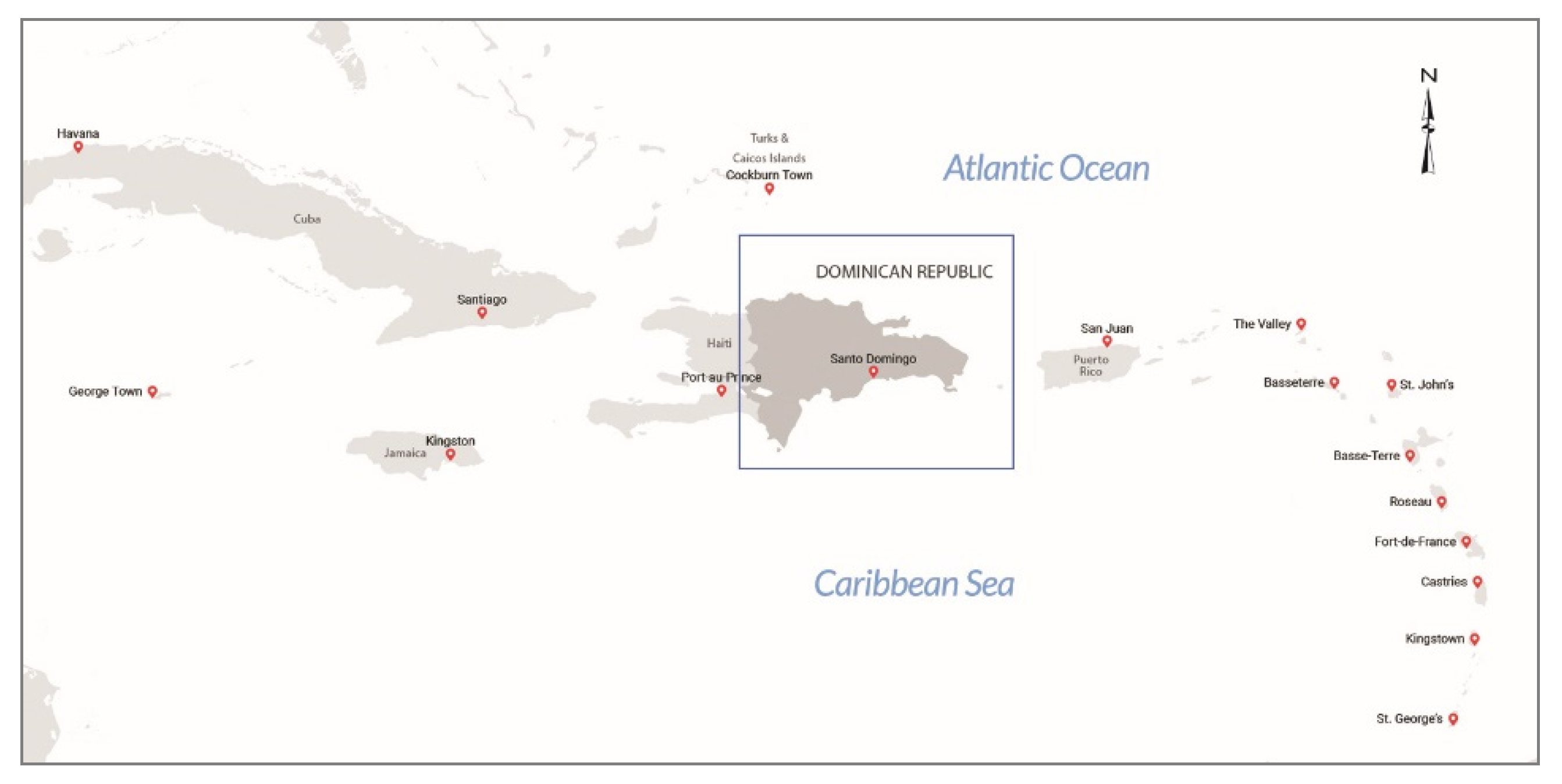
2.1. Geographical Setting
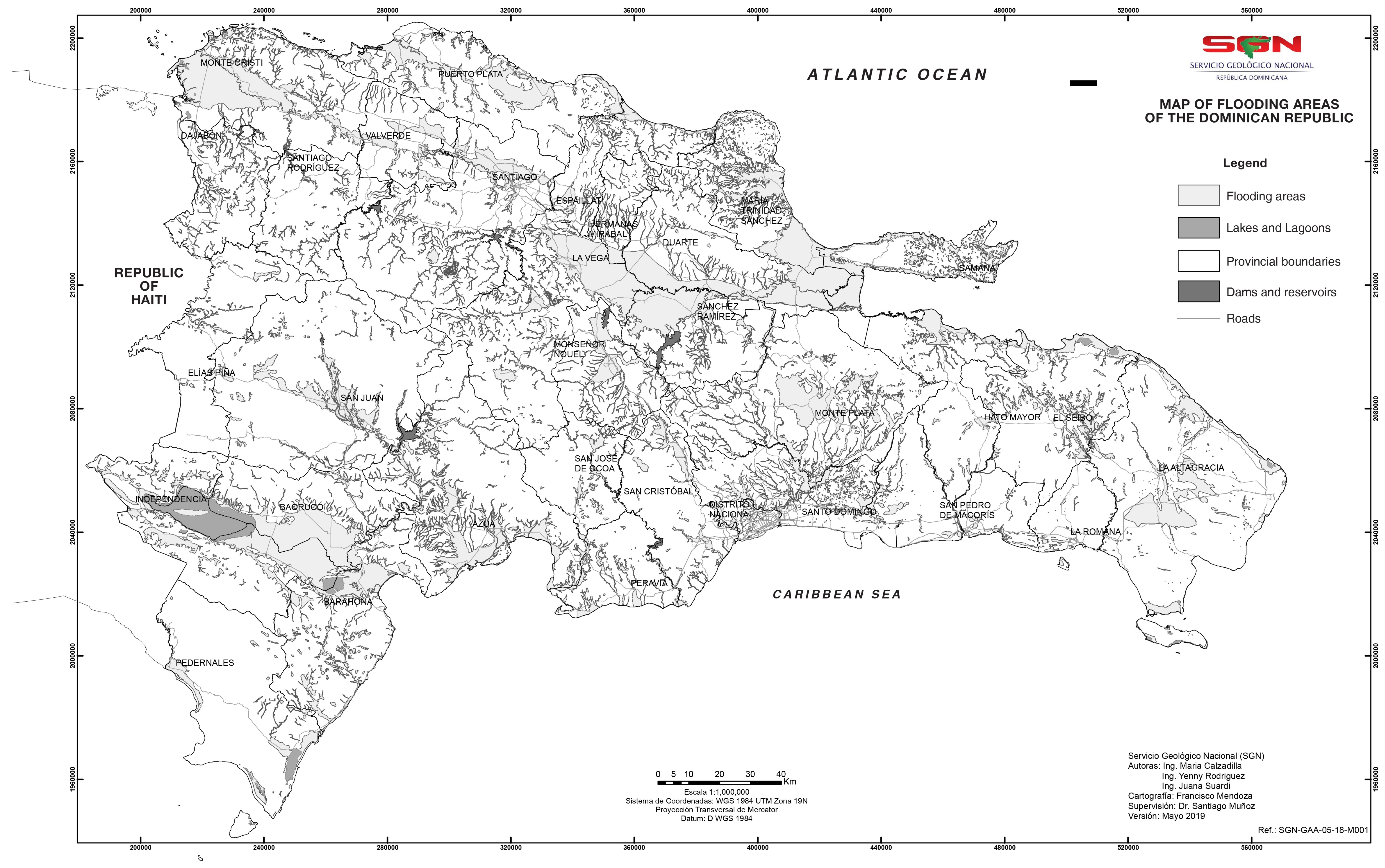
2.2. Natural Hazards Issues
2.3. Disaster Risk Reduction: Institutional and Legal Framework
2.4. Emergency Mapping Team in the Dominican Republic
3. Materials and Methods
4. Results and Discussion
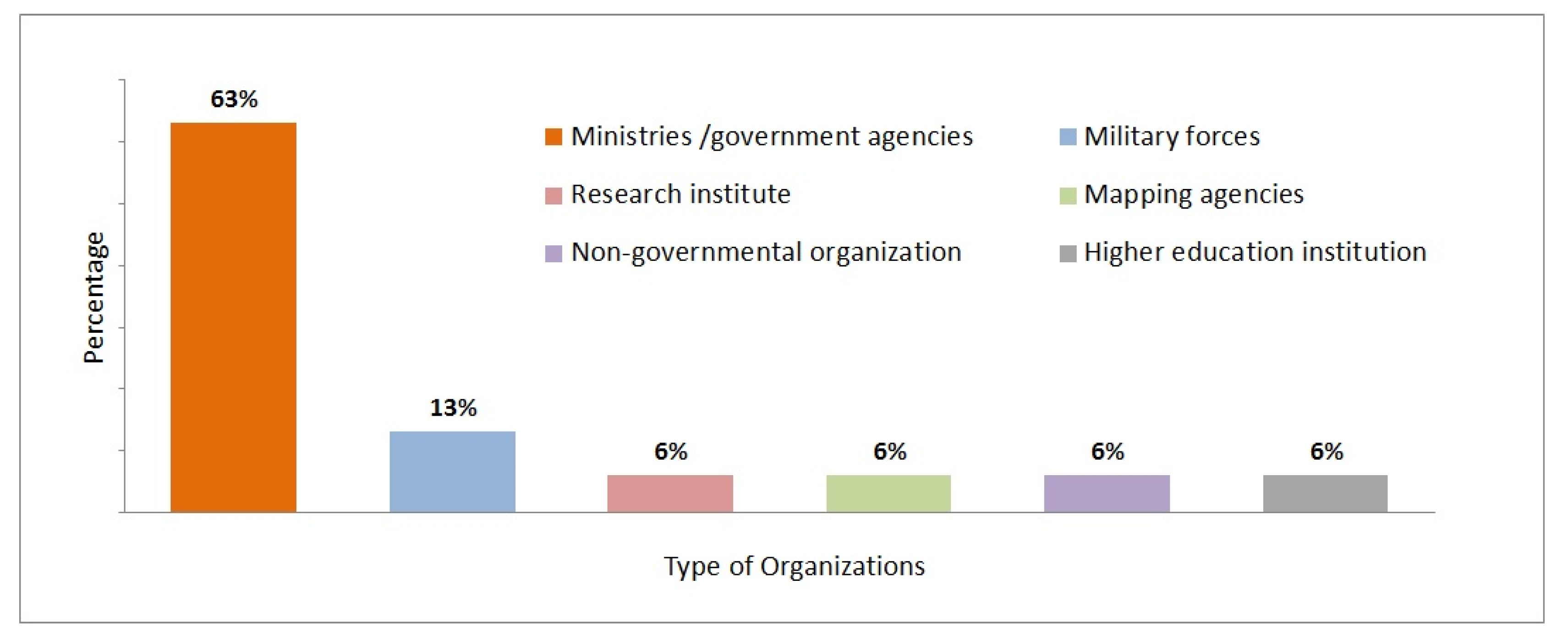
4.1. Survey Population
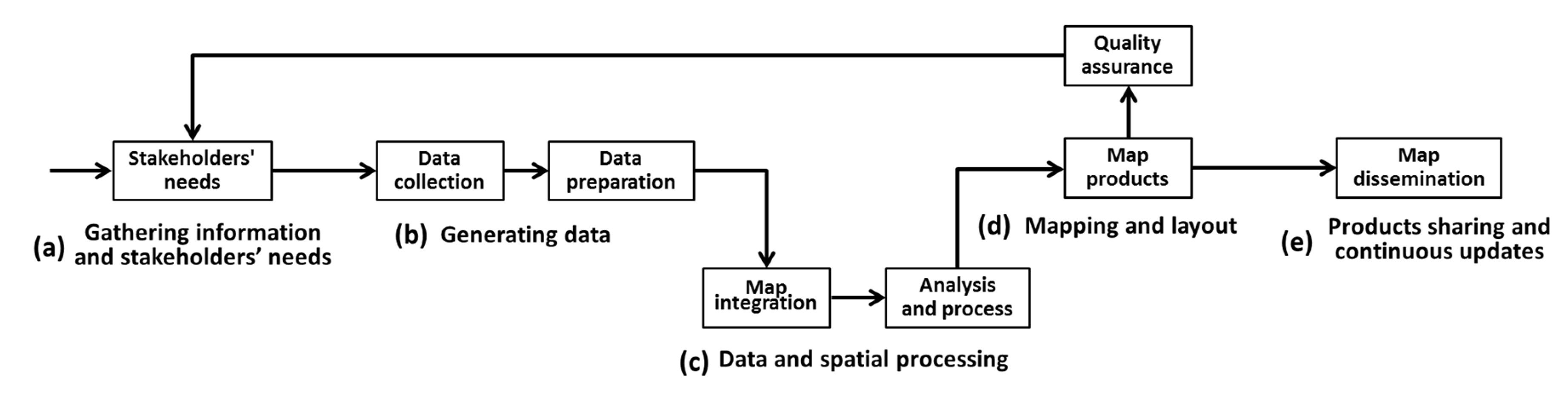
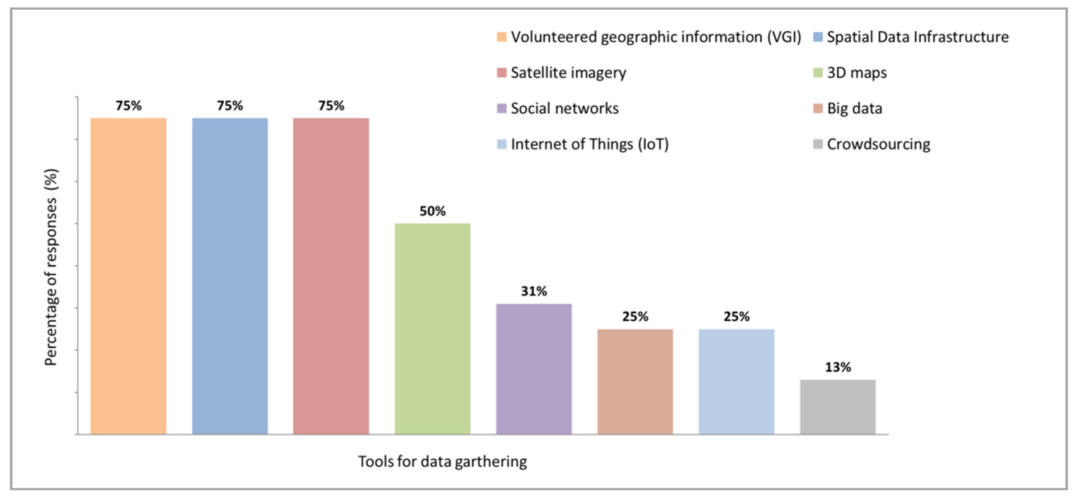
4.2. Gathering Information and Stakeholders’ Needs
4.3. Generating Data
4.4. Data and Geospatial Processing
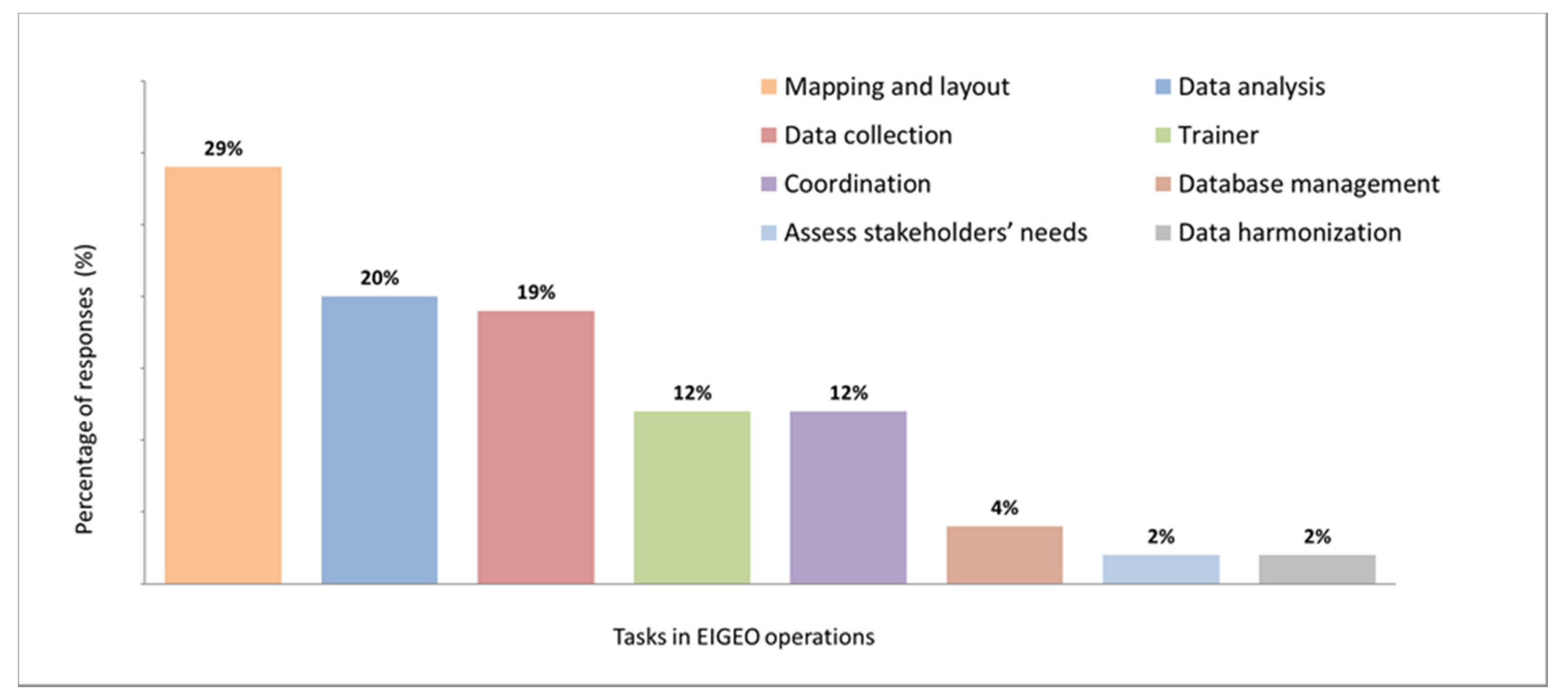
4.5. Mapping and Layout
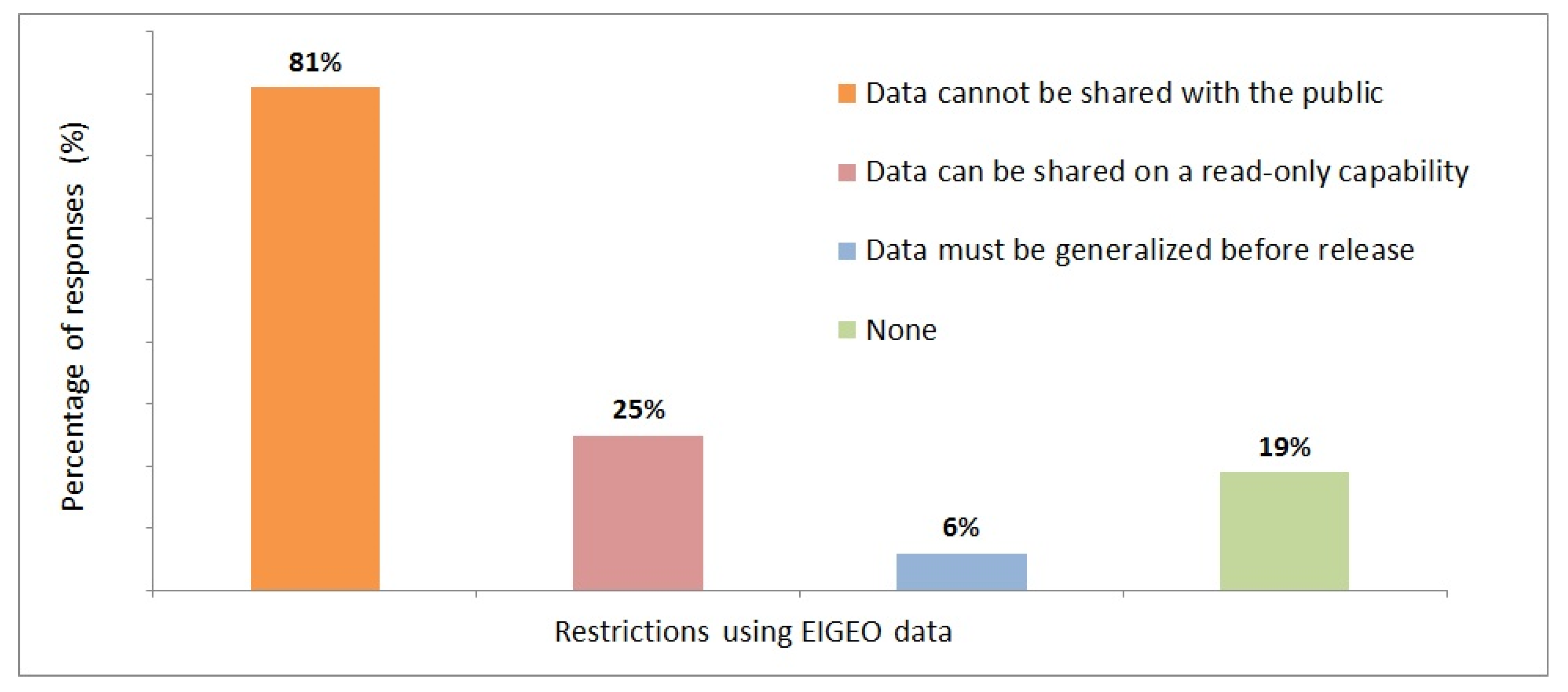
4.6. Products Sharing and Continuous Updates
5. Conclusions
- Standardization: standardization of data-capturing procedures, metadata, symbology, map products, services, and information workflow. This also includes technical guidance and specifications that help to save time while executing EMT operations;
- Establishing and maintaining a spatial data infrastructure: the SDI allows the integration, geo-processing, and visualization of disaster-related data in a distributed environment;
- Partnerships: partnership arrangements to connect with potential national and international stakeholders and to get more support from and interaction with local communities in the field;
- Effective communication among stakeholders: effective and timely communication to reach a clear understanding of other stakeholders’ needs and available resources to reduce redundancy of efforts;
- Capacity building: continuous capacity building initiatives to enable more internal and external skilled stakeholders to collaborate and take full advance of geospatial data integration and sharing for disaster responses in an efficient manner.
Author Contributions
Funding
Acknowledgments
Conflicts of Interest
References
- UNISDR. Sendai Framework for Disaster Risk Reduction 2015–2030; United Nations Office for Disaster Risk Reduction (UNISDR): Geneva, Switzerland, 2015. [Google Scholar]
- PreventionWeb. Dominican Republic Disaster & Risk Profile, United Nations Office for Disaster Risk Reduction, 2014. Available online: http://www.preventionweb.net/countries/dom/data (accessed on 16 July 2019).
- Kapucu, N. Interagency Communication Networks during Emergencies. Am. Rev. Public Adm. 2006, 36, 207–225. [Google Scholar] [CrossRef]
- Mansouriana, A.; Rajabifardb, A.; Zoeja, M.J.V. Sdi conceptual modeling for disaster management. In Proceedings of the Service and Application of Spatial Data Infrastructure, International Society for Photogrammetry and Remote Sensing, Hangzhou, China, 14–16 October 2005; pp. 125–130. [Google Scholar]
- Haworth, B.; Whittaker, J.; Bruce, E. Assessing the application and value of participatory mapping for community bushfire preparation. Appl. Geogr. 2016, 76, 115–127. [Google Scholar] [CrossRef]
- Johannes, T.W. Creating effective response communications. In Handbook of Emergency Response a Human Factors and Systems Engineering Approach; CRS Press: Boca Raton, FL, USA, 2013; pp. 595–608. [Google Scholar]
- Wolbers, J.; Boersma, K. The common operational picture as collective sensemaking. J. Contingencies Crisis Manag. 2013, 21, 186–199. [Google Scholar] [CrossRef]
- Keiko, T.; Hayashi, H. Geospatial Information Improves the Decision-Making Process during the Disaster Response: The Experience of the Emergency Mapping Team in the 2011 off the Pacific Coast of Tohoku Earthquake Takashi. In Proceedings of the 15th World Conference on Earthquake Engineering, Lisbon, Portugal, 24–28 September 2012. No. 5. [Google Scholar]
- Kimura, R.; Munenari, I.; Keiko, T.; Takashi, F.; Haruo, H. Clarifying the Function of the Emergency Mapping Team in order to Allocate the Limited Resources in the Time of 2011 Great East Japan Earthquake. In Proceedings of the TIEMS (The International Emergency Management Society), Tokyo, Japan, 22 May 2012; pp. 72–78. [Google Scholar]
- Kerle, N.; Hoffman, R.R. Collaborative damage mapping for emergency response: The role of Cognitive Systems Engineering. Nat. Hazards Earth Syst. Sci. 2013, 13, 97–113. [Google Scholar] [CrossRef] [Green Version]
- Diehl, S.; Neuvel, J.; Zlatanova, S.; Scholten, H. Investigation of user requirements in the emergency response sector: The Dutch case. In Proceedings of the Second Gi4DM, Goa, India, 25–26 September 2006; Volume 2000, pp. 25–26. [Google Scholar]
- Neuvel, J.M.M.; Scholten, H.J.; van den Brink, A. From Spatial Data to Synchronised Actions: The Network-centric Organisation of Spatial Decision Support for Risk and Emergency Management. Appl. Spat. Anal. Policy 2012, 5, 51–72. [Google Scholar] [CrossRef] [Green Version]
- Diehl, S.; van der Heide, J. Geo information breaks through sector think. In Geo-Information for Disaster Management; Springer: Berlin/Heidelberg, Germany, 2019; pp. 85–108. [Google Scholar] [CrossRef]
- Maguire, M.; Bevan, N. User requirements analysis: A review of supporting methods. In Proceedings of the IFIP 17th World Computer Congres, Montréal, QC, Canada, 25–30 August 2002; pp. 133–148. [Google Scholar]
- Soares, D.S.; Cioquetta, M.; Souza, D. Analysis of techniques for documenting user requirements. In Proceedings of the Computational Science and Its Applications—ICCSA 2012, Salvador de Bahia, Brazil, 18–21 June 2012; Volume 7336, pp. 16–28. [Google Scholar]
- De Leoni, M.; de Rosa, F.; Marrella, A.; Mecella, M.; Poggi, A. Emergency management: From user requirements to a flexible p2p architecture. In Proceedings of the 4th International ISCRAM Conference, Delft, The Netherlands, 13–16 May 2007; pp. 1–9. [Google Scholar]
- Crompvoets, J.; Bregt, A.; Rajabifard, A.; Williamson, I. Assessing the worldwide developments of national spatial data clearinghouses. Int. J. Geogr. Inf. Sci. 2004, 18, 665–689. [Google Scholar] [CrossRef]
- Fernández, T.D.; Crompvoets, J. Evaluating Spatial Data Infrastructures in the Caribbean for sustainable development. In Proceedings of the GSDI-10 Conference, Small Island Perspectives on Global Challenges: The Role of Spatial Data in Supporting a Sustainable Future, St. Ausustine, Trinidad, 25–29 February 2008; No. 313. p. 20. [Google Scholar]
- Masser, I.; Crompvoets, J. Building European Spatial Data Infrastructures, 3rd ed.; Esri Press: New York, NY, USA, 2015. [Google Scholar]
- Marasovic, S.; Crompvoets, J.; Hećimović, Ž.; Marasović, S.; Crompvoets, J. Development of local spatial data infrastructure in Croatia. J. Spat. Sci. 2014, 59, 221–234. [Google Scholar] [CrossRef]
- Nebert, D.D. The SDI Cookbook. GSDI, 2004; No. January. Available online: http://gsdiassociation.org/images/publications/cookbooks/SDI_Cookbook_GSDI_2004_ver2.pdf (accessed on 28 October 2018).
- Boccardo, P. New perspectives in emergency mapping. Eur. J. Remote Sens. 2013, 46, 571–582. [Google Scholar] [CrossRef] [Green Version]
- Ajmar, A.; Boccardo, P.; Disabato, F.; Tonolo, F.G. Rapid Mapping: Geomatics role and research opportunities. Rendiconti Lincei. Scienze Fisiche e Naturali 2015, 26, 63–73. [Google Scholar] [CrossRef] [Green Version]
- Gregorio, R.M.; Hong, J. A Spatial Data Infrastructure Perspective to Facilitate Emergency Mapping Team Operations; National Cheng Kong University: Tainan, Taiwan, 2013. [Google Scholar]
- Munenari, I.; Reo, K.; Keiko, T.; Haruo, H. Proposing Effective Method to Develop Common Operational Picture in Disaster Response Utilizing Cloud-based Geospatial Infrastructure. Int. J. Infonomics (IJI) 2012, 5, 663–668. [Google Scholar]
- Kevany, M. Geo-Information for Disaster Management: Lessons from 9/11. In Geo-Information for Disaster Management; Springer: Berlin/Heidelberg, Germany, 2005; pp. 443–464. [Google Scholar]
- Kevany, M. GIS in the World Trade Center response: 10 years after. ISPRS Int. Arch. Photogramm. Remote Sens. Spat. Inf. Sci. 2011, XXXVIII, 137–142. [Google Scholar] [CrossRef] [Green Version]
- Parker, C.; Stileman, M. Disaster Management: The Challenges for a National Geographic Information Provider. In Geo-information for Disaster Management; Springer: Berlin/Heidelberg, Germany, 2005; pp. 191–214. [Google Scholar]
- Brown, N. Jamaica s National Emergency GIS Team. In Proceedings of the United Nations International Expert Meeting on Crowdsource Mapping for Disaster Risk Management and Emergency Response. United Nations International Expert Meeting on Crowdsource Mapping for Disaster Risk Management and Emergency Response, Vienna, Austria, 3–5 December 2012; p. 47. [Google Scholar]
- EIGEO. Presentación Equipo Interinstitucional de Información Geoespacial. 2014. Available online: http://defensacivil.gob.do/index.php/eigeo (accessed on 13 June 2019).
- National Bureau of Statistic. IX Censo Nacional de Población y Vivienda 2010; National Bureau of Statistic: Santo Domingo, Dominican Republic, 2010.
- De Estadística, O.N. División Territorial; Oficina Nacional de Estadística (ONE): Santo Domingo, Dominican Republic, 2015.
- World Bank. Dominican Republic Overview. 2019. Available online: http://www.worldbank.org/en/country/dominicanrepublic/overview (accessed on 4 September 2019).
- National Geological Survey. Estudio de la Amenaza Sísmica y Vulnerabilidad Física del Gran Santo Domingo. Santo Domingo, Dominican Republic, 2015. Available online: http://sgn.gob.do/index.php/servicios/noticias/item/consultoria-especialista-en-norma-sismica-2 (accessed on 18 May 2019).
- UNFCCC. Vulnerability and Adaptation to Climate Change in Small Island Developing States; United Nations Framework Convention on Climate Change: New York, NY, USA, 2007; p. 38. [Google Scholar]
- CRED EM-DAT. The International Disaster Database. Centre for Research on the Epidemiology of Disasters (CRED), 2016. Available online: http://www.emdat.be/advanced_search/index.html (accessed on 4 April 2017).
- National Office of Meteorology. Comité Regional de Recursos Hidráulicos XLVIII Foro del Clima de America Central; National Office of Meteorology: Santo Domingo, Dominican Republic, 2015.
- National Geological Survey. Efecto de sitio a partir de la modelación 1D y 2D de suelos en el área urbana de Puerto Plata para la determinación de la vulnerabilidad en edificios esenciales. Santo Domingo, Dominican Republic, 2016. Available online: http://sgn.gob.do/images/docs/proyectos/vigentes/Proyectos_EFECTO_DE_SITIO_2016_1.pdf (accessed on 24 September 2019).
- National Congress. Ley No. 147-02 sobre Gestión de Riesgos; National Congress: Santo Domingo, Dominican Republic, 2002.
- Meyreles, L.; Ruíz, V. Revisión, Actualización y Análisis de Amenazas y Riesgos ante Desastres en República Dominicana; Departamento de Ayuda Humanitaria de la Comisión Europea. Oficia para el Caribe: Santo Domingo, Dominican Republic, 2011. [Google Scholar]
- MEPyD. Estrategia Nacional de Desarrollo 2030; Ministerio de Economía, Planificación y Desarrollo: Santo Domingo, Dominican Republic, 2012.
- Federal Geographic Data Committee—FGDC. Stages of the Geospatial Data Lifecycle Pursuant to OMB Circular A–16, Sections 8(e)(d), 8(e)(f), and 8(e)(g); Federal Geographic Data Committee (FGDC): Reston, VA, USA, 2010; Volume 8, No. d; pp. 1–23. [Google Scholar]
- Eide, A.W.; Haugstveit, I.M.; Halvorsrud, R.; Skjetne, J.H.; Stiso, M. Key challenges in multi-agency collaboration during large-scale emergency management. SINTEF Digit. Softw. Serv. Innov. 2012, 953, 39–46. [Google Scholar]
- Dusse, F.; Júnior, P.S.; Alves, A.T.; Novais, R.; Vieira, V.; Mendonça, M. Information visualization for emergency management: A systematic mapping study. Expert Syst. Appl. 2016, 45, 424–437. [Google Scholar] [CrossRef]
- Parsons, S.; Atkinson, P.M.; Simperl, E.; Weal, M. Thematically Analysing Social Network Content During Disasters through the Lens of the Disaster Management Lifecycle. Dml 2015, 1221–1226. Available online: https://eprints.soton.ac.uk/378754/1/swdm07-parsons.pdf (accessed on 24 September 2019).
- Eide, A.W.; Haugstveit, I.M.; Halvorsrud, R.; Borén, M. Inter-Organizational Collaboration Structures during Emergency Response: A Case Study. In Proceedings of the 10th International ISCRAM Conference, Baden-Baden, Germany, 12–15 May 2013; pp. 94–104. [Google Scholar]
- Carley, K.M.; Malik, M.; Landwehr, P.M.; Pfeffer, J.; Kowalchuck, M. Crowd sourcing disaster management: The complex nature of Twitter usage in Padang Indonesia. Saf. Sci. 2016, 90, 48–61. [Google Scholar] [CrossRef] [Green Version]
- Yates, D.; Paquette, S. Emergency knowledge management and social media technologies: A case study of the 2010 Haitian earthquake. Int. J. Inf. Manag. 2011, 31, 6–13. [Google Scholar] [CrossRef]
- Genovese, E.; Stéphane, R. Potential of VGI as a Resource for SDIs in the North/South Context. Geomatica 2010, 64, 439–450. [Google Scholar]
- McDougall, K. An Assessment of the Contribution of Volunteered Geographic Information during Recent Natural Disasters. In Spatially Enabling Government, Industry and Citizens: Research and Development Perspectives; Rajabifardb, A., Colleman, D., Eds.; GSDI Association Press: Needham, MA, USA, 2012; pp. 201–2014. [Google Scholar]
- Bharosa, N.; Lee, J.; Janssen, M. Challenges and obstacles in sharing and coordinating information during multi-agency disaster response: Propositions from field exercises. Inf. Syst. Front. 2010, 12, 49–65. [Google Scholar] [CrossRef] [Green Version]
- Eelderink, L.; Crompvoets, J.; de Man, W.H.E. Towards key variables to assess National Spatial Data Infrastructures (NSDIs) in developing countries. In A Multi-View Framework to Assess SDIs; The Melbourne University Press: Melbourne, Australia, 2008; pp. 307–325. [Google Scholar]
- Vandenbroucke, D.; Crompvoets, J.; Vancauwenberghe, G.; Dessers, E.; van Orshoven, J. A network perspective on spatial data infrastructures: Application to the sub-national SDI of Flanders (Belgium). Trans. GIS 2009, 13, 105–122. [Google Scholar] [CrossRef]
- Steudler, D.; Rajabifard, A.; Williamson, I. Evaluation and Performance Indicators to Assess Spatial Data Infrastructure Initiatives. In Multi-View Framework to Assess Spatial Data Infrastructures; Crompvoets, J., Rajabifard, A., van Loenen, B., Delgado, T., Eds.; Wageningen University: Wageningen, The Netherlands; University of Melbourne: Melbourne, Australia, 2008; pp. 193–210. [Google Scholar]
- De Gier, A.; Westinga, E.; Beerens, S.; van Laake, P.; Savenije, H. User Requirements Study for Remote Sensing-Based Spatial Information the Sustainable Management of Forests; ITC-BPC: Enschede, The Netherlands, 1999. [Google Scholar]
- Vratonjić, M.; Wittmann, H. Using and Optimising GIS in an Emergency Response; European Emergency Number Association: Brussels, Belgium, 2015; pp. 13–14. [Google Scholar]
- Box, P. The Governance of Spatial Data Infrastructure: A Registry Based Model; The University of Melbourne: Melbourne, Australia, 2013; No. April. [Google Scholar]
- Mcdougall, K.; Rajabifard, A.; Williamson, I. A mixed-method approach for evaluating spatial data sharing partnerships for spatial data infrastructure development. Res. Theory Adv. Spat. Data Infrastruct. Concepts 2007, 5, 55–73. [Google Scholar]
- ISACA. A Business Framework for the Governance and Management of Enterprise IT; ISACA: Rolling Meadows, IL, USA, 2013. [Google Scholar]


| Necessity of EIGEO Stakeholders | Detailed Mentioned Responses |
|---|---|
| Tools for data collection |
|
| Standardized data |
|
| Communities support |
|
| Capacity building |
|
| Recommended Actions for Gathering Information and Stakeholders’ Needs | Detailed Mentioned Responses |
|---|---|
| Effective Communication |
|
| Standardization |
|
| Automatization of information gathering processes |
|
| Training |
|
| Coordination |
|
| Actions for Improving EIGEO Data Generation | Detailed Mentioned Responses |
|---|---|
| Standardization |
|
| Human resources and capacity building |
|
| Geospatial data |
|
| Coordination |
|
| EIGEO Data Processing Tasks | No Response | Not Relevant | Moderately Relevant | Relevant | Extremely Relevant |
|---|---|---|---|---|---|
| Conversion of data formats | 6% | - | - | 31% | 63% |
| Transformation of coordinate systems | 6% | - | - | 25% | 69% |
| Adding necessary attribute fields | 6% | - | - | 50% | 44% |
| Fixing topological errors | - | 6% | 50% | 44% | |
| Modifying database schemas | 6% | 6% | 13% | 44% | 31% |
| Completing missing features | - | - | - | 56% | 44% |
| Updating old data | - | - | - | 25% | 75% |
| Digitizing paper-based maps | 6% | 19% | 19% | 38% | 19% |
| Geo-referencing | 6% | - | - | 31% | 63% |
| Actions for Improving Geospatial and Data Processing | Detailed Mentioned Responses |
|---|---|
| Distributed processing |
|
| Spatial data infrastructure |
|
| Standardization |
|
| Capacity building |
|
| EIGEO Maps | No Response | Never | Rarely | Sometimes | Always |
|---|---|---|---|---|---|
| Road map | 12% | 19% | 19% | 25% | 25% |
| Shelters map | 12% | 12% | 19% | 25% | 32% |
| Temporary health centers map | 12% | 19% | 19% | 44% | 6% |
| Critical infrastructures map | 12% | 19% | 19% | 44% | 6% |
| Operations map | 12% | 12% | 25% | 38% | 13% |
| Blank map | 12% | 50% | 38% | - | - |
| Buildings map | 19% | 19% | 25% | 31% | 6% |
| Recommended Actions for Mapping and Layout | Detailed Responses |
|---|---|
| Standardization | Emergency symbology, map template, automotive processes and geospatial information platform |
| Technical capabilities | Strengthen the hardware infrastructure and technical trainings |
| Geospatial information | Continuous access to base data and real-time post-disaster information |
| Local level capabilities | Enhance the involvement and capabilities of the local authorities on the emergency mapping operations |
| Web Services for EMT Operations | No Response | Not Relevant | Moderately Relevant | Relevant | Extremely Relevant |
|---|---|---|---|---|---|
| Web Map Service (WMS) | 6% | - | 6% | 25% | 63% |
| Web Feature Service (WFS) | 6% | - | 6% | 38% | 50% |
| Web Coverage Service (WCS) | 12% | - | 12% | 38% | 38% |
| Web Catalogue Service (CSW) | 13% | - | - | 56% | 31% |
| Web Coverage Processing Service (WCPS) | 12% | - | 19% | 38% | 31% |
| Web Processing Service (WPS) | 13% | - | 6% | 56% | 25% |
| Web Map Tile Service (WMTS) | 19% | - | 19% | 43% | 19% |
| Recommended Actions for Products Sharing and Continuous Updates | Detailed Responses |
|---|---|
| Spatial data infrastructure | Develop a national SDI for disaster risk management Open data approach Easy data access to users |
| Knowledge management | Enhance knowledge sharing in two ways, by increasing knowledge reuse within EIGEO members from each mapping operations and by brainstorming new ideas for developing required tools |
| Participatory mapping | Involving local users through two-way communication channels to provide more up-to-date, reliable and locally relevant information |
© 2020 by the authors. Licensee MDPI, Basel, Switzerland. This article is an open access article distributed under the terms and conditions of the Creative Commons Attribution (CC BY) license (http://creativecommons.org/licenses/by/4.0/).
Share and Cite
Rosario Michel, G.; Muñoz Tapia, S.; Manzano Aybar, F.; Guzmán Javier, V.; Crompvoets, J. Identifying Users’ Requirements for Emergency Mapping Team Operations in the Dominican Republic. ISPRS Int. J. Geo-Inf. 2020, 9, 165. https://doi.org/10.3390/ijgi9030165
Rosario Michel G, Muñoz Tapia S, Manzano Aybar F, Guzmán Javier V, Crompvoets J. Identifying Users’ Requirements for Emergency Mapping Team Operations in the Dominican Republic. ISPRS International Journal of Geo-Information. 2020; 9(3):165. https://doi.org/10.3390/ijgi9030165
Chicago/Turabian StyleRosario Michel, Gregorio, Santiago Muñoz Tapia, Fernando Manzano Aybar, Vladimir Guzmán Javier, and Joep Crompvoets. 2020. "Identifying Users’ Requirements for Emergency Mapping Team Operations in the Dominican Republic" ISPRS International Journal of Geo-Information 9, no. 3: 165. https://doi.org/10.3390/ijgi9030165
APA StyleRosario Michel, G., Muñoz Tapia, S., Manzano Aybar, F., Guzmán Javier, V., & Crompvoets, J. (2020). Identifying Users’ Requirements for Emergency Mapping Team Operations in the Dominican Republic. ISPRS International Journal of Geo-Information, 9(3), 165. https://doi.org/10.3390/ijgi9030165