
FastFix Albatross Data: Snapshots of Raw GPS L-1 Data from Southern Royal Albatross


Abstract
:1. Summary
2. Data Description
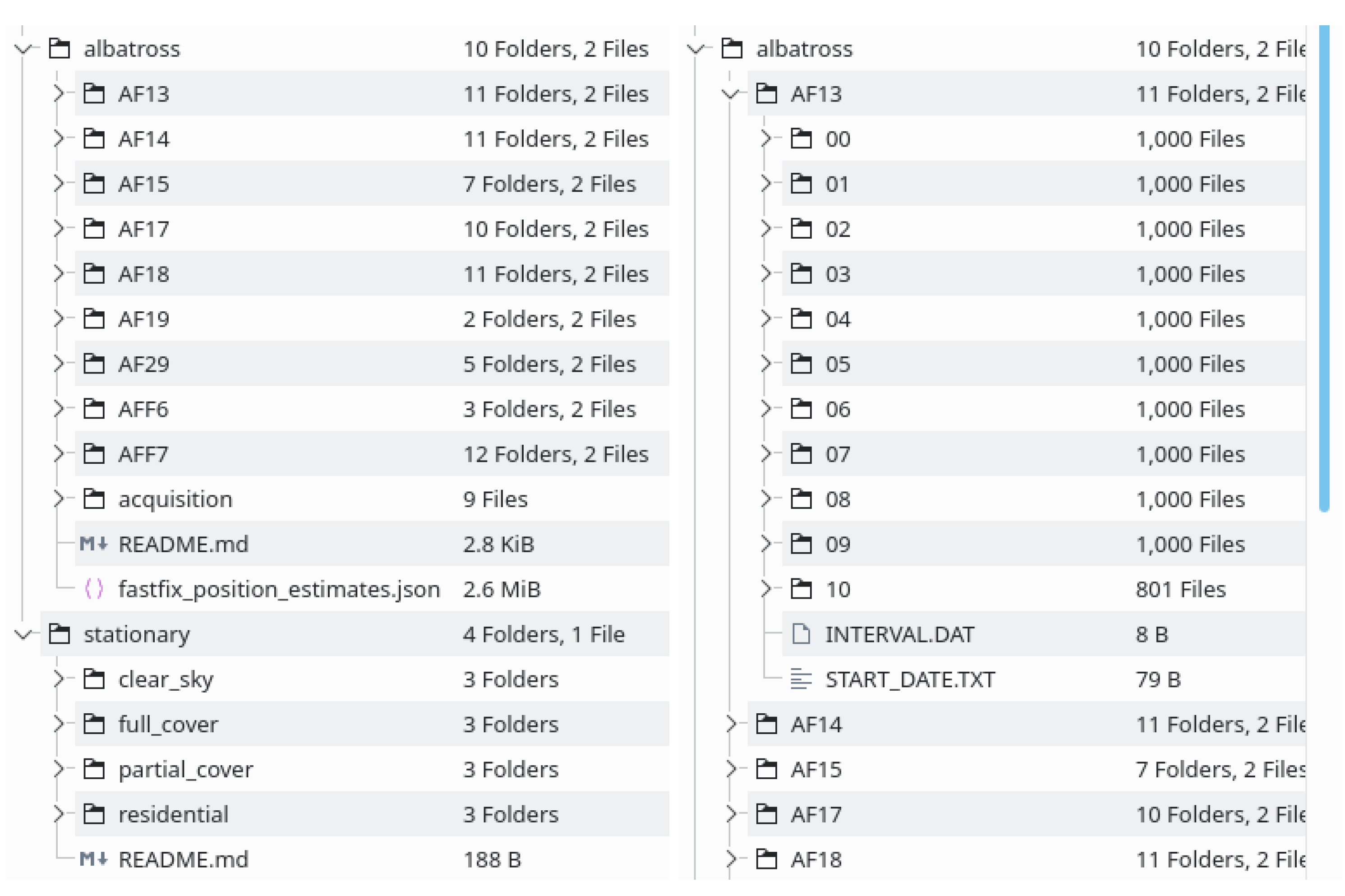
2.1. Directory Structure
2.2. Tag Data Directory Structure

2.3. Snapshot File Structure
          uint32_t calculate_checksum(struct fix* f) {
            uint32_t i;
            uint32_t word_count = f->sample_bytes / 2;

            uint32_t ret = 0;
            for (i=0;i<word_count;i+=2) {
              ret += f->buffer[i];
            }
            return ret.
          }
2.4. Stationary Test Data
2.5. Acquisition Data

3. Methods
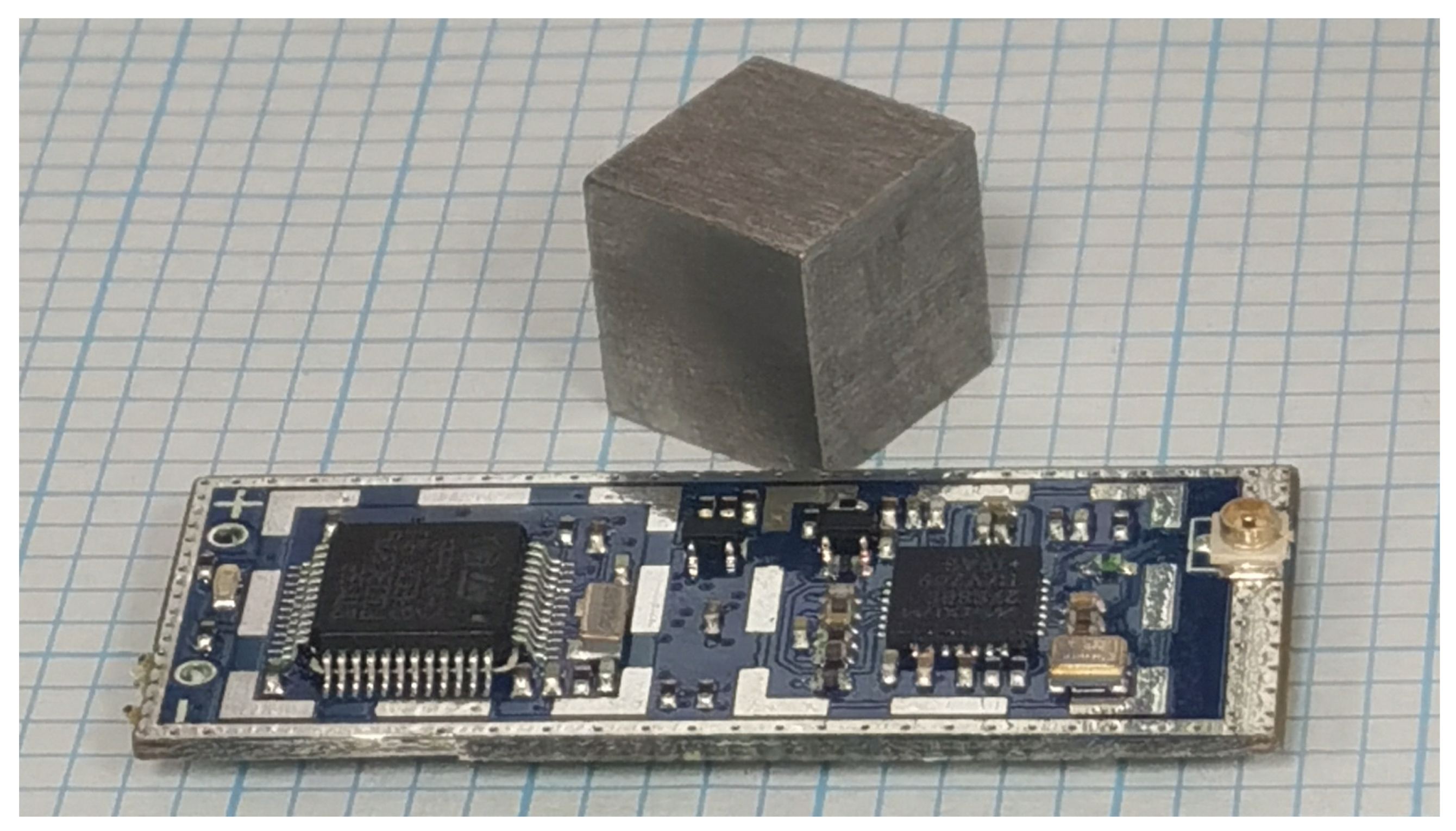
3.1. Tag Electronics
3.2. FastFix Position Estimates
4. Discussion & Conclusions
Author Contributions
Funding
Institutional Review Board Statement
Data Availability Statement
Acknowledgments
Conflicts of Interest
References
- Peterson, B.; Hartnett, R.; Ottman, G. GPS receiver structures for the urban canyon. In Proceedings of the 8th International Technical Meeting of the Satellite Division of the Institute of Navigation (ION GPS 1995), Palm Springs, CA, USA, 12–15 September 1995; pp. 1323–1332. [Google Scholar]
- Akopian, D.; Syrjarinne, J. A fast positioning method without navigation data decoding for assisted GPS receivers. IEEE Trans. Veh. Technol. 2009, 58, 4640–4645. [Google Scholar] [CrossRef]
- Molteno, T.C.A. An Apparatus and Method for Determining a Position of an Object. Provisional Patent Application No. WO2011046455A1, 21 April 2011. [Google Scholar]
- Molteno, T.C.A. Estimating Position from Millisecond Samples of GPS Signals (the “FastFix” Algorithm). Sensors 2020, 20, 6480. [Google Scholar] [CrossRef] [PubMed]
- Othieno, N.; Gleason, S. Combined Doppler and time free positioning technique for low dynamics receivers. In Proceedings of the 2012 IEEE/ION Position, Location and Navigation Symposium, Myrtle Beach, SC, USA, 23–26 April 2012; IEEE: Piscataway, NJ, USA, 2012; pp. 60–65. [Google Scholar]
- Payne, K.W. Development of Two New GPS Avian Tracking Systems. Ph.D. Thesis, University of Otago, Dunedin, New Zealand, 2015. [Google Scholar]
- Sugishita, J. Provisioning and Foraging Strategies of Northern Royal Albatross (Diomedea Sanfordi) at Taiaroa Head/Pukekura, and Relationship with Fisheries. Ph.D. Thesis, University of Otago, Dunedin, New Zealand, 2016. [Google Scholar]
- Maxim Integrated Products. MAX2769B Universal GPS Receiver, rev 1st ed.; Maxim Integrated Products: Sunnyvale, CA, USA, 2011. [Google Scholar]
- ST Microelectronics NV. Medium-Density Performance line ARM®-Based 32-bit MCU with 64 or 128 KB Flash, USB, CAN, 7 Timers, 2 ADCs, 9 com. Interfaces, DocID13587 Rev 17 ed. 2015. Available online: www.st.com (accessed on 12 February 2021).
- Taoglas, Enniscorthy, Co. 12mm Two Stage 25dB GPS/GALILEO Active Patch Antenna Module with Front-End Saw Filter, spe-11-8-094/e/ss ed; Taoglas, Enniscorthy, Co.: Wexford, Ireland, 2009. [Google Scholar]
| 1 | Some tags stored data, but suspected antenna malfunctions meant no satellite data were present. These tags are not included in the dataset. |


| Tag Name | Snapshot Count | Start Time (UTC) |
|---|---|---|
| AFF6 | 1888 | 2012-02-21T20:50:00 |
| AF13 | 10,801 | 2012-02-21T20:52:40 |
| AF14 | 11,054 | 2012-02-21T20:59:50 |
| AF15 | 6078 | 2012-02-22T03:17:30 |
| AF17 | 10,814 | 2012-02-29T22:01:30 |
| AF18 | 10,060 | 2012-02-29T22:07:15 |
| AF19 | 1701 | 2012-02-29T22:11:05 |
| AF29 | 4135 | 2013-01-10T19:45:53 |
| AF31 | 3337 | 2013-02-14T23:01:00 |
| Bytes Address | Variable Name | Description |
|---|---|---|
| rtc_counter_value | Offset in seconds since the start time | |
| sample_count | Number of samples in this snapshot | |
| sample_bytes | Number of bytes in this snapshot | |
| sample_ms | Snapshot duration in milliseconds | |
| sampling_rate | Sampling rate | |
| checksum | A checksum for validating that data. | |
| data | Interleaved 1-bit I/Q binary baseband data. |
| Scenario | Latitude | Longitude | Altitude (m) |
|---|---|---|---|
| roof_tests | −45.863912 | 170.51348452 | 46.5 |
| Clear Sky | −44.010808 | 170.489961 | 765 |
| Full Forest Cover | −44.006406 | 170.498767 | 768 |
| Partial Forest Cover | −44.005086 | 170.498037 | 766 |
| Residential | −44.010808 | 170.489125 | 770 |
| i | SV | Doppler-Sift | Code-Phase | |
|---|---|---|---|---|
| 1 | 16 | 30.01 | +2185.15461 | 0.503051794 |
| 2 | 23 | 21.08 | +1632.13669 | 0.576269412 |
| 3 | 32 | 16.84 | −2624.85478 | 0.209007485 |
| 4 | 13 | 14.03 | +2335.25122 | 0.197458456 |
| 5 | 20 | 13.56 | −818.94480 | 0.344973267 |
| 6 | 4 | 10.70 | −155.43040 | 0.439863498 |
Publisher’s Note: MDPI stays neutral with regard to jurisdictional claims in published maps and institutional affiliations. |
© 2021 by the authors. Licensee MDPI, Basel, Switzerland. This article is an open access article distributed under the terms and conditions of the Creative Commons Attribution (CC BY) license (https://creativecommons.org/licenses/by/4.0/).
Share and Cite
Molteno, T.C.A.; Payne, K.W. FastFix Albatross Data: Snapshots of Raw GPS L-1 Data from Southern Royal Albatross. Data 2021, 6, 37. https://doi.org/10.3390/data6040037
Molteno TCA, Payne KW. FastFix Albatross Data: Snapshots of Raw GPS L-1 Data from Southern Royal Albatross. Data. 2021; 6(4):37. https://doi.org/10.3390/data6040037
Chicago/Turabian StyleMolteno, Timothy C. A., and Keith W. Payne. 2021. "FastFix Albatross Data: Snapshots of Raw GPS L-1 Data from Southern Royal Albatross" Data 6, no. 4: 37. https://doi.org/10.3390/data6040037
APA StyleMolteno, T. C. A., & Payne, K. W. (2021). FastFix Albatross Data: Snapshots of Raw GPS L-1 Data from Southern Royal Albatross. Data, 6(4), 37. https://doi.org/10.3390/data6040037