Modern Geophysical and Climate Data Analysis: Tools and Methods

A topical collection in Data (ISSN 2306-5729). This collection belongs to the section "Spatial Data Science and Digital Earth".

Viewed by 5566

Editors


E-Mail Website
Guest Editor

E-Mail Website
Guest Editor
Institute of Physics Belgrade, University of Belgrade, 11080 Belgrade, Serbia
Interests: statistical modeling in atmospheric physics; multivariate receptor modeling; ground-based remote sensing for retrieval of the atmospheric composition; aerosol optical properties; aerosol physical and chemical characterization and climatic role; air quality
Special Issues, Collections and Topics in MDPI journals

Topical Collection Information

Dear Colleagues,

The expansion and scope of geophysical and climate data, with associated analytical tools and approaches, are changing rapidly day after day as we move into the future. The rise of “Big Data” sets deepens our understanding of such complex structured and unstructured data. In the relatively recent past of the last few decades, these datasets were relatively small and frequently disregarded by statisticians as biased data. With the availability of large geophysical and climate datasets, i.e., “Big Data”, the scientific community (statisticians, computer scientists, geophysicists, etc.) was forced to develop analytically rigorous methods in order to deal with such vast datasets. To evaluate data patterns, variable relationships, and prediction, various methods have been created, followed by emerging appropriate novel statistical theories.  

This topic seeks to offer a forum for in-depth discussion and contributions that can have either an applied or theoretical perspective and highlight different problems, with special emphasis on data analytics and methods. Manuscripts summarizing the most recent state of the art on these topics are welcome. The topics to be covered include but are not limited to the following: cutting-edge statistical learning tools for the analysis of geophysical and climate data; cutting-edge machine learning tools for the analysis of geophysical and climate data; innovative applications of existing statistical learning and/or machine learning tools for geophysical and climate data.

Prof. Dr. Vladimir Sreckovic
Dr. Zoran Mijic
Guest Editors

Manuscript Submission Information

Manuscripts should be submitted online at www.mdpi.com by registering and logging in to this website. Once you are registered, click here to go to the submission form. Manuscripts can be submitted until the deadline. All submissions that pass pre-check are peer-reviewed. Accepted papers will be published continuously in the journal (as soon as accepted) and will be listed together on the collection website. Research articles, review articles as well as short communications are invited. For planned papers, a title and short abstract (about 100 words) can be sent to the Editorial Office for announcement on this website.

Submitted manuscripts should not have been published previously, nor be under consideration for publication elsewhere (except conference proceedings papers). All manuscripts are thoroughly refereed through a single-blind peer-review process. A guide for authors and other relevant information for submission of manuscripts is available on the Instructions for Authors page. Data is an international peer-reviewed open access monthly journal published by MDPI.

Please visit the Instructions for Authors page before submitting a manuscript. The Article Processing Charge (APC) for publication in this open access journal is 1600 CHF (Swiss Francs). Submitted papers should be well formatted and use good English. Authors may use MDPI's English editing service prior to publication or during author revisions.

Keywords

  • data in geo and climate and related fields
  • analysis and prediction
  • new applications
  • algorithms
  • machine learning
  • visualization

Published Papers (2 papers)

2023

6 pages, 2139 KiB  
Data Descriptor
Long-Term Spatiotemporal Oceanographic Data from the Northeast Pacific Ocean: 1980–2022 Reconstruction Based on the Korea Oceanographic Data Center (KODC) Dataset
by Seong-Hyeon Kim and Hansoo Kim
Data 2023, 8(12), 175; https://doi.org/10.3390/data8120175 - 23 Nov 2023
Viewed by 1613
Abstract
The Korea Oceanographic Data Center (KODC), overseen by the National Institute of Fisheries Science (NIFS), is a pivotal hub for collecting, processing, and disseminating marine science data. By digitizing and subjecting observational data to rigorous quality control, the KODC ensures accurate information in [...] Read more.
The Korea Oceanographic Data Center (KODC), overseen by the National Institute of Fisheries Science (NIFS), is a pivotal hub for collecting, processing, and disseminating marine science data. By digitizing and subjecting observational data to rigorous quality control, the KODC ensures accurate information in line with international standards. The center actively engages in global partnerships and fosters marine data exchange. A wide array of marine information is provided through the KODC website, including observational metadata, coastal oceanographic data, real-time buoy records, and fishery environmental data. Coastal oceanographic observational data from 207 stations across various sea regions have been collected biannually since 1961. This dataset covers 14 standard water depths; includes essential parameters, such as temperature, salinity, nutrients, and pH; serves as the foundation for news, reports, and analyses by the NIFS; and is widely employed to study seasonal and regional marine variations, with researchers supplementing the limited data for comprehensive insights. The dataset offers information for each water depth at a 1 m interval over 1980–2022, facilitating research across disciplines. Data processing, including interpolation and quality control, is based on MATLAB. These data are classified by region and accessible online; hence, researchers can easily explore spatiotemporal trends in marine environments. Full article
Show Figures

Figure 1

12 pages, 3179 KiB  
Data Descriptor
Reconstructed River Water Temperature Dataset for Western Canada 1980–2018
by Rajesh R. Shrestha and Jennifer C. Pesklevits
Data 2023, 8(3), 48; https://doi.org/10.3390/data8030048 - 26 Feb 2023
Cited by 3 | Viewed by 2729
Abstract
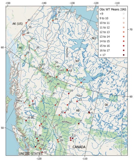
Continuous water temperature data are important for understanding historical variability and trends of river thermal regime, as well as impacts of warming climate on aquatic ecosystem health. We describe a reconstructed daily water temperature dataset that supplements sparse historical observations for 55 river [...] Read more.
Continuous water temperature data are important for understanding historical variability and trends of river thermal regime, as well as impacts of warming climate on aquatic ecosystem health. We describe a reconstructed daily water temperature dataset that supplements sparse historical observations for 55 river stations across western Canada. We employed the air2stream model for reconstructing water temperature dataset over the period 1980–2018, with air temperature and discharge data used as model inputs. The model was calibrated and validated by comparing with observed water temperature records, and the results indicate a reasonable statistical performance. We also present historical trends over the ice-free summer months from June to September using the reconstructed dataset, which indicate- significantly increasing water temperature trends for most stations. Besides trend analysis, the dataset could be used for various applications, such as calculation of heat fluxes, calibration/validation of process-based water temperature models, establishment of baseline condition for future climate projections, and assessment of impacts on ecosystems health and water quality. Full article
Show Figures

Figure 1

Back to TopTop