1. Introduction
Landscape is defined as “a specific part of the territory, as perceived by the populations, whose character derives from the action of natural and/or human factors and their interrelations” [
1]. Therefore, it is considered a complex system of relations among the human/social, natural/manufactured, and historical/cultural values. Its characteristics are the result of these factor interactions, crucial to individual and collective well-being, as well as to the sustainable development of a territory [
2]. Landscape is also defined as the result of three components: natural, cultural/social, and perceptual and aesthetical [
3,
4,
5]. Aesthetic and perceptual elements include sight (extent, scale, continuity, color, diversity, views, forms, patterns, etc.), besides the other components and senses, such as joy, comfort, amazement, associations, and memories. A study about the aesthetic judgment of a touristic destination [
5], instead, individuates nine dimensions that define the landscape: the landscape scale (spatial characteristics, physical proportion, degree of crowdedness, color visual cues), time (modern or historic perception of a destination), condition (hygienic and physical attributes), sound (source and volume), balance (authentic vs. artificial integrity), diversity (variety of visual aspects), novelty (contrast between familiar and new environment), shape, and unique features. Many of these parameters are temporary (e.g., the smell of salt air) and difficult to measure; on the other hand, the visual impression of a coastal landscape remains the main one of the senses. Moreover, the visual feature of a landscape, i.e., its scenery, has a great value as a tourist attraction and can be translated into a resource or a public good, also because it is a part of the existing resource management programs [
6]. In fact, coastal urbanization has always been intensely related to the exploitation of natural resources like scenery [
7]. On the other hand, the coastal scenery assessment is functional for coastal preservation, protection, and improvements, and provides scientific instruments for coastal policy-makers [
8]. Furthermore, coastal landscape and scenery offer many environmental functions supporting human life and economic activity, closely related to a range of physical, chemical, and biological processes besides recreation and scientific education functions [
9].
The main aims of coastal landscape management are numerous as reported by [
10], including (i) preserving remaining landscapes and constructing new ones with required attributes; (ii) promoting the sites growth employing landscape values; (iii) integration of landscape policy and other management policies; (iv) elaboration of methodologies and tools to achieve high quality of landscape parameters; (v) using the economic, natural, and heritage characteristics of landscape to promote areas with different values; and (vi) establishing consensus by public engagement on landscape. These goals demonstrate that the management of coastal landscape commonly involves the objective and subjective assessment of landscape and their economic values [
7]. Several methods and techniques have been developed for the evaluation of landscape values, like questionnaires, photograph analysis [
7], statistical techniques, and economic estimations [
11,
12,
13] (
Table 1).
These approaches, based on multidimensional evaluation methods [
30,
31], estimate the landscape quality by interpreting people’s perception of environmental characteristics [
32,
33,
34] through investigations or interviews [
35,
36]. Several multidisciplinary studies, conducted in Europe and America since 1960, have evaluated the landscape through the perception tool, differing from each other for divergent theoretical and philosophical bases and the importance given by the individuals. Therefore, beauty perception could potentially vary and be related to the criteria used to evaluate environments [
5]. On the contrary, some evaluation techniques were developed to moderate subjectivity and achieve a quantitative estimation. Among these quantitative and objective landscape tools, Coastal Scenic Evaluation System (CSES) is one of the most applied techniques. Its popularity is due to its double use, both for landscape preservation and protection, and as a tool for creating new perspectives and improving the policies for better landscape management [
22,
37]. This evidence-based approach was carried out in several countries around the world [
25,
38], e.g., in Portugal, Croatia, Malta, Fiji, Australia, USA, Japan, China, Colombia, etc. [
22,
26,
39,
40,
41]. Furthermore, CSES has been applied to some recent studies in Italy [
7], Brazil [
28,
29], and Spain [
42].
Coastal scenery is an important resource for tourism, but its value is difficult to calculate since the market recognizes only some ecosystem services; thus, it is estimated using non-market valuation techniques [
43]. Therefore, valuing environmental goods and ecosystem services like the scenery is often challenging [
44] and requires an interdisciplinary perspective from economics and other complement disciplines [
45]. The principal approaches strive to deduce the landscape value in monetary terms based on the willingness to pay (WTP) as a concrete tool to express the value in a context that considers both supply and demand [
44,
46]. These approaches are divided into direct methods, in which a sample of subjects declared willingness to pay for the benefits derived from an environmental condition in a simulated market, such as contingency analysis [
47]; and indirect methods, wherein availability to pay is detected by the behaviors exhibited by the interviewees, such as the cost method travel and hedonic price [
45]. The direct method of Contingent Valuation (CV) is designed to elicit stated preference [
48]. Specifically, the CV has been the most applied approach to assess the economic value of a public good of the beach besides its recreational usages [
44,
49,
50]. This method asks a random sample of the population to state their hypothetical maximum WTP for preserving a good [
51,
52]. It is the only way (together with the multi-attribute choice modeling method [
53]) to get knowledge of economic values when prices are not available or observable [
51].
The literature reported above does not settle an important question: What is the willingness to pay to preserve or improve the scenery of the Italian coastal zone? Finding the answer is the purpose of this study. Literature in this field shows a gap precisely regarding the value of physical and human attributes of the beaches that characterize the beach landscape and its scenery. For instance, a previous study on beach scenery conducted in Italy [
7] only focused on the comparison of objective and subjective scenic parameters without economic estimations. Moreover, WTP studies are commonly applied in small stretches of coast; therefore, differences and similarities in scenery parameters are not widely considered. To provide new information on these fields, this research develops a scenic evaluation of 40 Italian beaches using a fuzzy logic analysis [
8,
37,
54]. Moreover, the purpose of this study is to assess tourists’ perceptions of coastal scenery in Italy and to evaluate the users’ WTP for landscape preservation.
5. Discussion
Scenic beauty has historically played a fundamental role in landscape protection measures and for the conservation of places considered of singular value [
83]. The Italian law 1479/1939 (
https://www.bosettiegatti.eu/info/norme/statali/1939_1497.htm) (Law 29 June 1939, n.1497, art. 1) which concerns the Protection of Natural Beauties regulates the “panoramic beauties considered as natural and pure vistas, accessible to the public, from which everyone can enjoy the beauties”. The beauty/scenic evaluation method is generally split into activities conducted by experts and activities concentrating on analyzing public perception, differing in the way the relevant elements of the landscape are investigated and in the importance conferred in determining quality levels [
2]. In this study, we adopted a multi-dimensional evaluation that combines a quantitative assessment conducted by experts, a social-qualitative analysis by public perception, and an economical estimation.
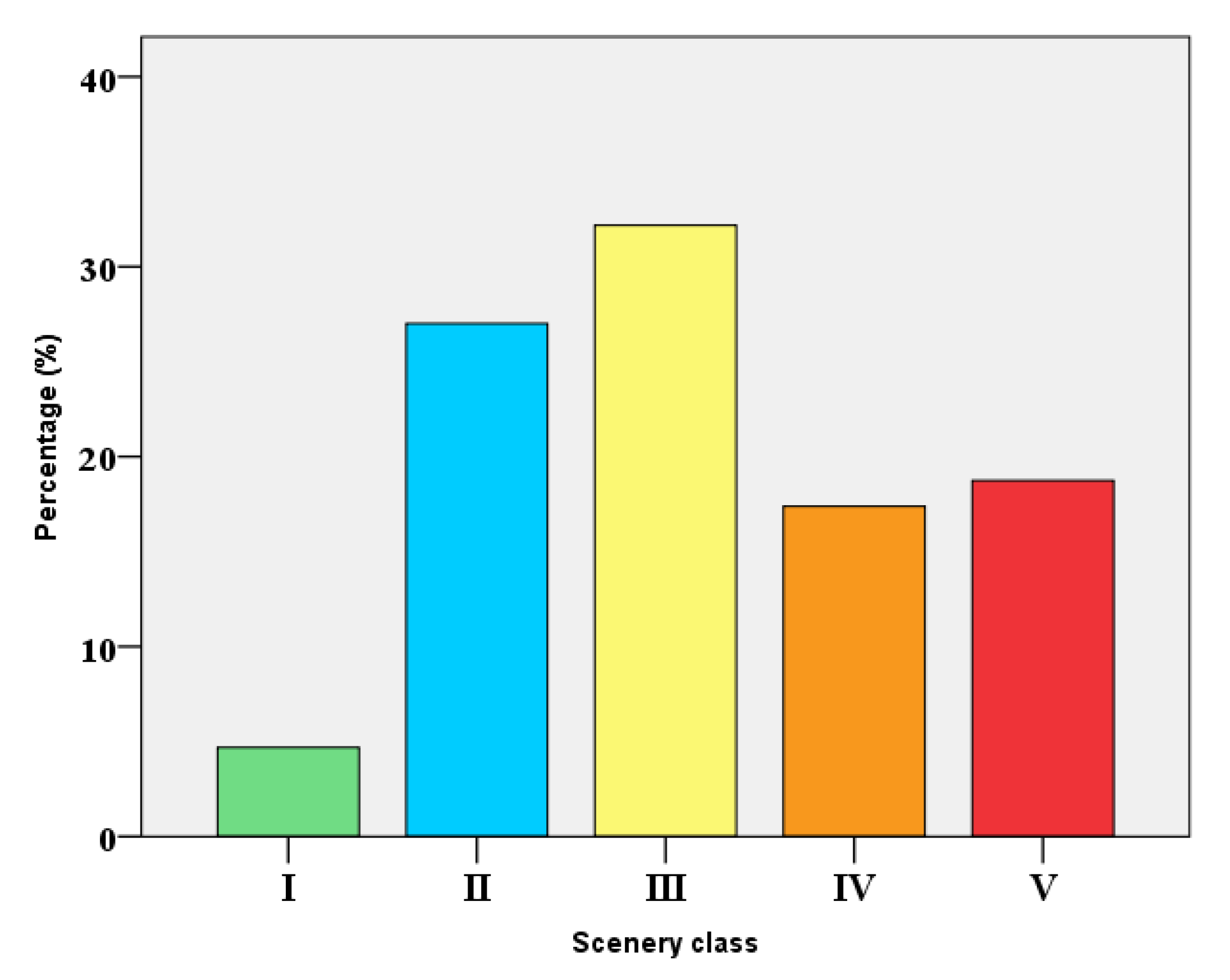
Scenic evaluations of 40 investigated sites were defined according to the methodology mentioned above (
Table 2). Thirty percent of the investigated coastal areas were included in Class I and II, 25% fitted to Class III, and 45% of the sites were in the lower classes (Class IV and V). Our results suggest that scenic classification is very correlated to the proposed classification of beach types, following their physical and functional features [
67,
68]. Actually, most of the natural beaches coincided with beaches having high scenery value (principally Classes I and II), seminatural beaches with medium-scenery values (Classes IV and III, with few exceptions in Class I, II, and IV), while Class V sites prevalently composed urban beaches. These findings are similar to those obtained in Colombia, Cuba, Spain, Brazil, and Malta by previous studies [
22,
26,
28], which confirmed the relationship between scenery, geological setting, and degree of urbanization.
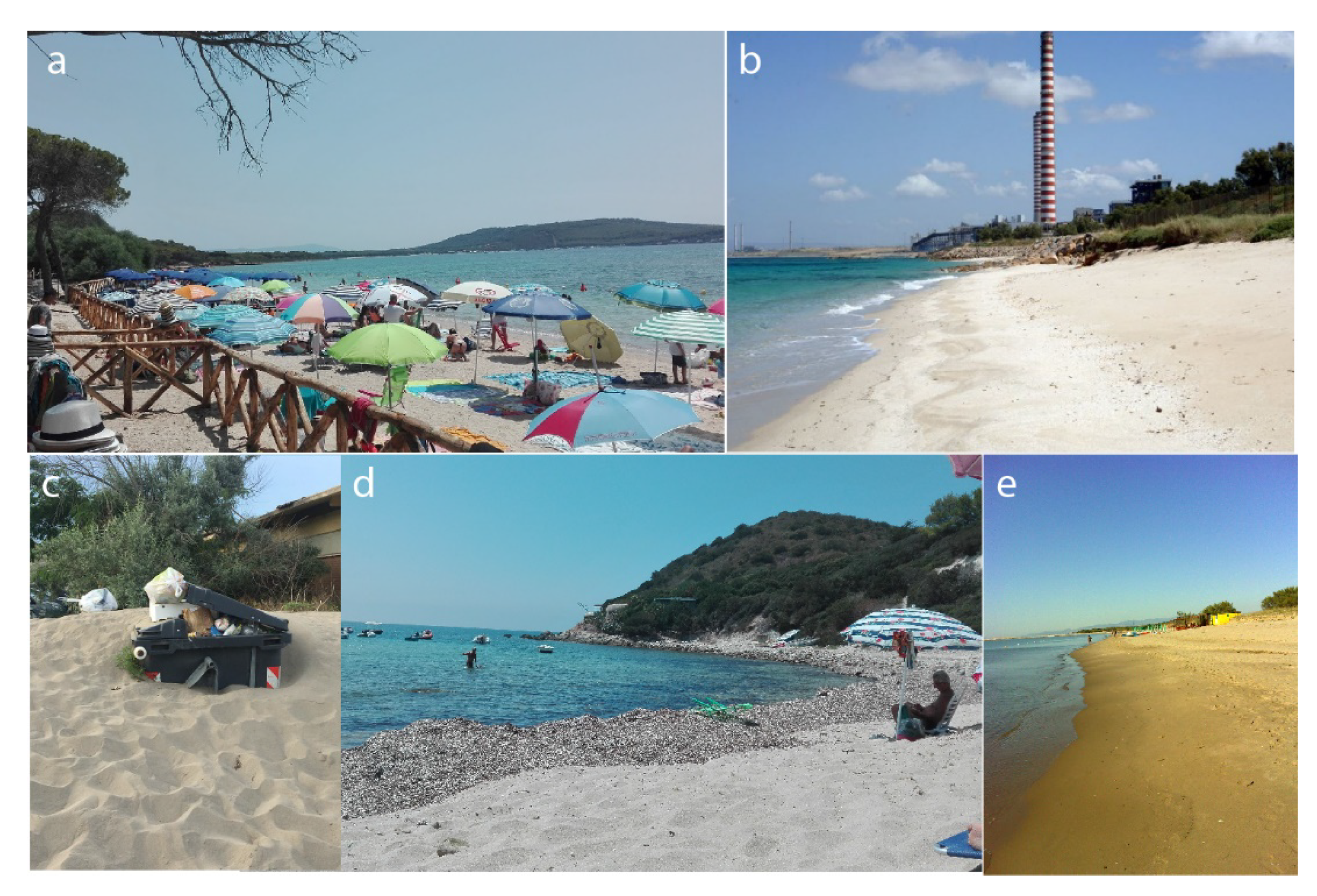
Class I sites are principally observed in the southern stretch of coast of Rosolina Mare and in small-medium pocket beaches of Alghero littoral. These littorals are characterized by the presence of natural protected areas with several features, such as lagoon, valleys, coastal rock sectors, and mountainous skyline landforms, that increase the scenic value.
The Class II sites are located in Rosolina Mare, Metaponto Lido and Alghero coastal sites and rated lower than Class I because of the increase of human occupation. For instance, Le Bombarde beach was characterized by beautiful water and beach color and some landscape features. Nevertheless, it presented some negative aspects, like the presence of litter, noise disturbance, and tourist developments, that affected the natural state of the environment.
A gradual decrease both in natural and human attributes were registered in Class III, IV, and V sites. The increase of human pressure, in some cases, altered the value of a beach that could be evaluated as natural. Magna Grecia (Metaponto Lido) and Fiume Santo (Porto Torres) beaches, for instance, are attractive areas with excellent water and beach color, but have a very insensitive urban-industrial development. Other examples, such as Ipanema—Lido di Volano (Comacchio) and Marina di Porto Caleri (Rosolina Mare), are located near small villages and show sewage discharge evidence into the beach and litter, depleting the scenic quality.
Classes IV and V, in particular, present low scores for all human parameters. In the central and southern sectors of the Lidi di Comacchio littoral, for instance, several natural parameters are affected by the flat landscape, presence of utilities such as groins, breakwaters, and revetments, and negative scores are also observed for sediment beach color, water color, and litter. Specifically concerning this last parameter, [
26] has shown that litter presence is a reason to avoid a visit at a certain beach. Consequently, concern for environmental issues, especially related to sun and sand tourism, has become a serious problem [
84]. In this context, some management measures could enhance the environmental status of the beaches and consequently their tourism, like the recovery of degraded natural spaces; the maintenance of garbage bins on beaches; a proper collection and treatment of sewage to maintain suitable recreational bathing parameters; the improvements to the existent touristic infrastructure; and the adoption of measures for environmental supervision.
At many places, erosion of coastline corresponded to the lowest ratings, as reported by [
22]. Erosion processes reduce beach width, improve the crowding effect, and induce the emplacement of different structures. Examples of this are the beaches as mentioned earlier of Lidi di Comacchio, Casoni beach, and Rosapineta Camping (North) at Rosolina Mare, Blumen Bad, Ermitage, and Mondial beaches at Metaponto Lido, and Scoglio Lungo beach at Porto Torres. In these beaches, considerable work and investments, like the removal of hard protection structures and construction of artificial dunes, would be needed [
85]. Furthermore, to reduce the crowding phenomenon, some administrative measures like the decentralization of tourism could be adopted. A recent study of [
28] suggests the use of a smartphone app that would allow to each tourist the selection of a beach according to his interests, scenery, crowding, landscape type, touristic services and facilities, bathing conditions, access, and presence of protected areas. In this way, the app gives practical information to be used by beachgoers, which can also choose between natural and urbanized sites [
28]. From a social and economic point of view, this study emphasized the users’ propensity to landscape preservation. In fact, about 60% of the interviewees were willing to pay for the preservation of the environmental quality of the landscape, with about 16 € per person each season. These percentages are slightly higher than 58% and 14.84 € reported in the Italian survey (conducted on 4126 records) by [
72]. This result is probably due to the particular condition of the selected beaches that are more natural than those reported in [
72]. Therefore, users were more willing to respect the case of semiurban and urban beaches.
Consequently, the urbanization degree of the beach has affected the WTP. This result is important because numerous studies also demonstrated that the urbanization level affects beach scenery [
7]. Thus, this implication suggests that WTP is positively correlated with scenery level. Our results support these findings, as reported in
Table 10. A number of studies have found that landscapes that are perceived as natural, like those observed in Class I, are considered more scenic than clearly human-influenced landscapes [
86,
87,
88,
89]. However, in some cases, the difference between natural scenes and human-influenced scenes is not so clear, so it could be difficult to assess by the users [
20].
Furthermore, [
7] indicates that for each scenic class there exists a related typology of users. Accordingly, the results indicate that beaches and their scenery should be managed considering both environments and specific types of users. Both in scenic and in WTP researchers, parameters were obtained from subjective observations, depending on national/cultural background, age, gender, education, and training. A study by [
90] indicated that European nationality groups agreed to a specific preferred landscape type, but cultural traits could give differences [
90]. In research for this paper, the parameters shown in
Table 2 came out in all surveys, and some differences were found because of gender and education (
Table 10). In conclusion, both aesthetic/scenic qualities of a beach and users’ attitudes and perceptions are essential aspects of consumptive experiences, as observed by [
91].
The applied methods are not without imitations. In fact, for both CSES and WTP assessment, it is useful to take into consideration some aspects that could influence the research. First of all is the variability of some scenic parameters during the seasons. Water color, for instance, could vary a lot and is more variable than the other parameters, due to the variability of the river flow. Litter is a variable parameter because it depends on the availability of cleaning services of local administrations, which often are more efficient during the bathing season. Beach width, in the case of sandy beaches, naturally varied along the seasons because of its relation to the climate and wave conditions and sand availability.
In the same way, other parameters reflect some variable conditions, like noise, discharge evidence, vegetation cover; thus, scenic surveys should be ideally carried out in different periods of the year. Secondly, although some parameters can be easily quantified (such as beach width, number of utilities, etc.), other parameters are subject to the perception over the coastal site, e.g., water color and built environment [
54]. Therefore, the CSES is a semi-quantitative method despite the fuzzy logic calculation, because humans assess the rating of each parameter (even if they are commonly experts in beach and landscape management).
Thirdly, the classification used is strongly dependent on the setting and level of human occupation. In this study, for instance, some littorals have similar coastal settings (e.g., sediment type, width, and slope) and urbanization level; therefore, some beaches could show approximately the same D value, even if their typology (remote beach vs. urban beach) and beach management (free beach vs. private beach) are different. This is because CSES has been principally developed for high rocky coasts having high variability of geomorphological and geological characteristics. For this reason, this method may be further developed to better assess the sandy flat beaches using ad hoc weighted physical parameters.
Concerning the CV, one of the inherent limitations is that this method permits one to evaluate the value of the entire environmental good, but it is less suitable for assessing the value of the single physical or non-physical components of the good (as, for example, the Choice Experiment method). It implies, among other things, that respondents can incur in the so-called yea-saying problem, i.e., the choice is referred to the entire good, whereas the willingness to pay might be only for some attributes of the goods. At the same time, in our case, the choice of adopting the CV is derived from the need of assessing the value of the beach as a whole; therefore, in our opinion, the CV is particularly adequate for this finality.


