The Spatio-Temporal Evolution of River Island Based on Landsat Satellite Imagery, Hydrodynamic Numerical Simulation and Observed Data


Abstract
:
1. Introduction
2. Study Area and Data
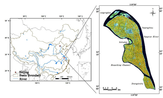
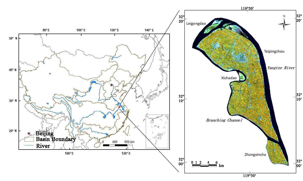
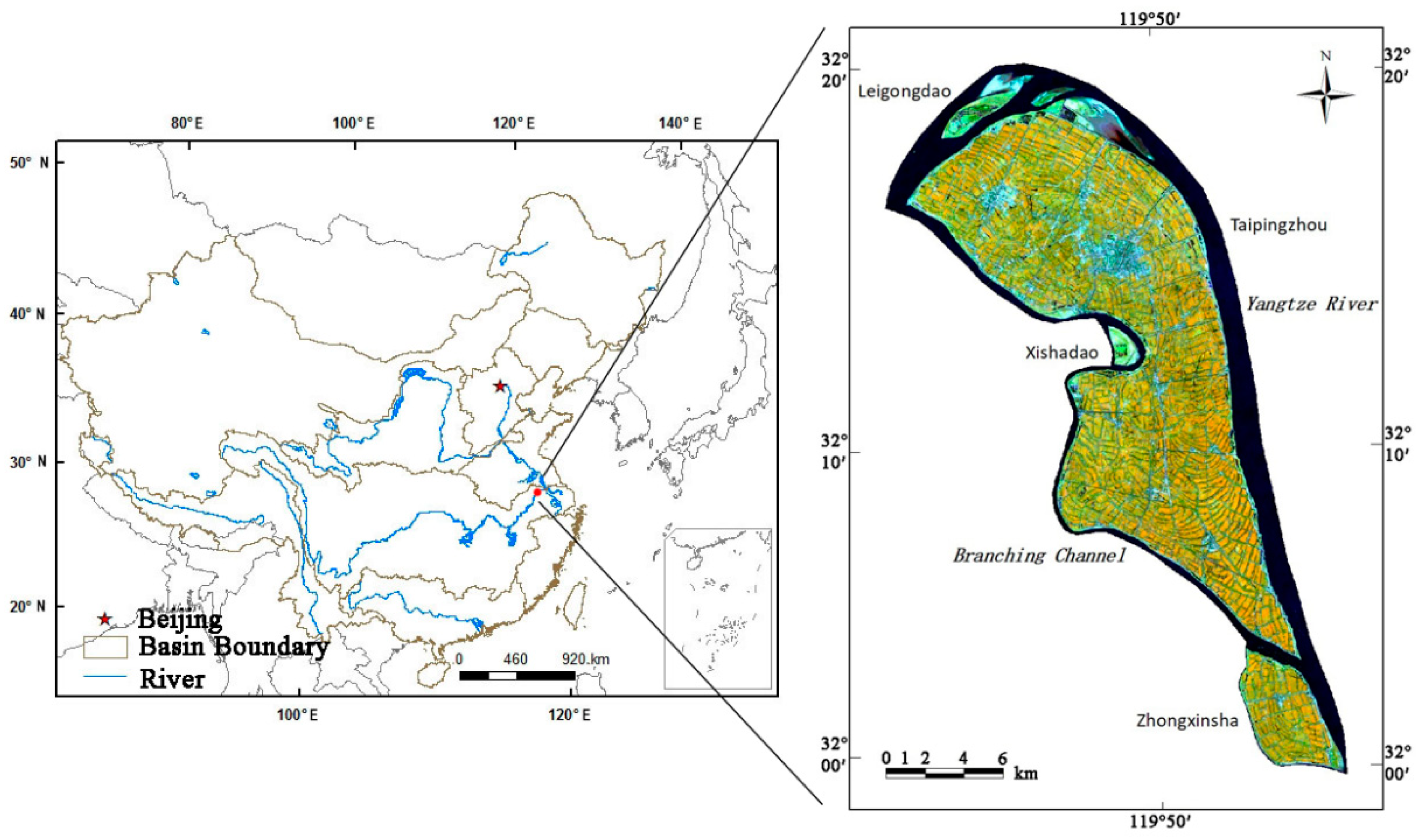
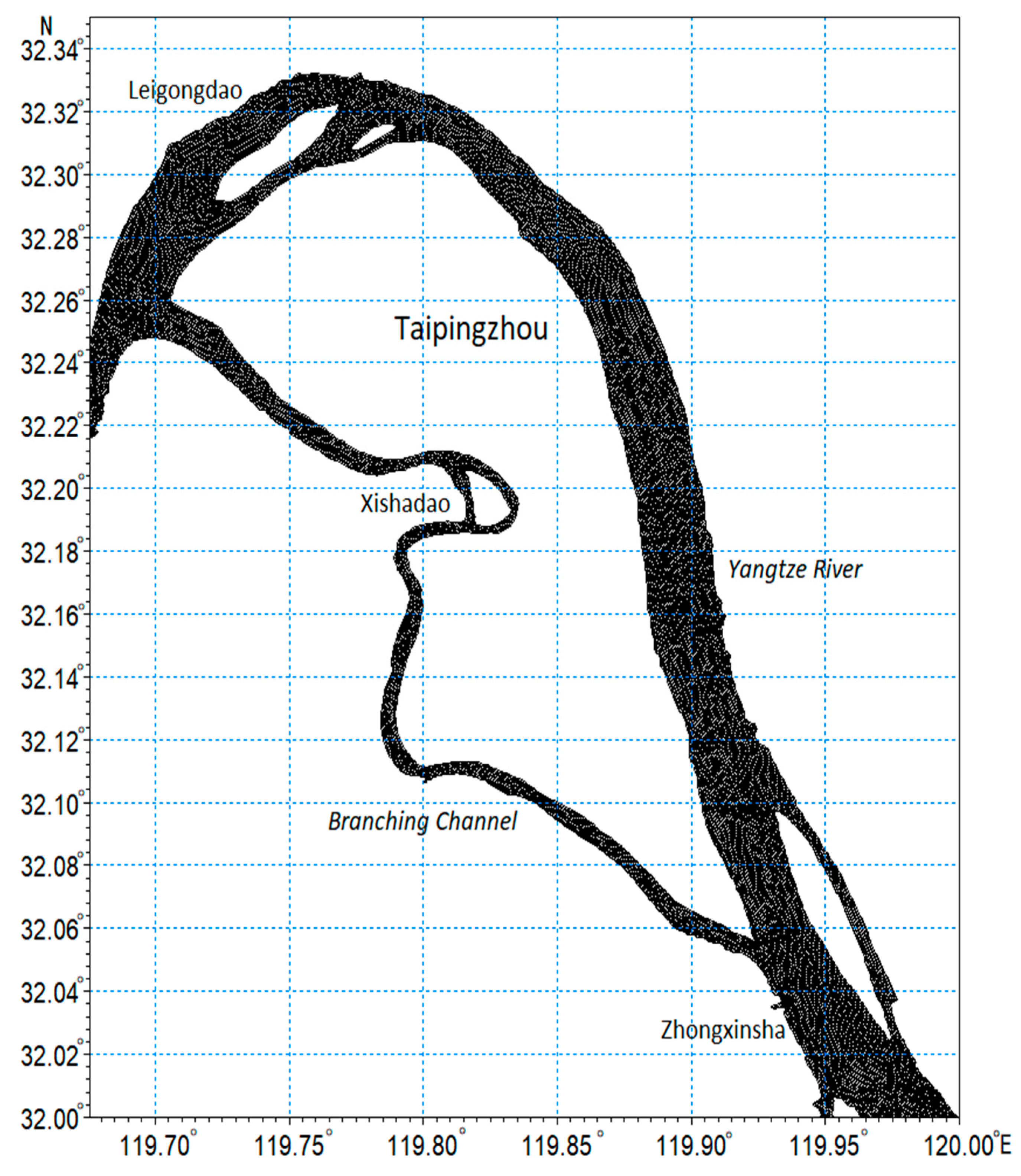
2.1. Study Area
2.2. Data
2.2.1. Remote Sensing Data
2.2.2. Hydrological Data
2.2.3. Meteorological Data
3. Methods
3.1. Image Preprocessing
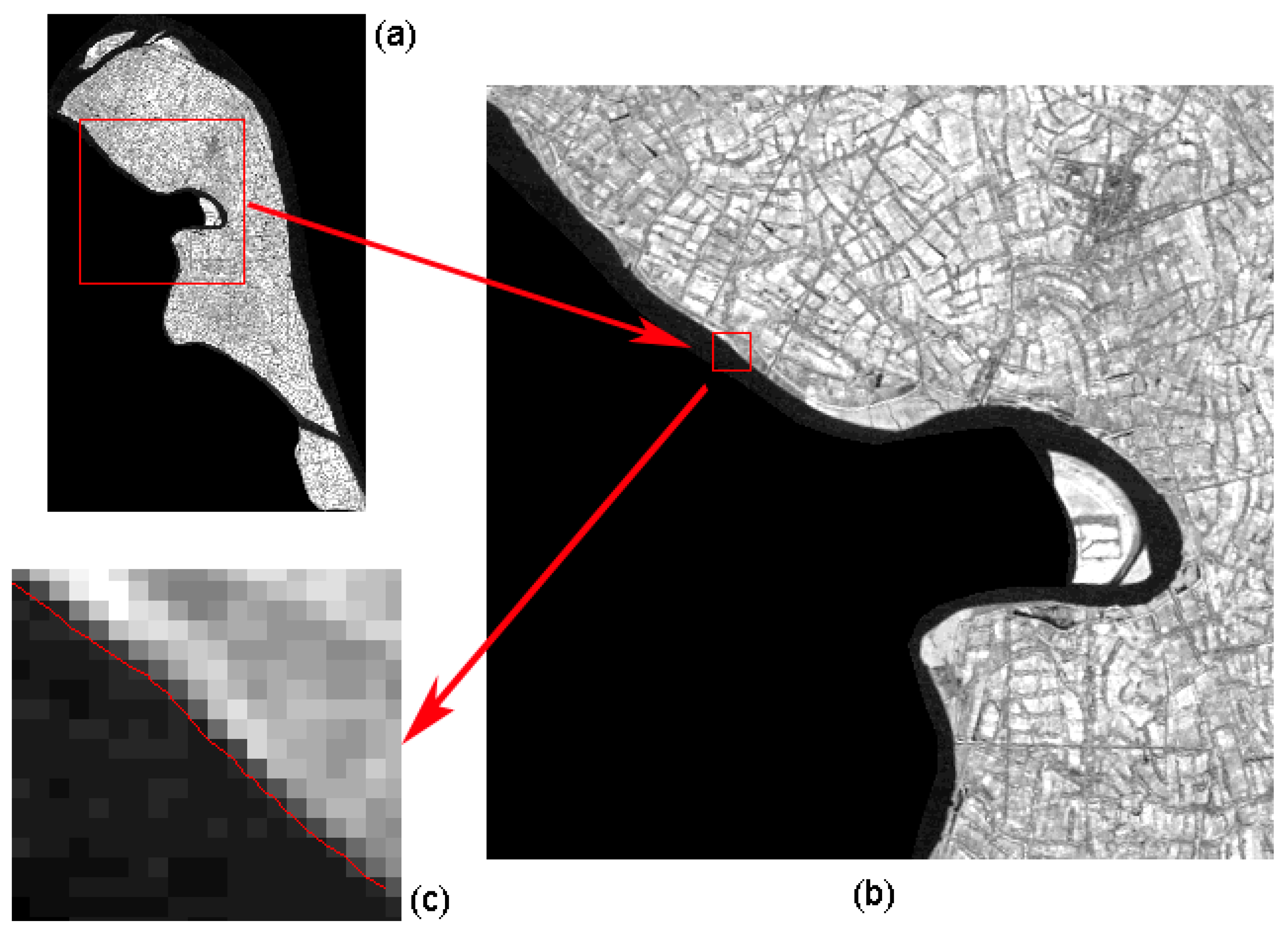
3.2. River Island Extraction Method
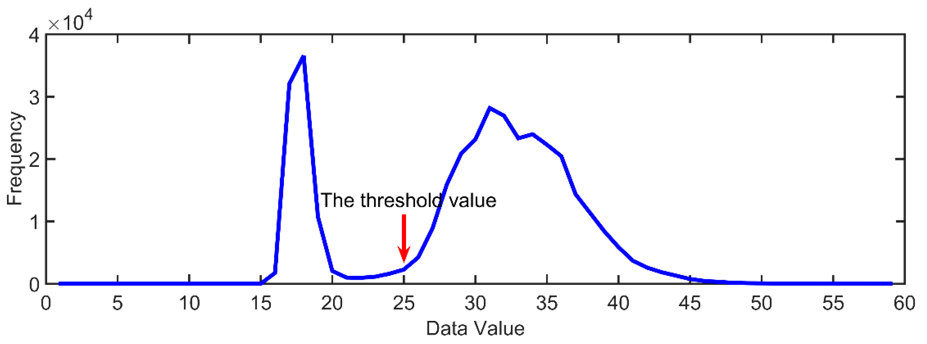
3.2.1. Threshold Value Method
3.2.2. Binarization Model
3.2.3. Cluster Analysis
3.3. Hydrodynamic Numerical Simulation
3.4. Correlation Analysis
4. Results
4.1. River Island Shape Changes
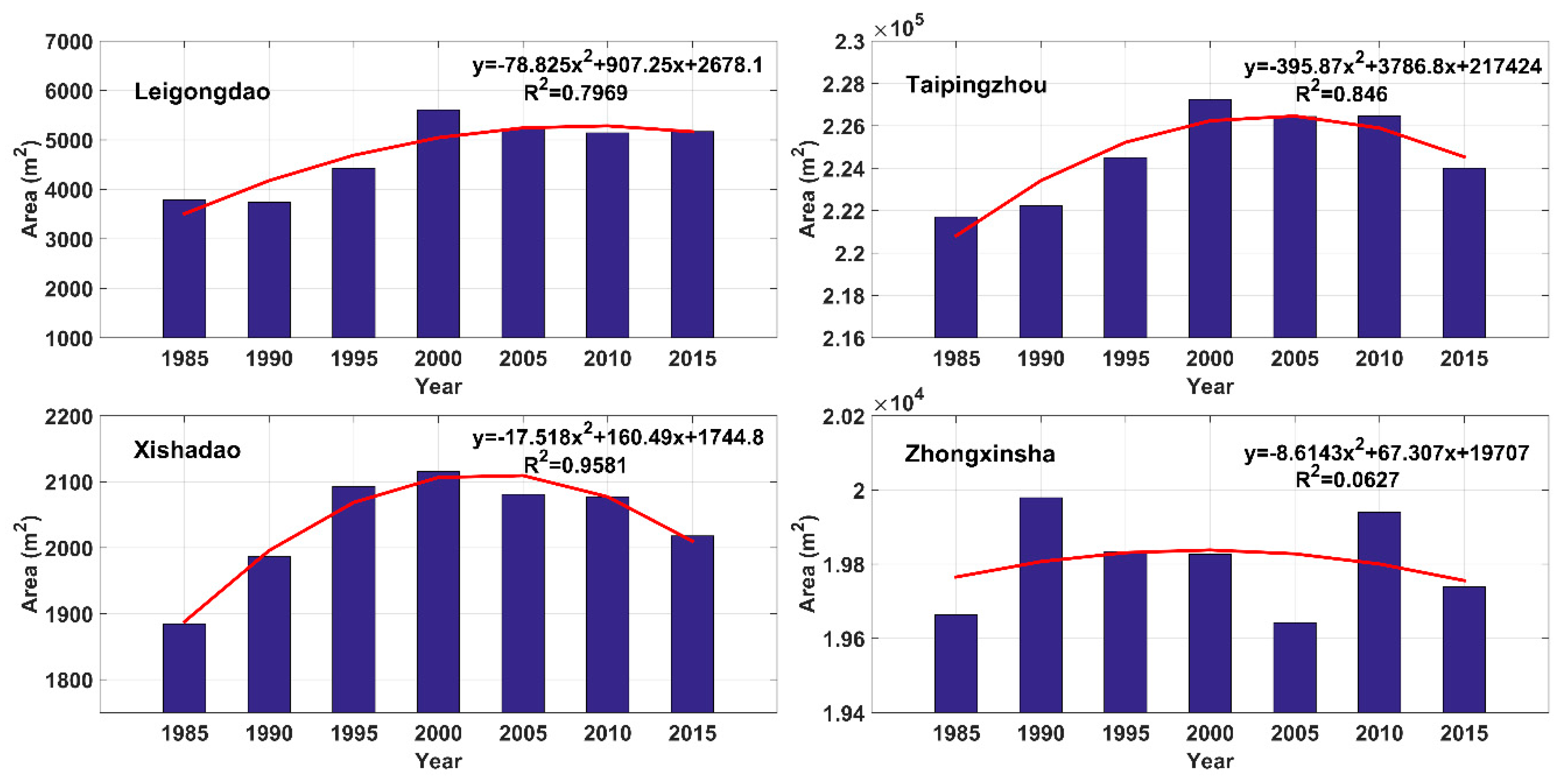
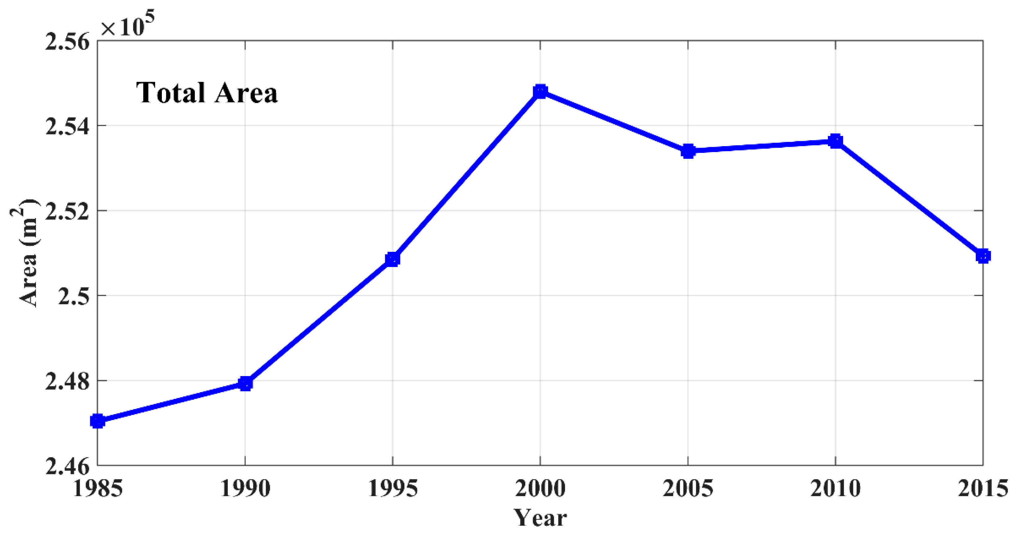
4.2. River Island Area Changes
5. Discussion
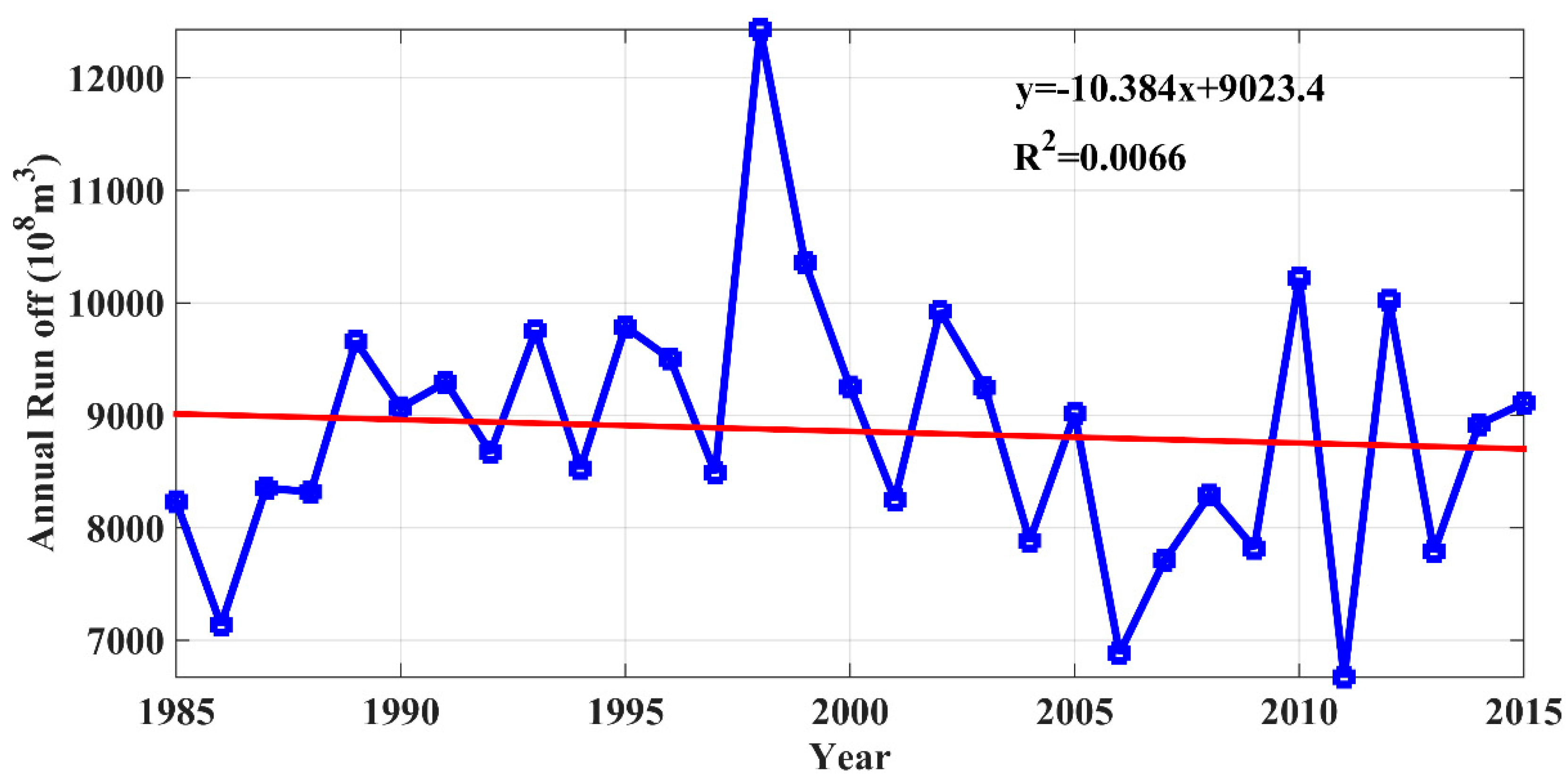
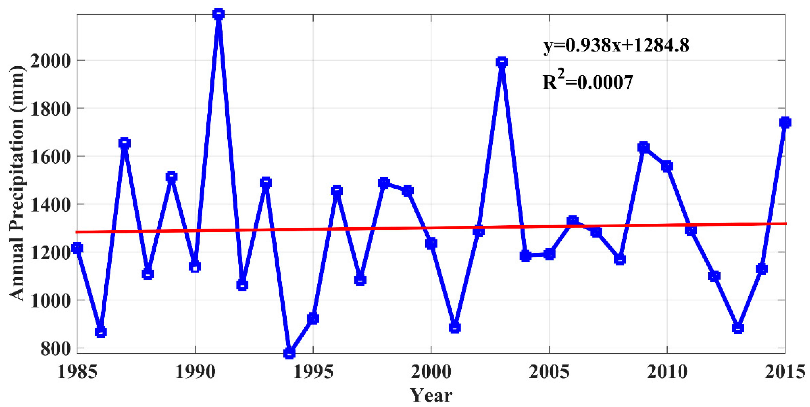
5.1. Meteorological and Hydrological Influencing Factors
5.2. The Influence of Flow Field Distribution on the Scouring and Silting in River Islands
6. Conclusions
- Between 1985 and 2015, the average annual total area of Yangzhong’s four islands was 251,224.46 m2. The total area first showed a growing trend and was followed by shrinking, but was found to be growing overall. Before 2000, the average annual growth rate was 517.08 m2; after 2000, the average annual reduction was 257.58 m2. Taipingzhou had the largest average area of 224,653.63 m2 and the fastest growth rate, reaching an average annual growth rate of 76.89 m2. The average area of Leigongdao was 4730.66 m2 with an average annual growth rate of 45.93 m2. Xishadao had the smallest area, with an average annual area of 2036.44 m2 and an average annual growth rate of 4.44 m2. The annual average area of Zhongxinsha was 19,803.73 m2, with the smallest growth rate of 2.49 m2.
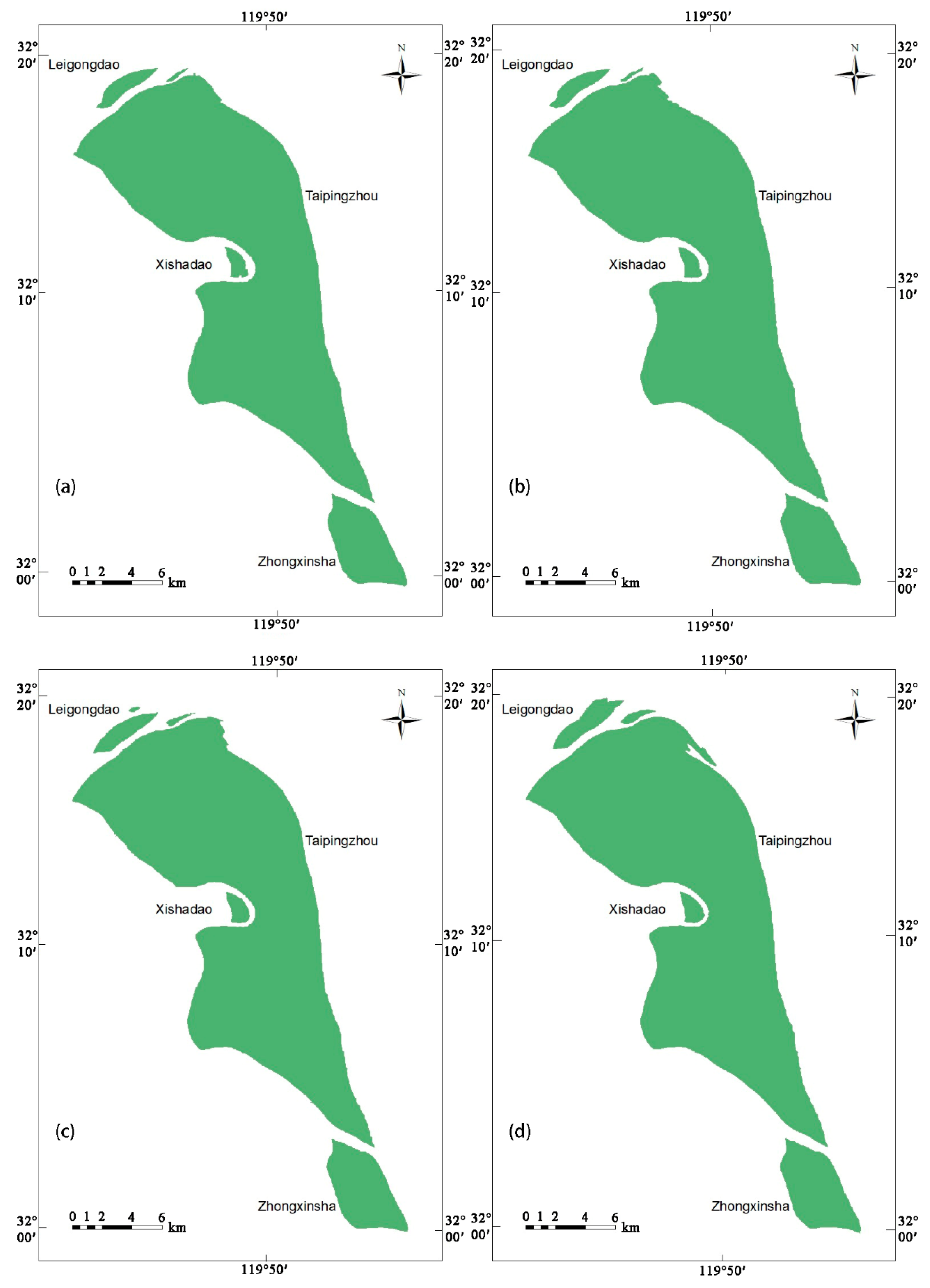
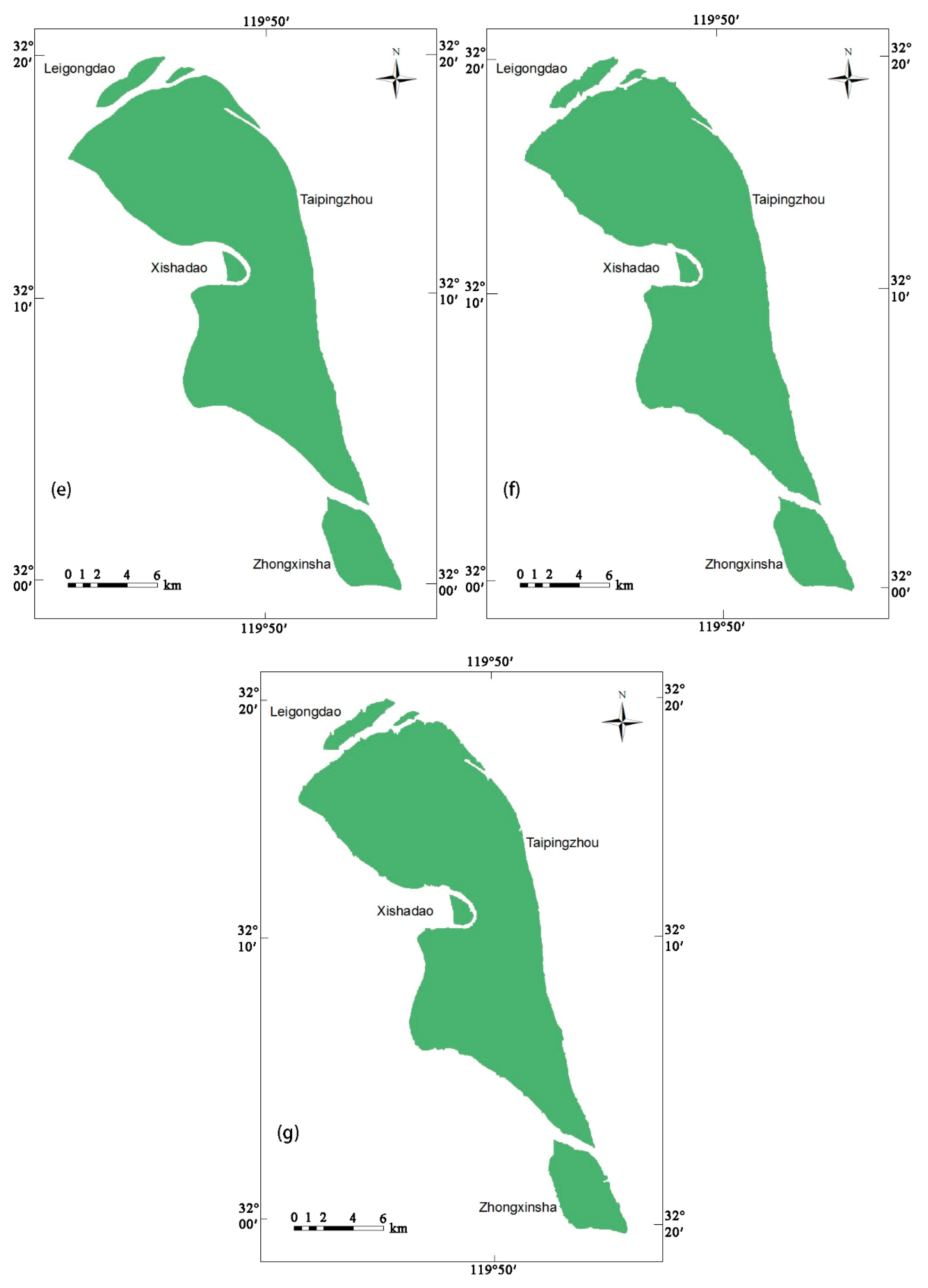
- By comparing the images, it was found that the four islands did not change much in shape over the 30 years. However, Leigongdao and Taipingzhou changed greatly in the local area. The northeastern part of Leigongdao and the northern end of Taipingzhou clearly showed new land formation, but the former showed slight erosion in 2005. The other two islands, Xishadao and Zhongxinsha, had almost no change in shape.
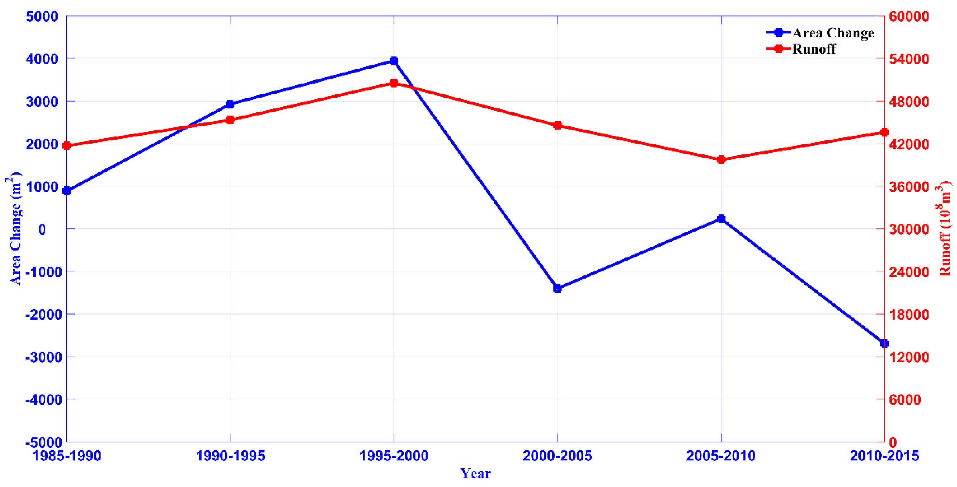
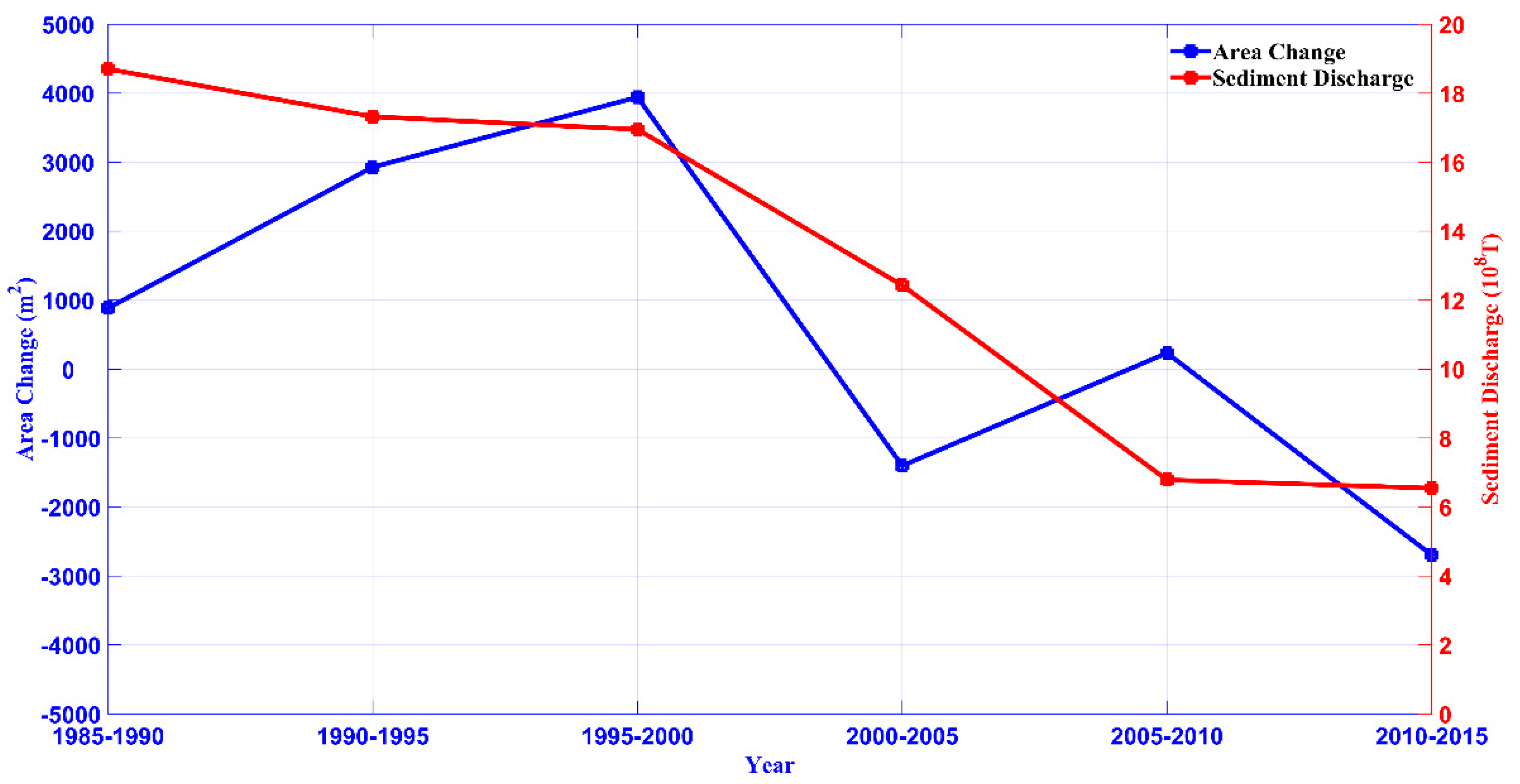
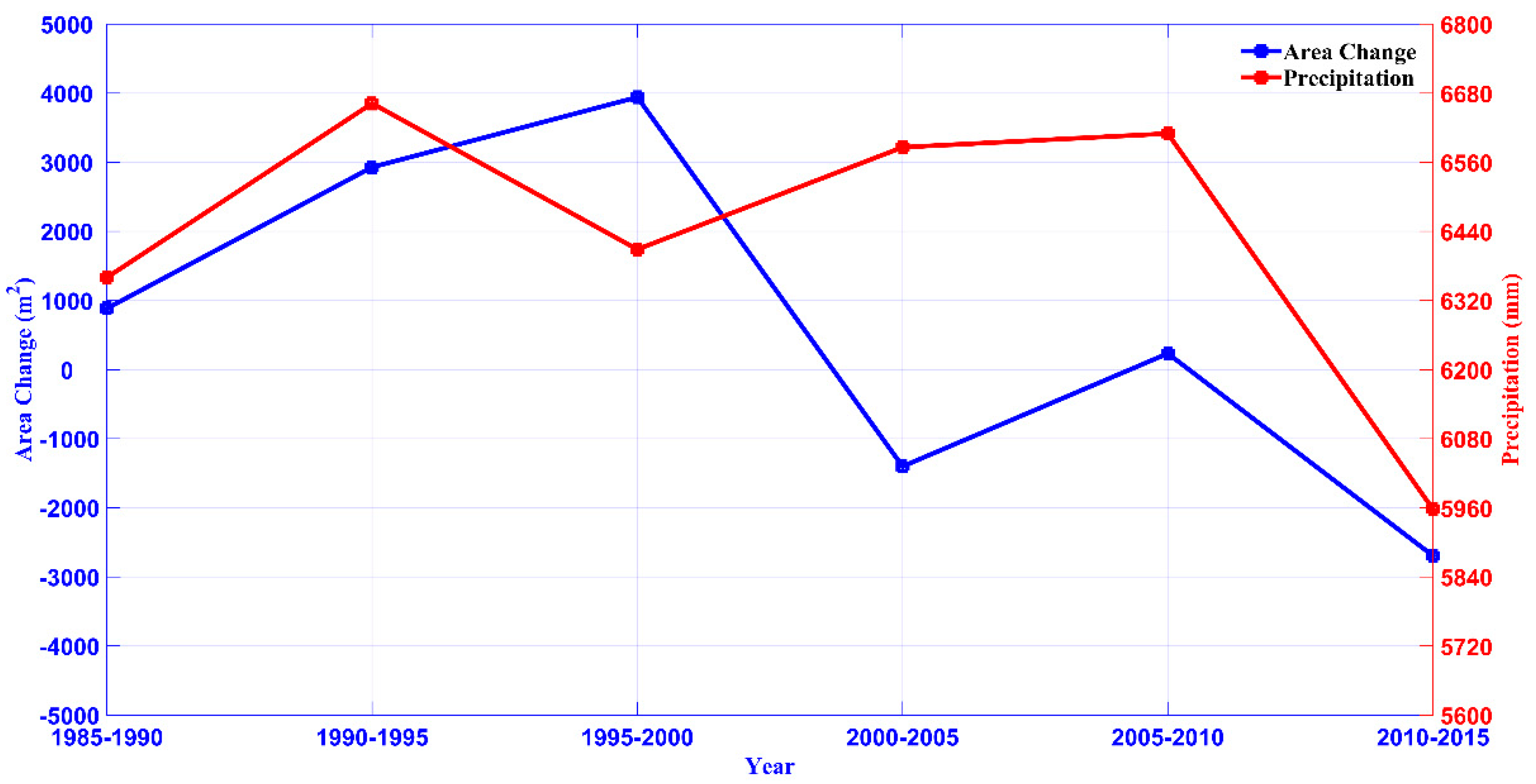
- Correlation analysis showed that the area variation of the island was proportional to the cumulative annual runoff, annual sediment discharge, and annual precipitation. Their correlation coefficients were 0.56, 0.73, and 0.50, respectively, which were moderately correlated. Within a certain range, the change of area increased with an increase in runoff, sediment discharge, and precipitation, and decreased with their decrease. The correlation coefficient between sediment discharge and area change was the largest, indicating that sediment discharge is the most important natural factor affecting the evolution of islands.
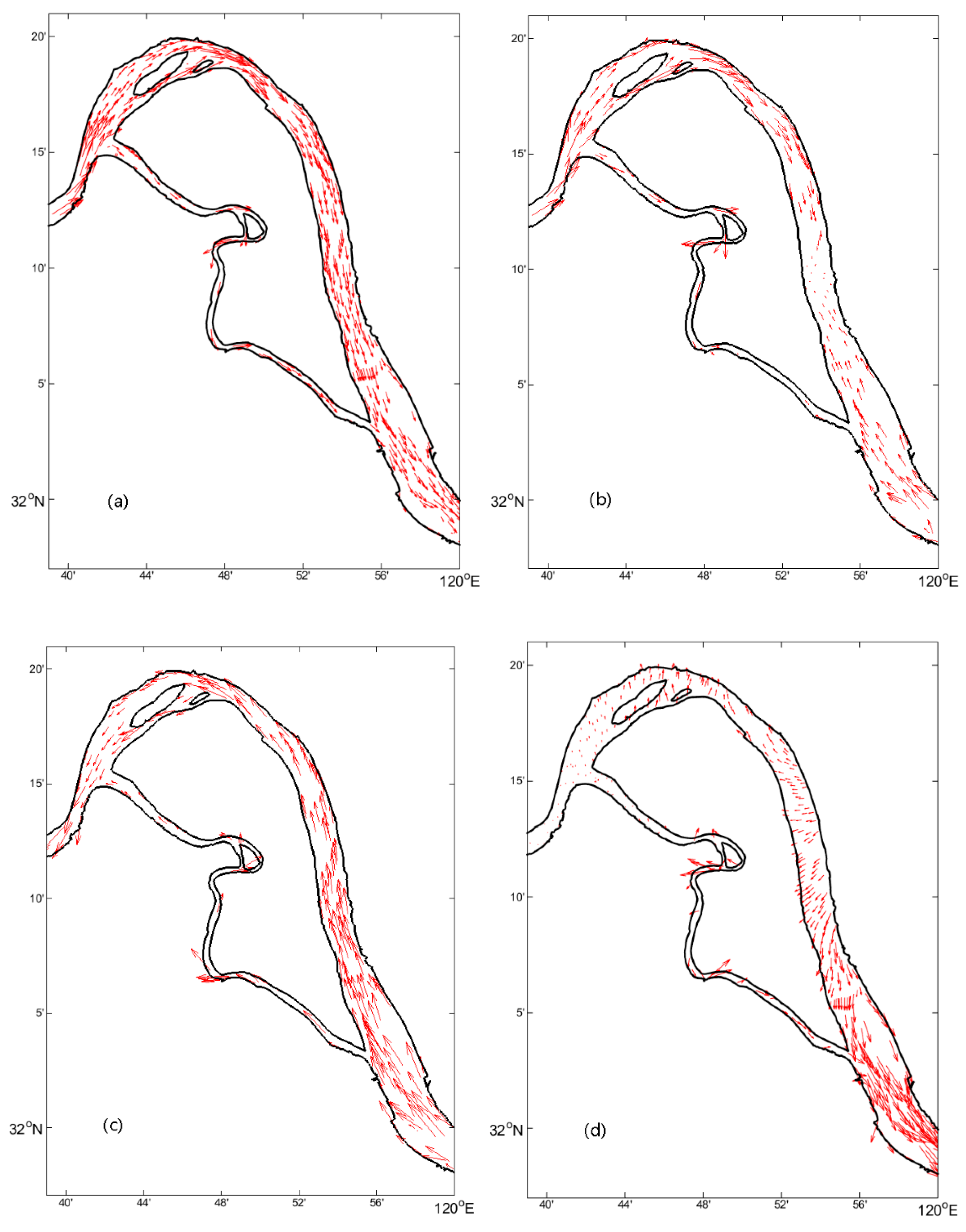
- Through the numerical simulation of the flow field in the study area, it was found that the four islands of Yangzhong City were not only affected by the upstream runoff, but also by ocean tides. The current at the heads of Leigongdao and Taipingzhou Island was small, and flowed in the opposite direction to the island, which caused sediment deposition, and the erosion of the island body was also small. Effectively, the island developed, and the area increased. However, the current in the middle and end parts of Taipingzhou was strong and flowed towards the island, causing the erosion of these places to be more serious. Thus, the island did not show signs of development.
Author Contributions
Funding
Acknowledgments
Conflicts of Interest
References
- Carling, P.; Jansen, J.; Meshkova, L. Multichannel river: Their definition and classification. Earth Surf. Process. Landf. 2014, 39, 26–37. [Google Scholar] [CrossRef]
- Huang, H.Q.; Nanson, G.C. Why some alluvial rivers develop an anabranching pattern. Water Resour. Res. 2007, 43, W07441. [Google Scholar] [CrossRef]
- Promma, K.; Zheng, C.M.; Asnachinda, P. Groundwater and surface-water interactions in a confined alluvial aquifer between two rivers: Effects of groundwater flow dynamics on high iron anomaly. Hydrogeol. J. 2007, 15, 495–513. [Google Scholar] [CrossRef]
- Wang, Z.; He, Y.; Li, Y. Sediment budget of the Yangtze River. Water Resour. Res. 2007, 43, 1–10. [Google Scholar] [CrossRef]
- Wang, Z.; Li, H.; Cai, X. Remotely Sensed Analysis of Channel Bar Morphodynamics in the Middle Yangtze River in Response to a Major Monsoon Flood in 2002. Remote Sens. 2018, 10, 1165. [Google Scholar] [CrossRef]
- Li, L.; Xia, H.; Li, Z.; Zhang, Z. Temporal-Spatial Evolution Analysis of Lake Size-Distribution in the Middle and Lower Yangtze River Basin Using Landsat Imagery Data. Remote Sens. 2015, 7, 10364–10384. [Google Scholar] [CrossRef] [Green Version]
- Ge, F.; Mao, K.; Jiang, Y.; Fan, Y.; Wang, Y.; Tan, X.; Li, J. Analysis on Characteristics and Causes of Temperature and Vegetation Changes in the Middle and Lower Reaches of the Yangtze River After the Three Gorges Dam Operation. Clim. Chang. Res. 2017, 13, 578–588. [Google Scholar]
- Chen, D.; Chen, Y.; Huang, Z. Evolution characteristics analysis of Heishazhou southern waterway of the lower Yangtze River. Hydro-Sci. Eng. 2015, 2, 84–90. [Google Scholar]
- Yang, C.; Cai, X.; Wang, X. Remote Sensing of Hydrological Changes in Tian-e-Zhou Oxbow Lake, an Ungauged Area of the Yangtze River Basin. Remote Sens. 2018, 10, 27. [Google Scholar] [CrossRef]
- Wella-Hewage, C.S.; Hewa, G.A.; Pezzaniti, D. Can water sensitive urban design systems help to preserve natural channel-forming flow regimes in an urbanised catchment? Water Sci. Technol. 2016, 73, 78–87. [Google Scholar] [CrossRef]
- Park, E.; Latrubesse, E.M. Modeling suspended sediment distribution patterns of the Amazon River using MODIS data. Remote Sens. Environ. 2014, 147, 232–242. [Google Scholar] [CrossRef]
- Calera, A.; Campos, I.; Osann, A.; D’Urso, G.; Menenti, M. Remote Sensing for CropWater Management: From ET Modelling to Services for the End Users. Sensors 2017, 17, 1197. [Google Scholar] [CrossRef] [PubMed]
- Giardino, C.; Bresciani, M.; Cazzaniga, I.; Schenk, K.; Rieger, P.; Braga, F.; Matta, E.; Brando, V.E. Evaluation of Multi-Resolution Satellite Sensors for Assessing Water Quality and Bottom Depth of Lake Garda. Sensors 2014, 14, 24116–24131. [Google Scholar] [CrossRef] [PubMed] [Green Version]
- Qiao, C.; Luo, J.C.; Sheng, Y.W.; Shen, Z.F.; Zhu, Z.W.; Ming, D.P. An adaptive water extraction method from remote sensing image based on NDWI. J. Indian Soc. Remote Sens. 2012, 40, 421–433. [Google Scholar] [CrossRef]
- Gao, C. Study on channel islands in Ma-wu-tong section of Yangtze River based on MSS/TM/ETM remote sensing image. Remote Sens. Technol. Appl. 2012, 27, 135–141. [Google Scholar]
- Gao, C.; Chen, S.; Yu, J. River islands’ change and impacting factors in the lower reaches of the Yangtze River based on remote sensing. Quat. Int. 2013, 304, 13–21. [Google Scholar] [CrossRef]
- Shi, H.; Gao, C.; Dong, C.; Xia, C.; Xu, G. Variation of River Islands around a Large City along the Yangtze River from Satellite Remote Sensing Images. Sensors 2017, 17, 2213. [Google Scholar] [CrossRef]
- Zhang, X.; Pan, D.; Chen, J.; Zhao, J.; Zhu, Q.; Huang, H. Evaluation of Coastline Changes under Human Intervention Using Multi-Temporal High-Resolution Images: A Case Study of the Zhoushan Islands, China. Remote Sens. 2014, 6, 9930–9950. [Google Scholar] [CrossRef] [Green Version]
- Li, Z.; Wang, Z.; Jia, Y.; Li, W. Evolution analysis of channel bars in the middle and lower Yangtze River before and after impoundment of Three Gorges Reservoir. Res. Environ. Yangtze Basin 2015, 24, 65–73. [Google Scholar]
- Devi, D.; Phukan, N.; Sarma, B. A Study of Erosional Depositional Activity and Land Use Mapping of Majuli River Island Using Landsat Data. In Hydrologic Modeling; Springer: Singapore, 2018; Volume 81, pp. 187–200. [Google Scholar]
- Mani, P.; Kumar, R.; Chatterjee, C. Erosion study of a part of Majuli River-Island using remote sensing data. J. Indian Soc. Remote Sens. 2003, 81, 187–200. [Google Scholar] [CrossRef]
- Kotoky, P.; Bezbaruah, D.; Baruah, J. Erosion activity on Majuli—The largest river island of the world. Curr. Sci. 2003, 84, 929–932. [Google Scholar]
- Sankhua, R.N.; Sharma, N.; Garg, P.K.; Pandey, A.D. Use of remote sensing and ANN in assessment of erosion activities in Majuli, the world’s largest river island. Int. J. Remote Sens. 2005, 26, 4445–4454. [Google Scholar] [CrossRef]
- Li, H.; Wang, P.; Su, W.; Wang, G.; Ren, S. Study on Influence of River Island on Distribution of Circulation in Curve and Branch Channel. In Informatics and Management Science II; Springer: London, UK, 2013; pp. 205–211. [Google Scholar]
- Picco, L.; Mao, L.; Rainato, R.; Lenzi, M.A. Medium-term fluvial island evolution in a disturbed gravel-bed river (Piave River, Northeastern Italian Alps). Geogr. Ann. Ser. A Phys. Geogr. 2014, 96, 83–97. [Google Scholar] [CrossRef]
- Huang, S.; Liao, Q.; Hua, M.; Wu, X.; Bi, K.; Yan, C.; Chen, B.; Zhang, B. Survey of heavy metal pollution and assessment of agricultural soil in Yangzhong district, Jiangsu Province, China. Chemosphere 2007, 67, 2148–2155. [Google Scholar] [CrossRef] [PubMed]
- Jiangsu Province Water Resources Department (JPWRD). Jiangsu Province Water Resources Bulletin; Jiangsu Province Water Resources Department: Nanjing, China, 2006–2015.
- Ministry of Water Resources (MWR). China River Sediment Bulletin; Ministry of Water Resources: Beijing, China, 2000–2015.
- Changjiang Water Resources Commission (CWRC). Changjiang Sediment Bulletin; Changjiang Water Resources Commission of the Ministry of Water Resources: Wuhan, China, 2000–2015. [Google Scholar]
- Chen, C.; Liu, H.; Beardsley, R.C. An Unstructured Grid, Finite-Volume, Three-Dimensional, Primitive Equations Ocean Model: Application to Coastal Ocean and Estuaries. J. Atmos. Ocean. Technol. 2003, 20, 159–186. [Google Scholar] [CrossRef]
- Chen, C.; Huang, H.; Beardsley, R.C.; Liu, H.; Xu, Q.; Cowles, G.W. A finite volume numerical approach for coastal ocean circulation studies: Comparisons with finite difference models. J. Geophys. Res. Oceans 2007, 112, 83–87. [Google Scholar] [CrossRef]
- Song, Z.; Mao, L. Salt water encroachment at the Yangtze River Estuary. Water Resour. Prot. 2002, 3, 27–30. [Google Scholar]
- Lin, C.; Gao, X. Effect of water conservancy project on the changes of runoff and sediment in Dongting Lake. J. Lake Sci. 1994, 6, 33–39. [Google Scholar] [Green Version]


| Date | Satellite/Sensor | Path/Row | Center Latitude (°W) | Center Longitude (°E) | Resolution (m) |
|---|---|---|---|---|---|
| 11 January 1985 | Landsat5/TM | 119/38 | 31.74873 | 120.40145 | 30 |
| 26 February 1990 | Landsat5/TM | 119/38 | 31.77380 | 120.26261 | 30 |
| 24 February 1995 | Landsat5/TM | 119/38 | 31.75787 | 120.34795 | 30 |
| 1 March 2000 | Landsat7/ETM+ | 119/38 | 31.74300 | 120.35570 | 30 |
| 19 February 2005 | Landsat5/TM | 119/38 | 31.75269 | 120.37703 | 30 |
| 8 January 2010 | Landsat7/ETM+ | 119/38 | 31.73645 | 120.36478 | 30 |
| 5 December 2014 | Landsat7/ETM+ | 119/38 | 31.73690 | 120.39874 | 30 |
| Station Name | Station Number | Latitude (°W) | Longitude (°E) | Location |
|---|---|---|---|---|
| Datong | 60,315 | 30.77 | 117.62 | Guichi District, Chizhou City, Anhui Province |
| Jiujiang | 60,290 | 29.72 | 115.97 | Xunyang District, Jiujiang City, Jiangxi Province |
| Station Name | Network: ID | Latitude (degree) | Longitude (degree) | Elevation (m) |
|---|---|---|---|---|
| NANJING, CH | GHCND: CHM00058238 | 31.56W | 118.54E | 15 |
| Year | 1985 | 1990 | 1995 | 2000 | 2005 | 2010 | 2015 |
|---|---|---|---|---|---|---|---|
| Satellite/Sensor | Landsat5/TM | Landsat5/TM | Landsat5/TM | Landsat7/ETM+ | Landsat5/TM | Landsat7/ETM+ | Landsat7/ETM+ |
| Threshold Value | 25 | 25 | 30 | 25 | 25 | 40 | 40 |
| Year | 1990–1985 | 1995–1990 | 2000–1995 | 2005–2000 | 2010–2005 | 2015–2010 |
|---|---|---|---|---|---|---|
| 884.7 | 2929.5 | 3942.0 | −1401.3 | 233.1 | −2695.5 |
© 2018 by the authors. Licensee MDPI, Basel, Switzerland. This article is an open access article distributed under the terms and conditions of the Creative Commons Attribution (CC BY) license (http://creativecommons.org/licenses/by/4.0/).
Share and Cite
Shi, H.; Cao, Y.; Dong, C.; Xia, C.; Li, C. The Spatio-Temporal Evolution of River Island Based on Landsat Satellite Imagery, Hydrodynamic Numerical Simulation and Observed Data. Remote Sens. 2018, 10, 2046. https://doi.org/10.3390/rs10122046
Shi H, Cao Y, Dong C, Xia C, Li C. The Spatio-Temporal Evolution of River Island Based on Landsat Satellite Imagery, Hydrodynamic Numerical Simulation and Observed Data. Remote Sensing. 2018; 10(12):2046. https://doi.org/10.3390/rs10122046
Chicago/Turabian StyleShi, Haiyun, Yuhan Cao, Changming Dong, Changshui Xia, and Chunhui Li. 2018. "The Spatio-Temporal Evolution of River Island Based on Landsat Satellite Imagery, Hydrodynamic Numerical Simulation and Observed Data" Remote Sensing 10, no. 12: 2046. https://doi.org/10.3390/rs10122046
APA StyleShi, H., Cao, Y., Dong, C., Xia, C., & Li, C. (2018). The Spatio-Temporal Evolution of River Island Based on Landsat Satellite Imagery, Hydrodynamic Numerical Simulation and Observed Data. Remote Sensing, 10(12), 2046. https://doi.org/10.3390/rs10122046