
A Multidisciplinary Approach for the Mapping, Automatic Detection and Morphometric Analysis of Ancient Submerged Coastal Installations: The Case Study of the Ancient Aegina Harbour Complex

 ,
, 
 , ,
, , 
 and
and 
Abstract
:1. Introduction
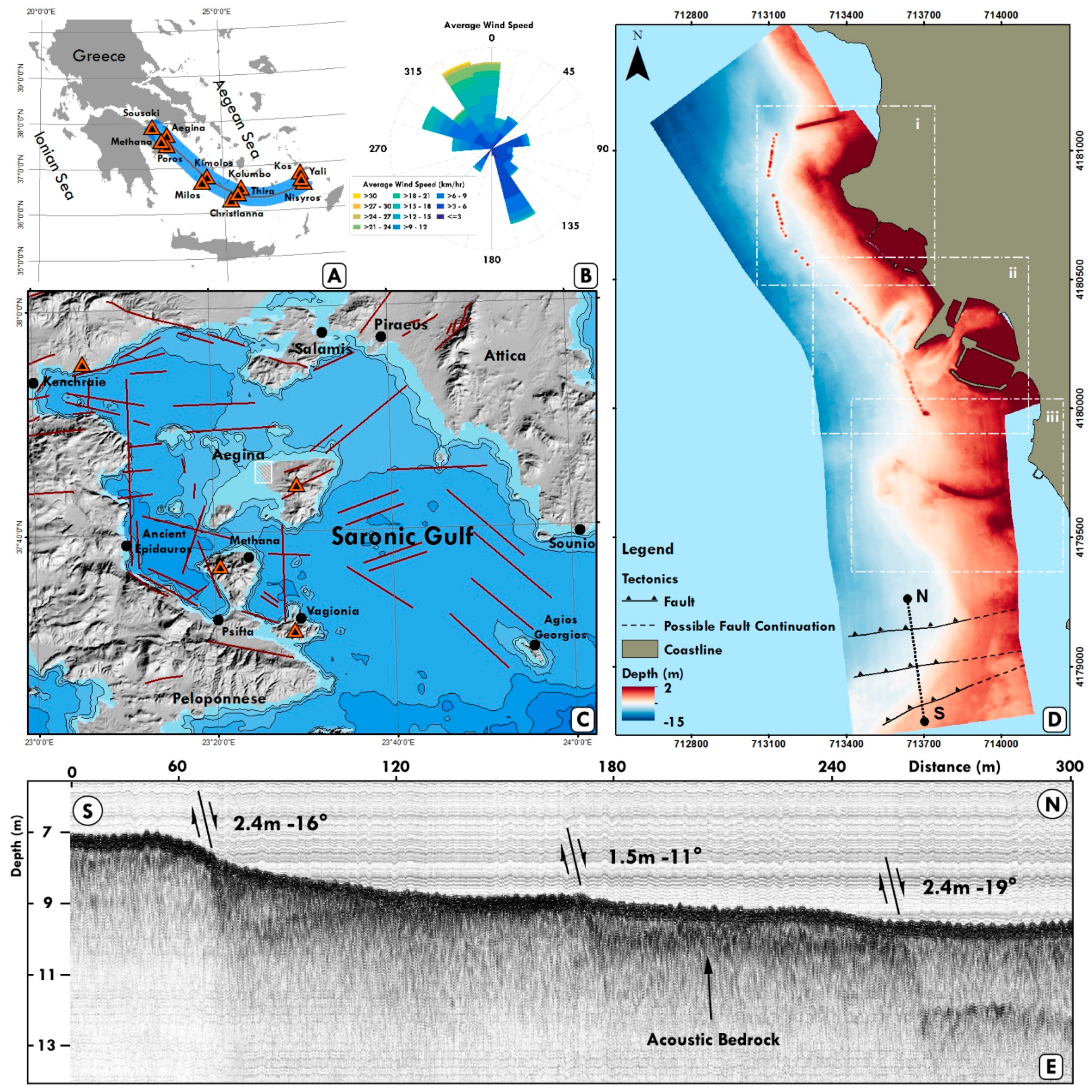
2. Geomorphological/Geological Setting
2.1. Study Area & Oceanography
2.2. Structural Setting
3. Methodology
3.1. Remote Sensing Survey
3.2. Detection and Parametrization of Submerged Antiquities
3.3. Photogrammetric Implications
4. Results
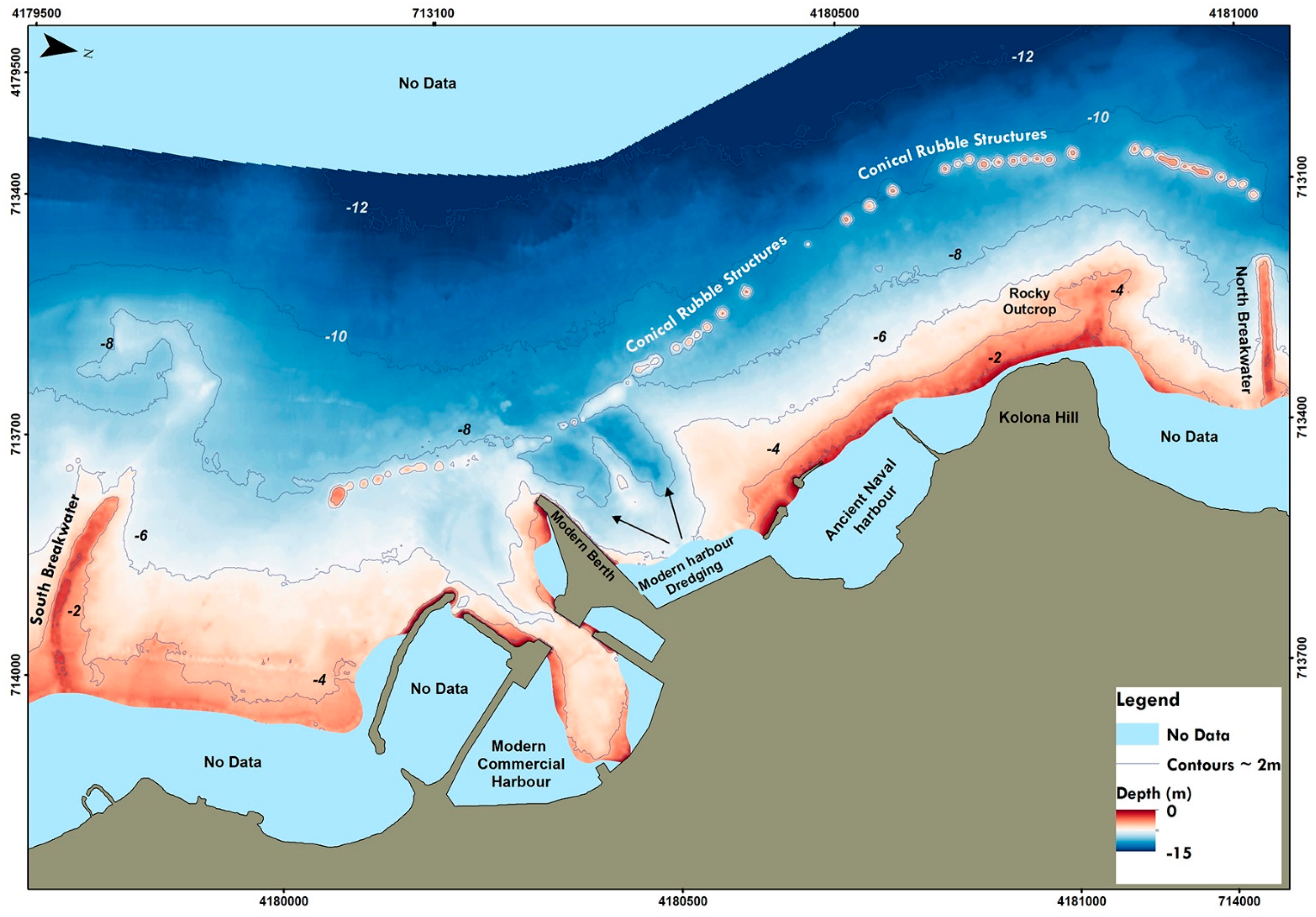
4.1. Geomorphology of the Coastal Area of Aegina City
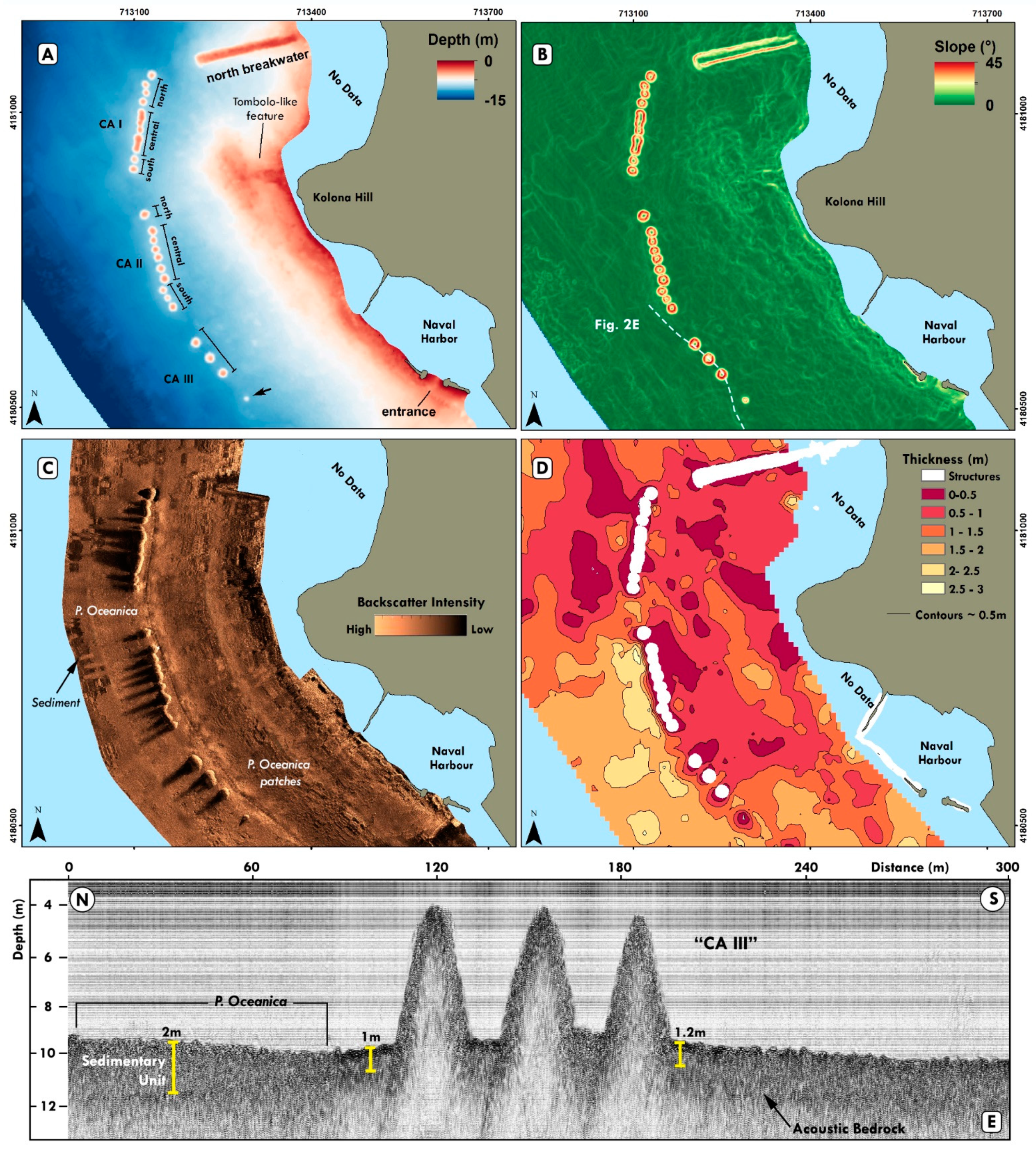
4.1.1. Northern Area
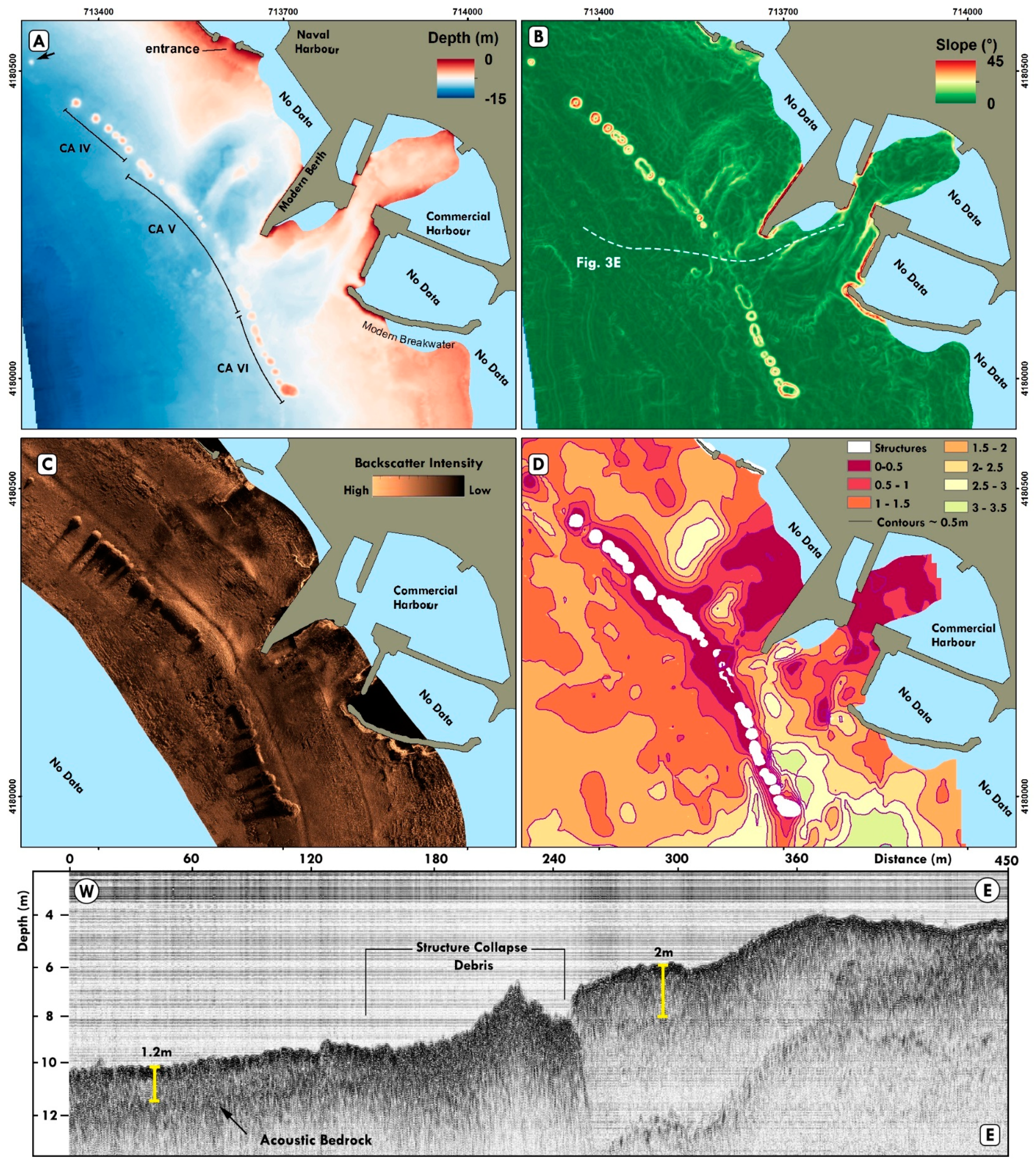
4.1.2. Central Area
4.1.3. Southern Area
4.2. Automatic Detection and Morphometric Analysis of the Ancient Harbour Facilities
4.2.1. Automatic Detection of Submerged Ancient Structures
4.2.2. Seafloor Classification and Spatial Planning Analysis
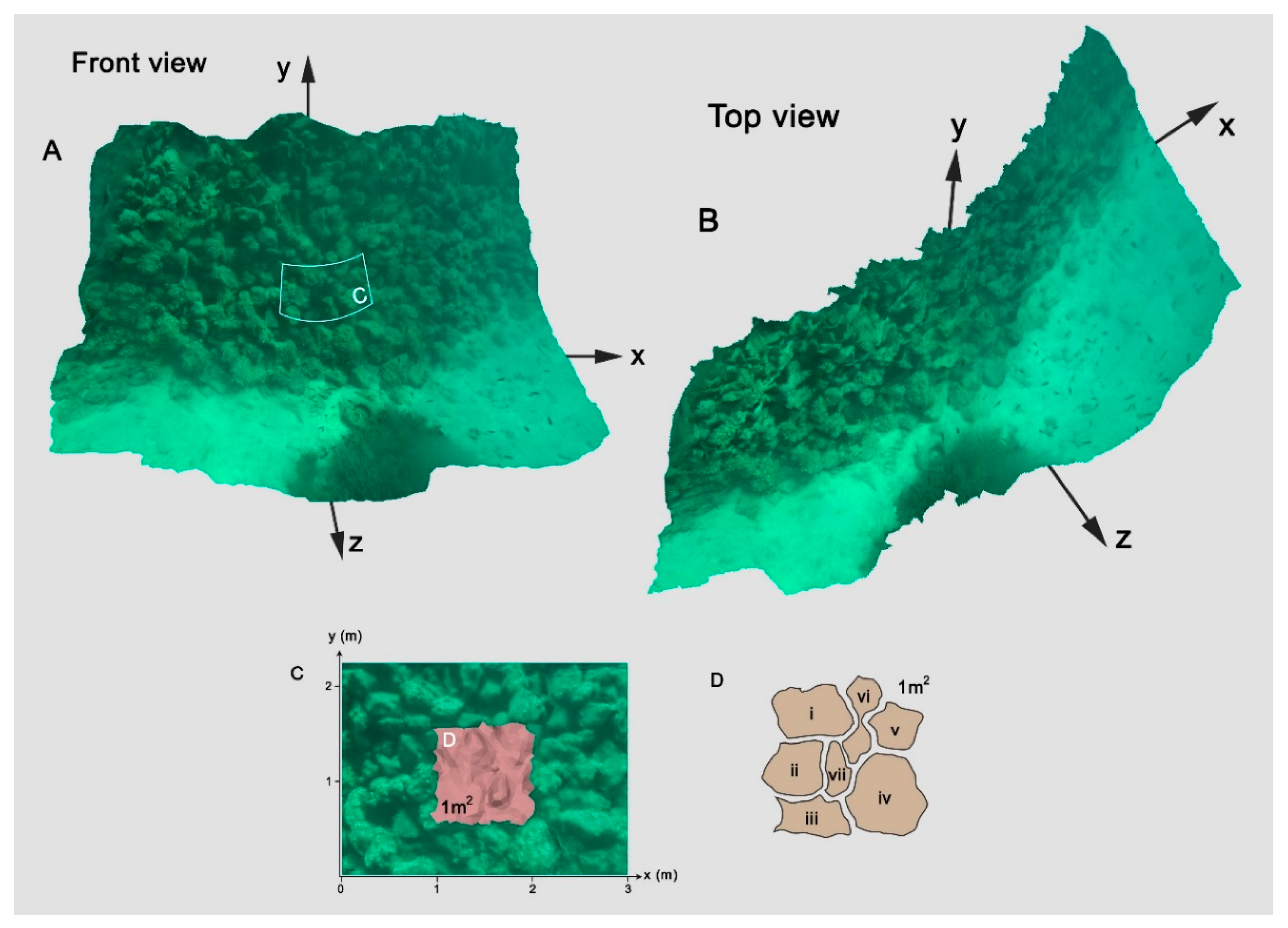
4.2.3. Morphometric Analysis and Parametrization
4.2.4. Photogrammetric Implication
4.3. Condition Assessment of the Submerged Archaeological Remains
5. Discussion
5.1. Documentation of Underwater Cultural Heritage Using Remote Sensing
5.2. Advanced Harbour Engineering Planning & Issues of Functionality of the Conical Rubble Structures Arrays
5.2.1. Shielding
5.2.2. Sheltering
5.2.3. Relative Sea-Level Rise Implications
5.3. Underwater Cultural Heritage Preservation Status
6. Conclusions
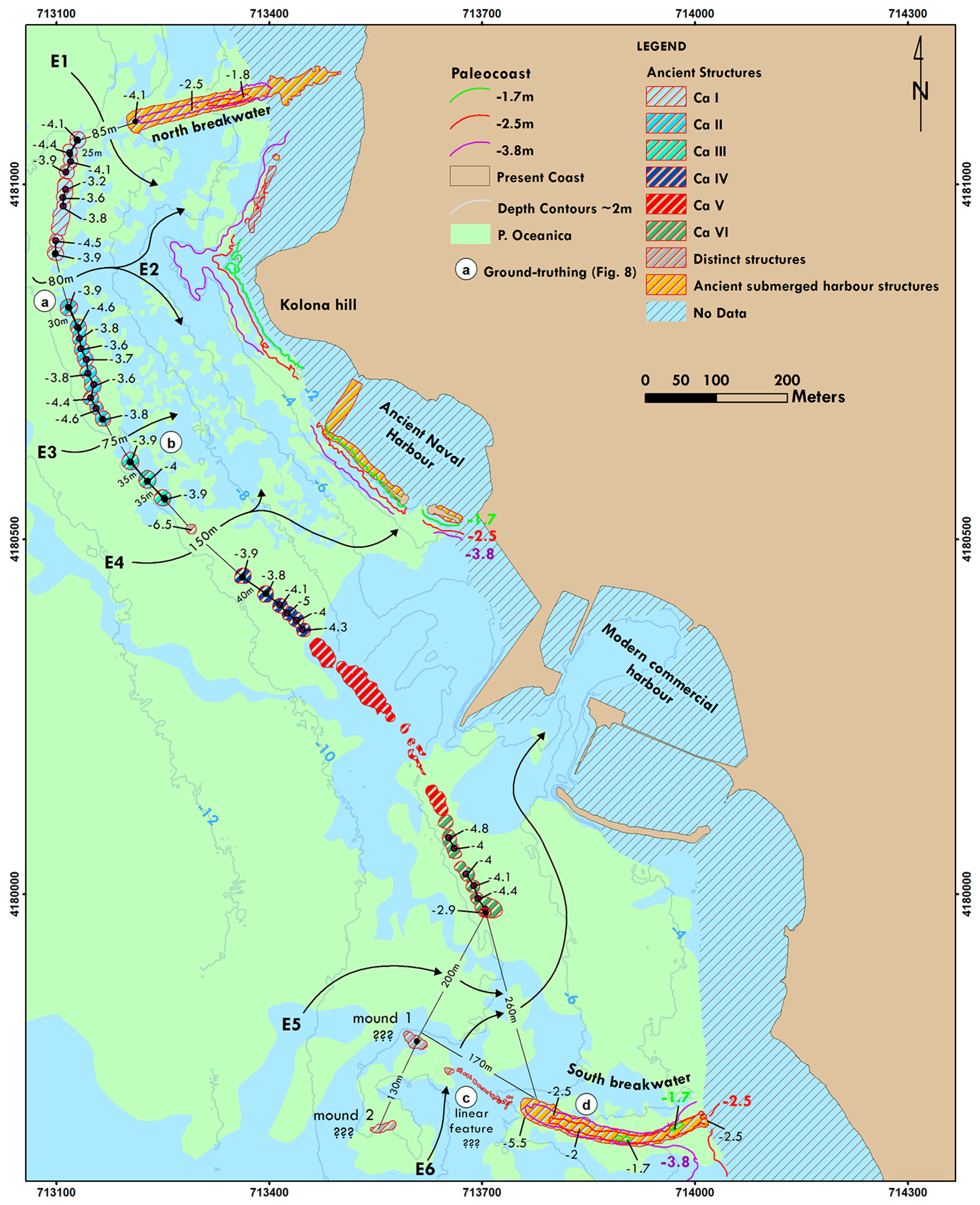
- The use of this methodological approach proved successful in identifying geomorphological features (i.e., faults, sediment thickness, seabed bathymetry). The whole extent of the submerged and semi-buried archaeological site was delimited using the collected acoustic data while automatic seafloor segmentation techniques were used to detect the submerged harbour facilities (conical rubble structures and breakwaters) in detail while revealing a previously unknown underwater area that contains archaeological remains.
- The submerged harbor facilities’ spatial planning analysis revealed the advanced harbour engineering plan, unique in the Greek world, that offered multiple and controlled passages to the ancient harbours’ basins. This strongly indicates that a hydrographic survey preceded the construction of the harbor facilities by the ancient harbour engineers.
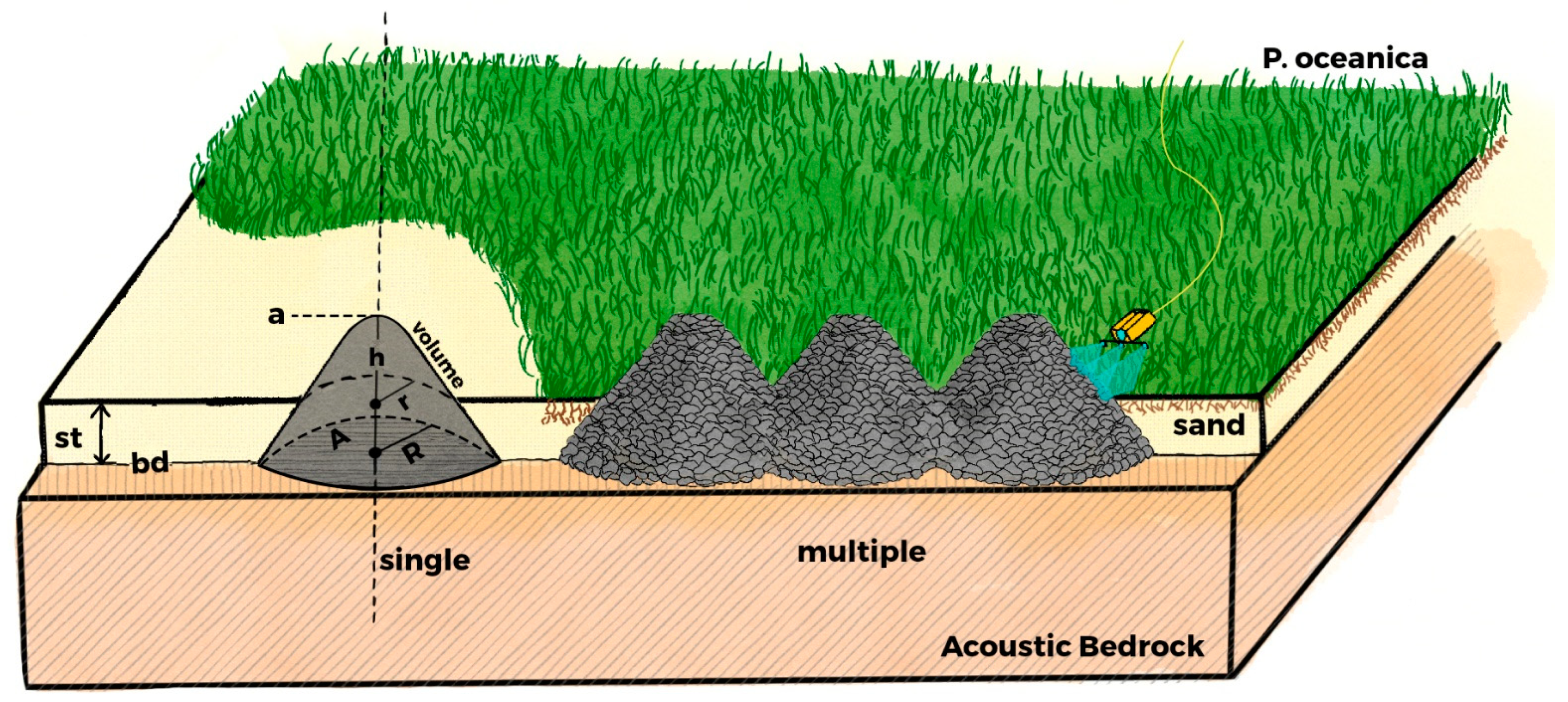
- The parameterization and morphometric analysis (geometric characteristics and depth distribution of the structures, burial depth) of the submerged harbor facilities’ (conical rubble structures) acoustic data showed that their use to prevent enemies from entering the harbors (shielding) but also as submerged breakwaters (sheltering) could be two possible functional scenarios. However, this remains to be verified by the study of the morphology and the dating of the conical rubble structures complex by underwater archaeological survey and excavation, as well as wave modelling that will use the current seafloor bathymetry as input.
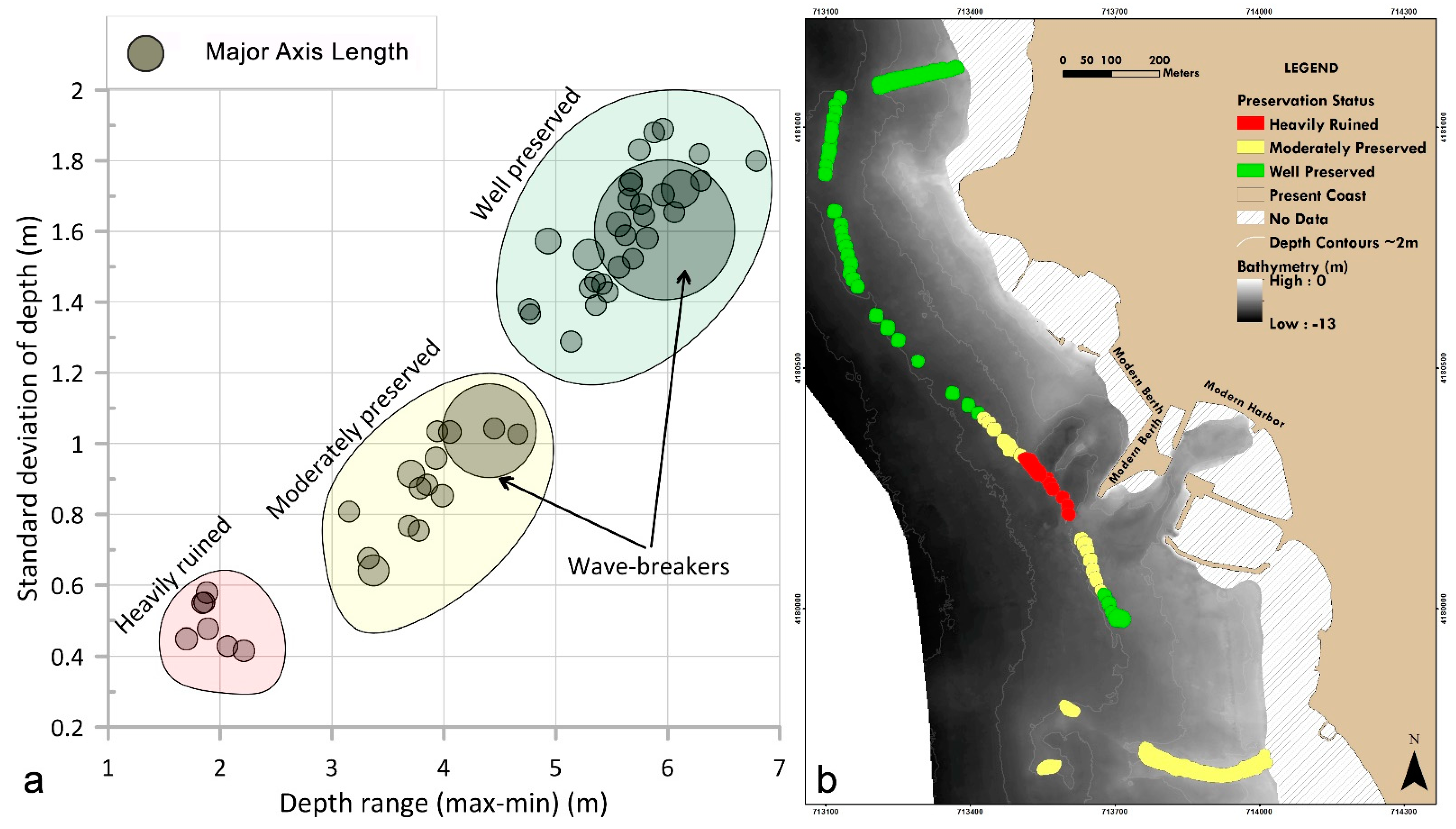
- Morphometric analysis of the submerged site revealed its preservation status, indicating the partly destroyed structures affected by the modern harbor activities.
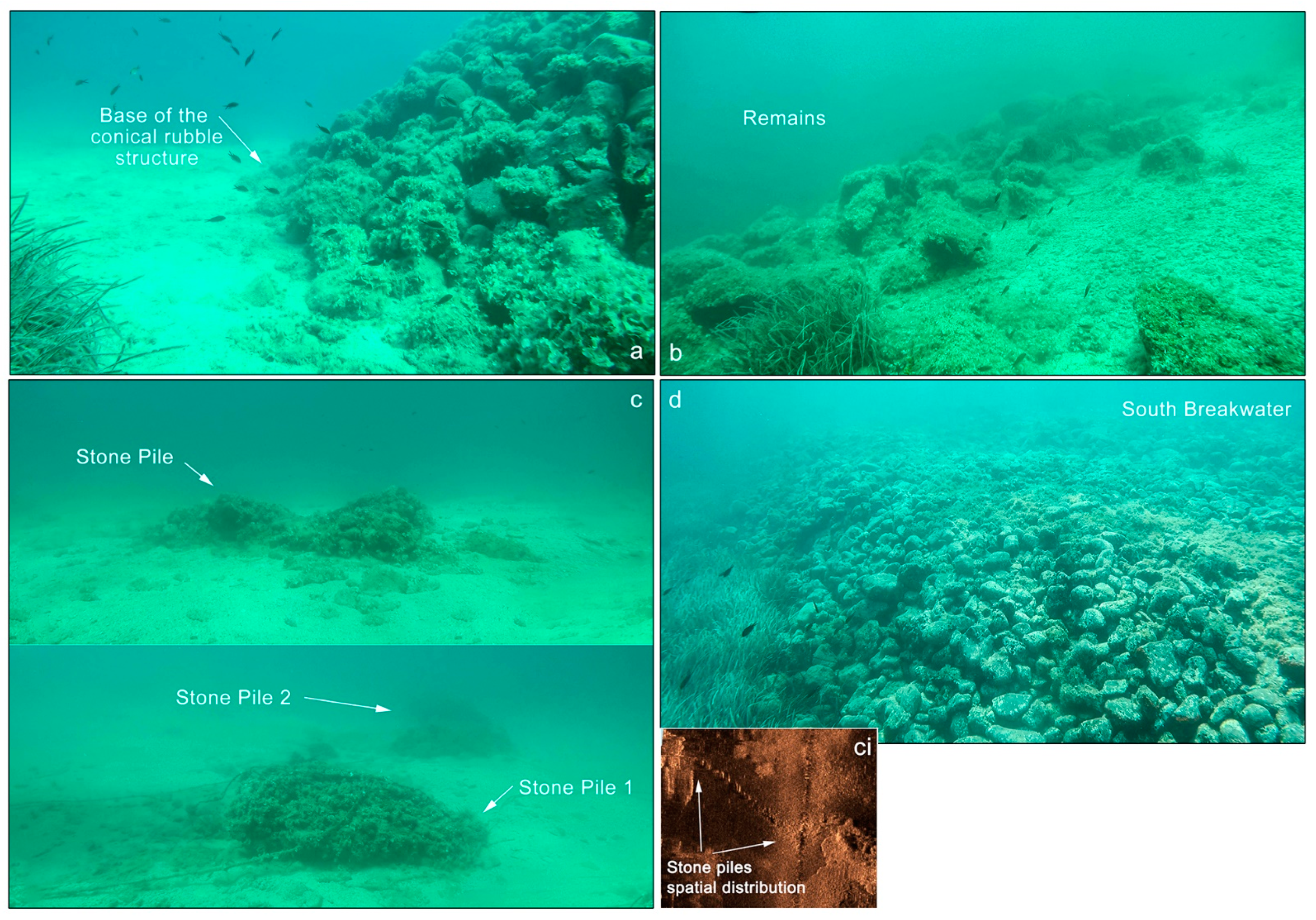
- Photogrammetry, using an ROV equipped with action cameras, was applied on one of the archaeological structures (i.e., conical rubble structure), revealing the microstructure such as the size of the rubble material and the amount needed for their construction. These estimations will be further explored by systematic archaeological documentation and detailed underwater photogrammetric recording, that have now been initiated.
Author Contributions
Funding
Institutional Review Board Statement
Informed Consent Statement
Data Availability Statement
Acknowledgments
Conflicts of Interest
References
- Pausanias Description of Greece 2.29.6–2.32.4. Available online: https://pindar.chs.harvard.edu/read/urn:cts:greekLit:tlg0525.tlg001.the-center-for-hellenic-studies-translations-eng:2.29.6-2.32.4 (accessed on 5 August 2021).
- Welter, G. Aeginetica XIII-XXIV. Archäologischer Anz. 1938, 53, 480–540. [Google Scholar]
- Knoblauch, P. Die Hafenlagen der Stadt Ägina; Athens, 1973; Volume 27, Available online: https://www.oeaw.ac.at/resources/Record/990002942240504498 (accessed on 28 September 2021).
- Mourtzas, N.D.; Kolaiti, E. Historical coastal evolution of the ancient harbor of Aegina in relation to the Upper Holocene relative sea level changes in the Saronic Gulf, Greece. Palaeogeogr. Palaeoclimatol. Palaeoecol. 2013, 392, 411–425. [Google Scholar] [CrossRef]
- Kolaiti, E.; Mourtzas, N.D. Upper Holocene sea level changes in the West Saronic Gulf, Greece. Quat. Int. 2016, 401, 71–90. [Google Scholar] [CrossRef]
- Triantafillidis, I.; Koutsoumba, D. The Harbour Landscape of Aigina. In Proceedings of the 13th ISBSA Amsterdam Eelde: Ships And Maritime Landscapes, Amsterdam, The Netherlands, 8–12 October 2012; pp. 165–170. [Google Scholar]
- Gkionis, P.; Papatheodorou, G.; Geraga, M.; Fakiris, E.; Christodoulou, D.; Tranaka, K. A marine geoarchaeological investigation for the cultural anthesis and the sustainable growth of Methoni, Greece. J. Cult. Herit. 2020, 42, 158–170. [Google Scholar] [CrossRef]
- Ferentinos, G.; Fakiris, E.; Christodoulou, D.; Geraga, M.; Dimas, X.; Georgiou, N.; Kordella, S.; Papatheodorou, G.; Prevenios, M.; Sotiropoulos, M. Optimal sidescan sonar and subbottom profiler surveying of ancient wrecks: The ‘Fiskardo’ wreck, Kefallinia Island, Ionian Sea. J. Archaeol. Sci. 2020, 113, 105032. [Google Scholar] [CrossRef]
- Geraga, M.; Papatheodorou, G.; Ferentinos, G.; Fakiris, E.; Christodoulou, D.; Georgiou, N.; Dimas, X.; Iatrou, M.; Kordella, S.; Sotiropoulos, G.; et al. The study of an ancient shipwreck using marine remote sensing techniques, in Kefalonia Island (Ionian Sea), Greece. Archaeol. Maritima Mediterr. 2015, 12, 183–200. [Google Scholar]
- Geraga, M.; Christodoulou, D.; Eleftherakis, D.; Papatheodorou, G.; Fakiris, E.; Dimas, X.; Georgiou, N.; Kordella, S.; Prevenios, M.; Iatrou, M.; et al. Atlas of Shipwrecks in Inner Ionian Sea (Greece): A Remote Sensing Approach. Heritage 2020, 3, 1210–1236. [Google Scholar] [CrossRef]
- Papatheodorou, G.; Geraga, M.; Christodoulou, D.; Fakiris, E.; Iatrou, M.; Georgiou, N.; Dimas, X.; Ferentinos, G. The Battle of Lepanto Search and Survey Mission (1971–1972) by Throckmorton, Edgerton and Yalouris: Following Their Traces Half a Century Later Using Marine Geophysics. Remote Sens. 2021, 13, 3292. [Google Scholar] [CrossRef]
- Geraga, M.; Papatheodorou, G.; Agouridis, C.; Kaberi, H.; Iatrou, M.; Christodoulou, D.; Fakiris, E.; Prevenios, M.; Kordella, S.; Ferentinos, G. Palaeoenvironmental implications of a marine geoarchaeological survey conducted in the SW Argosaronic gulf, Greece. J. Archaeol. Sci. Reports 2017, 12, 805–818. [Google Scholar] [CrossRef] [Green Version]
- Westley, K.; Plets, R.; Quinn, R. Holocene Paleo-Geographic Reconstructions of the Ramore Head Area, Northern Ireland, Using Geophysical and Geotechnical Data: Paleo-Landscape Mapping and Archaeological Implications. Geoarchaeology 2014, 29, 411–430. [Google Scholar] [CrossRef] [Green Version]
- Ferentinos, G.; Georgiou, N.; Christodoulou, D.; Geraga, M.; Papatheodorou, G. Propagation and termination of a strike slip fault in an extensional domain: The westward growth of the North Anatolian Fault into the Aegean Sea. Tectonophysics 2018, 745, 183–195. [Google Scholar] [CrossRef]
- Kordella, S.; Christodoulou, D.; Fakiris, E.; Geraga, M.; Kokkalas, S.; Marinaro, G.; Iatrou, M.; Ferentinos, G.; Papatheodorou, G. Gas seepage-induced features in the hypoxic/anoxic, shallow, marine environment of amfilochia bay, amvrakikos gulf (Western Greece). Geosciences 2021, 11, 27. [Google Scholar] [CrossRef]
- Papatheodorou, G.; Geraga, M.; Georgiou, N.; Christodoulou, D.; Dimas, X.; Fakiris, E.; Ferentinos, G. The palaeogeography of the strait of Salamis: Marine geoarchaeological survey in the strait of Salamis and the Ampelakia Bay. In Salamis 480 B.C; Hellenic Maritime Museum: Piraeus, Athens, 2020; pp. 392–411. ISBN 13 9786188218178. [Google Scholar]
- Papatheodorou, G.; Geraga, M.; Christodoulou, D.; Iatrou, M.; Fakiris, E.; Heath, S.; Baika, K. A marine geoarchaeological survey, cape Sounion, Greece: Preliminary results. Mediterr. Archaeol. Archaeom. 2014, 14, 357–371. [Google Scholar] [CrossRef]
- Plets, R.; Quinn, R.; Forsythe, W.; Westley, K.; Bell, T.; Benetti, S.; McGrath, F.; Robinson, R. Using Multibeam Echo-Sounder Data to Identify Shipwreck Sites: Archaeological assessment of the Joint Irish Bathymetric Survey data. Int. J. Naut. Archaeol. 2011, 40, 87–98. [Google Scholar] [CrossRef]
- Bates, C.R. A Review Archeological Geophysical Remote Surveying for the Seafloor. 2010. Available online: https://www.researchgate.net/publication/254562799_A_Review_Archaeological_Geophysical_Remote_Surveying_for_the_Seafloor (accessed on 10 May 2021).
- Bates, C.R.; Lawrence, M.; Dean, M.; Robertson, P. Geophysical Methods for Wreck-Site Monitoring: (RASSE) programme. Int. J. Naut. Archaeol. 2011, 40, 404–416. [Google Scholar] [CrossRef]
- Georgiou, N.; Fakiris, E.; Koutsikopoulos, C.; Papatheodorou, G.; Christodoulou, D.; Dimas, X.; Geraga, M.; Kapellonis, Z.G.; Vaziourakis, K.-M.; Noti, A.; et al. Spatio-Seasonal Hypoxia/Anoxia Dynamics and Sill Circulation Patterns Linked to Natural Ventilation Drivers, in a Mediterranean Landlocked Embayment: Amvrakikos Gulf, Greece. Geosciences 2021, 11, 241. [Google Scholar] [CrossRef]
- Wright, A.E.; Conlin, D.L.; Shope, S.M. Assessing the accuracy of underwater photogrammetry for archaeology: A comparison of structure from motion photogrammetry and real time kinematic survey at the east key construction wreck. J. Mar. Sci. Eng. 2020, 8, 849. [Google Scholar] [CrossRef]
- Balletti, C.; Beltrame, C.; Costa, E.; Guerra, F.; Vernier, P. 3D reconstruction of marble shipwreck cargoes based on underwater multi-image photogrammetry. Digit. Appl. Archaeol. Cult. Herit. 2016, 3, 1–8. [Google Scholar] [CrossRef]
- Liarokapis, F.; Kouřil, P.; Agrafiotis, P.; Demesticha, S.; Chmelík, J.; Skarlatos, D. 3D modelling and mapping for virtual exploration of underwater archaeology assets. Int. Arch. Photogramm. Remote Sens. Spat. Inf. Sci.-ISPRS Arch. 2017, 42, 425–431. [Google Scholar] [CrossRef] [Green Version]
- Aragón, E.; Munar, S.; Rodríguez, J.; Yamafune, K. Underwater photogrammetric monitoring techniques for mid-depth shipwrecks. J. Cult. Herit. 2018, 34, 255–260. [Google Scholar] [CrossRef]
- Schwartz, M.; Tziavos, C. Sedimentary provinces of the Saronic Gulf system. Nature 1975, 257, 573–575. [Google Scholar] [CrossRef]
- Kontoyiannis, H. Observations on the circulation of the Saronikos Gulf: A Mediterranean embayment sea border of Athens, Greece. J. Geophys. Res. Ocean. 2010, 115, 1–23. [Google Scholar] [CrossRef] [Green Version]
- Andritsanos, V.D.; Arabelos, D.; Spatalas, S.D.; Tziavos, I.N. Mean Sea Level studies in the Aegean Sea. Phys. Chem. Earth Part A Solid Earth Geod. 2000, 25, 53–56. [Google Scholar] [CrossRef]
- Papazachos, C.B.; Kiratzi, A.A. A detailed study of the active crustal deformation in the Aegean and surrounding area. Tectonophysics 1996, 253, 129–153. [Google Scholar] [CrossRef]
- Pe-Piper, G.; Piper, D.J.W. The South Aegean active volcanic arc: Relationships between magmatism and tectonics. In The South Aegean Active Volcanic Arc; Elsevier: Amsterdam, The Netherlands, 2005; Volume 7, pp. 113–133. [Google Scholar] [CrossRef]
- Papazachos, B.C.; Karakostas, V.G.; Papazachos, C.B.; Scordilis, E.M. The geometry of the Wadati-Benioff zone and lithospheric kinematics in the Hellenic arc. Tectonophysics 2000, 319, 275–300. [Google Scholar] [CrossRef]
- Foutrakis, P.M.; Anastasakis, G.; Piper, D.J.W. Chronology of Quaternary shoreline progradational sequences related to eustatic sea-level changes: Sedimentation and subsidence in Saronikos Gulf, Greece. Mar. Geol. 2020, 428, 106278. [Google Scholar] [CrossRef]
- Dietrich, V.; Gaitanakis, P.; Mercolli, I.; Oberhaensli, R. Geological map of Greece, Aegina Island, 1: 25000. Bull. Geol. Soc. Greece 1993, 28, 555–566. [Google Scholar]
- Morris, A. Magnetic fabric and palaeomagnetic analyses of the Plio-Quaternary calc-alkaline series of Aegina Island, South Aegean volcanic arc, Greece. Earth Planet. Sci. Lett. 2000, 176, 91–105. [Google Scholar] [CrossRef]
- Georgiou, N.; Dimas, X.; Papatheodorou, G. Integrated Methodological Approach for the Documentation of Marine Priority Habitats and Submerged Antiquities: Examples from the Saronic Gulf, Greece. Sustainability in press. 2021. [Google Scholar]
- Canny, J. A Computational Approach to Edge Detection. IEEE Trans. Pattern Anal. Mach. Intell. 1986, PAMI-8, 679–698. [Google Scholar] [CrossRef]
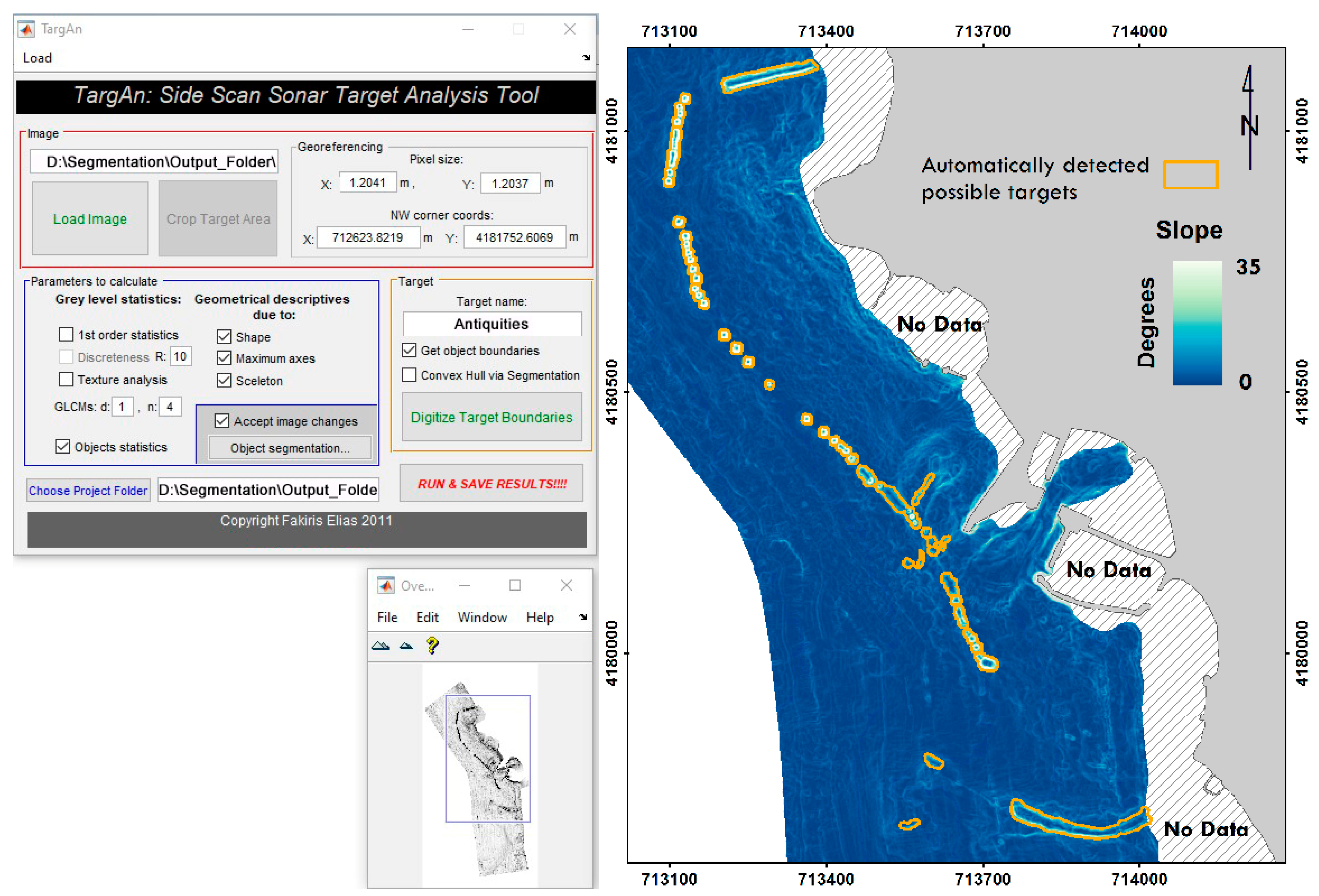
- Fakiris, E.; Papatheodorou, G. Quantification of regions of interest in swath sonar backscatter images using grey-level and shape geometry descriptors: The TargAn software. Mar. Geophys. Res. 2012, 33, 169–183. [Google Scholar] [CrossRef]
- Ullman, S. The Interpretation of Structure from Motion. Proc. R. Soc. London. Ser. B Biol. Sci. 1979, 203, 405–426. [Google Scholar]
- Casella, E.; Rovere, A.; Pedroncini, A.; Stark, C.P.; Casella, M.; Ferrari, M.; Firpo, M. Drones as tools for monitoring beach topography changes in the Ligurian Sea (NW Mediterranean). Geo-Mar. Lett. 2016, 36, 151–163. [Google Scholar] [CrossRef]
- Drap, P.; Papini, O.; Merad, D.; Pasquet, J.; Royer, J.P.; Motasem Nawaf, M.; Saccone, M.; Ben Ellefi, M.; Chemisky, B.; Seinturier, J.; et al. Deepwater Archaeological Survey: An Interdisciplinary and Complex Process. Coast. Res. Libr. 2019, 31, 135–153. [Google Scholar] [CrossRef] [Green Version]
- Mattei, G.; Rizzo, A.; Anfuso, G.; Aucelli, P.P.C.; Gracia, F.J. A tool for evaluating the archaeological heritage vulnerability to coastal processes: The case study of Naples Gulf (southern Italy). Ocean Coast. Manag. 2019, 179, 104876. [Google Scholar] [CrossRef]
- Aucelli, P.P.C.; Mattei, G.; Caporizzo, C.; Cinque, A.; Troisi, S.; Peluso, F.; Stefanile, M.; Pappone, G. Ancient coastal changes due to ground movements and human interventions in the roman portus julius (Pozzuoli Gulf, Italy): Results from photogrammetric and direct surveys. Water 2020, 12, 658. [Google Scholar] [CrossRef] [Green Version]
- Walbridge, S.; Slocum, N.; Pobuda, M.; Wright, D.J. Unified Geomorphological Analysis Workflows with Benthic Terrain Modeler. Geosciences 2018, 8, 94. [Google Scholar] [CrossRef] [Green Version]
- Fakiris, E.; Zoura, D.; Ramfos, A.; Spinos, E.; Georgiou, N.; Ferentinos, G.; Papatheodorou, G. Object-based classification of sub-bottom profiling data for benthic habitat mapping. Comparison with sidescan and RoxAnn in a Greek shallow-water habitat. Estuar. Coast. Shelf Sci. 2018, 208, 219–234. [Google Scholar] [CrossRef]
- Fakiris, E.; Blondel, P.; Papatheodorou, G.; Christodoulou, D.; Dimas, X.; Georgiou, N.; Kordella, S.; Dimitriadis, C.; Rzhanov, Y.; Geraga, M.; et al. Multi-frequency, multi-sonar mapping of shallow habitats-efficacy and management implications in the National Marine Park of Zakynthos, Greece. Remote Sens. 2019, 11, 461. [Google Scholar] [CrossRef] [Green Version]
- Liu, B.; Liu, Z.; Men, S.; Li, Y.; Ding, Z.; He, J.; Zhao, Z. Underwater Hyperspectral Imaging Technology and Its Applications for Detecting and Mapping the Seafloor: A Review. Sensors 2020, 20, 4962. [Google Scholar] [CrossRef]
- Rovere, A.; Stocchi, P.; Vacchi, M. Eustatic and Relative Sea Level Changes. Curr. Clim. Chang. Rep. 2016, 2, 221–231. [Google Scholar] [CrossRef] [Green Version]
- Benjamin, J.; Rovere, A.; Fontana, A.; Furlani, S.; Vacchi, M.; Inglis, R.H.; Galili, E.; Antonioli, F.; Sivan, D.; Miko, S.; et al. Late Quaternary sea-level changes and early human societies in the central and eastern Mediterranean Basin: An interdisciplinary review. Quat. Int. 2017, 449, 29–57. [Google Scholar] [CrossRef] [Green Version]
- Vona, I.; Gray, M.W.; Nardin, W. The impact of submerged breakwaters on sediment distribution along marsh boundaries. Water 2020, 12, 1016. [Google Scholar] [CrossRef] [Green Version]
- Na’Im, I.I.; Shahrizal, A.R.M.; Safari, M.D. A Short Review of Submerged Breakwaters. MATEC Web Conf. 2018, 203, 1–17. [Google Scholar] [CrossRef]
- Hanson, S.; Nicholls, R.; Zanuttigh, B. Case Studies Worldwide: Introduction; Butterworth-Heinemann: Oxford, UK, 2014; ISBN 9780123973313. [Google Scholar] [CrossRef]
- Sabdono, P.; Parmantoro, P.N. Design of Submerged Breakwater. Media Komun. Tek. Sipil 2014, 12, 1–11. [Google Scholar] [CrossRef]
- Kubowicz-Grajewska, A. Morpholithodynamical changes of the beach and the nearshore zone under the impact of submerged breakwaters—A case study (Orłowo Cliff, the Southern Baltic). Oceanologia 2015, 57, 144–158. [Google Scholar] [CrossRef] [Green Version]
- Papatheodorou, G.; Geraga, M.; Chalari, A.; Christodoulou, D.; Iatrou, M.; Ferentinos, G. Hellenistic Alexandria: A palaeogeographic reconstruction based on marine geophysical data. In Alexandria under the Mediterranean; Centre d’etudes Alexandrines: Alexandria, Egypt, 2015. [Google Scholar]
- Vött, A. Silting up Oiniadai’s harbours (Acheloos River delta, NW Greece). Geoarchaeological implications of late Holocene landscape changes. Géomorphologie Reli. Process. Environ. 2009, 13. [Google Scholar] [CrossRef] [Green Version]
- Morhange, C.; Pirazzoli, P.A.; Evelpidou, N.; Marriner, N. Late holocene tectonic uplift and the silting up of lechaion, the western harbor of ancient Corinth, Greece. Geoarchaeology 2012, 27, 278–283. [Google Scholar] [CrossRef]
- Graauw, A.D. Ancient port structures: An engineer’s perspective. In Proceedings of the PortusLimen Conference, Rome, Italy, 29–30 January 2019. [Google Scholar]
- Morhange, C.; Marriner, N. The Ecohistory of Ancient Harbours. 2013. Available online: https://www.ancientportsantiques.com/wp-content/uploads/Documents/AUTHORS/Morhange-PublGenerales/Morhange2016-HistoryPorts.pdf (accessed on 23 August 2021).
- Baika, K. Archaeological indicators of relative sea-level changes in the Attico-Cycladic massif since Classical antiquity: Preliminary results. Bull. Geol. Soc. Greece 2008, 42, 33–48. [Google Scholar]
- Poulos, S.E.; Ghionis, G.; Maroukian, H. Sea-level rise trends in the Attico-Cycladic region (Aegean Sea) during the last 5000 years. Geomorphology 2009, 107, 10–17. [Google Scholar] [CrossRef]
- Baika, K. The fortification of shipsheds and naval arsenals. In Shipsheds in the Ancient Mediterranean; Blackman, D., Rankov, B., Baika, K., Gerding, H., Pakkanen, J., Eds.; Cambridge University Press: Cambridge, UK, 2013; pp. 210–230. [Google Scholar]
- Baika, K. Ancient harbour cities—New methodological perspectives and recent research in Greece. In Byzas 19—Harbors and Harbor Cities in the Eastern Mediterranean from Antiquity to the Byzantine Period: Recent Discoveries and Current Approaches in Proceedings of the Int. Symposium (DAI), BYZAS 19; Ladstatter; Öster-reichisches Archäologisches Institut Sonder: Vienna, Austria, 2015; Volume 2, pp. 445–491. [Google Scholar]
- Khakzad, S.; Pieters, M.; Van Balen, K. Coastal cultural heritage: A resource to be included in integrated coastal zone management. Ocean Coast. Manag. 2015, 118, 110–128. [Google Scholar] [CrossRef]


Publisher’s Note: MDPI stays neutral with regard to jurisdictional claims in published maps and institutional affiliations. |
© 2021 by the authors. Licensee MDPI, Basel, Switzerland. This article is an open access article distributed under the terms and conditions of the Creative Commons Attribution (CC BY) license (https://creativecommons.org/licenses/by/4.0/).
Share and Cite
Georgiou, N.; Dimas, X.; Fakiris, E.; Christodoulou, D.; Geraga, M.; Koutsoumpa, D.; Baika, K.; Kalamara, P.; Ferentinos, G.; Papatheodorou, G. A Multidisciplinary Approach for the Mapping, Automatic Detection and Morphometric Analysis of Ancient Submerged Coastal Installations: The Case Study of the Ancient Aegina Harbour Complex. Remote Sens. 2021, 13, 4462. https://doi.org/10.3390/rs13214462
Georgiou N, Dimas X, Fakiris E, Christodoulou D, Geraga M, Koutsoumpa D, Baika K, Kalamara P, Ferentinos G, Papatheodorou G. A Multidisciplinary Approach for the Mapping, Automatic Detection and Morphometric Analysis of Ancient Submerged Coastal Installations: The Case Study of the Ancient Aegina Harbour Complex. Remote Sensing. 2021; 13(21):4462. https://doi.org/10.3390/rs13214462
Chicago/Turabian StyleGeorgiou, Nikos, Xenophon Dimas, Elias Fakiris, Dimitris Christodoulou, Maria Geraga, Despina Koutsoumpa, Kalliopi Baika, Pari Kalamara, George Ferentinos, and George Papatheodorou. 2021. "A Multidisciplinary Approach for the Mapping, Automatic Detection and Morphometric Analysis of Ancient Submerged Coastal Installations: The Case Study of the Ancient Aegina Harbour Complex" Remote Sensing 13, no. 21: 4462. https://doi.org/10.3390/rs13214462
APA StyleGeorgiou, N., Dimas, X., Fakiris, E., Christodoulou, D., Geraga, M., Koutsoumpa, D., Baika, K., Kalamara, P., Ferentinos, G., & Papatheodorou, G. (2021). A Multidisciplinary Approach for the Mapping, Automatic Detection and Morphometric Analysis of Ancient Submerged Coastal Installations: The Case Study of the Ancient Aegina Harbour Complex. Remote Sensing, 13(21), 4462. https://doi.org/10.3390/rs13214462