
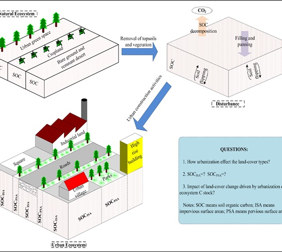
Urban Land-Cover Change and Its Impact on the Ecosystem Carbon Storage in a Dryland City


Abstract
:
1. Introduction
2. Experimental Section
2.1. Study Area

2.2. Remote Sensing Data
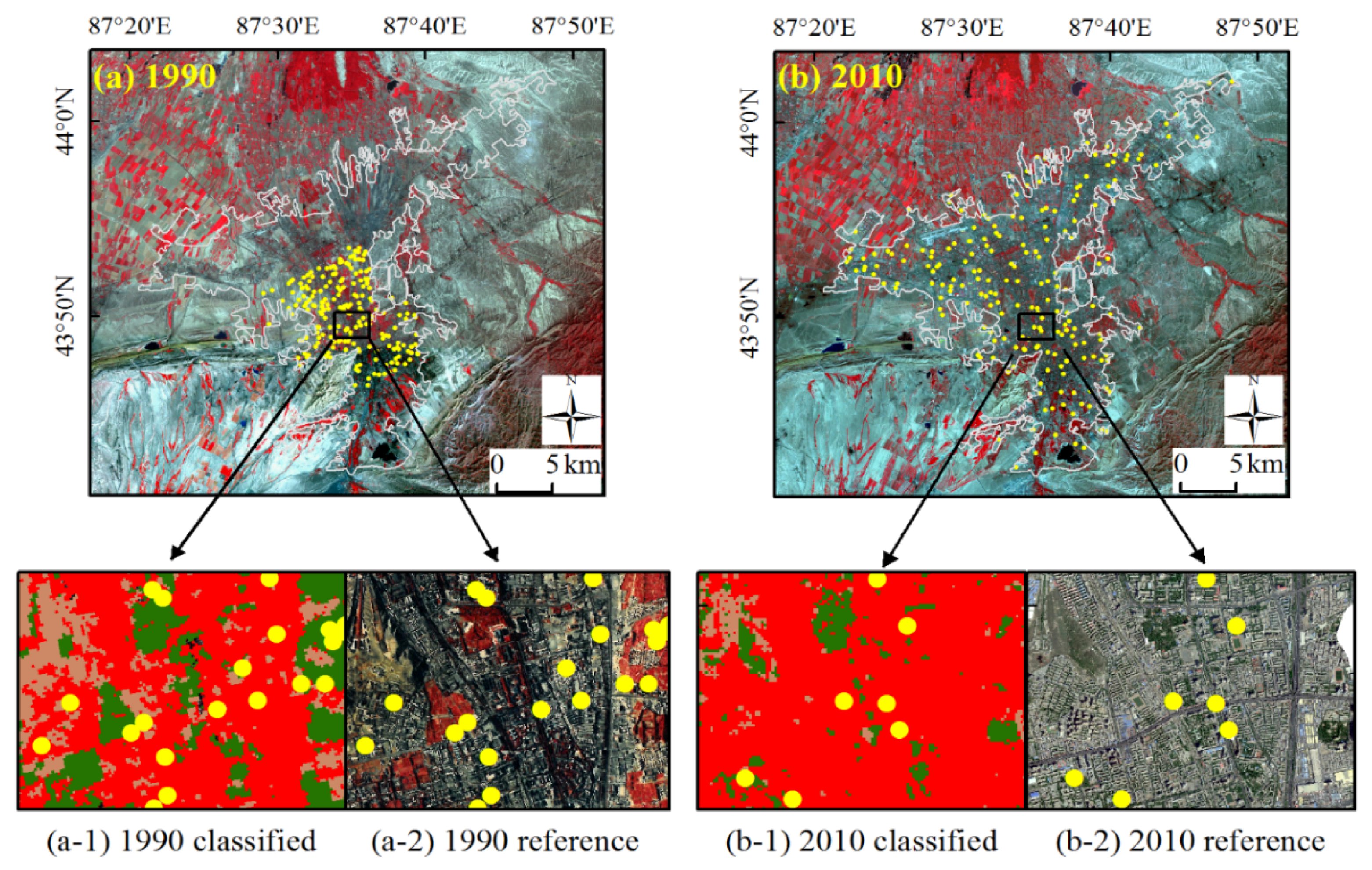
2.3. Urban Land Cover Mapping


| Year | Classified Data | Reference Data | Reference Totals | Classified Totals | Number Correct | Producer’s Accuracy | User’s Accuracy | ||||
|---|---|---|---|---|---|---|---|---|---|---|---|
| Water | ISA | Urban Greenspace | Remnant Desert/Bare Soil | Cropland | |||||||
| 1990 | Water | 3 | 0 | 0 | 0 | 0 | 3 | 3 | 3 | 100.0% | 100.0% |
| ISA | 0 | 73 | 0 | 9 | 0 | 83 | 82 | 73 | 88% | 89.0% | |
| Urban greenspace | 0 | 0 | 41 | 0 | 0 | 42 | 41 | 41 | 97.6% | 100.0% | |
| Remnant desert/bare soil | 0 | 10 | 1 | 60 | 0 | 69 | 71 | 60 | 87% | 84.5% | |
| Cropland | 0 | 0 | 0 | 0 | 3 | 3 | 3 | 3 | 100.0% | 100.0% | |
| Overall Classification Accuracy = 90% (i.e., 180/200), Overall Kappa Statistics = 0.849 | |||||||||||
| 2010 | Water | 2 | 0 | 0 | 0 | 0 | 2 | 2 | 2 | 100.0% | 100.0% |
| ISA | 0 | 114 | 0 | 6 | 0 | 124 | 120 | 114 | 91.9% | 95.0% | |
| Urban greenspace | 0 | 0 | 30 | 0 | 0 | 30 | 30 | 30 | 100.0% | 100.0% | |
| Remnant desert/bare soil | 0 | 10 | 0 | 34 | 0 | 40 | 44 | 34 | 85.0% | 77.3% | |
| Cropland | 0 | 0 | 0 | 0 | 4 | 4 | 4 | 4 | 100.0% | 100.0% | |
| Overall Classification Accuracy = 92% (i.e., 184/200), Overall Kappa Statistics = 0.857 | |||||||||||
2.4. Landscape Pattern Analysis
| Landscape Indexes | Equation | Description |
|---|---|---|
| Number of patches (NP) | It is a simple measure of the extent of subdivision or fragmentation of the patch type. | |
| (ni = number of patches in the landscape of patch type (class) i. | ||
| Largest patch index (LPI) | It is a simple measure of dominance. | |
| (ai = area (m2) of patch i, A = total landscape area (m2).) | ||
| Landscape shape index (LSI) | It provides a standardized measure of total edge or edge density that adjusts for the size of the landscape. LSI increases without limit as landscape shape becomes more irregular and/or as the length of edge within the landscape increases. | |
| (E = total length (m) of edge in landscape, A = total landscape area (m2).) | ||
| Contagion index (CONTAG) | It measures the degree of clumping of different patches in a landscape. | |
| (n = number of the patch types, PiJ. = the proportions of different attribute adjacency types i and j.) | ||
| Shannon’s diversity index (SHDI) | It is a popular measure of diversity in community ecology, applied here to landscapes. | |
| (Pi = proportion of the landscape occupied by patch type (class) i.) |
2.5. Assessing the Urbanization Effects on Ecosystem C Stock in Urumqi
| Site ID | Longitude (DD) | Latitude (DD) | Elevation (m) | Soil Type | Land-Use Type | ISA Type | PSA Type | ISA | PSA |
|---|---|---|---|---|---|---|---|---|---|
| SOCDISA (kg·C·m−2) | SOCDPSA (kg·C·m−2) | ||||||||
| 1 | 87.65 | 43.84 | 826 | Solonetzs | Industrial | Street | Street tree | 5.75 | 9.90 |
| 2 | 87.48 | 43.87 | 725 | Solonetzs | Industrial | Street | Street tree | 3.66 | 2.40 |
| 3 | 87.56 | 43.86 | 769 | Solonetzs | Institutional | Street | Street tree | 2.15 | 10.00 |
| 4 | 87.53 | 43.86 | 797 | Castanozems | Commercial | Parking lot | Urban woodland | 6.10 | 8.06 |
| 5 | 87.54 | 43.84 | 816 | Castanozems | Transportation | Highway | Urban lawn | 8.03 | 10.30 |
| 6 | 87.56 | 43.82 | 853 | Castanozems | Industrial | Street | Street tree | 4.44 | 8.12 |
| 7 | 87.56 | 43.80 | 879 | Castanozems | Transportation | Highway | Urban lawn | 5.44 | 8.08 |
| 8 | 87.60 | 43.79 | 887 | Unavailable | Commercial | Street | Street tree | 5.28 | 4.03 |
| 9 | 87.57 | 43.87 | 765 | Solonetzs | Commercial | Street | Street tree | 7.64 | 8.29 |
| 10 | 87.64 | 43.97 | 591 | Solonetzs | Residential | Paved backyard | Residential green space | 4.35 | 11.72 |
| 11 | 87.66 | 43.96 | 613 | Solonetzs | Residential | paved backyard | Residential green space | 6.16 | 7.97 |
3. Results
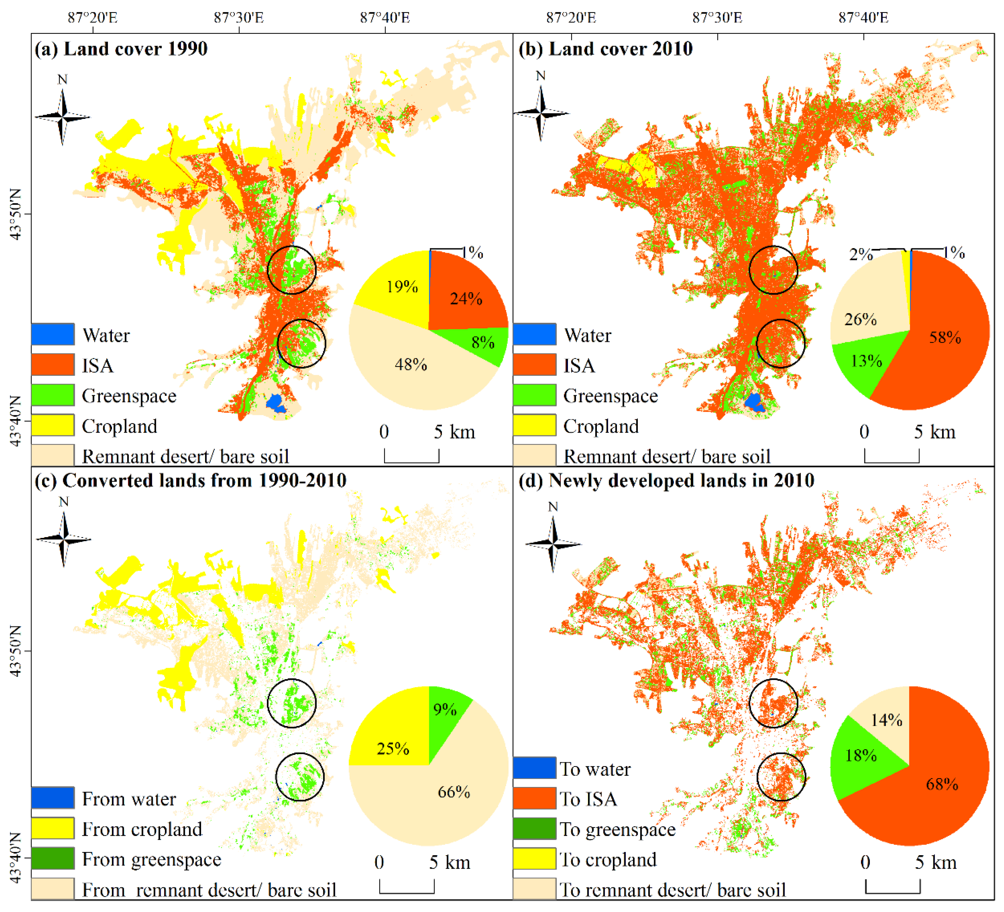
3.1. The Areas and Distribution of Major Land-Cover Types
| 2010 | Water Body | ISA | Urban Greenspace | Remnant Desert/Bare Soil | Cropland | 1990 Total | |
|---|---|---|---|---|---|---|---|
| 1990 | |||||||
| Water body | 2.15 | 0 | 0.24 | 0 | 0 | 2.39 | |
| ISA | 0 | 90.45 | 0 | 0 | 0 | 90.45 | |
| Urban greenspace | 0.05 | 15.32 | 16.37 | 0 | 0 | 31.74 | |
| Remnant desert/bare soil | 0 | 81.01 | 26.75 | 72.79 | 0 | 180.55 | |
| Cropland | 0 | 33.05 | 7.74 | 26.84 | 6.96 | 74.59 | |
| 2010 Total | 2.20 | 219.83 | 51.10 | 99.63 | 6.96 | 379.72 | |

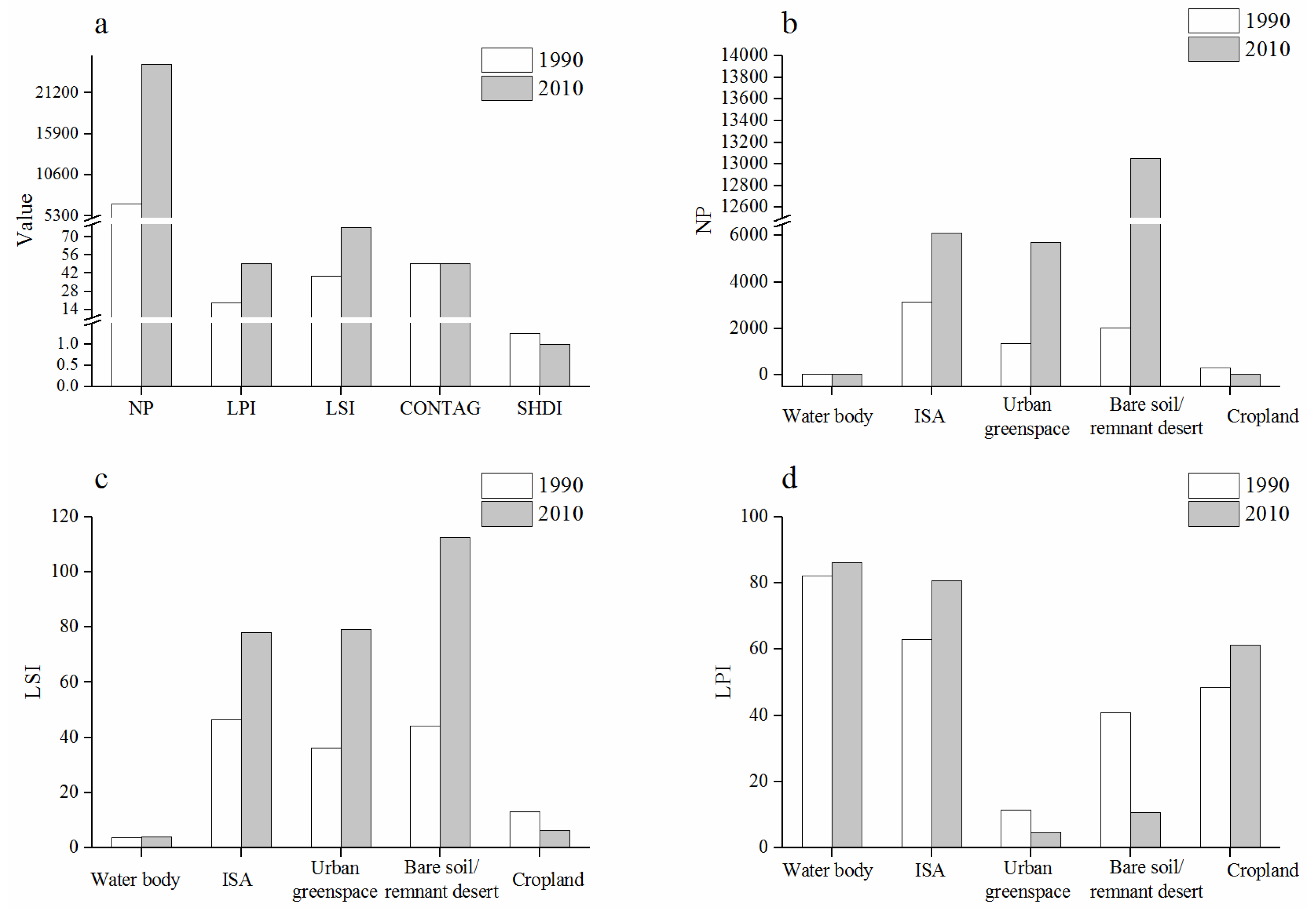
3.2. Changes in the Landscape Pattern from 1990 to 2010

3.3. The Land Conversions during 1990–2010
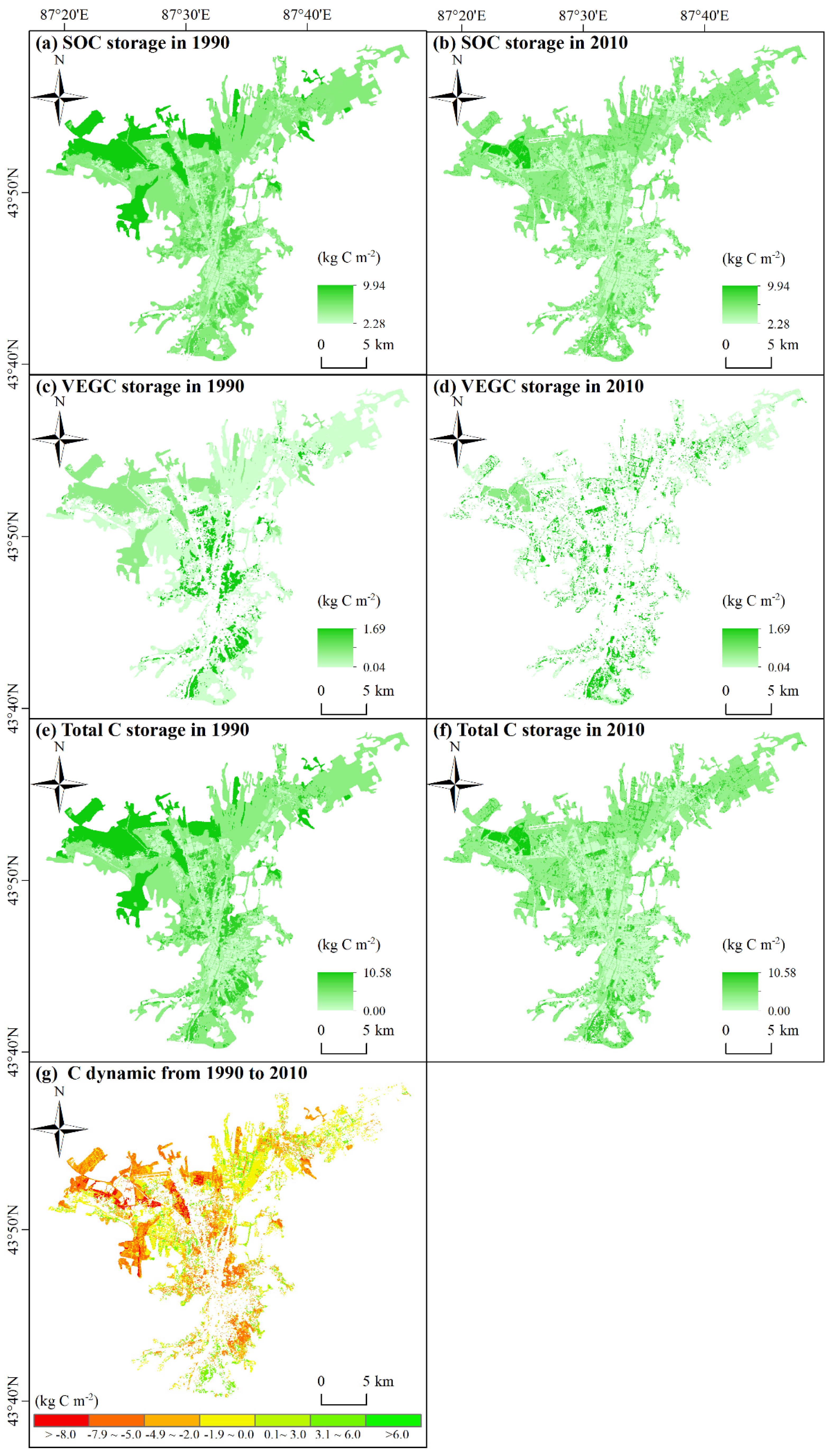
3.4. The Ecosystem C Dynamic and Its Spatiotemporal Pattern
| Land-Cover Types | VEGC ± SE (kg·C·m−2) | SOCD ± SE (kg·C·m−2) | TOTEC (kg·C·m−2) | Source |
|---|---|---|---|---|
| Urban impervious surface | NA | 5.36 ± 0.51 (N = 11) | 5.36 | This study |
| Urban greenspaces | 1.69 ± 0.65 (N = 45) | 8.08 ± 0.82 (N = 11) | 9.77 | [57] & This study |
| Cropland | 0.64 ± 0.21 (N = 17) | 9.94 ± 0.56 (N = 14) | 10.58 | [56,58] |
| Remnant desert/bare soil | 0.04 ± 0.03 (N = 10) | 5.55 ± 0.60 (N = 10) | 5.59 | [56,58] |
| Land-Cover Type | 1990 | 2010 | 2010–1990 | ||||||
|---|---|---|---|---|---|---|---|---|---|
| SOC | VEGC | Sum | SOC | VEGC | Sum | SOC | VEGC | Sum | |
| ISA | 0.336 | 0 | 0.336 | 0.877 | 0 | 0.877 | 0.540 | 0 | 0.540 |
| Urban greenspace | 0.263 | 0.055 | 0.318 | 0.371 | 0.078 | 0.449 | 0.108 | 0.023 | 0.131 |
| Remnant desert/bare soil | 0.992 | 0.007 | 1.000 | 0.496 | 0.004 | 0.500 | −0.496 | −0.004 | −0.500 |
| Cropland | 0.644 | 0.041 | 0.686 | 0.070 | 0.004 | 0.074 | −0.575 | −0.037 | −0.612 |
| Total | 2.236 | 0.104 | 2.340 | 1.814 | 0.086 | 1.899 | −0.423 | −0.018 | −0.441 |

4. Discussion
5. Conclusions
Supplementary Materials
Acknowledgments
Author Contributions
Conflicts of Interest
References
- Seto, K.C.; Guneralp, B.; Hutyra, L.R. Global forecasts of urban expansion to 2030 and direct impacts on biodiversity and carbon pools. Proc. Natl. Acad. Sci. USA 2012, 109, 16083–16088. [Google Scholar] [CrossRef] [PubMed]
- Svirejeva-Hopkins, A.; Schellnhuber, H.J.; Pomaz, V.L. Urbanised territories as a specific component of the global carbon cycle. Ecol. Model. 2004, 173, 295–312. [Google Scholar] [CrossRef]
- Seto, K.C.; Fragkias, M.; Guneralp, B.; Reilly, M.K. A meta-analysis of global urban land expansion. PLoS ONE 2011, 6. [Google Scholar] [CrossRef] [PubMed]
- Schneider, A. Monitoring land cover change in urban and pen-urban areas using dense time stacks of landsat satellite data and a data mining approach. Remote Sens. Environ. 2012, 124, 689–704. [Google Scholar] [CrossRef]
- Nowak, D.J.; Crane, D.E. Carbon storage and sequestration by urban trees in the USA. Environ. Pollut. 2002, 116, 381–389. [Google Scholar] [CrossRef]
- Pataki, D.E.; Alig, R.J.; Fung, A.S.; Golubiewski, N.E.; Kennedy, C.A.; McPherson, E.G.; Nowak, D.J.; Pouyat, R.V.; Lankao, P.R. Urban ecosystems and the north american carbon cycle. Glob. Chang. Biol. 2006, 12, 2092–2102. [Google Scholar] [CrossRef]
- Pouyat, R.V.; Yesilonis, I.D.; Nowak, D.J. Carbon storage by urban soils in the united states. J. Environ. Qual. 2006, 35, 1566–1575. [Google Scholar] [CrossRef] [PubMed]
- Churkina, G.; Brown, D.G.; Keoleian, G. Carbon stored in human settlements: The conterminous united states. Glob. Chang. Biol. 2010, 16, 135–143. [Google Scholar] [CrossRef]
- Davies, Z.G.; Edmondson, J.L.; Heinemeyer, A.; Leake, J.R.; Gaston, K.J. Mapping an urban ecosystem service: Quantifying above-ground carbon storage at a city-wide scale. J. Appl. Ecol. 2011, 48, 1125–1134. [Google Scholar] [CrossRef]
- Hutyra, L.R.; Yoon, B.; Alberti, M. Terrestrial carbon stocks across a gradient of urbanization: A study of the seattle, wa region. Glob. Chang. Biol. 2011, 17, 783–797. [Google Scholar] [CrossRef]
- Edmondson, J.L.; Davies, Z.G.; McHugh, N.; Gaston, K.J.; Leake, J.R. Organic carbon hidden in urban ecosystems. Sci. Rep. 2012, 2. [Google Scholar] [CrossRef] [PubMed]
- Grimm, N.B.; Faeth, S.H.; Golubiewski, N.E.; Redman, C.L.; Wu, J.G.; Bai, X.M.; Briggs, J.M. Global change and the ecology of cities. Science 2008, 319, 756–760. [Google Scholar] [CrossRef] [PubMed]
- Trusilova, K.; Churkina, G. The response of the terrestrial biosphere to urbanization: Land cover conversion, climate, and urban pollution. Biogeosciences 2008, 5, 1505–1515. [Google Scholar] [CrossRef]
- Bae, J.; Ryu, Y. Land use and land cover changes explain spatial and temporal variations of the soil organic carbon stocks in a constructed urban park. Landsc. Urban Plan. 2015, 136, 57–67. [Google Scholar] [CrossRef]
- Nowak, D.J. Institutionalizing urban forestry as a “biotechnology” to improve environmental quality. Urban For. Urban Green. 2006, 5, 93–100. [Google Scholar] [CrossRef]
- Tratalos, J.; Fuller, R.A.; Warren, P.H.; Davies, R.G.; Gaston, K.J. Urban form, biodiversity potential and ecosystem services. Landsc. Urban Plan. 2007, 83, 308–317. [Google Scholar] [CrossRef]
- Lopez, E.; Bocco, G.; Mendoza, M.; Duhau, E. Predicting land-cover and land-use change in the urban fringe—A case in morelia city, mexico. Landsc. Urban Plan. 2001, 55, 271–285. [Google Scholar] [CrossRef]
- Haregeweyn, N.; Fikadu, G.; Tsunekawa, A.; Tsubo, M.; Meshesha, D.T. The dynamics of urban expansion and its impacts on land use/land cover change and small-scale farmers living near the urban fringe: A case study of Bahir Dar, Ethiopia. Landsc. Urban Plan. 2012, 106, 149–157. [Google Scholar] [CrossRef]
- Fu, Y.C.; Lu, X.Y.; Zhao, Y.L.; Zeng, X.T.; Xia, L.L. Assessment impacts of weather and land use/land cover (LULC) change on urban vegetation net primary productivity (NPP): A case study in Guangzhou, China. Remote Sens. 2013, 5, 4125–4144. [Google Scholar] [CrossRef]
- Dadras, M.; Shafri, H.Z.M.; Ahmad, N.; Pradhan, B.; Safarpour, S. Land use/cover change detection and urban sprawl analysis in bandar abbas city, Iran. Sci. World J. 2014. [Google Scholar] [CrossRef] [PubMed]
- Kuang, W.H.; Liu, J.Y.; Zhang, Z.X.; Lu, D.S.; Xiang, B. Spatiotemporal dynamics of impervious surface areas across china during the early 21st century. Chin. Sci. Bull. 2013, 58, 1691–1701. [Google Scholar] [CrossRef]
- Raciti, S.M.; Hutyra, L.R.; Finzi, A.C. Depleted soil carbon and nitrogen pools beneath impervious surfaces. Environ. Pollut. 2012, 164, 248–251. [Google Scholar] [CrossRef] [PubMed]
- Bell, M.J.; Worrall, F.; Smith, P.; Bhogal, A.; Black, H.; Lilly, A.; Barraclough, D.; Merrington, G. UK land-use change and its impact on SOC: 1925–2007. Glob. Biogeochem. Cycles 2011, 25, GB4015. [Google Scholar] [CrossRef]
- Tomlinson, R.W.; Milne, R.M. Soil carbon stocks and land cover in northern ireland from 1939 to 2000. Appl. Geogr. 2006, 26, 18–39. [Google Scholar] [CrossRef]
- Cannell, M.G.R.; Milne, R.; Hargreaves, K.J.; Brown, T.A.W.; Cruickshank, M.M.; Bradley, R.I.; Spencer, T.; Hope, D.; Billett, M.F.; Adger, W.N.; et al. National inventories of terrestrial carbon sources and sinks: The uk experience. Clim. Chang. 1999, 42, 505–530. [Google Scholar] [CrossRef]
- Schaldach, R.; Alcamo, J. Simulating the effects of urbanization, afforestation and cropland abandonment on a regional carbon balance: A case study for central Germany. Reg. Environ. Chang. 2007, 7, 137–148. [Google Scholar] [CrossRef]
- Wei, Z.Q.; Wu, S.H.; Yan, X.; Zhou, S.L. Density and stability of soil organic carbon beneath impervious surfaces in urban areas. PLoS ONE 2014, 9. [Google Scholar] [CrossRef] [PubMed]
- Lal, R. Carbon sequestration in dryland ecosystems. Environ. Manag. 2004, 33, 528–544. [Google Scholar] [CrossRef] [PubMed]
- Urumqi Bureau of Statistics. Available online: http://www.wlmqtj.gov.cn/ (accessed on 16 December 2015).
- Statistics bureau of Xinjiang Uygur Autonomous region. Xinjiang Statistical Yearbook; China Statistics Press: Beijing, China, 2013.
- Yu, D.S.; Shi, X.Z.; Sun, W.X.; Wang, H.J.; Liu, Q.H.; Zhao, Y.C. Estimation of china soil organic carbon storage and density based on 1:1,000,000 soil database. Chin. J. Appl. Ecol. 2005, 16, 2279–2283. [Google Scholar]
- Lu, D.; Li, G.; Moran, E. Current situation and needs of change detection techniques. Int. J. Image Data Fusion 2014, 5, 13–38. [Google Scholar] [CrossRef]
- Lu, D.S.; Weng, Q.H. Spectral mixture analysis of the urban landscape in indianapolis with landsat ETM plus imagery. Photogramm. Eng. Remote Sens. 2004, 70, 1053–1062. [Google Scholar] [CrossRef]
- Lu, D.S.; Weng, Q.H. Use of impervious surface in urban land-use classification. Remote Sens. Environ. 2006, 102, 146–160. [Google Scholar] [CrossRef]
- Zhang, C.; Tian, H.Q.; Chen, G.S.; Chappelka, A.; Xu, X.F.; Ren, W.; Hui, D.F.; Liu, M.L.; Lu, C.Q.; Pan, S.F.; et al. Impacts of urbanization on carbon balance in terrestrial ecosystems of the southern United States. Environ. Pollut. 2012, 164, 89–101. [Google Scholar] [CrossRef] [PubMed]
- Ross, S.; Bhadauria, H.S. A review of change detection techniques of landcover using remote sensing data. IOSR J. Comput. Eng. 2015, 17, 17–21. [Google Scholar]
- Jensen, J.R. Introductory Digital Image Processing: A Remote Sensing Perspective, 3rd ed.; Prentice Hall: Upper Saddle River, NJ, USA, 2005. [Google Scholar]
- Alphan, H.; Doygun, H.; Unlukaplan, Y.I. Post-classification comparison of land cover using multitemporal landsat and aster imagery: The case of kahramanmara angstrom, turkey. Environ. Monit. Assess. 2009, 151, 327–336. [Google Scholar] [CrossRef] [PubMed]
- Ahlqvist, O. Extending post-classification change detection using semantic similarity metrics to overcome class heterogeneity: A study of 1992 and 2001 us national land cover database changes. Remote Sens. Environ. 2008, 112, 1226–1241. [Google Scholar] [CrossRef]
- McRoberts, R.E. Post-classification approaches to estimating change in forest area using remotely sensed auxiliary data. Remote Sens. Environ. 2014, 151, 149–156. [Google Scholar] [CrossRef]
- Peiman, R. Pre-classification and post-classification change-detection techniques to monitor land-cover and land-use change using multi-temporal landsat imagery: A case study on pisa province in italy. Int. J. Remote Sens. 2011, 32, 4365–4381. [Google Scholar] [CrossRef]
- Lu, D.S.; Moran, E.; Hetrick, S. Detection of impervious surface change with multitemporal landsat images in an urban-rural frontier. ISPRS J. Photogramm. 2011, 66, 298–306. [Google Scholar] [CrossRef] [PubMed]
- Adams, J.B.; Sabol, D.E.; Kapos, V.; Almeida, R.; Roberts, D.A.; Smith, M.O.; Gillespie, A.R. Classification of multispectral images based on fractions of endmembers—Application to land-cover change in the brazilian amazon. Remote Sens. Environ. 1995, 52, 137–154. [Google Scholar] [CrossRef]
- Ridd, M.K. Exploring a V-I-S (vegetation-impervious surface-soil) model for urban ecosystem analysis through remote sensing: Comparative anatomy for cities. Int. J. Remote Sens. 1995, 16, 2165–2185. [Google Scholar] [CrossRef]
- Wu, C.S.; Murray, A.T. Estimating impervious surface distribution by spectral mixture analysis. Remote Sens. Environ. 2003, 84, 493–505. [Google Scholar] [CrossRef]
- Zhang, C.; Chen, Y.L.; Lu, D.S. Mapping land-cover distribution in arid/semiarid urban landscapes with landsat thematic mapper imagery. Int. J. Remote Sens. 2015, 36, 4483–4500. [Google Scholar] [CrossRef]
- Liu, J.Y.; Zhang, Z.X.; Xu, X.L.; Kuang, W.H.; Zhou, W.C.; Zhang, S.W.; Li, R.D.; Yan, C.Z.; Yu, D.S.; Wu, S.X.; et al. Spatial patterns and driving forces of land use change in China during the early 21st century. J. Geogr. Sci. 2010, 20, 483–494. [Google Scholar] [CrossRef]
- Stehman, S.V. Impact of sample size allocation when using stratified random sampling to estimate accuracy and area of land-cover change. Remote Sens. Lett. 2012, 3, 111–120. [Google Scholar] [CrossRef]
- Congalton, R.G. A review of assessing the accuracy of classifications of remotely sensed data. Remote Sens. Environ. 1991, 37, 35–46. [Google Scholar] [CrossRef]
- Smits, P.C.; Dellepiane, S.G.; Schowengerdt, R.A. Quality assessment of image classification algorithms for land-cover mapping: A review and a proposal for a cost-based approach. Int. J. Remote Sens. 1999, 20, 1461–1486. [Google Scholar] [CrossRef]
- Foody, G.M. Status of land cover classification accuracy assessment. Remote Sens. Environ. 2002, 80, 185–201. [Google Scholar] [CrossRef]
- Stehman, S.V. Model-assisted estimation as a unifying framework for estimating the area of land cover and land-cover change from remote sensing. Remote Sens. Environ. 2009, 113, 2455–2462. [Google Scholar] [CrossRef]
- Czaplewski, R.L.; Catts, G.P. Calibration of remotely sensed proportion or area estimates for misclassification error. Remote Sens. Environ. 1992, 39, 29–43. [Google Scholar] [CrossRef]
- Fragstats v4: Spatial Pattern Analysis Program for Categorical and Continuous Maps. Available online: http://www.umass.edu/landeco/research/fragstats/fragstats.html (accessed on 16 December 2015).
- Black, C.A.; Evans, D.D.; Ensminger, L.E.; White, J.L.; Clark, F.E. Methods of Soil Analysis. Part 2. Chemical and Microbiological Properties; American Society of Agronomy, Soil Science Society of America: Madison, WI, USA, 1965. [Google Scholar]
- Shi, X.Z.; Yu, D.S.; WArner, E.D.; Pan, X.Z.; Petersen, G.W.; Gong, Z.T.; Weindorf, D.C. Soil database of 1:1,000,000 digital soil survey and reference system of the chinese genetic soil classification system. Soil Surv. Horiz. 2004, 45, 129–136. [Google Scholar] [CrossRef]
- Yan, S. Vegetation Structure Characteristics and Carbon Uptake of Urban Built-Up Area in China; Zhejiang University: Hangzhou, China, 2013. [Google Scholar]
- Chen, Y.L.; Luo, G.P.; Ye, H.; Zhao, S.B.; Wang, Y.G.; Han, Q.F. Sources and sinks of carbon from forest land use change in xinjiang, china during 1975–2005. Geogr. Res. 2013, 32, 1987–1999. [Google Scholar]
- Pouyat, R.; Pataki, D.; Belt, K.; Groffman, P.; Hom, J.; Band, L. Effects of urban land-use change on biogeochemical cycles. In Terrestrial Ecosystems in a Changing World; Canadell, J., Pataki, D., Pitelka, L., Eds.; Springer: Berlin, Germany; Heidelberg, Germany, 2007; pp. 45–58. [Google Scholar]
- Ju, R.T.; Li, B. A risk analysis system for alien species in urban green spaces and application to the 2010 expo, Shanghai. Biodivers. Sci. 2012, 20, 12–23. [Google Scholar]
- Steiner, F. Urban landscape perspectives. Land 2014, 3, 342–350. [Google Scholar] [CrossRef]
- Chen, Y.J.; Day, S.D.; Wick, A.F.; Strahm, B.D.; Wiseman, P.E.; Daniels, W.L. Changes in soil carbon pools and microbial biomass from urban land development and subsequent post-development soil rehabilitation. Soil Biol. Biochem. 2013, 66, 38–44. [Google Scholar] [CrossRef]
- Zhang, C.; Tian, H.; Pan, S.; Lockaby, G.; Chappelka, A. Multi-factor controls on terrestrial carbon dynamics in urbanized areas. Biogeosciences 2014, 11, 7107–7124. [Google Scholar] [CrossRef]
- Poudyal, N.C.; Siry, J.P.; Bowker, J.M. Urban forests’ potential to supply marketable carbon emission offsets: A survey of municipal governments in the United States. For. Policy Econ. 2010, 12, 432–438. [Google Scholar] [CrossRef]
- Wu, J.G. Toward a landscape ecology of cities: Beyond buildings, trees, and urban forests. In Ecology, Planning, and Management of Urban Forests; Springer: Berlin, Germany; Heidelberg, Germany, 2008; pp. 10–28. [Google Scholar]
- Stein, A.; Ettema, C. An overview of spatial sampling procedures and experimental design of spatial studies for ecosystem comparisons. Agric. Ecosyst. Environ. 2003, 94, 31–47. [Google Scholar] [CrossRef]
© 2015 by the authors; licensee MDPI, Basel, Switzerland. This article is an open access article distributed under the terms and conditions of the Creative Commons by Attribution (CC-BY) license (http://creativecommons.org/licenses/by/4.0/).
Share and Cite
Yan, Y.; Zhang, C.; Hu, Y.; Kuang, W. Urban Land-Cover Change and Its Impact on the Ecosystem Carbon Storage in a Dryland City. Remote Sens. 2016, 8, 6. https://doi.org/10.3390/rs8010006
Yan Y, Zhang C, Hu Y, Kuang W. Urban Land-Cover Change and Its Impact on the Ecosystem Carbon Storage in a Dryland City. Remote Sensing. 2016; 8(1):6. https://doi.org/10.3390/rs8010006
Chicago/Turabian StyleYan, Yan, Chi Zhang, Yunfeng Hu, and Wenhui Kuang. 2016. "Urban Land-Cover Change and Its Impact on the Ecosystem Carbon Storage in a Dryland City" Remote Sensing 8, no. 1: 6. https://doi.org/10.3390/rs8010006
APA StyleYan, Y., Zhang, C., Hu, Y., & Kuang, W. (2016). Urban Land-Cover Change and Its Impact on the Ecosystem Carbon Storage in a Dryland City. Remote Sensing, 8(1), 6. https://doi.org/10.3390/rs8010006