
Hydromorphological Inventory and Evaluation of the Upland Stream: Case Study of a Small Ungauged Catchment in Western Carpathians, Poland


Abstract
:1. Introduction
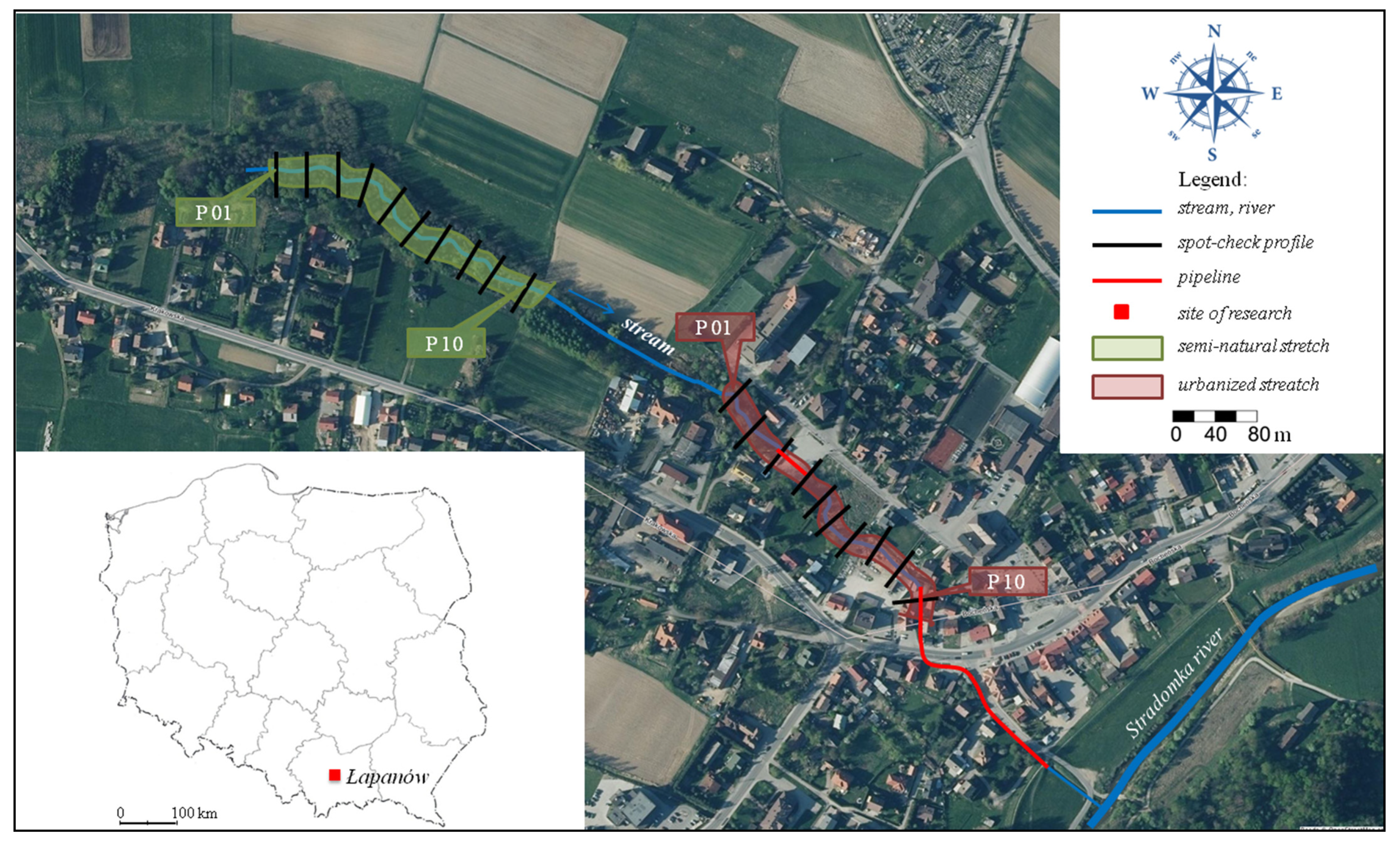
2. Materials and Methods
- (1)
- meteorological and hydrological conditions;
- (2)
- physiographic parameterisation of the stream catchment area;
- (3)
- hydromorphological characteristics of the watercourse based on HIR.
3. Results
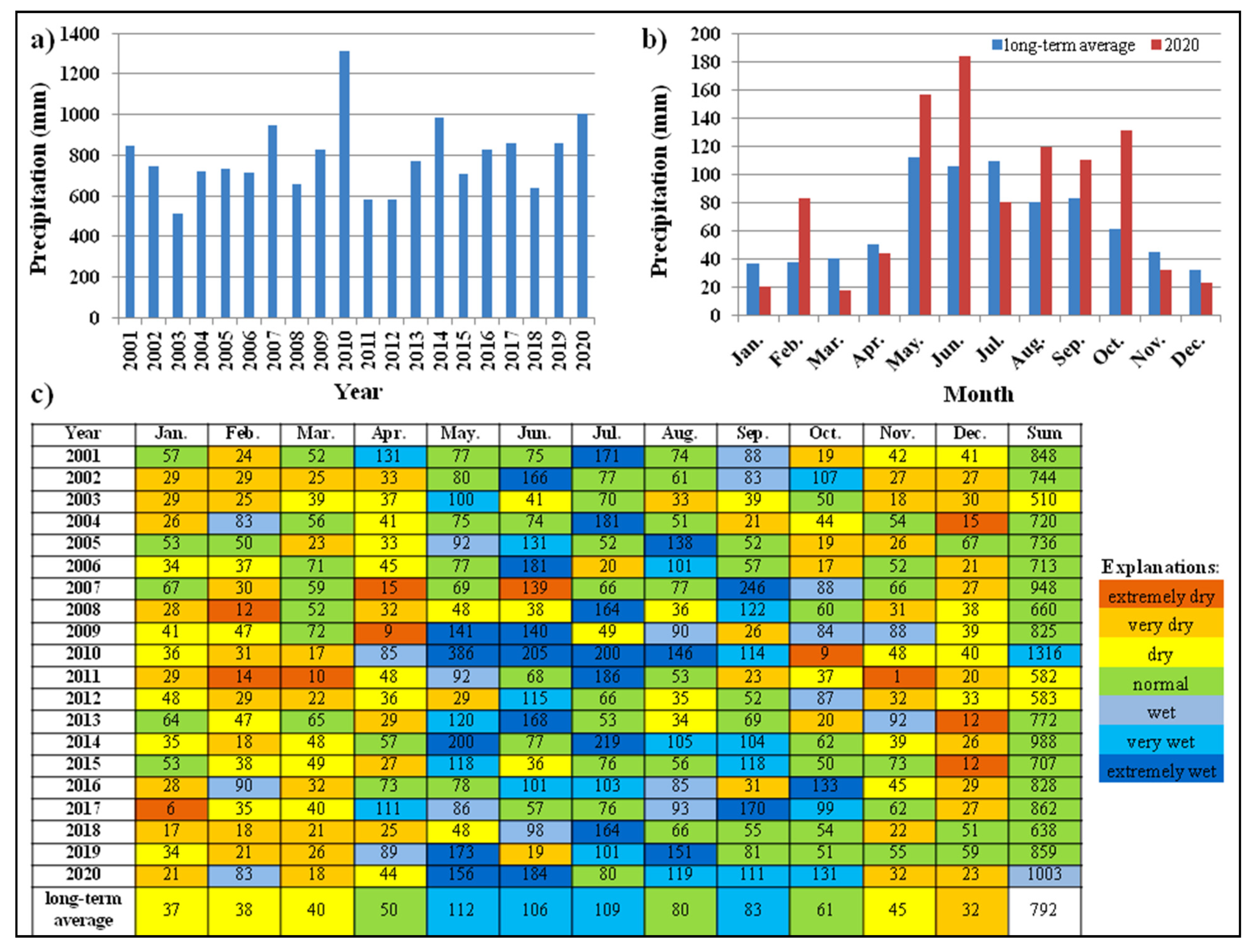
3.1. Meteorological and Hydrological Characteristics
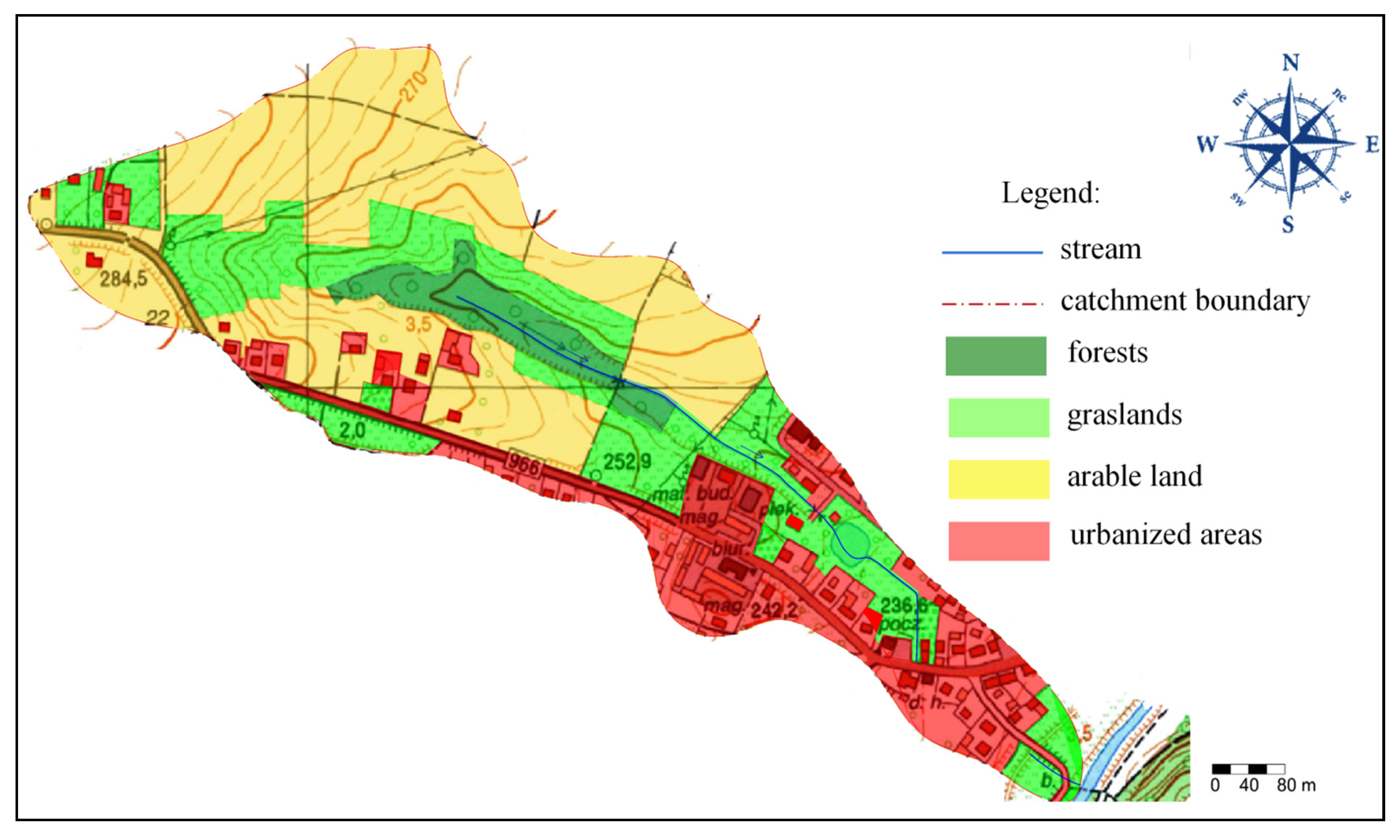
3.2. Catchment Characteristics
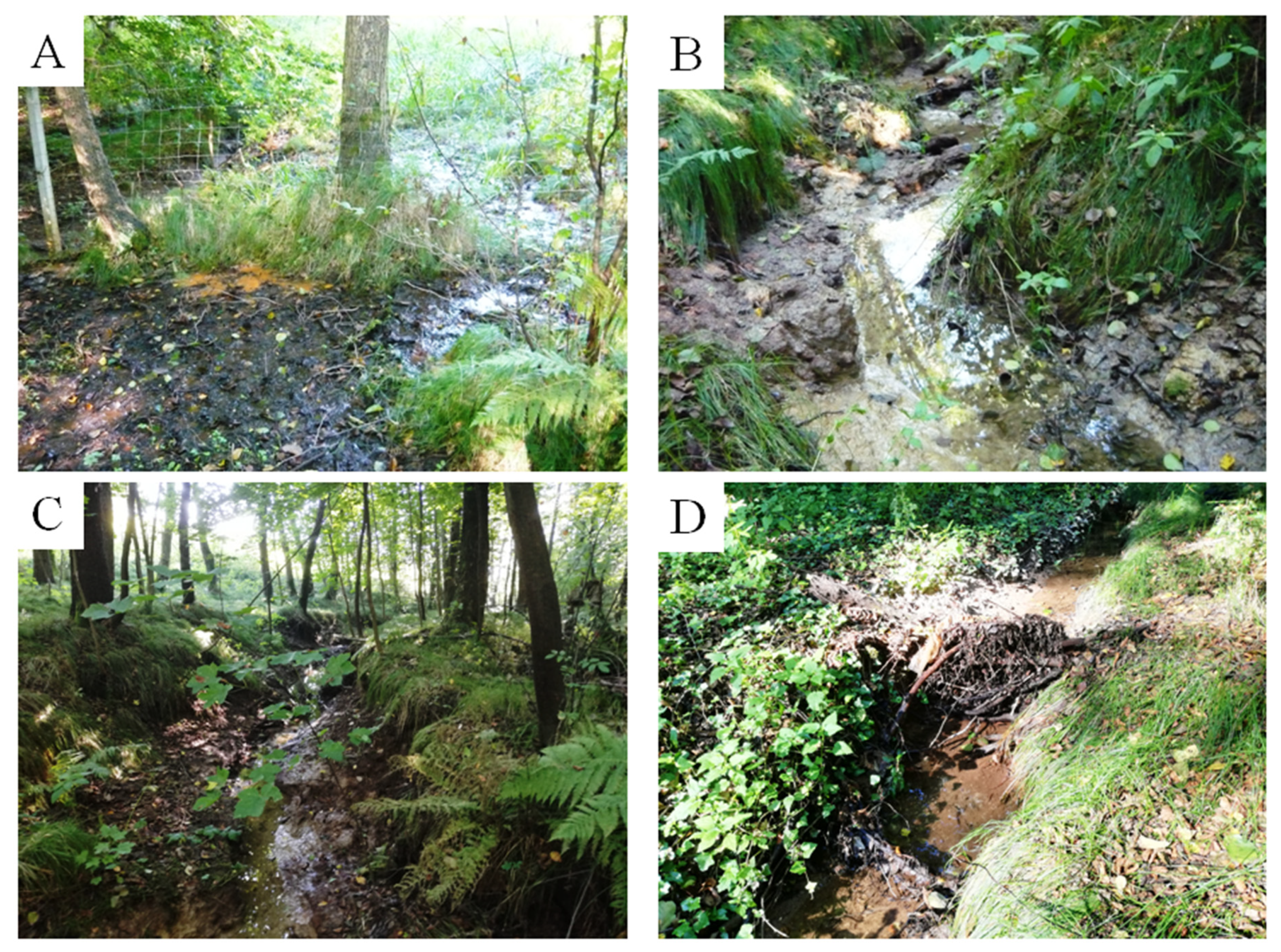
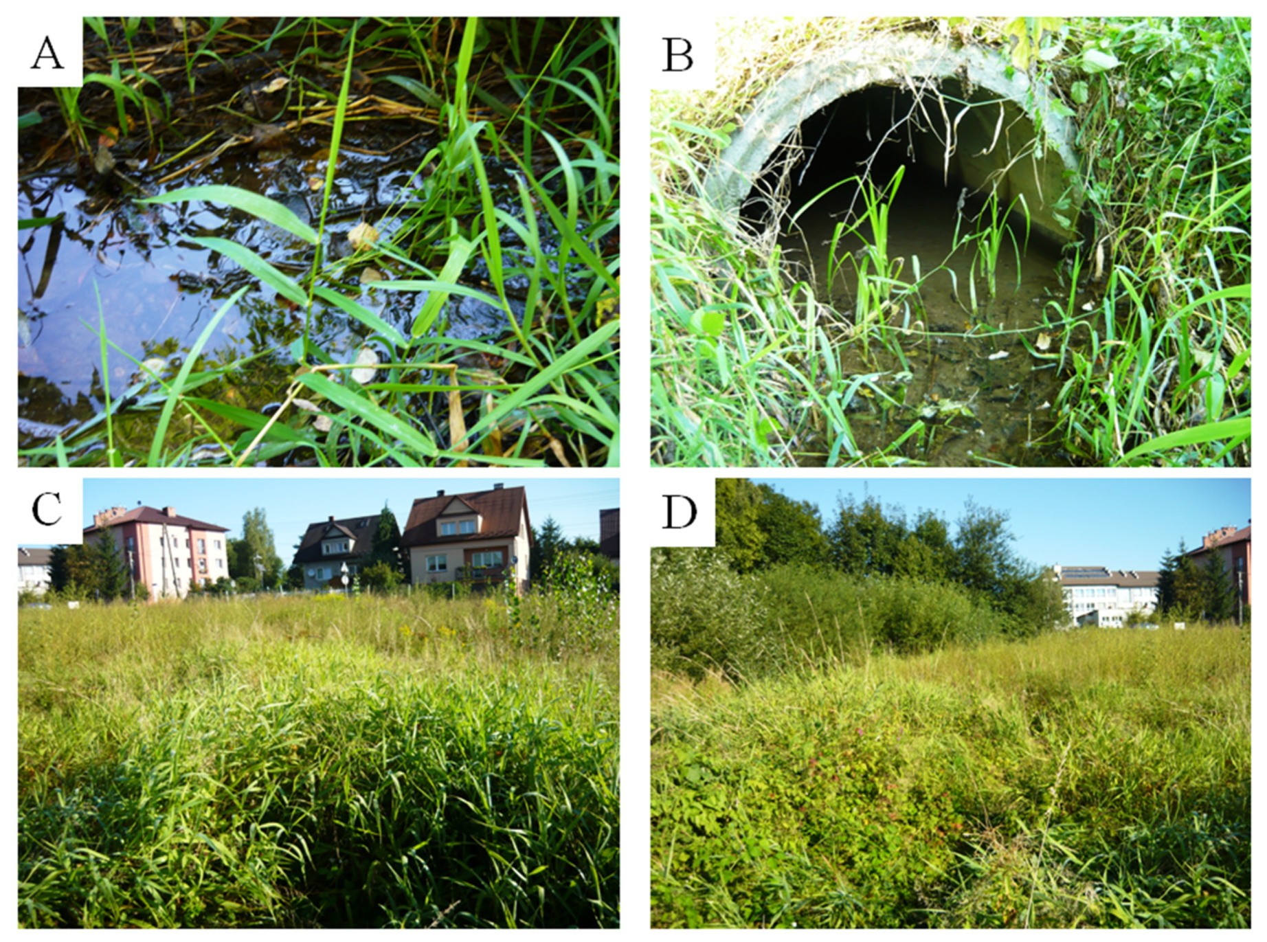
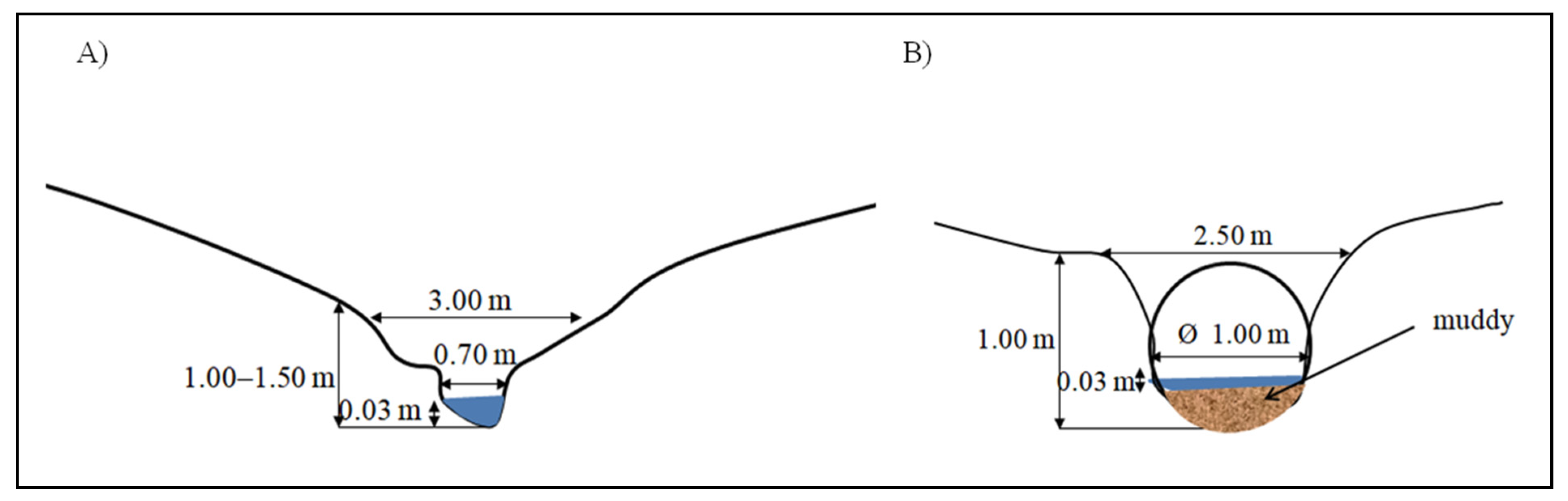
3.2.1. Characteristics of the Semi-Natural Section
3.2.2. Hydromorphological Characteristics of the Urbanised Section
4. Discussion
5. Conclusions
Author Contributions
Funding
Institutional Review Board Statement
Informed Consent Statement
Data Availability Statement
Conflicts of Interest
References
- Dawson, C.P.; Hendee, J.C. Introduction to Forests and Renewable Resources, 9th ed.; Waveland Press: Long Grove, IL, USA, 2019; Available online: https://books.google.pl/books?id=wZG4DwAAQBAJ&pg=PA430&lpg=PA430&dq=upland+stream+gradient&source=bl&ots=UMIyzqRIPy&sig=ACfU3U2VKor7jpnxwgScPDzliJYmtwLgOw&hl=pl&sa=X&ved=2ahUKEwjW74PP5L_0AhXilYsKHTexBLIQ6AF6BAg0EAM#v=onepage&q=upland%20stream%20gradient&f=false (accessed on 26 November 2021).
- Głowacki, W. Newly Emerging Geosites in the Polish Western Outer Carpathians as an Asset for Geoeducation and Geotourism. Geoheritage 2019, 11, 1247–1256. [Google Scholar] [CrossRef] [Green Version]
- Hauer, C.; Pulg, U. The non-fluvial nature of Western Norwegian rivers and the implications for channel patterns and sediment composition. Catena 2018, 171, 83–98. [Google Scholar] [CrossRef]
- Hauer, C.; Pulg, U. Buried and forgotten—The non-fluvial characteristics of postglacial rivers. River Res. Appl. 2021, 37, 123–127. [Google Scholar] [CrossRef] [Green Version]
- Kondracki, J. Regional Geography of Poland; PWN: Warszawa, Poland, 2011. (In Polish) [Google Scholar]
- Hajdukiewicz, H.; Wyżga, B.; Zawiejska, J.; Amirowicz, A.; Oglecki, P.; Radecki-Pawlik, A. Assessment of river hydromorphological quality for restoration purposes: An example of the application of RHQ method to a Polish Carpathian river. Acta Geophys. 2017, 65, 423–440. [Google Scholar] [CrossRef] [Green Version]
- Bryndal, T.; Kroczak, R. Reconstruction and characterization of the surface drainage system functioning during extreme rainfall: The analysis with use of the ALS-LIDAR data—the case study in two small flysch catchments (Outer Carpathian, Poland). Environ. Earth Sci. 2019, 78, 215. [Google Scholar] [CrossRef] [Green Version]
- Jakubínský, J.; Pelíšek, I.; Cudlín, P. Linking Hydromorphological Degradation with Environmental Status of Riparian Ecosystems: A Case Study in the Stropnice River Basin, Czech Republic. Forests 2020, 11, 460. [Google Scholar] [CrossRef] [Green Version]
- Bogdał, A.; Kowalik, T. Variability of values of physicochemical water quality indices along the length of the Iwoniczanka stream. J. Ecol. Eng. 2015, 16, 168–175. [Google Scholar] [CrossRef] [Green Version]
- Policht-Latawiec, A.; Bogdal, A.; Kanownik, W.; Kowalik, T.; Ostrowski, K. Variability of physicochemical properties of water of the transboundary Poprad river. J. Ecol. Eng. 2015, 16, 100–109. [Google Scholar] [CrossRef] [Green Version]
- Allaire, M.C.; Vogel, R.M.; Kroll, C.N. The hydromorphology of an urbanizing watershed using multivariate elasticity. Adv. Water Resour. 2015, 86, 147–154. [Google Scholar] [CrossRef]
- Vaughan, I.P.; Diamond, M.; Gurnell, A.M.; Hall, K.A.; Jenkins, A.; Milner, N.J.; Naylor, L.A.; Sear, D.A.; Woodward, G.; Ormerod, S.J. Integrating ecology with hydromorphology: A priority for river science and management. Aquat. Conserv. Mar. Freshw. Ecosyst. 2009, 19, 113–125. [Google Scholar] [CrossRef] [Green Version]
- Vogel, R.M. Hydromorphology. J. Water Resour. Plan. Manag. 2011, 137, 147–149. [Google Scholar] [CrossRef]
- European Commission. Directive 2000/60/EC of the European Parliament and of the Council of 23 October 2000 establishing a framework for community action in the field of water policy. Off. J. Eur. Community 2000, 60, 1–72. [Google Scholar]
- EN 14614; Water Quality—Guidance Standard for Assessing the Hydromorphological Features of Rivers. CEN: Brussels, Belgium, 2004; p. 21. Available online: http://www.safrass.com/partners_area/BSI%20Hydromorphology.pdf (accessed on 27 November 2021).
- EN 15843; Water Quality—Guidance Standard on Determining the Degree of Modification of River Hydromorphology. CEN: Brussels, Belgium, 2010; p. 24.
- Frissell, C.A.; Liss, W.J.; Warren, C.E.; Hurley, M.D. A hierarchical approach to classifying stream habitat features: Viewing streams in a watershed context. Environ. Manag. 1986, 10, 199–214. [Google Scholar] [CrossRef]
- Keogh, J.; Wilkes, R.; O’Boyle, S. A new index for the assessment of hydromorphology in transitional and coastal waters around Ireland. Mar. Pollut. Bull. 2020, 151, 110802. [Google Scholar] [CrossRef]
- Elosegi, A.; Sabater, S. Effects of hydromorphological impacts on river ecosystem functioning: A review and suggestions for assessing ecological impacts. Hydrobiologia 2013, 712, 129–143. [Google Scholar] [CrossRef]
- Belletti, B.; Rinaldi, M.; Buijse, A.D.; Gurnell, A.M.; Mosselman, E. A review of assessment methods for river hydromorphology. Environ. Earth Sci. 2015, 73, 2078–2100. [Google Scholar] [CrossRef]
- Brysiewicz, A.; Czerniejewski, P. Assessing Hydromorphological Characteristics of Small Watercourses Using the River Habitat Survey (RHS) Method. In Infrastructure and Environment, Krakowiak-Bal, A., Vaverkova, M., Eds.; Springer: Cham, Switzerland, 2019; pp. 144–153. [Google Scholar] [CrossRef]
- Stefanidis, K.; Latsiou, A.; Kouvarda, T.; Lampou, A.; Kalaitzakis, N.; Gritzalis, K.; Dimitriou, E. Disentangling the Main Components of Hydromorphological Modifications at Reach Scale in Rivers of Greece. Hydrology 2020, 7, 22. [Google Scholar] [CrossRef] [Green Version]
- Landerarbeitsgemeinschaft Wasser. LAWA Gewässerstrukturgütebewertung in der Bundesrepublik Deutschland, Verfahren für kleine und mittelgroße Fließgewässer; Landerarbeitsgemeinschaft Wasser: Schwerin, Germany, 2000. [Google Scholar]
- Wiatkowski, M.; Tomczyk, P. Comparative Assessment of the Hydromorphological Status of the Rivers Odra, Bystrzyca, and Ślęza Using the RHS, LAWA, QBR, and HEM Methods above and below the Hydropower Plants. Water 2018, 10, 855. [Google Scholar] [CrossRef] [Green Version]
- Brierley, G.J.; Fryirs, K.A. Geomorphology and River Management: Applications of the River Style Framework; Blackwell: Oxford, UK, 2005. [Google Scholar]
- Ollero, A.; Ballarín, D.; Díaz, E.; Mora, D.; Sánchez, M.; Acín, V.; Echeverría, M.T.; Granado, D.; Ibisate, A.; Sánchez, L.; et al. Un indice hidrogeomorfologico (IHG) para la evaluacion del estado ecologico de sistemas fluviales. Geographicalia 2007, 52, 113–141. [Google Scholar] [CrossRef] [Green Version]
- Rinaldi, M.; Belletti, B.; Van de Bund, W.; Bertoldi, W.; Gurnell, A.; Buijse, T.; Mosselman, E. Review on eco-hydromorphological methods. Deliverable 1.1, REFORM (REstoring rivers FOR effective catchment Management), Project funded by the European Commission within the 7th Framework Programme (2007–2013), Topic ENV.2011.2.1.2-1 hydromorphology and ecological objectives of WFD 2013, Grant Agreement 282656. Available online: https://www.researchgate.net/publication/282283692_Review_on_eco-hydromorphological_methods (accessed on 11 September 2021).
- Wyżga, B.; Amirowicz, A.; Radecki-Pawlik, A.; Zawiejska, J. Hydromorphological conditions, potential fish habitats and the fish community in a mountain river subjected to variable human impacts, the Czarny Dunajec, Polish Carpathians. River Res. Appl. 2009, 25, 517–536. [Google Scholar] [CrossRef]
- Gündüz, O.; Şimşek, C. Assessment of river alteration using a new hydromorphological index. Environ. Monit. Assess. 2021, 193, 1–19. [Google Scholar] [CrossRef]
- Szoszkiewicz, K.; Jusik, S.; Gebler, D.; Achtenberg, K.; Adynkiewicz-Piragas, M.; Radecki-Pawlik, A.; Okruszko, T.; Pietruczuk, K.; Przesmycki, M.; Nawrocki, P. Hydromorphological Index for Rivers: A New Method for Hydromorphological Assessment and Classification for Flowing Waters in Poland. J. Ecol. Eng. 2020, 21, 261–271. [Google Scholar] [CrossRef]
- Regulation of the Ministry of Environment dated 9 November 2011on the classification of ecological status, ecological potential and chemical status of surface water bodies (Dz.U. z 2011 r. nr 258, poz. 1549). Available online: https://www.ecolex.org/details/legislation/regulation-on-classification-of-ecological-status-ecological-potential-and-chemical-status-of-homogeneous-parts-of-surface-water-lex-faoc113849/ (accessed on 15 September 2021).
- Belda, M.; Holtanová, E.; Halenka, T.; Kalvová, J. Climate classification revisited: From Köppen to Trewartha. Clim. Res. 2014, 59, 1–13. [Google Scholar] [CrossRef] [Green Version]
- Gąsiorek, E.; Musiał, E. Comparison and classification of precipitation conditions based on standardized SPI and relative RPI precipitation indices. Water-Environ.-Rural. Areas 2011, 4, 107–119. (In Polish) [Google Scholar]
- Tomaszewska, T. Susze atmosferyczne na przestrzeni ostatniego czterdziestolecia. Mater. Konf. XXV Zjazd Agrometeorologów. Olsztyn–Mierki, 1994. Olsztyn. Wydaw. ART, s. 169–178. Available online: https://isap.sejm.gov.pl (accessed on 13 September 2021).
- Lorenc, H. Studia nad 220-letnią (1779–1998) serią temperatury powietrza w Warszawie oraz ocena jej wiekowych tendencji [Studies on 220-year air temperature for Warsaw (1779–1998) and the estimation of its multiyear tendencies]. Materiały Badawcze IMGW 2000. Warszawa. Ser. Meteorologia. Nr 31. ISSN 0239-6262, p. 104. Available online: https://books.google.com.hk/books/about/Studia_nad_220_letni%C4%85_1779_1998_seri%C4%85.html?id=wrAZHAAACAAJ&redir_esc=y (accessed on 13 September 2021).
- Lorenc, H. Termiczno-Opadowa Ocena Klimatycznych Sezonów Roku w Polsce Oraz Tendencje Czasowo-Przestrzenne. Projekt Badawczy M-9, IMGW 2000, Maszynopis. Available online: https://www.imgw.pl/sites/default/files/2020-08/imgw_wspolczesne-problemy-klimatu-polski.pdf (accessed on 12 September 2021).
- Punzet, J. Empiryczny system ocen charakterystycznych przepływów rzek i potoków w karpackiej części Dorzecza Wisły. Wiadomości IMGW 1981, 1–2, 31–39. [Google Scholar]
- Wałęga, A.; Młyński, D.; Wojkowski, J.; Radecki-Pawlik, A.; Lepeška, T. New Empirical Model Using Landscape Hydric Potential Method to Estimate Median Peak Discharges in Mountain Ungauged Catchments. Water 2020, 12, 983. [Google Scholar] [CrossRef] [Green Version]
- Młyński, D.; Wałęga, A.; Stachura, T.; Kaczor, G. A New Empirical Approach to Calculating Flood Frequency in Ungauged Catchments: A Case Study of the Upper Vistula Basin, Poland. Water 2019, 11, 601. [Google Scholar] [CrossRef] [Green Version]
- Sassolas-Serrayet, T.; Cattin, R.; Ferry, M. The shape of watersheds. Nat. Commun. 2018, 9, 3791. [Google Scholar] [CrossRef] [PubMed] [Green Version]
- Pałeczkowska, E. Slope-Fluvial System Structure in the Western Tatra Mountains (Poland): Slope-to-Channel Transition. Arct. Antarct. Alp. Res. 2017, 49, 569–583. [Google Scholar] [CrossRef] [Green Version]
- Szoszkiewicz, K.; Jusik, S.; Adynkiewicz-Piragas, M.; Gebler, D.; Achtenberg, K.; Radecki-Pawlik, A.; Okruszko, T.; Gielczewski, M.; Pietruczuk, K.; Przesmycki, M.; et al. Podręcznik Oceny Wód Płynących w Oparciu o Hydromorfologiczny Indeks Rzeczny; Biblioteka Monitoringu Środowiska: Warszawa, Poland, 2017; p. 189. [Google Scholar]
- Institute of Meteorology and Water Management–National Research Institute. Climate of Poland in 2020. Available online: https://www.imgw.pl/sites/default/files/2021-04/imgw-pib-klimat-polski-2020-opracowanie-final-eng-rozkladowki-min.pdf. (accessed on 6 January 2022).
- Rajwa-Kuligiewicz, A.; Bialik, R.J.; Rowiński, P.M. Dissolved oxygen and water temperature dynamics in lowland rivers over various timescales. J. Hydrol. Hydromech. 2015, 63, 353–363. [Google Scholar] [CrossRef] [Green Version]
- Baran-Zgłobicka, B.; Godziszewska, D.; Zgłobicki, W. The Flash Floods Risk in the Local Spatial Planning (Case Study: Lublin Upland, E Poland). Resources 2021, 10, 14. [Google Scholar] [CrossRef]
- Zeleňáková, M.; Kubiak-Wójcicka, K.; Negm, A.M. (Eds.) Management of Water Resources in Poland; Springer Water: Cham, Switzerland, 2021; p. 429. [Google Scholar]
- Ionita, M.; Dima, M.; Nagavciuc, V.; Scholz, P.; Lohmann, G. Past megadroughts in central Europe were longer, more severe and less warm than modern droughts. Commun. Earth Environ. 2021, 2, 61. [Google Scholar] [CrossRef]
- Peszek, Ł.; Zgrundo, A.; Noga, T.; Kochman-Kędziora, N.; Poradowska, A.; Rybak, M.; Puchalski, C.; Lee, J. The influence of drought on diatom assemblages in a temperate climate zone: A case study from the Carpathian Mountains, Poland. Ecol. Indic. 2021, 125, 107579. [Google Scholar] [CrossRef]
- Kundzewicz, Z.W.; Piniewski, M.; Mezghani, A.; Okruszko, T.; Pińskwar, I.; Kardel, I.; Hov, Ø.; Szcześniak, M.; Szwed, M.; Benestad, R.E.; et al. Assessment of climate change and associated impact on selected sectors in Poland. Acta Geophys. 2018, 66, 1509–1523. [Google Scholar] [CrossRef] [Green Version]
- Ziernicka-Wojtaszek, A.; Kopcińska, J. Variation in Atmospheric Precipitation in Poland in the Years 2001–2018. Atmosphere 2020, 11, 794. [Google Scholar] [CrossRef]
- Sojka, M.; Kozłowski, M.; Kęsicka, B.; Wróżyński, R.; Stasik, R.; Napierała, M.; Jaskuła, J.; Liberacki, D. The Effect of Climate Change on Controlled Drainage Effectiveness in the Context of Groundwater Dynamics, Surface, and Drainage Outflows. Central-Western Poland Case Study. Agronomy 2020, 10, 625. [Google Scholar] [CrossRef]
- Atwood, A.R.; Battisti, D.S.; Wu, E.; Frierson, D.M.W.; Sachs, J.P. Data-Model Comparisons of Tropical Hydroclimate Changes Over the Common Era. Paleoceanogr. Paleoclimatology 2021, 36, 7. [Google Scholar] [CrossRef]
- Pokrývková, J.; Jurík, Ľ.; Lackóová, L.; Halászová, K.; Hanzlík, R.; Banihabib, M.E. The Urban Environment Impact of Climate Change Study and Proposal of the City Micro-Environment Improvement. Sustainability 2021, 13, 4096. [Google Scholar] [CrossRef]
- Bucała, A.; Wiejaczka, Ł. Evaluation of the hydromorphological state of mountain streams under the influence of contemporary human activity (Polish Carpathians). Environ. Earth Sci. 2015, 73, 3451–3463. [Google Scholar] [CrossRef]
- Kijowska-Strugała, M.; Wiejaczka, Ł.; Cebulski, J.; Płaczkowska, E.; Rączkowska, Z.; Prokop, P.; Zou, Q.; Guo, Y.; Hu, J. Assessment of the naturalness and anthropogenic transformation of the habitats of small mountain streams in different climate zones. Environ. Earth Sci. 2021, 80, 267. [Google Scholar] [CrossRef]
- Casado, M.R.; Gonzalez, R.B.; Kriechbaumer, T.; Veal, A. Automated Identification of River Hydromorphological Features Using UAV High Resolution Aerial Imagery. Sensors 2015, 15, 27969–27989. [Google Scholar] [CrossRef] [Green Version]
- Woodget, A.S.; Austrums, R.; Maddock, I.P.; Habit, E. Drones and digital photogrammetry: From classifications to continuums for monitoring river habitat and hydromorphology. WIREs Water 2017, 4, e1222. [Google Scholar] [CrossRef] [Green Version]
- Kelly-Quinn, M.; Bruen, M.; Carlsson, J.; Gurnell, A.; Jarvie, H.; Piggott, J. Managing the small stream network for improved water quality, biodiversity and ecosystem services protection (SSNet). Res. Ideas Outcomes 2019, 5, e33400. [Google Scholar] [CrossRef]
- Bryndal, T.; Kroczak, R.; Kijowska-Strugała, M.; Bochenek, W. How human interference changes the drainage network operating during heavy rainfalls in a medium-high relief flysch mountain catchment? The case study of the Bystrzanka catchment (Outer Carpathians, Poland). Catena 2020, 194, 104662. [Google Scholar] [CrossRef]
- Bedla, D.; Halecki, W.; Król, K. Hydromorphological method and GIS tools with a web application to assess a semi-natural urbanised river. J. Environ. Eng. Landsc. Manag. 2021, 29, 21–32. [Google Scholar] [CrossRef]
- Pietruczuk, K.; Dajewski, K.; Garbarczyk, A.; Szoszkiewicz, K. Hydromorphological variability of a large lowland river based on the Hydromorphological Index for Rivers (HIR) basing on the Warta River. Ecol. Eng. 2020, 21, 15–25. [Google Scholar] [CrossRef]
- Gebler, D.; Szoszkiewicz, K.; Bielak, S.R. Diversity of hydromorphological conditions of rivers in the lowland and mountain catchment scale. Sci. Nat. Technol. 2013, 7, 1–12. [Google Scholar]
- Halabowski, D.; Lewin, I. Impact of anthropogenic transformations on the vegetation of selected abiotic types of rivers in two ecoregions (Southern Poland). Knowl. Manag. Aquat. Ecosyst. 2020, 421, 1–15. [Google Scholar] [CrossRef]
- Kiraga, M.J. The Diversification of River Habitat Survey Output During Four Seasons: Case Studies of Three Lowland Rivers in Poland. J. Ecol. Eng. 2020, 21, 116–126. [Google Scholar] [CrossRef]
- González del Tánago, M.; Martínez-Fernández, V.; Aguiar, F.C.; Bertoldi, W.; Dufour, S.; García de Jalón, D.; Garófano-Gómez, V.; Mandzukovskih, D.; Rodríguez-González, P.M. Improving river hydromorphological assessment through better integration of riparian vegetation: Scientific evidence and guidelines. J. Environ. Manag. 2021, 292, 112730. [Google Scholar] [CrossRef]
- Kałuża, T.; Sojka, M.; Wróżyński, R.; Jaskuła, J.; Zaborowski, S.; Hämmerling, M. Modeling of River Channel Shading as a Factor for Changes in Hydromorphological Conditions of Small Lowland Rivers. Water 2020, 12, 527. [Google Scholar] [CrossRef] [Green Version]
- Qazi, N. Hydrological functioning of forested catchments, Central Himalayan Region, India. For. Ecosyst. 2020, 7, 63. [Google Scholar] [CrossRef]
- Aduah, M.S.; Jewitt, G.P.W.; Toucher, M.L.W. Assessing Impacts of Land Use Changes on the Hydrology of a Lowland Rainforest Catchment in Ghana, West Africa. Water 2018, 10, 9. [Google Scholar] [CrossRef] [Green Version]
- Szatten, D.; Habel, M. Effects of Land Cover Changes on Sediment and Nutrient Balance in the Catchment with Cascade-Dammed Waters. Remote Sens. 2020, 12, 3414. [Google Scholar] [CrossRef]
- Borek, Ł. Assessment and classification of hydromorphological state of the Breń River. J. Water Land Dev. 2016, 30, 21–27. [Google Scholar] [CrossRef]


| Month, Period, Year | Criteria |
|---|---|
| extremely cold | T > Tav + 2.5δ |
| anomalously cold | Tav + 2.0δ < T ≤ Tav + 2.5δ |
| very cold | Tav + 1.5δ < T ≤ Tav + 2δ |
| cold | Tav + δ < T ≤ Tav + 1.5δ |
| slightly cold | Tav + 0.5δ < T ≤ Tav + δ |
| normal | Tav – 0.5δ < T ≤ Tav + 0.5δ |
| slightly warm | Tav – δ < T ≤ Tav – 0.5δ |
| warm | Tav – 0.5δ < T ≤ Tav – δ |
| very warm | Tav – δ < T ≤ Tav – 1.5δ |
| anomalously warm | Tav – 1.5δ < T ≤ Tav – 2δ |
| extremely warm | T ≤ Tav – 2.5δ |
| Item | Parameter |
|---|---|
| 1 | Topographic catchment area A [km2]—determined based on the planimetry of the area, which is closed by the boundary determining the topographic watershed |
| 2 | Maximum catchment length Lmax. [km]—main river valley length from the mouth to the point on the watershed in the extension of the spring |
| 3 | Catchment perimeter P [km]—length of the catchment’s topographic watershed |
| 4 | Catchment mean width Bz [km]—ratio of the catchment topographic area (A) to the catchment length (Lmax.): |
| 5 | Form coefficient Cf [–]*—ratio of the catchment area (A); ratio of the catchment area squared (Lmax.2): |
| 6 | Elongation coefficient CW [–]—ratio of the diameter of the circle of surface area equal to the catchment area, to the catchment length (L): |
| 7 | Circularity coefficient CK [–]—ratio of the catchment area (A), to the surface area of the circle of the same perimeter as the catchment perimeter (P): |
| 8 | Gravelius catchment compactness coefficient GC [–]—ratio of the catchment perimeter (Oz), to the perimeter of the circle of the same surface area as the catchment area (A): |
| 9 | Minimum Hmin and Hmax [m a.s.l.]—taken from the topographic map as the lowest and the highest value on the watershed |
| 10 | Altitude H [m a.s.l.]—taken from the topographic map as the lowest altitude (Hmin.) and the highest altitude (Hmax.) of the spring (Hs.) and mouth (Hm,) on the watershed |
| 11 | Channel mean altitude Hmean [m a.s.l.]—arithmetic mean of the maximum altitude (Hmax) and the minimum altitude (Hmin) in the catchment area: and from the Reitz formula: |
| 12 | Catchment area denivelation (∆H)—difference between the maximum (Hmax) and minimum (Hmin) altitude in the catchment area: ∆H = Hmax − Hmin [m] |
| 13 | Stream gradient/slope [%]—ratio of the altitude difference between the watercourse spring (Hs m a.s.l.) and mouth (Hm m a.s.l to the watercourse length in this section (Ls in m): |
| 14 | Stream length Ls (km)—distance from the spring to the mouth |
| 15 | Land use types in catchment (%)—percentages of the various forms of use in the catchment area as arable land, forests etc. |
| Parameter | Value | |
|---|---|---|
| Catchment Geometry | ||
| Topographic catchment area (A): | 0.31 km2 | |
| Maximum catchment length (Lmax.): | 1.37 km | |
| Catchment perimeter (P): | 3.10 km | |
| Mean catchment width (Bz): | 0.23 km | |
| Shape coefficient: | form (Cf): | 0.17 |
| elongation (Cw): | 0.46 | |
| circularity (Ck): | 0.41 | |
| Gravelius compactness (GC): | 1.57 | |
| Catchment Morphometry | ||
| Altitude: | minimum/mouth (Hmin.): | 229.10 m a.s.l. |
| maximum (Hmax.): | 288.30 m a.s.l. | |
| spring (Hźr.): | 253.00 m a.s.l. | |
| mean (Hśr.): | 258.70 m a.s.l. | |
| mean (Hśr.) acc. to Reitz: | 257.44 m a.s.l. | |
| Denivelation (∆H): | 59.20 m | |
| Stream gradient/slope (Jc): | 2.4% (23.9‰) | |
| Catchment Hydrography | ||
| Stream length (Lc): | ~1.00 km | |
| Type of Land Use | ||
| Forests | 6% | |
| Arable land | 41% | |
| Grassland | 28% | |
| Built-up areas | 25% | |
| Sum | 100% | |
| Parameters Collected during the On-Site Evaluation | Section | |
|---|---|---|
| Semi-Natural | Urbanised | |
| HDS | ||
| 1. The stream channel zone—riverbed | ||
| 1.1. Variation of the river line | 3.0 (5.3%) | 0.0 (0.0%) |
| 1.2. Variation of the riverbed slope | 3.0 (5.3%) | 1.0 (3.5%) |
| 1.3. Heterogeneity of water flow | 5.0 (9.0%) | 3.0 (11.0%) |
| 1.4. Bed material heterogeneity | 4.0 (7.3%) | 4.0 (15.0%) |
| 1.5. Natural morphological elements of the bed-bottom | 1.0 (1.8%) | 0.0 (0.0%) |
| 1.6. Natural morphological elements of the slopes | 10.0 (17.8%) | 4.0 (15.0%) |
| 1.7. Vegetation diversity in the bed | 5.0 (9.0%) | 4.0 (15.0%) |
| 2. The stream channel zone—bank face | ||
| 2.1. Vegetation structure on the slopes | 0.0 (0.0%) | 0.0 (0.0%) |
| 2.2. Diversity of elements accompanying the trees | 8.0 (14.3%) | 1.0 (3.5%) |
| 3. The stream valley adjacent to the bank-top zone | ||
| 3.1. Structure of bank-top vegetation | 5.0 (9.0%) | 4.0 (15.0%) |
| 3.2. Not-managed bank-top zone | 4.0 (7.3%) | 3.0 (11.0%) |
| 4. The stream valley zone | ||
| 4.1. Natural land use of the valley | 8.0 (14.3%) | 3.0 (11.0%) |
| 4.2. Connection between the stream and the valley | 0.0 (0.0%) | 0.0 (0.0%) |
| ƩHDS | 56.0 (100%) | 27.0 (100%) |
| HMS | ||
| 1. Transformed transverse section of the stream channel | 0.0 (0.0%) | 2.0 (12.9%) |
| 2. Hydroengineering structures | 0.0 (0.0%) | 0.5 (3.2%) |
| 3. Transformations observed in spot-checks | 0.0 (0.0%) | 6.0 (38.7%) |
| 4. Disturbance of the connectivity with the river valley | 0.0 (0.0%) | 4.0 (25.8%) |
| 5. Other types of human degradation | 0.0 (0.0%) | 3.0 (19.4%) |
| ƩHMS | 0.0 (0.0%) | 15.5 (100%) |
| Item | Measuring Section | Study Section | Watercourse/Stream (Whole) | ||||
|---|---|---|---|---|---|---|---|
| HIR | Hydromorphological Condition | Class | HIRmean | Hydromorphological Condition | Class | ||
| 1 | semi-natural | 0.78 | good | II | 0.61 | moderate | III |
| 2 | urbanised | 0.54 | poor | IV | |||
Publisher’s Note: MDPI stays neutral with regard to jurisdictional claims in published maps and institutional affiliations. |
© 2022 by the authors. Licensee MDPI, Basel, Switzerland. This article is an open access article distributed under the terms and conditions of the Creative Commons Attribution (CC BY) license (https://creativecommons.org/licenses/by/4.0/).
Share and Cite
Borek, Ł.; Kowalik, T. Hydromorphological Inventory and Evaluation of the Upland Stream: Case Study of a Small Ungauged Catchment in Western Carpathians, Poland. Land 2022, 11, 141. https://doi.org/10.3390/land11010141
Borek Ł, Kowalik T. Hydromorphological Inventory and Evaluation of the Upland Stream: Case Study of a Small Ungauged Catchment in Western Carpathians, Poland. Land. 2022; 11(1):141. https://doi.org/10.3390/land11010141
Chicago/Turabian StyleBorek, Łukasz, and Tomasz Kowalik. 2022. "Hydromorphological Inventory and Evaluation of the Upland Stream: Case Study of a Small Ungauged Catchment in Western Carpathians, Poland" Land 11, no. 1: 141. https://doi.org/10.3390/land11010141
APA StyleBorek, Ł., & Kowalik, T. (2022). Hydromorphological Inventory and Evaluation of the Upland Stream: Case Study of a Small Ungauged Catchment in Western Carpathians, Poland. Land, 11(1), 141. https://doi.org/10.3390/land11010141