


Planform Changes in the Lower Mahaweli River, Sri Lanka Using Landsat Satellite Data

 , , ,
, , ,  and
and 
Abstract
:1. Introduction
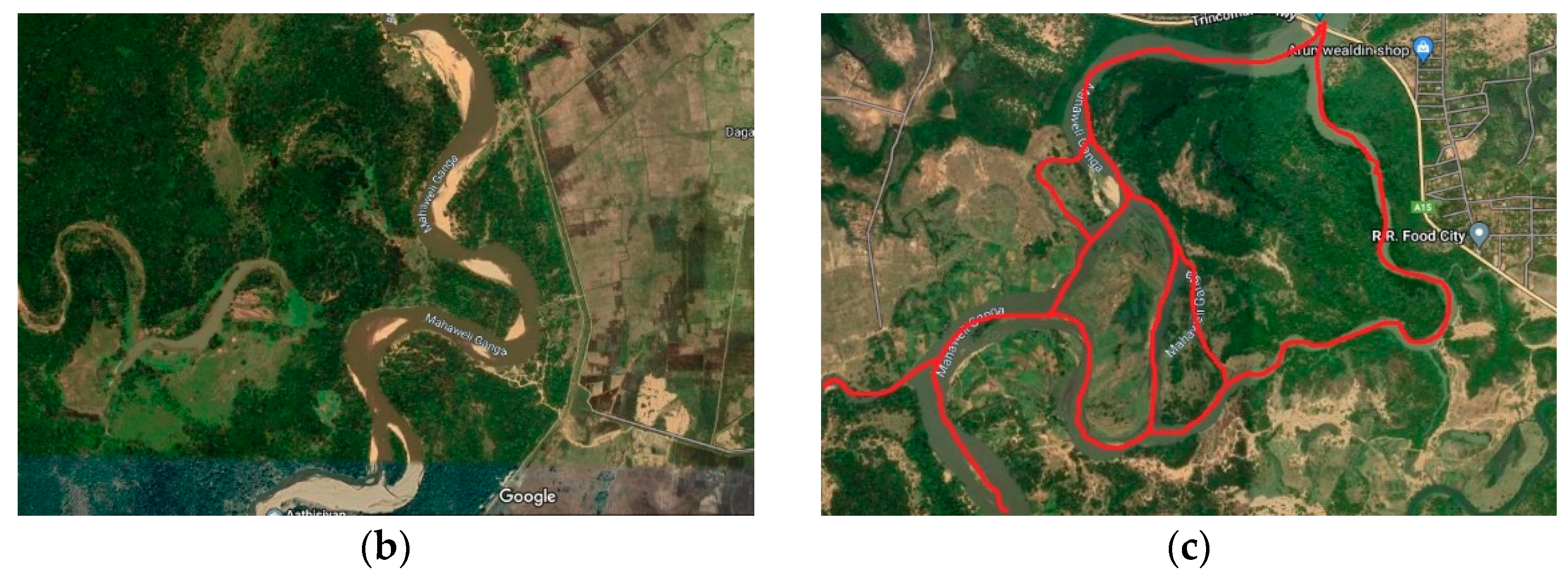
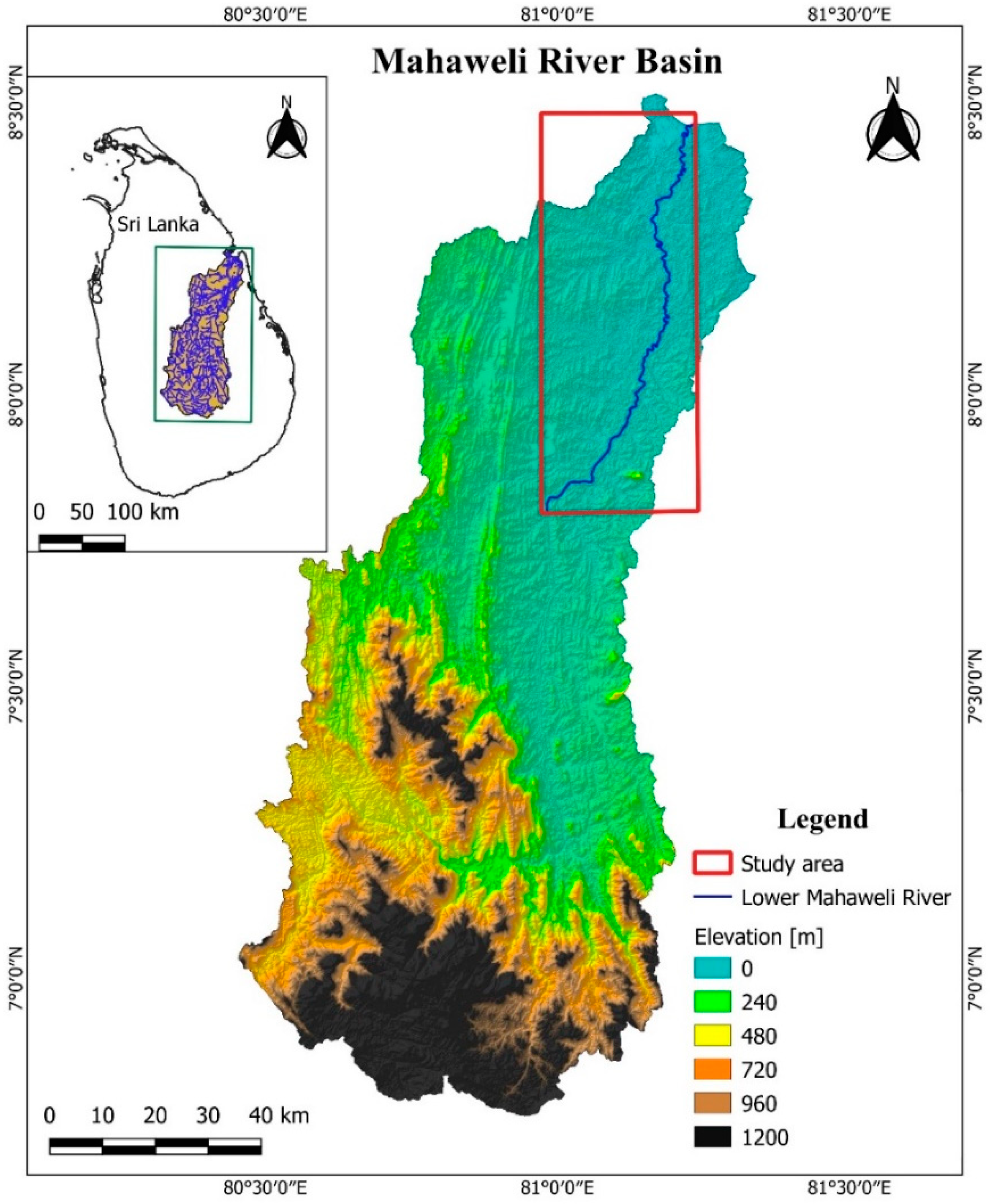
2. Study Area and Problem Statement
3. Data and Methods
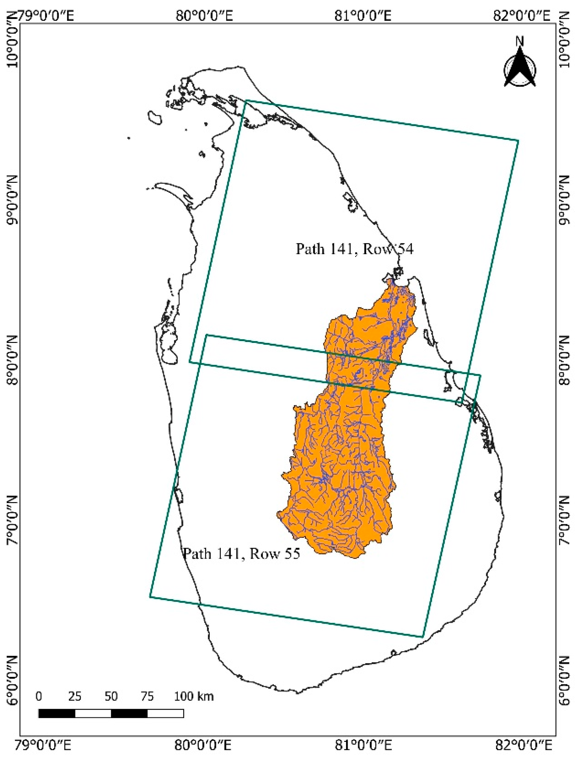
3.1. Use of Landsat Imagery
3.2. Generating the River Masks
3.3. Cleaning the River Masks
3.4. Delineating River Centerlines
3.5. Estimation of River Planform Geometry
3.6. Calculating the Centerline Migration
3.7. Overall Methodology
4. Results and Discussion
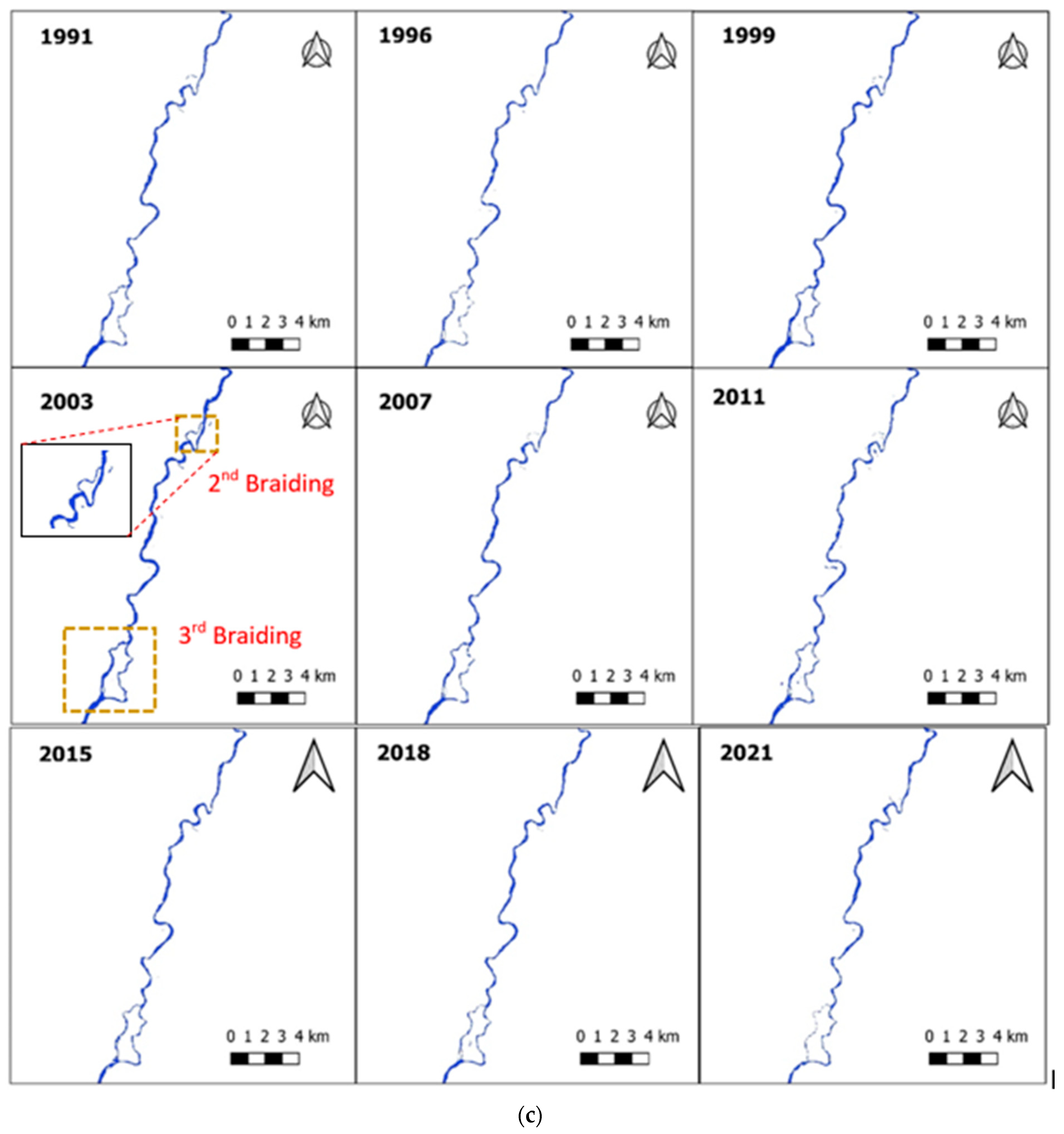
4.1. River Planform
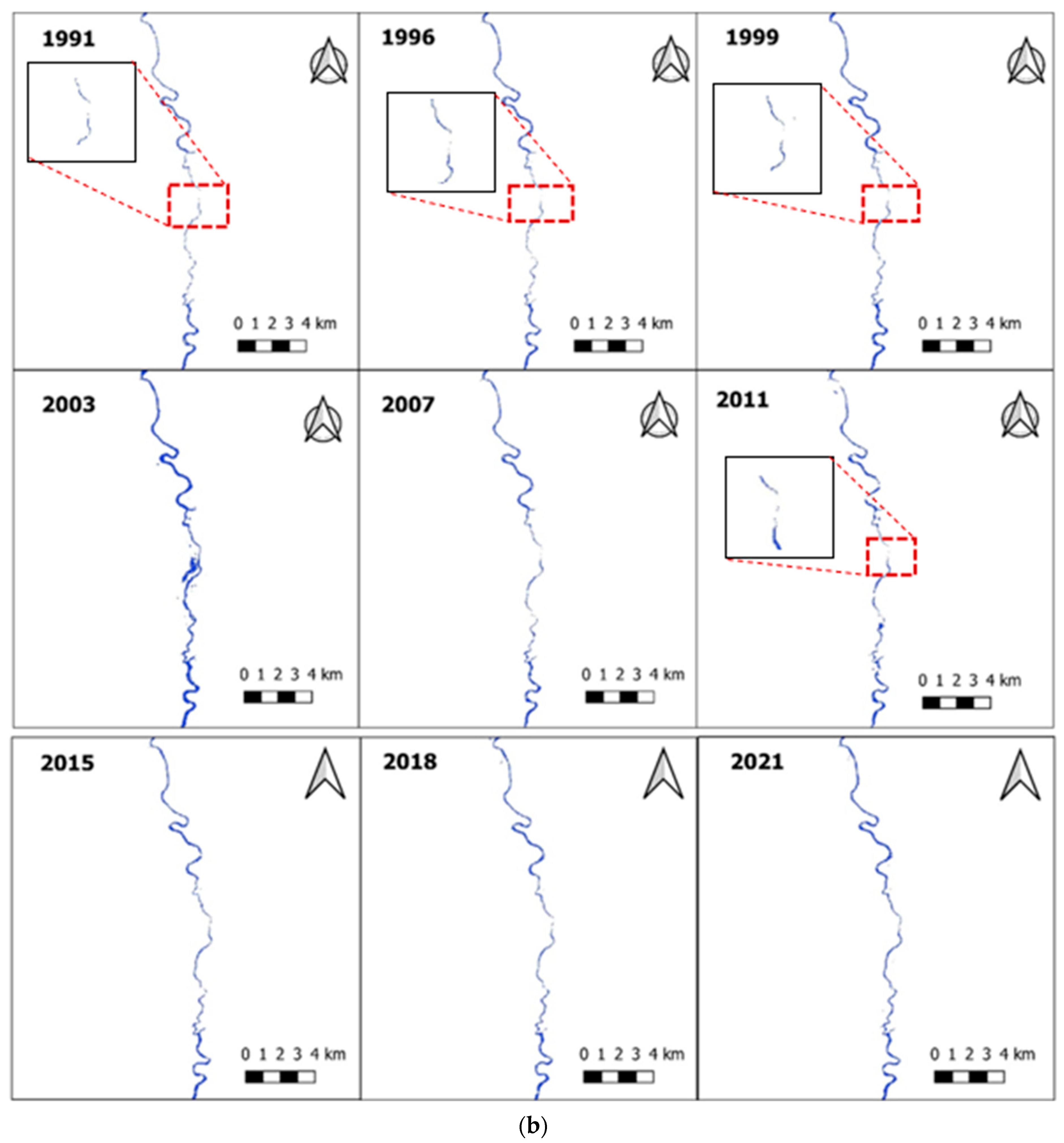
4.2. Spatiotemporal Variation of River Centreline
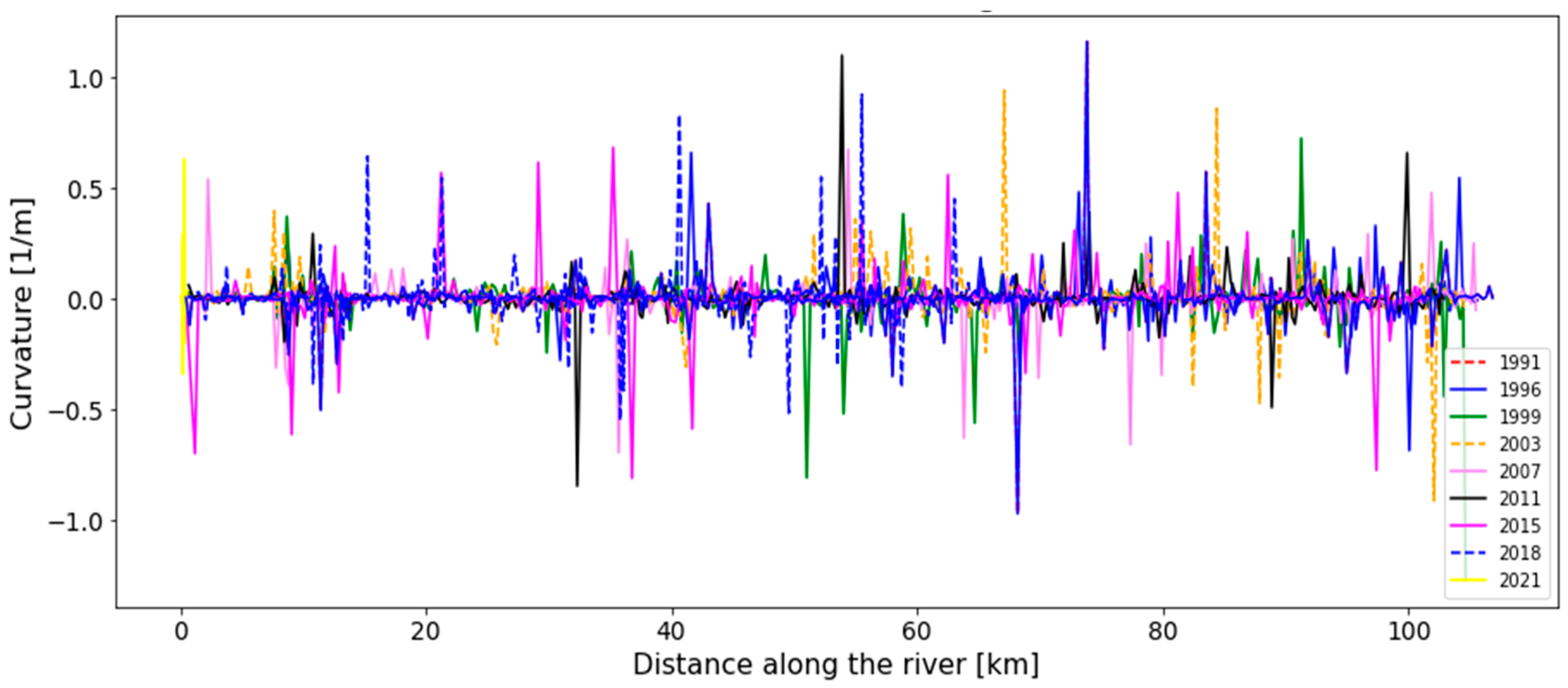
4.3. Variation of River Curvature
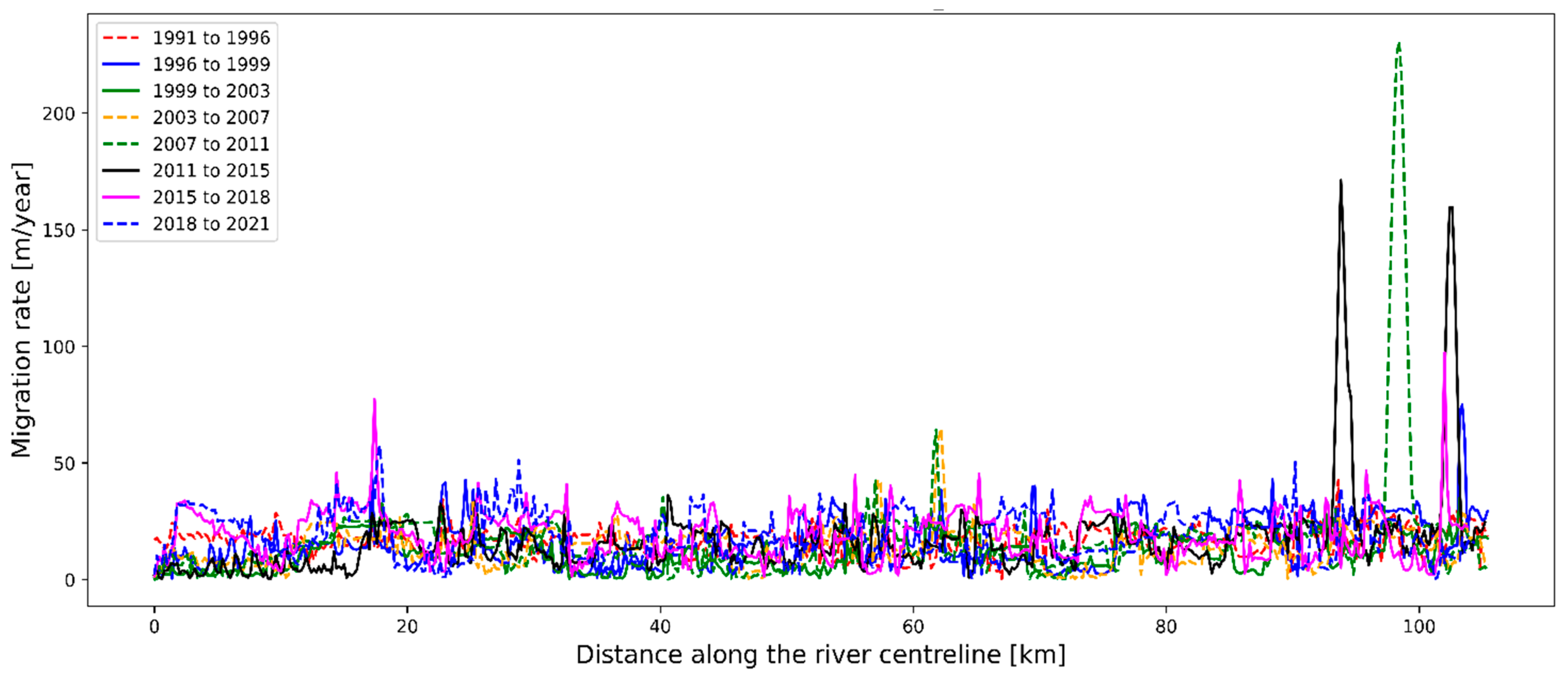
4.4. Variation of River Centreline Migration
5. Summary and Conclusions
Author Contributions
Funding
Data Availability Statement
Conflicts of Interest
References
- Constantine, J.A.; Dunne, T.; Ahmed, J.; Legleiter, C.; Lazarus, E. Sediment supply as a driver of river meandering and floodplain evolution in the Amazon Basin. Nat. Geosci. 2014, 7, 899–903. [Google Scholar] [CrossRef] [Green Version]
- Zanoni, L.; Gurnell, A.; Drake, N.; Surian, N. Island dynamics in a braided river from analysis of historical maps and air photographs. River Res. Appl. 2008, 24, 1141–1159. [Google Scholar] [CrossRef]
- James, J.S.H.; Rogala, T.; Fitzpatrick, F.A. Recent Planform Changes in the Upper Mississippi River. U.S. Geological Survey. Upper Midwest Environmental Sciences Center. 2020. Available online: https://www.usgs.gov/publications/recent-planform-changes-upper-mississippi-river (accessed on 1 September 2022).
- Rădoane, M.; Perşoiu, I.; Cristea, I.; Chiriloaei, F. River channel planform changes based on succesive cartographic data. A methodological approach. J. Geomorphol. 2013, 15, 69–88. [Google Scholar]
- Monegaglia, F.; Zolezzi, G.; Güneralp, I.; Henshaw, A.J.; Tubino, M. Automated extraction of meandering river morphodynamics from multitemporal remotely sensed data. Environ. Model. Softw. 2018, 105, 171–186. [Google Scholar] [CrossRef]
- Deb, M.; Das, D.; Uddin, M. Evaluation of Meandering Characteristics Using RS & GIS of Manu River. J. Water Resour. Prot. 2012, 4, 163–171. [Google Scholar] [CrossRef]
- Dey, A.; Bhattacharya, R.K. Monitoring of River Center Line and Width—A Study on River Brahmaputra. J. Indian Soc. Remote Sens. 2013, 42, 475–482. [Google Scholar] [CrossRef]
- Monegaglia, F. Meandering Rivers Morphodynamics—Integrating Nonlinear Modeling and Remote Sensing. 2017, p. 250. Available online: http://qmro.qmul.ac.uk/xmlui/handle/123456789/33927 (accessed on 1 September 2022).
- Ashworth, P.J.; Best, J.L.; Roden, J.E.; Bristow, C.S.; Klaassen, G.J. Morphological evolution and dynamics of a large, sand braid-bar, Jamuna River, Bangladesh. Sedimentology 2000, 47, 533–555. [Google Scholar] [CrossRef]
- Gilvear, D.; Winterbottom, S.; Sichingabula, H. Character of channel planform change and meander development: Luangwa River, Zambia. Earth Surf. Process. Landf. 2000, 25, 421–436. [Google Scholar] [CrossRef]
- Mosselman, E. Morphological modelling of rivers with erodible banks. Hydrol. Process. 1998, 12, 1357–1370. [Google Scholar] [CrossRef]
- Mosselman, E. A review of mathematical models of river planform changes. Earth Surf. Process. Landf. 1995, 20, 661–670. [Google Scholar] [CrossRef]
- Winterbottom, S.; Gilvear, D. A GIS-based approach to mapping probabilities of river bank erosion: Regulated River Tummel, Scotland. Regul. Rivers Res. Manag. 2000, 16, 127–140. [Google Scholar] [CrossRef]
- Boothroyd, R.; Williams, R.; Barrett, B.; Hoey, T.; Tolentino, P.; Perez, J.; Guardian, E.; David, C.; Yang, X. Detecting and Quantifying Morphological Change in Tropical Rivers Using Google Earth Engine and Image Analysis Techniques. In River Flow 2020; CRC Press: Boca Raton, FL, USA, 2020; pp. 1013–1021. [Google Scholar] [CrossRef]
- Basnayaka, V.; Samarasinghe, J.T.; Gunathilake, M.B.; Muttil, N.; Hettiarachchi, D.C.; Abeynayaka, A.; Rathnayake, U. Analysis of Meandering River Morphodynamics Using Satellite Remote Sensing Data—An Application in the Lower Deduru Oya (River), Sri Lanka. Land 2022, 11, 1091. [Google Scholar] [CrossRef]
- Hemati, M.; Hasanlou, M.; Mahdianpari, M.; Mohammadimanesh, F. A Systematic Review of Landsat Data for Change Detection Applications: 50 Years of Monitoring the Earth. Remote Sens. 2021, 13, 2869. [Google Scholar] [CrossRef]
- Wray, R.A. Palaeochannels of the Namoi River Floodplain, New South Wales, Australia: The use of multispectral Landsat imagery to highlight a Late Quaternary change in fluvial regime. Aust. Geogr. 2009, 40, 29–49. [Google Scholar] [CrossRef]
- Schwenk, J.; Khandelwal, A.; Fratkin, M.; Kumar, V.; Foufoula-Georgiou, E. High spatiotemporal resolution of river planform dynamics from Landsat: The RivMAP toolbox and results from the Ucayali River. Earth Space Sci. 2017, 4, 46–75. [Google Scholar] [CrossRef]
- Nagel, G.W.; Novo, E.M.L.D.M.; Martins, V.S.; Campos-Silva, J.V.; Barbosa, C.C.F.; Bonnet, M.P. Impacts of meander migration on the Amazon riverine communities using Landsat time series and cloud computing. Sci. Total Environ. 2022, 806, 150449. [Google Scholar] [CrossRef]
- Shelton, S.; Lin, Z. Streamflow Variability in Mahaweli River Basin of Sri Lanka during 1990–2014 and Its Possible Mechanisms. Water 2019, 11, 2485. [Google Scholar] [CrossRef] [Green Version]
- Rubel, F.; Kottek, M. Observed and projected climate shifts 1901-2100 depicted by world maps of the Köppen-Geiger climate classification. Meteorol. Z. 2010, 19, 135–141. [Google Scholar] [CrossRef] [Green Version]
- Withanachchi, S.S.; Köpke, S.; Withanachchi, C.R.; Pathiranage, R.; Ploeger, A. Water Resource Management in Dry Zonal Paddy Cultivation in Mahaweli River Basin, Sri Lanka: An Analysis of Spatial and Temporal Climate Change Impacts and Traditional Knowledge. Climate 2014, 2, 329–354. [Google Scholar] [CrossRef]
- Ranasinghe, P.; Fernando, G.; Dissanayake, C.; Rupasinghe, M. Stream sediment geochemistry of the Upper Mahaweli River Basin of Sri Lanka—Geological and environmental significance. J. Geochem. Explor. 2008, 99, 1–28. [Google Scholar] [CrossRef]
- Dissanayake, C.B.; Weerasooriya, S.V.R. The environmental chemistry of Mahaweli river, Sri Lanka. Int. J. Environ. Stud. 1986, 28, 207–223. [Google Scholar] [CrossRef]
- Hansen, M.C.; Loveland, T.R. A review of large area monitoring of land cover change using Landsat data. Remote Sens. Environ. 2012, 122, 66–74. [Google Scholar] [CrossRef]
- Isikdogan, F.; Bovik, A.; Passalacqua, P. RivaMap: An automated river analysis and mapping engine. Remote Sens. Environ. 2017, 202, 88–97. [Google Scholar] [CrossRef]
- Feyisa, G.L.; Meilby, H.; Fensholt, R.; Proud, S.R. Automated Water Extraction Index: A new technique for surface water mapping using Landsat imagery. Remote Sens. Environ. 2014, 140, 23–35. [Google Scholar] [CrossRef]
- Crist, E.P. A TM Tasseled Cap equivalent transformation for reflectance factor data. Remote Sens. Environ. 1985, 17, 301–306. [Google Scholar] [CrossRef]
- McFeeters, S.K. The use of the Normalized Difference Water Index (NDWI) in the delineation of open water features. Int. J. Remote Sens. 1996, 17, 1425–1432. [Google Scholar] [CrossRef]
- Xu, H. Modification of normalised difference water index (NDWI) to enhance open water features in remotely sensed imagery. Int. J. Remote Sens. 2006, 27, 3025–3033. [Google Scholar] [CrossRef]
- Fisher, A.; Flood, N.; Danaher, T. Comparing Landsat water index methods for automated water classification in eastern Australia. Remote Sens. Environ. 2016, 175, 167–182. [Google Scholar] [CrossRef]
- Danaher, T.; Collett, L. Development, Optimisation and Multi-Temporal Application of a Simple Landsat based Water Index. In Proceedings of the The 13th Australasian Remote Sensing and Photogrammetry Conference, Canberra, Australia, 20–24 November 2006. [Google Scholar]
- Raheem, F.S.; Alwan, A.H. Development of a New Water Index for Landsat Operational Land Imager (OLI) Data Using Bayesian Optimization. J. Adv. Res. Dyn. Control. Syst. 2018, 10, 1–6. Available online: http://earthexplorer.usgs.gov (accessed on 1 September 2022).
- Zhang, G.; Zheng, G.; Gao, Y.; Xiang, Y.; Lei, Y.; Li, J. Automated Water Classification in the Tibetan Plateau Using Chinese GF-1 WFV Data. Photogramm. Eng. Remote Sens. 2017, 83, 509–519. [Google Scholar] [CrossRef]
- Xia, H.; Zhao, J.; Qin, Y.; Yang, J.; Cui, Y.; Song, H.; Ma, L.; Jin, N.; Meng, Q. Changes in Water Surface Area during 1989–2017 in the Huai River Basin using Landsat Data and Google Earth Engine. Remote Sens. 2019, 11, 1824. [Google Scholar] [CrossRef]
- Zou, Z.; Xiao, X.; Dong, J.; Qin, Y.; Doughty, R.B.; Menarguez, M.A.; Zhang, G.; Wang, J. Divergent trends of open-surface water body area in the contiguous United States from 1984 to 2016. Proc. Natl. Acad. Sci. USA 2018, 115, 3810–3815. [Google Scholar] [CrossRef] [Green Version]
- Zou, Z.; Dong, J.; Menarguez, M.A.; Xiao, X.; Qin, Y.; Doughty, R.B.; Hooker, K.V.; Hambright, K.D. Continued decrease of open surface water body area in Oklahoma during 1984–2015. Sci. Total Environ. 2017, 595, 451–460. [Google Scholar] [CrossRef] [PubMed]
- Chen, B.; Xiao, X.; Li, X.; Pan, L.; Doughty, R.; Ma, J.; Dong, J.; Qin, Y.; Zhao, B.; Wu, Z.; et al. A mangrove forest map of China in 2015: Analysis of time series Landsat 7/8 and Sentinel-1A imagery in Google Earth Engine cloud computing platform. ISPRS J. Photogramm. Remote Sens. 2017, 131, 104–120. [Google Scholar] [CrossRef]
- USGS. Landsat Enhanced Vegetation Index. U.S. Geological Survey. Available online: https://www.usgs.gov/landsat-missions/landsat-enhanced-vegetation-index (accessed on 3 August 2022).
- Rohatgi, A. Webplotdigitizer: Version 4.5. 2021. Available online: https://automeris.io/WebPlotDigitizer (accessed on 1 September 2022).
- Furbish, D.J. River-bend curvature and migration: How are they related? Geology 1988, 16, 752. [Google Scholar] [CrossRef]


| Index | Equation | Source |
|---|---|---|
| NDWI | [29] | |
| MNDWI | [30] | |
| TCWCrist | 0.0315 + 0.2021 + 0.3102 + 0.1594 − 0.6806 − 0.6109 | [28] |
| AWEIshadow | + 2.5 × − 1.5 × ( + ) − 0.25 × | [27] |
| AWEIno shadow | 4 × ( − ) − (0.25 × + 2.75 × ) | [30] |
| WI2015 | 1.7204 + 171 + 3 − 70 − 45 − 71 | [33] |
| WI2018 | [34] |
Publisher’s Note: MDPI stays neutral with regard to jurisdictional claims in published maps and institutional affiliations. |
© 2022 by the authors. Licensee MDPI, Basel, Switzerland. This article is an open access article distributed under the terms and conditions of the Creative Commons Attribution (CC BY) license (https://creativecommons.org/licenses/by/4.0/).
Share and Cite
Basnayaka, V.; Samarasinghe, J.T.; Gunathilake, M.B.; Muttil, N.; Rathnayake, U. Planform Changes in the Lower Mahaweli River, Sri Lanka Using Landsat Satellite Data. Land 2022, 11, 1716. https://doi.org/10.3390/land11101716
Basnayaka V, Samarasinghe JT, Gunathilake MB, Muttil N, Rathnayake U. Planform Changes in the Lower Mahaweli River, Sri Lanka Using Landsat Satellite Data. Land. 2022; 11(10):1716. https://doi.org/10.3390/land11101716
Chicago/Turabian StyleBasnayaka, Vindhya, Jayanga T. Samarasinghe, Miyuru B. Gunathilake, Nitin Muttil, and Upaka Rathnayake. 2022. "Planform Changes in the Lower Mahaweli River, Sri Lanka Using Landsat Satellite Data" Land 11, no. 10: 1716. https://doi.org/10.3390/land11101716
APA StyleBasnayaka, V., Samarasinghe, J. T., Gunathilake, M. B., Muttil, N., & Rathnayake, U. (2022). Planform Changes in the Lower Mahaweli River, Sri Lanka Using Landsat Satellite Data. Land, 11(10), 1716. https://doi.org/10.3390/land11101716