


Assessing Impacts of Land Subsidence in Victoria County, Texas, Using Geospatial Analysis


Abstract
:1. Introduction
2. Materials and Methods
2.1. Materials
2.2. Methods
3. Results
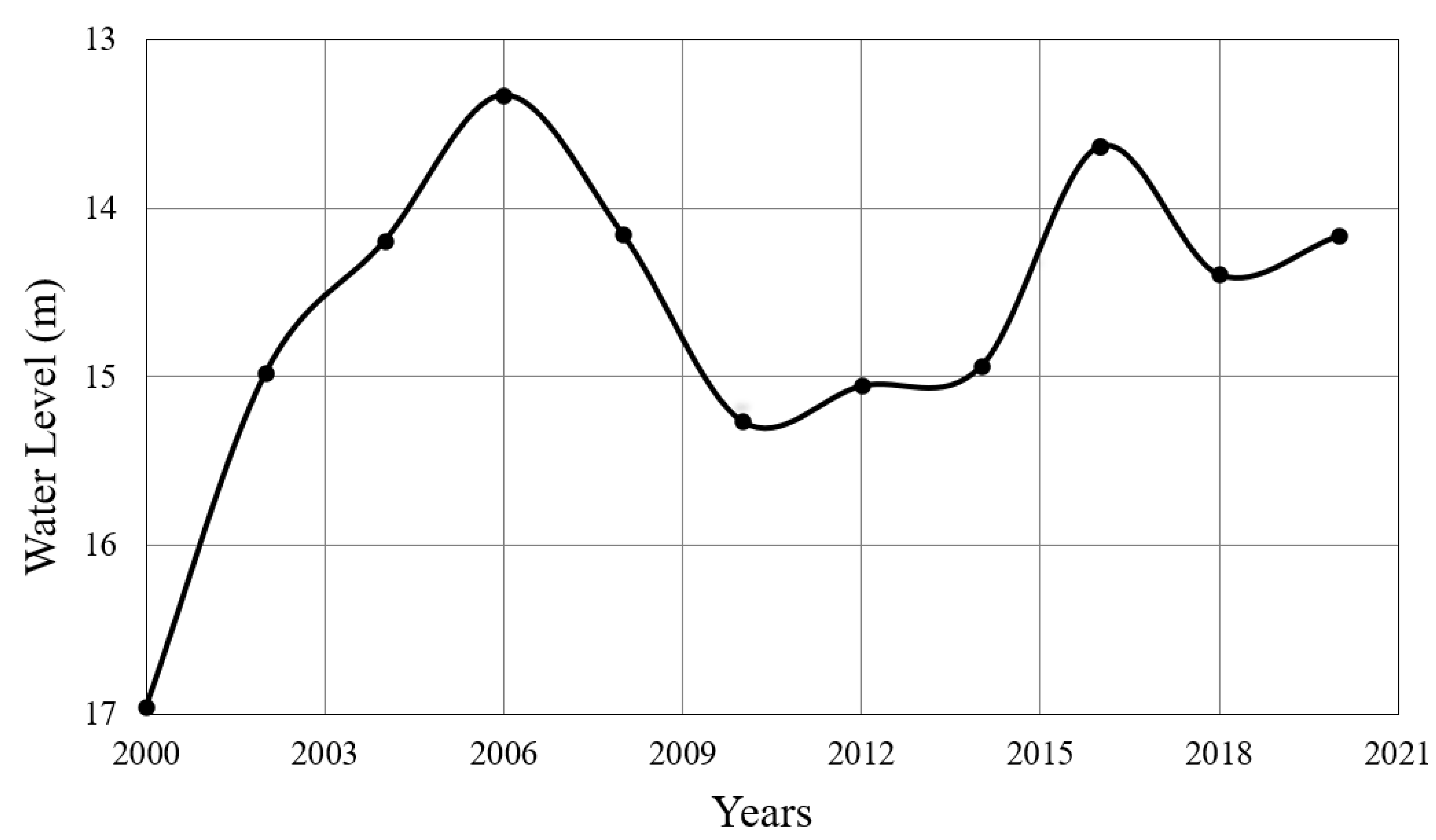
3.1. Potentiometric Surface Maps
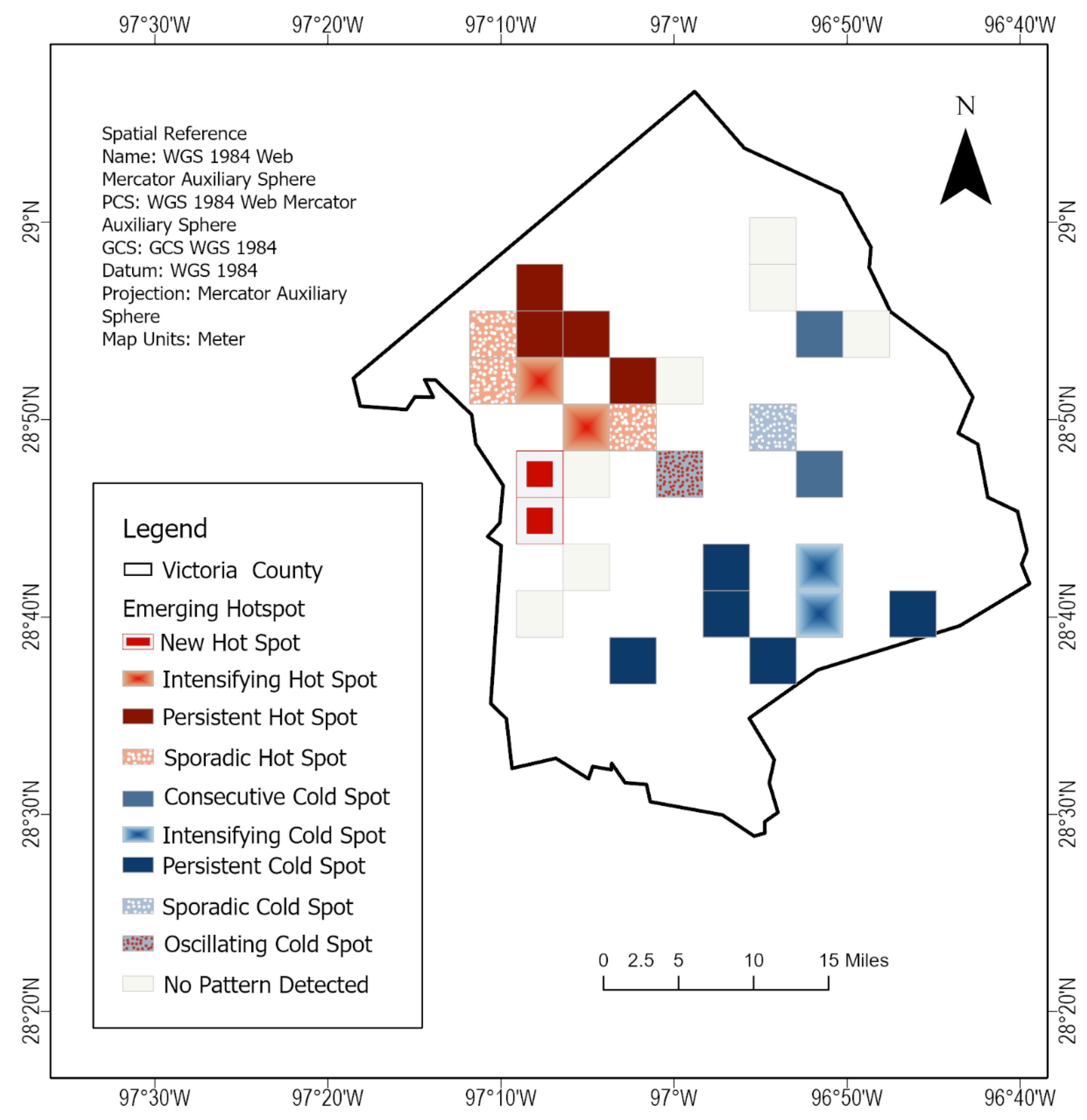
3.2. Emerging Hotspot Analysis
3.3. Optimized Hotspot Analysis
4. Conceptual Models
5. Discussion
5.1. Groundwater Change
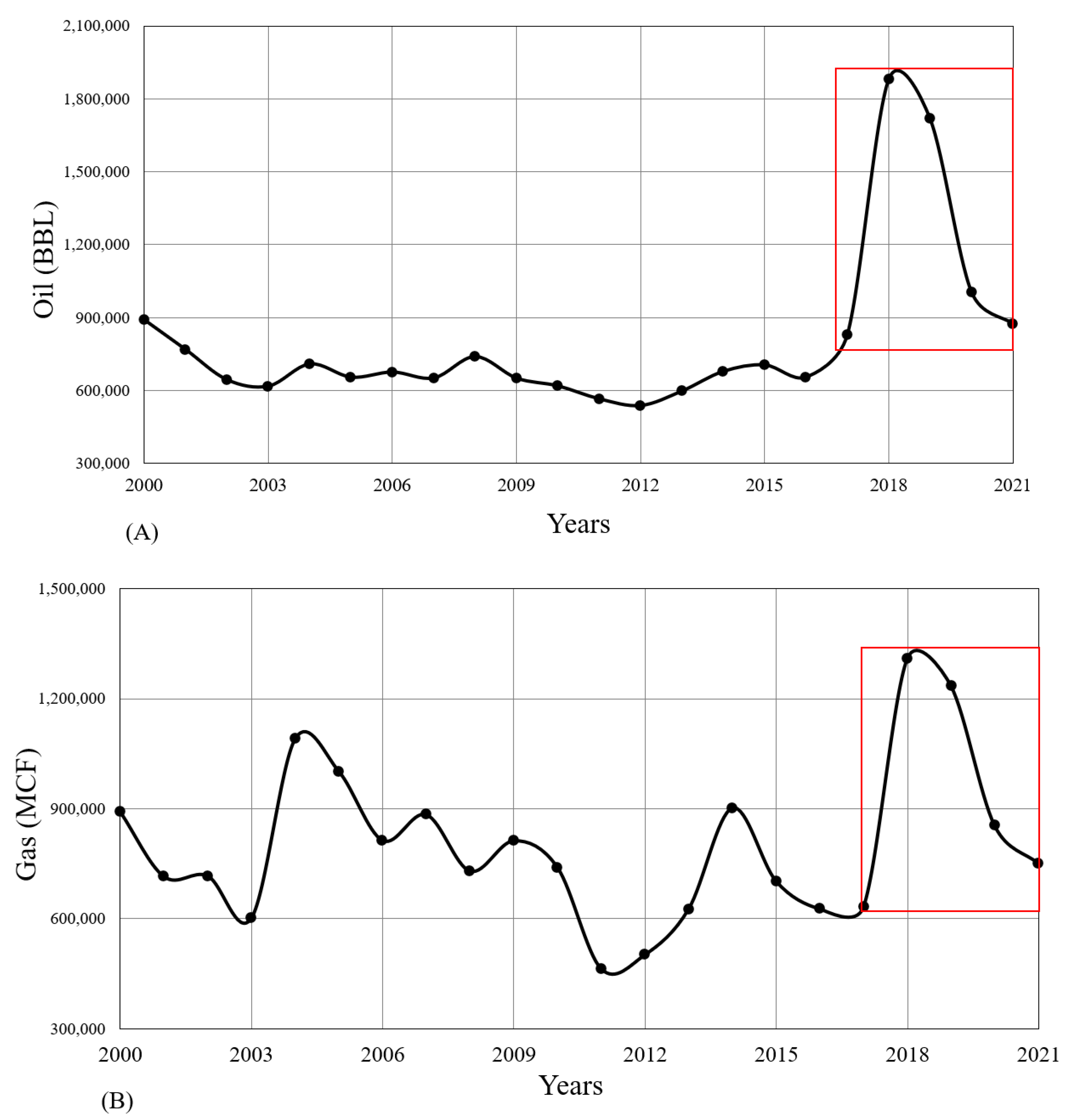
5.2. Hydrocarbon Extraction
6. Conclusions and Recommendations
- controlling the overexploitation of water and pumping of oil and gas;
- minimizing hydrocarbon exploitation or use injection to avoid more subsidence of land and saline intrusion of aquifers;
- conducting a study of the vulnerabilities of coastal aquifers;
- better planning for the management, development, and sustainability of these coastal aquifers;
- simulation modeling of these aquifers using MODFLOW and computational methods.
Author Contributions
Funding
Data Availability Statement
Acknowledgments
Conflicts of Interest
References
- Khan, S.D.; Gadea, O.C.A.; Alvarado, A.T.; Tirmizi, O.A. Surface Deformation Analysis of the Houston Area Using Time Series Interferometry and Emerging Hot Spot Analysis. Remote Sens. 2022, 14, 3831. [Google Scholar] [CrossRef]
- Ortega-Guerrero, A.; Rudolph, D.L.; Cherry, J.A. Analysis of Long-Term Land Subsidence near Mexico City: Field Investigations and Predictive Modeling. Water Resour. Res. 1999, 35, 3327–3341. [Google Scholar] [CrossRef]
- Hamed, Y.; Redhaounia, B.; Sâad, A.B.; Hadji, R.; Zahri, F.; Hidouri, B.E. Groundwater Inrush Caused by the Fault Reactivation and the Climate Impact in the Mining Gafsa Basin (Southwestern Tunisia). J. Tethys 2017, 5, 154–164. [Google Scholar]
- Hamed, Y.; Ahmadi, R.; Hadji, R.; Mokadem, N.; Dhia, H.B.; Ali, W. Groundwater Evolution of the Continental Intercalaire Aquifer of Southern Tunisia and a Part of Southern Algeria: Use of Geochemical and Isotopic Indicators. Desalinat. Water Treat. 2014, 52, 1990–1996. [Google Scholar] [CrossRef]
- Besser, H.; Hamed, Y. Causes and Risk Evaluation of Oil and Brine Contamination in the Lower Cretaceous Continental Intercalaire Aquifer in the Kebili Region of Southern Tunisia Using Chemical Fingerprinting Techniques. Environ. Pollut. 2019, 253, 412–423. [Google Scholar] [CrossRef] [PubMed]
- Hadji, R.; Boumazbeur, A.E.; Limani, Y.; Baghem, M.; Chouabi, A.e.M.; Demdoum, A. Geologic, Topographic and Climatic Controls in Landslide Hazard Assessment Using GIS Modeling: A Case Study of Souk Ahras Region, NE Algeria. Quat. Int. 2013, 302, 224–237. [Google Scholar] [CrossRef]
- Bergado, D.T.; Nutalaya, P.; Balasubramaniam, A.S.; Apaipong, W.; Chang, C.-C.; Khaw, L.G. Causes, Effects, and Predictions of Land Subsidence in AIT Campus, Chao Phraya Plain, Bangkok, Thailand. Environ. Eng. Geosci. 1988, 25, 57–81. [Google Scholar] [CrossRef]
- Carbognin, L. Interventions to Safeguard the Environment of the Venice Lagoon against the Effects of Land Elevation Loss. In Proceedings of the 6, International Symposium on Land Subsidence, Ravenna, Italia, 24–29 September 2000. [Google Scholar]
- Tosi, L.; Teatini, P.; Strozzi, T. Natural versus Anthropogenic Subsidence of Venice. Sci. Rep. 2013, 3, 2710. [Google Scholar] [CrossRef] [Green Version]
- Xue, Y.-Q.; Zhang, Y.; Ye, S.-J.; Wu, J.-C.; Li, Q.-F. Land Subsidence in China. Environ. Geol. 2005, 48, 713–720. [Google Scholar] [CrossRef]
- Small, C.; Nicholls, R.J. A Global Analysis of Human Settlement in Coastal Zones. J. Coast. Res. 2003, 19, 584–599. [Google Scholar]
- Dolan, A.H.; Walker, I.J. Understanding Vulnerability of Coastal Communities to Climate Change Related Risks. J. Coast. Res. 2006, S139, 1316–1323. [Google Scholar]
- Felsenstein, D.; Lichter, M. Social and Economic Vulnerability of Coastal Communities to Sea-Level Rise and Extreme Flooding. Nat. Hazards 2014, 71, 463–491. [Google Scholar] [CrossRef]
- Hamed, Y.; Hadji, R.; Redhaounia, B.; Zighmi, K.; Bâali, F.; El Gayar, A. Climate Impact on Surface and Groundwater in North Africa: A Global Synthesis of Findings and Recommendations. Euro-Mediterr. J. Environ. Integr. 2018, 3, 25. [Google Scholar] [CrossRef]
- Wu, S.-Y.; Yarnal, B.; Fisher, A. Vulnerability of Coastal Communities to Sea-Level Rise: A Case Study of Cape May County, New Jersey, USA. Clim. Res. 2002, 22, 255–270. [Google Scholar] [CrossRef] [Green Version]
- Qureshi, K.A.; Khan, S.D. Active Tectonics of the Frontal Himalayas: An Example from the Manzai Ranges in the Recess Setting, Western Pakistan. Remote Sens. 2020, 12, 3362. [Google Scholar] [CrossRef]
- Chen, F.-W.; Liu, C.-W. Estimation of the Spatial Rainfall Distribution Using Inverse Distance Weighting (IDW) in the Middle of Taiwan. Paddy Water Environ. 2012, 10, 209–222. [Google Scholar] [CrossRef]
- Zilkoski, D.B.; Hall, L.W.; Mitchell, G.J.; Kammula, V.; Singh, A.; Chrismer, W.M.; Neighbours, R.J. The Harris-Galveston Coastal Subsidence District/National Geodetic Survey Automated Global Positioning System Subsidence Monitoring Project. In Proceedings of the US Geological Survey Subsidence Interest Group Conference, Reston, VA, USA, 1 November 2003. [Google Scholar]
- Khan, S.D.; Huang, Z.; Karacay, A. Study of Ground Subsidence in Northwest Harris County Using GPS, LiDAR, and InSAR Techniques. Nat. Hazards 2014, 73, 1143–1173. [Google Scholar] [CrossRef]
- Qu, F.; Lu, Z.; Zhang, Q.; Bawden, G.W.; Kim, J.-W.; Zhao, C.; Qu, W. Mapping Ground Deformation over Houston–Galveston, Texas Using Multi-Temporal InSAR. Remote Sens. Environ. 2015, 169, 290–306. [Google Scholar] [CrossRef]
- Zahran, E.-S.M.M.; Shams, S.; Safwanah, S.N.B.M. Validation of Forest Fire Hotspot Analysis in GIS Using Forest Fire Contributory Factors. Syst. Rev. Pharm. 2020, 11, 249–255. [Google Scholar]
- Farid, H.U.; Ayub, H.U.; Khan, Z.M.; Ahmad, I.; Anjum, M.N.; Kanwar, R.M.A.; Mubeen, M.; Sakinder, P. Groundwater Quality Risk Assessment Using Hydro-Chemical and Geospatial Analysis. Environ. Dev. Sustain. 2022, 1–23. [Google Scholar] [CrossRef]
- Sahu, U.; Wagh, V.; Mukate, S.; Kadam, A.; Patil, S. Applications of Geospatial Analysis and Analytical Hierarchy Process to Identify the Groundwater Recharge Potential Zones and Suitable Recharge Structures in the Ajani-Jhiri Watershed of North Maharashtra, India. Groundw. Sustain. Dev. 2022, 17, 100733. [Google Scholar] [CrossRef]
- da Silva, C.F.A.; Silva, M.C.; Dos Santos, A.M.; Rudke, A.P.; Bonfim, C.V.d.; Portis, G.T.; Junior, P.M.d.A.; Coutinho, M.B.d.S. Spatial Analysis of Socio-Economic Factors and Their Relationship with the Cases of COVID-19 in Pernambuco, Brazil. Trop. Med. Int. Health 2022, 27, 397–407. [Google Scholar] [CrossRef] [PubMed]
- Sun, H.; Wang, A.; He, S. Temporal and Spatial Analysis of Alzheimer’s Disease Based on an Improved Convolutional Neural Network and a Resting-State FMRI Brain Functional Network. Int. J. Environ. Res. Public Health 2022, 19, 4508. [Google Scholar] [CrossRef] [PubMed]
- Sung, B. A Spatial Analysis of the Effect of Neighborhood Contexts on Cumulative Number of Confirmed Cases of COVID-19 in U.S. Counties through October 20 2020. Prev. Med. 2021, 147, 106457. [Google Scholar] [CrossRef] [PubMed]
- Hosseinzadeh, A.; Algomaiah, M.; Kluger, R.; Li, Z. Spatial Analysis of Shared E-Scooter Trips. J. Transp. Geogr. 2021, 92, 103016. [Google Scholar] [CrossRef]
- Hankach, P.; Gastineau, P.; Vandanjon, P.-O. Multi-Scale Spatial Analysis of Household Car Ownership Using Distance-Based Moran’s Eigenvector Maps: Case Study in Loire-Atlantique (France). J. Transp. Geogr. 2022, 98, 103223. [Google Scholar] [CrossRef]
- Matuszelański, K.; Kopczewska, K. Customer Churn in Retail E-Commerce Business: Spatial and Machine Learning Approach. J. Theor. Appl. Electron. Commer. Res. 2022, 17, 165–198. [Google Scholar] [CrossRef]
- Prastowo, P.; Putriani, D. Spatial Analysis on the Impact of Islamic Regional Financial Depth on Income Inequality in Indonesia. J. Ekon. Keuang. Islam 2022, 8, 152–166. [Google Scholar] [CrossRef]
- Betty, E.L.; Bollard, B.; Murphy, S.; Ogle, M.; Hendriks, H.; Orams, M.B.; Stockin, K.A. Using Emerging Hot Spot Analysis of Stranding Records to Inform Conservation Management of a Data-Poor Cetacean Species. Biodivers. Conserv. 2020, 29, 643–665. [Google Scholar] [CrossRef]
- Chambers, S.N. The Spatiotemporal Forming of a State of Exception: Repurposing Hot-Spot Analysis to Map Bare-Life in Southern Arizona’s Borderlands. GeoJournal 2020, 85, 1373–1384. [Google Scholar] [CrossRef]
- Xu, B.; Qi, B.; Ji, K.; Liu, Z.; Deng, L.; Jiang, L. Emerging Hot Spot Analysis and the Spatial–Temporal Trends of NDVI in the Jing River Basin of China. Environ. Earth Sci. 2022, 81, 55. [Google Scholar] [CrossRef]
- Harris, N.L.; Goldman, E.; Gabris, C.; Nordling, J.; Minnemeyer, S.; Ansari, S.; Lippmann, M.; Bennett, L.; Raad, M.; Hansen, M.; et al. Using Spatial Statistics to Identify Emerging Hot Spots of Forest Loss. Environ. Res. Lett. 2017, 12, 024012. [Google Scholar] [CrossRef] [Green Version]
- Anderson, M.P.; Woessner, W.W.; Hunt, R.J. Applied Groundwater Modeling: Simulation of Flow and Advective Transport; Academic Press: Cambridge, MA, USA, 2015; ISBN 9780080916385. [Google Scholar]
- Meyer, P.D.; Gee, G.W.; Nicholson, T.J. Information on Hydrologic Conceptual Models, Parameters, Uncertainty Analysis, and Data Sources for Dose Assessments at Decommissioning Sites; Office of Scientific and Technical Information (OSTI): Richland, WA, USA, 2000.
- Stoeser, D.B.; Shock, N.; Green, G.N.; Dumonceaux, G.M.; Heran, W.D. Data Series; Geologic Map Database of Texas; Geological Survey: Reston, VA, USA, 2005. [CrossRef]
- Haley, M.; Ahmed, M.; Gebremichael, E.; Murgulet, D.; Starek, M. Land Subsidence in the Texas Coastal Bend: Locations, Rates, Triggers, and Consequences. Remote Sens. 2022, 14, 192. [Google Scholar] [CrossRef]
- Chowdhury, A.H.; Mace, R.E. Texas Water Development Board Report; Mace Groundwater Models of the Gulf Coast Aquifer of Texas: Aquifers of the Gulf Coast of Texas; Texas Water Development Board: Austin, TX, USA, 2006.
- Baker, E.T. Stratigraphic and Hydrogeologic Framework of Part of the Coastal Plain of Texas; Texas Department of Water Resources: Austin, TX, USA, 1979.
- Texas Water Development Board. Available online: https://www3.twdb.texas.gov/apps/waterdatainteractive/groundwaterdataviewer (accessed on 15 August 2022).
- Homeland Infrastructure Foundation Level. Available online: https://hifld-geoplatform.opendata.arcgis.com/ (accessed on 15 August 2022).
- Adamson, J.K.; Miner, W.J.; Rochat, P.-Y.; Moliere, E.; Piasecki, M.; LaVanchy, G.T.; Perez-Monforte, S.; Rodriquez-Vera, M. Significance of River Infiltration to the Port-Au-Prince Metropolitan Region: A Case Study of Two Alluvial Aquifers in Haiti. Hydrogeol. J. 2022, 30, 1367–1386. [Google Scholar] [CrossRef]
- Miller, H.J. Tobler’s First Law and Spatial Analysis. Ann. Assoc. Am. Geogr. 2004, 94, 284–289. [Google Scholar] [CrossRef]
- Isaaks, E.H.; Srivastava, R.M. Applied Geostatistics; Oxford University Press: New York, NY, USA, 1989; Volume 2. [Google Scholar]
- Chainey, S.; Ratcliffe, J. GIS and Crime Mapping; Chainey, S., Ratcliffe, J., Eds.; Wiley: New York, NY, USA, 2013; ISBN 9781118685198. [Google Scholar]
- Openshaw, S. Ecological Fallacies and the Analysis of Areal Census Data. Environ. Plan. A Econ. Space 1984, 16, 17–31. [Google Scholar] [CrossRef] [Green Version]
- Chainey, S. Examining the Extent to Which Hotspot Analysis Can Support Spatial Predictions of Crime. Ph.D. Thesis, UCL University College London, London, UK, 2014. [Google Scholar]
- Ord, J.K.; Getis, A. Local Spatial Autocorrelation Statistics: Distributional Issues and an Application. Geogr. Anal. 1995, 27, 286–306. [Google Scholar] [CrossRef]
- Getis, A.; Ord, J.K. The Analysis of Spatial Association by Use of Distance Statistics. In Perspectives on Spatial Data Analysis; Anselin, L., Rey, S.J., Eds.; Springer: Berlin/Heidelberg, Germany, 2010; pp. 127–145. ISBN 9783642019760. [Google Scholar]
- Kraak The Space-Time Cube Revisited from a Geovisualization Perspective. In Proceedings of the 21st International Cartographic Conference, Enschede, The Netherlands, 10–16 August 2003.
- ESRI. Available online: https://desktop.arcgis.com/en/arcmap/10.7/tools/spatial-statistics-toolbox/how-optimized-hot-spot-analysis-works.htm (accessed on 28 August 2022).
- Stappers, N.E.H.; Schipperijn, J.; Kremers, S.P.J.; Bekker, M.P.M.; Jansen, M.W.J.; de Vries, N.K.; Van Kann, D.H.H. Visualizing Changes in Physical Activity Behavioral Patterns after Redesigning Urban Infrastructure. Health Place 2022, 76, 102853. [Google Scholar] [CrossRef]
- Lu, P.; Bai, S.; Tofani, V.; Casagli, N. Landslides Detection through Optimized Hot Spot Analysis on Persistent Scatterers and Distributed Scatterers. ISPRS J. Photogramm. Remote Sens. 2019, 156, 147–159. [Google Scholar] [CrossRef]
- Mashinini, D.P.; Fogarty, K.J.; Potter, R.C.; Berles, J.D. Geographic Hot Spot Analysis of Vaccine Exemption Clustering Patterns in Michigan from 2008 to 2017. Vaccine 2020, 38, 8116–8120. [Google Scholar] [CrossRef]
- Wang, D.; Ding, W.; Lo, H.; Stepinski, T.; Salazar, J.; Morabito, M. Crime Hotspot Mapping Using the Crime Related Factors—A Spatial Data Mining Approach. Appl. Intell. 2013, 39, 772–781. [Google Scholar] [CrossRef]
- Neville, J.A.; Guz, J.; Rosko, H.M.; Owens, M.C. Water Quality Inequality: A Non-Targeted Hotspot Analysis for Ambient Water Quality Injustices. Hydrol. Sci. J. 2022, 67, 1011–1025. [Google Scholar] [CrossRef]
- Patel, R.S.; Walker, T.; Weber, Z.T.; Kelley, S.D.; Hansen, R. A Pilot Study Using Geospatial Analysis to Identify Hot-Spot of Populations Utilizing Services at University Based Counseling Centers. J. Am. Coll. Health 2022, 70, 1280–1285. [Google Scholar] [CrossRef] [PubMed]
- Izady, A.; Davary, K.; Alizadeh, A.; Ziaei, A.N.; Alipoor, A.; Joodavi, A.; Brusseau, M.L. A Framework toward Developing a Groundwater Conceptual Model. Arab. J. Geosci. 2014, 7, 3611–3631. [Google Scholar] [CrossRef]
- Zhou, Y.; Li, W. A Review of Regional Groundwater Flow Modeling. Geosci. Front. 2011, 2, 205–214. [Google Scholar] [CrossRef] [Green Version]
- Gillespie, J.; Nelson, S.T.; Mayo, A.L.; Tingey, D.G. Why Conceptual Groundwater Flow Models Matter: A Trans-Boundary Example from the Arid Great Basin, Western USA. Hydrogeol. J. 2012, 20, 1133–1147. [Google Scholar] [CrossRef]
- Gabrysch, R.K. Ground-Water Withdrawals and Land-Surface Subsidence in the Houston-Galveston Region, Texas, 1906–1980; U.S. Geological Survey: Reston, VA, USA, 1982. [CrossRef] [Green Version]
- Gyawali, B.; Murgulet, D.; Ahmed, M. Quantifying Changes in Groundwater Storage and Response to Hydroclimatic Extremes in a Coastal Aquifer Using Remote Sensing and Ground-Based Measurements the Texas Gulf Coast Aquifer. Remote Sens. 2022, 14, 612. [Google Scholar] [CrossRef]
- Galloway, D.L.; Burbey, T.J. Review: Regional Land Subsidence Accompanying Groundwater Extraction. Hydrogeol. J. 2011, 19, 1459–1486. [Google Scholar] [CrossRef]
- Holzer, T.L.; Galloway, D.L. Impacts of Land Subsidence Caused by Withdrawal of Underground Fluids in the United States. In Humans as Geologic Agents; Ehlen, J., Haneberg, W., Larson, R., Eds.; The Geological Society of America: Boulder, CO, USA, 2005; Volume 16. [Google Scholar]
- Wu, J.-C.; Shi, X.-Q.; Ye, S.-J.; Xue, Y.-Q.; Zhang, Y.; Yu, J. Numerical Simulation of Land Subsidence Induced by Groundwater Overexploitation in Su-Xi-Chang Area, China. Environ. Geol. 2009, 57, 1409–1421. [Google Scholar] [CrossRef]
- Pratt, W.E.; Johnson, D.W. Local Subsidence of the Goose Creek Oil Field. J. Geol. 1926, 34, 577–590. [Google Scholar] [CrossRef]
- Morton, R.A.; Buster, N.A.; Krohn, D.M. Subsurface Controls on Historical Subsidence Rates and Associated Wetland Loss in Southcentral Louisiana. Gulf Coast Assoc. Geol. Soc. 2002, 52, 767–778. [Google Scholar]
- White, W.A.; Morton, R.A. Wetland Losses Related to Fault Movement and Hydrocarbon Production, Southeastern Texas Coast. J. Coast. Res. 1997, 13, 1305–1320. [Google Scholar]
- Sharp, J.M.; Hill, D.W. Land Subsidence along the Northeastern Texas Gulf Coast: Effects of Deep Hydrocarbon Production. Environ. Geol. 1995, 25, 181–191. [Google Scholar] [CrossRef]
- Colazas, X.C.; Strehle, R.W. Subsidence in the Wilmington Oil Field, Long Beach, California, USA. In Developments in Petroleum Science; Chilingarian, G.V., Donaldson, E.C., Yen, T.F., Eds.; Elsevier: Amsterdam, The Netherlands, 1995; Volume 41, pp. 285–335. [Google Scholar]
- Mayuga, M.N.; Allen, D.R. Subsidence in the Wilmington Oil Field, Long Beach, California, USA. In Proceedings of the Tokyo Symposium on Land Subsidence, International Association of Scientific Hydrology, Studies and Reports in Hydrology, U.S. Coast and Geodetic Survey, Washington, DC, USA, 17 September 1969. [Google Scholar]
- Nagel, N.B. Ekofisk Field Overburden Modelling. In Proceedings of the SPE/ISRM Rock Mechanics in Petroleum Engineering, Trondheim, Norway, 8 July 1998. [Google Scholar]
- Fokker, P.A.; Orlic, B. Semi-Analytic Modelling of Subsidence. Math. Geol. 2006, 38, 565–589. [Google Scholar] [CrossRef]


Publisher’s Note: MDPI stays neutral with regard to jurisdictional claims in published maps and institutional affiliations. |
© 2022 by the authors. Licensee MDPI, Basel, Switzerland. This article is an open access article distributed under the terms and conditions of the Creative Commons Attribution (CC BY) license (https://creativecommons.org/licenses/by/4.0/).
Share and Cite
Younas, M.; Khan, S.D.; Qasim, M.; Hamed, Y. Assessing Impacts of Land Subsidence in Victoria County, Texas, Using Geospatial Analysis. Land 2022, 11, 2211. https://doi.org/10.3390/land11122211
Younas M, Khan SD, Qasim M, Hamed Y. Assessing Impacts of Land Subsidence in Victoria County, Texas, Using Geospatial Analysis. Land. 2022; 11(12):2211. https://doi.org/10.3390/land11122211
Chicago/Turabian StyleYounas, Muhammad, Shuhab D. Khan, Muhammad Qasim, and Younes Hamed. 2022. "Assessing Impacts of Land Subsidence in Victoria County, Texas, Using Geospatial Analysis" Land 11, no. 12: 2211. https://doi.org/10.3390/land11122211
APA StyleYounas, M., Khan, S. D., Qasim, M., & Hamed, Y. (2022). Assessing Impacts of Land Subsidence in Victoria County, Texas, Using Geospatial Analysis. Land, 11(12), 2211. https://doi.org/10.3390/land11122211