
Estimation and Dynamic Analysis of Soil Salinity Based on UAV and Sentinel-2A Multispectral Imagery in the Coastal Area, China


Abstract
:1. Introduction
2. Materials and Methods
2.1. Study Area
2.2. Data Acquisition and Preprocessing
2.2.1. Soil Salinity Data
2.2.2. UAV Multispectral Imagery Data
2.2.3. Sentinel-2A Multispectral Imagery Data
2.2.4. Land Use Data
2.3. Selection of Sensitive Bands and Spectral Parameters of Soil Salinity
2.4. Construction and Verification of Estimation Model for Soil Salinity
3. Results and Analysis
3.1. Construction of Soil Salinity Prediction Model Based on UAV Multispectral Imagery
3.1.1. Salt-Sensitive Spectral Parameters of UAV
3.1.2. Construction of Soil Salt Prediction Model
- (1)
- Construction of estimation model based on band reflectivity
- (2)
- Construction of estimation model based on vegetation index
- (3)
- Construction of estimation model based on soil salinity index
- (4)
- Construction of a comprehensive estimation model for soil salinity
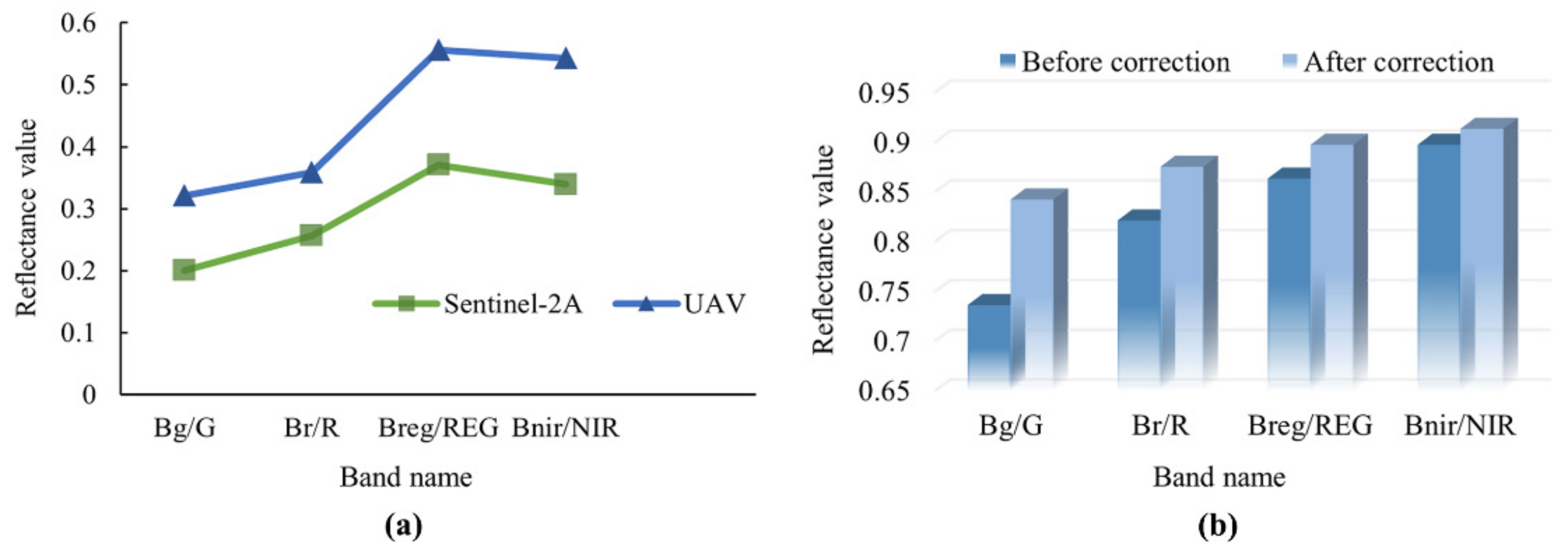
3.2. Reflectance Correction of Sentinel-2A Multispectral Imagery
3.3. Verification and Estimation of the Best Prediction Model of Soil Salinity
3.3.1. Verification of the Best Prediction Model
3.3.2. Estimation of Soil Salinity
- (1)
- Estimation of soil salinity in test area based on UAV multispectral imagery
- (2)
- Retrieval of soil salinity in the study area based on Sentinel-2A satellite imagery
3.4. Soil Salinity Dynamics in the YRD
3.4.1. Temporal Variation of Soil Salinity
3.4.2. The Ground Feature Stability of Saline Soil
4. Discussion
4.1. Estimation Method and Accuracy Verification of Soil Salinity
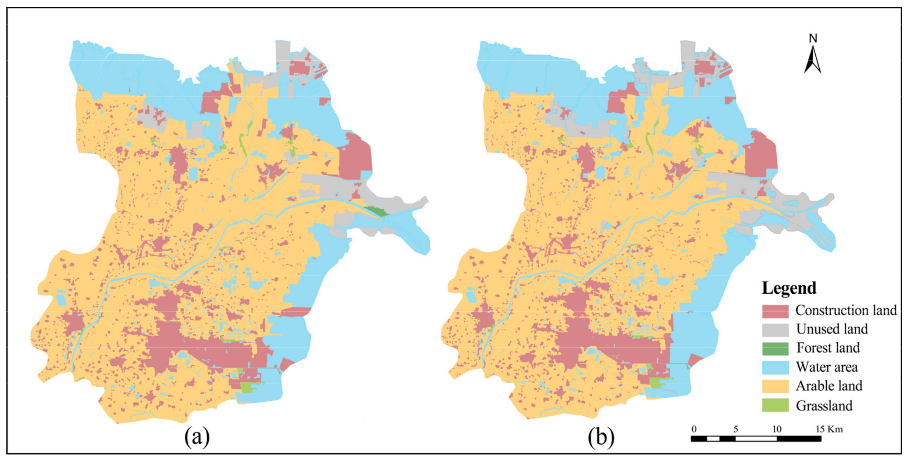
4.2. Soil Salinity Dynamics and Its Relationship with Land Use
5. Conclusions
- (1)
- Among the different spectral indices, some single bands, vegetation indices, and salinity indices, which are more sensitive to soil salinity, were screened. The BPNN modeling method (R2 = 0.769, RMSE = 2.342 for the modelling set; R2 = 0.774, RMSE = 2.475, RPD = 1.799 for the validation set) and the comprehensive estimation model had the best predicting effect of soil salinity in the Yellow River Delta region.
- (2)
- Sentinel-2A satellite imagery and UAV imagery reflectance correction can solve the problem of band reflectance and correlation in multi-source data fusion.
- (3)
- The anomalous values of the estimation results were within 10% and 15% in the test area and study area during 2016–2019, which was consistent with the actual situation. Meanwhile, it shows that the best prediction model of this study can, to a certain extent, realize large-scale estimation of satellite imagery of different periods after reflectance correction.
Author Contributions
Funding
Data Availability Statement
Acknowledgments
Conflicts of Interest
References
- Fan, X.; Pedroli, B.; Liu, G.; Liu, Q.; Liu, H.; Shu, L. Soil salinity development in the yellow river delta in relation to groundwater dynamics. Land Degrad. Dev. 2012, 23, 175–189. [Google Scholar] [CrossRef]
- Lu, Q.S.; Kang, L.Y.; Shao, H.B.; Zhao, Z.P.; Chen, Q.; Bi, X.L.; Shi, P. Investigating marsh sediment dynamics and its driving factors in Yellow River delta for wetland restoration. Ecol. Eng. 2016, 90, 307–313. [Google Scholar] [CrossRef]
- Chen, H.Y.; Zhao, G.X.; Li, Y.H.; Wang, D.Y.; Ma, Y. Monitoring the seasonal dynamics of soil salinization in the Yellow River delta of China using Landsat data. Nat. Hazards Earth Syst. Sci. 2019, 19, 1499–1508. [Google Scholar] [CrossRef] [Green Version]
- Ma, Y.; Chen, H.Y.; Zhao, G.X.; Wang, Z.R.; Wang, D.Y. Spectral Index Fusion for Salinized Soil Salinity Inversion Using Sentinel-2A and UAV Images in a Coastal Area. IEEE Access 2020, 8, 159595–159608. [Google Scholar] [CrossRef]
- Guo, B.; Zang, W.Q.; Luo, W.; Wen, Y.; Yang, F.; Han, B.M.; Fan, Y.W.; Chen, X.; Qi, Z.; Wang, Z.; et al. Detection model of soil salinization information in the Yellow River Delta based on feature space models with typical surface parameters derived from Landsat8 OLI image. Geomat. Nat. Hazards Risk 2020, 11, 288–300. [Google Scholar] [CrossRef]
- Sun, H.Z.; Xu, L.R.; Wang, J.; Fu, X. Remote Sensing Monitoring of Spatial-Temporal Variation of Soil Salinization before and after Irrigation in the Yellow River Delta. J. Coast. Res. 2020, 105, 56–60. [Google Scholar] [CrossRef]
- Wang, J.Z.; Ding, J.L.; Yu, D.L.; Ma, X.K.; Zhang, Z.P.; Ge, X.Y.; Teng, D.X.; Li, X.H.; Liang, J.; Lizag, A.; et al. Capability of Sentinel-2 MSI data for monitoring and mapping of soil salinity in dry and wet seasons in the Ebinur Lake region, Xinjiang, China. Geoderma 2019, 353, 172–187. [Google Scholar] [CrossRef]
- Xu, C.; Zeng, W.Z.; Huang, J.S.; Wu, J.W.; van Leeuwen, W.J.D. Prediction of Soil Moisture Content and Soil Salt Concentration from Hyperspectral Laboratory and Field Data. Remote Sens. 2016, 8, 42. [Google Scholar] [CrossRef] [Green Version]
- Meng, B.P.; Ge, J.; Liang, T.G.; Yang, S.X.; Gao, J.L.; Feng, Q.S.; Cui, X.; Huang, X.D.; Xie, H.J. Evaluation of Remote Sensing Inversion Error for the Above-Ground Biomass of Alpine Meadow Grassland Based on Multi-Source Satellite Data. Remote Sens. 2017, 9, 372. [Google Scholar] [CrossRef] [Green Version]
- Hu, X.; Niu, B.B.; Li, X.J.; Min, X.Y. Unmanned aerial vehicle (UAV) remote sensing estimation of wheat chlorophyll in subsidence area of coal mine with high phreatic level. Earth Sci. Inf. 2021, 14, 2171–2181. [Google Scholar] [CrossRef]
- Wang, N.; Xue, J.; Peng, J.; Biswas, A.; He, Y.; Shi, Z. Integrating Remote Sensing and Landscape Characteristics to Estimate Soil Salinity Using Machine Learning Methods: A Case Study from Southern Xinjiang, China. Remote Sens. 2020, 12, 4118. [Google Scholar] [CrossRef]
- Wei, G.F.; Li, Y.; Zhang, Z.T.; Chen, Y.W.; Chen, J.Y.; Yao, Z.H.; Lao, C.C.; Chen, H.F. Estimation of soil salt content by combining UAV-borne multispectral sensor and machine learning algorithms. Peerj 2020, 8, e9087. [Google Scholar] [CrossRef]
- Zhao, D.X.; Wang, J.; Zhao, X.Y.; Triantafilis, J. Clay content mapping and uncertainty estimation using weighted model averaging. Catena 2022, 209, 14. [Google Scholar] [CrossRef]
- Zhao, W.J.; Zhou, C.; Zhou, C.Q.; Ma, H.; Wang, Z.J. Soil Salinity Inversion Model of Oasis in Arid Area Based on UAV Multispectral Remote Sensing. Remote Sens. 2022, 14, 1804. [Google Scholar] [CrossRef]
- Huang, J.; Koganti, T.; Santos, F.A.M.; Triantafilis, J. Mapping soil salinity and a fresh-water intrusion in three-dimensions using a quasi-3d joint-inversion of DUALEM-421S and EM34 data. Sci. Total Environ. 2017, 577, 395–404. [Google Scholar] [CrossRef]
- Zhao, D.X.; Li, N.; Zare, E.; Wang, J.; Triantafilis, J. Mapping cation exchange capacity using a quasi-3d joint inversion of EM38 and EM31 data. Soil Tillage Res. 2020, 200, 12. [Google Scholar] [CrossRef]
- El Hajj, M.; Baghdadi, N.; Zribi, M.; Bazzi, H. Synergic Use of Sentinel-1 and Sentinel-2 Images for Operational Soil Moisture Mapping at High Spatial Resolution over Agricultural Areas. Remote Sens. 2017, 9, 1292. [Google Scholar] [CrossRef] [Green Version]
- Sui, J.; Qin, Q.M.; Ren, H.Z.; Sun, Y.H.; Zhang, T.Y.; Wang, J.D.; Gong, S.H. Winter Wheat Production Estimation Based on Environmental Stress Factors from Satellite Observations. Remote Sens. 2018, 10, 962. [Google Scholar] [CrossRef] [Green Version]
- An, D.Y.; Zhao, G.X.; Chang, C.Y.; Wang, Z.R.; Li, P.; Zhang, T.R.; Jia, J.C. Hyperspectral field estimation and remote-sensing inversion of salt content in coastal saline soils of the Yellow River Delta. Int. J. Remote Sens. 2016, 37, 455–470. [Google Scholar] [CrossRef]
- Wang, J.Q.; Peng, J.; Li, H.Y.; Yin, C.Y.; Liu, W.Y.; Wang, T.W.; Zhang, H.P. Soil Salinity Mapping Using Machine Learning Algorithms with the Sentinel-2 MSI in Arid Areas, China. Remote Sens. 2021, 13, 305. [Google Scholar] [CrossRef]
- Wang, D.Y.; Chen, H.Y.; Wang, Z.R.; Ma, Y. Inversion of soil salinity according to different salinization grades using multi-source remote sensing. Geocarto Int. 2022, 37, 1274–1293. [Google Scholar] [CrossRef]
- Yang, N.; Yang, S.; Cui, W.X.; Zhang, Z.T.; Zhang, J.R.; Chen, J.Y.; Ma, Y.; Lao, C.C.; Song, Z.S.; Chen, Y.W. Effect of spring irrigation on soil salinity monitoring with UAV-borne multispectral sensor. Int. J. Remote Sens. 2021, 42, 8952–8978. [Google Scholar] [CrossRef]
- Mandal, A.K. The need for the spectral characterization of dominant salts and recommended methods of soil sampling and analysis for the proper spectral evaluation of salt affected soils using hyper -spectral remote sensing. Remote Sens. Lett. 2022, 13, 588–598. [Google Scholar] [CrossRef]
- Shrestha, R.P. Relating soil electrical conductivity to remote sensing and other soil properties for assessing soil salinity in northeast Thailand. Land Degrad Dev. 2006, 17, 677–689. [Google Scholar] [CrossRef]
- Allbed, A.; Kumar, L.; Aldakheel, Y.Y. Assessing soil salinity using soil salinity and vegetation indices derived from IKONOS high-spatial resolution imageries: Applications in a date palm dominated region. Geoderma 2014, 230, 1–8. [Google Scholar] [CrossRef]
- Zhou, X.H.; Zhang, F.; Zhang, H.W.; Zhang, X.L.; Yuan, J. A Study of Soil Salinity Inversion Based on Multispectral Remote Sensing Index in Ebinur Lake Wetland Nature Reserve. Spectrosc. Spect. Anal. 2019, 39, 1229–1235. [Google Scholar] [CrossRef]
- Masoud, A.A. Predicting salt abundance in slightly saline soils from Landsat ETM plus imagery using Spectral Mixture Analysis and soil spectrometry. Geoderma 2014, 217, 45–56. [Google Scholar] [CrossRef]
- Yu, H.; Liu, M.Y.; Du, B.J.; Wang, Z.M.; Hu, L.J.; Zhang, B. Mapping Soil Salinity/Sodicity by using Landsat OLI Imagery and PLSR Algorithm over Semiarid West Jilin Province, China. Sensors 2018, 18, 1048. [Google Scholar] [CrossRef] [Green Version]
- Peng, J.; Biswas, A.; Jiang, Q.S.; Zhao, R.Y.; Hu, J.; Hu, B.F.; Shi, Z. Estimating soil salinity from remote sensing and terrain data in southern Xinjiang Province, China. Geoderma 2019, 337, 1309–1319. [Google Scholar] [CrossRef]
- Wang, Y.; Xie, M.D.; Hu, B.F.; Jiang, Q.S.; Shi, Z.; He, Y.F.; Peng, J. Desert Soil Salinity Inversion Models Based on Field In Situ Spectroscopy in Southern Xinjiang, China. Remote Sens. 2022, 14, 4962. [Google Scholar] [CrossRef]
- Guo, B.; Han, B.M.; Yang, F.; Fan, Y.W.; Jiang, L.; Chen, S.T.; Yang, W.N.; Gong, R.; Liang, T. Salinization information extraction model based on VI-SI feature space combinations in the Yellow River Delta based on Landsat 8 OLI image. Geomat. Nat. Hazards Risk 2019, 10, 1863–1878. [Google Scholar] [CrossRef] [Green Version]
- Taghadosi, M.M.; Hasanlou, M.; Eftekhari, K. Retrieval of soil salinity from Sentinel-2 multispectral imagery. Eur. J. Remote Sens. 2019, 52, 138–154. [Google Scholar] [CrossRef] [Green Version]
- Wu, D.; Jia, K.L.; Zhang, X.D.; Zhang, J.H.; Abd El-Hamid, H.T. Remote Sensing Inversion for Simulation of Soil Salinization Based on Hyperspectral Data and Ground Analysis in Yinchuan, China. Nat. Resour. Res. 2021, 30, 4641–4656. [Google Scholar] [CrossRef]
- Hassani, A.; Azapagic, A.; Shokri, N. Predicting long-term dynamics of soil salinity and sodicity on a global scale. Paroc. Natl. Acad. Sci. USA 2020, 117, 33017–33027. [Google Scholar] [CrossRef]
- Wang, Z.R.; Zhao, G.X.; Gao, M.X.; Chang, C.Y. Spatial variability of soil salinity in coastal saline soil at different scales in the Yellow River Delta, China. Environ. Monit. Assess 2017, 189, 80. [Google Scholar] [CrossRef]
- Zhang, T.R.; Zhao, G.X.; Gao, M.X.; Wang, Z.R.; Jia, J.C.; Li, P.; An, D.Y. Soil Salinity Estimation Based on Near-Ground Multispectral Imagery in Typical Area of the Yellow River Delta. Spectrosc. Spect. Anal. 2016, 36, 248–253. [Google Scholar] [CrossRef]
- Bui, E.N. Soil salinity: A neglected factor in plant ecology and biogeography. J. Arid Environ. 2013, 92, 14–25. [Google Scholar] [CrossRef]
- Mau, Y.; Porporato, A. A dynamical system approach to soil salinity and sodicity. Adv. Water Resour. 2015, 83, 68–76. [Google Scholar] [CrossRef] [Green Version]
- Yao, R.J.; Yang, J.S.; Wu, D.H.; Xie, W.P.; Gao, P.; Wang, X.P. Geostatistical monitoring of soil salinity for precision management using proximally sensed electromagnetic induction (EMI) method. Environ. Earth Sci. 2016, 75, 1362. [Google Scholar] [CrossRef]
- Zhang, Z.X.; Song, Y.T.; Zhang, H.Z.; Li, X.J.; Niu, B.B. Effect of different improvement modes on physical and chemical characters of the coastal saline soil. Chin. J. Appl. Ecol. 2021, 32, 1393–1405. [Google Scholar] [CrossRef]
- Zhen, Y.; Wu, Z.P.; Yin, Z.H.; Yang, X.Q.; Zhao, X.H. Study on spatio-temporal change of land use in Zoige County, Sichuan Province. Ecol. Sci. 2022, 41, 41–49. [Google Scholar] [CrossRef]
- Zhang, C.; Lu, D.S.; Chen, X.; Zhang, Y.M.; Maisupova, B.; Tao, Y. The spatiotemporal patterns of vegetation coverage and biomass of the temperate deserts in Central Asia and their relationships with climate controls. Remote Sens. Environ. 2016, 175, 271–281. [Google Scholar] [CrossRef]
- Alhammadi, M.S.; Glenn, E.P. Detecting date palm trees health and vegetation greenness change on the eastern coast of the United Arab Emirates using SAVI. Int. J. Remote Sens. 2008, 29, 1745–1765. [Google Scholar] [CrossRef]
- Bannari, A.; El-Battay, A.; Bannari, R.; Rhinane, H. Sentinel-MSI VNIR and SWIR Bands Sensitivity Analysis for Soil Salinity Discrimination in an Arid Landscape. Remote Sens. 2018, 10, 855. [Google Scholar] [CrossRef] [Green Version]
- Huete, A.; Didan, K.; van Leeuwen, W.; Vermote, E. Global-scale analysis of vegetation indices for moderate resolution monitoring of terrestrial vegetation. In Proceedings of the Remote Sensing for Earth Science, Ocean, and Sea Ice Applications, Florence, Italy, 20–24 September 1999; Volume 3868, pp. 141–151. [Google Scholar] [CrossRef]
- Douaoui, A.E.K.; Nicolas, H.; Walter, C. Detecting salinity hazards within a semiarid context by means of combining soil and remote-sensing data. Geoderma 2006, 134, 217–230. [Google Scholar] [CrossRef]
- Abbas, A.; Khan, S.; Hussain, N.; Hanjra, M.A.; Akbar, S. Characterizing soil salinity in irrigated agriculture using a remote sensing approach. Phys. Chem. Earth 2013, 55–57, 43–52. [Google Scholar] [CrossRef]
- Khan, N.M.; Rastoskuev, V.V.; Sato, Y.; Shiozawa, S. Assessment of hydrosaline land degradation by using a simple approach of remote sensing indicators. Agr. Water Manag. 2005, 77, 96–109. [Google Scholar] [CrossRef]
- Wu, W.C. The Generalized Difference Vegetation Index (GDVI) for Dryland Characterization. Remote Sens. 2014, 6, 1211–1233. [Google Scholar] [CrossRef] [Green Version]
- Zhang, H.Y.; Fan, J.W.; Shao, Q.Q. Land use/land cover change in the grassland restoration program areas in China, 2000-2010. Prog. Geo. 2015, 34, 840–853. [Google Scholar] [CrossRef]
- Crawford, S.B.; Kosinski, A.S.; Lin, H.M.; Williamson, J.M.; Barnhart, H.X. Computer programs for the concordance correlation coefficient. Comput. Meth. Programs Biomed. 2007, 88, 62–74. [Google Scholar] [CrossRef]
- Lin, L.I. A concordance correlation coefficient to evaluate reproducibility. Biometrics 1989, 45, 255–268. [Google Scholar] [CrossRef]
- Zhang, S.M.; Zhao, G.X. A Harmonious Satellite-Unmanned Aerial Vehicle-Ground Measurement Inversion Method for Monitoring Salinity in Coastal Saline Soil. Remote Sens. 2019, 11, 1700. [Google Scholar] [CrossRef] [Green Version]
- Bian, L.L.; Wang, J.L.; Liu, J.; Han, B.M. Spatiotemporal Changes of Soil Salinization in the Yellow River Delta of China from 2015 to 2019. Sustainability 2021, 13, 822. [Google Scholar] [CrossRef]
- Qi, G.H.; Chang, C.Y.; Yang, W.; Gao, P.; Zhao, G.X. Soil Salinity Inversion in Coastal Corn Planting Areas by the Satellite-UAV-Ground Integration Approach. Remote Sens. 2021, 13, 3100. [Google Scholar] [CrossRef]
- Zare, E.; Arshad, M.; Zhao, D.X.; Nachimuthu, G.; Triantafilis, J. Two-dimensional time-lapse imaging of soil wetting and drying cycle using EM38 data across a flood irrigation cotton field. Agr. Water Manag. 2020, 241, 106383. [Google Scholar] [CrossRef]
- Liu, J.; Zhang, L.; Dong, T.; Wang, J.L.; Fan, Y.M.; Wu, H.Q.; Geng, Q.L.; Yang, Q.J.; Zhang, Z.B. The Applicability of Remote Sensing Models of Soil Salinization Based on Feature Space. Sustainability 2021, 13, 3711. [Google Scholar] [CrossRef]
- Liu, D.D.; Zhang, Y.J.; Liu, J.; Mei, X.D.; Zhao, X.M.; Zhu, J.W.; Wang, M.S.; Wang, Y.L. Study on Inversion of Soil Salinity with Hyperspectral Remote Sensing. In Proceedings of the 2016 International Conference on Environmental Science and Engineering (Ese 2016), Guilin, China, 15–17 April 2016; pp. 526–530. [Google Scholar]
- Chen, H.Y.; Ma, Y.; Zhu, A.X.; Wang, Z.R.; Zhao, G.X.; Wei, Y.A. Soil salinity inversion based on differentiated fusion of satellite image and ground spectra. Int. J. Appl. Earth Obs. 2021, 101, 102360. [Google Scholar] [CrossRef]
- Meng, L.; Zhou, S.W.; Zhang, H.; Bi, X.L. Estimating soil salinity in different landscapes of the Yellow River Delta through Landsat OLI/TIRS and ETM plus Data. J. Coast Conserv. 2016, 20, 271–279. [Google Scholar] [CrossRef]
- Zhang, M.L.; Wang, H.X.; Pang, X.K.; Liu, H.; Wang, Q. Characteristics of soil salinity in the typical area of Yellow River Delta and its control measures. IOP Conf. Ser. Earth Environ. Sci. 2017, 64, 012078. [Google Scholar] [CrossRef]
- Niu, B.B.; Zhang, Z.X.; Yu, X.Y.; Li, X.J.; Wang, Z.; Loaiciga, H.A.; Peng, S. Regime shift of the hydroclimate-vegetation system in the Yellow River Delta of China from 1982 through 2015. Environ. Res. Lett. 2020, 15, 024017. [Google Scholar] [CrossRef]


| Band Name | UAV Imagery Data (Equipped with Sequoia Agricultural Multispectral Camera) | Sentinel-2A Imagery Data | |||
|---|---|---|---|---|---|
| Band | Center Wavelength (nm) | FWHM | Band | Center Wavelength (nm) | |
| Bg | B1-Green | 550 | 20 | B3-Green | 560 |
| Br | B2-Red | 660 | 20 | B4-Red | 665 |
| Breg1 | - | - | - | B5-Vegetation Red Edge | 705 |
| Breg2 | B3-Red Edge | 735 | 5 | B6-Vegetation Red Edge | 740 |
| Bnir | B4-Near IR | 790 | 20 | B7-Vegetation Red Edge | 783 |
| Index Type | Spectral Index | Expression | References |
|---|---|---|---|
| Triangle Vegetation Index (TVI) | Normalized Vegetation Index (NDVI) | [24] | |
| Difference Vegetation Index (DVI) | [24] | ||
| Soil Adjusted Vegetation Index (SAVI) | [43] | ||
| Ratio Vegetation Index (RVI) | [43] | ||
| Green Light Normalized Difference Vegetation Index (GNDVI) | [44] | ||
| Red Edge Normalized Vegetation Index (NDVI-reg) | [44] | ||
| Salinity Index (SI) | Salinity Index (SI-T) | [45] | |
| Salinity Index 1 (SI1) | [25] | ||
| Salinity Index 2 (SI2) | [46] | ||
| Salinity Index 3 (SI3) | [46] | ||
| Salinity Index 7 (SI7) | [47] | ||
| Normalized Difference Salinity Index (NDSI) | [48] | ||
| Salinization Remote Sensing Index (SRSI) | [43] | ||
| Brightness Index (BI) | Brightness Index (BI) | [48] |
| Sample Type | Minimum (g·kg−1) | Maximum (g·kg−1) | Average (g·kg−1) | Standard Deviation (g·kg−1) |
|---|---|---|---|---|
| All samples | 0.254 | 20.640 | 7.581 | 5.736 |
| Modeling set | 0.267 | 20.640 | 7.572 | 5.725 |
| Validation set | 0.254 | 20.230 | 7.621 | 5.804 |
| Band | Grey Correlation Index | Pearson Correlation Index |
|---|---|---|
| Bg | 0.597 ** | 0.561 ** |
| Br | 0.599 ** | 0.554 ** |
| Breg | 0.580 * | 0.579 * |
| Bnir | 0.630 ** | 0.547 ** |
| Model Type | Serial Number | Spectral Parameters | Serial Number | Spectral Parameters |
|---|---|---|---|---|
| Band reflectance | 1 | Bg | 7 | |
| 2 | Br | 8 | ||
| 3 | Breg | 9 | ||
| 4 | Bnir | 10 | ||
| 5 | 11 | |||
| 6 | 12 | |||
| Vegetation index | 1 | NDVI | 9 | |
| 2 | DVI | 10 | ||
| 3 | SAVI | 11 | ||
| 4 | RVI | 12 | ||
| 5 | GNDVI | 13 | ||
| 6 | NDVI-reg | 14 | ||
| 7 | 15 | |||
| 8 | 16 | |||
| Salinity index | 1 | SI-T | 10 | |
| 2 | SI | 11 | ||
| 3 | SI1 | 12 | ||
| 4 | SI3 | 13 | ||
| 5 | SI7 | 14 | ||
| 6 | NDSI | 15 | ||
| 7 | 16 | |||
| 8 | 10 |
| Bg | Br | Breg | Bnir | |
|---|---|---|---|---|
| Ri | 0.597 ** | 0.599 ** | 0.580 * | 0.630 ** |
| σi | 0.791 | 0.761 | 0.470 | 0.532 |
| Pi | 0.472 | 0.456 | 0.273 | 0.335 |
| Serial Number | Spectral Parameters | Serial Number | Spectral Parameters |
|---|---|---|---|
| 1 | Bg | 10 | |
| 2 | Br | 11 | |
| 3 | Bnir | 12 | |
| 4 | NDVI | 13 | |
| 5 | DVI | 14 | |
| 6 | GNDVI | 15 | |
| 7 | SI-T | 16 | |
| 8 | SI1 | 17 | |
| 9 | NDSI | 18 |
| Band Name | G | R | REG | NIR |
|---|---|---|---|---|
| Coefficient of reflectance correction | 0.614 | 0.631 | 0.726 | 0.741 |
| Model | Modeling Accuracy | Verification Accuracy | |||
|---|---|---|---|---|---|
| R2 | RMSE | R2 | RMSE | RPD | |
| (1) | 0.421 | 4.05 | 0.399 | 4.36 | 1.43 |
| (2) | 0.637 | 3.52 | 0.594 | 3.90 | 1.69 |
| Types of Saline Soil | Area(km2) | Area Change (km2) | DRi (%) | |
|---|---|---|---|---|
| 2016 | 2019 | |||
| Non-saline soil | 203.257 | 110.440 | −92.817 | −1.370 |
| Mild-saline soil | 851.014 | 594.104 | −256.910 | −0.906 |
| Moderate-saline soil | 1552.817 | 1696.937 | 144.120 | 0.278 |
| Severe-saline soil | 998.268 | 1115.365 | 117.097 | 0.352 |
| Solonchak | 310.955 | 399.465 | 88.510 | 0.854 |
| Land Use | K (%) | Land Use | K (%) |
|---|---|---|---|
| Grassland | 0.188 | Forest land | 1.484 |
| Arable land | 0.058 | Water area | 1.148 |
| Construction land | 0.152 | Unused land | 0.847 |
| Types of Saline Soil | Area Change (%) | |||
|---|---|---|---|---|
| Grassland | Arable Land | Forest Land | Unused Land | |
| Non-saline soil | −12.149 | −15.701 | −19.630 | −21.710 |
| Mild-saline soil | −38.306 | −23.968 | −13.134 | −50.139 |
| Moderate-saline soil | 46.438 | 66.914 | 38.020 | 34.104 |
| Severe-saline soil | 74.240 | 53.334 | 69.083 | 89.142 |
| Solonchak | 29.777 | 19.421 | 25.661 | 48.603 |
Publisher’s Note: MDPI stays neutral with regard to jurisdictional claims in published maps and institutional affiliations. |
© 2022 by the authors. Licensee MDPI, Basel, Switzerland. This article is an open access article distributed under the terms and conditions of the Creative Commons Attribution (CC BY) license (https://creativecommons.org/licenses/by/4.0/).
Share and Cite
Zhang, Z.; Niu, B.; Li, X.; Kang, X.; Hu, Z. Estimation and Dynamic Analysis of Soil Salinity Based on UAV and Sentinel-2A Multispectral Imagery in the Coastal Area, China. Land 2022, 11, 2307. https://doi.org/10.3390/land11122307
Zhang Z, Niu B, Li X, Kang X, Hu Z. Estimation and Dynamic Analysis of Soil Salinity Based on UAV and Sentinel-2A Multispectral Imagery in the Coastal Area, China. Land. 2022; 11(12):2307. https://doi.org/10.3390/land11122307
Chicago/Turabian StyleZhang, Zixuan, Beibei Niu, Xinju Li, Xingjian Kang, and Zhenqi Hu. 2022. "Estimation and Dynamic Analysis of Soil Salinity Based on UAV and Sentinel-2A Multispectral Imagery in the Coastal Area, China" Land 11, no. 12: 2307. https://doi.org/10.3390/land11122307
APA StyleZhang, Z., Niu, B., Li, X., Kang, X., & Hu, Z. (2022). Estimation and Dynamic Analysis of Soil Salinity Based on UAV and Sentinel-2A Multispectral Imagery in the Coastal Area, China. Land, 11(12), 2307. https://doi.org/10.3390/land11122307