
An Overview of Fractal Geometry Applied to Urban Planning


Abstract
:1. Introduction
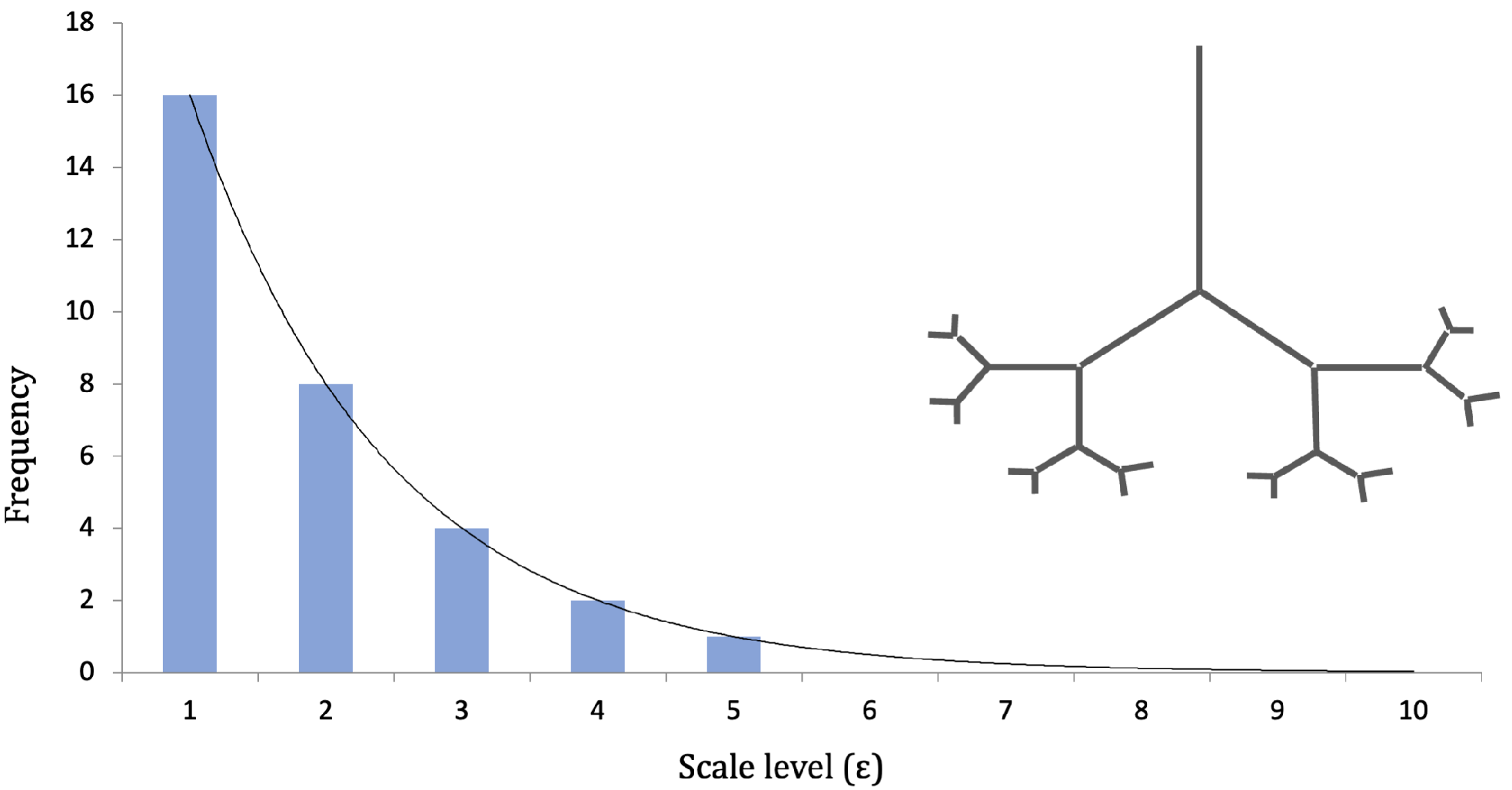
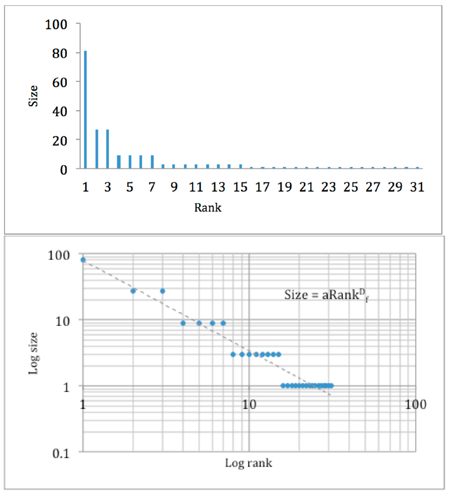
2. What Are Fractals and How Are They Measured?

3. What Fractal Signature Are Found in Urban Fabric?
4. What Real-World Evidence Links Urban Processes and Fractal Dimension?
5. How Does Fractal Dimension Indicate History and Institutional Context?
6. What Normative Evidence Exists about Urban Fractal Patterns?
6.1. Fractal Forms and Open Space
6.2. Fractal Framework Guiding Urban Design
6.3. Fractal Metaphors to Guide the Planning Process
7. What Does the Literature on Fractals and Urban Planning Look Like?
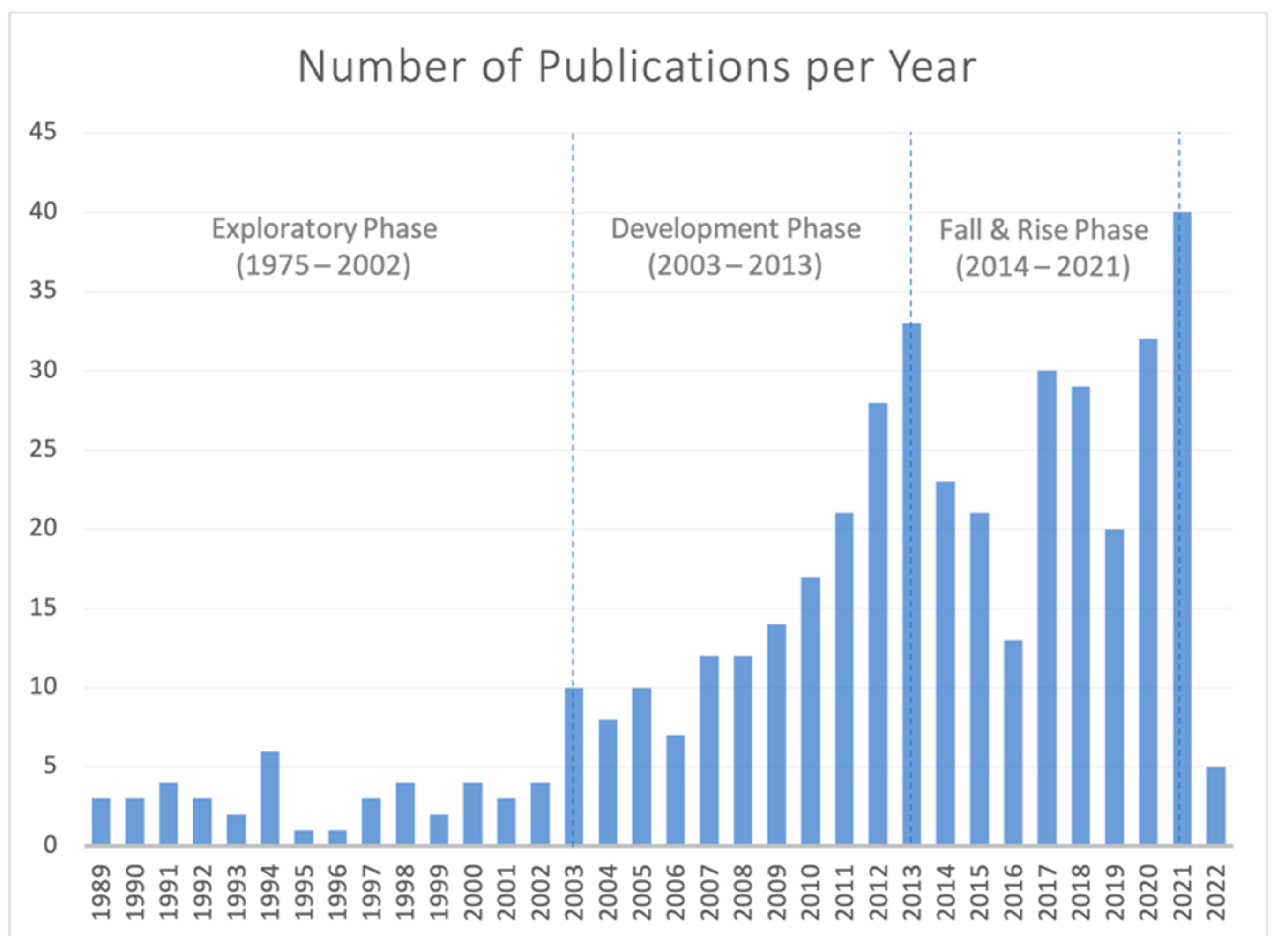
7.1. Publication History
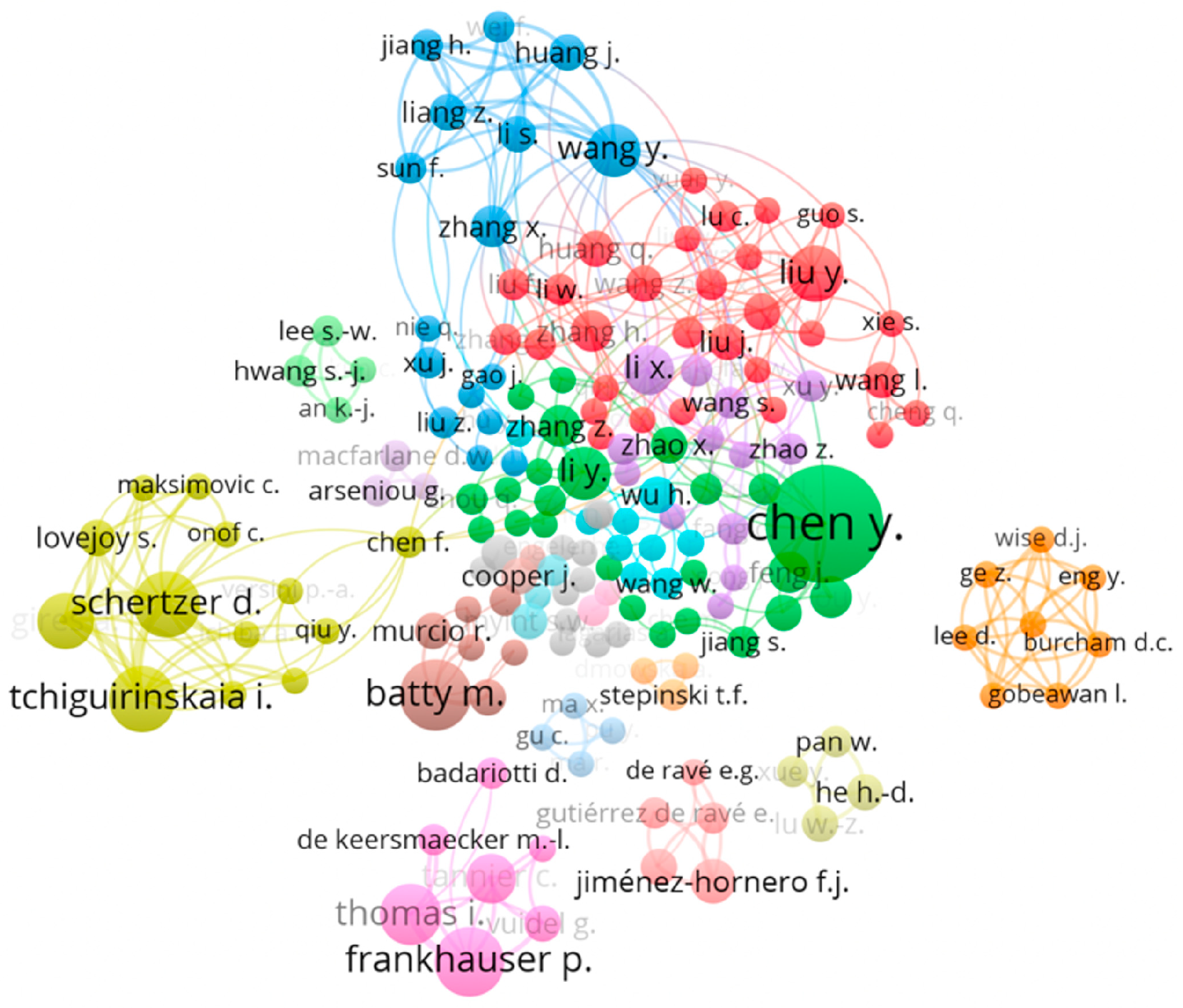
7.2. Topic Analysis
7.3. Journal Representations
7.4. Gaps
8. Discussion and Conclusions
- As an explanatory theory, providing an understanding of urban form. Urban patterns (both built and socioeconomic) display fractal properties of self-similarity and hierarchy. Different fractal signatures may be associated with different urban development processes/developmental stages, and this association can be used to categorize urban landscapes. Fractal-based models that can simulate urban growth/development can be developed to improve understanding of (1) underlying processes generating the patterns observed and (2) examine ‘what if’ scenarios for urban policymaking.
- As a metric for guiding urban planning and evaluating outcomes. When combined with other metrics and an understanding of the urban context, fractal dimension can reflect human well-being outcomes and urban aesthetics, and fractal values between a certain range may be more functional or desirable.
- As a metaphor/framework for developing more effective urban policies; because fractals are self-similar systems that are aligned at multiple scales to achieve a system goal, they can be a useful model or metaphor for urban governance.
Author Contributions
Funding
Data Availability Statement
Acknowledgments
Conflicts of Interest
References
- Rosenzweig, C.; Solokei, W.; Romero-Lankao, P.; Mehrota, S.; Dhakal, S.; Ibraham, S.A. Urban Climate Science; Climate Change and Cities, Second Assessment Report of the Urban Climate Change Research; Cambridge University Press: New York, NY, USA, 2018. [Google Scholar]
- Bettencourt, L.M.A. Introduction to Urban Science: Evidence and Theory of Cities as Complex Systems. Introd. Urban Sci. 2021. [Google Scholar] [CrossRef]
- Meyfroidt, P.; de Bremond, A.; Ryan, C.M.; Archer, E.; Aspinall, R.; Chhabra, A.; Camara, G.; Corbera, E.; De Fries, R.; Díaz, S.; et al. Ten facts about land systems for sustainability. Proc. Natl. Acad. Sci. USA 2022, 119, 7. [Google Scholar] [CrossRef] [PubMed]
- Zellner, M.; Campbell, S.D. Planning for deep-rooted problems: What can we learn from aligning complex systems and wicked problems? Plan. Theory Pract. 2015, 16, 457–478. [Google Scholar] [CrossRef]
- Batty, M.; Xie, Y. Preliminary Evidence for a Theory of the Fractal City. Environ. Plan. A Econ. Space 1996, 28, 1745–1762. [Google Scholar] [CrossRef]
- White, R.; Engelen, G. Cellular Automata and Fractal Urban Form: A Cellular Modelling Approach to the Evolution of Urban Land-Use Patterns. Environ. Plan. A Econ. Space 1993, 25, 1175–1199. [Google Scholar] [CrossRef] [Green Version]
- Batty, M.; Longley, P. The fractal city. Archit. Des. 1997, 129, 74–83. [Google Scholar]
- Chen, Y. A set of formulae on fractal dimension relations and its application to urban form. Chaos Solitons Fractals 2013, 54, 150–158. [Google Scholar] [CrossRef] [Green Version]
- Boeing, G. Measuring the complexity of urban form and design. Urban Des. Int. 2018, 23, 281–292. [Google Scholar] [CrossRef] [Green Version]
- Mandelbrot, B.B. Is nature fractal? Science 1998, 279, 783–786. [Google Scholar] [CrossRef]
- Batty, M.; Longley, P.A. Fractal Cities: A Geometry of Form and Function; Academic Press Inc.: San Diego, CA, USA, 1994; p. 394. [Google Scholar]
- Parker, D.C.; Tolmie, S.; Euerby, A.; Jahanmiri, F.; Mansell, N.; Mansell, D. Canada. In Dancing the Math of Complex Systems: An Introduction to Complexity, Emergence, and Fractals; University of Waterloo Bridges Lecture Series; St. Jermone’s College: Waterloo, ON, Canada, 2015; Available online: https://www.youtube.com/watch?v=bWWJXreuA2w (accessed on 6 February 2022).
- Jin, Y.; Wu, Y.; Li, H.; Zhao, M.; Pan, J. Definition of fractal topography to essential understanding of scale-invariance. Sci. Rep. 2017, 7, 46672. [Google Scholar] [CrossRef] [Green Version]
- Jahanmiri, F. Making sense of the fractal urban form and function: An agent-based modeling approach. In Making Sense of the Fractal Urban Form and Function: An Agent-Based Modeling Approach; University of Waterloo: Waterloo, ON, Canada, 2015. [Google Scholar]
- Stumpf, M.P.H.; Porter, M.A. Critical Truths About Power Laws. Science 2012, 335, 665–666. [Google Scholar] [CrossRef] [PubMed]
- Chen, Y.; Wang, J. Multifractal characterization of urban form and growth: The case of Beijing. Environ. Plan. B Plan. Des. 2013, 40, 884–904. [Google Scholar] [CrossRef]
- Soille, P.; Rivest, J.-F. On the Validity of Fractal Dimension Measurements in Image Analysis. J. Vis. Commun. Image Represent. 1996, 7, 217–229. [Google Scholar] [CrossRef]
- Thomas, I.; Frankhauser, P.; Biernacki, C. The morphology of built-up landscapes in Wallonia (Belgium): A classification using fractal indices. Landsc. Urban Plan. 2008, 84, 99–115. [Google Scholar] [CrossRef]
- Thomas, I.; Frankhauser, P.; Frenay, B.; Verleysen, M. Clustering Patterns of Urban Built-up Areas with Curves of Fractal Scaling Behaviour. Environ. Plan. B Plan. Des. 2010, 37, 942–954. [Google Scholar] [CrossRef]
- Herold, M.; Scepan, J.; Clarke, K.C. The Use of Remote Sensing and Landscape Metrics to Describe Structures and Changes in Urban Land Uses. Environ. Plan. A Econ. Space 2002, 34, 1443–1458. [Google Scholar] [CrossRef] [Green Version]
- Lemoy, R.; Caruso, G. Evidence for the homothetic scaling of urban forms. Environ. Plan. B Urban Anal. City Sci. 2018, 47, 870–888. [Google Scholar] [CrossRef]
- Li, Y.; Rybski, D.; Kropp, J.P. Singularity cities. Environ. Plan. B Urban Anal. City Sci. 2019, 48, 43–59. [Google Scholar] [CrossRef]
- Chen, Y. Fractal analytical approach of urban form based on spatial correlation function. Chaos Solitons Fractals 2013, 49, 47–60. [Google Scholar] [CrossRef] [Green Version]
- Chen, Y. Normalizing and classifying shape indexes of cities by ideas from fractals. Chaos Solitons Fractals 2021, 154, 111653. [Google Scholar] [CrossRef]
- Batty, M. Cellular Automata and Urban Form: A Primer. J. Am. Plan. Assoc. 1997, 63, 266–274. [Google Scholar] [CrossRef]
- Fialkowski, M.; Bitner, A. Universal rules for fragmentation of land by humans. Landsc. Ecol. 2008, 23, 1013–1022. [Google Scholar] [CrossRef]
- Batty, M.; Carvalho, R.; Hudson-Smith, A.; Milton, R.; Smith, D.; Steadman, P. Scaling and allometry in the building geometries of Greater London. Eur. Phys. J. B 2008, 63, 303–314. [Google Scholar] [CrossRef]
- Batty, M. Building a science of cities. Cities 2012, 29, S9–S16. [Google Scholar] [CrossRef] [Green Version]
- Ma, Q.; Wu, J.; He, C.; Hu, G. Spatial scaling of urban impervious surfaces across evolving landscapes: From cities to urban regions. Landsc. Urban Plan. 2018, 175, 50–61. [Google Scholar] [CrossRef]
- Wang, H.; Luo, S.; Luo, T. Fractal characteristics of urban surface transit and road networks: Case study of Strasbourg, France. Adv. Mech. Eng. 2017, 9, 1687814017692289. [Google Scholar] [CrossRef] [Green Version]
- Umemoto, D.; Ito, N. Power-law distribution found in city-scale traffic flow simulation. J. Phys. Conf. Ser. 2021, 2122, 012006. [Google Scholar] [CrossRef]
- Figure 4, Schwarzplan.eu © OpenStreetMap Contributors. Available online: https://schwarzplan.eu/lizenzbestimmungen-copyright/ (accessed on 3 February 2022).
- Greig, J. Sierpinski Carpet. Available online: https://commons.wikimedia.org/wiki/File:Sierpinski_carpet.png (accessed on 3 February 2022).
- Martínez, F. Cities’ power laws: The stochastic scaling factor. Environ. Plan. B Plan. Des. 2015, 43, 257–275. [Google Scholar] [CrossRef]
- Clauset, A.; Shalizi, C.R.; Newman, M.E.J. Power-Law Distributions in Empirical Data. SIAM Rev. 2009, 51, 661–703. [Google Scholar] [CrossRef] [Green Version]
- Weng, Y.-C.; Chang, N.-B.; Lee, T. Nonlinear time series analysis of ground-level ozone dynamics in Southern Taiwan. J. Environ. Manag. 2008, 87, 405–414. [Google Scholar] [CrossRef]
- Packard, N.H.; Crutchfield, J.P.; Farmer, J.D.; Shaw, R.S. Geometry from a Time Series. Phys. Rev. Lett. 1980, 45, 712–716. [Google Scholar] [CrossRef]
- Kim, J.S.; Goh, K.-I.; Salvi, G.; Oh, E.; Kahng, B.; Kim, D. Fractality in complex networks: Critical and supercritical skeletons. Phys. Rev. E 2007, 75, 016110. [Google Scholar] [CrossRef] [PubMed] [Green Version]
- Padua, R.N.; Borres, M.S. University of San Jose-Recoletos From Fractal Geometry to Statistical Fractal. Recoletos Multidiscip. Res. J. 2013, 1, 73–80. [Google Scholar] [CrossRef]
- Akkerman, A. Fuzzy targeting of population niches in urban planning and the fractal dimension of demographic change. Urban Stud. 1992, 29, 1093–1113. [Google Scholar] [CrossRef]
- Batty, M.; Longley, P.A. Urban shapes as fractals (Cardiff). Area 1987, 19, 215–221. [Google Scholar] [CrossRef]
- Zhou, W.-X.; Sornette, D.; Hill, R.; Dunbar, R.I.M. Discrete hierarchical organization of social group sizes. Proc. R. Soc. B Boil. Sci. 2005, 272, 439–444. [Google Scholar] [CrossRef] [Green Version]
- Fuchs, B.; Sornette, D.; Thurner, S. Fractal multi-level organisation of human groups in a virtual world. Sci. Rep. 2014, 4, 6526. [Google Scholar] [CrossRef] [Green Version]
- Brelsford, C.; Lobo, J.; Hand, J.; Bettencourt, L.M.A. Heterogeneity and scale of sustainable development in cities. Proc. Natl. Acad. Sci. USA 2017, 114, 8963–8968. [Google Scholar] [CrossRef] [Green Version]
- Axtell, R.L. Zipf Distribution of U.S. Firm Sizes. Science 2001, 293, 1818–1820. [Google Scholar] [CrossRef] [Green Version]
- Aoyama, H.; Yoshikawa, H.; Iyetomi, H.; Fujiwara, Y. Labour productivity superstatistics. Prog. Theor. Phys. Suppl. 2009, 179, 80–92. [Google Scholar] [CrossRef] [Green Version]
- Hu, S.; Cheng, Q.; Wang, L.; Xu, D. Modeling land price distribution using multifractal IDW interpolation and fractal filtering method. Landsc. Urban Plan. 2013, 110, 25–35. [Google Scholar] [CrossRef]
- Muchnik, L.; Pei, S.; Parra, L.C.; Reis, S.D.S.; Andrade, J.S., Jr.; Havlin, S.; Makse, H.A. Origins of power-law degree distribution in the heterogeneity of human activity in social networks. Sci. Rep. 2013, 3, 1783. [Google Scholar] [CrossRef] [Green Version]
- Beare, B.K.; Toda, A.A. On the emergence of a power law in the distribution of COVID-19 cases. Phys. D Nonlinear Phenom. 2020, 412, 132649. [Google Scholar] [CrossRef] [PubMed]
- Sarkar, S.; Phibbs, P.; Simpson, R.; Wasnik, S. The scaling of income distribution in Australia: Possible relationships between urban allometry, city size, and economic inequality. Environ. Plan. B Urban Anal. City Sci. 2016, 45, 603–622. [Google Scholar] [CrossRef] [Green Version]
- Gunz, H.P.; Lichten, B.M.B.; Long, R.G. Self-Organization in Career Systems: A View from Complexity Science. Management 2002, 5, 63–88. [Google Scholar] [CrossRef] [Green Version]
- Batty, M. The Size, Scale, and Shape of Cities. Science 2008, 319, 769–771. [Google Scholar] [CrossRef] [PubMed] [Green Version]
- Samaniego, H.; Moses, M.E. Cities as organisms: Allometric scaling of urban road networks. JSTOR 2008, 1, 21–39. Available online: https://www.jstor.org/stable/26201607 (accessed on 6 February 2022). [CrossRef] [Green Version]
- Shpuza, E. Allometry in the Syntax of Street Networks: Evolution of Adriatic and Ionian Coastal Cities 1800–2010. Environ. Plan. B Plan. Des. 2014, 41, 450–471. [Google Scholar] [CrossRef]
- Yu, X.; Zhao, Z. Fractal Characteristic Evolution of Coastal Settlement Land Use: A Case of Xiamen, China. Land 2021, 11, 50. [Google Scholar] [CrossRef]
- Andersson, C.; Rasmussen, S.; White, R. Urban Settlement Transitions. Environ. Plan. B Plan. Des. 2002, 29, 841–865. [Google Scholar] [CrossRef]
- Batty, M.; Longley, P.; Fotheringham, S. Urban Growth and Form: Scaling, Fractal Geometry, and Diffusion-Limited Aggregation. Environ. Plan. A Econ. Space 1989, 21, 1447–1472. [Google Scholar] [CrossRef]
- Sander, L.M. Diffusion-limited aggregation: A kinetic critical phenomenon? Contemp. Phys. 2000, 41, 203–218. [Google Scholar] [CrossRef]
- Yeh, A.G.-O.; Li, X. A Constrained CA Model for the Simulation and Planning of Sustainable Urban Forms by Using GIS. Environ. Plan. B Plan. Des. 2001, 28, 733–753. [Google Scholar] [CrossRef] [Green Version]
- Liu, C.L.; Duan, D.-Z. Spatial Growth of Urban-Rural Road Network in Wuhan Metropolitan Area Based on Fractal Theory. J. Transp. Syst. Eng. Inf. Technol. 2013, 13, 185–193. [Google Scholar]
- Makse, H.A.; Havlin, S.; Stanley, H.E. Modelling urban growth patterns. Nature 1995, 377, 608–612. [Google Scholar] [CrossRef]
- Geoff Kimm, S.J.K.; Alhadidi, S. Generative Architecture in Dla Space. In Proceedings of the 20th International Conference on Computer-Aided Architectural Design Research in Asia (CAADRIA 2015), Emerging Experiences in The Past, Present and Future of Digital Architecture, Daegu, Korea, 20–22 May 2015; pp. 189–198. [Google Scholar]
- van Vliet, J.; Hurkens, J.; White, R.; van Delden, H. An Activity-Based Cellular Automaton Model to Simulate Land-Use Dynamics. Environ. Plan. B Plan. Des. 2012, 39, 198–212. [Google Scholar] [CrossRef]
- Batty, M. Cities as fractals: Simulating growth and form. In Fractals and Chaos; Springer: New York, NY, USA, 1991; pp. 43–69. [Google Scholar]
- Clarke, K.C.; Gaydos, L.J. Loose-coupling. A cellular automaton model and GIS: Long-term urban growth prediction for San Francisco and Washington/Baltimore. Int. J. Geogr. Inf. Sci. 1998, 1, 699–714. [Google Scholar] [CrossRef] [Green Version]
- Portugali, J.; Meyer, H.; Stolk, E.; Tan, E. (Eds.) Complexity Theories of Cities Have Come of Age: An Overview with Implications to urban Planning and Design; Springer: Berlin/Heidelberg, Germany; Dordrecht, The Netherlands; London, UK; New York, NY, USA, 2012. [Google Scholar]
- Frankhauser, P.; Sadler, R. Fractal analysis of agglomerations. In Natural Structures: Principles, Strategies, and Models in Architecture and Nature; University of Stuttgart: Stuttgart, Germany, 1991; pp. 57–65. [Google Scholar]
- Lin, J.; Huang, B.; Chen, M.; Huang, Z. Modeling urban vertical growth using cellular automata—Guangzhou as a case study. Appl. Geogr. 2014, 53, 172–186. [Google Scholar] [CrossRef]
- Caruso, G.; Rounsevell, M.; Cojocaru, G. Exploring a spatio-dynamic neighbourhood-based model of residential behaviour in the Brussels periurban area. Int. J. Geogr. Inf. Sci. 2005, 19, 103–123. [Google Scholar] [CrossRef]
- Barredo, J.I.; Kasanko, M.; McCormick, N.; Lavalle, C. Modelling dynamic spatial processes: Simulation of urban future scenarios through cellular automata. Landsc. Urban Plan. 2003, 64, 145–160. [Google Scholar] [CrossRef]
- van Vliet, J.; White, R.; Dragicevic, S. Modeling urban growth using a variable grid cellular automaton. Comput. Environ. Urban Syst. 2009, 33, 35–43. [Google Scholar] [CrossRef]
- Parker, D.C.; Meretsky, V. Measuring pattern outcomes in an agent-based model of edge-effect externalities using spatial metrics. Agric. Ecosyst. Environ. 2004, 101, 233–250. [Google Scholar] [CrossRef]
- Langton, C.G. Computation at the edge of chaos: Phase transitions and emergent computation. Phys. D Nonlinear Phenom. 1990, 1, 12–37. [Google Scholar] [CrossRef] [Green Version]
- Crooks, A.; Heppenstall, A.; Malleson, N.; Manley, E. Agent-based modeling and the city: A gallery of applications. In Urban Informatics; Springer: Singapore, 2021; pp. 885–910. [Google Scholar]
- Barabási, A.-L.; Albert, R. Emergence of scaling in random networks. Science 1999, 286, 509–512. Available online: https://arxiv.org/pdf/cond-mat/9910332.pdf%3Forigin%3Dpublication_detail (accessed on 30 October 2017). [CrossRef] [Green Version]
- Axtell, R. The Emergence of Firms in a Population of Agents: Local Increasing Returns, Unstable Nash Equilibria, And Power Law Size Distributions; Working paper no. 3; Brookings Institution: Washington, DC, USA, 1999; Available online: https://www.brookings.edu/wp-content/uploads/2016/06/firms.pdf (accessed on 30 October 2017).
- Shi, W.; Goodchild, M.F.; Batty, M.; Kwan, M.-P.; Zhang, A. Urban Informatics; Springer: Singapore, 2021. [Google Scholar] [CrossRef]
- Batty, M.; Milton, R. A new framework for very large-scale urban modelling. Urban Stud. 2021, 58, 3071–3094. [Google Scholar] [CrossRef]
- Batty, M.; Kim, K.S. Form Follows Function: Reformulating Urban Population Density Functions. Urban Stud. 1992, 29, 1043–1069. [Google Scholar] [CrossRef]
- Longley, P.A.; Mesev, V. Measurement of density gradients and space-filling in urban systems. Pap. Reg. Sci. 2002, 81, 1–28. [Google Scholar] [CrossRef]
- Thomas, I.; Frankhauser, P.; De Keersmaecker, M.-L. Fractal dimension versus density of built-up surfaces in the periphery of Brussels. Pap. Reg. Sci. 2007, 86, 287–308. [Google Scholar] [CrossRef]
- Filion, P.; McSpurren, K.; Appleby, B. Wasted Density? The Impact of Toronto’s Residential-Density-Distribution Policies on Public-Transit Use and Walking. Environ. Plan. A Econ. Space 2006, 38, 1367–1392. [Google Scholar] [CrossRef] [Green Version]
- Chen, Y. A new model of urban population density indicating latent fractal structure. Int. J. Urban Sustain. Dev. 2010, 1, 89–110. [Google Scholar] [CrossRef] [Green Version]
- Filion, P.; Bunting, T.; Pavlic, D.; Langlois, P. Intensification and Sprawl: Residential Density Trajectories in Canada’s Largest Metropolitan Regions. Urban Geogr. 2010, 31, 541–569. [Google Scholar] [CrossRef]
- Chen, Y.; Feng, J. Fractal-based exponential distribution of urban density and self-affine fractal forms of cities. Chaos Solitons Fractals 2012, 45, 1404–1416. [Google Scholar] [CrossRef] [Green Version]
- Csikós, N.; Szilassi, P. Modelling the Impacts of Habitat Changes on the Population Density of Eurasian Skylark (Alauda arvensis) Based on Its Landscape Preferences. Land 2021, 10, 306. [Google Scholar] [CrossRef]
- Newton, P.; Glackin, S.; Witheridge, J.; Garner, L. Beyond small lot subdivision: Towards municipality-initiated and resident-supported precinct scale medium density residential infill regeneration in greyfield suburbs. Beyond Small Lot Subdivision: Towards Municipality-initiated and Resident-supported Precinct-Scale Medium-Density Residential Infill Regeneration in Greyfield Suburbs. Urban Policy Res. 2020, 38, 338–356. [Google Scholar] [CrossRef]
- Marat-Mendes, T.; de Sampayo, M.T.; Rodrigues, D. Measuring Lisbon patterns: Baixa from 1650 to 2010. Nexus Netw. J. 2011, 13, 351–372. [Google Scholar] [CrossRef] [Green Version]
- Tannier, C.; Pumain, D. Fractals in urban geography: A theoretical outline and an empirical example. Cybergeo 2005, 2005. [Google Scholar] [CrossRef]
- Fang, G.; Zhang, Y.; Yang, J. Evolution of Urban Landscape Pattern in Suzhou City during 1987–2009. Appl. Mech. Mater. 2012, 178–181, 332–336. [Google Scholar] [CrossRef]
- Feng, J.; Chen, Y. Spatiotemporal Evolution of Urban Form and Land-Use Structure in Hangzhou, China: Evidence from Fractals. Environ. Plan. B Plan. Des. 2010, 37, 838–856. [Google Scholar] [CrossRef]
- Encarnação, S.; Gaudiano, M.; Santos, F.C.; Tenedório, J.A.; Pacheco, J.M. Fractal cartography of urban areas. Sci. Rep. 2012, 2, 527. [Google Scholar] [CrossRef] [Green Version]
- Chen, Y.; Feng, J. A Hierarchical Allometric Scaling Analysis of Chinese Cities: 1991–2014. Discret. Dyn. Nat. Soc. 2017, 2017, 5243287. [Google Scholar] [CrossRef]
- Chen, Y.; Zhou, Y. The Rank-Size Rule and Fractal Hierarchies of Cities: Mathematical Models and Empirical Analyses. Environ. Plan. B Plan. Des. 2003, 30, 799–818. [Google Scholar] [CrossRef]
- McLeod, S.; Scheurer, J.; Curtis, C. Urban Public Transport. J. Plan. Lit. 2017, 32, 223–239. [Google Scholar] [CrossRef]
- Handy, S. Smart Growth and the Transportation-Land Use Connection: What Does the Research Tell Us? Int. Reg. Sci. Rev. 2005, 28, 146–167. [Google Scholar] [CrossRef]
- Benguigui, L. A Fractal Analysis of the Public Transportation System of Paris. Environ. Plan. A Econ. Space 1995, 27, 1147–1161. [Google Scholar] [CrossRef]
- Lu, Y.; Tang, J. Fractal Dimension of a Transportation Network and its Relationship with Urban Growth: A Study of the Dallas-Fort Worth Area. Environ. Plan. B Plan. Des. 2016, 31, 895–911. [Google Scholar] [CrossRef] [Green Version]
- Sahitya, K.S.; Prasad, C. Fractal modelling of an urban road network using Geographical Information Systems (GIS). World Rev. Intermodal Transp. Res. 2020, 9, 376–392. [Google Scholar] [CrossRef]
- Rydin, Y.; Bleahu, A.; Davies, M.; Dávila, J.D.; Friel, S.; De Grandis, G.; Groce, N.; Hallal, P.C.; Hamilton, I.; Howden-Chapman, P.; et al. Shaping cities for health: Complexity and the planning of urban environments in the 21st century. Lancet 2012, 379, 2079–2108. [Google Scholar] [CrossRef] [Green Version]
- Wang, H.; Su, X.; Wang, C.; Dong, R. Fractal analysis of urban form as a tool for improving environmental quality. Int. J. Sustain. Dev. World Ecol. 2011, 18, 548–552. [Google Scholar] [CrossRef]
- Thomas, I.; Tannier, C.; Frankhauser, P. Is there a link between fractal dimension and residential environment at a regional level? Cybergeo 2008, 413, 24. [Google Scholar] [CrossRef]
- Hepcan, C.C. Quantifying landscape pattern and connectivity in a Mediterranean coastal settlement: The case of the Urla district, Turkey. Environ. Monit. Assess. 2012, 185, 143–155. [Google Scholar] [CrossRef]
- Konijnendijk, C. The 3-30-300 Rule for Urban Forestry and Greener Cities. Biophilic Cities J. 2021. Available online: https://static1.squarespace.com/static/5bbd32d6e66669016a6af7e2/t/6101ce2b17dc51553827d644/1627508274716/330300+Rule+Preprint_7-29-21.pdf (accessed on 2 February 2022).
- Spehar, B.; Taylor, R.P. Fractals in art and nature: Why do we like them? Hum. Vis. Electron. Imaging XVIII 2013, 8651, 865118. [Google Scholar] [CrossRef]
- Nagy, D.; Villaggi, L.; Benjamin, D. Generative Urban Design: Integrating Financial and Energy Goals for Automated Neighborhood Layout. Proc. Symp. Archit. Urban Des. 2018, 25, 1–8. [Google Scholar] [CrossRef]
- Milne, B.T. The utility of fractal geometry in landscape design. Landsc. Urban Plan. 1991, 21, 81–90. [Google Scholar] [CrossRef]
- Jevrić, M.; Knežević, M.; Kalezić, J.; Kopitović-Vuković, N.; Ćipranić, I. Application of fractal geometry in urban pattern design. Teh. Vjesn. Tech. Gaz. 2014, 21, 873–879. [Google Scholar]
- Wang, X.; Song, Y.; Tang, P. Generative urban design using shape grammar and block morphological analysis. Front. Arch. Res. 2020, 9, 914–924. [Google Scholar] [CrossRef]
- Wilson, L.; Danforth, J.; Davila, C.C.; Harvey, D. How to Generate a Thousand Master Plans: A Framework for Computational Urban Design. In Proceedings of the 10th Symposium on Simulation for Architecture and Urban Design SimAUD, Atlanta, GA, USA, 7–9 April 2019. [Google Scholar]
- Liang, J.; Hu, Y.; Sun, H. The Design Evaluation of the Green Space Layout of Urban Squares Based on Fractal Theory. Nexus Netw. J. 2012, 15, 33–49. [Google Scholar] [CrossRef] [Green Version]
- Ahern, J. Urban landscape sustainability and resilience: The promise and challenges of integrating ecology with urban planning and design. Landsc. Ecol. 2012, 28, 1203–1212. [Google Scholar] [CrossRef]
- Yanyan, W.; Jiejun, H.; Yunjun, Z.; Yanbin, Y.; Fawang, Y. Analysis of Yiwu Urban Expansion and Spatial Morphologic Changes Based on Fractal and RS. In Proceedings of the 2008 International Symposium on Computational Intelligence and Design, Wuhan, China, 17–18 October 2008; Volume 2, pp. 203–206. [Google Scholar] [CrossRef]
- Taylor, R.P.; Spehar, B.; Van Donkelaar, P.; Hagerhall, C.M. Perceptual and Physiological Responses to Jackson Pollock’s Fractals. Front. Hum. Neurosci. 2011, 5, 60. [Google Scholar] [CrossRef] [Green Version]
- Cooper, J.; Watkinson, D.; Oskrochi, R. Fractal analysis and perception of visual quality in everyday street vistas. Environ. Plan. B 2010, 37, 808–822. Available online: https://www.researchgate.net/profile/Jon_Cooper2/publication/227472693_Fractal_analysis_and_perception_of_visual_quality_in_everyday_street_vistas/links/00b7d529884cc7c1a3000000.pdf (accessed on 30 October 2017). [CrossRef]
- Cooper, J.; Su, M.-L.; Oskrochi, R. The Influence of Fractal Dimension and Vegetation on the Perceptions of Streetscape Quality in Taipei: With Comparative Comments Made in Relation to Two British Case Studies. Environ. Plan. B Plan. Des. 2013, 40, 43–62. [Google Scholar] [CrossRef]
- Feng, L.; Li, H. Spatial Pattern Analysis of Urban Sprawl: Case Study of Jiangning, Nanjing, China. J. Urban Plan. Dev. 2012, 138, 263–269. [Google Scholar] [CrossRef]
- Terzi, F.; Kaya, H. Dynamic spatial analysis of urban sprawl through fractal geometry: The case of Istanbul. Environ. Plan. B Plan. Des. 2011, 38, 175–190. [Google Scholar] [CrossRef]
- bin Ibrahim, A.L.; Sarvestani, M.S. Urban sprawl pattern recognition using remote sensing and GIS-Case study Shiraz city, Iran. In Proceedings of the 2009 Joint Urban Remote Sensing Event, Shanghai, China, 20–22 May 2009. [Google Scholar] [CrossRef]
- Huang, S.-L.; Wang, S.-H.; Budd, W.W. Sprawl in Taipei’s peri-urban zone: Responses to spatial planning and implications for adapting global environmental change. Landsc. Urban Plan. 2009, 90, 20–32. [Google Scholar] [CrossRef]
- Tannier, C.; Vuidel, G.; Houot, H.; Frankhauser, P. Spatial accessibility to amenities in fractal and nonfractal urban patterns. Environ. Plan. B Plan. Des. 2012, 39, 801–819. [Google Scholar] [CrossRef]
- Chettiparamb, A. Metaphors in Complexity Theory and Planning. Plan. Theory 2006, 5, 71–91. [Google Scholar] [CrossRef]
- Kauffman, S.A. Whispers from Carnot-The Origins of Order and Principles of Adaptation in Complex Nonequilibrium Systems. Complex. Metaphor. Models Real. 1994, 19, 83–160. [Google Scholar]
- Crowley, D.; Marat-Mendes, T.; Falanga, R.; Henfrey, T.; Penha-Lopes, G. Towards a necessary regenerative urban planning: Insights from community-led initiatives for ecocity transformation. Cidades. Comunidades E Territ. 2021, 83–104. [Google Scholar] [CrossRef]
- Chettiparamb, A. Complexity theory and planning: Examining ‘fractals’ for organising policy domains in planning practice. Plan. Theory 2014, 13, 5–25. [Google Scholar] [CrossRef]
- Wohl, S. From form to process: Re-conceptualizing Lynch in light of complexity theory. Urban Des. Int. 2017, 22, 303–317. [Google Scholar] [CrossRef]
- Mady, C.; Chettiparamb, A. Planning in the face of ‘deep divisions’: A view from Beirut, Lebanon. Plan. Theory 2017, 16, 296–317. [Google Scholar] [CrossRef]
- Chettiparamb, A. Fractal spaces for planning and governance. Town Plan. Rev. 2005, 76, 317–340. [Google Scholar] [CrossRef]
- Elsevier, B.V. SciVal®. 2022. Available online: www.scival.com (accessed on 3 February 2022).
- Van Eck, N.J.; Waltman, L. Visualizing bibliometric networks. In Measuring Scholarly Impact; Springer: Cham, Switzerland, 2014; pp. 285–320. [Google Scholar] [CrossRef]
- Liu, J.S.; Chen, Y.G. A study on fractal dimensions of spatial structure of transport networks and the methods of their determination. Acta Geogr. Sin. 1999, 54, 471–478. [Google Scholar]
- Keersmaecker, M.L.; Frankhauser, P.; Thomas, I. Using fractal dimensions for The example of Brussels. Geogr. Anal. 2003, 35, 310–328. [Google Scholar] [CrossRef]
- Tannier, C.; Foltête, J.-C.; Girardet, X. Assessing the capacity of different urban forms to preserve the connectivity of ecological habitats. Landsc. Urban Plan. 2012, 105, 128–139. [Google Scholar] [CrossRef]
- Zhao, C.; Li, Y.; Weng, M. A Fractal Approach to Urban Boundary Delineation Based on Raster Land Use Maps: A Case of Shanghai, China. Land 2021, 10, 941. [Google Scholar] [CrossRef]
- Cremades, R.; Sommer, P.S. Computing climate-smart urban land use with the Integrated Urban Complexity model (IUCm 1.0). Geosci. Model Dev. 2019, 12, 525–539. [Google Scholar] [CrossRef] [Green Version]
- Lu, Z.; Zhang, H.; Southworth, F.; Crittenden, J. Fractal dimensions of metropolitan area road networks and the impacts on the urban built environment. Ecol. Indic. 2016, 70, 285–296. [Google Scholar] [CrossRef] [Green Version]
- Elsevier, B.V. Scopus®. 2022. Available online: www.scopus.com (accessed on 3 February 2022).
- Elsevier, SciVal, Research Analytics Services. 2022. Available online: https://www.elsevier.com/solutions/scival (accessed on 3 February 2022).
- Stevens, M.R.; Park, K.; Tian, G.; Kim, K.; Ewing, R. Why Do Some Articles in Planning Journals Get Cited More than Others? J. Plan. Educ. Res. 2019, 1–22. [Google Scholar] [CrossRef]
- Alexander, C. Notes on the Synthesis of Form; Harvard University Press: Cambridge, MA, USA, 1964. [Google Scholar]
- Jacobs, J. The Death and Life of Great American Cities; Vintage Books: New York, NY, USA, 1961. [Google Scholar]
- Khan, F.; Pinter, L. Scaling indicator and planning plane: An indicator and a visual tool for exploring the relationship between urban form, energy efficiency and carbon emissions. Ecol. Indic. 2016, 67, 183–192. [Google Scholar] [CrossRef] [Green Version]


| Power-Law Phenomena | Source | Power-Law Phenomena | Source |
|---|---|---|---|
| In Built Form | In Socio-Economic Profiles | ||
| Radial land use density and clusters | [6] | Hierarchy of social group size | [42] |
| Population density (radial) | [21] | Social group size | [43] |
| Building geometries for each land use | [27] | Social networks | [48] |
| Traffic flow distribution (city-scale) | [33] | Covid-19 pandemic growth pattern | [49] |
| Impervious land | [29] | Income distribution | [50] |
| Parcel size by area | [28] | Job vacancies | [51] |
| Building footprint area | [52,53] | Personal income | [44] |
| Length of road network | [53] | Firm size (by revenue) | [45] |
| Allometry of street network | [54] | Firm size by number of employees | [46] |
| Urban boundary | [7] | Land price | [47] |
| Journal Title | Count | Journal Title | Count |
|---|---|---|---|
| Physica A: Statistical Mechanics and its Applications | 18 | Chinese Geographical Science | 6 |
| Chaos, Solitons and Fractals | 18 | Environmental Monitoring and Assessment | 6 |
| Dili Xuebao/Acta Geographica Sinica | 12 | Photogrammetric Engineering and Remote Sensing | 6 |
| Landscape and Urban Planning 1 | 11 | Fractals | 6 |
| Environment and Planning B: Planning and Design 1 | 11 | Environment and Planning A 1 | 5 |
| Remote Sensing | 10 | Nongye Gongcheng Xuebao/Transactions of the Chinese Society of Agricultural Engineering | 5 |
| Computers, Environment and Urban Systems 1 | 9 | Cities 1 | 5 |
| Science of the Total Environment | 7 | Nexus Network Journal | 4 |
| Sustainability (Switzerland) | 7 | Chinese Journal of Ecology | 4 |
| Ecological Indicators | 6 | Hydrology and Earth System Sciences | 4 |
| Fractals in Urban Planning | Urban Models in Planning | |||||
|---|---|---|---|---|---|---|
| Publication Year | Planning Journals | Any Journal | Planning Journals’ Share | Planning Journals | Any Journal | Planning Journals’ Share |
| <2022 | 68 | 428 | 16% | 6971 | 52121 | 13% |
| <2012 | 33 | 182 | 18% | 2637 | 21461 | 12% |
| <2002 | 12 | 43 | 28% | 1102 | 6371 | 17% |
Publisher’s Note: MDPI stays neutral with regard to jurisdictional claims in published maps and institutional affiliations. |
© 2022 by the authors. Licensee MDPI, Basel, Switzerland. This article is an open access article distributed under the terms and conditions of the Creative Commons Attribution (CC BY) license (https://creativecommons.org/licenses/by/4.0/).
Share and Cite
Jahanmiri, F.; Parker, D.C. An Overview of Fractal Geometry Applied to Urban Planning. Land 2022, 11, 475. https://doi.org/10.3390/land11040475
Jahanmiri F, Parker DC. An Overview of Fractal Geometry Applied to Urban Planning. Land. 2022; 11(4):475. https://doi.org/10.3390/land11040475
Chicago/Turabian StyleJahanmiri, Fatemeh, and Dawn Cassandra Parker. 2022. "An Overview of Fractal Geometry Applied to Urban Planning" Land 11, no. 4: 475. https://doi.org/10.3390/land11040475
APA StyleJahanmiri, F., & Parker, D. C. (2022). An Overview of Fractal Geometry Applied to Urban Planning. Land, 11(4), 475. https://doi.org/10.3390/land11040475