


Determining the Extent of Soil Degradation Processes Using Trend Analyses at a Regional Multispectral Scale

 ,
, 
 ,
,  ,
,  and
and 
Abstract
:1. Introduction
2. Materials and Methods
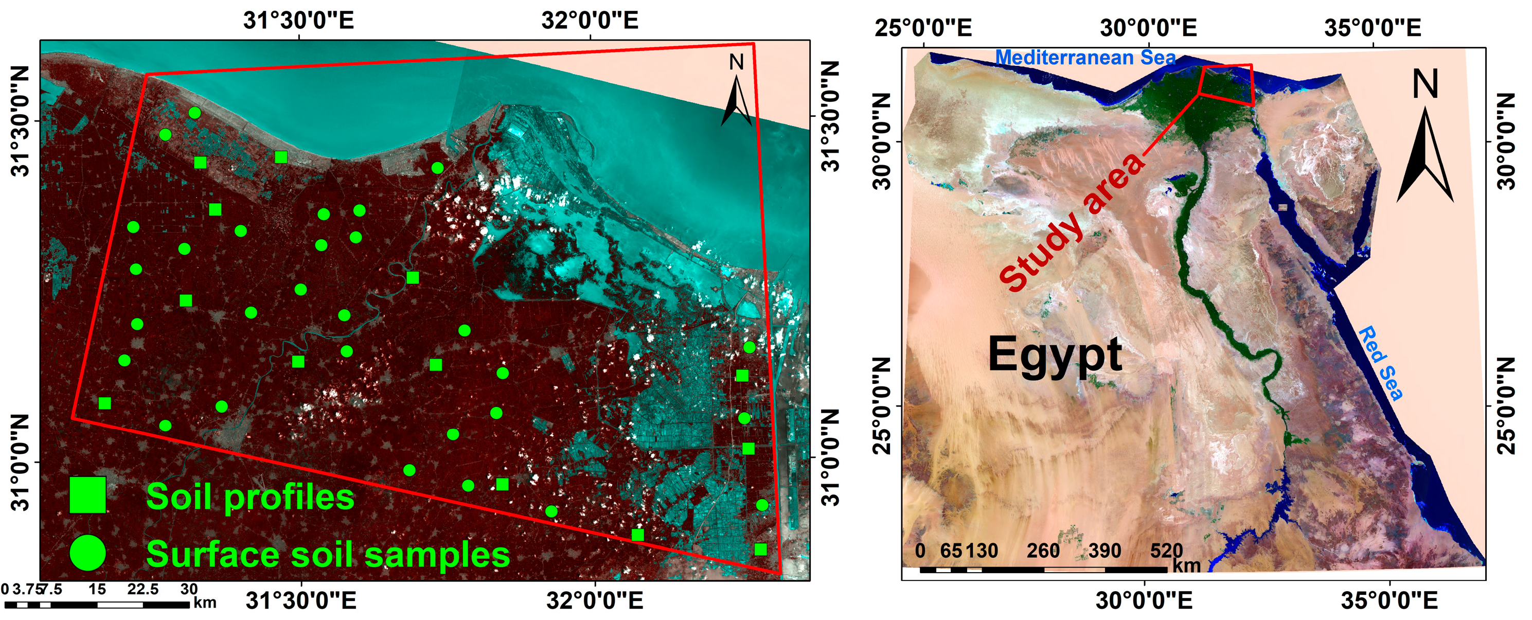
2.1. Study Area
2.2. Field Work and Laboratory Analysis
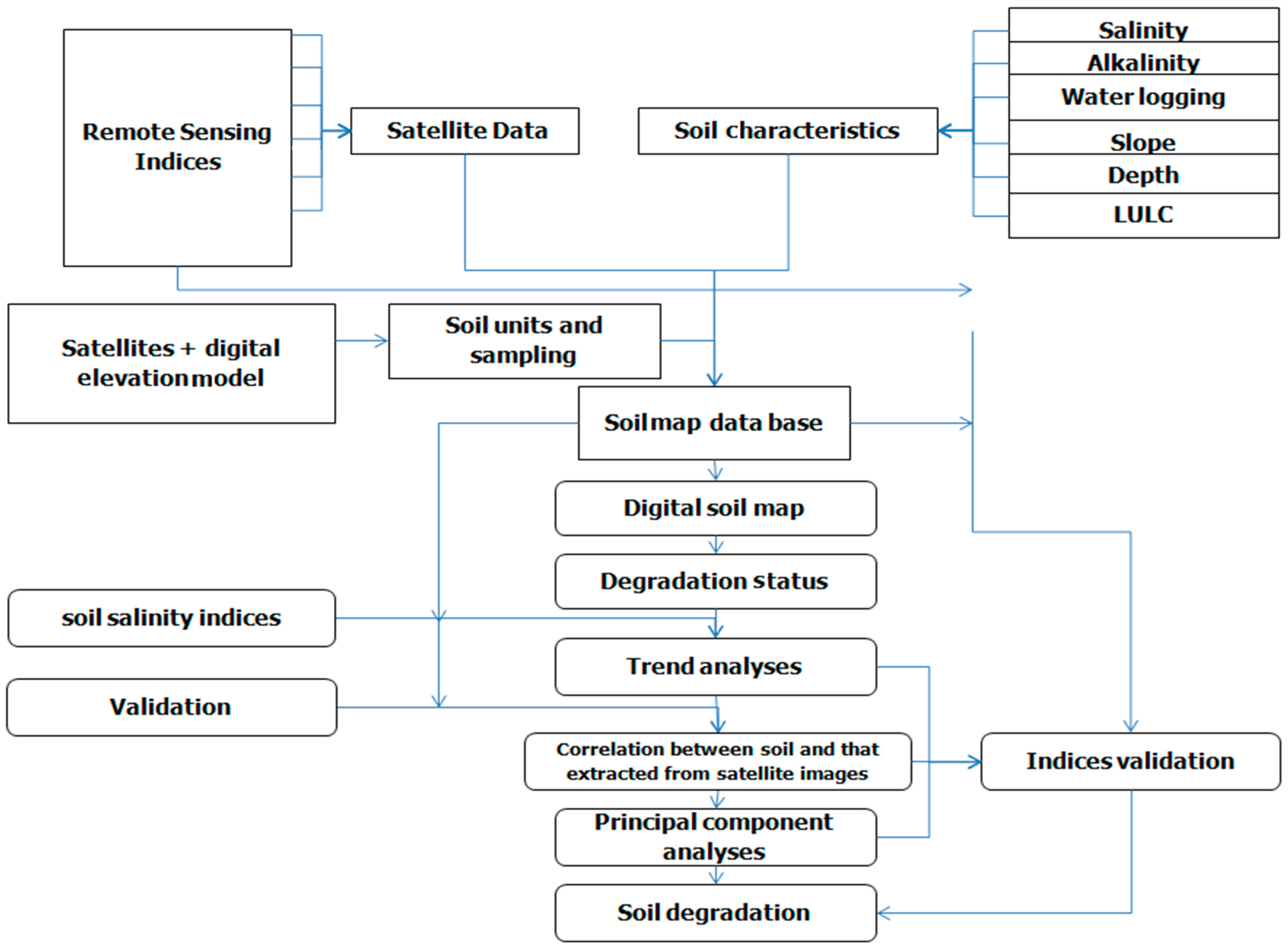
2.3. Assessment of Land Degradation
2.4. GIS Modelling Land Degradation
2.5. Multispectral Satellite Imagery
- Firstly, 215 datasets covering 10 years of 16 days for different vegetation indexes and quality images were staked.
- For each stacked image, it was possible to search and correct for missing and erroneous data (−9999, 9999). Missing pixel data values were replaced using linear interpolation of neighbouring dates in the time series of each pixel.
- The quality images were used to select dates affected by cloud and shadow for each pixel, and these values were replaced with smoothed time series vectors, by means of Savitzkye-Golay filters with window size 5 and second-order harmonic.
- It was possible to smooth the time series of each pixel by means of Savitzkye-Golay filtering with window size 5 and second-order harmonic, in order to smooth spikes and data outliers.
- Linear regression analysis was performed on the time series of each pixel to derive regression slope values and generate a map of significant trends.
3. Results
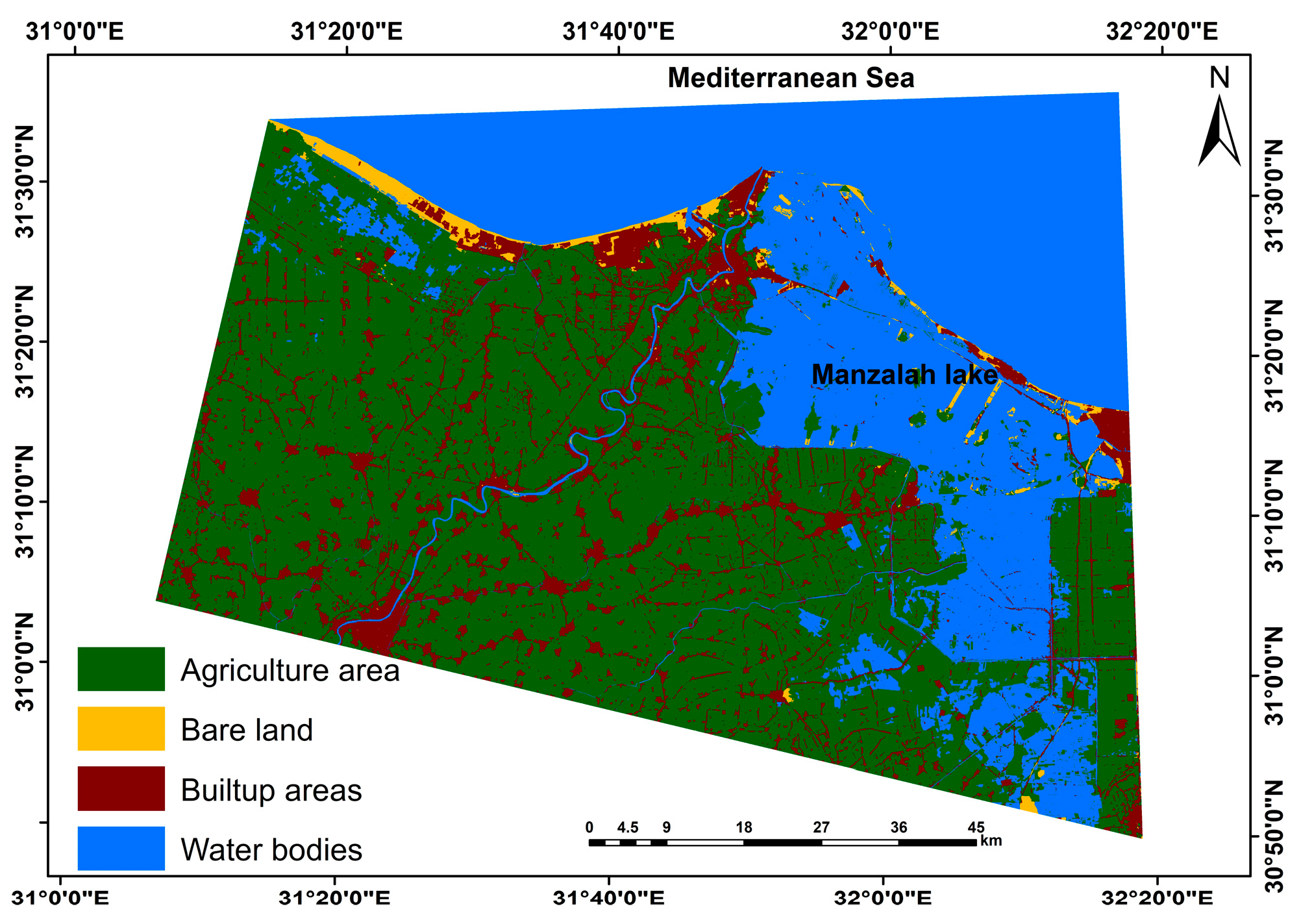
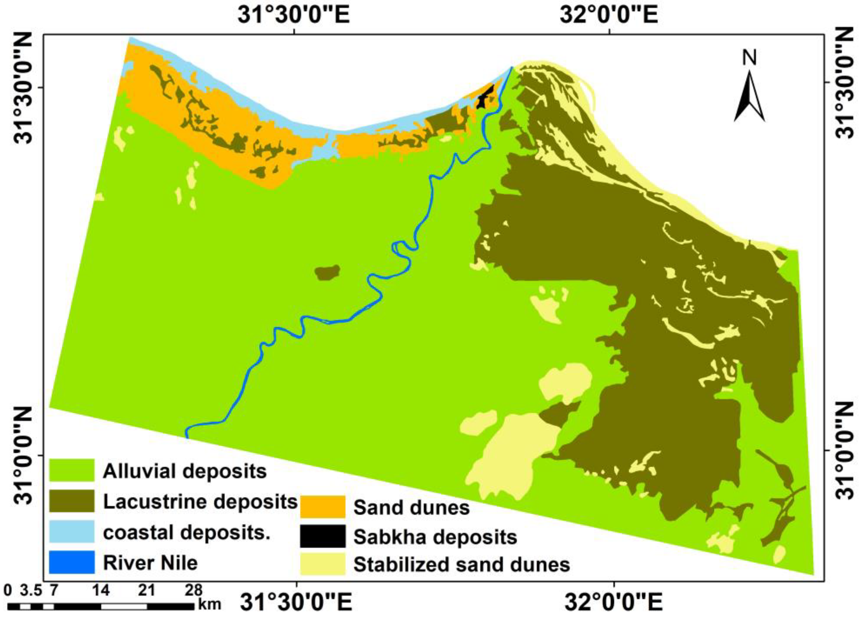
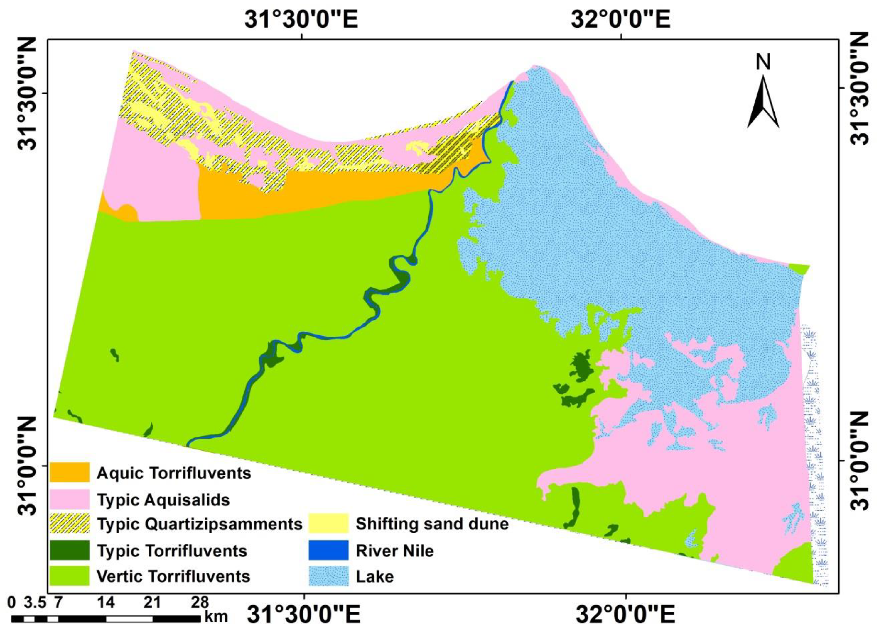
3.1. Soils of the Study Area
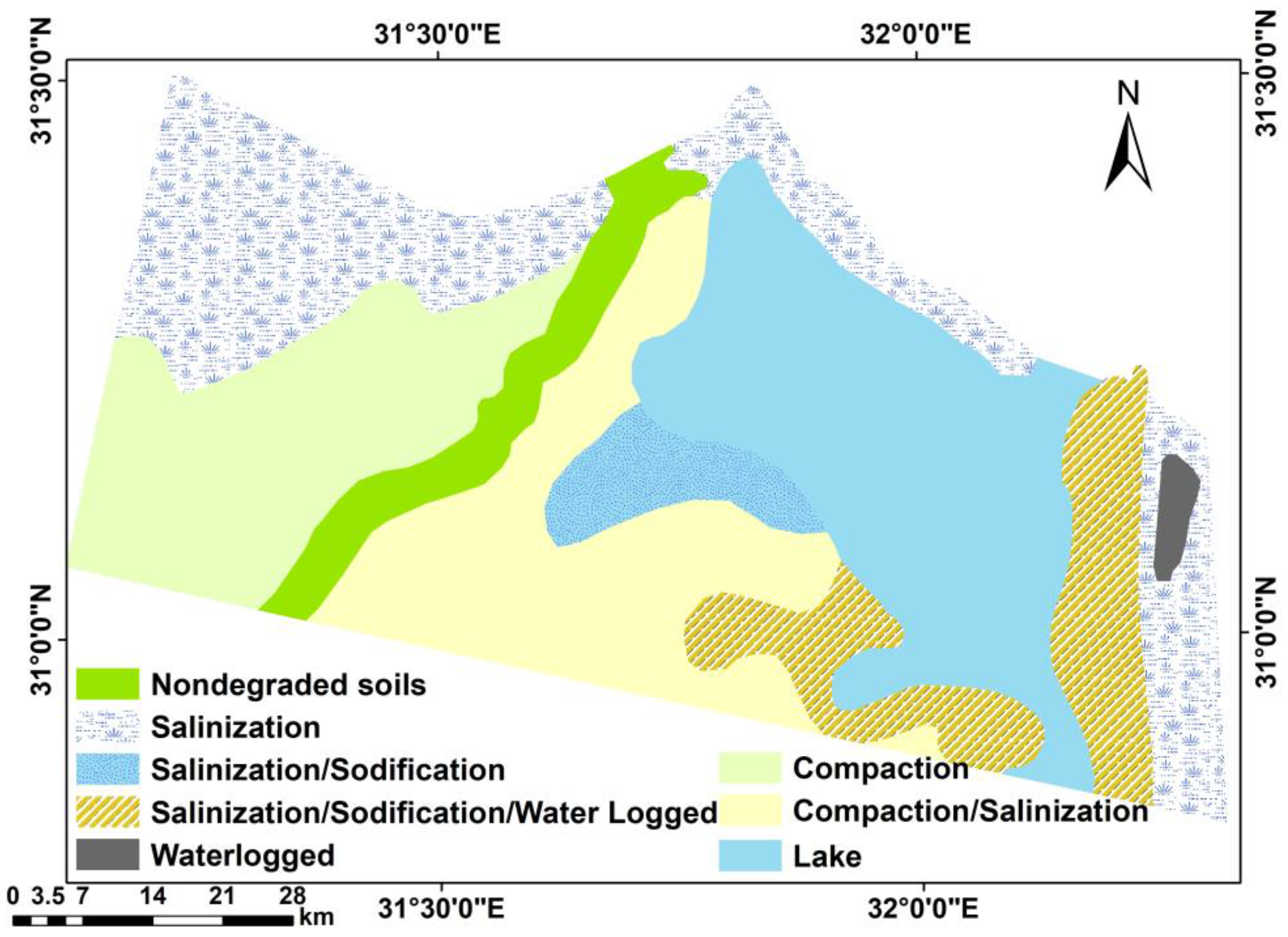
3.2. Human-Induced Soil Degradation
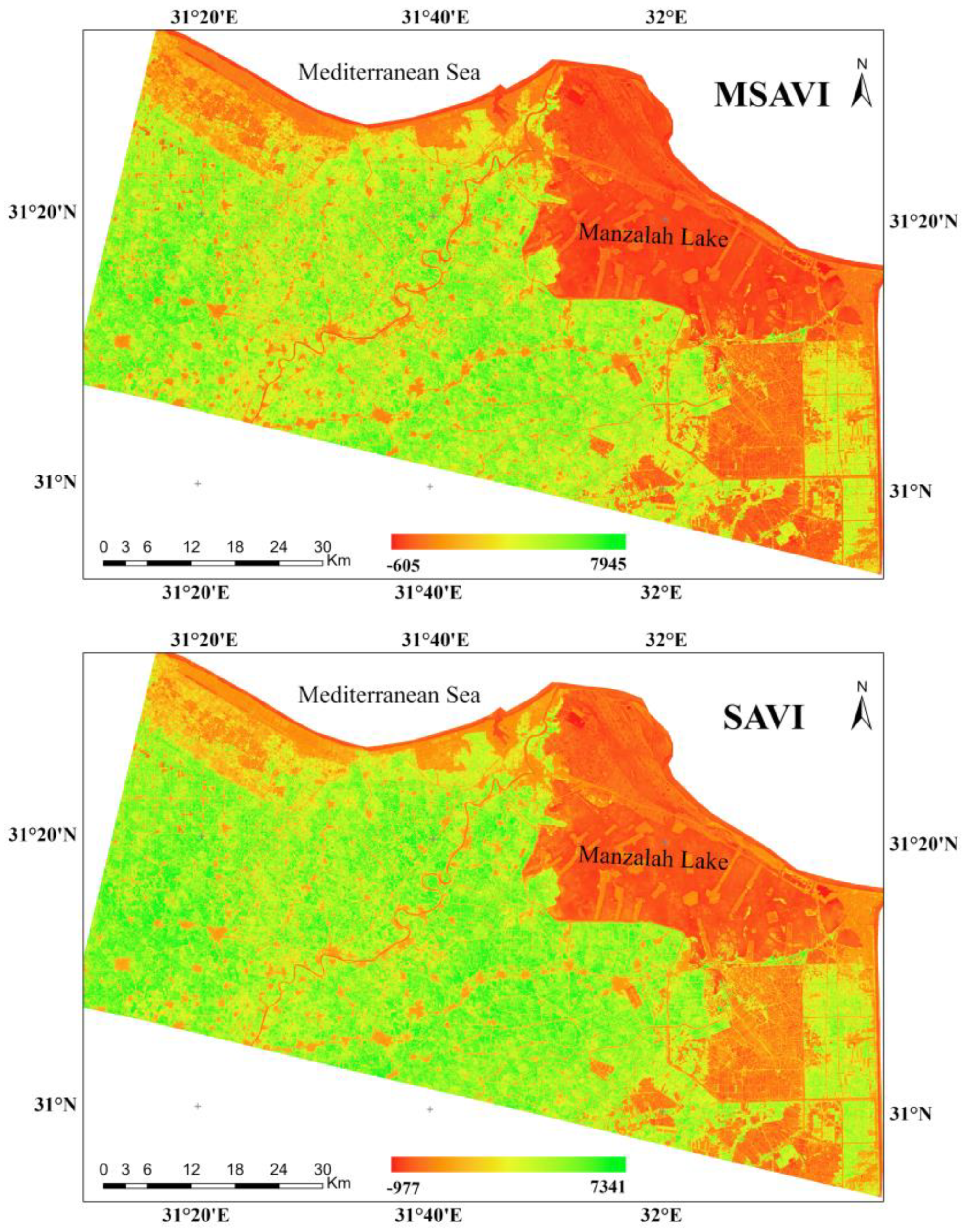
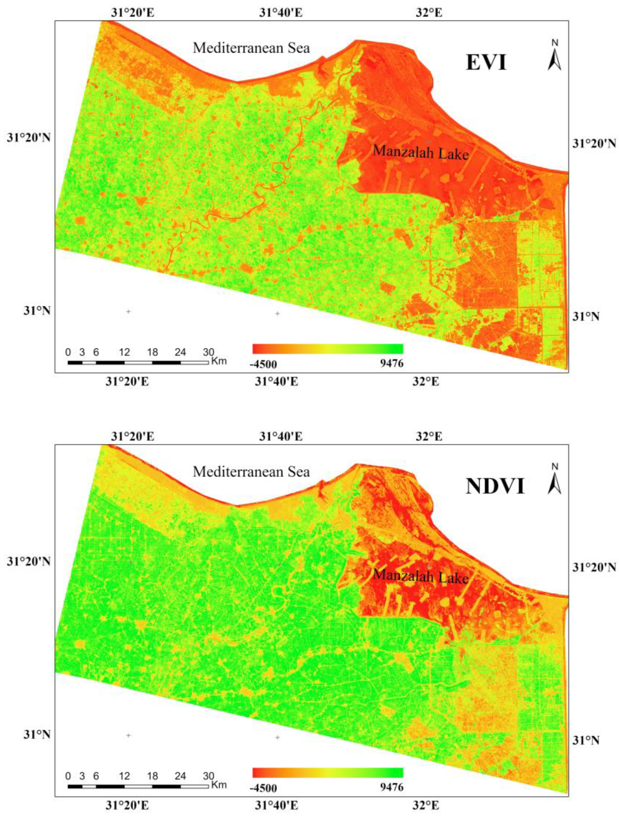
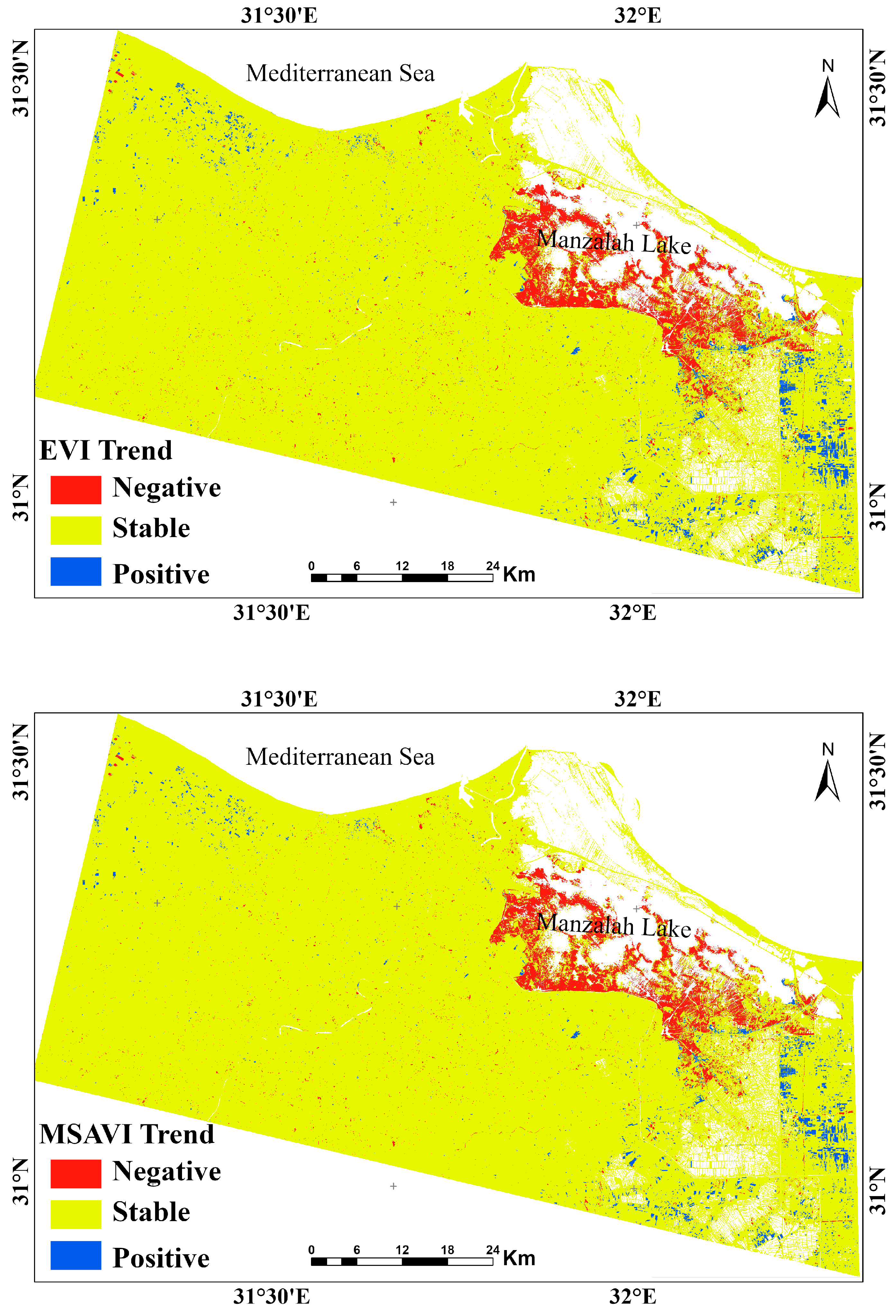
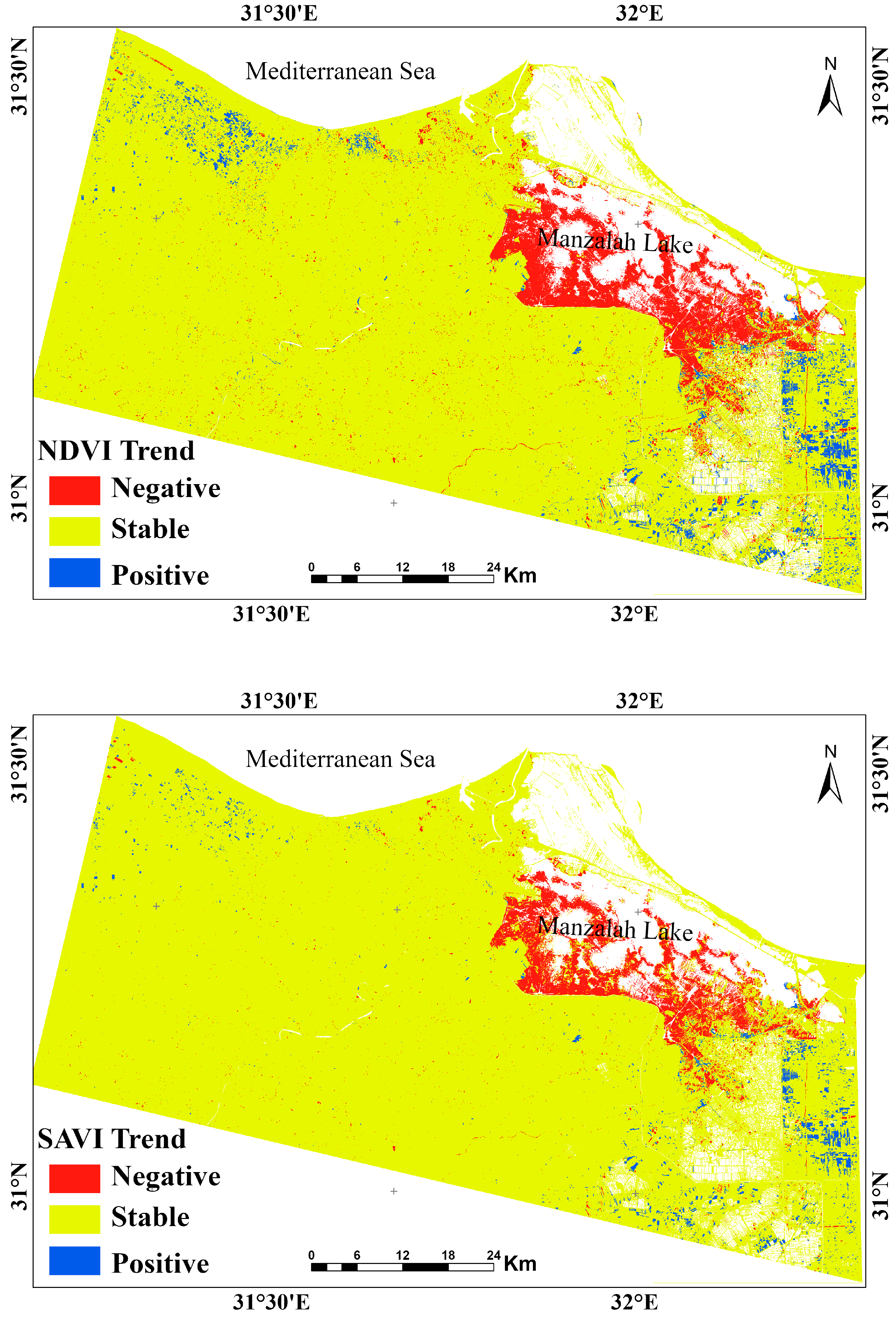
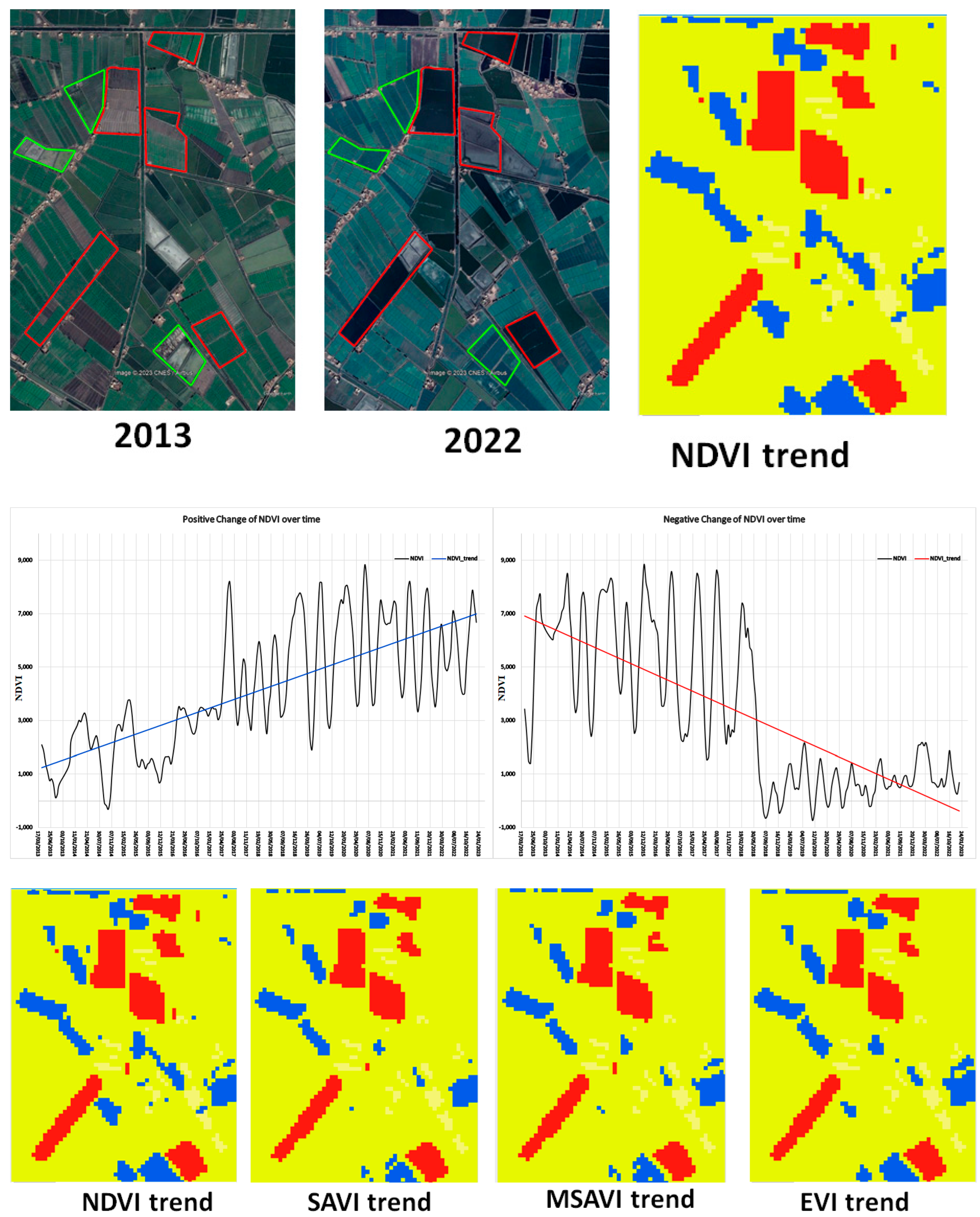
3.3. Remote Sensing Results from Landsat-8
4. Discussion
5. Conclusions
Author Contributions
Funding
Institutional Review Board Statement
Informed Consent Statement
Data Availability Statement
Acknowledgments
Conflicts of Interest
References
- Zdruli, P.; Pagliai, M.; Kapur, S.; Cano, A.F. Land Degradation and Desertification: Assessment, Mitigation and Remediation; Springer: Dordrecht, The Netherlands, 2010; pp. 1–217. [Google Scholar] [CrossRef]
- Smiraglia, D.; Ceccarelli, T.; Bajocco, S.; Salvati, L.; Perini, L. Linking trajectories of land change, land degradation processes and ecosystem services. Environ. Res. 2016, 147, 590–600. [Google Scholar] [CrossRef]
- Reed, M.S.; Stringer, L.C.; Dougill, A.J.; Perkins, J.R.; Atlhopheng, J.; Mulale, K.; Favretto, N. Reorienting land degradation towards sustainable land management: Linking sustainable livelihoods with ecosystem services in rangeland systems. J. Environ. Manag. 2015, 151, 472–485. [Google Scholar] [CrossRef] [Green Version]
- AbdelRahman, M.A.E.; Natarajan, A.; Srinivasamurty, C.A.; Hegde, R. Estimating soil fertility status in physically degraded land using GIS and remote sensing techniques in Chamarajanagar district, Karnataka, India. Egypt. J. Remote Sens. Space Sci. 2016, 19, 95–108. [Google Scholar] [CrossRef] [Green Version]
- Barbier, E.B.; Hochard, J.P. Does land degradation increase poverty in developing countries? PLoS ONE 2016, 11, e0152973. [Google Scholar] [CrossRef] [Green Version]
- Aboelsoud, H.M.; AbdelRahman, M.A.E.; Kheir, A.M.S.; Eid, M.S.M.; Ammar, K.A.; Khalifa, T.H.; Scopa, A. Quantitative Estimation of Saline-Soil Amelioration Using Remote-Sensing Indices in Arid Land for Better Management. Land 2022, 11, 1041. [Google Scholar] [CrossRef]
- AbdelRahman, M.A.E.; Afifi, A.A.; D’Antonio, P.; Gabr, S.S.; Scopa, A. Detecting and Mapping Salt-Affected Soil with Arid Integrated Indices in Feature Space using Multi-Temporal Landsat Imagery. Remote Sens. 2022, 14, 2599. [Google Scholar] [CrossRef]
- AbdelRahman, M.A.E.; Afifi, A.A.; Scopa, A. A Time Series Investigation to Assess Climate Change and Anthropogenic Impacts on Quantitative Land Degradation in the North Delta, Egypt. ISPRS Int. J. Geo-Inf. 2022, 11, 30. [Google Scholar] [CrossRef]
- Mainuri, Z.G.; Owino, J.O. Linking landforms and land use to land degradation in the Middle River Njoro Watershed. Int. Soil Water Cons. Res. 2014, 2, 1–10. [Google Scholar] [CrossRef] [Green Version]
- Uchida, S. Applicability of satellite remote sensing for mapping hazardous state of land degradation by soil erosion on agricultural areas. Procedia Environ. Sci. 2015, 24, 29–34. [Google Scholar] [CrossRef] [Green Version]
- Shoba, P.; Ramakrishnan, S.S. Modeling the contributing factors of desertification and evaluating their relationships to the soil degradation process through geomatic techniques. Solid Earth 2016, 7, 341–354. [Google Scholar] [CrossRef] [Green Version]
- Bridges, E.M.; Oldeman, L.R. Global assessment of human-induced soil degradation. Arid Soil Res. Rehabil. 1999, 13, 319–325. [Google Scholar] [CrossRef]
- Liu, C.; Sun, P.-S.; Liu, S.-R. A Review of Plant Spectral Reflectance Response to Water Physiological Changes. Chin. J. Plant Ecol. 2016, 40, 80–91. [Google Scholar] [CrossRef] [Green Version]
- Xue, J.; Su, B. Significant Remote Sensing Vegetation Indices: A Review of Developments and Applications. J. Sens. 2017, 2017, 1–17. [Google Scholar] [CrossRef] [Green Version]
- Ustuner, M.; Sanli, F.B.; Abdikan, S.; Esetlili, M.T. Crop Type Classification Using Vegetation Indices of RapidEye Imagery. ISPRS—Int. Arch. Photogramm. Remote Sens. Spat. Inf. Sci. 2014, 40, 195–198. [Google Scholar] [CrossRef] [Green Version]
- Kuzucu, A.K.; Balcik, F.B. Testing The Potential Of Vegetation Indices For Land Use/Cover Classification Using High Resolution Data. ISPRS Ann. Photogramm. Remote Sens. Spat. Inf. Sci. 2017, 4, 279–283. [Google Scholar] [CrossRef] [Green Version]
- Dou, P.; Chen, Y. Dynamic monitoring of land-use/land-cover change and urban expansion in shenzhen using landsat imagery from 1988 to 2015. Int. J. Remote Sens. 2017, 38, 5388–5407. [Google Scholar] [CrossRef]
- Zhang, Y.; Shen, W.; Li, M.; Lv, Y. Assessing spatio-temporal changes in forest cover and fragmentation under urban expansion in Nanjing, eastern China, from long-term Landsat observations (1987–2017). Appl. Geogr. 2020, 117, 102190. [Google Scholar] [CrossRef]
- Chai, B.; Li, P. Annual Urban Expansion Extraction and Spatio-Temporal Analysis Using Landsat Time Series Data: A Case Study of Tianjin. IEEE J. Sel. Top. Appl. Earth Obs. Remote Sens. 2018, 11, 2644–2656. [Google Scholar] [CrossRef]
- Schultz, M.; Clevers, J.G.P.W.; Carter, S.; Verbesselt, J.; Avitabile, V.; Quang, H.V.; Herold, M. Performance of vegetation indices from Landsat time series in deforestation monitoring. Int. J. Appl. Earth Obs. Geoinf. 2016, 52, 318–327. [Google Scholar] [CrossRef]
- Hamunyela, E.; Verbesselt, J.; Herold, M. Using spatial context to improve early detection of deforestation from Landsat time series. Remote Sens. Environ. 2016, 172, 126–138. [Google Scholar] [CrossRef]
- Souza, C.M.; Siqueira, J.V.; Sales, M.H.; Fonseca, A.V.; Ribeiro, J.G.; Numata, I.; Cochrane, M.A.; Barber, C.P.; Roberts, D.A.; Barlow, J. Ten-year landsat classification of deforestation and forest degradation in the brazilian amazon. Remote Sens. 2013, 5, 5493–5513. [Google Scholar] [CrossRef] [Green Version]
- Zhu, F.; Wang, H.; Li, M.; Diao, J.; Shen, W.; Zhang, Y.; Wu, H. Characterizing the effects of climate change on short-term post-disturbance forest recovery in southern China from Landsat time-series observations (1988–2016). Front. Earth Sci. 2020, 14, 816–827. [Google Scholar] [CrossRef]
- Mo, Y.; Kearney, M.S.; Turner, R.E. Feedback of coastal marshes to climate change: Long-term phenological shifts. Ecol. Evol. 2019, 9, 6785–6797. [Google Scholar] [CrossRef] [PubMed] [Green Version]
- Hislop, S.; Jones, S.; Soto-Berelov, M.; Skidmore, A.; Haywood, A.; Nguyen, T.H. Using landsat spectral indices in time-series to assess wildfire disturbance and recovery. Remote Sens. 2018, 10, 460. [Google Scholar] [CrossRef] [Green Version]
- Meddens, A.J.H.; Kolden, C.A.; Lutz, J.A. Detecting unburned areas within wildfire perimeters using Landsat and ancillary data across the northwestern United States. Remote Sens. Environ. 2016, 186, 275–285. [Google Scholar] [CrossRef]
- Sertel, E.; Akay, S.S. High resolution mapping of urban areas using SPOT-5 images and ancillary data. Int. J. Environ. Geoinformatics 2015, 2, 63–76. Available online: https://dergipark.org.tr/tr/download/article-file/290421 (accessed on 31 March 2023). [CrossRef] [Green Version]
- Deng, J.; Huang, Y.; Chen, B.; Tong, C.; Liu, P.; Wang, H.; Hong, Y. A methodology to monitor urban expansion and green space change using a time series of multi-sensor SPOT and Sentinel-2A images. Remote Sens. 2019, 11, 1230. [Google Scholar] [CrossRef] [Green Version]
- Qiu, C.; Schmitt, M.; Geiß, C.; Chen, T.H.K.; Zhu, X.X. A framework for large-scale mapping of human settlement extent from Sentinel-2 images via fully convolutional neural networks. ISPRS J. Photogramm. Remote Sens. 2020, 163, 152–170. [Google Scholar] [CrossRef]
- Song, Y.; Chen, B.; Kwan, M.P. How does urban expansion impact people’s exposure to green environments? A comparative study of 290 Chinese cities. J. Clean. Prod. 2020, 246, 119018. [Google Scholar] [CrossRef]
- Wulder, M.A.; Loveland, T.R.; Roy, D.P.; Crawford, C.J.; Masek, J.G.; Woodcock, C.E.; Allen, R.G.; Anderson, M.C.; Belward, A.S.; Cohen, W.B.; et al. Current status of Landsat program, science, and applications. Remote Sens. Environ. 2019, 225, 127–147. [Google Scholar] [CrossRef]
- Shiflett, S.A.; Liang, L.L.; Crum, S.M.; Feyisa, G.L.; Wang, J.; Jenerette, G.D. Variation in the urban vegetation, surface temperature, air temperature nexus. Sci. Total Environ. 2017, 579, 495–505. [Google Scholar] [CrossRef] [PubMed]
- Voogt, J.A.; Oke, T.R. Thermal remote sensing of urban climates. Remote Sens. Environ. 2003, 86, 370–384. [Google Scholar] [CrossRef]
- Estoque, R.C.; Murayama, Y. Monitoring surface urban heat island formation in a tropical mountain city using Landsat data (1987–2015). ISPRS J. Photogramm. Remote Sens. 2017, 133, 18–29. [Google Scholar] [CrossRef]
- Nurwanda, A.; Honjo, T. The Prediction of City Expansion and Land Surface Temperature in Bogor City, Indonesia. Sustain. Cities Soc. 2019, 52, 101772. [Google Scholar] [CrossRef]
- Son, N.T.; Chen, C.F.; Chen, C.R. Urban expansion and its impacts on local temperature in San Salvador, El Salvador. Urban Clim. 2020, 32, 100617. [Google Scholar] [CrossRef]
- Gamba, P.; Acqua, F.D. Increased accuracy multiband urban classification using a neuro-fuzzy classifier. Int. J. Remote Sens. 2003, 24, 827–834. [Google Scholar] [CrossRef]
- Soil Survey Staff. Keys to Soil Taxonomy; Department of Agriculture, Natural Resources Conservation Service: Washington DC, USA, 2014. [Google Scholar]
- Food and Agriculture Organization. Guidelines for Soil Description; FAO: Rome, Italy, 2006. [Google Scholar]
- Sparks, D.L.; Page, A.L.; Helmke, P.A.; Loeppert, R.H. Methods of Soil Analysis: Part 3-Chemical Methods; Soil Science Society of America, American Society of Agronomy: Madison, WI, USA, 1996. [Google Scholar]
- Klute, A. Methods of Soil Analysis: Part 1-Physical and Mineralogical Methods; Soil Science Society of America, American Society of Agronomy: Madison, WI, USA, 1986. [Google Scholar]
- Conoco. Geologic Map of Egypt. Egyptian General Authority for Petroleum (UNESCO Joint Map Project), 20 Sheets, Scale 1:50,000; Conoco Geologic Map of Egypt: Cairo, Egypt, 1987. [Google Scholar]
- Food and Agriculture Organization/UNEP and UNESCO. A Provisional Methodology for Degradation Assessment; FAO: Rome, Italy, 1979. [Google Scholar]
- Food and Agriculture Organization/International Soil Reference and Information Centre. Guiding Principles for The Quantitative Assessment of Soil Degradation With a Focus on Salinization, Nutrient Decline and Soil Pollution; AGL/MISC/36/2004; FAO: Rome, Italy, 2004. [Google Scholar]
- Soil Science Division Staff. Soil Survey Manual; USDA Handbook 18; Government Printing Office: Washington DC, USA, 2017.
- Hazelton, P.; Murphy, B. Interpreting Soil Test Results: What Do All the Numbers Mean? CSIRO Publishing: Collingwood Victoria, Australia, 2016. [Google Scholar]
- Food and Agriculture Organization. Salt-Affected Soils and Their Management; FAO Soils Bulletin No. 39; Food and Agriculture Organization: Rome, Italy, 1988. [Google Scholar]
- Gao, X.Y.; Huo, Z.L.; Bai, Y.N.; Feng, S.Y.; Huang, G.H.; Shi, H.B.; Qu, Z.Y. Soil salt and groundwater change in flood irrigation field and uncultivated land: A case study based on 4-year field observations. Environ. Earth Sci. 2015, 73, 2127–2139. [Google Scholar] [CrossRef]
- Ali, M.H. Management of Salt-Affected Soils. In Practices of Irrigation & Onfarm Water Management; Ali, M.H., Ed.; Springer: New York, NY, USA, 2011; Volume 2, pp. 271–325. [Google Scholar]
- Läuchli, A.; Grattan, S.R. Plant Growth and Development under Salinity Stress. In Advances in Molecular Breeding toward Drought and Salt Tolerant Crops; Jenks, M.A., Hasegawa, P.M., Jain, S.M., Eds.; Springer: Dordrecht, The Netherlands, 2007; pp. 1–32. [Google Scholar]
- Nawaz, M.F.; Bourrié, G.; Trolard, F. Soil compaction impact and modelling. A review. Agron. Sustain. Dev. 2013, 33, 291–309. [Google Scholar] [CrossRef] [Green Version]
- Colombi, T.; Walter, A. Genetic diversity under soil compaction in wheat: Root number as a promising trait for early plant vigor. Front. Plant Sci. 2017, 8, 420. [Google Scholar] [CrossRef] [Green Version]
- Gomathi, R.; Gururaja Rao, P.N.; Chandran, K.; Selvi, A. Adaptive Responses of Sugarcane to Waterlogging Stress: An over view. Sugar Tech. 2015, 17, 325–338. [Google Scholar] [CrossRef]
- Yue, J.; Tian, J.; Tian, Q.; Xu, K.; Xu, N. Development of soil moisture indices from differences in water absorption between shortwave-infrared bands. ISPRS J. Photogramm. Remote Sens. 2019, 154, 216–230. [Google Scholar] [CrossRef]
- Diem, P.K.; Pimple, U.; Sitthi, A.; Varnakovida, P.; Tanaka, K.; Pungkul, S.; Leadprathom, K.; LeClerc, M.Y.; Chidthaisong, A. Shifts in growing season of tropical deciduous forests as driven by El Niño and La Niña during 2001–2016. Forests 2018, 9, 448. [Google Scholar] [CrossRef] [Green Version]
- Mohd, O.; Suryanna, N.; Sahibuddin, S.S.; Abdollah, M.F. Thresholding and Fuzzy Rule-Based Classification Approaches in Handling Mangrove Forest Mixed Pixel Problems Associated with in QuickBird Remote Sensing Image Analysis. Int. J. Agric. For. 2012, 2, 300–306. [Google Scholar] [CrossRef] [Green Version]
- Estoque, R.C.; Murayama, Y.; Myint, S.W. Effects of landscape composition and pattern on land surface temperature: An urban heat island study in the megacities of Southeast Asia. Sci. Total Environ. 2017, 577, 349–359. [Google Scholar] [CrossRef]
- Du, Y.; Zhang, Y.; Ling, F.; Wang, Q.; Li, W.; Li, X. Water Bodies’ Mapping from Sentinel-2 Imagery with Modified Normalized Difference Water Index at 10-m Spatial Resolution Produced by Sharpening the SWIR Band. Remote Sens. 2016, 8, 354. [Google Scholar] [CrossRef] [Green Version]
- Mzid, N.; Pignatti, S.; Huang, W.; Casa, R. An analysis of bare soil occurrence in arable croplands for remote sensing topsoil applications. Remote Sens. 2021, 13, 474. [Google Scholar] [CrossRef]
- Qiu, B.; Zhang, K.; Tang, Z.; Chen, C.; Wang, Z. Developing soil indices based on brightness, darkness, and greenness to improve land surface mapping accuracy. GIScience Remote Sens. 2017, 54, 759–777. [Google Scholar] [CrossRef]
- Mullapudi, A.; Vibhute, A.D.; Mali, S.; Patil, C.H. Spatial and Seasonal Change Detection in Vegetation Cover Using Time-Series Landsat Satellite Images and Machine Learning Methods. SN Comput. Sci. 2023, 4, 254. [Google Scholar] [CrossRef]


| Remote Sensing Index | Calculations in Landsat-8 |
|---|---|
| Normalized Difference Vegetation Index (NDVI) | NDVI = (Band 5 − Band 4)/(Band 5 + Band 4). |
| Vegetation Condition Index (VCI) | VCI = 100 × (NDVI − NDVI min)/(NDVI max − NDVI min) |
| Normalized Difference Built-up Index (NDBI) | NDBI = (Band 6 − Band 5)/(Band 6 + Band 5) |
| Enhanced Vegetation Index (EVI) | EVI = 2.5 × [(Band 5 – Band 4)/(Band 5 + 6 × Band 4 − 7.5 × Band 2 + 1)]. |
| Temperature Condition Index (TCI) | TCI = (LST max − LST/LST max − LST min) × 100 Land Surface Temperature (LST) |
| Crop Water Stress Index (CWSI) | CWSI = LST − LST min/LST max − LST min |
| Vegetation Health Index (VHI) | VHI = a × VCI + (1 − a) × TCI, where a is a coefficient determining the contributions of the two indices |
| Soil-Adjusted Vegetation Index (SAVI) | (NIR − RED) × (1 + L)/(NIR + RED+ L) L (vegetation cover current factor). |
| Modified Soil Adjusted Vegetation Index (MSAVI) | MSAVI = (2 × Band 5 + 1 − sqrt [(2 × Band 5 + 1)2 − 8 × (Band 5 − Band 4)]/2 |
| Normalized Difference Moisture Index (NDMI) | NDMI = (Band 5 − Band 6)/(Band 5 + Band 6). |
Disclaimer/Publisher’s Note: The statements, opinions and data contained in all publications are solely those of the individual author(s) and contributor(s) and not of MDPI and/or the editor(s). MDPI and/or the editor(s) disclaim responsibility for any injury to people or property resulting from any ideas, methods, instructions or products referred to in the content. |
© 2023 by the authors. Licensee MDPI, Basel, Switzerland. This article is an open access article distributed under the terms and conditions of the Creative Commons Attribution (CC BY) license (https://creativecommons.org/licenses/by/4.0/).
Share and Cite
AbdelRahman, M.A.E.; Metwalli, M.R.; Gao, M.; Toscano, F.; Fiorentino, C.; Scopa, A.; D’Antonio, P. Determining the Extent of Soil Degradation Processes Using Trend Analyses at a Regional Multispectral Scale. Land 2023, 12, 855. https://doi.org/10.3390/land12040855
AbdelRahman MAE, Metwalli MR, Gao M, Toscano F, Fiorentino C, Scopa A, D’Antonio P. Determining the Extent of Soil Degradation Processes Using Trend Analyses at a Regional Multispectral Scale. Land. 2023; 12(4):855. https://doi.org/10.3390/land12040855
Chicago/Turabian StyleAbdelRahman, Mohamed A. E., Mohamed R. Metwalli, Maofang Gao, Francesco Toscano, Costanza Fiorentino, Antonio Scopa, and Paola D’Antonio. 2023. "Determining the Extent of Soil Degradation Processes Using Trend Analyses at a Regional Multispectral Scale" Land 12, no. 4: 855. https://doi.org/10.3390/land12040855
APA StyleAbdelRahman, M. A. E., Metwalli, M. R., Gao, M., Toscano, F., Fiorentino, C., Scopa, A., & D’Antonio, P. (2023). Determining the Extent of Soil Degradation Processes Using Trend Analyses at a Regional Multispectral Scale. Land, 12(4), 855. https://doi.org/10.3390/land12040855