

Registration of the Legal Status of Public Utilities


Abstract
:1. Introduction
2. Materials and Methods
3. Results
3.1. Registration of the Legal Status of Utilities
3.2. Completeness of Utility Registration in the Research Area
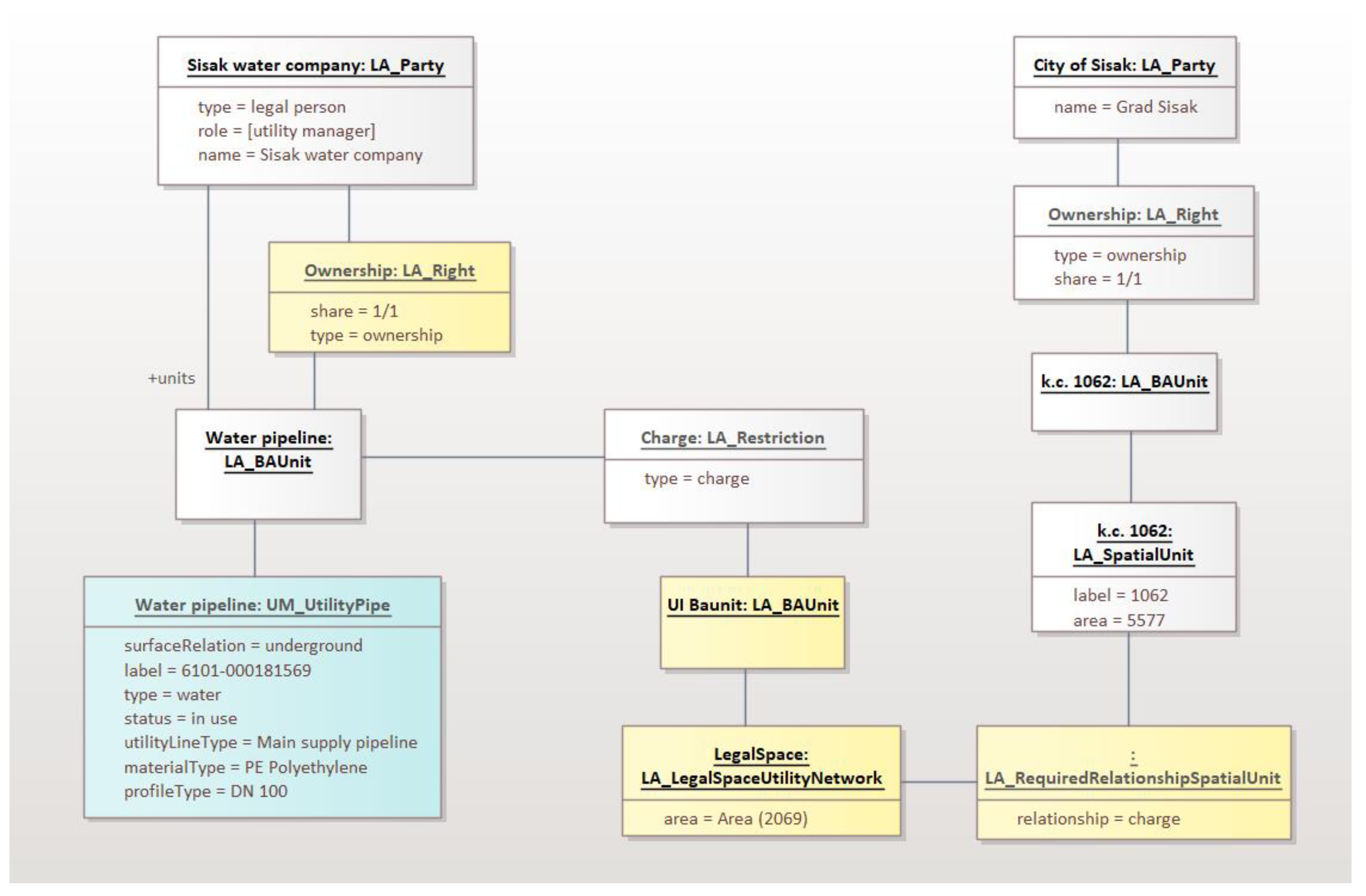
3.3. Registration of the Legal Status Based on LADM
3.4. Integral Modelling of Land and Infrastructure
4. Discussions
5. Conclusions
Author Contributions
Funding
Data Availability Statement
Conflicts of Interest
References
- Dželalija, G.; Roić, M. Bibliometrics on Public Utilities Registration Research. Land 2023, 20, 1097. [Google Scholar] [CrossRef]
- Thompson, R.; van Oosterom, P. Bi-Temporal Foundation for LADM v2: Fusing Event and State Based Modelling of Land Administration Data 2D and 3D. Land Use Policy 2021, 102, 105246. [Google Scholar] [CrossRef]
- Kim, S.; Heo, J. Development of 3D Underground Cadastral Data Model in Korea: Based on Land Administration Domain Model. Land Use Policy 2017, 60, 123–138. [Google Scholar] [CrossRef]
- Silva, W.d.O.; Carneiro, A.F.T. Subsurface Utility Network Cadastre Proposal, Based on Ladm (Iso/Fdis 19152). Bol. Cienc. Geod. 2020, 26, e2020006. [Google Scholar] [CrossRef]
- Tekavec, J.; Ferlan, M.; Lisec, A. A Review of Research on 3D Real Property Cadastre. Geod. Vestn. 2018, 62, 249–278. [Google Scholar] [CrossRef]
- Saeidian, B.; Rajabifard, A.; Atazadeh, B.; Kalantari, M. Underground Land Administration from 2d to 3d: Critical Challenges and Future Research Directions. Land 2021, 10, 1101. [Google Scholar] [CrossRef]
- Radulović, A.; Sladić, D.; Govedarica, M.; Ristić, A.; Jovanović, D. LADM Based Utility Network Cadastre in Serbia. ISPRS Int. J. Geo-Inf. 2019, 8, 206. [Google Scholar] [CrossRef]
- Paasch, J.M.; Paulsson, J. 3D Property Research from a Legal Perspective Revisited. Land 2021, 10, 494. [Google Scholar] [CrossRef]
- Dimopoulou, E.; Elia, E. Towards Common Basis for 3D Cadastres from Legal Perspective. Surv. Rev. 2013, 45, 410–418. [Google Scholar] [CrossRef]
- Kitsakis, D.; Kalogianni, E.; Dimopoulou, E. Public Law Restrictions in the Context of 3D Land Administration—Review on Legal and Technical Approaches. Land 2022, 11, 88. [Google Scholar] [CrossRef]
- Paulsson, J. Reasons for Introducing 3D Property in a Legal System-Illustrated by the Swedish Case. Land Use Policy 2013, 33, 195–203. [Google Scholar] [CrossRef]
- Yan, J.; Jaw, S.W.; Soon, K.H.; Wieser, A.; Schrotter, G. Towards an Underground Utilities 3D Data Model for Land Administration. Remote Sens. 2019, 11, 1957. [Google Scholar] [CrossRef]
- Vishnu, E.; Sameer, S. OGC CityGML 3D City Models Enriched with Utility Infrastructures for Developing Countries. J. Indian Soc. Remote Sens. 2021, 49, 813–826. [Google Scholar] [CrossRef]
- Dzelalija, G. Utility Registration Implementation Model Based on LADM; University of Zagreb: Zagreb, Croatia, 2023. [Google Scholar]
- Zaini, F.; Hussin, K.; Suratman, R.; Rasid, K.A. Underground Land Ownership in Malaysia: A Review. J. Pentadb. Tanah 2013, 3, 39–52. [Google Scholar]
- Kitsakis, D.; Kalantari, M.; Rajabifard, A.; Atazadeh, B.; Dimopoulou, E. Exploring the 3 Rd Dimension within Public Law Restrictions: A Case Study of Victoria, Australia. Land Use Policy 2019, 85, 195–206. [Google Scholar] [CrossRef]
- Kitsakis, D.; Dimopoulou, E. Assessing the Environmental Impact of 3D Public Law Restrictions. Land Use Policy 2020, 98, 104151. [Google Scholar] [CrossRef]
- Stoter, J.; Salzmann, M. Towards a 3D Cadastre: Where Do Cadastral Needs and Technical Possibilities Meet? Comput. Environ. Urban Syst. 2003, 27, 395–410. [Google Scholar] [CrossRef]
- Döner, F.; Thompson, R.; Stoter, J.; Lemmen, C.; Ploeger, H.; van Oosterom, P.; Zlatanova, S. Solutions for 4D Cadastre—With a Case Study on Utility Networks. Int. J. Geogr. Inf. Sci. 2011, 25, 1173–1189. [Google Scholar] [CrossRef]
- Yan, J.; Van Son, R.; Soon, K.H. From Underground Utility Survey to Land Administration: An Underground Utility 3D Data Model. Land Use Policy 2021, 102, 105267. [Google Scholar] [CrossRef]
- Döner, F.; Thompson, R.; Stoter, J.; Lemmen, C.; Ploeger, H.; van Oosterom, P.; Zlatanova, S. 4D Cadastres: First Analysis of Legal, Organizational, and Technical Impact-With a Case Study on Utility Networks. Land Use Policy 2010, 27, 1068–1081. [Google Scholar] [CrossRef]
- Xu, X.; Cai, H. Semantic Approach to Compliance Checking of Underground Utilities. Autom. Constr. 2020, 109, 103006. [Google Scholar] [CrossRef]
- van der Molen, P. Institutional Aspects of 3D Cadastres. Comput. Environ. Urban Syst. 2003, 27, 383–394. [Google Scholar] [CrossRef]
- Stoter, J.E.; van Oosterom, P. 3D Cadastre in an International Context: Legal, Organizational, and Technological Aspects; CRC Press: Boca Raton, FL, USA, 2006. [Google Scholar]
- Roić, M. Upravljanje Zemljišnim Informacijama Katastar; Sveučilište u Zagrebu, Geodetski Fakultet: Zagreb, Croatia, 2012. [Google Scholar]
- Vučić, N. Podrška Prijelazu Iz 2D u 3D Katastar u Republici Hrvatskoj; University of Zagreb: Zagreb, Croatia, 2015. [Google Scholar]
- Mađer, M.; Matijević, H.; Roić, M. Analysis of Possibilities for Linking Land Registers and Other Official Registers in the Republic of Croatia Based on LADM. Land Use Policy 2015, 49, 606–616. [Google Scholar] [CrossRef]
- Mader, M.; Matijevic, H.; Roić, M. Linking Land Registers and Other Official Registers in the Republic of Croatia Based on LADM Linking Land Registers and Other Official Registers in the Republic of Croatia Based on LADM. In Proceedings of the 5th Land Administration Domain Model Workshop (LADM2013), Kuala Lumpur, Malaysia, 24–25 September 2013; pp. 81–94. [Google Scholar]
- Blagonić, B. Katastar Vodova u Lokalnoj Infrastrukturi Prostornih Podataka; University of Zagreb: Zagreb, Croatia, 2012. [Google Scholar]
- Blagonić, B. Optimizacija Katastra Vodova u Lokalnoj Infrastrukturi Prostornih Podataka. Geod. List 2013, 67, 235–254. [Google Scholar]
- Pacadi, B.; Šarlah, N.; Gorgiev, V. Evidentiranje Javne Komunalne i Druge Infrastrukture u Hrvatskoj, Sloveniji i Makedoniji. In Proceedings of the MIPRO Conference, Opatija, Croatia, 20–24 May 2013; pp. 1–9. [Google Scholar]
- Ministry of Justice. Uređena Zemlja. Available online: https://oss.uredjenazemlja.hr (accessed on 17 December 2023).
- Van Oosterom, P.; Stoter, J.; Ploeger, H.D.; Thompson, R.J.; Karki, S. World-Wide Inventory of the Status of 3D Cadastres in 2010 and Expectations for 2014. In Proceedings of the FIG Working Week 2011 “Bridging the Gap between Cultures” & 6th National Congress of ONIGT, Marrakech, Morocco, 18–22 May 2011. [Google Scholar]
- Van Oosterom, P.; Stoter, J.; Ploeger, H. Initial Analysis of the Second FIG 3D Cadastres Questionnaire: Status in 2014 and Expectations for 2018. In Proceedings of the 4th International Workshop on 3D Cadastres, Dubai, United Arab Emirates, 9–11 November 2014; pp. 55–74. [Google Scholar]
- Shnaidman, A.; van Oosterom, P.J.M.; Lemmen, C.; Ploeger, H.D.; Karki, S.; Rahman, A.A. Analysis of the Third FIG 3D Cadastres Questionnaire: Status in 2018 and Expectations for 2022. In Proceedings of the FIG Working Week 2019, International Federation of Surveyors (FIG), Hanoi, Vietnam, 22–26 April 2019; p. 2022. [Google Scholar]
- Dželalija, G.; Roić, M. Utilities Data in Land Administration Systems. In Proceedings of the 7th International FIG Workshop on 3D Cadastres, New York, NY, USA, 11–13 October 2021. [Google Scholar]
- Lemmen, C.; van Oosterom, P.; Bennett, R. The Land Administration Domain Model. Land Use Policy 2015, 49, 535–545. [Google Scholar] [CrossRef]
- Dželalija, G.; Roić, M. Toward a Croatian Utility Registration Implementation Model Based on LADM. In Proceedings of the 10th Land Administration Domain Model Workshop, Dubrovnik, Croatia, 31 March–2 April 2022; Kara, A., Bennett, R., Lemmen, C., van Oosterom, P., Eds.; International Federation of Surveyors: Dubrovnik, Croatia, 2022. [Google Scholar]
- ISO 19152:2012; Geographic Information—Land Administration Domain Model. ISO: Geneva, Switzerland, 2012.
- Lemmen, C.; Van Oosterom, P.; Kara, A.; Kalogianni, E.; Shnaidman, A.; Indrajit, A.; Alattas, A. The Scope of LADM Revision Is Shaping-Up. In Proceedings of the 8th FIG Land Administration Domain Model Workshop 2019, Kuala Lumpur, Malaysia, 1–3 October 2019. [Google Scholar]
- Kalogianni, E.; Dimopoulou, E.; Gruler, H.C.; Stubkjaer, E.; Lemmen, C.; van Oosterom, P. Developing the Refined Survey Model for the LADM Revision Supporting Interoperability with LandInfra. In FIG e-Working Week 2021: Smart Surveyors for Land and Water Management-Challenges in a New Reality; International Federation of Surveyors: Copenhagen, Denmark, 2021. [Google Scholar]
- Lemmen, C.; Alattas, A.; Indrajit, A.; Kalogianni, E.; Kara, A.; Oukes, P.; van Oosterom, P. The Foundation of Edition II of the Land Administration Domain Model. In Proceedings of the 9th FIG Workshop on the Land Administration Domain Model/3D Land Administration, Virtual, The Netherlands, 20–25 June 2021; pp. 21–25. [Google Scholar]
- Lemmen, C.H.J.; van Oosterom, P.J.M.; Unger, E.-M.; Kalogianni, E.; Shnaidman, A.; Kara, A.; Alattas, A.; Indrajit, A.; Smyth, K.; Milledrogues, A.; et al. The Land Administration Domain Model: Advancement and Implementation. In Proceedings of the (Cancelled) Annual World Bank Conference on Land and Poverty 2020: Institutions for Equity & Resilience, Washington, WA, USA, 16–20 March 2020. [Google Scholar]


| Utility Network | Utility Lines | Lines Length | Utility Line Nodes |
|---|---|---|---|
| Electricity | 5693 | 693.3 km | 1501 |
| Electronic communication | 61,937 | 1752.8 km | 20,461 |
| Heat | 813 | 35.1 km | 519 |
| Gas | 90 | 32.1 km | 57 |
| Oil | 60 | 36.4 km | 65 |
| Water | 9672 | 445.2 km | 15,895 |
| Sewage | 4195 | 172 km | 5668 |
| Total | 82,460 | 3167 km | 44,166 |
| Utility Network | Parcels Crossed | Registered Charges | % |
|---|---|---|---|
| Electricity | 14,660 | 1447 | 9.9 |
| Electronic communication | 16,993 | 84 | 0.5 |
| Heat | 502 | 111 | 22.1 |
| Gas | 257 | 3 | 1.2 |
| Oil | 259 | 179 | 69.1 |
| Water | 10,809 | 1041 | 9.6 |
| Sewage | 3039 | 340 | 11.2 |
| Situation | Logical Link | Spatial Link |
|---|---|---|
| Change of utility infrastructure ownership | Change in charge holder necessary. | No additional changes needed. |
| Changes on cadastral parcel | Update on charge record needed. | No additional changes needed. |
| Charge geometry | No charge geometry. | Has charge geometry. |
| Number of charges | One charge record per Land Book entry. | One charge record per utility infrastructure. |
Disclaimer/Publisher’s Note: The statements, opinions and data contained in all publications are solely those of the individual author(s) and contributor(s) and not of MDPI and/or the editor(s). MDPI and/or the editor(s) disclaim responsibility for any injury to people or property resulting from any ideas, methods, instructions or products referred to in the content. |
© 2024 by the authors. Licensee MDPI, Basel, Switzerland. This article is an open access article distributed under the terms and conditions of the Creative Commons Attribution (CC BY) license (https://creativecommons.org/licenses/by/4.0/).
Share and Cite
Roić, M.; Dželalija, G. Registration of the Legal Status of Public Utilities. Land 2024, 13, 209. https://doi.org/10.3390/land13020209
Roić M, Dželalija G. Registration of the Legal Status of Public Utilities. Land. 2024; 13(2):209. https://doi.org/10.3390/land13020209
Chicago/Turabian StyleRoić, Miodrag, and Grgo Dželalija. 2024. "Registration of the Legal Status of Public Utilities" Land 13, no. 2: 209. https://doi.org/10.3390/land13020209
APA StyleRoić, M., & Dželalija, G. (2024). Registration of the Legal Status of Public Utilities. Land, 13(2), 209. https://doi.org/10.3390/land13020209