
Bridging Sustainable Development Goals and Land Administration: The Role of the ISO 19152 Land Administration Domain Model in SDG Indicator Formalization †

 , ,
, , 
Abstract
:1. Introduction
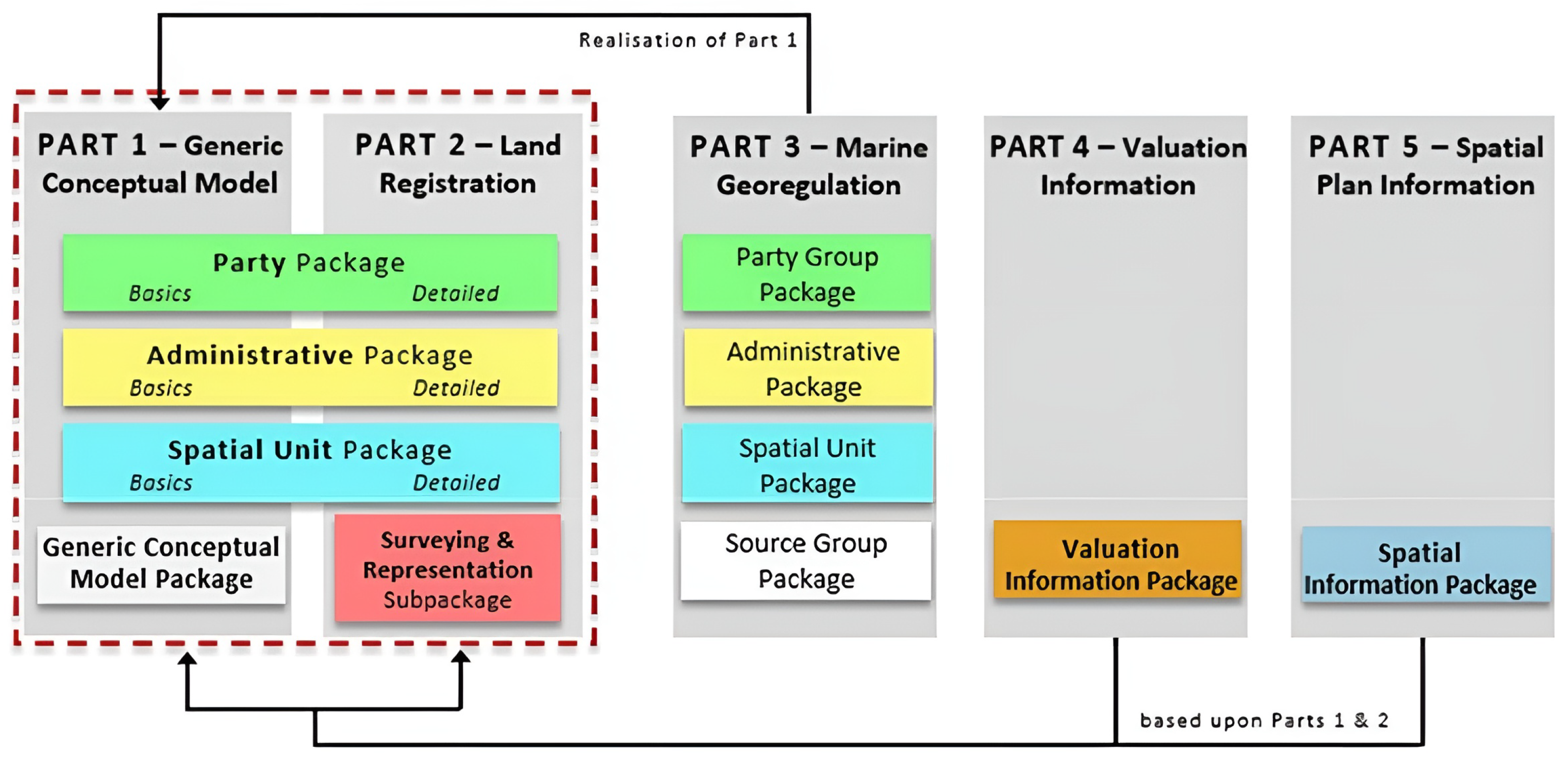
1.1. ISO 19152:2012 LADM Basic Concepts and Ongoing Revision
1.2. UN Sustainable Development Goals (SDGs) and Metadata
2. Materials and Methods
- By amalgamating the standardized principles and methodologies of the ISO 19152 LADM with the overarching goals and targets of the UN Agenda 2030, the resulting land administration indicators will manifest as more comprehensive, accurate and representative.
- The utilization of these indicators has the potential to bolster evidence-based policymaking, thereby substantively contributing to the realization of the SDGs.
- The effectiveness and expediency of indicator computation can be significantly enhanced through continuous updates to the land administration system (LAS).
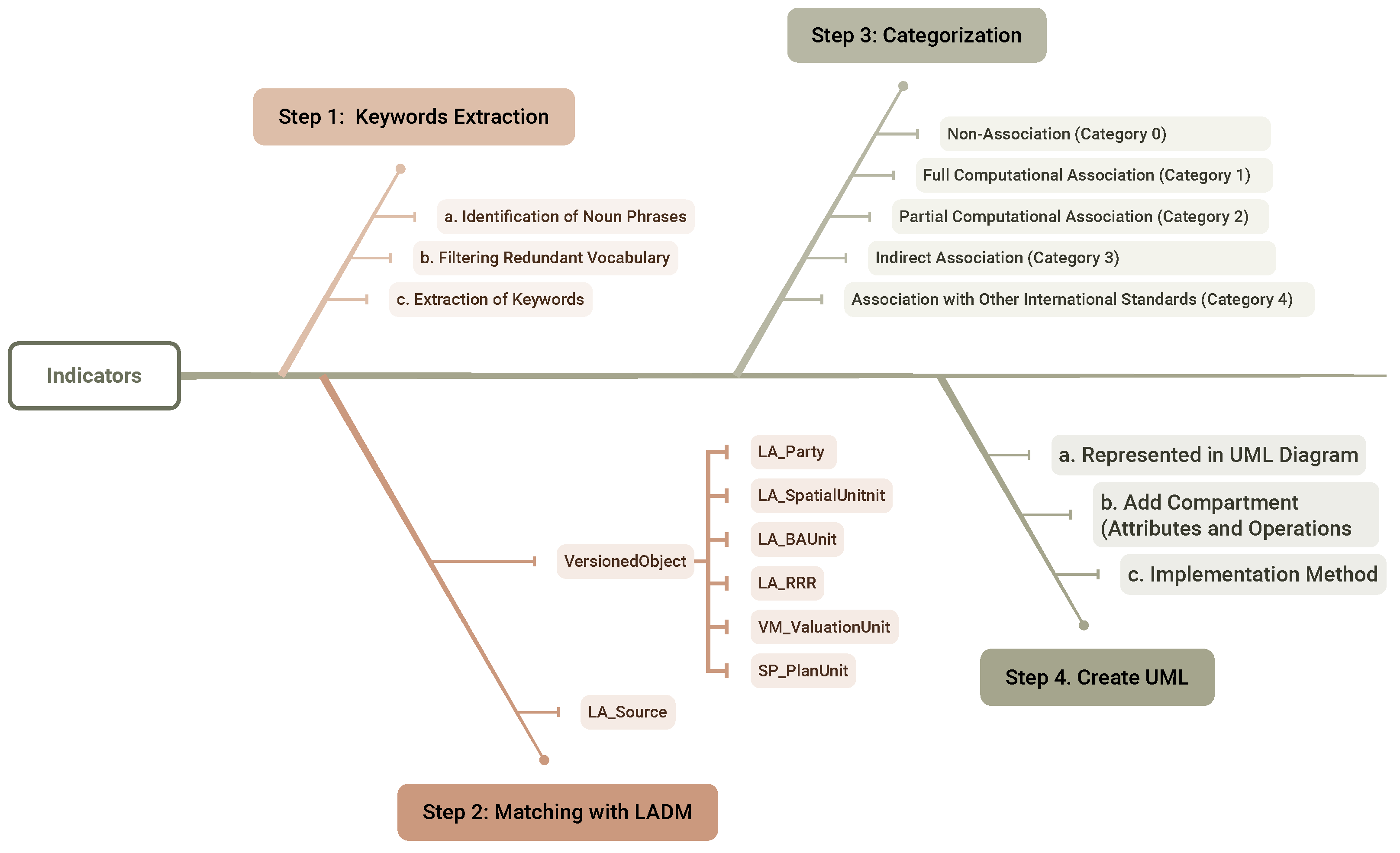
Indicator Selection and Classification
- Step 1:
- Keyword Extraction and Preliminary Filtering
- Land: the spatial extent that is defined by RRRs and encompasses the surface of the earth, strata, sub-strata or the marine environment, like a building.
- Party: a person or organization that plays a role in a rights, responsibilities, or restrictions transaction, like a natural person.
- Right: formal or informal entitlement to own or do something.
- Responsibility: formal or informal obligation on the land owner to allow or do something.
- Restriction: formal or informal obligation on the land owner to refrain from doing something.
- Spatial Units: the areas of land (or water, e.g., water rights and the marine environment) where the rights and social tenure relationships apply.
- Marine: relating to navigation or shipping; relating to or connected with the sea; used or adopted for use at sea.
- Valuation: the process of estimating the value of an immovable property.
- (a)
- value: the value of a property or a property unit estimated under certain assumptions at a particular moment in time.
- Spatial Plan: a set of documents that indicates a strategic direction for the development of a given geographic area, states the policies, priorities, programs, and land allocations that will implement the strategic direction and influences the distribution of people and activities in spaces of various scales.
- (a)
- plan unit: homogenous smallest area/space (2D/3D) with an assigned function/purpose to represent the potential land use development according to the spatial planning authorities at the highest detail and largest scale (usually the municipality/ neighborhood level)
- Source: document providing legal and/or administrative facts on which the LA object [right, restriction, responsibility, basic administrative unit, party, or spatial unit] is based on.
- Step 2:
- Matching SDGs with LADM core classes
- For “0.f. Related indicators”. It identifies related indicators to understand their connections and potential overlaps, aiding in defining the evaluation scope. For example, for Indicator 5.1.1, “Whether or not legal frameworks are in place to promote, enforce and monitor equality and non-discrimination on the basis of sex”, to avoid duplication, it does not cover areas of law that are addressed under Indicator 5.a.2, “Proportion of countries where the legal framework (including customary law” guarantees women’s equal rights to land ownership and/or control);
- For “2.a. Definition and concepts”. It provides explanations for the more generalized text used in the indicators. For example, for Indicator 1.4.1, “Proportion of population living in households with access to basic services”, the precise definition of “basic services” is elaborated upon;
- For “3.a. Data sources”. It gives information on the potential databases and the organizations responsible for data collection, allowing for a quick assessment of whether they are relevant to the data involved in the LADM;
- For “4.c. Method of Computation”. The specific calculation methods for each indicator are detailed, which encompass a variety of approaches, like the formulation of mathematical equations, tabulated scoring systems, etc. This section also plays a pivotal role in the subsequent classification of indicators.
- Step 3:
- Indicator Categorization
- Non-Association (Category 0): These indicators demonstrate no discernible direct or computational correlation with the LADM.
- Full Computational Association (Category 1): Indicators falling within this category exhibit an unequivocal and comprehensive computational interdependence with the LADM. All data required for the calculation of these indicators can be obtained from a land administration system that conforms to the LADM.
- Partial Computational Association (Category 2): These indicators, while partly reliant on data provided by the LADM for their calculations, necessitate additional external data sources. They thus have a partial computational connection to the LADM.
- Indirect Association (Category 3): The LADM offers supportive roles during the indicator generation process. These roles are:
- (a)
- Indicator involves LADM elements (classes or attributes) but lacks direct expression (and therefore calculation) within the structure of the model. For example, for the indicator “14.6.1 Degree of implementation of international instruments aiming to combat illegal, unreported and unregulated fishing”, the computation method is based on surveys and scoring, and it is related to elements such as marine and land rights within the LADM.
- (b)
- Indicator indirectly utilizes LADM elements, and their final expressions do not have a direct relation with the LADM. For instance, in the indicator “1.2.2 Proportion of men, women and children of all ages living in poverty in all its dimensions according to national definitions”, “Poverty” includes a “housing” dimension, which is related to “BAUnit”.
- Association with Other Standards (Category 4): Indicators categorized as such are fundamentally linked with other (international) standards to be computed and potentially may partly rely on the LADM.
- Step 4:
- Create UML
- Represented in a UML Diagram: UML class diagrams are developed to express all the information needed to calculate the indicators from the SDG metadata document, specifically:
- (a)
- Information that can be directly represented by packages within the current version of the LADM [5].
- (b)
- Information that has a well-defined source and can be linked from UML external classes to other databases. While the construction of external databases encompassing party data, address data, taxation data, land cover data, physical utility network data, earth surface data and archive data falls outside the scope of the LADM, the LADM provides stereotype classes for these data sets, which indicate what data set elements the LADM expects from these external sources.
- (c)
- Information that will be output in an interface class.
- Add compartment: For the most relevant class, a dedicated compartment is used for the computation of the indicator values. This compartment contains the name and parameters of the added operations. It is noted that the spatial extent (country, province, municipality) and temporal extent (decade, year, month) may vary. A typical operation could be to compute an indicator value in a specific year and for a specific area, e.g., compute indicator X (year, area).
- Implementation Method: For each operation, a well-defined implementation method is specified within the UML diagram. This includes an attached note defining the steps of computation. The implementation methods are articulated using programming languages (i.e., Python, Java, pseudo-code). Crucially, these methods were aligned with the information elements delineated in the utilized UML classes.
- Interface Class: For each indicator, the resulting values, as produced by the three mentioned components above, are conveniently represented in so-called interface classes. In the LADM, interface classes are used in other situations where information is collected from other classes and somehow combined, e.g., LA_SpatialUnitOverview (i.e., cadastral map) or LA_PartyPortfolio, also collecting and aggregating information from other LADM classes.
- Add color: To enhance readability, distinct colors are utilized to represent various elements: green signifies classes from the Party Package, yellow denotes classes from the Administrative Package, blue represents classes from the Spatial Unit Package, white indicates the Source Class, orange is used for classes from the Valuation Information Package, greyish blue is used for classes from the Spatial Information Package, purple signifies External Classes, brown denotes interface classes and light pink highlights methods that implement operations. Text highlighted in red emphasizes components that are crucial for the computation of the indicator.
3. Results
3.1. LADM Part 2: Land Registration with SDG 1.4.2
3.1.1. Indicator Classification
- Part (A) quantifies the proportion of adults possessing legally recognized documentation over land within the total adult population.
- Part (B) emphasizes the proportion of adults who perceive their land rights as secure within the adult population.
- The number of adults possessing legally recognized documentation over land (for Part A), which can be derived from a land administration system compliant with the LADM;
- The number of adults who perceive their land rights as secure (for Part B), which can only be obtained through household surveys (or relevant historical data stored in external databases);
- The total adult population (for both), made available from censuses or inter-censual projections.
- “Secure tenure rights” and “type of tenure” are related to the LA_RRR (Rights, Responsibilities, Restrictions) class due to their connection to the nature of land rights.
- “Legally recognized documentation”, as mentioned in the metadata file, is legal documentation of rights that refers to the recording and publication of information on the nature and location of land, rights and right holders recognized by the government. So, it is related to LA_Source.
- “Sex” should be an attribute of LA_Party [31].
3.1.2. Indicator Development (Step 4: Create UML)
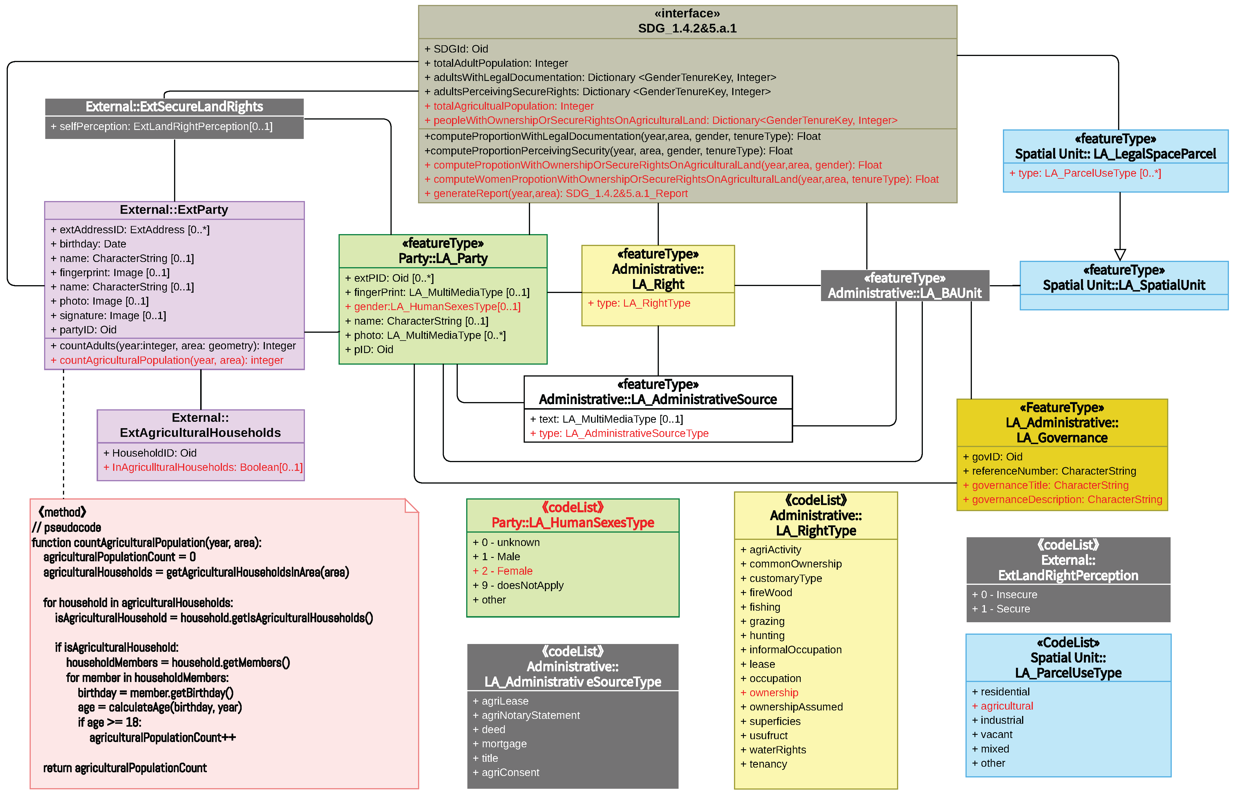
- Represented in the UML Diagram: The core classes of the LADM (LA_Party, LA_RRR, LA_BAUnit, and LA_Source) in the UML diagram describing the indicator computation are introduced. To fulfill the requirements of SDG Indicator 1.4.2, an external class named “ExtSecureLandRightAdult” is introduced to represent the molecular aspect of Part B and an external class named “ExtParty”.
- Implementation Method: Having completed the addition of attributes and operations, the third step is concerned with developing a method for the logic required to calculate the indicator to ensure that the previously established theoretical framework is translated into workable algorithms. This includes the methods “computeProportionWithLegalDocumentation”, which calculates the proportion of adults with legally recognized land rights documentation; “computeProportionPerceivingSecurity”, which computes the proportion of adults perceiving land rights as secure; “generateReport”, which synthesizes data into a comprehensive report; and “countAdults”, which determines the total count of adults. The final UML diagram for SDG 1.4.2 is shown in Figure 5.
3.2. LADM Part 2: Land Registration and SDG 5.a.1
3.2.1. Indicator Classification
- Sub-indicator 5.a.1 (a): measurement of the proportion of the agricultural population with ownership or secure rights over agricultural land, disaggregated by sex, is intended to reveal the distribution of men and women in terms of their rights and interests in agricultural land.
- Sub-indicator 5.a.1 (b) focuses on gender parity and reflects the current status of gender disparities in agriculture by measuring whether women are disadvantaged relative to men in terms of access to ownership or secure rights over agricultural land.
- The number of people in the agricultural population. This refers to the population of adult individuals living in agricultural households. While the LADM has the class LA_GroupParty to represent group party, it lacks a specific attribute for “agricultural family”. Consequently, these data need to be sourced externally, such as from agricultural surveys, general household surveys (GHSs) or agricultural censuses. This information can be effectively represented using the External::ExtParty Class or by expanding the LA_GroupPartyType codelist to include a value for “agricultural family”.
- The number of people with ownership or secure rights over agricultural land. For “agricultural land”, the metadata specify that “Land is considered ‘agricultural land’ according to its use”. LA_ParcelUseType is a code list in the LADM spatial unit package that corresponds to “agricultural land” and contains an “agricultural” value to describe parcels of land that are used for agricultural purposes. For “ownership or secure rights”, considering the diversity in land ownership systems across countries and the need for comparability, the metadata specify that “to determine whether an individual is said to have ownership or secure rights to agricultural land three conditions (proxies) are considered: Formal documentation: Proxy 1—Presence of legally recognized documents in the name of the individual; Alienation rights: Proxy 2—Right to sell and Proxy 3—Right to bequeath”. Specifically,
- (a)
- Formal documentation: This is the existence of any document that an individual can use to claim property rights before the law over an asset by virtue of the individual’s name being listed as owner/co-owner or holder/co-holder on the document. Correspondingly, within the administrative package of the LADM, there is a code list named LA_AdministrativeSourceType, which represents the type of document, such as title, deed, agricultural lease, etc.
- (b)
- Alienation rights: In the absence of formal written documentation, rights to sell and bequeath are considered objective facts that carry legal force as opposed to a simple self-reported declaration of tenure rights over land. This implies the necessity for a legal context to support these rights. Although LADM Part 2 does not explicitly have a specialized class for legal content, LADM Part 3 includes a new object: the “Governance”. The class MG_Governance has been included to allow for the description of the context information from a proclamation, law or treaty document. This addition enriches the administrative structure by allowing legal texts to be associated with an administrative unit. Consequently, to address this need within the LADM, it would be feasible to introduce a class akin to “LA_Governance”. This class would serve to represent the legal context and governance information, providing a structured representation of legal frameworks relevant to land rights.
3.2.2. Indicator Development (Step 4: Create UML)
- Represented in a UML Diagram: The UML diagram for 5.a.1 builds upon the structure established for 1.4.2, with enhancements to accommodate the specifics of agricultural land tenure and legal context. Notable additions include LA_SpatialUnit and its subclass LA_LegalSpaceParcel for identifying agricultural land, LA_Governance for legal context and legal information, and ExtAgriculturalHouseholds for details related to agricultural households. To distinguish these new components, the classes used only in 1.4.2 are grey, and those used in 5.a.1 are colored.
- Add Compartment (Attributes and Operations): According to Table 4, the modifications or additions to the 1.4.2 UML diagram are required; otherwise, they remain unchanged.
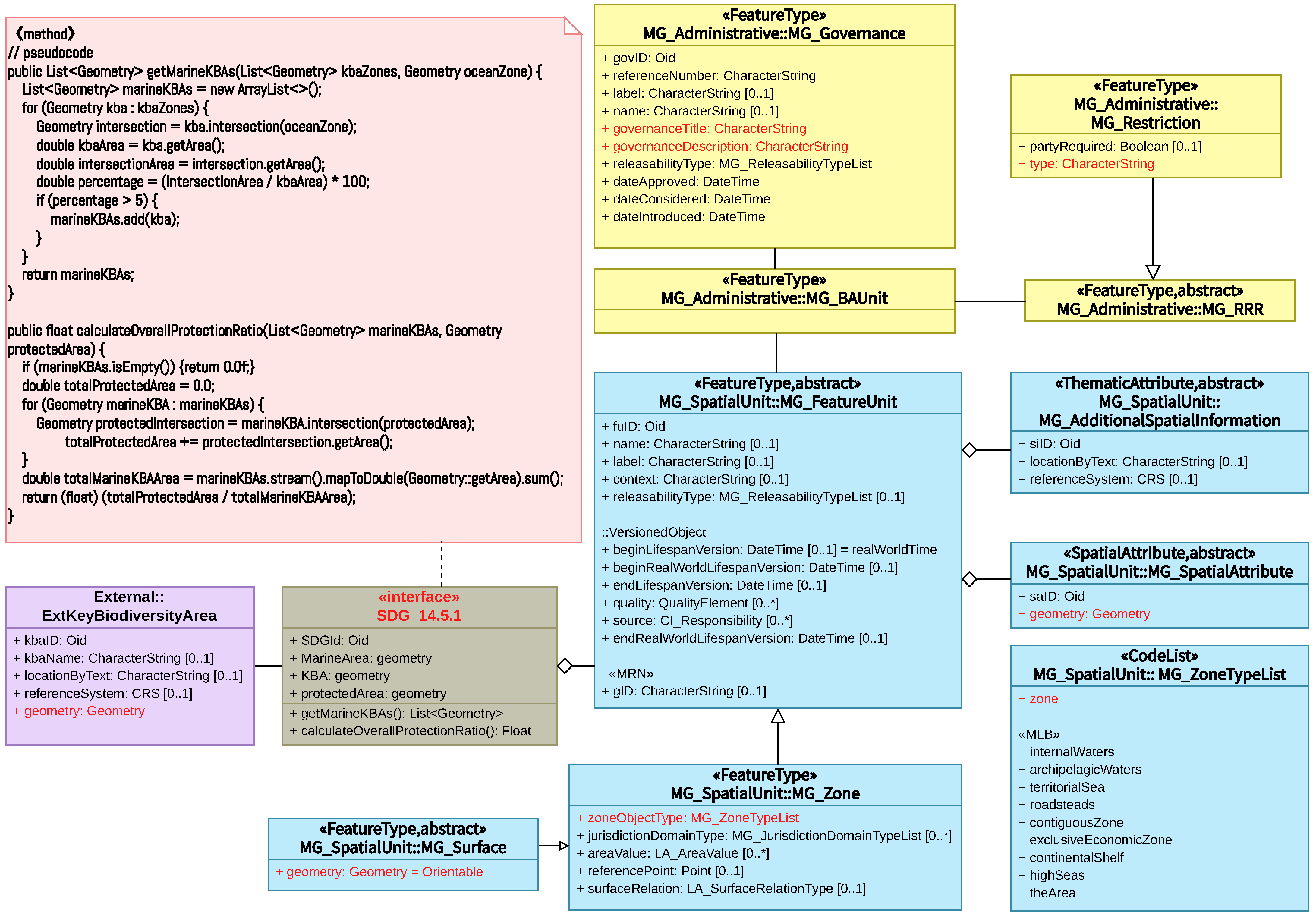
3.3. LADM Part 3: Marine Georegulation and SDG 14.5.1
3.3.1. Indicator Classification
- Data on protected areas are sourced from the World Database on Protected Areas (WDPA), and the World Database on OECM (WDOECM). Although these databases provide well-organized information, theoretically, similar data can be derived from the LADM. Notably, the LADM can offer high-precision two-dimensional polygon files, retain pertinent legal information, and extend to three-dimensional volume files, paving the way for future expansions.
- Data on Key Biodiversity Areas (KBAs), sourced from the World Database on Key Biodiversity Areas (WDKBA). It is worth noting that this specific data set cannot be directly obtained from the LADM.
- Ocean area: In LADM Part 3, MG_Zone includes the attribute “+ zoneObjectType”, with a code list MG_ZoneTypeList. The code list describes categories that have a common characteristic related to the legal and administrative aspects of the marine environment.
3.3.2. Indicator Development (Step 4: Create UML)
- + getMarineKBAs(): List<Geometry>: This operation is dedicated to identifying and retrieving all zones classified as Marine Key Biodiversity Areas (marine KBAs). These zones are discerned by computing the intersection of marine areas (MarineArea) with Key Biodiversity Areas (KBAs), followed by filtering based on the criterion that the intersected area constitutes over 5% of the total area of the KBA.
- (a)
- Data Acquisition: Extract all KBA zones (sourced from + KBA: Geometry) along with the comprehensive marine area (+ MarineArea: Geometry).
- (b)
- Intersection Computation: For each KBA zone, calculate its spatial intersection with the marine area.
- (c)
- Percentage Calculation: Ascertain the percentage of the intersected area relative to the total area of the KBA.
- (d)
- Identification of marine KBAs: Filter to select those zones where the intersected area exceeds 5% of the total KBA area, designating them as marine KBAs.
- (e)
- Output: Generate a list of geometrical objects representing all identified marine KBAs.
- + calculateOverallProtectionRatio(): Float: This operation computes the ratio of the total area designated as protected within the marine KBAs to the overall area of marine KBAs.
- (a)
- Data Acquisition: Employ the getMarineKBAs() method to amass all marine KBAs and retrieve the geometrical representation of protected areas (+protectedArea: Geometry).
- (b)
- Protected Area Computation: For each marine KBA, determine the intersection with the protected area and cumulatively sum the area of these intersections to represent the total protected area.
- (c)
- Total Area Computation: Calculate the aggregate area encompassing all marine KBAs.
- (d)
- Ratio Computation: Establish the ratio of the total protected area to the total area of marine KBAs.
- (e)
- Output: Yield the calculated ratio, signifying the overall coverage rate of protected zones within marine KBAs.

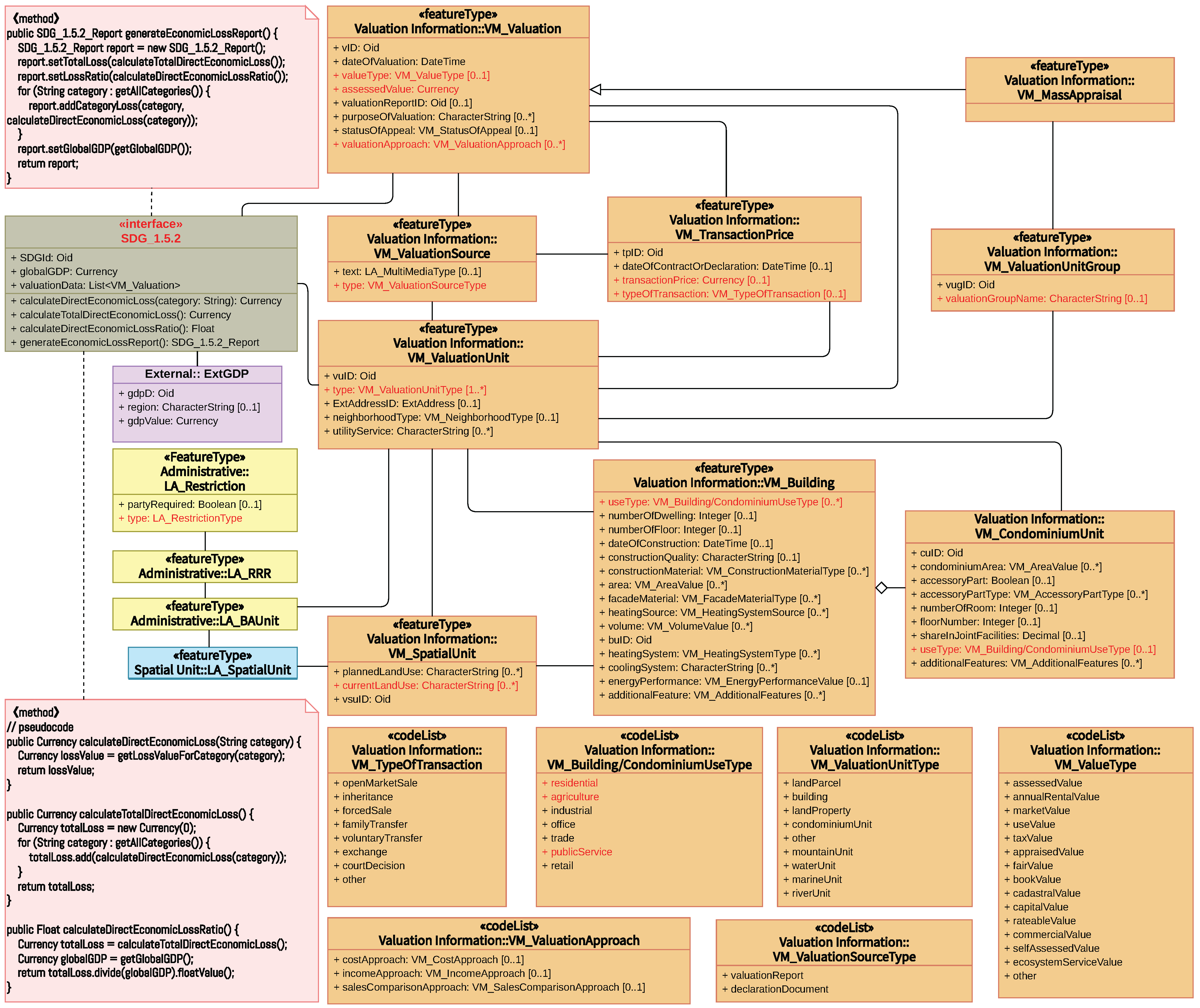
3.4. LADM Part 4: Valuation Information and SDG 11.5.2
3.4.1. Indicator Classification
- C2 (Direct Agricultural Loss): This encompasses losses in both agricultural products and productive assets. In the LADM, this can be correlated with VM_ValuationUnit, which represents the basic administrative units of valuation registries. It covers various objects of valuation, including land parcels (VM_SpatialUnit) and buildings (VM_Building) that are essential in agricultural settings.
- C3 (Economic Loss to Productive Assets): This category covers losses to assets in various economic sectors, with the LADM specifically detailing information for physical assets like industrial, office and trade buildings. This is identified using the “useType” attribute in the VM_CondominiumUnit class from the LADM.
- C4 (Housing Sector Loss): This relates to residential buildings, which are directly classified under the “residential” category in the VM_CondominiumUnit class of the LADM.
- C5 (Loss to Critical Infrastructure): This includes losses to essential buildings, roads and other infrastructure. The buildings part of the critical infrastructure can be identified under the “publicService” category in VM_Building’s “useType”. For road-related losses, the “currentLandUse” attribute of VM_SpatialUnit in the LADM can be used, with the possibility of being classified as “road”.
- C6 (Loss to Cultural Heritage): Although Part 4 of the LADM does not have a specific class for cultural heritage, the LA_Restriction class can provide insights. Protected areas, often encompassing cultural heritage sites, can be inferred from LA_Restriction’s “protected” attribute.
3.4.2. Indicator Development (Step 4: Create UML)
- “+ calculateDirectEconomicLoss(category: String): Currency”: This method calculates the direct economic loss for a specified category of assets, such as agriculture, housing or infrastructure, post-disaster. It leverages the valuation information within the VM_ValuationUnit to quantify the damage in monetary terms.
- “+ calculateTotalDirectEconomicLoss(): Currency”: The summation is predicated on the outputs from the “ + calculateDirectEconomicLoss” method for each category.
- “+ calculateDirectEconomicLossRatio(): Float”: This method computes the ratio of the total direct economic loss to the global GDP. It requires interfacing with the ExtGDP class to retrieve the global GDP value and utilizes the total direct economic loss computed by the calculateTotalDirectEconomicLoss method.
- “+ generateEconomicLossReport(): SDG_1.5.2_Report”: A comprehensive synthesis method that amalgamates all computed data and contextual information into a report.
4. Discussion
- Land Registration and SDG 1.4.2: The first case study focuses on the integration of the LADM’s land registration component with SDG Indicator 1.4.2, which measures the proportion of the adult population with secure rights to land. By mapping legal documentation of ownership and perceived security of rights to key elements of the LADM (such as LA_Party, LA_RRR, LA_Source), this study reveals the framework’s capability in ensuring the security of land rights.
- Agricultural Land Rights and SDG 5.a.1: The second case examines agricultural land rights (SDG Indicator 5.a.1) from a gender equality perspective, exploring land rights issues. The land registration and rights components of the LADM are utilized to analyze the proportion of the agricultural population, particularly women, who have secure rights to agricultural land, highlighting the LADM’s application in promoting gender equality and land rights.
- Marine Area Management and SDG 14.5.1: The third case turns its attention to the LADM’s marine area management and its combination with SDG Indicator 14.5.1 (the coverage of protected marine areas). The application of the LADM in defining and managing protected areas and marine zones demonstrates how effective management of marine protected areas can support biodiversity conservation goals.
- Land and Property Valuation and SDGs 11.5.2: The fourth case explores the relationship between the LADM’s land and property valuation component and SDG indicators 11.5.2 (direct economic loss attributed to disasters as a proportion of global GDP). Through estimating and calculating economic losses, this case showcases the potential application of the LADM in disaster risk assessment and management.
5. Conclusions
- Expand on Implementation Studies: The theoretical method developed in this research should be applied to actual data from different countries and regions. This will help in assessing the LADM’s applicability and effectiveness in diverse legal and cultural settings.
- Identify and Address Gaps: By integrating real-world data, future work can bridge the gaps between current land management practices and the ideal scenarios envisaged by LADM and SDG integration. Identifying these gaps is crucial for developing targeted strategies to address them.
- Improve Policies and Systems: Use the insights gained from practical applications of the LADM in supporting SDGs to provide concrete recommendations for governments and policymakers. This will aid in improving land management systems and policies to better align with sustainable development goals.
- Conduct Formal Standardization: The obtained results will be exploited by the editorial team for LADM revisions in order to discuss them within ISO TC211 and/or the LandAdmin DWG. Valuable insights can be used in Part 2: Land Registration, Part 3: Marine Georegulation, and Part 4: Valuation Information, while the calculation of relevant indicators could be part of discussions regarding the development of Part 6: Implementations.
Author Contributions
Funding
Data Availability Statement
Conflicts of Interest
References
- Morton, S.; Pencheon, D.; Squires, N. Sustainable Development Goals (SDGs), and their implementation: A national global framework for health, development and equity needs a systems approach at every level. Br. Med. Bull. 2017, 124, 81–90. [Google Scholar]
- Williamson, I.; Enemark, S.; Wallace, J.; Rajabifard, A. Land Administration for Sustainable Development; ESRI Press Academic: Redlands, CA, USA, 2010. [Google Scholar]
- UN-GGIM. Framework for Effective Land Administration 2020. August 2021, New York, United States. Available online: https://ggim.un.org/meetings/GGIM-committee/10th-Session/documents/E-C.20-2020-29-Add_2-Framework-for-Effective-Land-Administration.pdf (accessed on 10 February 2024).
- ISO 19152:2012; Geographic Information–Land Administration Domain Model (LADM). International Organisation for Standardisation: Geneva, Switzerland, 2012.
- Kara, A.; Lemmen, C.; van Oosterom, P.; Kalogianni, E.; Alattas, A.; Indrajit, A. Design of the new structure and capabilities of LADM edition II including 3D aspects. Land Use Policy 2024, 137, 107003. [Google Scholar] [CrossRef]
- ISO/tc211/wg7n262; Final Report from Stage 0 Project on ISO 19152 LADM. International Organization for Standardization (ISO): Geneva, Switzerland, 2019.
- Unger, E.M.; Bennett, R.M.; Lemmen, C.; Zevenbergen, J. LADM for sustainable development: An exploratory study on the application of domain-specific data models to support the SDGs. Land Use Policy 2021, 108, 105499. [Google Scholar] [CrossRef]
- UN-Habitat and World Bank. SDG Indicator Metadata-01-04-02. 2021. Available online: https://unstats.un.org/sdgs/metadata/files/Metadata-01-04-02.pdf (accessed on 10 February 2024).
- Food and Agriculture Organization of the United Nations (FAO). SDG Indicator Metadata-05-0a-01. 2023. Available online: https://unstats.un.org/sdgs/metadata/files/Metadata-05-0a-01.pdf (accessed on 10 February 2024).
- BirdLife International (BLI); International Union for Conservation of Nature (IUCN). SDG Indicator Metadata-14-05-01. 2022. Available online: https://unstats.un.org/sdgs/metadata/files/Metadata-14-05-01.pdf (accessed on 10 February 2024).
- United Nations Office for Disaster Reduction (UNISDR). SDG Indicator Metadata-11-05-02. 2018. Available online: https://unstats.un.org/sdgs/metadata/files/Metadata-11-05-02.pdf (accessed on 10 February 2024).
- Kalogianni, E.; Janečka, K.; Kalantari, M.; Dimopoulou, E.; Bydłosz, J.; Radulović, A.; Vučić, N.; Sladić, D.; Govedarica, M.; Lemmen, C.; et al. Methodology for the development of LADM country profiles. Land Use Policy 2021, 105, 105380. [Google Scholar] [CrossRef]
- Enemark, S.; Mclaren, R.; Lemmen, C. Fit-for-Purpose Land Administration: Guiding Principles for Country Implementation. 2016. Available online: https://www.researchgate.net/publication/305659772_Fit-For-Purpose_Land_Administration_Guiding_Principles_for_Country_Implementation/citations#fullTextFileContent (accessed on 10 February 2024).
- Aditya, T.; Sucaya, I.K.G.A.; Adi, F.N. LADM-compliant field data collector for cadastral surveyors. Land Use Policy 2021, 104, 105356. [Google Scholar] [CrossRef]
- Beck, A.; Stow, D.; Hill, M. Generic concepts to support country profiles, LADM implementation and indexing within formal Land Registers. In FIG e-Working Week; 2021; Available online: https://www.fig.net/resources/proceedings/fig_proceedings/fig2021/papers/ws_03.1/WS_03.1_beck_stowe_et_al_11228.pdf (accessed on 10 February 2024).
- Lisjak, J.; Roić, M.; Tomić, H.; Mastelić Ivić, S. Croatian LADM profile extension for state-owned agricultural land management. Land 2021, 10, 222. [Google Scholar] [CrossRef]
- Augustinus, C. Social tenure domain model: What it can mean for the land industry and for the poor. In Proceedings of the XXIV FIG International Congress: Facing the Challenges, Building the Capacity, Sydney, Australia, 11–16 April 2010. [Google Scholar]
- Williamson, I.; Enemark, S.; Wallace, J. Sustainability and land administration systems. In Proceedings of the Expert Group Meeting on Incorporating Sustainable Development Objectives into ICT Enabled Land Administration Systems, Melbourne, Australia, 9–11 November 2005; Available online: https://eng.unimelb.edu.au/__data/assets/pdf_file/0010/3925162/sustainability-landadministration-systems.pdf (accessed on 10 February 2024).
- Kalogianni, E.; van Oosterom, P.; Schmitz, M.; Capua, R.; Verbree, E.; Dimopoulou, E.; Gruler, H.C.; Stubkjær, E.; Neudiens, I.; Guarin, J.M.; et al. Galileo High Accuracy Services: Support through ISO 19162 LADM Edition II. In Proceedings of the FIG Working Week 2023: Protecting Our World, Conquering New Frontiers, Orlando, FL, USA, 28 May–1 June 2023. [Google Scholar]
- ISO 19152-1:2024; Geographic Information—Land Administration Domain Model (LADM)—Part 1: Generic Conceptual Model. International Organization for Standardization (ISO): Geneva, Switzerland, 2024.
- Kalfas, D.; Kalogiannidis, S.; Chatzitheodoridis, F.; Toska, E. Urbanization and land use planning for achieving the sustainable development goals (SDGs): A case study of Greece. Urban Sci. 2023, 7, 43. [Google Scholar] [CrossRef]
- Salmerón-Manzano, E.; Manzano-Agugliaro, F. Worldwide research trends on land tenure. Land Use Policy 2023, 131, 106727. [Google Scholar] [CrossRef]
- Huntington, H.; Stevens, C. Taking stock of global land indicators: A comparative analysis of approaches for a globally consistent land tenure security measure. Land Use Policy 2023, 124, 106376. [Google Scholar] [CrossRef]
- Pradhan, P.; Costa, L.; Rybski, D.; Lucht, W.; Kropp, J.P. A systematic study of sustainable development goal (SDG) interactions. Earth’s Future 2017, 5, 1169–1179. [Google Scholar] [CrossRef]
- Hák, T.; Janoušková, S.; Moldan, B. Sustainable Development Goals: A need for relevant indicators. Ecol. Indic. 2016, 60, 565–573. [Google Scholar] [CrossRef]
- Fraisl, D.; Campbell, J.; See, L.; Wehn, U.; Wardlaw, J.; Gold, M.; Moorthy, I.; Arias, R.; Piera, J.; Oliver, J.L.; et al. Mapping citizen science contributions to the UN sustainable development goals. Sustain. Sci. 2020, 15, 1735–1751. [Google Scholar] [CrossRef]
- World Bank (WB). SDG Indicator Metadata-01-01-01a. 2023. Available online: https://unstats.un.org/sdgs/metadata/files/Metadata-01-01-01a.pdf (accessed on 10 February 2024).
- The Food and Agriculture Organization of the United Nations (FAO). SDG Indicator Metadata-12-03-01A. 2022. Available online: https://unstats.un.org/sdgs/metadata/files/Metadata-12-03-01A.pdf (accessed on 10 February 2024).
- United Nations Environment Programme (UNEP). SDG Indicator Metadata-12-03-01B. 2023. Available online: https://unstats.un.org/sdgs/metadata/files/Metadata-12-03-01B.pdf (accessed on 10 February 2024).
- The United Nations Statistics Division (UNSD). SDG Indicators Metadata Repository. 2024. Available online: https://unstats.un.org/sdgs/metadata (accessed on 10 February 2024).
- Unger, E.M.; Lemmen, C.; Bennett, R. Women’s access to land and the Land Administration Domain Model (LADM): Requirements, modelling and assessment. Land Use Policy 2023, 126, 106538. [Google Scholar] [CrossRef]
- ISO/IEC 5218:2022; Information Technology—Codes for the Representation of Human Sexes. ISO/IEC JTC 1: Geneva, Switzerland, 2022.
- Dudley, N. Guidelines for Applying Protected Area Management Categories; Iucn: Gland, Switzerland, 2008. [Google Scholar]
- ISO 19144-2:2023; Geographic Information—Classification Systems—Part 2: Land Cover Meta Language (LCML). International Organization for Standardization (ISO): Geneva, Switzerland, 2023.
- ISO 19107:2019; Geographic Information—Spatial Schema. International Organization for Standardization (ISO): Geneva, Switzerland, 2019.


| Indicator No. | Indicator Full Name | Abbreviation in This Paper |
|---|---|---|
| 1.4.2 | “Proportion of total adult population with secure tenure rights to land, (a) with legally recognized documentation, and (b) who perceive their rights to land as secure, by sex and type of tenure.” | 1.4.2 (secure land rights) |
| 5.a.1 | “(a) Proportion of total agricultural population with ownership or secure rights over agricultural land, by sex; and (b) share of women among owners or rights-bearers of agricultural land, by type of tenure.” | 5.a.1 (women agricultural land rights) |
| 14.5.1 | “Coverage of protected areas in relation to marine areas.” | 14.5.1 (protected marine areas) |
| 11.5.2 | “Direct economic loss attributed to disasters in relation to global gross domestic product (GDP)” | 11.5.2 (valuation as basis for direct economic loss) |
| Existing LADM Class | Attributes Used in the Case | Notes |
|---|---|---|
| LA_Party | “+gender:LA_HumanSexesType[0..1]” | Highlighted to facilitate gender-based classification and calculation [31,32]. |
| LA_Right | “LA_RightType” | Delineates various land tenure types, echoing the “type of tenure” parameter in the indicator. The specific right types are detailed in the “Code List”. |
| LA_AdministrativeSource | “+ type: LA_AdministrativeSourceType” | Signifies “Legally recognized documentation”. Its codelist meticulously enumerates the possible value, like agriLease, deed and title. |
| LA_BAUnit | While not the focal point, it is outlined to underscore the indicator’s emphasis on rights over land. |
| New Class | Attributes Used in the Case | Operations | Notes for Class |
|---|---|---|---|
| External::ExtParty, | “+ birthday: Date” | “countAdult”, facilitates the determination of the total adult count | Associated with national population databases; emphasizes the attribute birthday for determining adulthood. |
| External::ExtPartyPer ceiveSecureLandRights, | “+ selfPerception: ExtL andRightPerception[0..1]” | Primarily sourced from household surveys. “1” indicates perceived security of land rights, and “0” indicates insecurity. | |
| Interface:: SDG_1.4.2 | “+ totalAdult Population: Integer” | The total adult population of a given region in a given year. These data are obtained from the External::ExtParty class, specifically from the birthday attribute, using the “countAdult” operation to calculate the total number of adults in an area. Has a pivotal role by encapsulating the final computations of the indicator values. It operates as an aggregated construct, amalgamating and interpreting data sourced from the various classes and external entities. | |
| “+ adultsWithLegal Documentation: Dictionary <GenderTenureKey, Integer>” | Aggregated information from LA_Party, LA_Right, and LA_AdministrativeSource classes. The LA_Party class provides information about parties (individuals or organizations), the LA_Right class represents legal rights associated with land and the LA_AdministrativeSource class provides information about the legal recognition of such rights through documents. Together, these classes help determine which adults have legally recognized documentation of land rights, categorized by gender and type of tenure. “GenderTenureKey” is a composite key used in the “Dictionary<GenderTenureKey, Integer>”. It consists of “+ gender: LA_HumanSexesType” from LA_Party and “+ rightType: LA_RightType” from LA_Right. | ||
| “+ adultsPerceiving SecureRights: Dictionary <GenderTenureKey, Integer>” | Aggregated information from External::ExtPartyPerceiveSecureLandRights and External::ExtParty classes. The former provides information on those who consider their land rights to be secure (i.e., + selfPerception = 1) and the latter provides information on adults. Combined, they help to summarize the adults who consider their land rights to be secure, disaggregated by gender and tenure type. | ||
| “+computeProportion WithLegalDocument ation(year, area, gender, tenureType): Float” | This operation calculates the proportion of adults possessing legally recognized documentation for land rights, factoring in variables such as spatial extent, temporal context, gender and type of land tenure. |
| Class | Attributes Used in the Case | Operations | Notes for Class |
|---|---|---|---|
| LA_LegalSpaceParcel | “+ type: LA_ParcelUseType [0..*]” | LA_ParcelUseType is a codelist, which includes “agricultural” to denote parcels used for agriculture. | |
| LA_Governance | “governanceTitle” | Provide the title of the governance document | |
| “governanceDescription” | Detail the governance statement | ||
| External::ExtAgricultural-Households | “+ InAgriculturalHouseholds: Boolean[0..1]” | To ascertain if an individual is part of an agricultural household. | |
| External::ExtParty | “+ countAgriculturalPopulation(year, area): integer” | To determine the total agricultural population within a specified period and area. | |
| Interface Class:: SDG_1.4.2&5.a.1 | “+ totalAgriculturalPop: Integer” | Derived from ExtParty | |
| “+ peopleWithOwnershipOrSecureRightsOnAgriculturalLand: Dictionary<GenderTenureKey, Integer>” | To aggregate information from the classes LA_Party, LA_Right, LA_BAUnit, LA_SpatialUnit and LA_Governance | ||
| “+ computeProportionWithOwnershipOrSecureRightsOnAgriculturalLand (year, area, gender): Float” | To calculate the proportion of the agricultural population with ownership or secure rights over agricultural land, disaggregated by gender | ||
| “+ computeWomenProportionWithOwnershipOrSecureRightsOnAgriculturalLand(year, area, tenureType): Float” | To assess the share of women among those with ownership or secure rights over agricultural land, disaggregated by tenure type. | ||
| “+ generateReport(year, area): SDG_1.4.2&5.a.1_Report” | To synthesize the computed data into a comprehensive report. |
| Method | Purpose | Implementation Steps | Details |
|---|---|---|---|
| + countAgriculturalPopulation(year, area): integer | Calculates the total number of individuals in agricultural households within a specified geographical area and time frame. | i. Data Retrieval | Collect data from agricultural surveys, census data or agricultural household databases. |
| ii. Data Filtering | Filter the data to include only individuals classified as part of the agricultural population. | ||
| iii. Counting | Count the number of individuals meeting the criteria within the specified year and area. | ||
| + computeProportionWithOwnershipOrSecureRightsOnAgriculturalLand (year, area, gender): Float | Computes the proportion of the agricultural population with ownership or secure rights over agricultural land, segmented by gender. | i. Retrieve data | Gather information on land ownership and secure rights from LA_Party, LA_Right, LA_BAUnit, LA_SpatialUnit, LA_Governance, and ExtParty. |
| ii. Match Criteria | Identify individuals who meet the criteria for having ownership or secure rights over agricultural land. | ||
| iii. Segment by Gender | Use the gender attribute from LA_Party to segment the data by gender. | ||
| iv. Calculate Proportion | Divide the count of individuals with ownership or secure rights by the total agricultural population for the specified area and year, obtained from the method above. | ||
| + computeWomenProportionWithOwnershipOrSecureRightsOnAgriculturalLand(year, area, tenureType): Float | Calculates the proportion of women within the agricultural population who have ownership or secure rights over agricultural land, categorized by tenure type. | i. Retrieve and Filter Data | Similar to the previous operation but focus on data related to women. |
| ii. Match Tenure Type | Use the tenure type information from class LA_Right. | ||
| iii. Calculate Proportion | Compute the proportion of women with ownership or secure rights over agricultural land out of the total number of individuals with such rights. | ||
| + generateReport(year, area): SDG_1.4.2&5.a.1_Report | Synthesizes the computed data into a comprehensive report, providing a holistic view of land tenure security and gender disparities in the agricultural sector. | i. Invoke Computations | Use the four methods mentioned above to get the required metrics. |
| ii. Format Report | Organize the output data from the four functions of 1.4.2 and 5.a.1 into a structured report format. |
| Existing LADM Class | Attributes Used in the Case | Notes |
|---|---|---|
| MG_Zone | “+ zoneObjectType” | Provides the maritime limits and boundaries. |
| MG_Surface | “+ geometry” | Provides two-dimensional spatial geometry for marine areas. |
| MG_Governance | “govID”, “governanceTitle”, and “governanceDescription” | Provides the legal context and framework for marine protected areas. |
| MG_FeatureUnit | Represents features such as marine areas and protected areas. | |
| MG_SpatialAttributeType | “+ geometry” | Provides two-dimensional spatial geometry for protected area. |
| New Class | Attributes | Operations | Notes |
|---|---|---|---|
| External::ExtKeyBiodiversityArea | “+ geometry” | Connects with external databases to integrate data on Key Biodiversity Areas (KBAs). | |
| Interface: SDG_14.5.1 | “+ MarineArea” | ||
| “+ KBA” | “+ getMarineKBAs(): List<Geometry>” | Serves as the center for integrating data | |
| “+ protectedArea” | “+ calculateOverallProtectionRatio(): Float” |
| Existing LADM Class | Attributes Used in the Case | Notes |
|---|---|---|
| VM_SpatialUnit | “+currentLandUse” | Identifies land parcels used for agriculture (C2), and roads (C5) |
| VM_Building | “+ useType: VM_Building/CondominiumUseType” | Represents agricultural buildings as productive assets (C2), other productive assets (C3), residential buildings (C4) and buildings serving public services (C5). |
| LA_Restriction | “+ type: LA_RestrictionType” | Identifies the land where the cultural heritage site is located based on the value “protection” (C6). |
| VM_ValuationUnit | Includes the basic administrative units of valuation registries, functioning as a nexus for diverse objects of valuation and a link to the valuation process classes. | |
| VM_Valuation | “+ assessedValue” | Specifies the monetary valuation of assets. |
| VM_TransactionPrice | Historical transaction prices, which can serve as a benchmark for current valuations, offering a referential perspective for comparative loss assessments. |
| New Class | Attributes | Operations | Notes |
|---|---|---|---|
| External::ExtGDP | “+ gpdValue: Currency” | Provides the specific values of global GDP in a certain year. | |
| Interface: SDG_11.5.2 | “globalGDP: Currency” | ||
| “+ valuationData: List<VM_Valuation>” | “+ calculateDirectEconomicLoss(category: String): Currency” | ||
| “+ calculateTotalDirectEconomicLoss(): Currency” | |||
| “+ calculateDirectEconomicLossRatio(): Float” | |||
| “+ generateEconomicLossReport(): SDG_1.5.2_Report” |
Disclaimer/Publisher’s Note: The statements, opinions and data contained in all publications are solely those of the individual author(s) and contributor(s) and not of MDPI and/or the editor(s). MDPI and/or the editor(s) disclaim responsibility for any injury to people or property resulting from any ideas, methods, instructions or products referred to in the content. |
© 2024 by the authors. Licensee MDPI, Basel, Switzerland. This article is an open access article distributed under the terms and conditions of the Creative Commons Attribution (CC BY) license (https://creativecommons.org/licenses/by/4.0/).
Share and Cite
Chen, M.; Van Oosterom, P.; Kalogianni, E.; Dijkstra, P.; Lemmen, C. Bridging Sustainable Development Goals and Land Administration: The Role of the ISO 19152 Land Administration Domain Model in SDG Indicator Formalization. Land 2024, 13, 491. https://doi.org/10.3390/land13040491
Chen M, Van Oosterom P, Kalogianni E, Dijkstra P, Lemmen C. Bridging Sustainable Development Goals and Land Administration: The Role of the ISO 19152 Land Administration Domain Model in SDG Indicator Formalization. Land. 2024; 13(4):491. https://doi.org/10.3390/land13040491
Chicago/Turabian StyleChen, Mengying, Peter Van Oosterom, Eftychia Kalogianni, Paula Dijkstra, and Christiaan Lemmen. 2024. "Bridging Sustainable Development Goals and Land Administration: The Role of the ISO 19152 Land Administration Domain Model in SDG Indicator Formalization" Land 13, no. 4: 491. https://doi.org/10.3390/land13040491
APA StyleChen, M., Van Oosterom, P., Kalogianni, E., Dijkstra, P., & Lemmen, C. (2024). Bridging Sustainable Development Goals and Land Administration: The Role of the ISO 19152 Land Administration Domain Model in SDG Indicator Formalization. Land, 13(4), 491. https://doi.org/10.3390/land13040491