Urban Land Cover Change in Ecologically Fragile Environments: The Case of the Galapagos Islands


Abstract
:1. Introduction
2. Materials and Methods
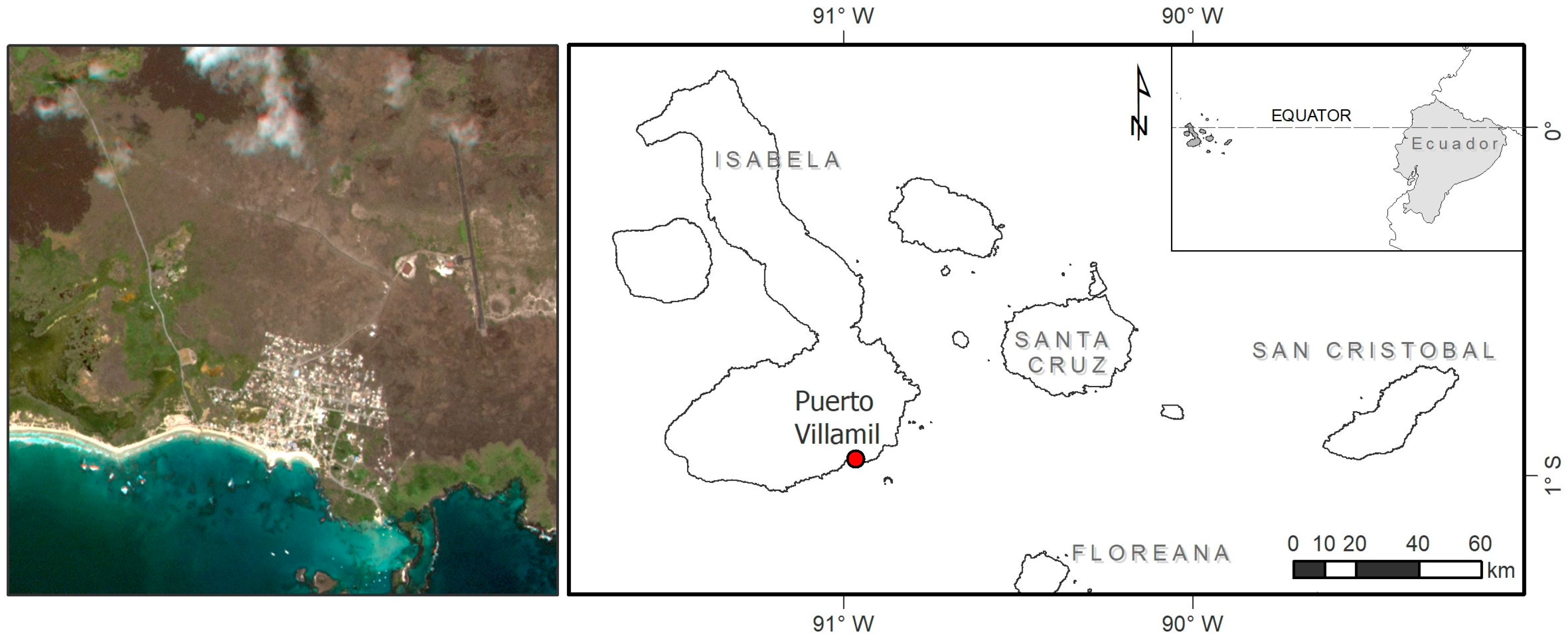
2.1. Study Area and Datasets
2.2. Methodology
2.2.1. The Spectral Mixture Analysis (SMA)
2.2.2. The Object-Based Classification Using Spectral Indices
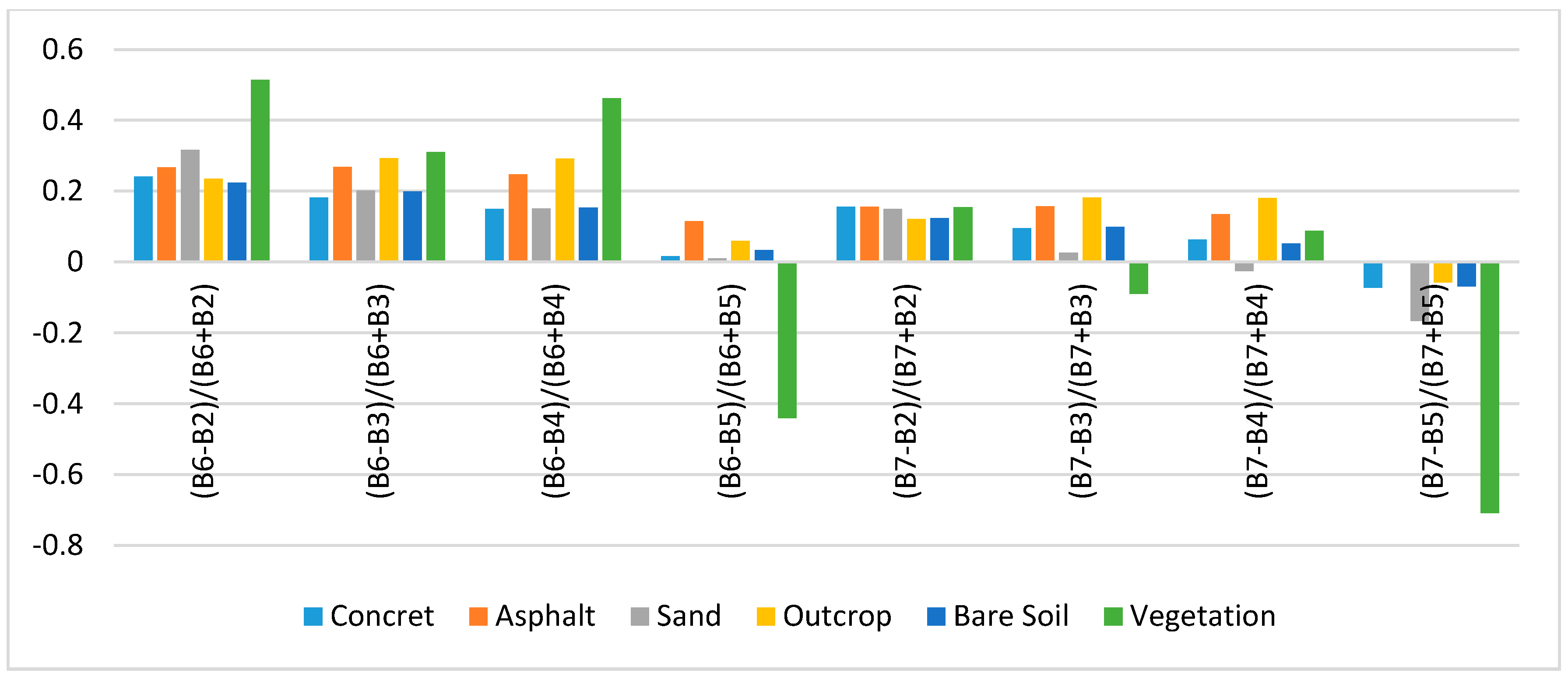
Calculating Anthropogenic Impervious Surface Index
Extraction of Impervious Surface through an Object-Based Classification
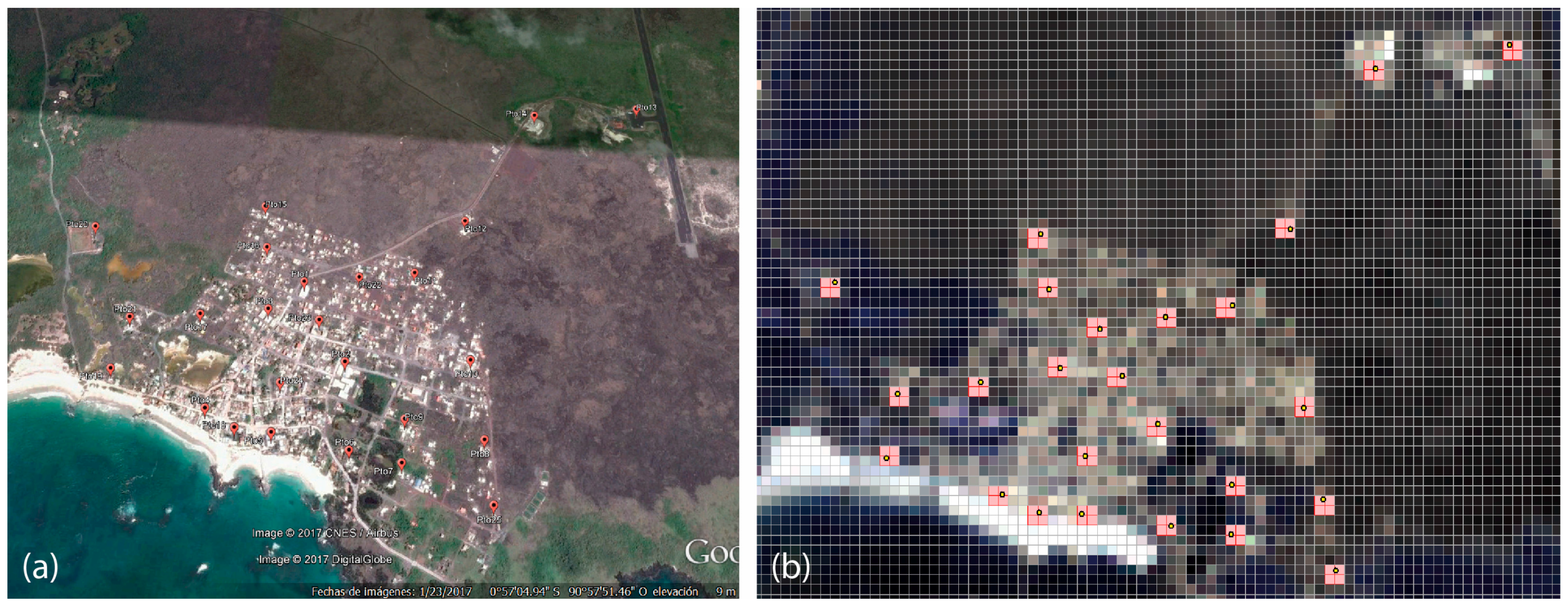
2.2.3. Accuracy Assessment
3. Results
3.1. Methods Analysis
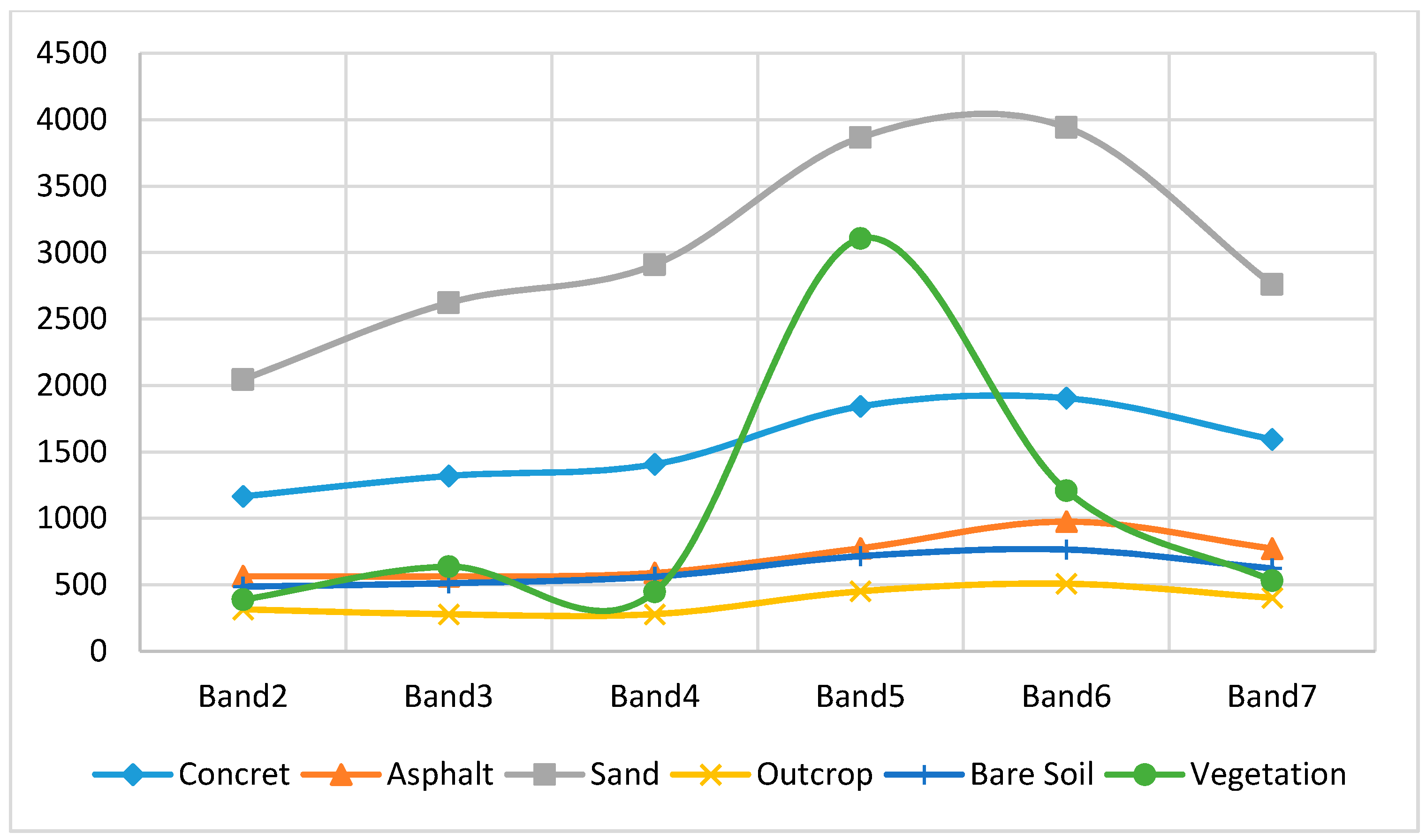
3.1.1. Spectral Mixture Analysis
3.1.2. Object-Based Classification
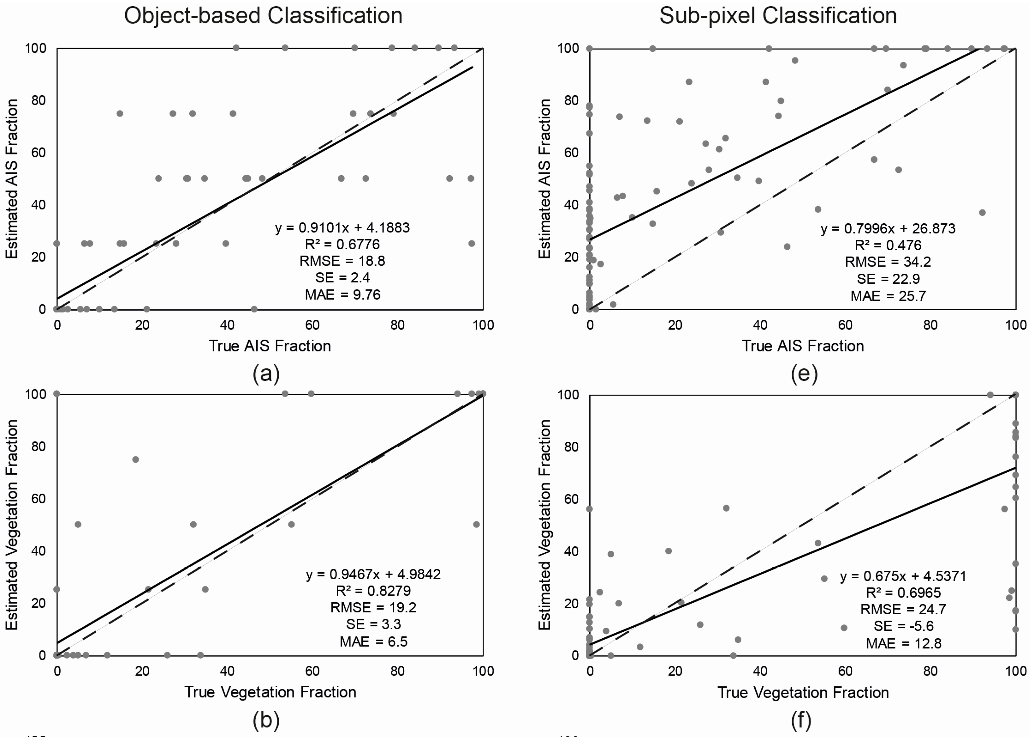
3.1.3. Accuracy Assessment
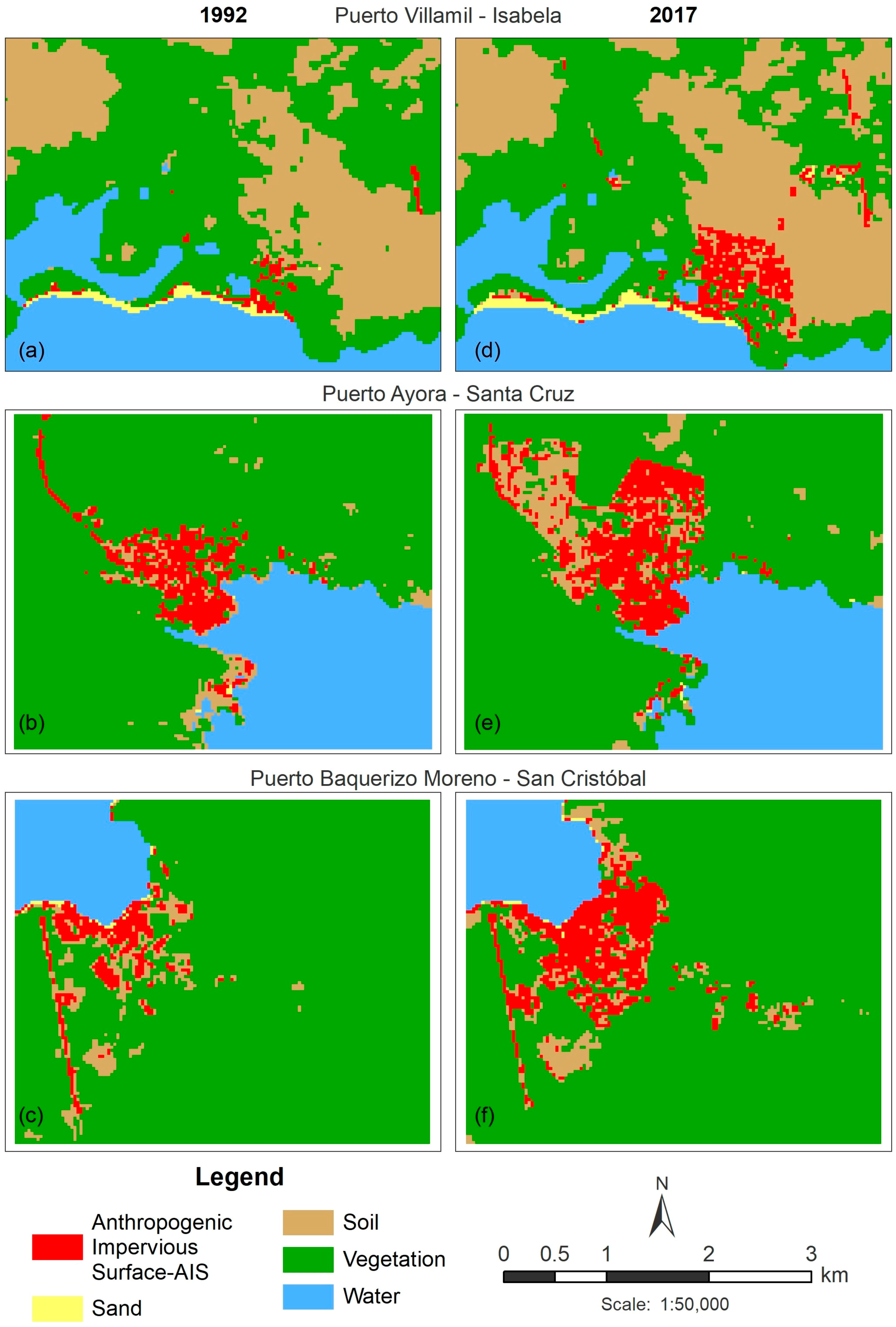
3.2. Land Cover Change between 1992 and 2017
3.3. Impervious Surface Growth and Sprawl
4. Discussion
4.1. Classifier Approach
4.2. Urban Growth
5. Conclusions
Acknowledgments
Author Contributions
Conflicts of Interest
References
- Poumanyvong, P.; Kaneko, S. Does urbanization lead to less energy use and lower CO2 emissions? A cross-country analysis. Ecol. Econ. 2010, 70, 434–444. [Google Scholar] [CrossRef]
- ME (Ministerio de Economía). Primer Censo de Población del Ecuador 1950; Dirección General de Estadísticas y Censos: Quito, Ecuador, 1960.
- Dams, J.; Dujardin, J.; Reggers, R.; Bashir, I.; Canters, F.; Batelaan, O. Mapping impervious surface change from remote sensing for hydrological modeling. J. Hydrol. 2013, 485, 84–95. [Google Scholar] [CrossRef]
- Yang, J.; He, Y. Automated mapping of impervious surfaces in urban and suburban areas: Linear spectral unmixing of high spatial resolution imagery. Int. J. Appl. Earth Obs. Geoinf. 2017, 54, 53–64. [Google Scholar] [CrossRef]
- Wang, J.; Huang, B.; Fu, D.; Atkinson, P.M. Spatiotemporal variation in surface urban heat island intensity and associated determinants across major Chinese cities. Remote Sens. 2015, 7, 3670–3689. [Google Scholar] [CrossRef]
- El Garouani, A.; Mulla, D.J.; El Garouani, S.; Knight, J. Analysis of urban growth and sprawl from remote sensing data: Case of Fez, Morocco. Int. J. Sustain. Built Environ. 2017, 6, 160–169. [Google Scholar] [CrossRef]
- Cocklin, C.; Keen, M. Urbanization in the Pacific: Environmental change, vulnerability and human security. Environ. Conserv. 2000, 27, 392–403. [Google Scholar] [CrossRef]
- Garg, A.; Pal, D.; Singh, H. A comparative study of NDBI, NDISI and NDII for extraction of urban impervious surface of Dehradun [Uttarakhand, India] using Landsat 8 imagery. In Proceedings of the 2016 International Conference on Emerging Trends in Communication Technologies (ETCT), Dehradun, India, 18–19 November 2016; pp. 1–5. [Google Scholar]
- Cablk, M.; Minor, T. Detecting and discriminating impervious cover with high-resolution IKONOS data using principal component analysis and morphological operators. Int. J. Remote Sens. 2003, 24, 4627–4645. [Google Scholar] [CrossRef]
- Yang, J.; Li, P. Impervious surface extraction in urban areas from high spatial resolution imagery using linear spectral unmixing. Remote Sens. Appl. Soc. Environ. 2015, 1, 61–71. [Google Scholar] [CrossRef]
- Momeni, R.; Aplin, P.; Boyd, D.S. Mapping complex urban land cover from spaceborne imagery: The influence of spatial resolution, spectral band set and classification approach. Remote Sens. 2016, 8, 88. [Google Scholar] [CrossRef]
- Deng, C.; Wu, C. A spatially adaptive spectral mixture analysis for mapping subpixel urban impervious surface distribution. Remote Sens. Environ. 2013, 133, 62–70. [Google Scholar] [CrossRef]
- Kant, A.; Kumar, S. Semi-automatic mapping of anthropogenic impervious surfaces in an urban_suburban area using Landsat 8 satellite data. GISci. Remote Sens. 2017, 54, 471–494. [Google Scholar]
- Kuang, W.; Liu, J.; Zhang, Z.; Lu, D.; Xiang, B. Spatiotemporal dynamics of impervious surface areas across China during the early 21st century. Chin. Sci. Bull. 2012, 58, 1691–1701. [Google Scholar] [CrossRef]
- Lu, D.; Moran, E.; Hetrick, S. Detection of impervious surface change with multitemporal Landsat images in an urban-rural frontier. ISPRS J. Photogramm. Remote Sens. 2011, 66, 298–306. [Google Scholar] [CrossRef] [PubMed]
- Poursanidis, D.; Chrysoulakis, N.; Mitraka, Z. Landsat 8 vs. Landsat 5: A comparison based on urban and peri-urban land cover mapping. Int. J. Appl. Earth Obs. Geoinf. 2015, 35, 259–269. [Google Scholar] [CrossRef]
- Yuan, F.; Wu, C.; Bauer, M.E. Comparison of spectral analysis techniques for impervious surface estimation using Landsat imagery. Photogramm. Eng. Remote Sens. 2008, 74, 1045–1055. [Google Scholar] [CrossRef]
- Wu, C.; Murray, A.T. Estimating impervious surface distribution by spectral mixture analysis. Remote Sens. Environ. 2003, 84, 493–505. [Google Scholar] [CrossRef]
- Zhang, Y.; Balzter, H.; Liu, B.; Chen, Y. Analyzing the impacts of urbanization and seasonal variation on land surface temperature based on subpixel fractional covers using Landsat images. IEEE J. Sel. Top. Appl. Earth Obs. Remote Sens. 2017, 10, 1344–1356. [Google Scholar] [CrossRef]
- Powell, R.L.; Roberts, D.A.; Dennison, P.E.; Hess, L.L. Sub-pixel mapping of urban land cover using multiple endmember spectral mixture analysis: Manaus, Brazil. Remote Sens. Environ. 2007, 106, 253–267. [Google Scholar] [CrossRef]
- Tran, T.; Julian, J.; de Beurs, K. Land cover heterogeneity effects on sub-pixel and per-pixel classifications. ISPRS Int. J. Geo-Inf. 2014, 3, 540–553. [Google Scholar] [CrossRef]
- Yuan, F.; Bauer, M.E. Mapping impervious surface area using high resolution imagery: A comparison of object-based and per pixel classification. In Proceedings of the ASPRS 2006 Annual Conference, Reno, NV, USA, 1–5 May 2006; pp. 1667–1674. [Google Scholar]
- Zhou, Y.; Wang, Y. Extraction of impervious surface areas from high spatial resolution imagery by multiple agent segmentation and classification. Photogramm. Eng. Remote Sens. 2008, 74, 857–868. [Google Scholar] [CrossRef]
- Myint, S.W.; Mesev, V.; Quattrochi, D.; Wentz, E.A. Urban image classification: Per-pixel classifiers, sub-pixel analysis, object-based image analysis, and geospatial methods. In Urban Remote Sensing: Evolution, History, Current State-of-Art, and Future Vision; NASA: Washington, DC, USA; Taylor & Francis: Huntsville, AL, USA, 2013. [Google Scholar]
- INEC (Instituto Nacional de Estadísticas y Censos). Censo de Población y Vivienda Galápagos; Publicaciones INEC: Quito, Ecuador, 2015.
- INEC (Instituto Nacional de Estadísticas y Censos). V Censo de Población y IV de Vivienda 1990; Publicaciones INEC: Quito, Ecuador, 1990.
- GCT (Galapagos Conservation Trust). Available online: http://galapagosconservation.org.uk (accessed on 15 August 2017).
- Collins, A.; Bush, M.B. An analysis of modern pollen representation and climatic conditions on the Galapagos Islands. Holocene 2011, 21, 237–250. [Google Scholar] [CrossRef]
- Deng, C.; Wu, C. BCI: A biophysical composition index for remote sensing of urban environments. Remote Sens. Environ. 2012, 127, 247–259. [Google Scholar] [CrossRef]
- Zhou, Y.; Yang, G.; Wang, S.; Wang, L.; Wang, F.; Liu, X. A new index for mapping built-up and bare land areas from Landsat-8 OLI data. Remote Sens. Lett. 2014, 5, 862–871. [Google Scholar] [CrossRef]
- Al Fugara, A.M.; Pradhan, B.; Mohamed, T.A. Improvement of land-use classification using object-oriented and fuzzy logic approach. Appl. Geomat. 2009, 1, 111–120. [Google Scholar] [CrossRef]
- Yan, G. Pixel Based and Object Oriented Image Analysis for Coal Fire Research. Master’s Thesis, International Institute for Geo-Information Science and Earth Observation, Enshede, The Netherlands, 2003. [Google Scholar]
- Phinn, S.; Stanford, M.; Scarth, P.; Murray, A.T.; Shyy, P.T. Monitoring the composition of urban environments based on the vegetation-impervious surface-soil (VIS) model by subpixel analysis techniques. Int. J. Remote Sens. 2002, 23, 4131–4153. [Google Scholar] [CrossRef]
- Wu, C. Normalized spectral mixture analysis for monitoring urban composition using ETM+ imagery. Remote Sens. Environ. 2004, 93, 480–492. [Google Scholar] [CrossRef]
- Lu, D.; Moran, E.; Batistella, M. Linear mixture model applied to Amazonian vegetation classification. Remote Sens. Environ. 2003, 87, 456–469. [Google Scholar] [CrossRef] [Green Version]
- Pu, R.; Gong, P.; Michishita, R.; Sasagawa, T. Spectral mixture analysis for mapping abundance of urban surface components from the Terra/ASTER Data. Remote Sens. Environ. 2008, 112, 939–954. [Google Scholar] [CrossRef]
- Tompkins, S.; Mustard, J.F.; Pieters, C.M.; Forsyth, D.W. Optimization of endmembers for spectral mixture analysis. Remote Sens. Environ. 1997, 59, 472–489. [Google Scholar] [CrossRef]
- Ridd, M.K. Exploring a V–I–S (vegetation–impervious surface–soil) model for urban ecosystem analysis through remote sensing: Comparative anatomy for cities. Int. J. Remote Sens. 1995, 16, 2165–2185. [Google Scholar] [CrossRef]
- Boardman, J.W.; Kruse, F.A. Automated spectral analysis: A geological example using AVIRIS data, north Grapevine Mountains, Nevada. In Proceedings of the ERIM Tenth Thematic Conference on Geologic Remote Sensing, Environmental Research Institute of Michigan, Ann Arbor, MI, USA, 9–12 May 1994; pp. 407–418. [Google Scholar]
- Boardman, J.W.; Kruse, F.A.; Green, R.O. Mapping target signatures via partial unmixing of AVIRIS data. In Proceedings of the Summaries of the 5th Airborne Earth Science Workshop, Pasadena, CA, USA, 23–26 January 1995; Volume 95, pp. 23–26. [Google Scholar]
- Sakti, A.D.; Tsuyuki, S. Spectral mixture analysis (SMA) of Landsat imagery for land cover study of highly degraded peatland in Indonesia. Int. Arch. Photogramm. Remote Sens. Spat. Inf. Sci. ISPRS Arch. 2015, 40, 495–501. [Google Scholar] [CrossRef]
- Trimble. eCognition Developer 8.7: User Guide; Trimble Germany Gmbh: Eschborn, Germany, 2011. [Google Scholar]
- Wong, T.H.; Mansor, S.B.; Mispan, M.R.; Ahmad, N.; Sulaiman, W.N.A. Feature extraction based on object oriented analysis. In Proceedings of the ATC 2003 Conference, San Antonio, TX, USA, 9–14 June 2003; pp. 1–10. [Google Scholar]
- Rouse, J.W.; Hass, R.H.; Schell, J.A.; Deering, D.W. Monitoring vegetation systems in the Great Plains with ERTS. In Proceedings of the ERTS SYMPOSIUM, Washington, DC, USA, 10–14 December 1973; pp. 309–317. [Google Scholar]
- Tucker, C.J. Red and photographic infrared linear combinations for monitoring vegetation. Remote Sens. Environ. 1979, 8, 127–150. [Google Scholar] [CrossRef]
- Shen, Y.; Shen, H.; Li, H.; Cheng, Q. Long-term urban impervious surface monitoring using spectral mixture analysis: A case study of Wuhan city in China. In Proceedings of the 2016 IEEE International Geoscience and Remote Sensing Symposium (IGARSS), Beijing, China, 10–15 July 2016; pp. 6754–6757. [Google Scholar]
- Yuan, F.; Sawaya, K.E.; Loeffelholz, B.C.; Bauer, M.E. Land cover classification and change analysis of the Twin Cities (Minnesota) metropolitan area by multitemporal Landsat remote sensing. Remote Sens. Environ. 2005, 98, 317–328. [Google Scholar] [CrossRef]
- OECD. OECD Regions at a Glance; OECD Publishing: Paris, France, 2013. [Google Scholar]
- Foody, G.M. Status of land cover classification accuracy assessment. Remote Sens. Environ. 2002, 80, 185–201. [Google Scholar] [CrossRef]
- Walsh, S.J.; Mena, C.F. Coupled human-natural systems: Interactions of social, terrestrial & marine sub-systems in the Galapagos Islands. Proc. Natl. Acad. Sci. USA 2016, 113, 14536–14543. [Google Scholar] [PubMed]
- Zylberberg, M.; Lee, K.A.; Klasing, K.C.; Wikelski, M. Variation with land use of immune function and prevalence of avian pox in Galapagos finches. Conserv. Biol. 2013, 27, 103–112. [Google Scholar] [CrossRef] [PubMed]
- de la Torre, S. Research in agricultural and urban areas in Galapagos: A biological perspective. In Science and Conservation in the Galapagos Islands; Walsh, S.J., Mena, C.F., Eds.; Springer: New York, NY, USA, 2013; pp. 185–198. [Google Scholar]
- Walsh, S.J.; McCleary, A.L.; Heumann, B.W.; Brewington, L.; Raczkowski, E.J.; Mena, C.F. Community expansion and infrastructure development: Implications for human health and environmental quality in the Galápagos Islands of Ecuador. J. Lat. Am. Geogr. 2010, 9, 137–159. [Google Scholar] [CrossRef]
- Ragazzi, M.; Catellani, R.; Rada, E.C.; Torretta, V.; Salazar-Valenzuela, X. Management of urban wastewater on one of the Galapagos Islands. Sustainability 2016, 8, 208. [Google Scholar] [CrossRef]
- Denkinger, J.; Quiroga, D.; Murillo, J.C. Assessing human–wildlife conflicts and benefits of Galápagos sea lions on San Cristobal Island, Galápagos. In The Galapagos Marine Reserve: A Dynamic Social-Ecological System; Denkinger, J., Vinueza, L., Eds.; Springer: New York, NY, USA, 2014; pp. 285–305. [Google Scholar]
- Reyes, M.F.; Trifunović, N.; Sharma, S.; Kennedy, M. Data assessment for water demand and supply balance on the island of Santa Cruz (Galápagos Islands). Desalin. Water Treat. 2016, 57, 21335–21349. [Google Scholar] [CrossRef]
- Toral-Granda, M.V.; Causton, C.E.; Jäger, H.; Trueman, M.; Izurieta, J.C.; Araujo, E.; Cruz, M.; Zander, K.K.; Izurieta, A.; Garnett, S.T. Alien species pathways to the Galapagos Islands, Ecuador. PLoS ONE 2017, 12, e0184379. [Google Scholar] [CrossRef] [PubMed]
- Pizzitutti, F.; Walsh, S.J.; Rindfuss, R.R.; Gunter, R.; Quiroga, D.; Tippett, R.; Mena, C.F. Scenario planning for tourism management: A participatory and system dynamics model applied to the Galapagos Islands of Ecuador. J. Sustain. Tour. 2017, 25, 1117–1137. [Google Scholar] [CrossRef]
- Zhang, B.; Xie, G.; Zhang, C.; Zhang, J. The economic benefits of rainwater-runoff reduction by urban green spaces: A case study in Beijing, China. J. Environ. Manag. 2012, 100, 65–71. [Google Scholar] [CrossRef] [PubMed]
- Jenerette, G.D.; Harlan, S.L.; Stefanov, W.L.; Martin, C.A. Ecosystem services and urban heat riskscape moderation: Water, green spaces, and social inequality in Phoenix, USA. Ecol. Appl. 2011, 21, 2637–2651. [Google Scholar] [CrossRef] [PubMed]
- Young, R.F. Managing municipal green space for ecosystem services. Urban For. Urban Green. 2010, 9, 313–321. [Google Scholar] [CrossRef]


| Sensor | Level | Path/Row | Acquisition Date | Urban Center |
|---|---|---|---|---|
| OLI | 1TP | 18/61 | 15-January-2017 | Puerto Villamil |
| TM | 1TP | 18/61 | 18-March-1993 | Puerto Villamil |
| OLI | 1TP | 17/61 | 30-April-2017 | Puerto Baquerizo Moreno |
| TM | 1GS | 17/61 | 17-May-1994 | Puerto Baquerizo Moreno |
| OLI | 1TP | 18/60 | 4-March-2017 | Puerto Ayora |
| TM | 1TP | 18/60 | 14-April-1991 | Puerto Ayora |
| Index | Equation |
|---|---|
| Normalized Difference Vegetation Index | |
| Normalized Green-Red Difference Vegetation Index | |
| Biophysical Composition Index | where: = normalized TC1 = normalized TC3 = normalized TC2 |
| Modified Normalized Difference Soil Index for Islands | |
| Normalized Difference Anthropogenic Impervious Surface Index | where: |
| Puerto Ayora | Puerto Baquerizo Moreno | Puerto Villamil | TOTAL | |||||||||
|---|---|---|---|---|---|---|---|---|---|---|---|---|
| 1991 | 2017 | Change | 1994 | 2017 | Change | 1993 | 2017 | Change | ~1992 | 2017 | Change | |
| IS | 72.5 | 127.5 | 55.0 | 46.5 | 113.2 | 66.7 | 14.9 | 63.6 | 48.7 | 134.0 | 304.4 | 170.4 |
| Soil | 46.4 | 100.7 | 54.3 | 57.2 | 68.8 | 11.5 | 811.8 | 923.5 | 111.7 | 915.5 | 1093.0 | 177.5 |
| Vegetation | 891.7 | 782.2 | −109.5 | 1126.3 | 1048.9 | −77.4 | 1181.9 | 1020.4 | −161.5 | 3199.9 | 2851.5 | −348.4 |
| Sand | 0.7 | 1.0 | 0.3 | 3.2 | 2.3 | −0.8 | 18.2 | 19.3 | 1.1 | 22.1 | 22.6 | 0.5 |
| TOTAL | 1011.4 | 1011.4 | 1233.2 | 1233.2 | 2026.8 | 2026.8 | 4271.4 | 4271.4 | ||||
| IS | Soil | Vegetation | Sand | 2017 Total | |
|---|---|---|---|---|---|
| IS | 93.29 | 66.19 | 141.10 | 3.78 | 304.4 |
| Soil | 23.77 | 776.27 | 292.57 | 0.36 | 1093.0 |
| Vegetation | 14.22 | 72.39 | 2763.34 | 1.53 | 2851.5 |
| Sand | 2.70 | 0.63 | 2.88 | 16.38 | 22.6 |
| 1992 Total | 134.0 | 915.5 | 3199.9 | 22.1 | 4271.4 |
| Census Data | |||||||
| Urban Centers | 1990 | 2001 | 2006 | 2010 | 2015 | 2015–1990 | Annual Growth Rate (%) |
| Puerto Ayora | 4294 | 9582 | 9208 | 11,974 | 11,822 | 7528 | 4.1 |
| Puerto Baquerizo Moreno | 3023 | 4908 | 5539 | 6672 | 6553 | 3530 | 3.1 |
| Puerto Villamil | 696 | 1420 | 1570 | 2092 | 2164 | 1468 | 4.6 |
| TOTAL | 8013 | 15,910 | 16,317 | 20,738 | 20,539 | 12,526 | 3.8 |
| Landsat Classification | |||||||
| Urban Centers | 1991 | 1993 | 1994 | ~1992 | 2017 | 2017–(~1992) | Annual Growth Rate (%) |
| Puerto Ayora | 72.63 | -- | -- | -- | 127.53 | 54.99 | 2.2 |
| Puerto Baquerizo Moreno | -- | -- | 46.51 | -- | 113.20 | 66.70 | 3.5 |
| Puerto Villamil | -- | 14.94 | -- | -- | 63.63 | 48.69 | 5.7 |
| TOTAL | 133.99 | 304.36 | 170.38 | 3.3 | |||
| Urban Centers | USI | PD |
|---|---|---|
| Puerto Ayora | −1.0 | 1.9 |
| Puerto Baquerizo Moreno | 0.3 | 0.9 |
| Puerto Villamil | 1.1 | 0.8 |
© 2018 by the authors. Licensee MDPI, Basel, Switzerland. This article is an open access article distributed under the terms and conditions of the Creative Commons Attribution (CC BY) license (http://creativecommons.org/licenses/by/4.0/).
Share and Cite
Benítez, F.L.; Mena, C.F.; Zurita-Arthos, L. Urban Land Cover Change in Ecologically Fragile Environments: The Case of the Galapagos Islands. Land 2018, 7, 21. https://doi.org/10.3390/land7010021
Benítez FL, Mena CF, Zurita-Arthos L. Urban Land Cover Change in Ecologically Fragile Environments: The Case of the Galapagos Islands. Land. 2018; 7(1):21. https://doi.org/10.3390/land7010021
Chicago/Turabian StyleBenítez, Fátima L., Carlos F. Mena, and Leo Zurita-Arthos. 2018. "Urban Land Cover Change in Ecologically Fragile Environments: The Case of the Galapagos Islands" Land 7, no. 1: 21. https://doi.org/10.3390/land7010021
APA StyleBenítez, F. L., Mena, C. F., & Zurita-Arthos, L. (2018). Urban Land Cover Change in Ecologically Fragile Environments: The Case of the Galapagos Islands. Land, 7(1), 21. https://doi.org/10.3390/land7010021