Quantifying the Spatiotemporal Pattern of Urban Expansion and Hazard and Risk Area Identification in the Kaski District of Nepal


Abstract
:1. Introduction
2. Materials and Methods
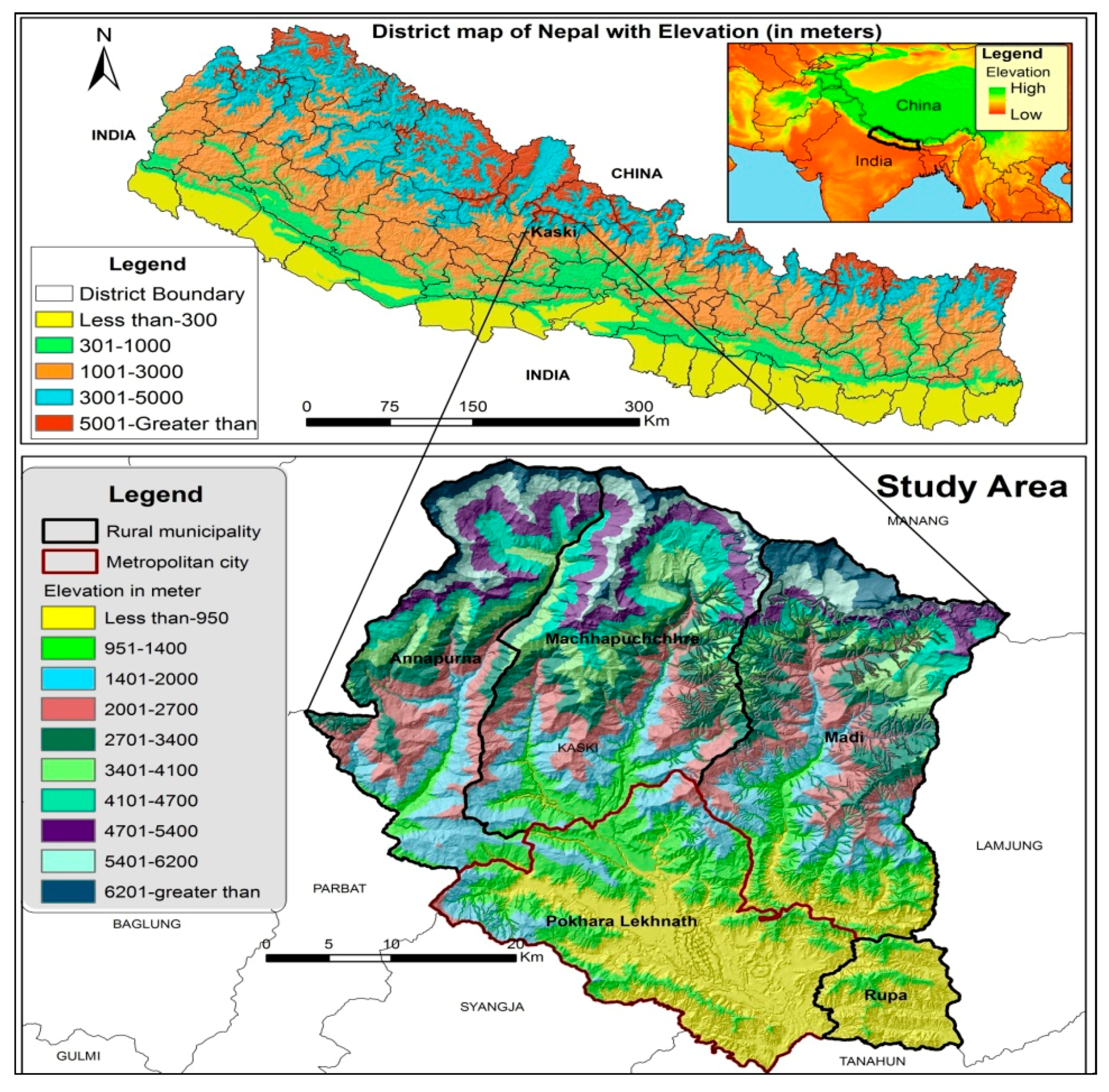
2.1. Study Area
2.2. Data
2.3. Image Processing and Analysis
2.4. LULC Extraction, and Analysis
2.5. LULC Based Transition Analysis
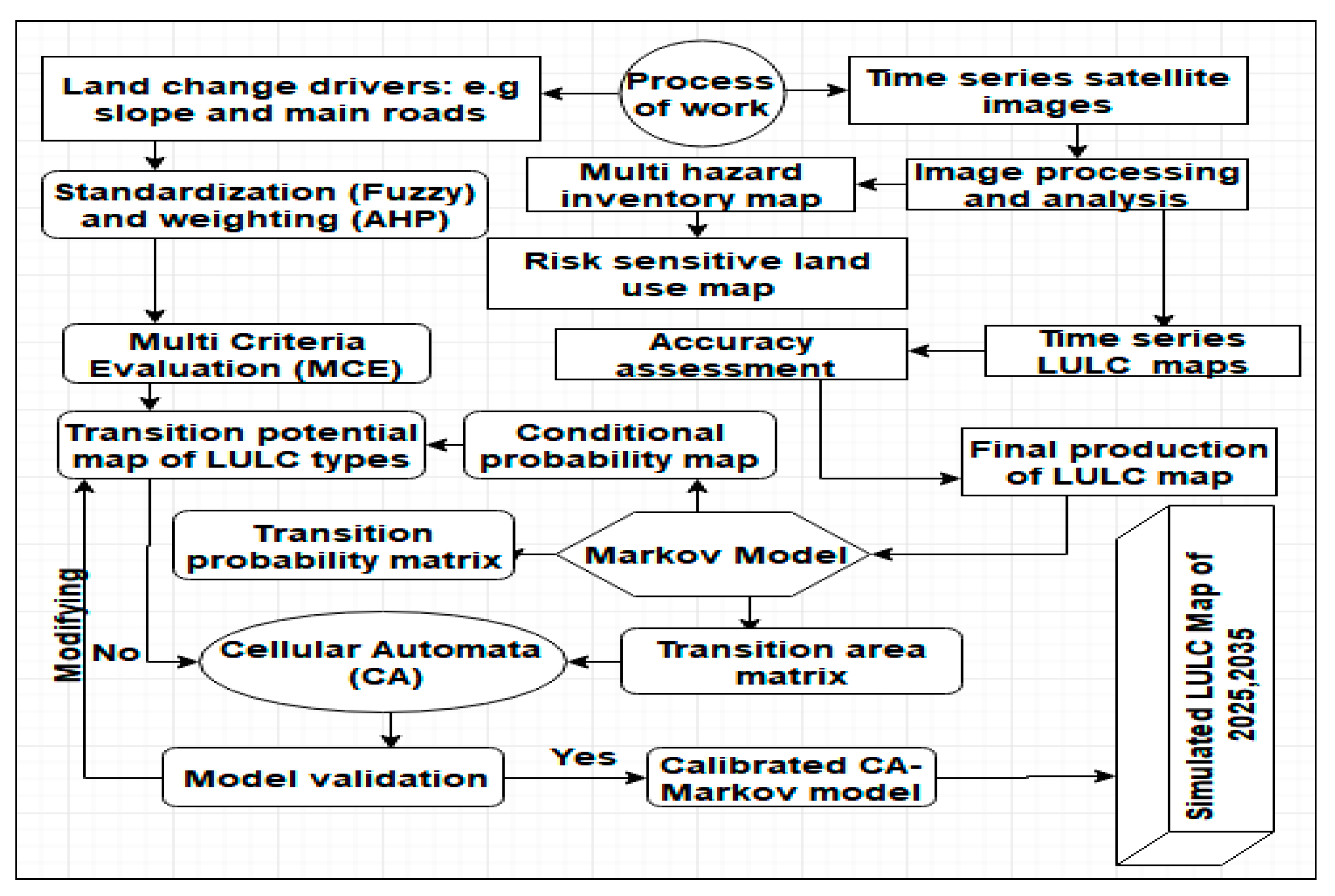
2.6. Identification of Multihazard and Risk Analysis
2.7. The CA-Markov Model
2.8. Evaluation of Land-Cover Modeling
2.9. Accuracy Accessment
3. Results
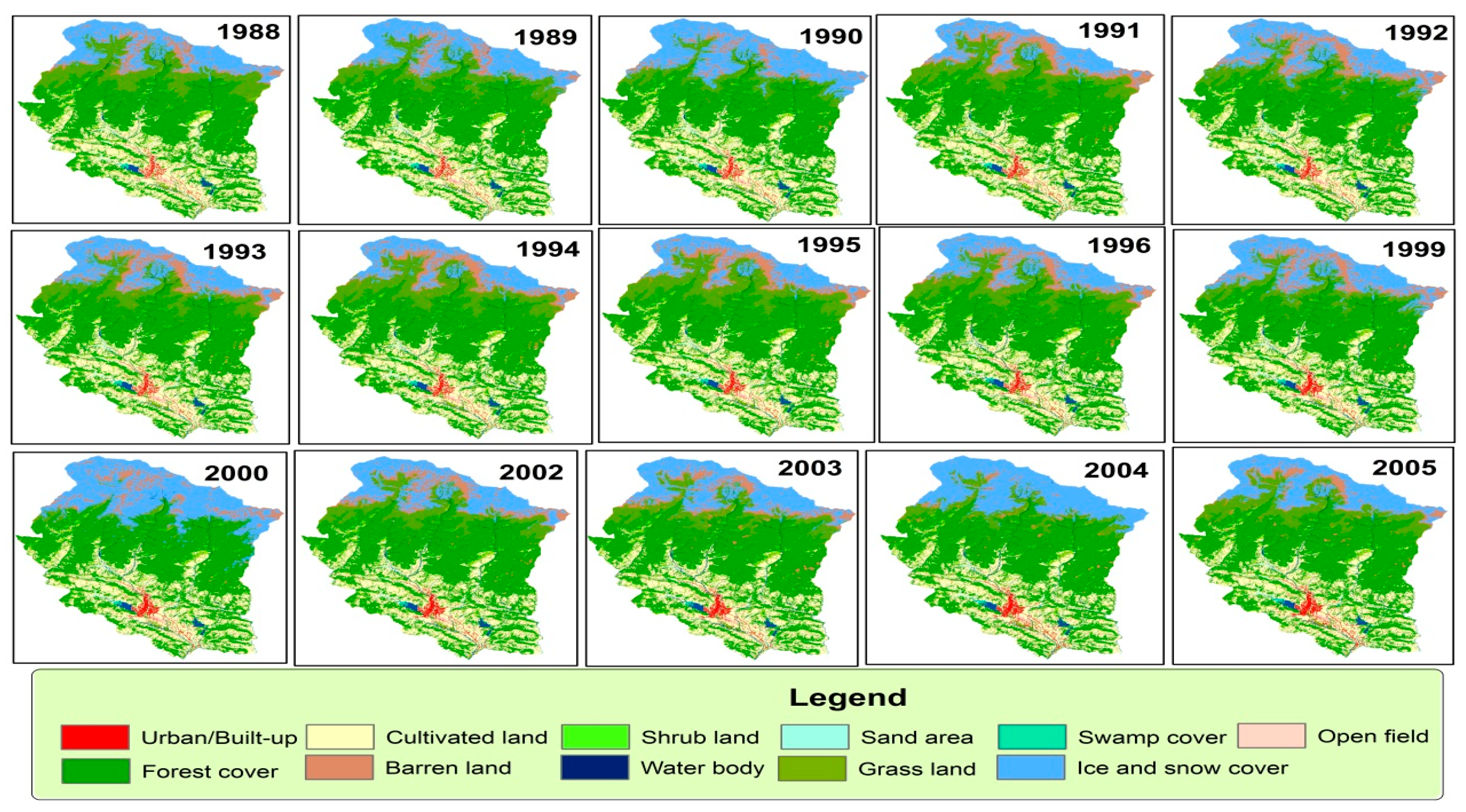
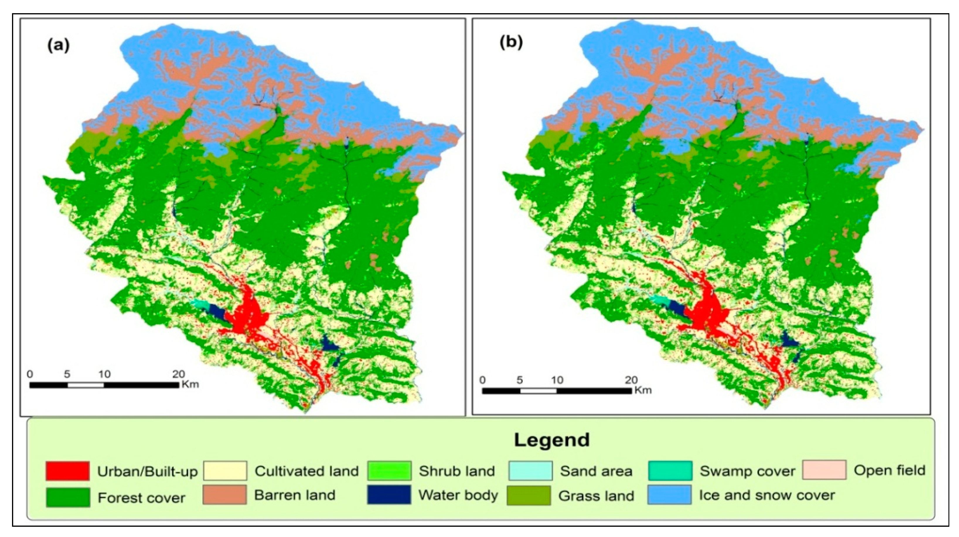
3.1. LULC Change Analysis of 1988–2016
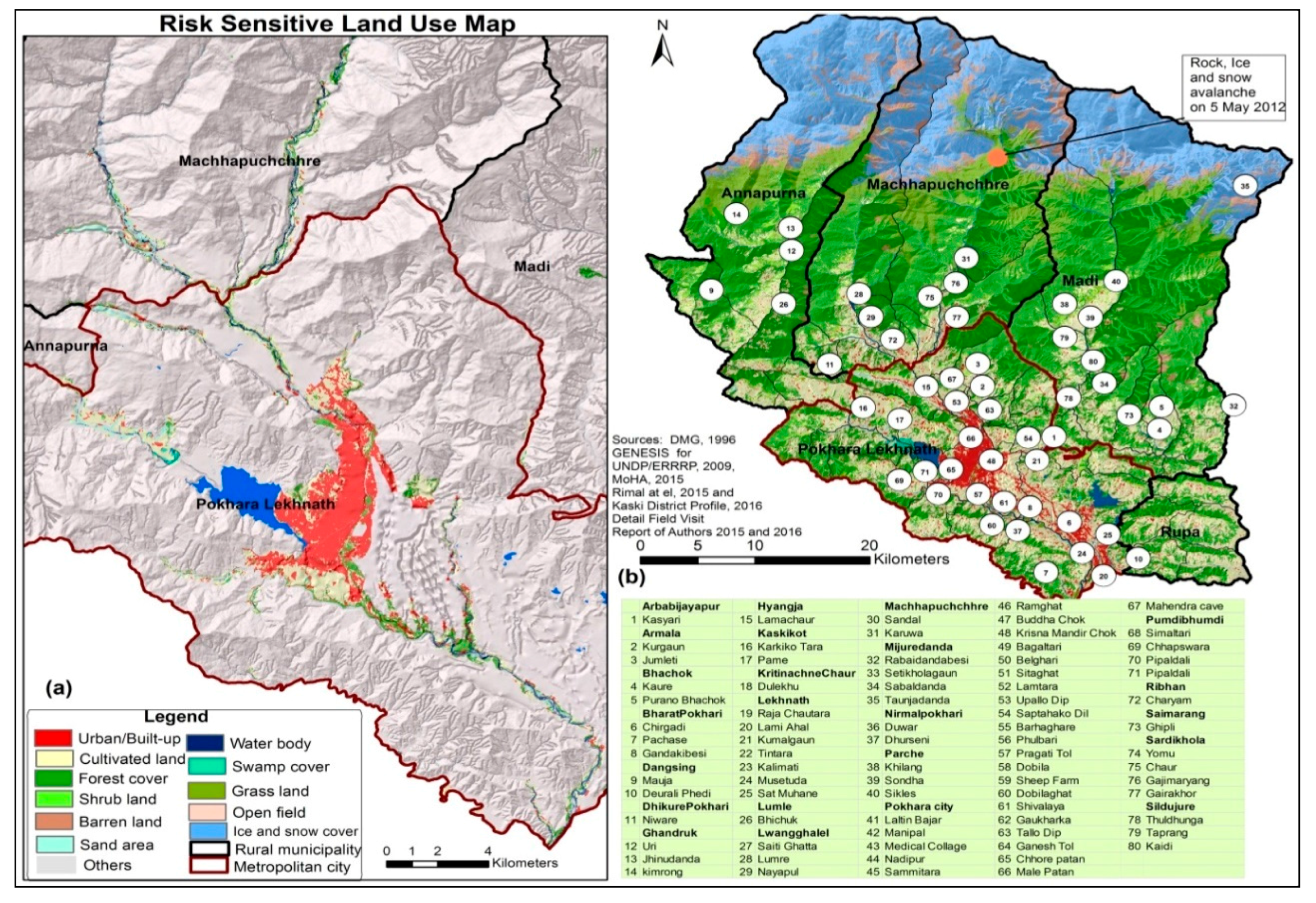
3.2. Multihazard Risk
3.2.1. Flood Hazard
3.2.2. Edge Fall and Landslides
3.2.3. Land Subsidence and Sinkhole
3.3. Modeling and Validation of Land-Use Change from 2015 and Onwards
4. Discussion
5. Conclusions and Recommendations
Supplementary Materials
Acknowledgments
Author Contributions
Conflict of Interest
References
- Ellis, E. Landuse and landcover change and climate change. In Landuse and Landcover Change Encyclopedia of Earth; Cutler, J.C., Ed.; Environmental Information Coalition, National Council for Science and the Environment: Washington, DC, USA, 2007. [Google Scholar]
- Khanal, N.R. Land Use and Land Cover Dynamics in the Himalayan: A Case Study of the Madi Watershed, Western Development Region, Nepal (2002). Ph.D. Thesis, Tribhuvan University, Kathmandu, Nepal, 2002. [Google Scholar]
- Álvarez-Berríos, N.; Redo, D.; Aide, T.; Clark, M.; Grau, R. Land change in the greater antilles between 2001 and 2010. Land 2013, 2, 81–107. [Google Scholar] [CrossRef]
- Sharma, P. Urbanization and development. In Population Monograph of Nepal; Statistics, C.B.O., Ed.; Central Bureau of Statistics: Kathmandu, Nepal, 2003; Volume 1, pp. 375–412. [Google Scholar]
- Hedblom, M.; Andersson, E.; Borgström, S. Flexible land-use and undefined governance: From threats to potentials in peri-urban landscape planning. Land Use Policy 2017, 63, 523–527. [Google Scholar] [CrossRef]
- United Nations International Strategy for Disaster Reduction (UNISDR). Living with Risk. A Global Review of Disasterreduction Initiatives; United Nations, Inter-Agency Secretariat of the International Strategy for Disaster Reduction: New York, NY, USA; Geneva, Switzerland, 2004; Volume 1. [Google Scholar]
- Batuk, F.Ş.B.; Emem, O. Relations between disaster management, urban planning and NSDI. Int. Arch. Photogramm. Remote Sens. Spat. Inf. Sci. 2008, 37, 441–444. [Google Scholar]
- Rimal, B.; Baral, H.; Stork, N.; Paudyal, K.; Rijal, S. Growing city and rapid land use transition: Assessing multiple hazards and risks in the pokhara valley, nepal. Land 2015, 4, 957–978. [Google Scholar] [CrossRef]
- Kwak, Y.-J. Nationwide flood monitoring for disaster risk reduction using multiple satellite data. ISPRS Int. J. Geo-Inf. 2017, 6, 203. [Google Scholar] [CrossRef]
- Ban, H.-J.; Kwon, Y.-J.; Shin, H.; Ryu, H.-S.; Hong, S. Flood monitoring using satellite-based rgb composite imagery and refractive index retrieval in visible and near-infrared bands. Remote Sens. 2017, 9, 313. [Google Scholar] [CrossRef]
- Li, S.; Cui, Y.; Liu, M.; He, H.; Ravan, S. Integrating global open geo-information for major disaster assessment: A case study of the myanmar flood. ISPRS Int. J. Geo-Inf. 2017, 6, 201. [Google Scholar] [CrossRef]
- Eskandari, M.; Omidvar, B.; Modiri, M.; Nekooie, M.; Alesheikh, A. Geospatial analysis of earthquake damage probability of water pipelines due to multi-hazard failure. ISPRS Int. J. Geo-Inf. 2017, 6, 169. [Google Scholar] [CrossRef]
- Guha-Sapir, D.; Hoyois, P.; Below, R. Annual Disaster Statistical Review 2015: The Numbers and Trends; Centre for Research on the Epidemiology of Disasters: Brussels, Belgium, 2016. [Google Scholar]
- Mitchell, D.; Grant, D.; Roberge, D.; Bhatta, G.P.; Caceres, C. An evaluation framework for earthquake-responsive land administration. Land Use Policy 2017, 67, 239–252. [Google Scholar] [CrossRef]
- Sanyal, J.; Lu, X.X. Application of remote sensing in flood management with special reference to monsoon asia: A review. Nat. Hazards 2004, 33, 283–301. [Google Scholar] [CrossRef]
- Minister of Home Affairs (MoHA). Nepal Disaster Report 2015; The Government of Nepal, Minister of Home Affairs (MoHA) and Disater Preparedness Network (DPNeT): Kathmandu, Nepal, 2015.
- Sidle, R.C.; Hirotaka, H. Landslides Processes, Prediction, and Land use. In Water Resources Monograph; American Geophysical Union: Washington, DC, USA, 2006; ISBN 13-978-0-87590-322-4. [Google Scholar]
- Guha-Sapir, D.; Hoyois, P.; Below, R. Annual Disaster Statistical Review 2014: The Numbers and Trends; Centre for Research on the Epidemiology of Disasters: Brussels, Belgium, 2015. [Google Scholar]
- Ahmed, B.; Dewan, A. Application of bivariate and multivariate statistical techniques in landslide susceptibility modeling in chittagong city corporation, bangladesh. Remote Sens. 2017, 9, 304. [Google Scholar] [CrossRef]
- Feng, M.; Huang, C.; Channan, S.; Vermote, E.F.; Masek, J.G.; Townshend, J.R. Quality assessment of landsat surface reflectance products using modis data. Comput. Geosci. 2012, 38, 9–22. [Google Scholar] [CrossRef]
- Schneider, A. Monitoring land cover change in urban and peri-urban areas using dense time stacks of landsat satellite data and a data mining approach. Remote Sens. Environ. 2012, 124, 689–704. [Google Scholar] [CrossRef]
- Sexton, J.O.; Song, X.-P.; Huang, C.; Channan, S.; Baker, M.E.; Townshend, J.R. Urban growth of the Washington, DC—Baltimore, MD metropolitan region from 1984 to 2010 by annual, Landsat-based estimates of impervious cover. Remote Sens. Environ. 2013, 129, 42–53. [Google Scholar] [CrossRef]
- Masser, I. Managing our urban future: The role of remote sensing and geographic information systems. Habitat Int. 2001, 25, 503–512. [Google Scholar] [CrossRef]
- Goodchild, M.F. Spatial information for land use management. In Spatial Analysis: Methods and Problems in Land Use Management; Hill, M.J., Aspinall, E.R.J., Eds.; Gordon and Breach Science Publishers: Amsterdam, The Netherlands, 2000; pp. 39–51. [Google Scholar]
- Thapa, R.B.; Murayama, Y. Examining spatiotemporal urbanization patterns in kathmandu valley, Nepal: Remote sensing and spatial metrics approaches. Remote Sens. 2009, 1, 534–556. [Google Scholar] [CrossRef]
- Islam, M.M.; Sado, K. Development of flood hazard maps of bangladesh using noaa-avhrr images with gis. Hydrol. Sci. J. 2000, 45, 337–355. [Google Scholar] [CrossRef]
- Gomes, R.; Guimarães, R.; de Carvalho, O.; Fernandes, N.; do Amaral, E. Combining spatial models for shallow landslides and debris-flows prediction. Remote Sens. 2013, 5, 2219–2237. [Google Scholar] [CrossRef] [Green Version]
- Asare-Kyei, D.; Forkuor, G.; Venus, V. Modeling flood hazard zones at the sub-district level with the rational model integrated with gis and remote sensing approaches. Water 2015, 7, 3531–3564. [Google Scholar] [CrossRef]
- Byun, Y.; Han, Y.; Chae, T. Image fusion-based change detection for flood extent extraction using bi-temporal very high-resolution satellite images. Remote Sens. 2015, 7, 10347–10363. [Google Scholar] [CrossRef]
- Cao, C.; Xu, P.; Wang, Y.; Chen, J.; Zheng, L.; Niu, C. Flash flood hazard susceptibility mapping using frequency ratio and statistical index methods in coalmine subsidence areas. Sustainability 2016, 8, 948. [Google Scholar] [CrossRef]
- Song, C.; Kwan, M.P.; Zhu, J. Modeling fire occurrence at the city scale: A comparison between geographically weighted regression and global linear regression. Int. J. Environ. Res. Public Health 2017, 14, 396. [Google Scholar] [CrossRef] [PubMed]
- Taubenböck, H.; Clodt, S.; Wurm, M.; Wegmann, M.; Jürgens, C. The Capabilities of Remote Sensing to Derive Urban Location Factors for Probability-Based Spatial Growth Analysis. In Proceedings of the International Conferences of Crop Konferenzs, Wien, Austria, 18–20 May 2010; pp. 1–10. [Google Scholar]
- Rodríguez-Maturino, A.; Martínez-Guerrero, J.; Chairez-Hernández, I.; Pereda-Solis, M.; Villarreal-Guerrero, F.; Renteria-Villalobos, M.; Pinedo-Alvarez, A. Mapping land cover and estimating the grassland structure in a priority area of the chihuahuan desert. Land 2017, 6, 70. [Google Scholar] [CrossRef]
- Paudel, B.; Zhang, Y.; Li, S.; Wu, X. Spatiotemporal Reconstruction of Agricultural Land Cover in Nepal from 1970 to 2010. Reg. Environ. Chang. 2017, 17, 2349–2357. [Google Scholar] [CrossRef]
- Rimal, B.; Zhang, L.; Keshtkar, H.; Wang, N.; Lin, Y. Monitoring and modeling of spatiotemporal urban expansion and land-use/land-cover change using integrated markov chain cellular automata model. ISPRS Int. J. Geo-Inf. 2017, 6, 288. [Google Scholar] [CrossRef]
- Haack, B.N.; Rafter, A. Urban growth analysis and modeling in the kathmandu valley, nepal. Habitat Int. 2006, 30, 1056–1065. [Google Scholar] [CrossRef]
- Sleeter, B.M.; Wood, N.J.; Soulard, C.E.; Wilson, T.S. Projecting community changes in hazard exposure to support long-term risk reduction: A case study of tsunami hazards in the U.S. Pacific Northwest. Int. J. Disaster Risk Reduc. 2017, 22, 10–22. [Google Scholar] [CrossRef]
- Sleeter, B.M.; Wilson, T.S.; Sharygin, E.; Sherba, J.T. Future scenarios of land change based on empirical data and demographic trends. Earth Future 2017, 5, 1068–1083. [Google Scholar] [CrossRef]
- Kozak, J.; Gimmi, U.; Houet, T.; Bolliger, J. Current practices and challenges for modelling past and future land use and land cover changes in mountainous regions. Reg. Environ. Chang. 2017, 17, 2187–2191. [Google Scholar] [CrossRef]
- Keshtkar, H.; Voigt, W. A spatiotemporal analysis of landscape change using an integrated markov chain and cellular automata models. Model. Earth Syst. Environ. 2015, 2, 10. [Google Scholar] [CrossRef]
- Allen, J.; Lu, K. Modeling and prediction of future urban growth in the charleston region of south carolina: A gis-based integrated approach. Ecol. Soc. 2003, 8. [Google Scholar] [CrossRef]
- Keshtkar, H.; Voigt, W. Potential impacts of climate and landscape fragmentation changes on plant distributions: Coupling multi-temporal satellite imagery with gis-based cellular automata model. Ecol. Inform. 2016, 32, 145–155. [Google Scholar] [CrossRef]
- Alilou, H.; Moghaddam Nia, A.; Keshtkar, H.; Han, D.; Bray, M. A cost-effective and efficient framework to determine water quality monitoring network locations. Sci. Total Environ. 2018, 624, 283–293. [Google Scholar] [CrossRef] [PubMed]
- Shafizadeh Moghadam, H.; Helbich, M. Spatiotemporal urbanization processes in the megacity of mumbai, india: A markov chains-cellular automata urban growth model. Appl. Geogr. 2013, 40, 140–149. [Google Scholar] [CrossRef]
- Araya, Y.H.; Cabral, P. Analysis and modeling of urban land cover change in setúbal and sesimbra, Portugal. Remote Sens. 2010, 2, 1549–1563. [Google Scholar] [CrossRef]
- Cheng, J. Modelling Spatial and Temporal Urban Growth. Ph.D. Thesis, Utrecht University P.O. Box 80.115 3508 TC Utrecht, Faculty of Geographical Sciences Utrecht University, Utrecht, The Netherlands, 2003. [Google Scholar]
- Aaviksoo, K. Simulating vegetation dynamics and land use in a mire landscape using a markov model. Landsc. Urban Plan. 1995, 31, 129–142. [Google Scholar] [CrossRef]
- Fort, M. The Pokhara Valley: A Product of a Natural Catastrophe. In Geomorphological Landscapes of the World; Springer: Dordrecht, The Netherlands, 2010; pp. 265–274. [Google Scholar]
- Fort, M. Sporadic Morphogenesis in a Continental Subduction Setting: An Example from the Annapurna Range, Nepal Himalaya. Z. Geomorphol. 1987, 63, 36. [Google Scholar]
- Nepal Environmental and Scientific Services (NESS). Feasibility Study on upper Seti (Damauli) Storage Hydroelectric Project for Nepal Electricity Authority (NEA); Nepal Environmental and Scientific Services: Kathmandu, Nepal, 2001. [Google Scholar]
- Dahal, R.K.; Bhandary, N.P. Geo-disaster and its mitigation in nepal. In Progress of Geo-Disaster Mitigation Technology in Asia; Springer: Berlin/Heidelberg, Germany, 2013; pp. 123–156. [Google Scholar]
- Central Bureau of Statistics (CBS). Environment Statistics of Nepal; National Planning Commission Secretariat, Central Bureau of Statistics (CBS): Kathmandu, Nepal, 2011.
- Baral, R. Kaski at high risk of flood and landslip. The Himalayan Times, 20 June 2016. [Google Scholar]
- Pokharel, R.P. Vulnerable land in pokhara city and its use potentiality. Himal. Geogr. 2013, 8, 51–58. [Google Scholar]
- Rijal, M. Characterization of sinkholes affected area of Thulibeshi Phat, Armala, Kaski, Nepal. J. Inst. Sci. Technol. 2017, 22, 17–24. [Google Scholar] [CrossRef]
- Basnet, P.; Balla, M.K.; Pradhan, B.M. Landslide hazard zonation, mapping and investigation of triggering factors in Phewa lake watershed, Nepal. Banko Janakari 2013, 22, 43–52. [Google Scholar] [CrossRef]
- Prashad Bhatt, B.; Datt Awasthi, K.; Prasad Heyojoo, B.; Silwal, T.; Kafle, G. Using geographic information system and analytical hierarchy process in landslide hazard zonation. Appl. Ecol. Environ. Sci. 2013, 1, 14–22. [Google Scholar] [CrossRef]
- GENESIS. Report on Impact of Settlement Pattern, Land Use Practice and Options in High Risk Areas; Pokhara Sub-Metropolitan City; UNDP/ERRRP—Project Nep/07/010; GENESIS: Kathmandu, Nepal, 2009. [Google Scholar]
- Yamanaka, H.; Yoshida, M.; Arita, K. Terrace landforms and quaternary deposits around the pokhara valley. J. Nepal Geol. Soc. 1982, 2, 113–142. [Google Scholar]
- Fort, M.; Adhikari, B.R.; Stolle, A.; Schwanghart, W.; Korop, O. Catastrophic mountain wall collapses in the nepal himalayas: A review, with focus on pokhara valley. In Gradualism vs Catastrophism in Landscape Evolution; International Association of Geomorphologists: Barnaul, Russia, 2015; pp. 15–18. [Google Scholar]
- Kargel, J.S.; Paudel, L.; Leonard, G.; Regmi, D.; Joshi, S.; Poudel, K.; Thapa, B.; Watanabe, T.; Fort, M. Causes and human impacts of the seti river (Nepal) disaster of 2012. In Glacial Flooding & Disaster Risk Management Knowledge Exchange and Field Training; High Mountains Adaptation Partnership: Huaraz, Peru, 2013; pp. 1–11. [Google Scholar]
- The Japanese Disaster Survey Team (JDST). Survey Report on Seti River Flood, Nepal; The Japanese Disaster Survey Team (JDST), Nepal-Japan Friendship Association for Water Induced Disaster Prevention(NFAD): Tokyo, Japan, 2012. [Google Scholar]
- Dickson, E.; Baker, J.L.; Hoornweg, D.; Tiwari, A. Urban Risk Assessments: Understanding Disaster and Climate Risk in Cities; International Bank of Reconstruction and Development, The World Bank: Washington, DC, USA, 2012. [Google Scholar]
- Gigović, L.; Pamučar, D.; Bajić, Z.; Drobnjak, S. Application of gis-interval rough ahp methodology for flood hazard mapping in urban areas. Water 2017, 9, 360. [Google Scholar] [CrossRef]
- Government of Nepal. Stocktaking Report: Land Degradation, National Capacity Self-Assessment for Global Environment Management; Ministry of Environment, Science and Technology: Kathmandu, Nepal, 2008.
- Gurung, H. Pokhara Valley, Nepal Himalaya, a Field Study in Regional Geography. Ph.D. Thesis, University of Edinburgh, Edinburgh, UK, 1965. [Google Scholar]
- Poudel, K.R. Urban growth and land use change in the himalaya region a case study of Pokhara sub-metropolitan city. GIS Ostrav. 2008, 27, 1–11. [Google Scholar]
- Rimal, B. Urban growth and land use/land cover change of Pokhara sub-metropolitan city, Nepal. J. Theor. Appl. Inf. Technol. 2011, 26, 118–129. [Google Scholar]
- District Development Committee (DDC). District Profile; District Development Committee (DDC): Kaski, Nepal, 2015. [Google Scholar]
- Rimal, B. Urban Development and Land Use Change of Main Nepalese Cities. Ph.D. Thesis, University of Wroclaw, Wroclaw, Poland, 2011. [Google Scholar]
- United States Geological Survey (USGS). Earth Explorer, Landsat Data Archive. 2016. Available online: https://earthexplorer.usgs.gov (accessed on 12 March 2018).
- Masek, J.G.; Vermote, E.F.; Saleous, N.E.; Wolfe, R.; Hall, F.G.; Huemmrich, K.F.; Feng, G.; Kutler, J.; Teng-Kui, L. A landsat surface reflectance dataset for North America, 1990–2000. IEEE Geosci. Remote Sens. Lett. 2006, 3, 68–72. [Google Scholar] [CrossRef]
- Vermote, E.; Justice, C.; Claverie, M.; Franch, B. Preliminary analysis of the performance of the landsat 8/oli land surface reflectance product. Remote Sens. Environ. 2016, 185, 46–56. [Google Scholar] [CrossRef]
- GoN. Topographical Map; Government of Nepal, Ministry of Land Resources and Management Survey Department, Topographic Survey Branch: Kathmandu, Nepal, 1998.
- Central Bureau of Statistics (CBS). Population Monograph of Nepal; National Planning Commission Secretariat, Central Bureau of Statistics (CBS): Kathmandu, Nepal, 2014.
- Department of Mines and Geology (DMG). Engineering and Environmental Map of Pokhara Valley; Department of Mines and Geology (DMG): Kathmandu, Nepal, 1996.
- Minister of Home Affairs (MoHA). Nepal Disaster Report. The Government of Nepal, Minister of Home Affairs. Available online: http//drrportal.gov.np (accessed on 19 November 2017).
- Huang, C.; Davis, L.S.; Townshend, J.R.G. An assessment of support vector machines for land cover classification. Int. J. Remote Sens. 2002, 23, 725–749. [Google Scholar] [CrossRef]
- Mubea, K.; Menz, G. Monitoring land-use change in Nakuru (Kenya) using multi-sensor satellite data. Adv. Remote Sens. 2012, 1, 74–84. [Google Scholar] [CrossRef]
- Pal, M.; Mather, P.M. Support vector machines for classification in remote sensing. Int. J. Remote Sens. 2005, 26, 1007–1011. [Google Scholar] [CrossRef]
- Kavzoglu, T.; Colkesen, I. A kernel functions analysis for support vector machines for land cover classification. Int. J. Appl. Earth Observ. Geoinf. 2009, 11, 352–359. [Google Scholar] [CrossRef]
- Pervez, W.; Uddin, V.; Khan, S.A.; Khan, J.A. Satellite-based land use mapping: Comparative analysis of landsat-8, advanced land imager, and big data hyperion imagery. J. Appl. Remote Sens. 2016, 10, 026004. [Google Scholar] [CrossRef]
- Anderson, J.R.; Hardy, E.E.; Roach, J.T.; Witmer, R.E. A Land Use and Land Cover Classification System for Use with Remote Sensor Data; United States Government Printing Office: Washington, DC, USA, 1976.
- Rimal, B.; Zhang, L.; Fu, D.; Kunwar, R.; Zhai, Y. Monitoring urban growth and the Nepal earthquake 2015 for sustainability of Kathmandu Valley, Nepal. Land 2017, 6, 42. [Google Scholar] [CrossRef]
- Thapa, R.B.; Murayama, Y. Scenario based urban growth allocation in Kathmandu Valley, Nepal. Landsc. Urban Plan. 2012, 105, 140–148. [Google Scholar] [CrossRef]
- Jensen, J.R. Introductory Digital Processing: A Remote Sensing Perspective; Prentice-Hall: Upper Saddle River, NJ, USA, 1996. [Google Scholar]
- Pontius, G. Quantification error versus location error in comparison of categorical maps. Photogramm. Eng. Remote Sens. 2000, 66, 1011–1016. [Google Scholar]
- Muzzini, E.; Aparicio, G. Urban Growth and Spatial Transition in Nepal: An Initial Assessment; The World Bank: Washington, DC, USA, 2013. [Google Scholar]
- Prokop, P.; Walanus, A. Impact of the darjeeling–bhutan himalayan front on rainfall hazard pattern. Nat. Hazards 2017, 89, 387–404. [Google Scholar] [CrossRef]
- Alkema, D. Flood Risk Assessment for Eia; an Example of a Motorway near Trento, Italy. Acta Geol. 2001, 78, 147–153. [Google Scholar]
- Dewan, A.M. Geospatial Techniques in Assessing Hazards, Risk and Vulnerability; Springer: Berlin, Germany, 2013. [Google Scholar]
- Wamsler, C. Managing Urban Disaster Risk. Analysis and Adaptation Frameworks for Integrated Settlement Development Programming for the Urban Poor; Housing Development & Management (HDM) Architecture and Built Environment Lund University: Lund, Sweden, 2007. [Google Scholar]
- Dewan, A.M.; Islam, M.M.; Kumamoto, T.; Nishigaki, M. Evaluating flood hazard for land-use planning in greater dhaka of bangladesh using remote sensing and gis techniques. Water Resour. Manag. 2007, 21, 1601–1612. [Google Scholar] [CrossRef]
- Rahman, M. Detection of land use/land cover changes and urban sprawl in Al-Khobar, Saudi Arabia: An analysis of multi-temporal remote sensing data. ISPRS Int. J. Geo-Inf. 2016, 5, 15. [Google Scholar] [CrossRef]
- National Land Use Project (NLUP). National Land Use Policy; National Land Use Project, Government of Nepal, Ministry of Land Resource and Management: Kathmandu, Nepal, 2015.
- Ministry of Housing and Urban Affairs (MOUD). National Urban Development Strategy (Nuds); Government of Nepal, Ministry of Urban Development, MOUD: Kathmandu, Nepal, 2015.


| Year | 1988 | 1989 | 1990 | 1991 | 1992 | 1993 | 1994 | 1995 | 1996 | 1999 | 2000 |
| Months | 19-October | 7-November | 16-April | 12-October | 4-March | 20-December | 20-October | 8-November | 12-December | 13-December | 15-February |
| Sensor | TM | TM | TM | TM | TM | TM | TM | TM | TM | ETM+ | ETM+ |
| 2002 | 2003 | 2004 | 2005 | 2008 | 2009 | 2010 | 2011 | 2013 | 2014 | 2015 | 2016 |
| 3-November | 12-April | 15-October | 18-October | 26-October | 29-October | 18-February | 5-February | 24-October | 13-February | 15-January | 22-March |
| ETM + | ETM + | TM | TM | TM | TM | TM | TM | OLI | OLI | OLI | OLI |
| Land Cover Types | Description |
|---|---|
| Swamp/Wetland | Swamp land/and with a permanent mixture of water and marsh |
| Open field | Government protected area for the construction, playground, unused land |
| Ice and snow-cover | Perpetual/temporary snow-cover, perpetual ice/glacier lake |
| Barren land | Cliffs/ small landslide, bare rocks, other permanently abandoned land |
| Sand | Sand area, other unused land, river bank |
| Water | River, lake/pond, canal, reservoir |
| Shrub | Mix of trees (<5 m tall) and other natural covers |
| Grass | Mainly grass field-(dense coverage grass, moderate coverage grass and low coverage grass) |
| Forest | Evergreen broad leaf forest, deciduous forest, scattered forest, low density sparse forest, degraded forest |
| Cultivated land | Wet and dry croplands, orchard and dry croplands, orchards |
| Urban/built-up | Commercial areas, urban and rural settlements, industrial areas, construction areas, traffic, airports, public service areas (e.g., school, college, hospital) |
| Factors | Function | Control Points | Weights |
|---|---|---|---|
| Slope | Sigmoid | 0% highest suitability 0–15% decreasing suitability >15% no suitability | 0.19 |
| Distance from roads | J-shaped | 0–500 m highest suitability 500–5000 m decreasing suitability >5000 m no suitability | 0.28 |
| Distance from water bodies | Linear | 0–100 m no suitability 100–7500 increasing suitability 7500 m highest suitability | 0.15 |
| Distance from built-up areas | Linear | 0–100 m highest suitability 100–5000 m decreasing suitability 5000 m no suitability | 0.38 |
| Watershed | Location |
|---|---|
| Madi | Surrounding of Rabaidanda village of Mijure VDC and Pakhurikot, Ghartidanda and Puranokopakha of Bhachok VDC, almost areas of Saimarang VDC, eastern and western part of Yangjakot in Thumakodanda, Setikhola pakha in Narmajung VDC, Nangjung landslide area of Sildjure VDC, Madi river bank from Sodha to Sikles of Parche VDC, and the hill between Chippali to Khilanko |
| Bijaipur | Mauja and Bhalam VDCs |
| Kalikhola | Armala and Bhalam areas |
| Seti gandaki | Sardikhola and Dhiprang khola area |
| Mardikhola | Idikhola area |
| Modi | Tanchok, Bhichok and Modi bank of Landrung village, upper belt of Kyumrong khola, Uri gaun and Kimche gaun of Ghandruk vdc, Bhurungdi khola area of Dangshigh vdc and Salyan VDC |
| Harpankhola | Kaskikot, Dhikupoikhari, Bhaduretamagi and Sarraukot VDC |
| Fursekhola | Pumbhumdi VDC |
| Suraudi | Kristi nachne chaur |
| LULC | UB | CL | FC | SL | BL | SA | WB | SC | GL | OF | I & SC | |
|---|---|---|---|---|---|---|---|---|---|---|---|---|
| 1995–2005 | UB | 0.9402 | 0.0068 | 0.0068 | 0.0008 | 0.001 | 0.0024 | 0.0379 | 0 | 0.0022 | 0.002 | 0 |
| CL | 0.0288 | 0.911 | 0.0353 | 0.001 | 0.0007 | 0.001 | 0.0063 | 0.0054 | 0.0103 | 0.0003 | 0 | |
| FC | 0.0004 | 0.0101 | 0.9309 | 0.0032 | 0.0185 | 0 | 0.0056 | 0.0001 | 0.0306 | 0.0004 | 0.0002 | |
| SL | 0.0001 | 0.1293 | 0.0182 | 0.8227 | 0.0016 | 0.0003 | 0.0005 | 0 | 0.0233 | 0 | 0 | |
| BL | 0 | 0 | 0.0119 | 0 | 0.3925 | 0.0004 | 0 | 0 | 0.0626 | 0 | 0.0356 | |
| SA | 0.0368 | 0.0301 | 0.0123 | 0.0041 | 0.0098 | 0.7578 | 0.1377 | 0.0004 | 0.0102 | 0.0003 | 0.0005 | |
| WB | 0.0189 | 0.0056 | 0.0188 | 0.0004 | 0.0011 | 0.0551 | 0.874 | 0.0029 | 0.0058 | 0.0011 | 0.0312 | |
| SC | 0.001 | 0.0379 | 0.2168 | 0 | 0 | 0 | 0.2178 | 0.5265 | 0 | 0 | 0 | |
| GL | 0.0026 | 0.0209 | 0.1074 | 0.0022 | 0.0644 | 0.0023 | 0.0055 | 0 | 0.717 | 0.0005 | 0.0071 | |
| OF | 0.0216 | 0.0181 | 0.0508 | 0.0028 | 0.009 | 0.009 | 0.0139 | 0 | 0.025 | 0.8498 | 0 | |
| I & SC | 0 | 0 | 0.0002 | 0 | 0.0935 | 0.0008 | 0.0027 | 0 | 0.1062 | 0 | 0.9186 | |
| 2005–2015 | UB | 0.9236 | 0.0213 | 0.0078 | 0.0001 | 0.0016 | 0.0175 | 0.0209 | 0.0003 | 0.0059 | 0.001 | 0 |
| CL | 0.0621 | 0.8891 | 0.0216 | 0.0052 | 0.0006 | 0.0043 | 0.0031 | 0.0026 | 0.0113 | 0.0001 | 0 | |
| FC | 0.0008 | 0.0138 | 0.9327 | 0.0019 | 0.0203 | 0.0003 | 0.0018 | 0.0003 | 0.0234 | 0.0003 | 0.0045 | |
| SL | 0.0006 | 0.0245 | 0.0233 | 0.8804 | 0.0002 | 0.0006 | 0.001 | 0 | 0.0694 | 0.0001 | 0 | |
| BL | 0.0001 | 0.0005 | 0.0721 | 0.0008 | 0.5274 | 0.0007 | 0.0004 | 0 | 0.0568 | 0.0002 | 0.341 | |
| SA | 0.0491 | 0.0366 | 0.002 | 0.0019 | 0.0045 | 0.771 | 0.1136 | 0.0001 | 0.0259 | 0.0013 | 0.0001 | |
| WB | 0.0273 | 0.0182 | 0.0717 | 0.0001 | 0.0012 | 0.1122 | 0.7466 | 0.0118 | 0.0064 | 0.0006 | 0.0039 | |
| SC | 0.0009 | 0.2497 | 0.0313 | 0 | 0 | 0.0028 | 0.0055 | 0.708 | 0.0018 | 0 | 0 | |
| GL | 0.0031 | 0.0203 | 0.0673 | 0.0014 | 0.2826 | 0.0018 | 0.001 | 0 | 0.4087 | 0.0001 | 0.2137 | |
| OF | 0.0405 | 0.0317 | 0.0133 | 0.0028 | 0.0017 | 0.0072 | 0.0028 | 0 | 0.1046 | 0.7764 | 0 | |
| I & SC | 0 | 0 | 0.0002 | 0 | 0.0935 | 0.0008 | 0.0027 | 0 | 0.1062 | 0 | 0.8661 |
| LULC | UB | CL | FC | SL | BL | SA | WB | SC | GL | OF | I & SC |
|---|---|---|---|---|---|---|---|---|---|---|---|
| 2025 | 64.12 | 403.07 | 865.02 | 41.21 | 205.36 | 14.43 | 32.99 | 2.99 | 108.29 | 1.57 | 349.2 |
| 2035 | 70.8 | 399.46 | 860.57 | 42.53 | 200.83 | 15.68 | 31.5 | 3.29 | 82.98 | 1.58 | 379.03 |
© 2018 by the authors. Licensee MDPI, Basel, Switzerland. This article is an open access article distributed under the terms and conditions of the Creative Commons Attribution (CC BY) license (http://creativecommons.org/licenses/by/4.0/).
Share and Cite
Rimal, B.; Zhang, L.; Keshtkar, H.; Sun, X.; Rijal, S. Quantifying the Spatiotemporal Pattern of Urban Expansion and Hazard and Risk Area Identification in the Kaski District of Nepal. Land 2018, 7, 37. https://doi.org/10.3390/land7010037
Rimal B, Zhang L, Keshtkar H, Sun X, Rijal S. Quantifying the Spatiotemporal Pattern of Urban Expansion and Hazard and Risk Area Identification in the Kaski District of Nepal. Land. 2018; 7(1):37. https://doi.org/10.3390/land7010037
Chicago/Turabian StyleRimal, Bhagawat, Lifu Zhang, Hamidreza Keshtkar, Xuejian Sun, and Sushila Rijal. 2018. "Quantifying the Spatiotemporal Pattern of Urban Expansion and Hazard and Risk Area Identification in the Kaski District of Nepal" Land 7, no. 1: 37. https://doi.org/10.3390/land7010037
APA StyleRimal, B., Zhang, L., Keshtkar, H., Sun, X., & Rijal, S. (2018). Quantifying the Spatiotemporal Pattern of Urban Expansion and Hazard and Risk Area Identification in the Kaski District of Nepal. Land, 7(1), 37. https://doi.org/10.3390/land7010037