Unravelling the Frontiers of Urban Growth: Spatio-Temporal Dynamics of Land-Use Change and Urban Expansion in Greater Accra Metropolitan Area, Ghana


Abstract
:1. Introduction
2. Materials and Methods
2.1. Study Area
2.2. Method and Data Sources
2.3. Image Preparation, Processing and Analysis Techniques
2.3.1. Image Segmentation and Classification
2.3.2. Accuracy Assessment
2.3.3. Land-Use Change Detection Analysis
2.3.4. Quantifying the Spatial and Temporal Dynamics of Urban Expansion in Gama
3. Results
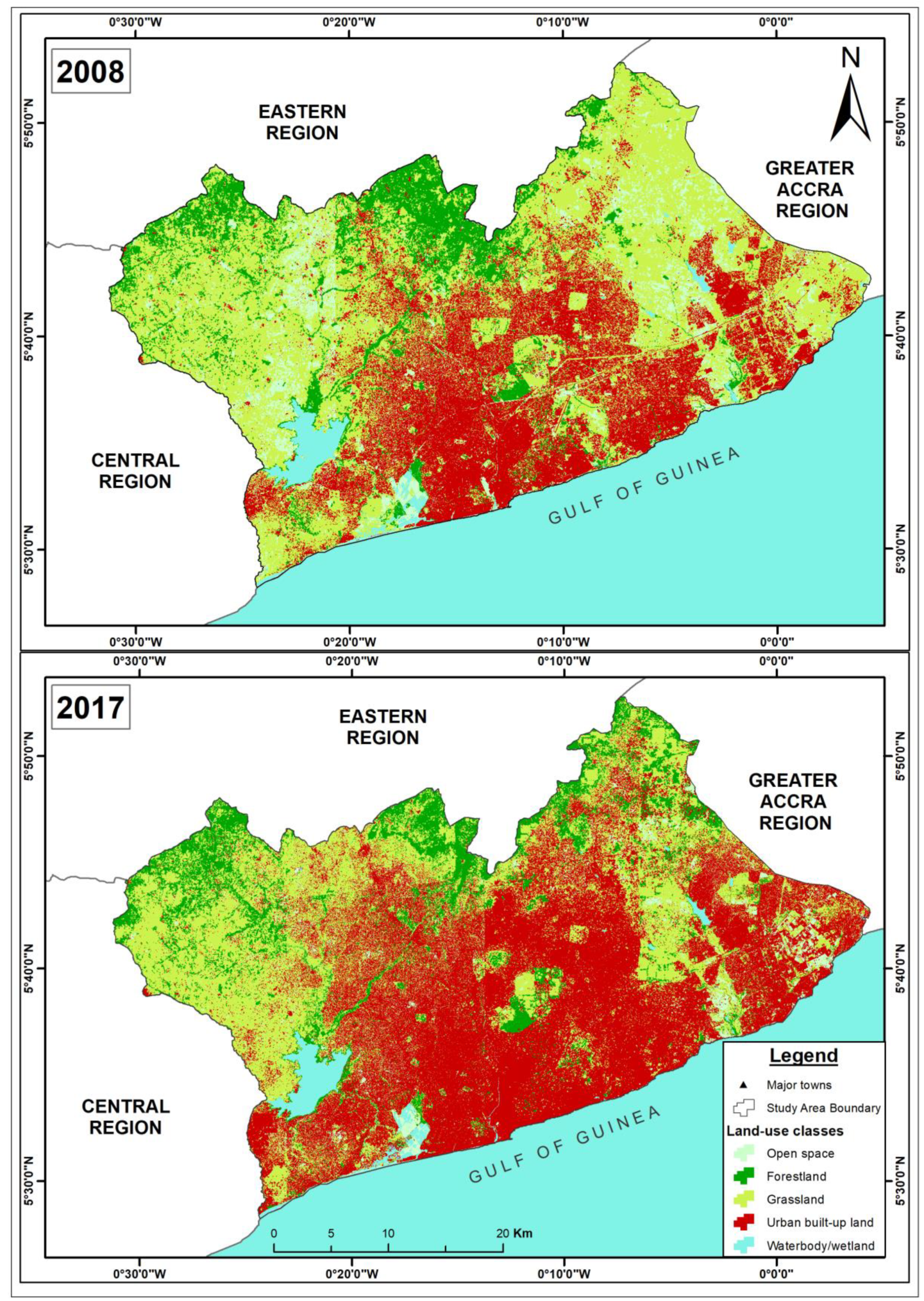
3.1. Spatio-Temporal Analysis of Land-Use Change in GAMA
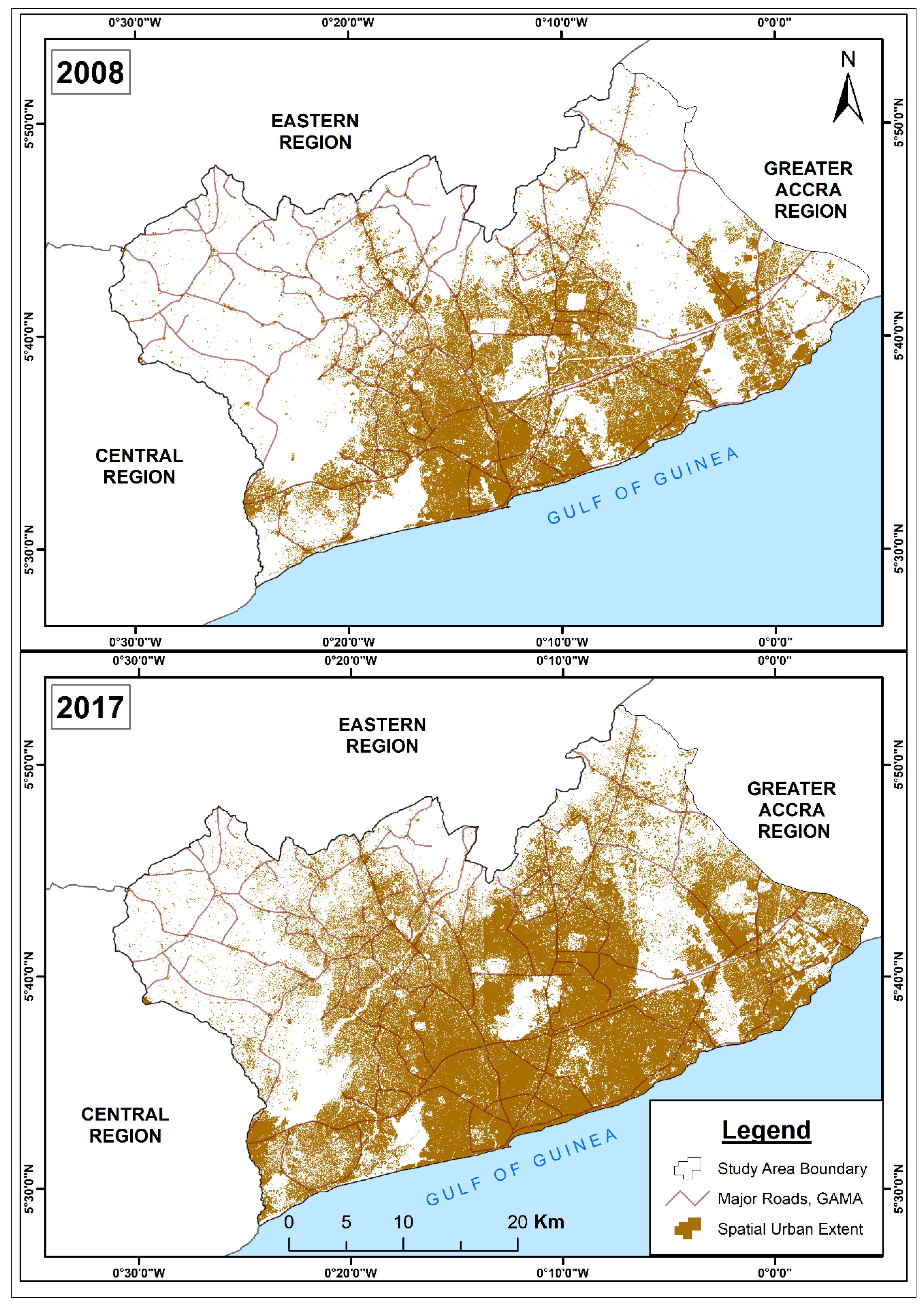
3.2. Quantifying Urban Expansion Dynamics in GAMA, 2008–2017
4. Discussion
4.1. Land-Use Change Dynamics in GAMA, 2008–2017
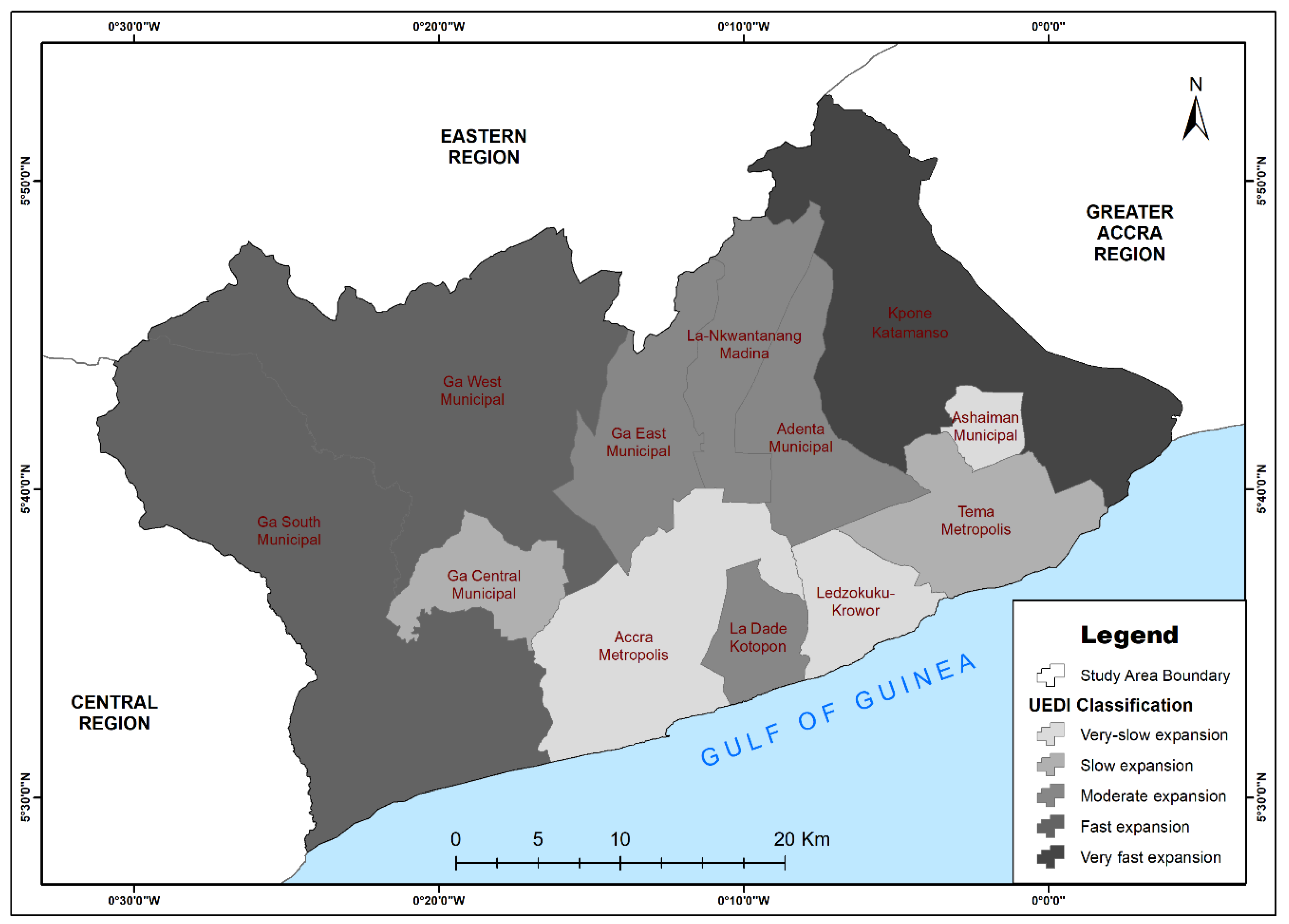
4.2. Rate, Intensity and Spatial Pattern of Urban Expansion in GAMA, 2008–2017
4.3. Implications of Findings for Regional Spatial Planning and Development
5. Conclusions
Author Contributions
Funding
Acknowledgements
Conflicts of Interest
References
- Nowosad, J.; Stepinski, T.F.; Netzel, P. Global assessment and mapping of changes in mesoscale landscapes: 1992–2015. Int. J. Appl. Earth Obs. Geoinf. 2018, 78, 332–340. [Google Scholar] [CrossRef]
- Boone, C.G.; Redman, C.L.; Blanco, H.; Haase, D.; Koch, J.; Lwasa, S.; Nagendra, H.; Pauleit, S.; Pickett, S.T.A.; Seto, K.C.; et al. Reconceptualizing land for sustainable urbanity. In Rethinking Global Land Use in an Urban Era; Seto, K.C., Reenberg, A., Eds.; MIT Press Ltd.: Cambridge, MA, USA; London, UK, 2014; pp. 313–330. [Google Scholar]
- Kopecká, M.; Nagendra, H.; Millington, A. Urban Land Systems: An Ecosystems Perspective. Land 2018, 7, 5. [Google Scholar] [CrossRef]
- Scheuer, S.; Haase, D.; Volk, M. On the Nexus of the Spatial Dynamics of Global Urbanization and the Age of the City. PLoS ONE 2016, 11, e0160471. [Google Scholar] [CrossRef] [PubMed]
- United Nations. World Urbanization Prospects 2014: Highlights; United Nations Publications: New York, NY, USA, 2014. [Google Scholar]
- Seto, K.C.; Golden, J.S.; Alberti, M.; Turner, B.L. Sustainability in an urbanizing planet. Proc. Natl. Acad. Sci. USA 2017, 114, 8935–8938. [Google Scholar] [CrossRef] [PubMed] [Green Version]
- Castanho, R.A.; Lousada, S.; Gómez, J.M.N.; Escórcio, P.; Cabezas, J.; Fernández-Pozo, L.; Loures, L. Dynamics of the Land Use Changes and the Associated Barriers and Opportunities for Sustainable Development on Peripheral and Insular Territories: The Madeira Island (Portugal); Land Use—Assessing the Past, Envisioning the Future; Loures, L.C., Ed.; IntechOpen: London, UK, 2018. [Google Scholar] [CrossRef]
- Ahrens, A.; Lyons, S. Changes in land cover and urban sprawl in Ireland from a comparative perspective over 1990–2012. Land 2019, 8, 16. [Google Scholar] [CrossRef]
- Fenta, A.A.; Yasuda, H.; Haregeweyn, N.; Belay, A.S.; Hadush, Z.; Gebremedhin, M.A.; Mekonnen, G. The dynamics of urban expansion and land use/land cover changes using remote sensing and spatial metrics: The case of Mekelle City of northern Ethiopia. Int. J. Remote Sens. 2017, 38, 4107–4129. [Google Scholar] [CrossRef]
- Akay, S.S.; Sertel, E. Urban land cover/use change detection using high-resolution Spot 5 and Spot 6 Images and Urban Atlas Nomenclature. Int. Arch. Photogramm. Remote Sens. Spat. Inf. Sci. 2016, XLI-B8, 789–796. [Google Scholar] [CrossRef]
- Masser, I. Managing our urban future: The role of remote sensing and geographic information systems. Habitat Int. 2001, 25, 503–512. [Google Scholar] [CrossRef]
- Sohl, T.; Sleeter, B. Role of Remote Sensing for land-use and land-cover change modelling. In Remote Sensing and Land Cover: Principles and Applications; Chandra, G., Ed.; Taylor and Francis CRC Press: Boca Raton, FL, USA, 2012; pp. 225–240. [Google Scholar]
- Forkuor, G.; Cofie, O. Dynamics of land-use and land-cover change in Freetown, Sierra Leone and its effects on urban and peri-urban agriculture—A remote sensing approach. Int. J. Remote Sens. 2011, 32, 1017–1037. [Google Scholar] [CrossRef]
- Owoeye, J.O.; Akinluyi, F.O. Geospatial analysis of land cover change and urban sprawl trend in Akure region, Nigeria. MOJES 2018, 3. [Google Scholar] [CrossRef]
- Seto, K.C.; Reenberg, A.; Boone, C.G.; Fragkias, M.; Haase, D.; Langanke, T.; Marcotullio, P.; Munroe, D.K.; Olah, B.; Simon, D. Urban land teleconnections and sustainability. Proc. Natl. Acad. Sci. USA 2012, 109, 7687–7692. [Google Scholar] [CrossRef] [PubMed] [Green Version]
- Addae, B.; Oppelt, N. Land-Use/Land-Cover Change Analysis and Urban Growth Modelling in the Greater Accra Metropolitan Area (GAMA), Ghana. Urban Sci. 2019, 3, 26. [Google Scholar] [CrossRef]
- Benza, M.; Weeks, J.R.; Stow, D.A.; López-Carr, D.; Clarke, K.C. A Pattern-Based Definition of Urban Context Using Remote Sensing and GIS. Remote Sens. Environ. 2016, 183, 250–264. [Google Scholar] [CrossRef] [PubMed]
- Boafo, Y.A.; Asiedu, A.B.; Appeaning-Addo, K.; Antwi, K.E.; Boakye-Danquah, J. Assessing Land-cover Changes from Coastal Tourism Development in Ghana: Evidence from the Kokrobite-Bortianor Coastline, Accra. Civ. Environ. Res. 2014, 6, 9–19. [Google Scholar]
- Oduro, C.Y.; Adamtey, R.; Ocloo, K. Urban growth and livelihood transformations on the fringes of African cities: A case study of changing livelihoods in peri-urban Accra. ENRR 2015, 5, 81. [Google Scholar] [CrossRef]
- Osei, F.E.; Balogun, B.O.; Afrifa, C.G. Identifying and quantifying urban sprawl in the Greater Accra region of Ghana from 1985 to 2014. Int. J. Sci. Res. 2015, 4, 2793–2798. [Google Scholar]
- Owusu, G. Decentralized development planning and fragmentation of metropolitan regions: The Case of the Greater Accra Metropolitan Area, Ghana. Ghana J. Geogr. 2015, 7, 1–24. [Google Scholar]
- Acheampong, R.A.; Agyemang, F.S.K.; Abdul-Fatawu, M. Quantifying the spatio-temporal patterns of settlement growth in a metropolitan region of Ghana. GeoJournal 2017, 82, 823–840. [Google Scholar] [CrossRef]
- GIBB. Greater Accra Regional Spatial Development Framework—Volume 2; Regional Spatial Development Framework Strategies and Policies Report; GIBB: Accra, Ghana, 2017. [Google Scholar]
- GOG. Ghana National Spatial Development Framework 2015–2035. Space, Efficiency and Growth; Conditions and Main Issues; Government of Ghana: Accra, Ghana, 2015; Volume I.
- Doan, P.; Oduro, C.Y. Patterns of population growth in peri-urban Accra, Ghana. Int. J. Urban Reg. Res. 2011, 36, 1306–1325. [Google Scholar] [CrossRef]
- Kleemann, J.; Inkoom, J.N.; Thiel, M.; Shankar, S.; Lautenbach, S.; Fürst, C. Peri-urban land use pattern and its relation to land use planning in Ghana, West Africa. Landsc. Urban Plan. 2017, 165, 280–294. [Google Scholar] [CrossRef]
- Ghana Statistical Service. Available online: http://www2.statsghana.gov.gh/docfiles/2010phc/Projected%20population%20by%20sex%202010%20-%202016.pdf (accessed on 19 October 2016).
- World Bank. Enhancing Urban Resilience in the Greater Accra Metropolitan Area; World Bank: Washington, DC, USA, 2017. [Google Scholar]
- National Population Council. Population of Ghana: Population and the Economy; Factsheet No. VIII; National Population Council: Accra, Ghana, 2017.
- Cities Alliance. Future Proofing Cities. 2016. Available online: https://www.arup.com/perspectives/publications/research/section/future-cities-africa (accessed on 27 August 2019).
- Yeboah, F.; Awotwi, A.; Forkuo, E.K.; Kumi, M. Assessing the Land Use and Land Cover Changes Due to Urban Growth in Accra, Ghana. J. Basic Appl. Res. Int. 2017, 22, 43–50. [Google Scholar]
- Touré, S.I.; Stow, D.A.; Clarke, K.; Weeks, J. Patterns of land cover and land-use change within the two major metropolitan areas of Ghana. Geocarto Int. 2018, 1–15. [Google Scholar] [CrossRef]
- Fichera, C.R.; Modica, G.; Pollino, M. Land cover classification and change-detection analysis using multi-temporal remote sensed imagery and landscape metrics. Eur. J. Remote Sens. 2017, 45, 1–18. [Google Scholar] [CrossRef]
- He, Y.; Dou, P.; Yan, H.; Zhang, L.; Yang, S. Quantifying the main urban area expansion of Guangzhou using Landsat imagery. Int. J. Remote Sens. 2018, 39, 7693–7717. [Google Scholar] [CrossRef]
- Larsen, L.; Yeshitela, K.; Mulatu, T.; Seifu, S.; Desta, H. The impact of rapid urbanization and public housing development on urban form and density in Addis Ababa, Ethiopia. Land 2019, 8, 66. [Google Scholar] [CrossRef]
- Liu, X.; Li, X.; Chen, Y.; Tan, Z.; Li, S.; Ai, B. A new landscape index for quantifying urban expansion using multi-temporal remotely sensed data. Landsc. Ecol. 2010, 25, 671–682. [Google Scholar] [CrossRef]
- Wang, W.; Li, W.; Zhang, C.; Zhang, W. Improving Object-Based Land Use/Cover Classification from Medium Resolution Imagery by Markov Chain Geostatistical Post-Classification. Land 2018, 7, 31. [Google Scholar] [CrossRef]
- Foerster, S.; Carrère, V.; Rast, M.; Staenz, K. Preface: The Environmental Mapping and Analysis Program (EnMAP) Mission: Preparing for Its Scientific Exploitation. Remote Sens. 2016, 8, 957. [Google Scholar] [CrossRef]
- Liu, J.; Li, H.; Gu, H. A color balancing method for wide range Remote Sensing imagery based on Regionalization. Int. Arch. Photogramm. Remote Sens. Spat. Inf. Sci. 2015, XL-7/W4, 103–108. [Google Scholar] [CrossRef] [Green Version]
- Egenhofer, M.F.; Frank, A. Object-oriented modelling for GIS. J. Urban Reg. Inf. Syst. Assoc. 1992, 4, 3–19. [Google Scholar]
- Weng, Q. Remote Sensing and GIS Integration: Theories, Methods, and Applications; McGraw-Hill: New York, NY, USA, 2010. [Google Scholar]
- Trimble Geospatial. eCognition Developer 9.0. Available online: http://www.ecognition.com (accessed on 27 August 2019).
- Owusu, G. The role of small towns in regional development and poverty reduction in Ghana. Int. J. Urban Reg. Res. 2008, 32, 453–472. [Google Scholar] [CrossRef]
- Trimble Germany GmbH. Trimble Documentation: eCognition Developer 9.0 User Guide; Trimble Germany GmbH: Munich, Germany, 2014. [Google Scholar] [CrossRef]
- Abdullahi, S.; Pradhan, B. Urban expansion and change detection. In Spatial Modelling and Assessment of Urban Form; Pradhan, B., Ed.; Springer International Publishing AG: Basel, Switzerland, 2017. [Google Scholar]
- Butt, A.; Shabbir, R.; Ahmad, S.S.; Aziz, N. Land use change mapping and analysis using Remote Sensing and GIS: A case study of Simly watershed, Islamabad, Pakistan. Egypt. J. Remote Sens. Space Sci. 2015, 18, 251–259. [Google Scholar] [CrossRef] [Green Version]
- Lu, S.; Guan, X.; He, C.; Zhang, J. Spatio-Temporal Patterns and Policy Implications of Urban Land Expansion in Metropolitan Areas: A Case Study of Wuhan Urban Agglomeration, Central China. Sustainability 2014, 6, 4723–4748. [Google Scholar] [CrossRef] [Green Version]
- Qiuying, L.; Chuanglin, F.; Guangdong, L.; Zhoupeng, R. Quantitative Measurement of Urban Expansion and its Driving Factors in Qingdao: An Empirical Analysis Based on County Unit Data. J. Resour. Ecol. 2015, 6, 172–179. [Google Scholar] [CrossRef]
- Rode, P.; Heeckt, C.; Ahrend, R.; Huerta-Melchor, O.; Robert, A.; Badstuber, N.; Hoolachan, A.; Kwami, C. Integrating National Policies to Deliver Compact, Connected Cities: An Overview of Transport and Housing; Coalition for Urban Transitions: London, UK; Washington, DC, USA, 2017. [Google Scholar]
- Altman, D.G. Practical Statistics for Medical Research, 1st ed.; Chapman & Hall: London, UK, 1991. [Google Scholar]
- Stow, D.A.; Weeks, J.R.; Touré, S.I.; Coulter, L.; Lippitt, C.D.; Ashcroft, E. Urban vegetation cover and vegetation change in Accra, Ghana: Connection to Housing Quality. Prof. Geogr. J. Assoc. Am. Geogr. 2013, 65. [Google Scholar] [CrossRef]
- Angel, S.; Blei, A.M.; Civco, D.L.; Parent, J. Atlas of Urban Expansion, Areas and Densities, 2016 ed.; New York University: New York, NY, USA; UB-Habitat: Nairobi, Kenya; Lincoln Institute of Land Policy: Cambridge, MA, USA, 2016; Volume 1. [Google Scholar]
- Agyemang, F.S.K.; Amedzro, K.K.; Silva, E. The emergence of city-regions and their implications for contemporary spatial governance: Evidence from Ghana. Cities 2017, 71, 70–79. [Google Scholar] [CrossRef] [Green Version]
- Touré, S.I. Urban Land Cover and Land-Use Change in Ghana: Connections to Demography and Health. Ph.D. Thesis, University of California, Santa Barbara, CA, USA, 2017. [Google Scholar]
- Owusu, G. Coping with Urban sprawl: A critical discussion of the urban containment strategy in a developing city, Accra. Planum. J. Urban. 2013, 1, 1–27. [Google Scholar]
- INTI. New, New Towns: Tema-Ghana. International New Town Institute, Rotterdam-the Netherlands. Available online: https://www.newtowninstitute.org/spip.php?rubrique64 (accessed on 20 November 2018).
- GSS. Urbanization in Ghana. 2010 Population and Housing Census Report; Ghana Statistical Service: Accra, Ghana, 2014.
- Stow, D.A.; Weeks, J.R.; Shih, H.-C.; Coulter, L.L.; Johnson, H.; Tsai, Y.-H.; Kerr, A.; Benza, M.; Mensah, F. Inter-regional pattern of urbanization in southern Ghana in the first decade of the new millennium. Appl. Geogr. 2016, 71, 32–43. [Google Scholar] [CrossRef] [Green Version]
- Bhatta, B. Analysis of urban growth pattern using remote sensing and GIS: A case study of Kolkata, India. Int. J. Remote Sens. 2009, 30, 4733–4746. [Google Scholar] [CrossRef]
- Rahimi, A. A methodological approach to urban land-use change modeling using infill development pattern—a case study in Tabriz, Iran. Ecological Processes 2016, 5. [Google Scholar] [CrossRef]
- Adam, A.G. Land tenure in the changing peri-urban areas of Ethiopia: The Case of Bahir Dar City. Int. J. Urban Reg. Res. 2014, 38, 1970–1984. [Google Scholar] [CrossRef]
- Bartels, L.E.; Bruns, A.; Alba, R. The Production of Uneven Access to Land and Water in Peri-urban Spaces: De Facto Privatisation in Greater Accra. Local Environ. 2018, 23, 1172–1189. [Google Scholar] [CrossRef]
- McGregor, D.; Simon, D.; Thompson, D. (Eds.) The Peri-Urban Interface: Approaches to Sustainable Natural and Human Resource Use; Routledge: London, UK, 2006. [Google Scholar]
- Alonso, W. Location and Land Use; Toward a General Theory of Land Rent; Publications of the Joint Center for Urban Studies of the Massachusetts Institute of Technology and Harvard University; Harvard University Press: Cambridge, MA, USA, 1964. [Google Scholar]
- Haggett, P. Geography. A Global Synthesis; Prentice-Hall: Harlow, UK, 2001. [Google Scholar]
- Murphy, E.E.; Vance, J.E. Delimiting the CBD. Econ. Geogr. 1954, 30, 189–222. [Google Scholar] [CrossRef]
- Yu, W.; Ai, T.; Shao, S. The analysis and delimitation of Central Business District using network kernel density estimation. J. Transp. Geogr. 2015, 45, 32–47. [Google Scholar] [CrossRef]
- DTCP-MLG. Strategic Plan for the Greater Accra Metropolitan Area; Department of Town and Country Planning (Ministry of Local Government): Accra, Ghana, 1991.
- Gough, K.V.; Yankson, P.W.K. A Neglected Aspect of the Housing Market: The Caretakers of Peri-urban Accra, Ghana. Urban Stud. 2011, 48, 793–810. [Google Scholar] [CrossRef]
- Yankson, P.W.K.; Gough, K.V. The environmental impact of rapid urbanization in the peri-urban area of Accra, Ghana. Geogr. Tidsskr.-Dan. J. Geogr. 1999, 99, 89–100. [Google Scholar] [CrossRef]
- Caldeira, T.P. Peripheral urbanization: Autoconstruction, transversal logic, and politics in cities of the global south. Environ. Plan. D Soc. Space 2017, 35, 3–20. [Google Scholar] [CrossRef]
- Asiedu, A.B.; Arku, G. The rise of gated housing estates in Ghana: Empirical insights from three communities in metropolitan Accra. J. Hous. Built Environ. 2009, 24, 227–247. [Google Scholar] [CrossRef]
- Obeng-Odoom, F. Urban Real Estate in Ghana: A Study of Housing-related Remittances from Australia. Hous. Stud. 2010, 25, 357–373. [Google Scholar] [CrossRef]
- CAHF. Housing Finance in Africa; A Review of Africa’s Housing Finance Markets; The 2018 Year Book; Center for Affordable Housing Finance in Africa: Johannesburg, South Africa, 2018. [Google Scholar]
- Akubia, J.E.K.; Bruns, A. Concrete Jungles and Punctuated Landscapes in Peri-Urban Accra. How Does Real Estate Developers Play a Role? A Poster Presented at Deutscher Kongress für Geographie: Tübingen, Germany, 2017. [Google Scholar]
| 1 | Throughout this paper, the descriptors “urbanization” and “urban expansion” are used interchangeably to refer to spatial transformation of land relative to rapid increase in the quantum of urban built-up area. |
| 2 | The term “urban sprawl” is used herein to describe the process of unsustainable physical outward expansion of urban areas, typically characterized by low-density development, uncontrolled and unplanned growth, and often foreruns the installation of basic municipal and engineering services and infrastructure. It is the predominant form and process through which urbanization and major land-use changes in GAMA materialize. |
| 3 | Given that images with high spatial resolution have poor temporal resolution, the availability of a single image covering large areas is limited, thus the most historical imagery covering the selected study area is a constellation of 2008/2009 images (hereafter referred to as “2008” imagery). |
| 4 | In the context of GAMA and Ghana as a whole, urban centers are officially defined as settlements with populations of 5000 or more. Below the urban centers are settlements considered “rural” or “village” with populations less than 5000. Above the urban centers are “small towns”, which are localities with a population between 5000 and 19,999. At the top are the “large towns”, being localities that have 20,000 or more populations and “cities” with populations of 250,000, e.g., Accra and Tema [43]. |
| 5 | Population data for 2008 and 2017 in Table 3 are based on estimates compiled from the 2010 population and housing census report and Ghana Statistical service (web). |


| Data Type and Materials | Data Source | Method of Data Collection |
|---|---|---|
| Worldview 2 imagery, 2017Quickbird + Worldview 2 imagery, 2008/20093 | DigitalGlobe/European Spacing Agency | Purchased (with 1.5 m resolution and four multispectral bands: blue, green, red, and near-infrared wavelengths. |
| Ground survey field attributes/training data | Field-captured data | GPS point measurement and collector for ArcGIS |
| Metropolitan and District boundary (shapefile), 2016 | Town and Country Planning Department (TCPD) | Collected from the TCPD office in Accra |
| Google Earth image 2008, 2017 | Online sources | Download |
| Initial State (2008) | |||||||
|---|---|---|---|---|---|---|---|
| Final State (2017) | Open Space | Forestland | Grassland | Urban Built-Up Area | Waterbody/ Wetland | Total | |
| Open Space | 18.26 | 2.83 | 37.41 | 11.51 | 1.63 | 71.64 | |
| Forestland | 9.41 | 78.88 | 90.11 | 5.29 | 1.32 | 185.01 | |
| Grassland | 65.02 | 72.60 | 345.27 | 34.08 | 1.77 | 518.73 | |
| Urban built-up Area | 60.78 | 26.61 | 239.04 | 360.41 | 2.23 | 689.07 | |
| Waterbody/Wetland | 1.62 | 0.65 | 1.19 | 0.16 | 29.00 | 32.62 | |
| Total | 155.10 | 181.56 | 713.02 | 411.45 | 35.94 | ||
| Class Change | 136.84 | 102.68 | 367.75 | 51.05 | 6.94 | ||
| Image Difference | −83.46 | 3.45 | −194.29 | 277.61 | −3.32 | ||
| Administrative Districts in GAMA | Population5 | Total Area (km2) | Built-Up Land (km2) | AUER (%) | UEII (%) | UEDI (km2) | ||
|---|---|---|---|---|---|---|---|---|
| 2008 | 2017 | 2008 | 2017 | 2008–2017 | 2008–2017 | 2008–2017 | ||
| Accra Metropolis | 1,665,086 | 2,087,668 | 139.67 | 96.02 | 113.96 | 1.92 | 1.43 | 0.28 |
| Adenta Municipal | 78,215 | 93,158 | 77.94 | 31.83 | 53.68 | 5.98 | 3.12 | 1.02 |
| Ashaiman Municipal | 190,972 | 231,096 | 18.55 | 11.41 | 13.51 | 1.9 | 1.26 | 0.27 |
| Ga Central Municipal | 117,220 | 141,070 | 49.00 | 22.50 | 33.64 | 4.57 | 2.53 | 0.73 |
| Ga East Municipal | 147,742 | 179,107 | 85.66 | 33.20 | 55.02 | 5.77 | 2.83 | 0.97 |
| Ga South Municipal | 411,377 | 521,162 | 341.84 | 41.70 | 85.60 | 8.32 | 1.43 | 1.56 |
| Ga West Municipal | 219,788 | 268,557 | 299.58 | 39.83 | 90.29 | 9.52 | 1.87 | 1.88 |
| Kpone Katamanso | 109,864 | 132,070 | 239.86 | 22.97 | 80.71 | 14.98 | 2.67 | 3.72 |
| La Dade Kotopon | 183,528 | 221,284 | 36.03 | 17.24 | 29.50 | 6.15 | 3.78 | 1.05 |
| La Nkwantanang | 111,926 | 134,837 | 70.89 | 20.54 | 38.03 | 7.08 | 2.74 | 1.26 |
| Ledzokuku Krowor | 227,932 | 275,239 | 47.58 | 33.72 | 43.67 | 2.92 | 2.32 | 0.44 |
| Tema Metropolis | 292,773 | 353,086 | 87.81 | 40.49 | 55.71 | 3.61 | 1.93 | 0.56 |
© 2019 by the authors. Licensee MDPI, Basel, Switzerland. This article is an open access article distributed under the terms and conditions of the Creative Commons Attribution (CC BY) license (http://creativecommons.org/licenses/by/4.0/).
Share and Cite
Akubia, J.E.K.; Bruns, A. Unravelling the Frontiers of Urban Growth: Spatio-Temporal Dynamics of Land-Use Change and Urban Expansion in Greater Accra Metropolitan Area, Ghana. Land 2019, 8, 131. https://doi.org/10.3390/land8090131
Akubia JEK, Bruns A. Unravelling the Frontiers of Urban Growth: Spatio-Temporal Dynamics of Land-Use Change and Urban Expansion in Greater Accra Metropolitan Area, Ghana. Land. 2019; 8(9):131. https://doi.org/10.3390/land8090131
Chicago/Turabian StyleAkubia, John E. K., and Antje Bruns. 2019. "Unravelling the Frontiers of Urban Growth: Spatio-Temporal Dynamics of Land-Use Change and Urban Expansion in Greater Accra Metropolitan Area, Ghana" Land 8, no. 9: 131. https://doi.org/10.3390/land8090131
APA StyleAkubia, J. E. K., & Bruns, A. (2019). Unravelling the Frontiers of Urban Growth: Spatio-Temporal Dynamics of Land-Use Change and Urban Expansion in Greater Accra Metropolitan Area, Ghana. Land, 8(9), 131. https://doi.org/10.3390/land8090131