Farms or Forests? Understanding and Mapping Shifting Cultivation Using the Case Study of West Garo Hills, India


Abstract
:
1. Introduction
2. Defining, Mapping and Analyzing Land-Use/Land-Cover in Shifting Cultivation Landscapes
2.1. Classifying Shifting Cultivation Landscapes
2.2. Mapping Shifting Cultivation Stages, Forests, and Forest-Like Land-Uses
2.3. Mapping to Identify Spatial Patterns in Fallow Periods/Land-Use Intensity of Shifting Cultivation
2.4. Shifting Cultivation Mapping in South Asia
3. Approach and Objectives
- Given that the debate on shifting cultivation is driven by both biodiversity concerns and agricultural productivity/sustainability concerns, we seek to distinguish between (secondary forest-like) old fallows, old-growth forest, and horticultural tree plantations, and also between active shifting cultivation fields and wet rice valley cultivation, and between young and old fallows.
- Given the similarities with other (non-forest and non-shifting cultivation) land-uses, we seek to demonstrate the importance of using two-season data and substantial ground truth to achieve such a separation.
- Given the concern about possible declines in fallow periods, we propose the use of fallow: active shifting cultivation ratios to estimate the fallow duration in different sub-regions and the possibility of relating the variation in these ratios across the landscape with other land-uses in and demography of these sub-regions.
- Applying these methodological improvements to a site in Northeast India, we estimate the extent of active and fallow shifting cultivation, old-growth forest and other land-uses in that region, and compare our findings with existing estimates to highlight our empirical contribution. We also identify possible correlates of shifting cultivation intensities and their implications.
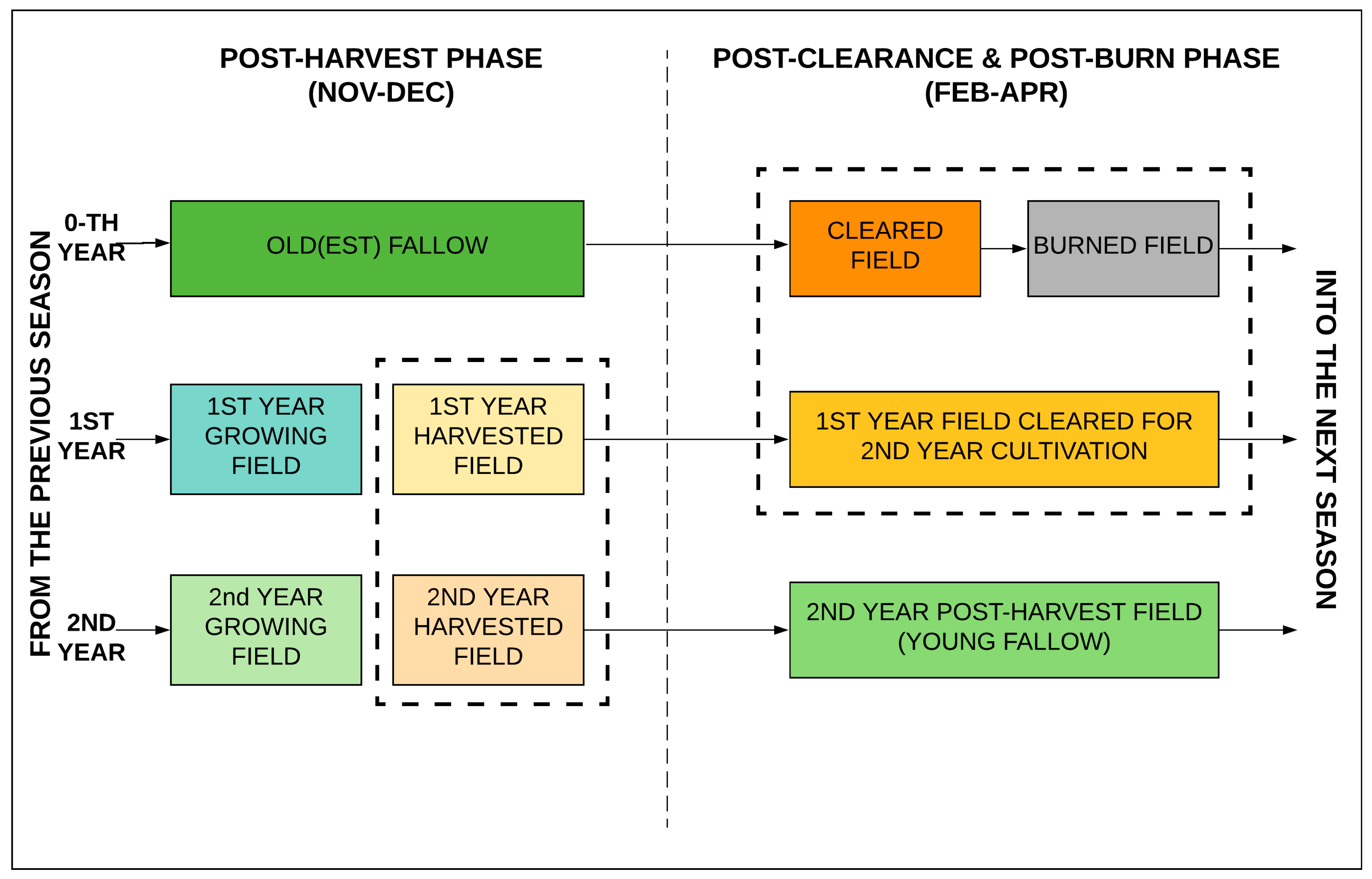
4. Study Area and Methods
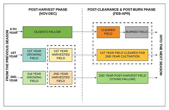
4.1. Study Area and Major Land-Uses
- Active shifting cultivation (first and second year)
- Young fallow (1–10 years fallow period or 3–12 years post-burning)
- Old fallow (11–20 years fallow period or 13–22 years post-burning)
- Old-growth forest (>20 years fallow period)
- Horticultural plantations (cashew, areca, rubber)
- Wet rice (valley) cultivation
- Other (mixed/home garden) cultivation
- Water bodies
4.2. Methodology
4.2.1. Choice of Imagery
4.2.2. Ground Data Collection
4.2.3. Image Processing, Classification and Validation
4.2.4. Estimating the Fallow Period
5. Results
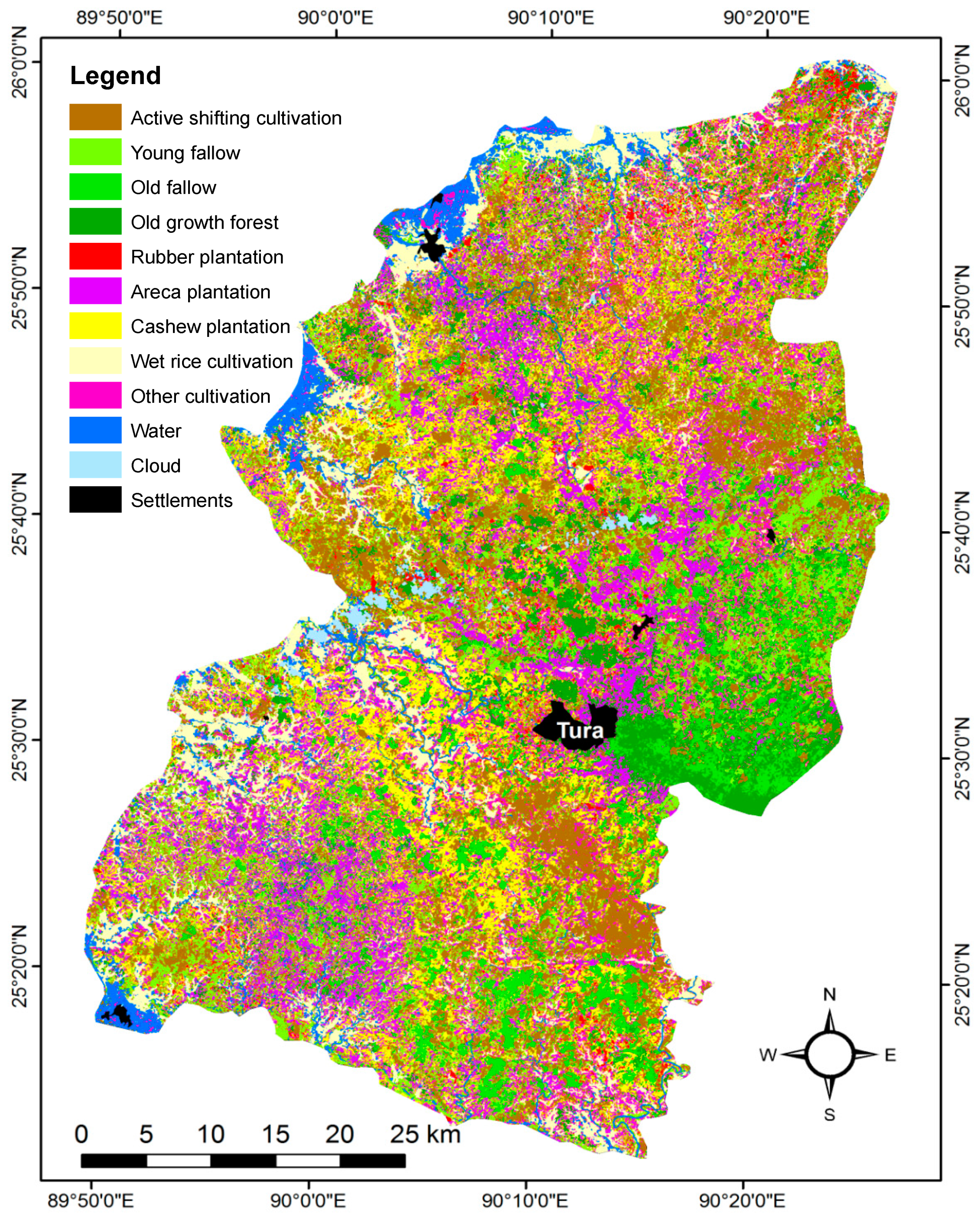
5.1. Land-Uses in West Garo Hills District
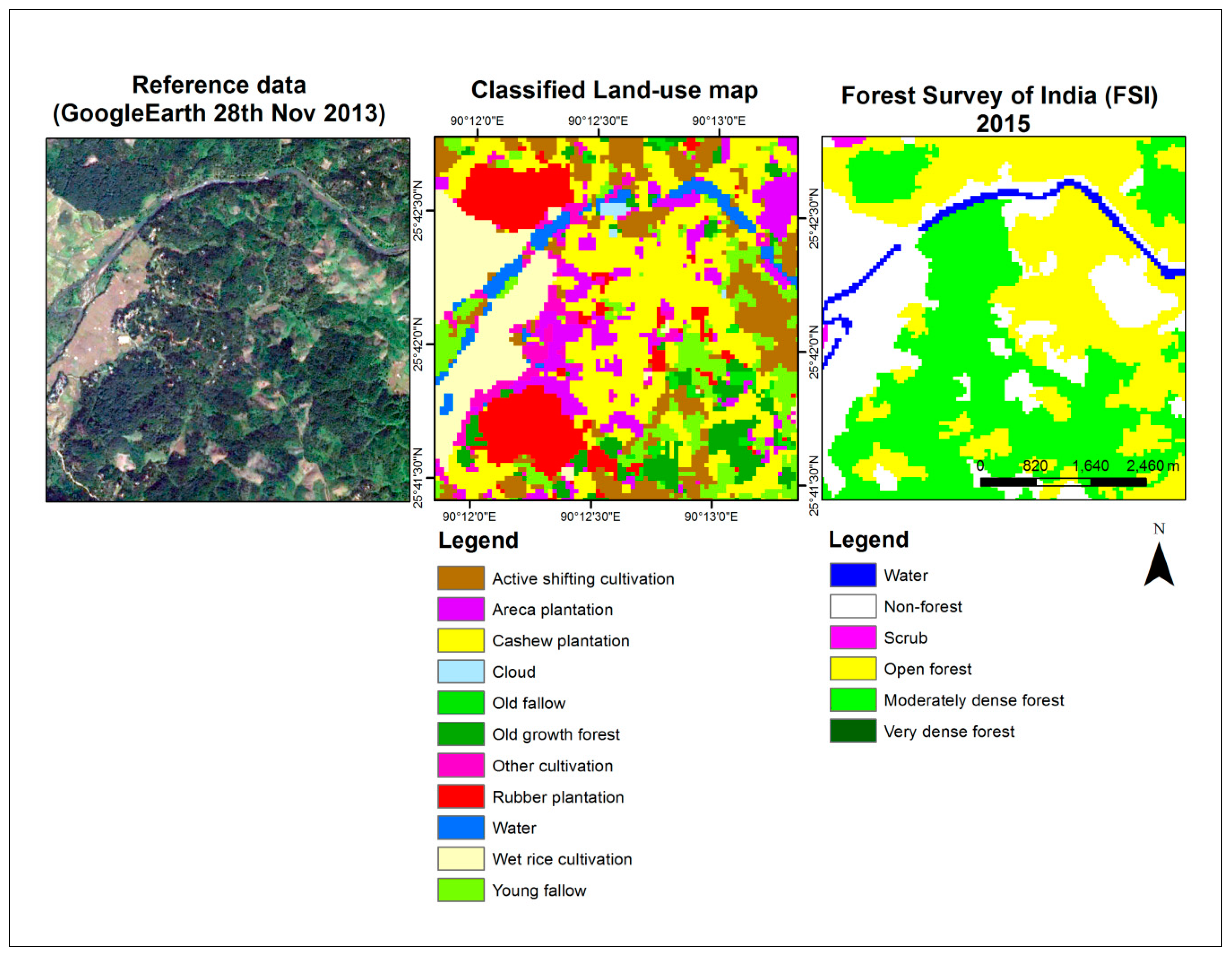
5.2. Map Accuracy
- (1)
- The aggregated active shifting cultivation class gets classified very well, with 89% and 91% accuracy. As the sub-matrix for the sub-classes of active cultivation shows (Table 1), there is some confusion amongst them, but aggregation improves the overall accuracy of this class.
- (2)
- Wet rice cultivation is easily discriminated from shifting cultivation and other classes (83% and 98% accuracy). Unlike in other studies [45], no slope information had to be added to make this possible.
- (3)
- The forest-like horticultural plantations are also identified fairly well. Amongst these, rubber and cashew are identified well (rubber: 93%; cashew: 78% and 89%), while areca is mapped with much lower user’s accuracy (58% and 89%) because of the occasional confusion with old-growth forest, fallow component of 0th year active shifting cultivation classes, as well as other plantation classes. Plantation area, especially under areca and rubber, is likely to be an underestimate since many fields with young plantation saplings are sparsely vegetated and can be confused with young fallows or maybe even 2nd year active shifting cultivation areas.
- (4)
- The fallows—young and old—are discriminated with limited accuracy (50% or lower), although the producer’s accuracy for old fallow is quite high (89%). Young fallows include the 2nd year fields that were cultivated and harvested in November and then fallowed, where the signature is changing within the year and hence creating confusion with other categories. Old fallows, not surprisingly, get confused with forest, but also with young fallows—an indication of the fluidity or diversity in the fallow category. The confusion with fallows could have been avoided if the analysis was carried out in a single agricultural year. But lack of cloud-free imagery from post-clearance/post-burn (summer) period of 2013 and post-harvest period of 2014 made that impossible.
- (5)
- The classification accuracy of old-growth forest is 58% (user’s accuracy) and 66% (producer’s accuracy), which is moderate. Confusion with the older fallows and young fallows is the primary reason. Shifting cultivation landscape are active production landscapes and hence old-growth forests are essentially relatively undisturbed or mature secondary regrowth forest and are occasionally used for bamboo and timber extraction for construction that creates canopy openings making them resemble fallows. Conversely, fallows contain several trees that are actively planted and that tend to make fallows resemble older forests in satellite imagery.
5.3. Land–Use Extents
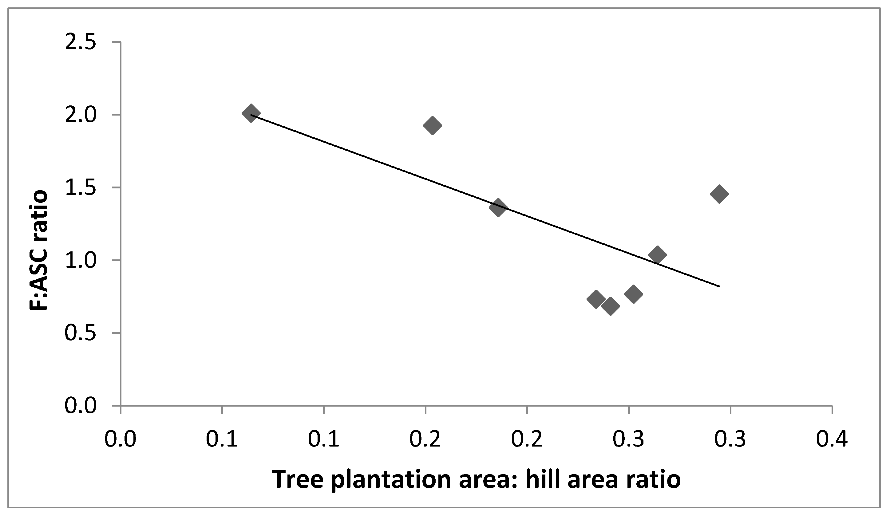
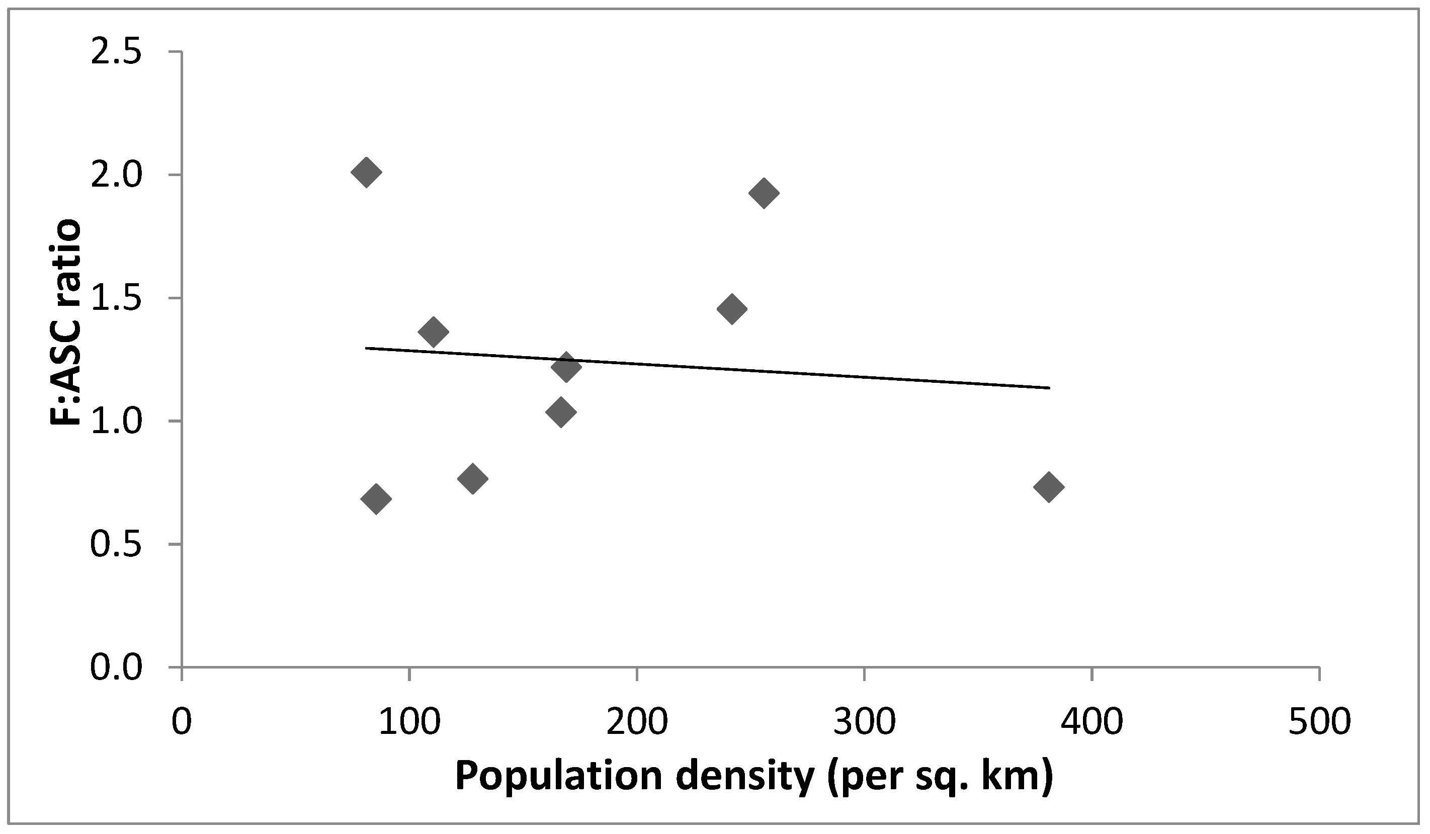
5.4. Patterns in, and Correlates of Fallow Periods
6. Discussion
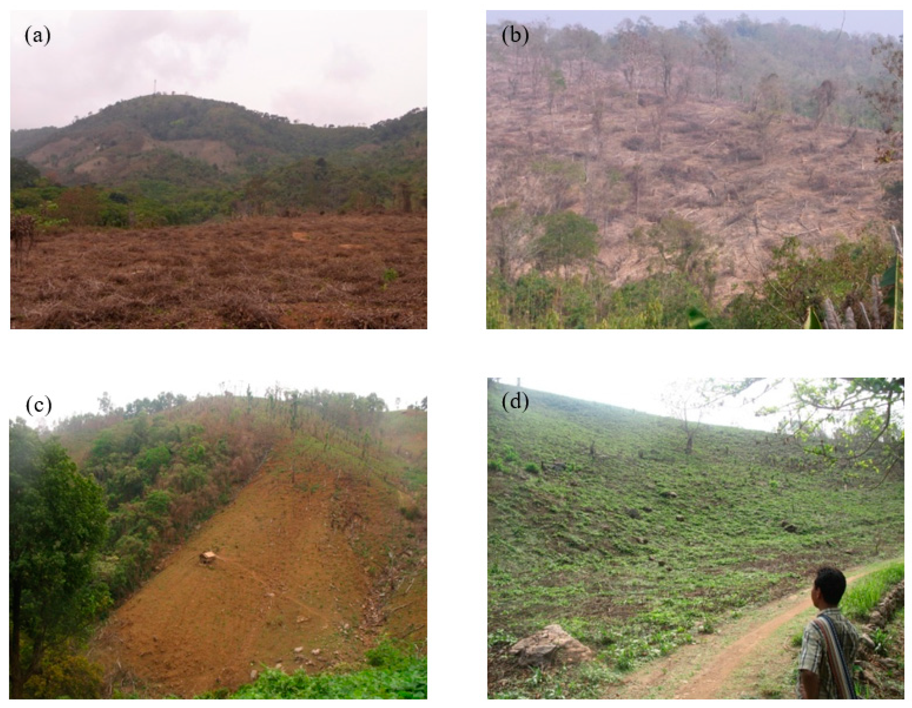
6.1. Occulted Farms
6.2. Imagined Forests and Spurious Deforestation
6.3. Fallow Periods and Correlates of Fallow Land-Use Intensity
6.4. Methodological Issues in Mapping Complex Shifting Cultivation Landscapes
7. Conclusions
Supplementary Materials
Author Contributions
Funding
Acknowledgments
Conflicts of Interest
References
- Cramb, R.; Colfer, C.J.P.; Dressler, W.; Laungaramsri, P.; Trang Le, Q.; Mulyoutami, E.; Peluso, N.L.; Wadley, R.L. Swidden Transformation and Rural Livelihoods in Southeast Asia. Hum. Ecol. 2009, 37, 323–346. [Google Scholar] [CrossRef]
- Van Vliet, N.; Mertz, O.; Heinimann, A.; Langanke, T.; Pascual, U.; Schmook, B.; Adams, C.; Schmidt-Vogt, D.; Messerli, P.; Leisz, S.; et al. Trends, drivers and impacts of changes in swidden cultivation in tropical forest-agriculture frontiers: A global assessment. Glob. Environ. Chang. 2012, 22, 418–429. [Google Scholar] [CrossRef]
- Fox, J.; Castella, J.-C.; Ziegler, A.D. Swidden, Rubber and Carbon: Can REDD+ work for people and the environment in Montane Mainland Southeast Asia? In CCAFS Working Paper No. 9. CGIAR Research Program on Climate Change, Agriculture and Food Security (CCAFS); CGIAR: Copenhagen, Denmark, 2011; Available online: www.ccafs.cgiar.org (accessed on 28 August 2019).
- Ziegler, A.; Bruun, T.B.; Guardiola-Claramonte, M.; Giambelluca, T.W.; Lawrence, D.; Lam, N.T. Environmental Consequences of the Demise in Swidden Cultivation in Montane Mainland Southeast Asia: Hydrology and Geomorphology. Hum. Ecol. 2009, 37, 361–373. [Google Scholar] [CrossRef]
- Bruun, T.B.; Neergaard, A.D.; Lawrence, D.; Ziegler, A.D. Environmental Consequences of the Demise in Swidden Cultivation in Southeast Asia: Carbon Storage and Soil Quality. Hum. Ecol. 2009, 37, 375–388. [Google Scholar] [CrossRef]
- Myers, N. Tropical forests: The policy challenge. Environmentalist 1992, 12, 15–27. [Google Scholar] [CrossRef]
- FAO. Shifting cultivation. Unasylva 1957, 11, 9–11. [Google Scholar]
- Schmidt-Vogt, D.; Leisz, S.; Mertz, O.; Heinimann, A.; Thiha, T.; Messerli, P.; Epprecht, M.; Cu, P.; Chi, V.; Hardiono, M.; et al. An Assessment of Trends in the Extent of Swidden in Southeast Asia. Hum. Ecol. 2009, 37, 269–280. [Google Scholar] [CrossRef]
- Heinimann, A.; Mertz, O.; Frolking, S.; Egelund Christensen, A.; Hurni, K.; Sedano, F.; Parsons Chini, L.; Sahajpal, R.; Hansen, M.; Hurtt, G. A global view of shifting cultivation: Recent, current, and future extent. PLoS ONE 2017, 12, e0184479. [Google Scholar] [CrossRef]
- Ickowitz, A.; Rowland, D.; Powell, B.; Salim, M.A.; Sunderland, T. Forests, Trees, and Micronutrient-Rich Food Consumption in Indonesia. PLoS ONE 2016, 11, e0154139. [Google Scholar] [CrossRef]
- Ellen, R. Studies of Swidden Agriculture in Southeast Asia since 1960: An Overview and Commentary on Recent Research and Synthesis. Asia Pac. World 2012, 3, 18–38. [Google Scholar] [CrossRef]
- Kerkhoff, E.; Sharma, E. Debating Shifting Cultivation in the Eastern Himalayas: Farmers’ Innovations as Lessons for Policy; ICIMOD: Kathmandu, Nepal, 2006. [Google Scholar]
- Spencer, J.E. Shifting Cultivation in Southeastern Asia; University of California Press: Berkeley, CA, USA, 1966. [Google Scholar]
- Rasul, G.; Thapa, G.B. Shifting Cultivation in the Mountains of South and Southeast Asia: Regional patterns and factors influencing the change. Land Degrad. Dev. 2003, 14, 495–508. [Google Scholar] [CrossRef]
- Ramakrishnan, P.S. Shifting Agriculture and Sustainable Development: An Interdisciplinary Study from North Eastern India; UNESCO/the Parthenon Publishing Group: Paris, France, 1992; Volume 10. [Google Scholar]
- Ranjan, R.; Upadhyay, V.P. Ecological problems due to shifting cultivation. Curr. Sci. 1999, 77, 1246–1250. [Google Scholar]
- Manhas, R.K.; Negi, J.D.S.; Kumar, R.; Chauhan, P.S. Temporal Assessment of Growing stock, Biomass and Carbon stock of Indian Forests. Clim. Chang. 2006, 74, 191–221. [Google Scholar] [CrossRef]
- MOA-GOI. Watershed Development Project in Shifting Cultivation Areas (WDPSCA); Ministry of Agriculture, Natural Resource Management Division, Government of India, Eds.; Government of India: New Delhi, India, 2012; p. 27.
- SWC-GOM. Shifting Cultivation. Available online: http://megsoil.gov.in/shifting_cul.html (accessed on 28 August 2019).
- NLUP. New Land Use Policy (NLUP). Available online: https://nlup.mizoram.gov.in/ (accessed on 30 March 2019).
- Talukdar, G.; Ghosh, S.; Roy, P.S. Landscape Dynamics in North East Region of India (Meghalaya State) Using Spatial Decision Tree Model. Geocarto Int. 2004, 19, 11–18. [Google Scholar] [CrossRef]
- Behera, M.D.; Tripathi, P.; Das, P.; Srivastava, S.K.; Roy, P.S.; Joshi, C.; Behera, P.R.; Deka, J.; Kumar, P.; Khan, M.L.; et al. Remote sensing based deforestation analysis in Mahanadi and Brahmaputra river basin in India since 1985. J. Environ. Manag. 2018, 206, 1192–1203. [Google Scholar] [CrossRef] [PubMed]
- Cihlar, J.; Jansen, L.J.M. From land cover to land use: A methodology for efficient land use mapping over large areas. Prof. Geogr. 2001, 53, 275–289. [Google Scholar] [CrossRef]
- Wilkie, D.S. Remote Sensing Imagery for Resource Inventories in Central Africa: The Importance of Detailed Field Data. Hum. Ecol. 1994, 22, 379–403. [Google Scholar] [CrossRef]
- Brookfield, H. Exploring Agrodiversity; Columbia University Press: New York, NY, USA, 2001; Volume 42, pp. 181–192. [Google Scholar]
- Amelung, T.; Diehl, M. Deforestation of Tropical Rain Forests: Economic Causes and Impact on Development; Institut für Weltwirtschaft: Kiel, Germany, 1992. [Google Scholar]
- Eckholm, E.P. The Deterioration of Mountain Environments. Science 1975, 189, 764–770. [Google Scholar] [CrossRef]
- FAO. Shifting Cultivation and Soil Conservation in Africa; Food and Agricultural Organisation (FAO): Rome, Italy, 1974. [Google Scholar]
- Greenland, D.J. Bringing the Green Revolution to the Shifting Cultivator. Science 1975, 190, 841–844. [Google Scholar] [CrossRef]
- Brady, N.C. Alternatives to slash-and-burn: A global imperative. Agric. Ecosyst. Environ. 1996, 58, 3–11. [Google Scholar] [CrossRef]
- Myers, N.; Fox, J.; Rambo, A.T.; Truong, D.M.; Tuyen, N.P.; Cuc, L.T.; Leisz, S. Shifting versus shifted cultivators. BioScience 2000, 50, 845–846. [Google Scholar] [CrossRef]
- Lawrence, D.; Radel, C.; Tully, K.; Schmook, B.; Schneider, L. Untangling a Decline in Tropical Forest Resilience: Constraints on the Sustainability of Shifting Cultivation across the Globe. Biotropica 2010, 42, 21–30. [Google Scholar] [CrossRef]
- Dalle, S.P.; Pulido, M.T.; De Blois, S. Balancing shifting cultivation and forest conservation: Lessons from a ‘‘sustainable landscape’’ in southeastern Mexico. Ecol. Appl. 2011, 21, 1557–1572. [Google Scholar] [CrossRef] [PubMed]
- Herold, M.; Latham, J.S.; Gregorio, A.D.; Schmullius, C.C. Evolving standards in land cover characterization. J. Land Use Sci. 2006, 1, 157–168. [Google Scholar] [CrossRef] [Green Version]
- Gong, P.; Yu, L.; Li, C.; Wang, J.; Liang, L.; Li, X.; Ji, L.; Bai, Y.; Cheng, Y.; Zhu, Z. A new research paradigm for global land cover mapping. Ann. GIS 2016, 22, 87–102. [Google Scholar] [CrossRef] [Green Version]
- Axelsen, B.; Jones, M. Are all maps mental maps? GeoJournal 1987, 14, 447–464. [Google Scholar] [CrossRef]
- Comber, A.J.; Fisher, P.F.; Wadsworth, R.A. Land cover: To standardise or not to standardise? Comment on ‘Evolving standards in land cover characterization’ by Herold et al. J. Land Use Sci. 2007, 2, 283–287. [Google Scholar] [CrossRef]
- Robbins, P. Fixed categories in a portable landscape: The causes and consequences of land-cover categorization. Environ. Plan. A Econ. Space 2001, 33, 161–179. [Google Scholar] [CrossRef]
- Comber, A.J.; Wadsworth, R.A.; Fisher, P.F. Using semantics to clarify the conceptual confusion between land cover and land use: The example of ‘forest’. J. Land Use Sci. 2008, 3, 185–198. [Google Scholar] [CrossRef]
- Peluso, N.L. Whose Woods are these? Counter-mapping Forest Territories in Kalimantan, Indonesia. Antipode 1995, 27, 383–406. [Google Scholar] [CrossRef]
- Hoeschele, W. Geographic Information Engineering and Social Ground Truth in Attappadi, Kerala State, India. Ann. Assoc. Am. Geogr. 2000, 90, 293–321. [Google Scholar] [CrossRef]
- Lele, S.; Kurien, A. Interdisciplinary Analysis of the Environment: Insights from Tropical Forest Research. Environ. Conserv. 2011, 38, 211–233. [Google Scholar] [CrossRef]
- Hurni, K.; Hett, C.; Epprecht, M.; Messerli, P.; Heinimann, A. A Texture-Based Land Cover Classification for the Delineation of a Shifting Cultivation Landscape in the Lao PDR Using Landscape Metrics. Remote Sens. 2013, 5, 3377–3396. [Google Scholar] [CrossRef] [Green Version]
- Ahrends, A.; Hollingsworth, P.M.; Ziegler, A.D.; Fox, J.M.; Chen, H.; Su, Y.; Xu, J. Current trends of rubber plantation expansion may threaten biodiversity and livelihoods. Glob. Environ. Chang. 2015, 34, 48–58. [Google Scholar] [CrossRef]
- Leisz, S.J.; Rasmussen, M.S. Mapping fallow lands in Vietnam’s north-central mountains using yearly Landsat imagery and a landcover succession model. Int. J. Remote Sens. 2012, 33, 6281–6303. [Google Scholar] [CrossRef]
- Inoue, Y.; Kiyono, Y.; Asai, H.; Ochiai, Y.; Qi, J.; Olioso, A.; Shiraiwa, T.; Horie, T.; Saito, K.; Dounagsavanh, L. Assessing land-use and carbon stock in slashand-burn ecosystems in tropical mountain of Laos based on time-series satellite images. Int. J. Appl. Earth Obs. Geoinf. 2010, 12, 287–297. [Google Scholar] [CrossRef]
- Fox, J.; Truong, D.M.; Terry Rambo, A.; Tuyen, N.P.; Le Trong, C.; Leisz, S. Shifting Cultivation: A New Old Paradigm for Managing Tropical Forests. BioScience 2000, 50, 521–528. [Google Scholar] [CrossRef] [Green Version]
- Ornetsmüller, C.; Heinimann, A.; Verburg, P.H. Operationalizing a land systems classification for Laos. Landsc. Urban Plan. 2018, 169, 229–240. [Google Scholar] [CrossRef] [Green Version]
- Meyfroidt, P.; Vu, T.P.; Hoang, V.A. Trajectories of deforestation, coffee expansion and displacement of shifting cultivation in the Central Highlands of Vietnam. Glob. Environ. Chang. 2013, 23, 1187–1198. [Google Scholar] [CrossRef]
- Yamamoto, Y.; Oberthür, T.; Lefroy, R. Spatial identification by satellite imagery of the crop–fallow rotation cycle in northern Laos. Environ. Dev. Sustain. 2009, 11, 639–654. [Google Scholar] [CrossRef]
- Messerli, P.; Heinimann, A.; Epprecht, M. Finding Homogeneity in Heterogeneity—A New Approach to Quantifying Landscape Mosaics Developed for the Lao PDR. Hum. Ecol. 2009, 37, 291–304. [Google Scholar] [CrossRef] [PubMed]
- Zaehringer, J.G.; Hett, C.; Ramamonjisoa, B.; Messerli, P. Beyond deforestation monitoring in conservation hotspots: Analysing landscape mosaic dynamics in north-eastern Madagascar. Appl. Geogr. 2016, 68, 9–19. [Google Scholar] [CrossRef] [Green Version]
- Hett, C.; Castella, J.-C.; Heinimann, A.; Messerli, P.; Pfund, J.-L. A landscape mosaics approach for characterizing swidden systems from a REDD+ perspective. Appl. Geogr. 2012, 32, 608–618. [Google Scholar] [CrossRef]
- Hurni, K.; Hett, C.; Heinimann, A.; Messerli, P.; Wiesmann, U. Dynamics of Shifting Cultivation Landscapes in Northern Lao PDR Between 2000 and 2009 based on an Analysis of MODIS Time Series and Landsat Images. Hum. Ecol. 2013, 41, 21–36. [Google Scholar] [CrossRef]
- Sirén, A.H.; Brondízio, E. Detecting subtle land use change in tropical forests. Appl. Geogr. 2009, 29, 201–211. [Google Scholar] [CrossRef]
- Temudo, M.P.; Santos, P. Shifting environments in Eastern Guinea-Bissau, West Africa: The length of fallows in question. NJAS Wagening J. Life Sci. 2017, 80, 57–64. [Google Scholar] [CrossRef]
- Gleave, M.B. The Length of the Fallow Period in Tropical Fallow Farming Systems: A Discussion with Evidence from Sierra Leone. Geogr. J. 1996, 162, 14–24. [Google Scholar] [CrossRef]
- Dutrieux, L.P.; Jakovac, C.C.; Latifah, S.H.; Kooistra, L. Reconstructing land use history from Landsat time-series: Case study of a swidden agriculture system in Brazil. Int. J. Appl. Earth Obs. Geoinf. 2016, 47, 112–124. [Google Scholar] [CrossRef]
- Jakovac, C.C.; Dutrieux, L.P.; Siti, L.; Peña-Claros, M.; Bongers, F. Spatial and temporal dynamics of shifting cultivation in the middle-Amazonas river: Expansion and intensification. PLoS ONE 2017, 12, e0181092. [Google Scholar] [CrossRef]
- Boserup, E. The Conditions of Agricultural Growth: The Economics of Agrarian Change under Population Pressure; George Ruskin & Unwin Ltd.: London, UK, 1965; p. 108. [Google Scholar]
- Lambin, E.F.; Turner, B.L.; Geist, H.J.; Agbola, S.B.; Angelsen, A.; Bruce, J.W.; Coomes, O.T.; Dirzo, R.; Fischer, G.; Folke, C.; et al. The causes of land-use and land-cover change: Moving beyond the myths. Glob. Environ. Chang. 2001, 11, 261–269. [Google Scholar] [CrossRef]
- FSI. The State of Forest Report; Forest Survey of India (Ministry of Environment and Forest); Government of India: Dehradun, India, 2015.
- Lele, N.; Joshi, P.K. Analyzing deforestation rates, spatial forest cover changes and identifying critical areas of forest cover changes in North-East India during 1972–1999. Environ. Monit. Assess. 2008, 156, 159–170. [Google Scholar] [CrossRef] [PubMed]
- Yadav, P.K.; Kapoor, M.; Sarma, K. Impact of Slash-And-Burn Agriculture on Forest Ecosystem in Garo Hills Landscape of Meghalaya, North-east India. J. Biodivers. Manag. For. 2012, 1. [Google Scholar] [CrossRef]
- Lele, N.; Joshi, P.K.; Agrawal, S.P. Assessing forest fragmentation in northeastern region (NER) of India using landscape matrices. Ecol. Indic. 2008, 8, 657–663. [Google Scholar] [CrossRef]
- Roy, P.S.; Roy, A.; Joshi, K.P.; Kale, P.M.; Srivastava, K.V.; Srivastava, K.S.; Dwevidi, S.R.; Joshi, C.; Behera, D.M.; Meiyappan, P.; et al. Development of Decadal (1985–1995–2005) Land Use and Land Cover Database for India. Remote Sens. 2015, 7, 2401–2430. [Google Scholar] [CrossRef]
- NRSC-MRD. Wastelands Atlas of India 2011: Change Analysis Based on Temporal Satellite Data of 2005–06 and 2008–09; National Remote Sensing Centre & Department of Land Resources, Government of India: Hyderabad, India, 2011.
- Roy, P.; Tomar, S. Landscape cover dynamics pattern in Meghalaya. Int. J. Remote Sens. 2001, 22, 3813–3825. [Google Scholar] [CrossRef]
- Sarma, P.K.; HudaE, A.; Baruah, B.; Mipun, B.S.; Talukdar, B.K. Assessment of Changing Trends of Shifting Cultivation in Garo Hills Landscape of Meghalaya-A Geo-Spatial Approach. Int. Res. J. Environ. Sci. 2015, 4, 1–7. [Google Scholar]
- Singh, T.P.; Singh, S.; Tiwari, S.C. Assessment of digital image classification algorithms for forest and land-use classification in the eastern Himalayas using the IRS LISS III sensor. Int. J. Remote Sens. 2013, 34, 4105–4126. [Google Scholar] [CrossRef]
- Roy, P.S.; Joshi, P.K. Forest cover assessment in north-east India—The potential of temporal wide swath satellite sensor data (IRS-1C WiFS). Int. J. Remote Sens. 2002, 23, 4881–4896. [Google Scholar] [CrossRef]
- Deb, S.; Lynrah, M.M.; Tiwari, B.K. Technological innovations in shifting agricultural practices by three tribal farming communities of Meghalaya, northeast India. Trop. Ecol. 2013, 54, 133–148. [Google Scholar]
- COI. District Census Handbook Part XII—A & B, West Garo Hills District: Village & Town Directory; Census of India Directorate: Shillong/Meghalaya, India, 2011.
- Ramakrishnan, P.S. The science behind rotational bush fallow agriculture system (jhum). Proc. Indian Acad. Sci. 1984, 93, 379–400. [Google Scholar]
- Raman, T.R.S. Effects of Slash-and-Burn Shifting Cultivation on Rainforest Birds in Mizoram, Northeast India. Conserv. Biol. 2001, 15, 685–698. [Google Scholar] [CrossRef]
- McCoy, R.M. Field Methods in Remote Sensing; The Guilford Press: New York, NY, USA, 2005. [Google Scholar]
- Congalton, R.G.; Green, K. Assessing the Accuracy of Remotely Sensed Data: Principles and Practices, 2nd ed.; CRC Press: Boca Raton, FL, USA, 2009; p. 183. [Google Scholar]
- Turner, B.L., II; Hanham, R.Q.; Portararo, A.V. Population Pressure and Agricultural Intensity. Ann. Assoc. Am. Geogr. 1977, 67, 384–396. [Google Scholar]
- Jensen, J.R. Remote Sensing of the Environment: An Earth Resource Perspective 2/e; Pearson Education Inc.: London, UK, 2009; p. 614. [Google Scholar]
- DES. The Statistical Abstract of Meghalaya 2016; Directorate of Economics and Statistics: Shillong, India, 2016; p. 124. [Google Scholar]
- Temudo, M.P.; Abrantes, M. The Cashew Frontier in Guinea-Bissau, West Africa: Changing Landscapes and Livelihoods. Hum. Ecol. 2014, 42, 217–230. [Google Scholar] [CrossRef]
- Rerkasem, K.; Lawrence, D.; Padoch, C.; Schmidt-Vogt, D.; Ziegler, A.; Bruun, T. Consequences of Swidden Transitions for Crop and Fallow Biodiversity in Southeast Asia. Hum. Ecol. 2009, 37, 347–360. [Google Scholar] [CrossRef]
- Wadsworth, R.A.; Lebbie, A.R. What Happened to the Forests of Sierra Leone? Land 2019, 8, 80. [Google Scholar] [CrossRef]
- Pirard, R.; Petit, H.; Baral, H. Local impacts of industrial tree plantations: An empirical analysis in Indonesia across plantation types. Land Use Policy 2017, 60, 242–253. [Google Scholar] [CrossRef] [Green Version]
- Mandal, J.; Raman, T.R.S. Shifting agriculture supports more tropical forest birds than oil palm or teak plantations in Mizoram, northeast India. Condor 2016, 118, 345–359. [Google Scholar] [CrossRef] [Green Version]
- Dressler, W.; Pulhin, J. The shifting ground of swidden agriculture on Palawan Island, the Philippines. Agric. Hum. Values 2010, 27, 445–459. [Google Scholar] [CrossRef]
- NITI-Aayog. Report of Working Group III—Shifting Cultivation: Towards a Transformational Approach; NITI-Aayog: New Delhi, India, 2018. [Google Scholar]
- Chakraborty, K.; Sudhakar, S.; Sarma, K.K.; Raju, P.L.N.; Das, A.K. Recognizing the rapid expansion of rubber plantation—A threat to native forest in parts of northeast India. Curr. Sci. 2018, 114, 207–213. [Google Scholar] [CrossRef]
- Bose, P. Oil palm plantations vs. shifting cultivation for indigenous peoples: Analyzing Mizoram’s New Land Use Policy. Land Use Policy 2019, 81, 115–123. [Google Scholar] [CrossRef]
- Nielsen, J.Ø.; de Bremond, A.; Roy Chowdhury, R.; Friis, C.; Metternicht, G.; Meyfroidt, P.; Munroe, D.; Pascual, U.; Thomson, A. Toward a normative land systems science. Curr. Opin. Environ. Sustain. 2019, 38, 1–6. [Google Scholar] [CrossRef]


| Ground Data (#Pixels) | ||||||||||||||||
|---|---|---|---|---|---|---|---|---|---|---|---|---|---|---|---|---|
| Classified Data | ASC-1Y2Y | ASC-0Y Cleared | ASC-0Y Burned | ASC | YF | OF | OGF | RP | AP | CP | WRC | OC | Wt | Cl | Total Pixels | User’s Accuracy(%) |
| ASC-1Y2Y | 976 | 7 | 0 | 983 | 126 | 0 | 0 | 2 | 0 | 5 | 1 | 1 | 0 | 0 | 1118 | 87.3 |
| ASC-0Ycleared | 56 | 1096 | 90 | 1242 | 74 | 0 | 0 | 0 | 0 | 0 | 10 | 5 | 0 | 0 | 1331 | 82.3 |
| ASC-0Yburned | 0 | 114 | 572 | 686 | 51 | 1 | 0 | 0 | 0 | 0 | 0 | 4 | 0 | 0 | 742 | 77.1 |
| ASC | 1032 | 1217 | 662 | 2911 | 251 | 1 | 0 | 2 | 0 | 5 | 11 | 10 | 0 | 0 | 3191 | 91.2 |
| YF | 148 | 55 | 20 | 223 | 251 | 0 | 1 | 4 | 1 | 1 | 2 | 0 | 0 | 0 | 483 | 52.0 |
| OF | 29 | 0 | 3 | 32 | 94 | 138 | 158 | 0 | 0 | 0 | 0 | 0 | 0 | 0 | 422 | 32.7 |
| OGF | 45 | 1 | 2 | 48 | 58 | 16 | 256 | 1 | 0 | 3 | 0 | 4 | 0 | 0 | 386 | 66.3 |
| RP | 0 | 0 | 0 | 0 | 16 | 0 | 1 | 221 | 0 | 1 | 0 | 0 | 0 | 0 | 239 | 92.5 |
| AP | 0 | 13 | 10 | 23 | 7 | 0 | 13 | 0 | 67 | 4 | 0 | 2 | 0 | 0 | 116 | 57.8 |
| CP | 0 | 0 | 1 | 1 | 21 | 0 | 11 | 3 | 5 | 147 | 0 | 1 | 0 | 0 | 189 | 77.8 |
| WRC | 2 | 4 | 0 | 6 | 1 | 0 | 1 | 0 | 0 | 0 | 389 | 0 | 0 | 0 | 397 | 98.0 |
| OC | 0 | 8 | 8 | 16 | 21 | 0 | 1 | 0 | 1 | 0 | 35 | 20 | 2 | 0 | 96 | 20.8 |
| Wt | 2 | 1 | 0 | 3 | 0 | 0 | 1 | 0 | 1 | 0 | 30 | 0 | 155 | 0 | 190 | 81.6 |
| Cl | 2 | 0 | 0 | 2 | 0 | 0 | 0 | 7 | 0 | 4 | 0 | 0 | 0 | 86 | 99 | 86.9 |
| Total pixels | 1260 | 1299 | 706 | 3265 | 720 | 155 | 443 | 238 | 75 | 165 | 467 | 37 | 157 | 86 | 5808 | |
| Producer’s Accuracy (%) | 77.5 | 84.4 | 81.0 | 89.2 | 34.9 | 89.0 | 57.8 | 92.9 | 89.3 | 89.1 | 83.3 | 54.1 | 98.7 | 100.0 | ||
| Overall accuracy: 79.9% | ||||||||||||||||
| Kappa index: 0.71 | ||||||||||||||||
| Class Name | Area (sq. km) | Area (%) |
|---|---|---|
| Active shifting cultivation | 612 | 18.2 |
| Young fallow | 483 | 14.3 |
| Old fallow | 211 | 6.3 |
| Old-growth forest | 327 | 9.7 |
| Rubber plantation | 114 | 3.4 |
| Areca palm plantation | 446 | 13.2 |
| Cashew plantation | 443 | 13.1 |
| Wet rice cultivation | 287 | 8.5 |
| Other cultivation | 248 | 7.4 |
| Water | 168 | 5.0 |
| Cloud | 32 | 0.9 |
| Totals | 3371 | 100 |
| Community & Rural Development (CRD) Block | Fallow:Active Shifting Cultivation (F:ASC) Ratio | Fallow Period (with n = 2) |
|---|---|---|
| Dadenggiri | 0.7 | 1.4 |
| Selsella | 0.7 | 1.5 |
| Gambegre | 0.8 | 1.5 |
| Tikrikilla | 1.0 | 2.1 |
| Dalu | 1.4 | 2.7 |
| Betasing | 1.5 | 2.9 |
| Zikzak | 1.9 | 3.8 |
| Rongram | 2.0 | 4.0 |
| West Garo Hills district | 1.2 | 2.4 |
| Source | This Study | DES, Dept. Agriculture, Govt. India 2013–2014 | NRSC-MRD 2011 (The Wastelands Atlas of India) | Talukdar et al. 2004 | Sarma et al. 2015 | |
|---|---|---|---|---|---|---|
| Year of data collection | 2013–2014 | 2013–2014 | 2008–2009 | 2000 | 2013 | |
| Spatial scale | One district (West Garo hills) | Three districts (Garo hills region) | ||||
| Active Cultivation (without tree canopy cover) | Wet rice cultivation | 287 (8.5%) | 745 (9%) | |||
| Active shifting cultivation | 612 (18.2%) | 72 (2%) 1 | 115 (3%) | 500 (6%) 4 | 159 (2%) | |
| Fallow agricultural land | Fallow (young and old) | 694 (20.6%) | 606 (16%) 2 | 463 (12.5%) 3 | 4112 (50%) | 43 (0.5%) |
| Tree-like agriculture | Plantations | 1003 (29.8%) | Areca = 167 (5%) | |||
| Other cultivation | 248 (7.4%) | |||||
| Total district area (km2) | 3371 | 3677 | 3714 | 8167 | 8167 | |
| Source | This Study | FSI 2015 [62] | DES 2013–2014 [80] | Roy et al. 2015 [66] 1 | ||
|---|---|---|---|---|---|---|
| Year of data collection | 2013–2014 | 2013–2014 | 2013–2014 | 2005 | ||
| Scale | West Garo hills district | |||||
| Tree cover/‘Forest-like’ land-use | Old-growth forest | 327 (9.7%) | 1541 (46%) | 2929 (79%) | 1647 (45%) | 2202 (58%) |
| Mono-species tree plantations | 1003 (29.8%) | Areca nut = 167 (5%) | 377 (9%) | |||
| Old Fallow | 211 (6.3%) | 606 (16%) | ||||
| Non-forest | Other cultivation | 248 (7.4%) | 727 (20%) | 137 (4%) | ||
| Water, cloud | 200 (5.9%) | |||||
| Total district area (km2) | 3371 | 3715 | 3677 | 3820 | ||
© 2019 by the author. Licensee MDPI, Basel, Switzerland. This article is an open access article distributed under the terms and conditions of the Creative Commons Attribution (CC BY) license (http://creativecommons.org/licenses/by/4.0/).
Share and Cite
Kurien, A.J.; Lele, S.; Nagendra, H. Farms or Forests? Understanding and Mapping Shifting Cultivation Using the Case Study of West Garo Hills, India. Land 2019, 8, 133. https://doi.org/10.3390/land8090133
Kurien AJ, Lele S, Nagendra H. Farms or Forests? Understanding and Mapping Shifting Cultivation Using the Case Study of West Garo Hills, India. Land. 2019; 8(9):133. https://doi.org/10.3390/land8090133
Chicago/Turabian StyleKurien, Amit John, Sharachchandra Lele, and Harini Nagendra. 2019. "Farms or Forests? Understanding and Mapping Shifting Cultivation Using the Case Study of West Garo Hills, India" Land 8, no. 9: 133. https://doi.org/10.3390/land8090133
APA StyleKurien, A. J., Lele, S., & Nagendra, H. (2019). Farms or Forests? Understanding and Mapping Shifting Cultivation Using the Case Study of West Garo Hills, India. Land, 8(9), 133. https://doi.org/10.3390/land8090133