Next Issue
Volume 7, January
Previous Issue
Volume 6, November


Environments, Volume 6, Issue 12 (December 2019) – 7 articles

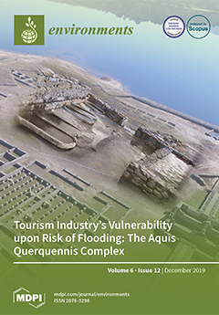
Cover Story (view full-size image): The present investigation consists of a preliminary analysis of a historical–heritage tourism resource vulnerability to flooding. The resource analyzed is the roman archaeological complex Aquis Querquennis (Bande, Ourense, Spain), a relevant tourist attraction that has been recognized as a cultural interest resource (CIT). The complex consists of three main parts: an ancient military campsite, a travelers’ hostel, and thermal baths (restored and improved in 2008), and it is in a natural environment. However, every year, it suffers floods, which influences the number of visits and leads to a need for continuous care of the resource. View this paper.
  • Issues are regarded as officially published after their release is announced to the table of contents alert mailing list.
  • You may sign up for e-mail alerts to receive table of contents of newly released issues.
  • PDF is the official format for papers published in both, html and pdf forms. To view the papers in pdf format, click on the "PDF Full-text" link, and use the free Adobe Reader to open them.
Order results
Result details
Select all
Export citation of selected articles as:
14 pages, 1342 KiB  
Article
Occupational Exposure on Board Fishing Vessels: Risk Assessments of Biomechanical Overload, Noise and Vibrations among Worker on Fishing Vessels in Southern Italy
by Francesca Mansi, Enza Sabrina Silvana Cannone, Antonio Caputi, Luigi De Maria, Leonardo Lella, Domenica Cavone and Luigi Vimercati
Environments 2019, 6(12), 127; https://doi.org/10.3390/environments6120127 - 17 Dec 2019
Cited by 18 | Viewed by 6436
Abstract
Sea fishing is one of the sectors with the highest risk of illness and work-related accidents. The purpose of the study is to evaluate the exposure of fishing workers to three major risks: biomechanical overload, noise, and whole-body vibrations. We used common methods [...] Read more.
Sea fishing is one of the sectors with the highest risk of illness and work-related accidents. The purpose of the study is to evaluate the exposure of fishing workers to three major risks: biomechanical overload, noise, and whole-body vibrations. We used common methods and measurement tools in the field: observational video analysis, questionnaires, and direct measurement. Noise and vibrations levels were measured aboard five boats belonging to the main fishing communities of Southern Italy. The random sample consisted of 310 workers, of whom 108 agreed to complete a questionnaire to collect data on the perception of occupational risk and self-perception of health conditions. We found that fishermen had a high prevalence of osteoarticular pathologies (42%) and that the biomechanical overload risk is mainly related to handling manual loads. Furthermore, the results indicate that the levels of weekly noise exposure exceed the exposure limit value of 87 decibel A (dBA) for fishing workers, and that the most noisiest area is the engine room. Exposure levels to whole-body vibrations were below <0.5 m/s2. Knowledge on occupational hazards and health effects in the fisheries sector should be used to develop ship technology, raise awareness of the correct use of personal protective equipment, and improve health surveillance of these workers. Full article
Show Figures

Figure 1

14 pages, 4693 KiB  
Article
Survey on Electromagnetic Interference in Weather Radars in Northwestern Italy
by Mattia Vaccarono, Chandra V. Chandrasekar, Renzo Bechini and Roberto Cremonini
Environments 2019, 6(12), 126; https://doi.org/10.3390/environments6120126 - 16 Dec 2019
Cited by 12 | Viewed by 7773
Abstract
Radio Frequency Interference (RFI) is one of the main issues in weather radar community. Data quality and post-processing algorithm, such as quantitative precipitation estimation and hydrometeor classification, are often affected by interferences. C-band radars share their operational frequency band with Radio Local Area [...] Read more.
Radio Frequency Interference (RFI) is one of the main issues in weather radar community. Data quality and post-processing algorithm, such as quantitative precipitation estimation and hydrometeor classification, are often affected by interferences. C-band radars share their operational frequency band with Radio Local Area Network (RLAN) and Wireless Area Network (WLAN), which may cause harmful interferences in radar systems. Nowadays, in northwestern Italy, the X-band weather radar managed by Arpa Piemonte is also receiving interfering signals. This work aims to introduce the RFIs phenomena affecting both C-band and X-band weather radars in Piemonte region, Italy. A preliminary method to detect the interfering sources at C-band is discussed, cross-checking data available in the regional database of electromagnetic sources and in-field measurements. A six-day measurement campaign was performed using the X-band radar as receiving antenna to collect an extensive dataset of interfering signals. The polarimetric features of the acquired RFI dataset are presented. The X-band RFIs show a day–night pattern, likely caused by human-related activities. The growth of wireless telecommunication systems, such as HiperLAN in northwestern Italy, and the continuous demand of electromagnetic spectrum portions make the understanding of electromagnetic interferences in weather radars the primary concern to ensure the data quality. Full article
(This article belongs to the Special Issue Physical Agents: Measurement Methods, Modelling and Mitigations)
Show Figures

Figure 1

14 pages, 1185 KiB  
Article
Characterizing the Spatial Distribution of Eragrostis Curvula (Weeping Lovegrass) in New Jersey (United States of America) Using Logistic Regression
by Kikombo Ilunga Ngoy and Daniela Shebitz
Environments 2019, 6(12), 125; https://doi.org/10.3390/environments6120125 - 15 Dec 2019
Cited by 4 | Viewed by 4840
Abstract
The increasing spread of invasive plants has become a critical driver of global environmental change. Once established, invasive species are often impossible to eradicate. Therefore, predicting the spread has become a key element in fighting invasive species. In this study, we examined the [...] Read more.
The increasing spread of invasive plants has become a critical driver of global environmental change. Once established, invasive species are often impossible to eradicate. Therefore, predicting the spread has become a key element in fighting invasive species. In this study, we examined the efficiency of a logistic regression model as a tool to identify the spatial occurrence of an invasive plant species. We used Eragrostis curvula (Weeping Lovegrass) as the dependent variable. The independent variables included temperature, precipitation, soil types, and the road network. We randomly selected 68 georeferenced points to test the goodness of fit of the logistic regression model to predict the presence of E. curvula. We validated the model by selecting an additional 68 random points. Results showed that the probability to successfully predict the presence of E. Curvula was 82.35%. The overall predictive accuracy of the model for the presence or absence of E. Curvula was 80.88%. Additional tests including the Chi-square test, the Hosmer–Lemeshow (HL) test, and the area under the curve (AUC) values, all indicated that the model was the best fit. Our results showed that E. curvula was associated with the identified variables. This study suggests that the logistic regression model can be a useful tool in the identification of invasive species in New Jersey. Full article
Show Figures

Figure 1

12 pages, 295 KiB  
Article
Error Models for the Kinetic Evaluation of Chemical Degradation Data
by Johannes Ranke and Stefan Meinecke
Environments 2019, 6(12), 124; https://doi.org/10.3390/environments6120124 - 10 Dec 2019
Cited by 3 | Viewed by 6652
Abstract
In the kinetic evaluation of chemical degradation data, degradation models are fitted to the data by varying degradation model parameters to obtain the best possible fit. Today, constant variance of the deviations of the observed data from the model is frequently assumed (error [...] Read more.
In the kinetic evaluation of chemical degradation data, degradation models are fitted to the data by varying degradation model parameters to obtain the best possible fit. Today, constant variance of the deviations of the observed data from the model is frequently assumed (error model “constant variance”). Allowing for a different variance for each observed variable (“variance by variable”) has been shown to be a useful refinement. On the other hand, experience gained in analytical chemistry shows that the absolute magnitude of the analytical error often increases with the magnitude of the observed value, which can be explained by an error component which is proportional to the true value. Therefore, kinetic evaluations of chemical degradation data using a two-component error model with a constant component (absolute error) and a component increasing with the observed values (relative error) are newly proposed here as a third possibility. In order to check which of the three error models is most adequate, they have been used in the evaluation of datasets obtained from pesticide evaluation dossiers published by the European Food Safety Authority (EFSA). For quantitative comparisons of the fits, the Akaike information criterion (AIC) was used, as the commonly used error level defined by the FOrum for the Coordination of pesticide fate models and their USe(FOCUS) is based on the assumption of constant variance. A set of fitting routines was developed within the mkin software package that allow for robust fitting of all three error models. Comparisons using parent only degradation datasets, as well as datasets with the formation and decline of transformation products showed that in many cases, the two-component error model proposed here provides the most adequate description of the error structure. While it was confirmed that the variance by variable error model often provides an improved representation of the error structure in kinetic fits with metabolites, it could be shown that in many cases, the two-component error model leads to a further improvement. In addition, it can be applied to parent only fits, potentially improving the accuracy of the fit towards the end of the decline curve, where concentration levels are lower. Full article
(This article belongs to the Special Issue Environmental Risk Assessment of Chemical Products)
Show Figures

Figure 1

16 pages, 4571 KiB  
Article
A Simple Approach of Groundwater Quality Analysis, Classification, and Mapping in Peshawar, Pakistan
by Syed Adnan, Javed Iqbal, Matti Maltamo, Muhammad Suleman Bacha, Asfandyar Shahab and Ruben Valbuena
Environments 2019, 6(12), 123; https://doi.org/10.3390/environments6120123 - 7 Dec 2019
Cited by 13 | Viewed by 8714
Abstract
Groundwater is an important source of water for drinking, agriculture, and other household purposes, but high population growth, industrialization, and lack of oversight on environmental policies and implementation have not only degraded the quality but also stressed the quantity of this precious source [...] Read more.
Groundwater is an important source of water for drinking, agriculture, and other household purposes, but high population growth, industrialization, and lack of oversight on environmental policies and implementation have not only degraded the quality but also stressed the quantity of this precious source of water. Many options existed, but this study evaluated, classified, and mapped the quality of groundwater used for potable consumption with a simple approach in an urban area (Peshawar valley) of Pakistan. More than 100 groundwater samples were collected and analyzed for physio-chemical parameters in a laboratory. Hierarchal clustering analysis (HCA) and classification and regression tree (CART) analysis were sequentially applied to produce potential clusters/groups (groundwater quality classes), extract the threshold values of the clusters, classify and map the groundwater quality data into meaningful classes, and identify the most critical parameters in the classification. The HCA produced six distinct potential clusters. We found a high correlation of electrical conductivity with t o t a l   h a r d n e s s ( R 2 =   0.72 ), a l k a l i n i t y ( R 2 =   0.59 ) and c h l o r i d e   ( R 2 =   0.64 ) , and, t o t a l   h a r d n e s s with c h l o r i d e ( R 2 = 0.62), and a l k a l i n i t y ( R 2 = 0.51). The CART analysis conclusively identified the threshold values of the six classes and showed that t o t a l   h a r d n e s s was the most critical parameter in the classification. The majority of the groundwater was either with worse quality or good quality, and only a few areas had the worst groundwater quality. This study presents a simple tool for the classification of groundwater quality based on several aesthetic constituents and can assist decision makers develop and support policies and/or regulations to manage groundwater resources. Full article
(This article belongs to the Special Issue Groundwater Quality and Groundwater Vulnerability Assessment)
Show Figures

Figure 1

15 pages, 3239 KiB  
Article
Tourism Industry’s Vulnerability upon Risk of Flooding: The Aquis Querquennis Complex
by Noelia Araújo Vila, Diego R. Toubes and Jose Antonio Fraiz Brea
Environments 2019, 6(12), 122; https://doi.org/10.3390/environments6120122 - 28 Nov 2019
Cited by 5 | Viewed by 11205
Abstract
Thermal baths are the main touristic attraction of Ourense (Galicia, Spain). Therefore, protecting and potentializing the resources related to this type of tourism is essential for the province. Most of these resources are located by the banks or nearby rivers, which makes them [...] Read more.
Thermal baths are the main touristic attraction of Ourense (Galicia, Spain). Therefore, protecting and potentializing the resources related to this type of tourism is essential for the province. Most of these resources are located by the banks or nearby rivers, which makes them particularly susceptible to flooding, a very common phenomenon throughout the province. In this context, vulnerability analysis, and particularly flooding damage evaluation, are of utmost importance to this area. Considering this scenario, the present study consists of a preliminary analysis of a historical-heritage tourism resource’s vulnerability to flooding. To this end, the study examines the visitation patterns to the Aquis Querquennis complex (Bande, Ourense, Spain), which is located by the banks of the As Conchas reservoir, and the water levels of said reservoir. The complex is a touristic resource with great historical value. Apart from the thermal baths, it encompasses a military campsite and a hostel. The Roman complex attracts a constant tourist flow, which has a positive socioeconomic impact to the area. The analysis showed that there is a correlation between the number of visits and flooding patterns. Increased levels of water are a hinderance for those willing to access the attraction. Consequently, there is a negative relationship between water level and number of visitors. Full article
Show Figures

Figure 1

14 pages, 1155 KiB  
Article
Seasonal Emergence and Historical Contaminant Exposure of Cave Myotis (Myotis velifer) in Central Texas and Current Status of the Population
by Tarisha A. Land, Donald R. Clark, Jr., Charles E. Pekins and Thomas E. Lacher, Jr.
Environments 2019, 6(12), 121; https://doi.org/10.3390/environments6120121 - 20 Nov 2019
Cited by 2 | Viewed by 4658
Abstract
We examined the emergence patterns of Myotis velifer in central Texas in 2000 and assessed exposure to pesticide residues. We collected and analyzed guano from three caves for pesticide residues. In addition, bat carcasses were sampled from an active colony of cave myotis [...] Read more.
We examined the emergence patterns of Myotis velifer in central Texas in 2000 and assessed exposure to pesticide residues. We collected and analyzed guano from three caves for pesticide residues. In addition, bat carcasses were sampled from an active colony of cave myotis (Myotis velifer) in Shell Mountain. Organochlorine residue concentrations were highest in guano from the Egypt and Tippit Caves, whereas organophosphate concentrations were highest in Shell Mountain guano. Residue concentrations of organochlorines and metals in guano and carcasses collected from the three caves are considered low and probably of no biological concern. The study was one of very few to demonstrate the presence of OPs, including 18 different detectable compounds in the two most recent samples of bat guano. Comparisons between spring and fall guano samples from Shell Mountain suggest that HCB (hexachlorobenzene), total chlordanes, dieldrin, endrin, endosulfan II, p,p’-DDE (Dichloro-2,2-bis(p-chlorophenyl) ethylene), and o,p’-DDT (Dichlorodiphenyltrichloroethane) accumulated while bats were absent from the caves at Fort Hood. Lindane appeared to be the only chemical that increased while the bats were present at the site. Organochlorine concentrations in carcasses were generally lowest in lactating females and higher in nursing juveniles. The pattern of emergence coincides with the peak of agricultural activities, therefore, bats forage at a time when the insect pests are most abundant, but also potential to exposure to agricultural chemicals is highest. The current status of the population, however, remains stable in spite of the history of exposure. Full article
(This article belongs to the Special Issue Emerging Contaminants in Wildlife Toxicology)
Show Figures

Figure 1

Previous Issue
Next Issue
Back to TopTop