A Review of the Available Land Cover and Cropland Maps for South Asia


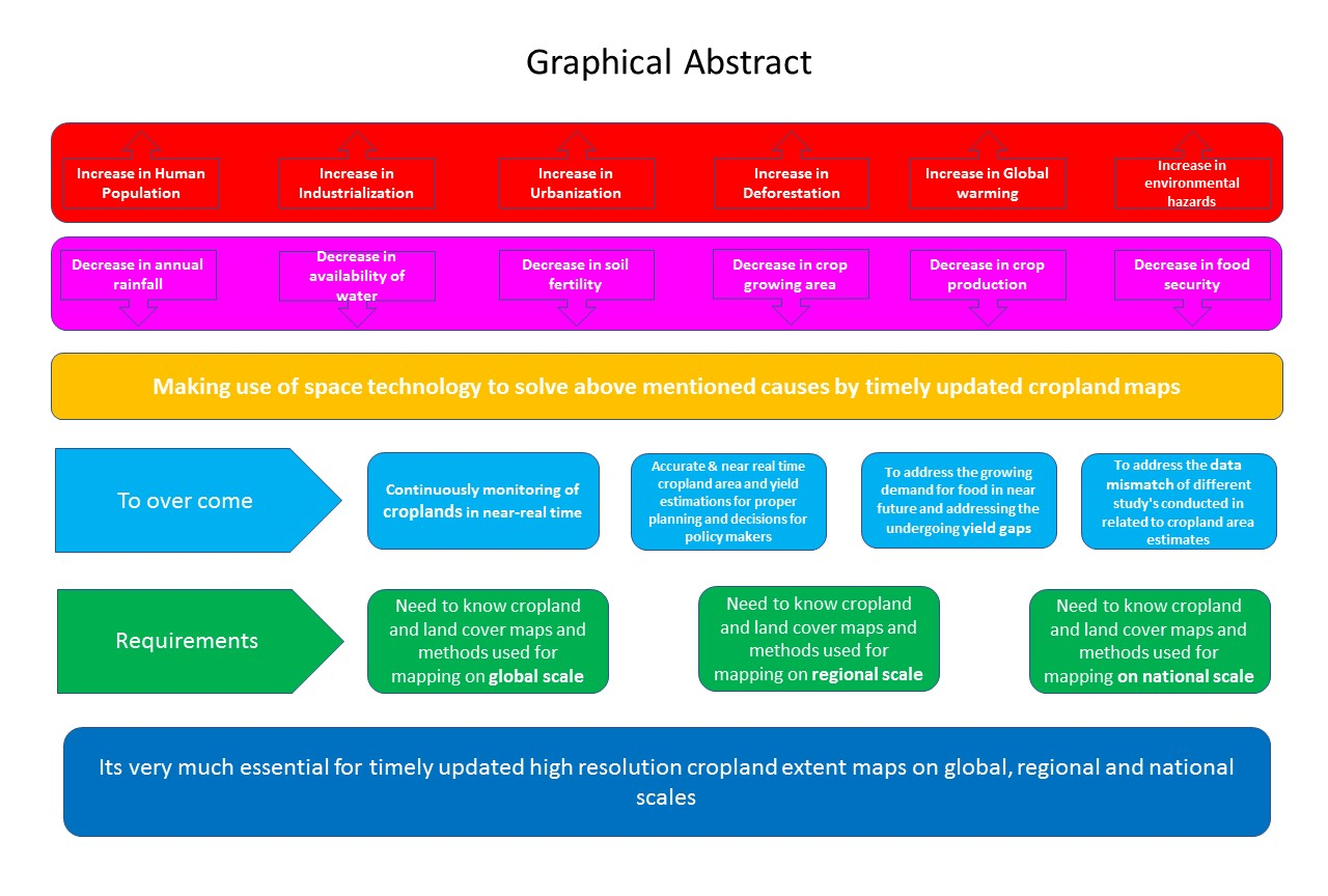
Abstract
:
1. Introduction
1.1. Croplands
1.2. Policy
1.3. Yield Gaps
1.4. Data Mismatches
2. Currently Available Satellite-Based Global, Regional, and National Land-Cover and Cropland Maps at Different Resolutions
2.1. Currently Available Satellite-Based Global Land Cover and Croplands Maps
2.1.1. International Geosphere Biosphere Programme Data and Information Systems (IGBP-DIS)
2.1.2. University of Maryland Global Land Cover (UMd-GLC)
2.1.3. Global Land Cover SHARE (GLC-SHARE)
2.1.4. Global Land Cover Map for the Year 2000 (GLC2000)
2.1.5. MODIS-Based MCD12Q1
2.1.6. Global Major Crops Distribution Map
2.1.7. Agricultural Lands in the Year 2000 (M3-Cropland and M3-Pasture Data)
2.1.8. Collection 5 MODIS Global Land Cover Type Product
2.1.9. Global Land Cover by National Mapping Organizations (GLCNMO)
2.1.10. The Centre for Sustainability and the Global Environment (SAGE)
2.1.11. History Database of the Global Environment (HYDE)
2.1.12. Global Irrigated Area Map (GIAM)
2.1.13. Global Map of Rainfed Cropland Areas (GMRCA)
2.1.14. IIASA-IFPRI Cropland Percentage Map
2.1.15. Monthly Irrigated and Rain-Fed Crop Areas around the Year 2000 (MIRCA2000)
2.1.16. GlobCover Global Land Cover Map
2.1.17. Global Cropland Extent Map
2.1.18. A Unified Global Cropland Layer
2.1.19. Finer Resolution Observation and Monitoring of Global Land Cover (FROM-GLC)
2.1.20. Fine Resolution Observation and Monitoring of Global Land Cover (FROM-GLC-SEG)
2.1.21. Global Land Cover (GLC)
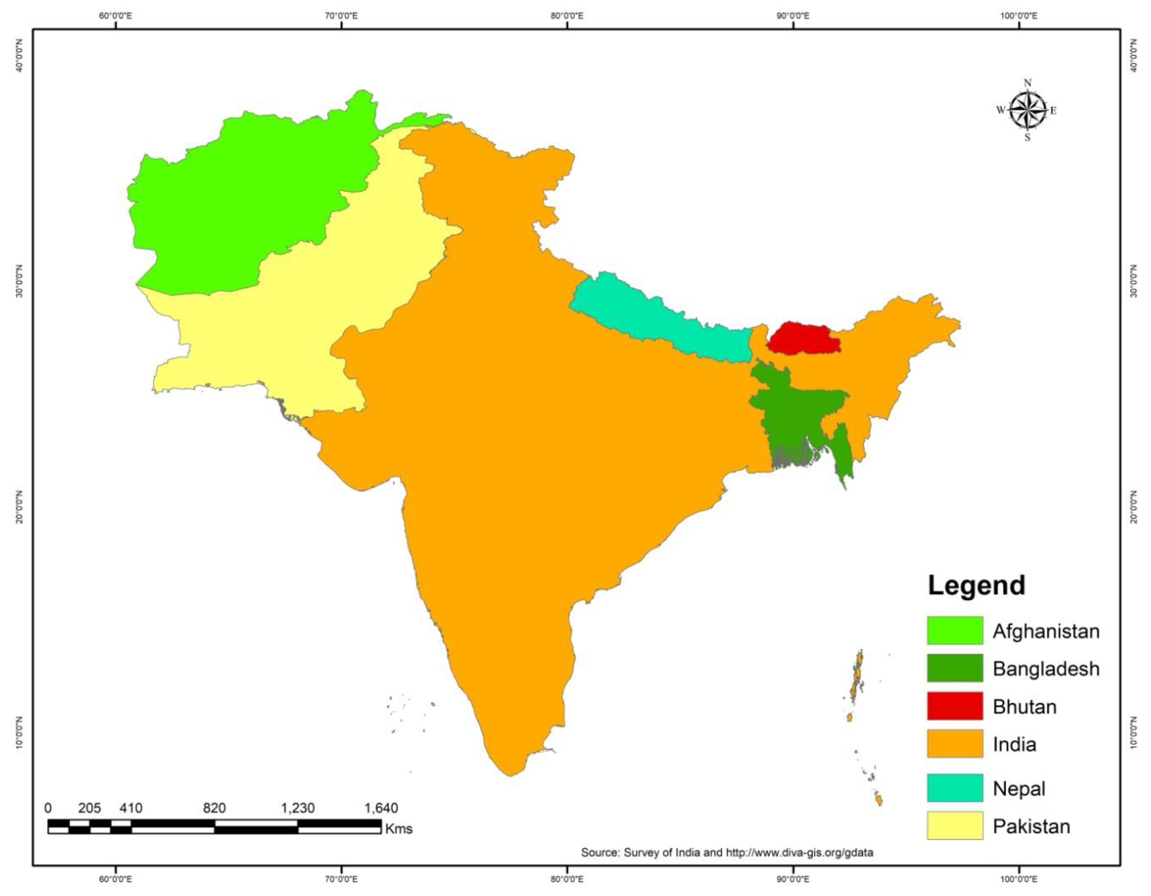
2.2. Currently Available Regional Land Cover and Cropland Maps of South Asia
2.2.1. Rice Map of South Asia of the Year 2010
2.2.2. Rice Map of South Asia of the Years1993–1996
2.2.3. Rice Map of South Asia of the Year 2002
2.3. Currently Available Satellite-Based National Land Cover and Cropland Maps within South Asia
2.3.1. Afghanistan
2.3.2. Bhutan
2.3.3. Bangladesh
2.3.4. India
2.3.5. Nepal
2.3.6. Pakistan
3. Discussion
4. Conclusions
Author Contributions
Funding
Acknowledgments
Conflicts of Interest
References
- Agriculture Development Bank Report on South Asia. 2013. Available online: https://www.adb.org/documents/adb-annual-report-2013 (accessed on 17 January 2017).
- FAO. FAOSTAT Agricultural Data. 2005. Available online: http://www.fao.org/faostat/en/#data/QC (accessed on 9 February 2017).
- FAO. How to Feed the World in 2050. Report from the High-Level Expert Forum. 2009. Available online: http://www.fao.org/faostat/en/#data/QC (accessed on 3 January 2017).
- FAO. 2008. Available online: http://www.fao.org/faostat/en/#data/QC (accessed on 21 December 2016).
- FAO. FAOSTAT Agricultural Data. 2010. Available online: http://www.fao.org/faostat/en/#data/QC (accessed on 21 November 2016).
- Roberts, L. 9 Billion? Science 2011, 333, 540–543. [Google Scholar] [CrossRef] [PubMed]
- Alexandratos, N.; Bruinsma, J. World Agriculture towards 2030/2050 in Proceedings of the 2012 Revision; ESA Working Paper No 12-03 2012; Food and Agriculture Organization of the United Nations: Rome, Italy, 2012. [Google Scholar]
- FAO. FAOSTAT. 2012. Available online: http://www.fao.org/faostat/en/#data/QC (accessed on 17 February 2017).
- Wu, B.; Gommes, R.; Zhang, M.; Zeng, H.; Yan, N.; Zou, W.; Zheng, Y.; Zhang, N.; Chang, S.; Xing, Q.; et al. Global crop monitoring: A satellite-based hierarchical approach. Remote Sens. 2015, 7, 3907–3933. [Google Scholar] [CrossRef]
- Hannerz, F.; Lotsch, A. Assessment of remotely sensed and statistical inventories of African agricultural fields. Int. J. Remote Sens. 2008, 29, 3787–3804. [Google Scholar] [CrossRef]
- Vancutsem, C.; Marinho, E.; Kayitakire, F.; See, L.; Fritz, S. Harmonizing and Combining Existing Land Cover/Land Use Datasets for Cropland Area Monitoring at the African Continental Scale. Remote Sens. 2013, 5, 19–41. [Google Scholar] [CrossRef] [Green Version]
- Parihar, J.S.; Markand, O.P. Agriculture and hydrology applications of remote sensing. Proc. SPIE Int. Soc. Opt. Eng. 2006, 6411, 641101–641102. [Google Scholar]
- Lobell, D.; Bala, G.; Duffy, P. Biogeophysical impacts of cropland management changes on climate. Geophys. Res. Lett. 2006, 33, 1–4. [Google Scholar] [CrossRef]
- Foley, J.A.; Ramankutty, N.; Brauman, K.A.; Cassidy, E.S.; Gerber, J.S.; Johnston, M.; Mueller, N.D.; O’Connell, C.; Ray, D.K.; West, P.C.; et al. Solutions for a cultivated planet. Nature 2011, 478, 337–342. [Google Scholar] [CrossRef] [PubMed] [Green Version]
- Gordon, L.J.; Steffen, W.; Jonsson, B.F.; Folke, C.; Falkenmark, M.; Johansen, A. Human Modification of Global Water Vapor Flows from the Land Surface. Proc. Natl. Acad. Sci. USA 2005, 102, 7612–7617. [Google Scholar] [CrossRef] [PubMed]
- Gong, P. China needs no foreign help to feed itself. Nature 2011, 474, 7. [Google Scholar] [CrossRef] [PubMed]
- Thenkabail, P.S.; Hanjra, M.A.; Dheeravath, V.; Gumma, M. A holistic view of global croplands and their water use for ensuring global food security in the 21st century through advanced remote sensing and non-remote sensing approaches. Remote Sens. 2010, 2, 211–261. [Google Scholar] [CrossRef] [Green Version]
- Yu, L.; Wang, J.; Clinton, N.; Xin, Q.; Zhong, L.; Chen, Y.; Gong, P. FROM-GC: 30 m global cropland extent derived through multisource data integration. Int. J. Digit. Earth 2013, 6, 521–533. [Google Scholar] [CrossRef]
- Funk, C.C.; Brown, M.E. Declining global per capita agricultural production and warming oceans threaten food security. Food Secur. 2009, 1, 271–289. [Google Scholar] [CrossRef] [Green Version]
- Linda, S.; Steffen, F.; Liangzhi, Y.; Ramankutty, N.; Herrero, M.; Justice, C.; Becker-Reshef, I.; Thornton, P.; Erb, K.; Gong, P.; et al. Improved global cropland data as an essential ingredient for food security. Glob. Food Sec. 2015, 4, 37–45. [Google Scholar] [CrossRef] [Green Version]
- Tilman, D.; Balzer, C.; Hill, J.; Befort, B.L. Global Food Demand and the Sustainable Intensification of Agriculture. Proc. Natl. Acad. Sci. USA 2011, 108, 20260–20264. [Google Scholar] [CrossRef] [PubMed]
- Van Wart, J.; Kersebaum, K.C.; Peng, S.; Milner, M.; Cassman, K.G. Estimating crop yield potential at regional to national scales. Field Crops Res. 2013, 143, 34–43. [Google Scholar] [CrossRef]
- Grassini, P.; van Bussel, L.G.J.; Van Wart, J.; Wolf, J.; Claessens, L.; Yang, H.; Boogaard, H.; de Groot, H.; van Ittersum, M.K.; Cassman, K.G. How good is good enough? Data requirements for reliable crop yield simulations and yield-gap analysis. Field Crops Res. 2015, 177, 49–63. [Google Scholar] [CrossRef] [Green Version]
- Van Bussel, L.G.J.; Grassini, P.; van Wart, J.; Wolf, J.; Claessens, L.; Yang, H.; Boogaard, H.; de Groot, H.; Saito, K.; Cassman, K.G.; et al. From field to atlas: Upscaling of location-specific yield gap estimates. Field Crops Res. 2015, 177, 98–108. [Google Scholar] [CrossRef] [Green Version]
- Thenkabail, P.S.; Biradar, C.M.; Noojipady, P.; Dheeravath, V.; Li, Y.; Velpuri, M.; Gumma, M.; Gangalakunta, O.R.P.; Turral, H.; Cai, X.; et al. Global irrigated area map (GIAM), derived from remote sensing, for the end of the last millennium. Int. J. Remote Sens. 2009, 30, 3679–3733. [Google Scholar] [CrossRef]
- Tilman, D.; Cassman, K.G.; Matson, P.A.; Naylor, R.; Polasky, S. Agricultural Sustainability and Intensive Production Practices. Nature 2002, 418, 671–677. [Google Scholar] [CrossRef] [PubMed]
- Smith, P.; Gregory, P.J.; van Vuuren, D.; Obersteiner, M.; Havlik, P.; Rounsevell, M.; Woods, J.; Stehfest, E.; Bellarby, J. Competition for Land. Philos. Trans. R. Soc. Lond. B, Biol. Sci. 2010, 365, 2941–2957. [Google Scholar] [CrossRef] [PubMed]
- Linard, C.; Gilbert, M.; Tatem, A.J. Assessing the use of global land cover data for guiding large area population distribution modelling. GeoJournal 2010, 76, 525–538. [Google Scholar] [CrossRef] [PubMed] [Green Version]
- Quaife, T.; Quegan, S.; Disney, M.; Lewis, P.; Lomas, M.; Woodward, F.I. Impact of land cover uncertainties on estimates of biospheric carbon fluxes. Glob. Biogeochem. Cycles 2008, 22, 1–12. [Google Scholar] [CrossRef]
- Fritz, S.; You, L.; Bun, A.; See, L.; McCallum, I.; Schill, C.; Perger, C.; Liu, J.; Hansen, M.; Obersteiner, M. Cropland for sub-Saharan Africa: A synergistic approach using five land cover data sets. Geophys. Res. Lett. 2011, 38, L04404. [Google Scholar] [CrossRef]
- Arino, O.; Bicheron, P.; Achard, F.; Latham, J.; Witt, R.; Weber, J.L. The most detailed portrait of Earth. Eur. Space Agency 2008, 136, 25–31. [Google Scholar]
- Bontemps, S.; Defourny, P.; van Bogaert, E.; Arino, O.; Kalogirou, V.; Perez, J.R. GLOBCOVER 2009: Products description and validation report. UCL Eur. Space Agency 2011, 2, 53. Available online: http://doi.pangaea.de/10013/epic.39884.d016 (accessed on 14 April 2017).
- Foley, J.A.; DeFries, R.; Asner, G.P.; Barford, C.; Bonan, G.; Carpenter, S.R.; Chapin, F.S.; Coe, M.T.; Daily, G.C.; Gibbs, H.K.; et al. Global consequences of land use. Science 2005, 309, 570–574. [Google Scholar] [CrossRef] [PubMed]
- Ramankutty, N.; Evan, A.T.; Monfreda, C.; Foley, J.A. Farming the Planet: 1. Geographic Distribution of Global Agricultural Lands in the Year 2000. Glob. Biogeochem. Cycles 2008, 22, 1–19. [Google Scholar] [CrossRef]
- Tateishi, R.; Uriyangqai, B.; Al-Bilbisi, H.; Ghar, A.; Tsend-Ayush, J.; Kobayashi, T.; Kasimu, A.; Hoan, N.T.; Shalaby, A.; Alsaaideh, B.; et al. Production of global land cover data GLCNMO. Int. J. Digit. Earth 2011, 4, 2249. [Google Scholar] [CrossRef]
- Wulder, M.A.; Masek, J.G.; Cohen, W.B.; Loveland, T.R.; Woodcock, C.E. Opening the Archive: How Free Data Has Enabled the Science and Monitoring Promise of Landsat. Remote Sens. Environ. 2012, 122, 2–10. [Google Scholar] [CrossRef]
- Loveland, T.R.; Reed, B.C.; Brown, J.F.; Ohlen, D.O.; Zhu, Z.; Yang, L.; Merchant, J.W. Development of a Global Land Cover Characteristics Database and IGBP DIS Cover from 1 km AVHRR Data. Int. J. Remote Sens. 2000, 21, 1303–1330. [Google Scholar] [CrossRef]
- Hansen, M.; DeFries, R.; Townshend, J.R.G.; Sohlberg, R. Global land cover classification at 1km resolution using a decision tree classifier. Int. J. Remote Sens. 2000, 21, 1331–1365. [Google Scholar] [CrossRef]
- Latham, J.; Cumani, R.; Rosati, I.; Bloise, M. Global Land Cover SHARE (GLC-SHARE) Database Beta-Release Version 1.0; FAO: Rome, Italy, 2014. [Google Scholar]
- Bartholomé, E.; Belward, A. GLC2000: A new approach to global land cover mapping from Earth observation data. Int. J. Remote Sens. 2005, 26, 1959–1977. [Google Scholar] [CrossRef]
- Friedl, M.A.; McIver, D.K.; Hodges, J.C.F.; Zhang, X.Y.; Muchoney, D.; Strahler, A.H.; Woodcock, C.E.; Gopal, S.; Schneider, A.; Cooper, A.; et al. Global land cover mapping from MODIS: Algorithms and early results. Remote Sens. Environ. 2002, 83, 287–302. [Google Scholar] [CrossRef]
- Leff, B.; Ramankutty, N.; Foley, J.A. Geographic distribution of major crops across the world. Glob. Biogeochem. Cycles 2004, 18, GB1009. [Google Scholar] [CrossRef]
- Monfreda, C.; Ramankutty, N.; Foley, J.A. Farming the Planet: 2. Geographic Distribution of Crop Areas, Yields, Physiological Types, and Net Primary Production in the Year 2000. Glob. Food Sec. 2008, 22, 567–568. [Google Scholar] [CrossRef]
- Friedl, M.A.; Sulla-Menashe, D.; Tan, B.; Schneider, A.; Ramankutty, N.; Sibley, A.; Huang, X. MODIS Collection 5 global land cover: Algorithm refinements and characterization of new datasets. Remote Sens. Environ. 2010, 114, 168–182. [Google Scholar] [CrossRef]
- Goldewijk, K.K.; Beusen, A.; van Drecht, G.; de Vos, M. The HYDE 3.1 Spatially Explicit Database of Human-induced Global Land-use Change over the Past 12,000 Years. Glob. Ecol. Biogeogr. 2010, 20, 73–86. [Google Scholar] [CrossRef]
- Biradar, C.M.; Thenkabail, P.S.; Noojipady, P.; Li, Y.; Dheeravath, V.; Turral, H.; Velpuri, M.; Gumma, M.K.; Gangalakunta, O.R.P.; Cai, X.L.; et al. A global map of rainfed cropland areas (GMRCA) at the end of last millennium using remote sensing. Int. J. Appl. Earth Obs. Geoinf. 2009, 11, 114–129. [Google Scholar] [CrossRef]
- Fritz, S.; See, L.; McCallum, I.; You, L.; Bun, A.; Moltchanova, E.; Duerauer, M.; Albrecht, F.; Schill, C.; Perger, C.; et al. Mapping global cropland and field size. Glob. Chang. Biol. 2015, 21, 1980–1992. [Google Scholar] [CrossRef] [PubMed] [Green Version]
- Portmann, F.; Siebert, S.; Doll, P. MIRCA2000—Global monthly irrigated and rainfed crop areas around the year 2000: A new high-resolution data set for agricultural and hydrological modelling. Glob. Biogeochem. Cycles 2010, 24, GB1011. [Google Scholar] [CrossRef]
- Pittman, K.; Hansen, M.C.; Becker-Reshef, I.; Potapov, P.V.; Justice, C.O. Estimating Global Cropland Extent with Multi-Year MODIS Data. Rem. Sens. 2010, 2, 1844–1863. [Google Scholar] [CrossRef]
- Waldner, F.S.; Fritz, A.; Gregorio, D.; Defourny, P. Mapping priorities to focus cropland mapping activities: Fitness assessment of existing global, regional and national cropland maps. Remote Sens. 2015, 7, 7959–7986. [Google Scholar] [CrossRef] [Green Version]
- Gong, P.; Wang, J.; Yu, L.; Zhao, Y.C.; Zhao, Y.Y.; Liang, L.; Niu, Z.G.; Huang, X.M.; Fu, H.H.; Liu, S.; et al. Finer resolution observation and monitoring of global land cover: First mapping results with Landsat TM and ETM+ data. Int. J. Remote Sens. 2013, 34, 2607–2654. [Google Scholar] [CrossRef]
- Yu, L.; Wang, J.; Gong, P. Improving 30 m global land-cover map FROM-GLC with time series MODIS and auxiliary data sets: A segmentation-based approach. Int. J. Remote Sens. 2013, 34, 5851–5867. [Google Scholar] [CrossRef]
- Chen, J.; Chen, J.; Liao, A.; Cao, X.; Chen, L.; Chen, X.; He, C.; Han, G.; Peng, S.; Lu, M.; et al. Global land cover mapping at 30m resolution: A POK-based operational approach. ISPRS J. Photogramm. Remote Sens. 2015, 103, 7–27. [Google Scholar] [CrossRef]
- Fritz, S.; See, L.; McCallum, I.; Schill, C.; Obersteiner, M.; Velde, M.; van der Boettcher, H.; Havlík, P.; Achard, F. Highlighting continued uncertainty in global land cover maps for the user community. Environ. Res. Lett. 2011, 6, 044005. [Google Scholar] [CrossRef]
- Ozdogan, M.; Woodcock, C.E. Resolution dependent errors in remote sensing of cultivated areas. Remote Sens. Environ. 2006, 103, 203–217. [Google Scholar] [CrossRef]
- Gumma, M.K.; Nelson, A.; Thenkabail, P.S.; Singh, A.N. Mapping rice areas of South Asia using MODIS multitemporal data. J. Appl. Remote Sens. 2011, 5, 053547. [Google Scholar] [CrossRef] [Green Version]
- Gumma, M.K.; Thenkabail, P.S.; Teluguntla, P.; Rao, M.N.; Mohammed, A.I.; Whitbread, A.M. Mapping rice-fallow cropland areas for short-season grain legumes intensification in South Asia using MODIS 250 m time-series data. Int. J. Digit. Earth 2016, 9, 981–1003. [Google Scholar] [CrossRef] [Green Version]
- Huke, R.E.; Huke, E.H. Rice Area by Type of Culture: South, Southeast and East Asia; A Revised and Updated Data Base; IRRI: Manila, Philippines, 1997. [Google Scholar]
- Xiao, X.; Boles, S.; Frolking, S.; Li, C.; Babu, J.Y.; Salas, W.; Moore, B. Mapping paddy rice agriculture in South and Southeast Asia using multi-temporal MODIS images. Remote Sens. Environ. 2006, 100, 95–113. [Google Scholar] [CrossRef]
- FAO Global Cropland Definition. Available online: http://www.fao.org/docrep/005/Y4171E/Y4171E20.htm (accessed on 2 June 2018).
- Afghanistan Land Cover Mapping (ALCM). Strengthening Agricultural Economics, Market Information and Statistics Services in Afghanistan. Available online: http://www.glcn.org/activities/afg_lc_en.jsp (accessed on 3 January 2017).
- Sushil, P. Regional Land Cover Mapping of the Hindu Kush-Himalayan Using Satellite image: An Approach to Understand the Dynamics of Land Use and Land Cover Change. AARS 2002. Available online: http://a-a-r-s.org/aars/proceeding/ACRS2002/Papers/LU02-1.htm (accessed on 9 February 2017).
- Gumma, M.K.; Thenkabail, P.S.; Maunahan, A.; Islam, S.; Nelson, A. Mapping seasonal rice cropland extent and area in the high cropping intensity environment of Bangladesh using MODIS 500 m data for the year 2010. ISPRS J. Photogramm.Remote Sens. 2014, 9, 98–113. [Google Scholar] [CrossRef]
- Sreenivas, K.; Sekhar, N.S.; Saxena, M.; Paliwal, R.; Pathak, S.; Porwal, M.; Fyzee, M.; Kameswara Rao, S.V.C.; Wadodkar, M.; Anasuya, T.; et al. Estimating Inter-Annual Diversity of Seasonal Agricultural Area using Multi-Temporal Resourcesat Data. J. Environ. Manag. 2015, 161, 433–442. [Google Scholar] [CrossRef] [PubMed]
- Gumma, M.K.; Pyla, K.; Thenkabail, P.; Reddi, V.; Naresh, G.; Mohammed, I.; Rafi, I. Crop dominance mapping with IRS-P6 and MODIS 250-m time series data. Agriculture 2014, 4, 113–131. [Google Scholar] [CrossRef] [Green Version]
- Roy, P.S.; Behera, M.D.; Murthy, M.S.R.; Roy, A.; Singh, S.; Kushwaha, S.P.S.; Jha, C.S.; Sudhakar, S.; Joshi, P.K. New vegetation type map of India prepared using satellite remote sensing: Comparison with global vegetation maps and utilities. Int. J. Appl. Earth Obs. Geoinf. 2015, 39, 142–159. [Google Scholar] [CrossRef]
- Gumma, M.K.; Gauchan, D.; Nelson, A.D.; Pandey, S.; Rala, A. Temporal changes in rice-growing area and their impact on livelihood over a decade: A case study of Nepal. Agric. Ecosyst. Environ. 2011, 142, 382–392. [Google Scholar] [CrossRef]
- PAK-SCMS. Satellite Based Crop Monitoring System; Serial No 50; PAK-SCMS: Karachi, Pakistan, 2015; Volume 5.
- Lynch, J.; Maslin, M.; Balzter, H.; Sweeting, M. Sustainability: Choose satellites to monitor deforestation. Nature 2013, 496, 293–294. [Google Scholar] [CrossRef] [PubMed] [Green Version]


| Countries | Classes | 1962 | 1972 | 1982 | 1992 | 2002 | 2012 |
|---|---|---|---|---|---|---|---|
| India | Arable land | 156,700 | 160,186 | 163,246 | 162,706 | 160,432 | 156,542 |
| Permanent crops | 5700 | 4800 | 5500 | 7300 | 9600 | 12,800 | |
| Permanent meadows and pasture | 14,082 | 12,960 | 12,025 | 11,299 | 10,528 | 10,296 | |
| Agriculture land | 176,482 | 177,946 | 180,771 | 181,305 | 180,560 | 179,642 | |
| Afghanistan | Arable land | 7700 | 7910 | 7910 | 7910 | 7678 | 7785 |
| Permanent crops | 60 | 136 | 144 | 120 | 75 | 125 | |
| Permanent meadows and pasture | 30,000 | 30,000 | 30,000 | 30,000 | 30,000 | 30,000 | |
| Agriculture land | 37,760 | 38,046 | 38,054 | 38,030 | 37,753 | 37,910 | |
| Sri Lanka | Arable land | 577 | 822 | 857 | 905 | 936 | 1300 |
| Permanent crops | 945 | 1084 | 1000 | 1000 | 980 | 1000 | |
| Permanent meadows and pasture | 185 | 439 | 439 | 439 | 440 | 440 | |
| Agriculture land | 1707 | 2345 | 2296 | 2344 | 2356 | 2690 | |
| Bangladesh | Arable land | 8597 | 9133 | 9104 | 8609 | 8253 | 7678 |
| Permanent crops | 280 | 258 | 274 | 340 | 500 | 830 | |
| Permanent meadows and pasture | 600 | 600 | 600 | 600 | 600 | 600 | |
| Agriculture land | 9477 | 9991 | 9978 | 9549 | 9353 | 9120 | |
| Pakistan | Arable land | 30,690 | 30,340 | 33,140 | 29,920 | 31,220 | 30,240 |
| Permanent crops | 150 | 165 | 369 | 460 | 664 | 823 | |
| Permanent meadows and pasture | 5000 | 5000 | 5000 | 5000 | 5000 | 5000 | |
| Agriculture land | 35,840 | 35,505 | 38,509 | 35,380 | 35,884 | 36,063 | |
| Nepal | Arable land | 1806 | 2055 | 2291.60 | 2327.30 | 2335 | 2118 |
| Permanent crops | 25 | 27 | 29 | 37.9 | 120 | 208 | |
| Permanent meadows and pasture | 1722 | 1740 | 1786 | 1793 | 1786 | 1795 | |
| Agriculture land | 3553 | 3822 | 4106.60 | 4158.20 | 4241 | 4121 | |
| Bhutan | Arable land | 100 | 110 | 135 | 135 | 111 | 100.2 |
| Permanent crops | 13 | 16 | 18 | 19 | 19 | 12.4 | |
| Permanent meadows and pasture | 250 | 259 | 265 | 350 | 405 | 407 | |
| Agriculture land | 363 | 385 | 418 | 504 | 535 | 519.6 | |
| Maldives | Arable land | 2 | 3 | 3 | 3 | 3 | 3.9 |
| Permanent crops | 2 | 2 | 4 | 4 | 8 | 3 | |
| Permanent meadows and pasture | 1 | 1 | 1 | 1 | 1 | 1 | |
| Agriculture land | 5 | 6 | 8 | 8 | 12 | 7.9 |
| Sl No | Product | Spatial Resolution | Year | Satellite Data | Classification Method | Overall Accuracy | Reference |
|---|---|---|---|---|---|---|---|
| 1 | International Geosphere Biosphere Programme Data and Information Systems (IGBP-DIS) | 1 km | 1992–1993 | Advanced Very High-resolution Radiometer (AVHRR) | Unsupervised | 71.60% | [37] doi:10.1080/014311600210191 |
| 2 | University of Maryland Global Land Cover (UMd-GLC) | 1 km | 1992–1993 | Advanced Very High-resolution Radiometer (AVHRR) | Decision tree | 65% to 82% | [38] doi:10.1080/014311600210209 |
| 3 | Global Land Cover SHARE (GLC-SHARE) | 1 km | 2000–2014 | Globcover 2009, MODIS VCF 2010 andCropland database 2012 | Single harmonized database usinginternational standards | 80% | [39] http://www.fao.org/uploads/media/glc-share-doc.pdf |
| 4 | Global Land Cover Map for the Year 2000 (GLC2000) | 1 km | 2000 | SPOT-4 | Unsupervised | 68.60% | [40] doi:10.1080/01431160412331291297 |
| 5 | MODIS-Based MCD12Q1 | 1 km | 2002 | MODIS | Supervised (C4.5 algorithm) | 75% to 79% | [41] http://doi.org/10.1016/S0034-4257(02)00078-0 |
| 6 | Collection 5 MODIS Global Land Cover Type Product | 500 m | 2000 | MODIS | Decision tree | 75% | [44] http://dx.doi.org/10.1016/j.rse.2009.08.016 |
| 7 | Global Land Cover by National Mapping Organizations (GLCNMO) | 1 km | 2003 | MODIS | Supervised | 76.50% | [35] doi:10.1080/17538941003777521 |
| 8 | The Centre for Sustainability and the Global Environment (SAGE) | 10 km | 2000 | Boston University’s MODIS-derived land cover product (BU-MODIS) and the GLC2000 dataset | Merging | 90% | [34] doi:10.1029/2007GB002952 |
| 9 | IIASA-IFPRI Cropland Percentage Map | 1 km | 2005 | GlobCover 2005, MODIS v.5, regional maps, such as AFRICOVER, and national maps | Combining | 82.40% | [47] doi:10.1111/gcb.12838 |
| 10 | GlobCover Global Land Cover Map | 300 m | 2009 | MEdium Resolution Imaging Spectrometer (MERIS) | Supervised and Unsupervised | 67.50% | [32] http://doi.pangaea.de/10013/epic.39884.d016 |
| 11 | Global Cropland Extent Map | 250 m | 2000–2008 | MODIS | Supervised | 63% | [49] doi:10.3390/rs2071844 |
| 12 | A Unified Global Cropland Layer | 250 m | 2014 | National, Regional and Global land cover maps | Multi criteria approach | 82% | [50] doi:10.3390/rs70607959 |
| 13 | Finer Resolution Observation and Monitoring of Global Land Cover (FROM-GLC) | 30 m | 2010 | Landsat TM and ETM+ | Supervised | 64.90% | [51] https://doi.org/10.1080/01431161.2012.748992 |
| 14 | Fine Resolution Observation and Monitoring of Global Land Cover (FROM-GLC-seg) | 30 m | 2013 | Landsat TM, ETM+ and MODIS | Supervised (Image Segmentation) | 67.08% | [52] http://dx.doi.org/10.1080/01431161.2013.798055 |
| 15 | Global Land Cover (GLC) | 30 m | 2000–2010 | Landsat TM and ETM+ | Supervised | 80% | [53] doi:10.1016/j.isprsjprs.2014.09.002 |
| Sl No | Product | Spatial Resolution | Year | Satellite Data | Classification Method | Overall Accuracy | Reference |
|---|---|---|---|---|---|---|---|
| 1 | Rice map of South Asia of the year 2010 | 500 m | 2010 | MODIS | Supervised | 80% | [56] doi:10.1117/1.3619838 |
| 2 | Rainfed and irrigated rice-fallow cropland areas map of South Asia | 250 m | 2010–2011 | MODIS | Spectral matching technique | 82% | [57] doi:10.1080/17538947.2016.1168489 |
| 3 | Rice map of South Asia of the year 2002 | 500 m | 2002 | MODIS | Supervised | 85% | [60] doi:10.1016/j.rse.2005.10.004 |
| Sl No | Product | Spatial Resolution | Year | Satellite Data | Classification Method | Overall Accuracy | Reference |
|---|---|---|---|---|---|---|---|
| 1 | Land use/land cover map of Bhutan | 180 m | 1996–1999 | WiFs | Supervised | 83.10% | [62] http://a-a-r-s.org/aars/proceeding/ACRS2002/Papers/LU02-1.htm |
| 2 | Seasonal paddy rice map of Bangladesh | 500 m | 2000 | MODIS | Unsupervised | 78–90% | [63] doi:10.1016/j.isprsjprs.2014.02.007 |
| 3 | National-level agriculture land cover-type map of India | 56 m | 2005-2006 and 2011–2012 | AWiFS | Supervised | 87–96% | [64] doi:10.1016/j.jenvman.2014.10.031 |
| 4 | Crop dominance map in Krishna basin | 23.5 m and 250 m | 2005 | IRS-P6 and MODIS | Supervised | 67–100% | [65] https://doi.org/10.3390/agriculture4020113 |
| 5 | Land use/land cover map of Nepal | 180 m | 1996–1999 | WiFs | Supervised | 88% | [62] http://a-a-r-s.org/aars/proceeding/ACRS2002/Papers/LU02-1.htm |
© 2018 by the authors. Licensee MDPI, Basel, Switzerland. This article is an open access article distributed under the terms and conditions of the Creative Commons Attribution (CC BY) license (http://creativecommons.org/licenses/by/4.0/).
Share and Cite
Patil, P.; Gumma, M.K. A Review of the Available Land Cover and Cropland Maps for South Asia. Agriculture 2018, 8, 111. https://doi.org/10.3390/agriculture8070111
Patil P, Gumma MK. A Review of the Available Land Cover and Cropland Maps for South Asia. Agriculture. 2018; 8(7):111. https://doi.org/10.3390/agriculture8070111
Chicago/Turabian StylePatil, Prashant, and Murali Krishna Gumma. 2018. "A Review of the Available Land Cover and Cropland Maps for South Asia" Agriculture 8, no. 7: 111. https://doi.org/10.3390/agriculture8070111
APA StylePatil, P., & Gumma, M. K. (2018). A Review of the Available Land Cover and Cropland Maps for South Asia. Agriculture, 8(7), 111. https://doi.org/10.3390/agriculture8070111