
Drone-Image Based Fast Crack Analysis Algorithm Using Machine Learning for Highway Pavements †


1. Introduction
2. Methodology
- (1)
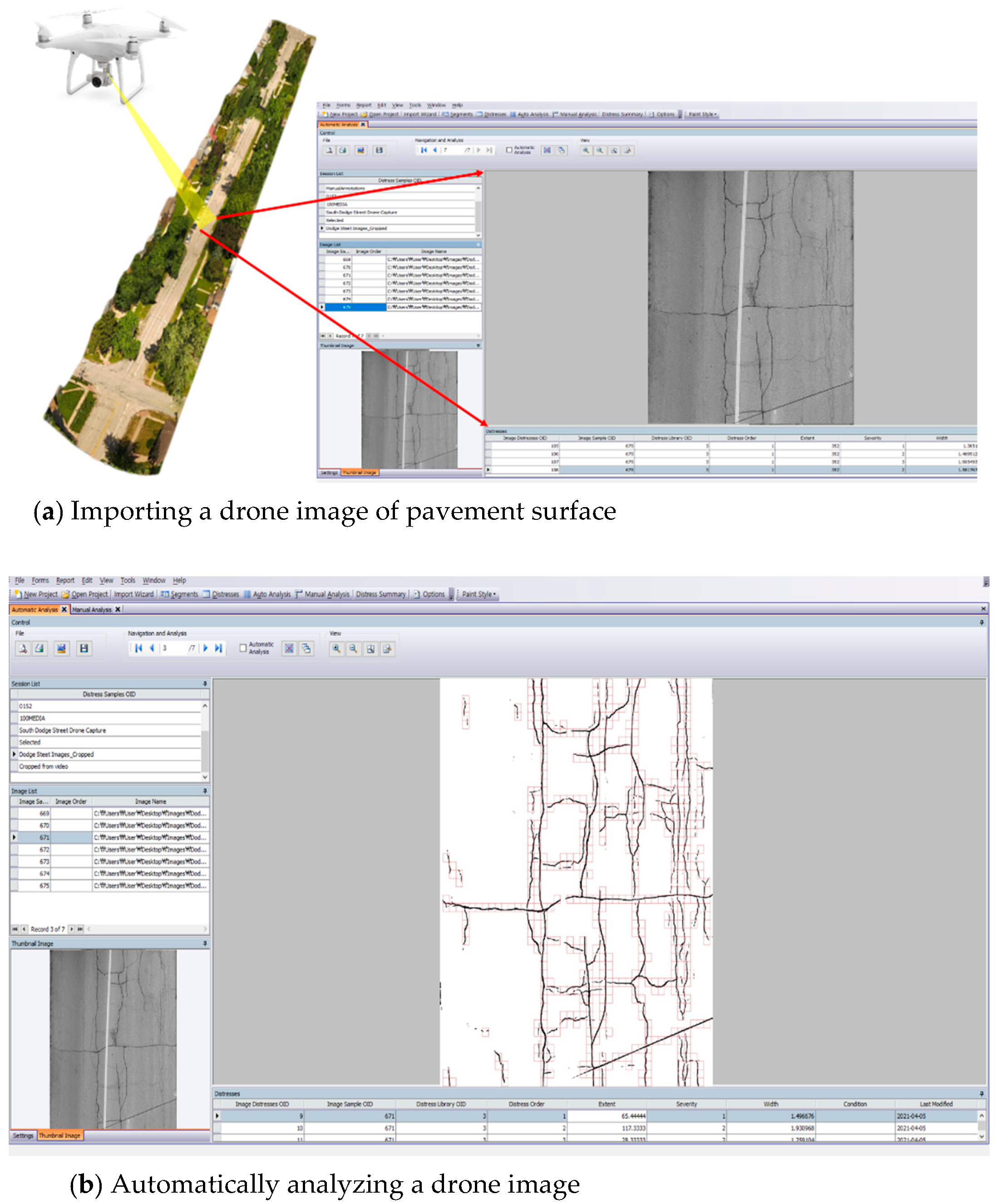
- Data Set Preparation
- (2)
- Pavement Extraction from Drone Images
- (3)
- Crack Detection
3. Summary and Conclusions
Author Contributions
Funding
Institutional Review Board Statement
Informed Consent Statement
Data Availability Statement
Conflicts of Interest
References
- Wilde, W.J.; Thompson, L.; Wood, T.J. Cost-Effective Pavement Preservation Solutions for the Real World; (No. MN/RC 2014-33); Department of Transportation: Washington, DC, USA., 2014. [Google Scholar]
- Albitres CM, C.; Smith, R.E.; Pendleton, O.J. Comparison of automated pavement distress data collection procedures for local agencies in San Francisco Bay Area, California. Transp. Res. Rec. 2007, 1990, 119–126. [Google Scholar] [CrossRef] [Green Version]
- Jitprasithsiri, S.; Lee, H.; Sorcic, R.G. Development of Digital Image Processing Algorithm to Compute a Unified Crack Index for Salt Lake City. Transp. Res. Rec. 1996, 1526, 142–148. [Google Scholar] [CrossRef]
- Lee, B.J.; Lee, H. A Robust Position Invariant Neural Network for Digital Pavement Crack Analysis. In Computer-Aided Civil and Infrastructure Engineering; Blackwell Publishing: Hoboken, NJ, USA, 2004; Volume 19, pp. 105–118. [Google Scholar]
- Lee, H.; Kim, J. Development of crack type index. Transp. Res. Rec. 2005, 1940, 99–109. [Google Scholar] [CrossRef]
- Lee, H.; Kim, J. Analysis of Errors in Ground Truth Indicators for Evaluating the Accuracy of Automated Pavement Surface Image Collection and Analysis System for Asset Management. J. ASTM Int. 2006, 3, 1–15. [Google Scholar] [CrossRef]
- Raman, M.; Hossain, M.; Miller, R.; Cumberledge, G.; Lee, H.; Kang, K. Assessment of Image-Based data Collection and the AASHTO Provisional Standard for Cracking on Asphalt-Surfaced Pavements. Transp. Res. Rec. 2004, 1889, 116–125. [Google Scholar] [CrossRef]
- Fischer, S.; Lu, J.; Van Fossen, K.; Lawless, E. Global Benchmarking Study on Unmanned Aerial Systems for Surface Transportation: Domestic Desk Review; (No. FHWA-HIF-20-091); Federal Highway Administration: Washington, DC, USA, 2020. [Google Scholar]
- Mogawer, W.S.; Xie, Y.; Austerman, A.J.; Dill, C.; Jiang, L.; Gittings, J.E. The Application of Unmanned Aerial Systems In Surface Transportation-Volume II-B: Assessment of Roadway Pavement Condition with UAS; (No. 19-010); University of Massachusetts: Lowell, MA, USA, 2019. [Google Scholar]

Publisher’s Note: MDPI stays neutral with regard to jurisdictional claims in published maps and institutional affiliations. |
© 2022 by the authors. Licensee MDPI, Basel, Switzerland. This article is an open access article distributed under the terms and conditions of the Creative Commons Attribution (CC BY) license (https://creativecommons.org/licenses/by/4.0/).
Share and Cite
Moon, B.; Lee, H. Drone-Image Based Fast Crack Analysis Algorithm Using Machine Learning for Highway Pavements. Eng. Proc. 2022, 17, 15. https://doi.org/10.3390/engproc2022017015
Moon B, Lee H. Drone-Image Based Fast Crack Analysis Algorithm Using Machine Learning for Highway Pavements. Engineering Proceedings. 2022; 17(1):15. https://doi.org/10.3390/engproc2022017015
Chicago/Turabian StyleMoon, Byungkyu, and Hosin (David) Lee. 2022. "Drone-Image Based Fast Crack Analysis Algorithm Using Machine Learning for Highway Pavements" Engineering Proceedings 17, no. 1: 15. https://doi.org/10.3390/engproc2022017015
APA StyleMoon, B., & Lee, H. (2022). Drone-Image Based Fast Crack Analysis Algorithm Using Machine Learning for Highway Pavements. Engineering Proceedings, 17(1), 15. https://doi.org/10.3390/engproc2022017015