

Beyond the Tide: A Comprehensive Guide to Sea-Level-Rise Inundation Mapping Using FOSS4G


Abstract
:1. Introduction
1.1. Previous Work
1.2. Contribution and Significance of Study
2. Materials and Methods
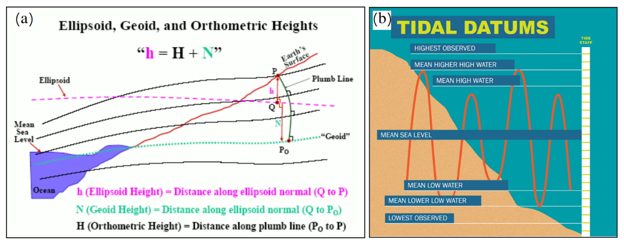
2.1. Surface and Water Elevation Data
2.2. Bathtub Approach to Mapping SLR Inundation
2.2.1. Limitations of the Bathtub Mapping Approach
- The approach relies on static input data; however, over time, natural and artificial processes can significantly alter the landscape, potentially leading to inaccurate flood predictions.
- The approach does not consider the dynamic interplay of water flow, wave action, and wind. This can lead to an oversimplification of flood scenarios, especially in areas prone to storm surges or rapidly changing water levels.
- We assume a universal rise in water levels across the entire study domain; however, factors such as tidal variations, river discharges, and localized rainfall can cause significant disparities in water-level changes across a region. This is more prominent over large study areas.
- The accuracy and resolution of the data inputs, such as DEMs, directly impact the reliability of passive inundation models.
- The current approach does not account for spatial variations in land cover and other environmental factors; however, the grid-based approach can be extended to include these.
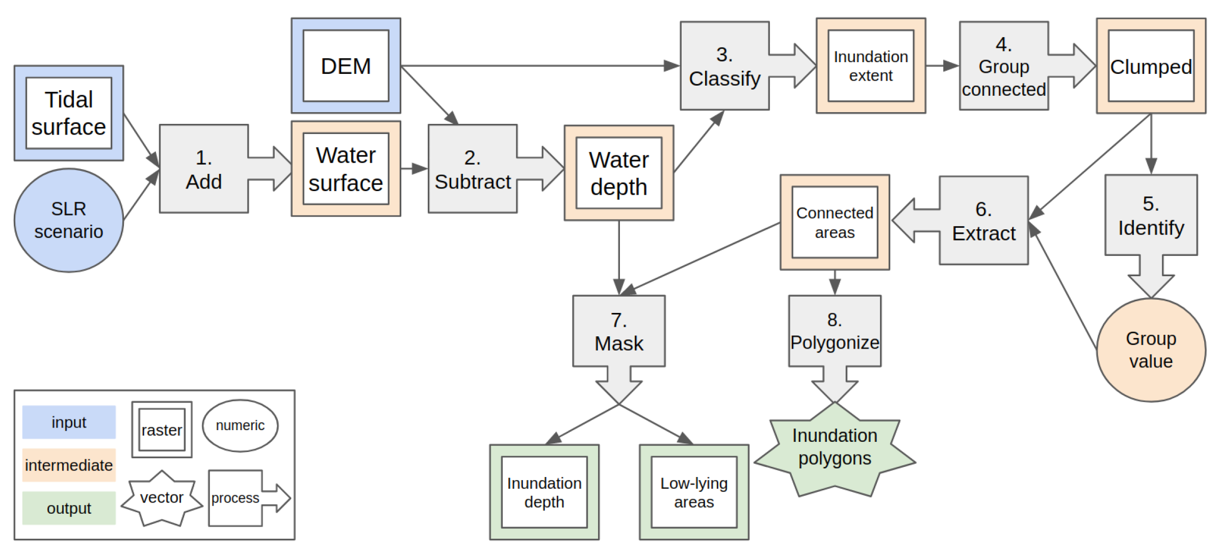
2.3. FOSS4G Implementation
Software and Tools
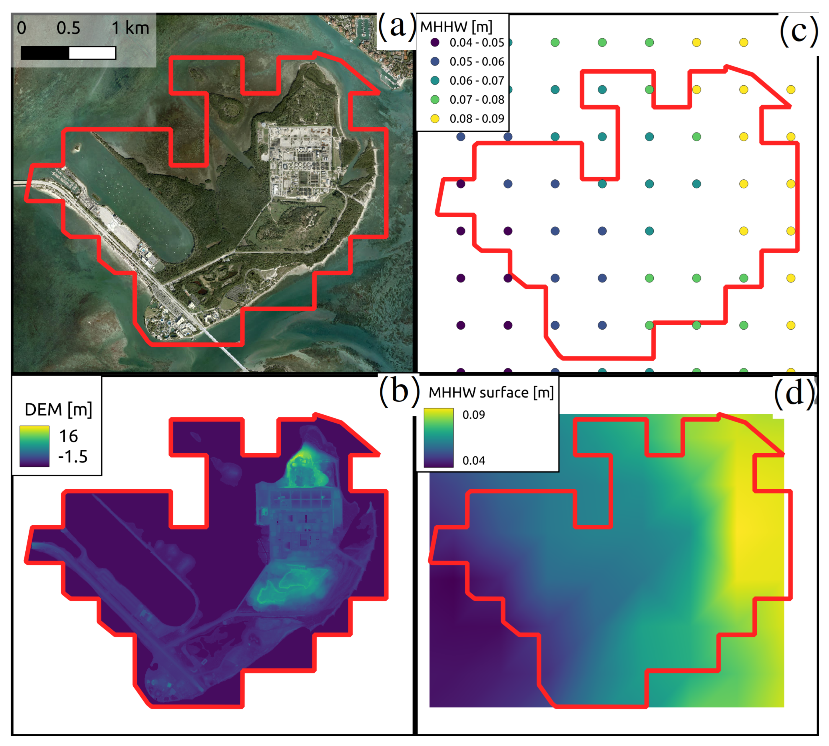
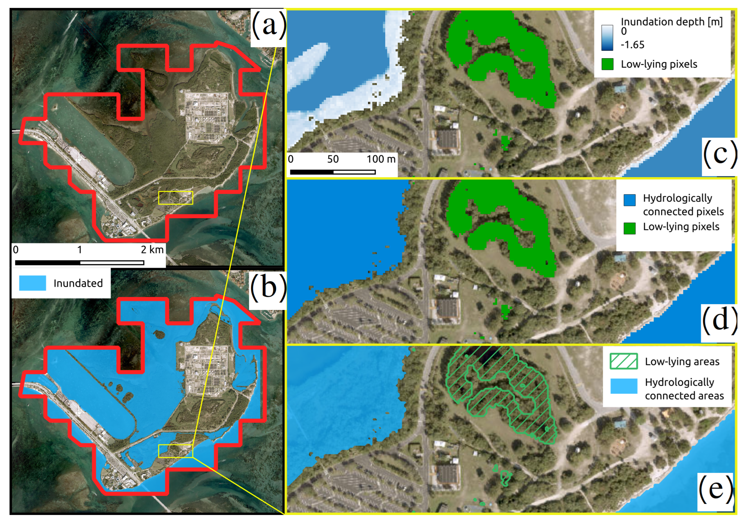
2.4. Description of the Case Study
3. Results
3.1. Preparation of the Datasets
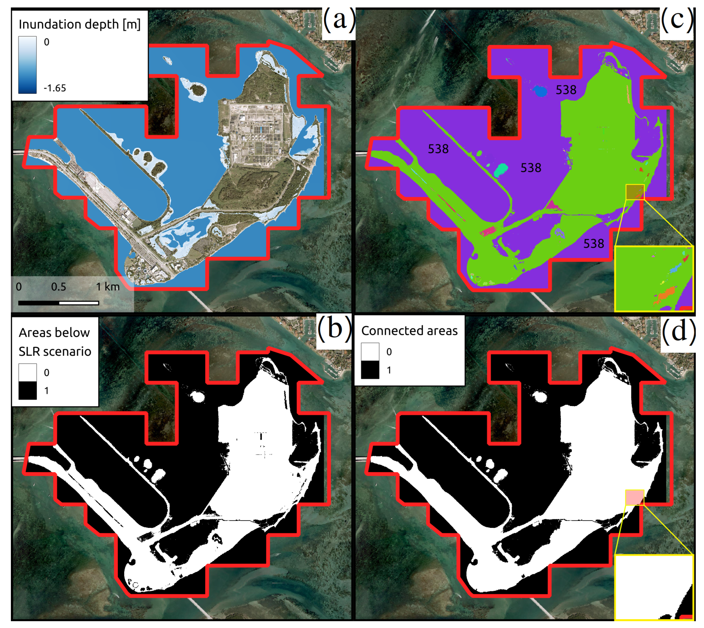
3.2. Simulating SLR Inundation
3.3. Visualization of SLR and Low-Lying Areas
4. Discussion and Conclusions
Author Contributions
Funding
Institutional Review Board Statement
Informed Consent Statement
Data Availability Statement
Conflicts of Interest
Appendix A. FOSS4G Implementation
- QGIS 3.34.0-Prizren;
- GRASS GIS 7.8.7;
- GDAL/OGR 3.4.1.
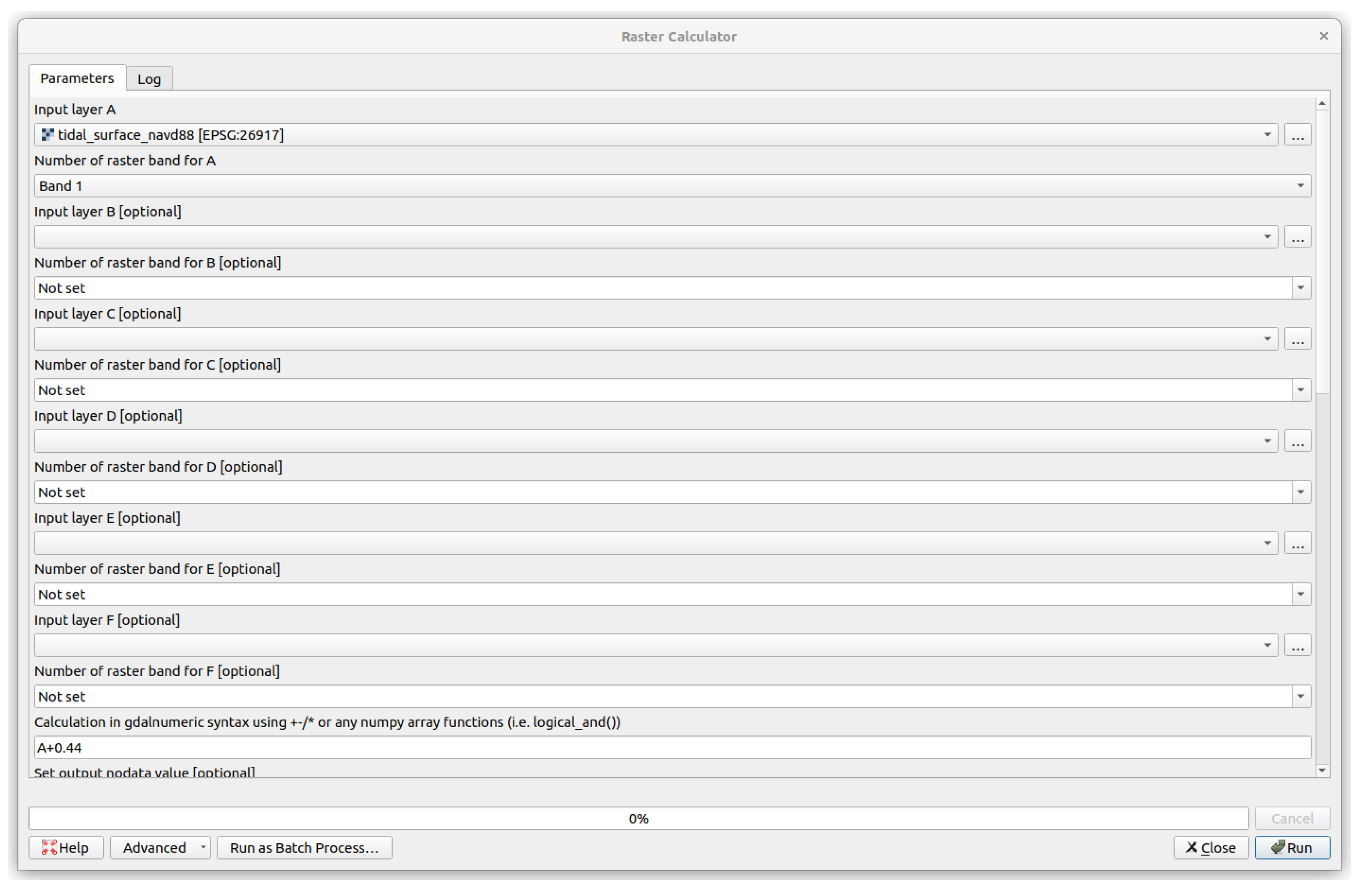
Appendix A.1. Step 1
- gdal_calc.py --co COMPRESS=DEFLATE --calc=A+0.44 \
- --outfile=water_surface.tif -A tidal_surface_navd88.tif

Appendix A.2. Step 2
- gdal_calc.py --co COMPRESS=DEFLATE --calc="(A <= B) ∗ (A - B)" \
- --outfile=depth.tif -A project_dem_metric.tif \
- -B water_surface.tif
Appendix A.3. Step 3
- gdal_calc.py --co COMPRESS=DEFLATE --calc="(A <= B) ∗ 1" \
- --outfile=single.tif -A project_dem_metric.tif \
- -B water_surface.tif
Appendix A.4. Step 4
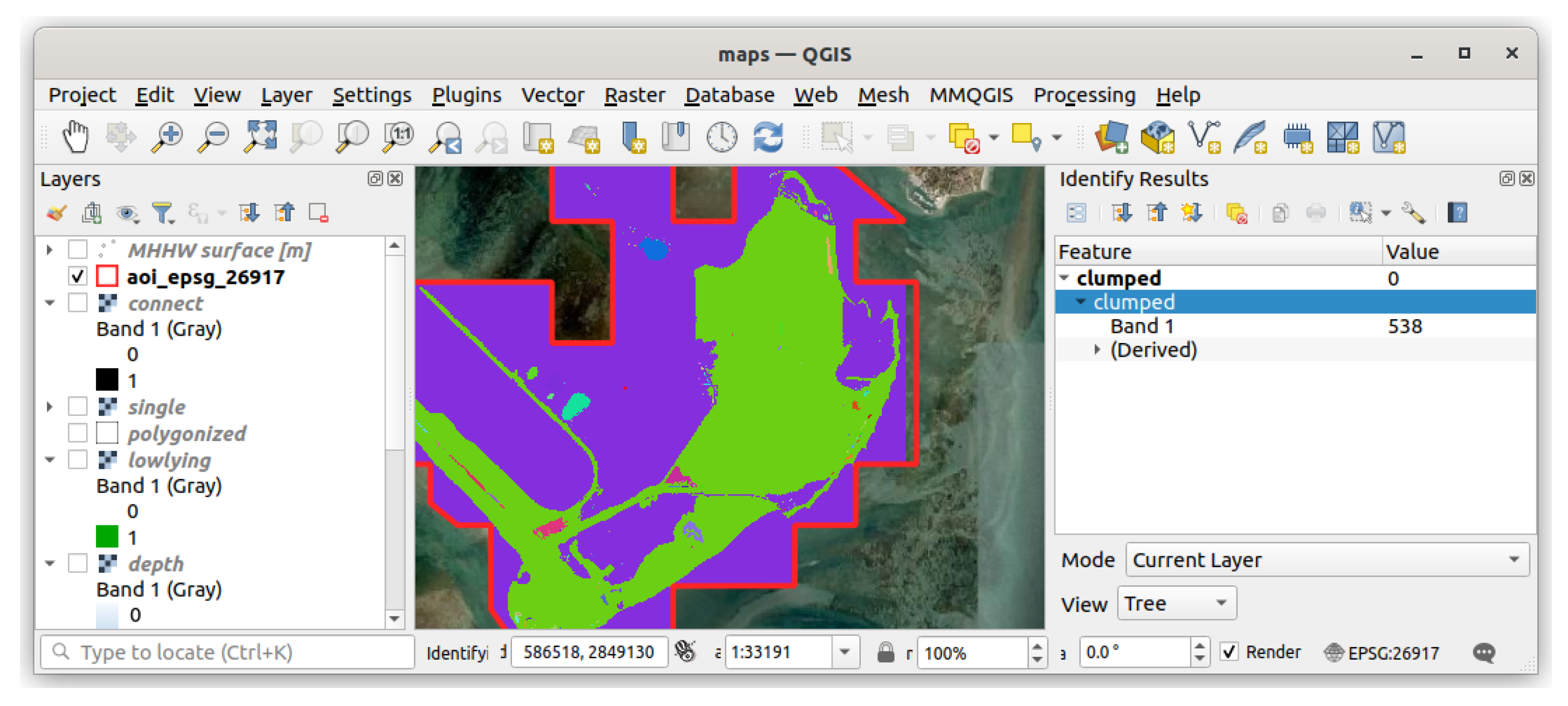
- Listing 4: Running the r.clump GRASS GIS algorithm through a QGIS process on the command line
- qgis_process run grass7:r.clump --distance_units=meters \
- --area_units=m2 --ellipsoid=EPSG:7019 --input=single.tif \
- --title=clumped.tif ---d=true --output=clumped.tif \
- --threshold=0 --GRASS_REGION_CELLSIZE_PARAMETER=0 \
- --GRASS_RASTER_FORMAT_OPT=‘COMPRESS=DEFLATE’
Appendix A.5. Step 5

Appendix A.6. Step 6
- Listing 5: Using raster algebra with gdal_calc to retain hydrologically connected areas
- gdal_calc.py --NoDataValue "65535" --co COMPRESS=DEFLATE \
- --calc="(A == 538) ∗ 1" --outfile=connect.tif -A clumped.tif
Appendix A.7. Step 7
- gdal_calc.py --NoDataValue "65535" --co COMPRESS=DEFLATE \
- --calc="(A == 1) ∗ (B == 0) " --outfile=lowlying.tif \
- -A single.tif -B connect.tif
Appendix A.8. Step 8
- Listing 7: Running the r.to.vect GRASS GIS algorithm through a QGIS process to vectorize a rester
- qgis_process run grass7:r.to.vect --distance_units=meters \
- --area_units=m2 --ellipsoid=EPSG:7019 --input=connect.tif \
- --type=2 --column=value ---s=true ---v=false ---z=false \
- ---b=false ---t=false --output=polygonized.shp \
- --GRASS_REGION_CELLSIZE_PARAMETER=0 \
- --GRASS_OUTPUT_TYPE_PARAMETER=3 --GRASS_VECTOR_DSCO= \
- --GRASS_VECTOR_LCO= --GRASS_VECTOR_EXPORT_NOCAT=false
- ogr2ogr -where "\"cat\" = 1" inundated.shp polygonized.shp
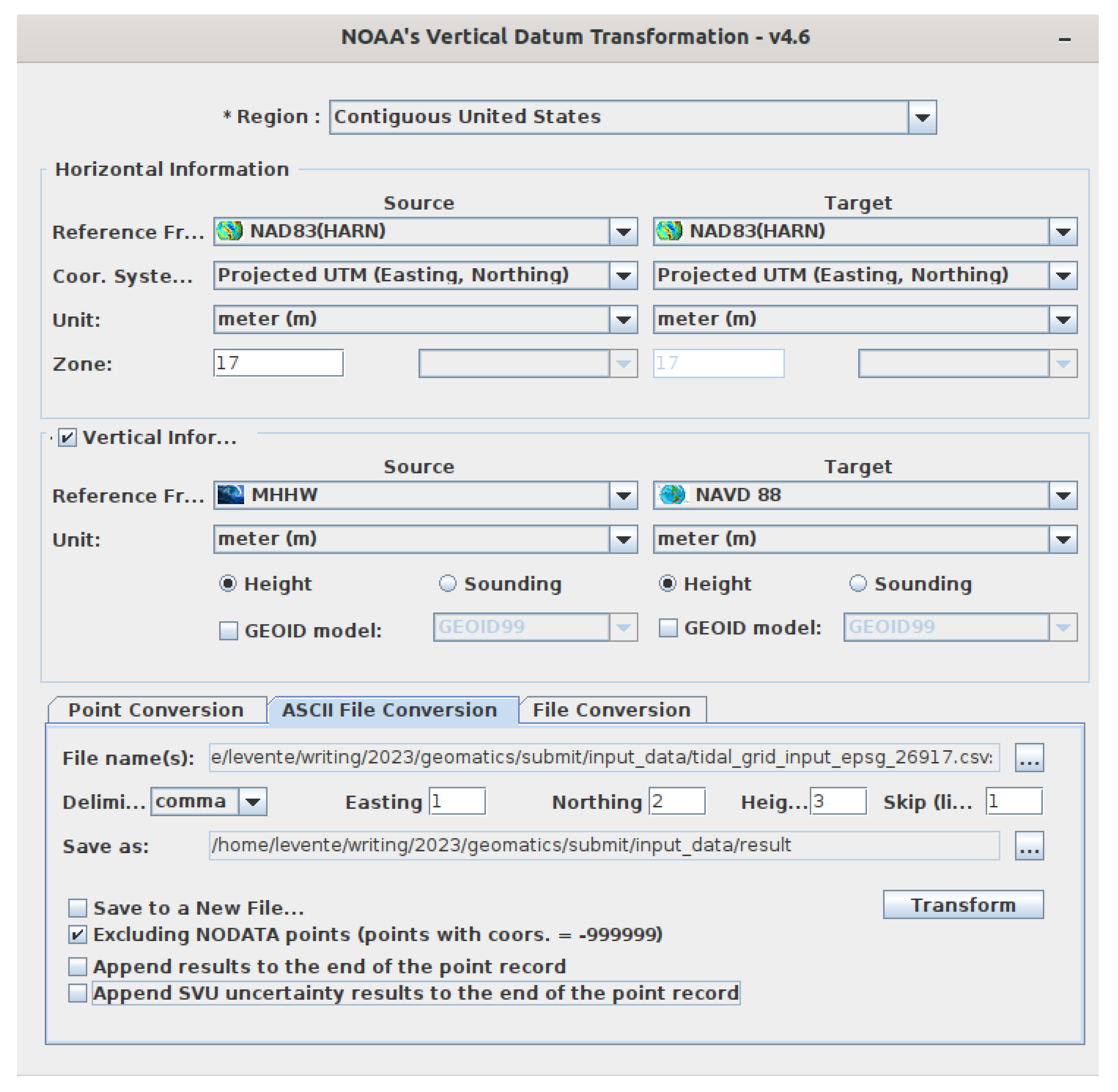
Appendix B. VDatum

References
- Sobel, A.H.; Camargo, S.J.; Hall, T.M.; Lee, C.Y.; Tippett, M.K.; Wing, A.A. Human influence on tropical cyclone intensity. Science 2016, 353, 242–246. [Google Scholar] [CrossRef] [PubMed]
- Xi, D.; Lin, N.; Gori, A. Increasing sequential tropical cyclone hazards along the US East and Gulf coasts. Nat. Clim. Chang. 2023, 13, 258–265. [Google Scholar] [CrossRef]
- Overland, J.; Dunlea, E.; Box, J.E.; Corell, R.; Forsius, M.; Kattsov, V.; Olsen, M.S.; Pawlak, J.; Reiersen, L.O.; Wang, M. The urgency of Arctic change. Polar Sci. 2019, 21, 6–13. [Google Scholar] [CrossRef]
- Bushard, B. Record-Breaking Summer: Jacksonville, Miami Break Daily High Temperature Records, after Hottest July Ever. Forbes. 4 September 2023. Available online: https://www.forbes.com/sites/brianbushard/2023/08/09/miami-phoenix-new-orleans-break-daily-high-temperature-records-heres-where-else-daily-records-have-fallen/ (accessed on 3 November 2023).
- Fortin, J.F.; Gahan, M.B. Phoenix Breaks Heat Record Set in 1974. The New York Times. 18 July 2023. Available online: https://www.nytimes.com/2023/07/18/us/phoenix-heat-record.html/ (accessed on 3 November 2023).
- Small, C.; Gornitz, V.; Cohen, J.E. Coastal hazards and the global distribution of human population. Environ. Geosci. 2000, 7, 3–12. [Google Scholar] [CrossRef]
- Ketabchi, H.; Mahmoodzadeh, D.; Ataie-Ashtiani, B.; Simmons, C.T. Sea-level rise impacts on seawater intrusion in coastal aquifers: Review and integration. J. Hydrol. 2016, 535, 235–255. [Google Scholar] [CrossRef]
- Snoussi, M.; Ouchani, T.; Niazi, S. Vulnerability assessment of the impact of sea-level rise and flooding on the Moroccan coast: The case of the Mediterranean eastern zone. Estuar. Coast. Shelf Sci. 2008, 77, 206–213. [Google Scholar] [CrossRef]
- Daniels, R.C.; White, T.W.; Chapman, K.K. Sea-level rise: Destruction of threatened and endangered species habitat in South Carolina. Environ. Manag. 1993, 17, 373–385. [Google Scholar] [CrossRef]
- Parkinson, R.W.; Wdowinski, S. Accelerating sea-level rise and the fate of mangrove plant communities in South Florida, U.S.A. Geomorphology 2022, 412, 108329. [Google Scholar] [CrossRef]
- French, G.T.; Awosika, L.F.; Ibe, C. Sea-level rise and Nigeria: Potential impacts and consequences. J. Coast. Res. 1995, 224–242. [Google Scholar]
- Williams, L.L.; Lück-Vogel, M. Comparative assessment of the GIS based bathtub model and an enhanced bathtub model for coastal inundation. J. Coast. Conserv. 2020, 24, 23. [Google Scholar] [CrossRef]
- Jelesnianski, C.P. SLOSH: Sea, Lake, and Overland Surges from Hurricanes; NOAA Technical Report NWS 48; US Department of Commerce, National Oceanic and Atmospheric Administration: Silver Spring, MD, USA, 1992. [Google Scholar]
- Roelvink, J.; Van Banning, G. Design and development of DELFT3D and application to coastal morphodynamics. Oceanogr. Lit. Rev. 1995, 11, 925. [Google Scholar]
- Luettich, R.A.; Westerink, J.J.; Scheffner, N.W. ADCIRC: An Advanced Three-Dimensional Circulation Model for Shelves, Coasts, and Estuaries. Report 1, Theory and Methodology of ADCIRC-2DD1 and ADCIRC-3DL; US Army Corps of Engineers: Washington, DC, USA, 1992. [Google Scholar]
- Mcleod, E.; Poulter, B.; Hinkel, J.; Reyes, E.; Salm, R. Sea-level rise impact models and environmental conservation: A review of models and their applications. Ocean. Coast. Manag. 2010, 53, 507–517. [Google Scholar] [CrossRef]
- Reyes, E.; White, M.L.; Martin, J.F.; Kemp, G.P.; Day, J.W.; Aravamuthan, V. Landscape modeling of coastal habitat change in the Mississippi Delta. Ecology 2000, 81, 2331–2349. [Google Scholar] [CrossRef]
- Martin, J.F.; White, M.L.; Reyes, E.; Kemp, G.P.; Mashriqui, H.; Day, J.W., Jr. Evaluation of Coastal Management Plans with a Spatial Model: Mississippi Delta, Louisiana, USA. Environ. Manag. 2000, 26, 117–129. [Google Scholar] [CrossRef]
- Feenstra, J.F. Handbook on Methods for Climate Change Impact Assessment and Adaptation Strategies; United Nations Environment Programme: Nairobi, Kenya, 1998. [Google Scholar]
- Cartwright, A.; Brundrit, G.; Fairhurst, L. Global climate change and adaptation—A sea-level rise risk assessment. In Phase Four: Adaptation and Risk Mitigation Measures for the City of Cape Town; Prepared for the City of Cape Town by LaquaR Consultants CC; Stockholm Environment Institute: Stockholm, Sweden, 2008. [Google Scholar]
- Hinkel, J.; Nicholls, R.J.; Vafeidis, A.T.; Tol, R.S.; Avagianou, T. Assessing risk of and adaptation to sea-level rise in the European Union: An application of DIVA. Mitig. Adapt. Strateg. Glob. Chang. 2010, 15, 703–719. [Google Scholar] [CrossRef]
- Brown, S.; Nicholls, R.J.; Lowe, J.A.; Hinkel, J. Spatial variations of sea-level rise and impacts: An application of DIVA. Clim. Chang. 2016, 134, 403–416. [Google Scholar] [CrossRef]
- Juhász, L.; Podolcsák, A.; Doleschall, J. Open Source Web GIS Solutions in Disaster Management–with Special Emphasis on Inland Excess Water Modeling. J. Environ. Geogr. 2016, 9, 15–21. [Google Scholar] [CrossRef]
- Ramanayake, K.; Vithanage, D.; Hettiarachchi, N.; Rathnayake, G.; Rajapaksha, S.; Fernando, N. Geo-enabled FOSS tool supports for immediate flood disaster response planning. In Proceedings of the 7th International Conference on Information and Automation for Sustainability, Colombo, Sri Lanka, 22–24 December 2014; pp. 1–6. [Google Scholar] [CrossRef]
- Dutta, U.; Singh, Y.K.; Prabhu, T.S.M.; Yendargaye, G.; Kale, R.G.; Kumar, B.; Khare, M.; Yadav, R.; Khattar, R.; Samal, S.K. Flood Forecasting in Large River Basins Using FOSS Tool and HPC. Water 2021, 13, 3484. [Google Scholar] [CrossRef]
- Lichter, M.; Felsenstein, D. Assessing the costs of sea-level rise and extreme flooding at the local level: A GIS-based approach. Ocean. Coast. Manag. 2012, 59, 47–62. [Google Scholar] [CrossRef]
- Li, X.; Grady, C.; Peterson, A.T. Delineating sea level rise inundation using a graph traversal algorithm. Mar. Geod. 2014, 37, 267–281. [Google Scholar] [CrossRef]
- Perini, L.; Calabrese, L.; Salerno, G.; Ciavola, P.; Armaroli, C. Evaluation of coastal vulnerability to flooding: Comparison of two different methodologies adopted by the Emilia-Romagna region (Italy). Nat. Hazards Earth Syst. Sci. 2016, 16, 181–194. [Google Scholar] [CrossRef]
- NOAA. Detailed Method for Mapping Sea Level Rise Inundation. In Method Description; NOAA Office for Coastal Management: Washington, DC, USA, 2017. Available online: https://coast.noaa.gov/data/digitalcoast/pdf/slr-inundation-methods.pdf (accessed on 3 November 2023).
- Styrin, E.; Luna-Reyes, L.F.; Harrison, T.M. Open data ecosystems: An international comparison. Transform. Gov. People Process. Policy 2017, 11, 132–156. [Google Scholar] [CrossRef]
- Rajabifard, A.; Binns, A.; Masser, I.; Williamson, I. The role of sub-national government and the private sector in future spatial data infrastructures. Int. J. Geogr. Inf. Sci. 2006, 20, 727–741. [Google Scholar] [CrossRef]
- Goodchild, M.F.; Fu, P.; Rich, P. Sharing geographic information: An assessment of the Geospatial One-Stop. Ann. Assoc. Am. Geogr. 2007, 97, 250–266. [Google Scholar] [CrossRef]
- The Geospatial Data Act of 2018. (P.L. 115-254), H.R. 302, Subtitle F, Sections 751–759. 2018. Available online: https://www.fgdc.gov/gda/online#:~:text=Extract%20of%20%E2%80%9CGeospatial%20Data%20Act,F%2C%20Sections%20751%20%E2%80%93%20759 (accessed on 3 November 2023).
- Choi, J.; Ahn, J.; Kim, H. A Cross National Comparison on the Awareness of Adopting FOSS4G to NSDI in Developing Countries. In Proceedings of the Free and Open Source Software for Geospatial (FOSS4G) Conference Proceedings, Seoul, Republic of Korea, 14–19 September 2015; Volume 15, p. 36. [Google Scholar] [CrossRef]
- NOAA. A Tutorial on Datums. 2023. Available online: https://vdatum.noaa.gov/docs/datums.html (accessed on 3 November 2023).
- National Research Council. Mapping the Zone: Improving Flood Map Accuracy; National Academies Press: Washington, DC, USA, 2009. [Google Scholar] [CrossRef]
- Gesch, D.B.; Gutierrez, B.T.; Gill, S.K. Coastal Elevations. In Coastal Sensitivity to Sea-Level Rise: A Focus on the Mid-Atlantic Region; Titus, J.G., Anderson, K.E., Cahoon, D.R., Gesch, D.B., Gill, S.K., Gutierrez, B.T., Thieler, E.R., Williams, S.J., Eds.; U.S. Climate Change Science Program: Washington, DC, USA, 2009; pp. 25–42. [Google Scholar]
- NOAA. National Tidal Datum Epoch. 2023. Available online: https://tidesandcurrents.noaa.gov/datum-updates/ntde/ (accessed on 3 November 2023).
- Juhász, L.; Hochmair, H.H.; de Santana, S.A.; Fu, Z.J. Sea Level Rise Impact Assessment Tool—A Web-Based Application for Community Resilience in Coral Gables, Florida. Int. J. Spat. Data Infrastructures Res. 2020, 15, 36–55. [Google Scholar] [CrossRef]
- Danielson, J.J.; Poppenga, S.K.; Tyler, D.J.; Palaseanu-Lovejoy, M.; Gesch, D.B. Coastal National Elevation Database; USGS Fact Sheet 2018–3037; U.S. Geological Survey: Reston, VA, USA, 2018. [Google Scholar] [CrossRef]
- Cooper, H.M.; Fletcher, C.H.; Chen, Q.; Barbee, M.M. Sea-level rise vulnerability mapping for adaptation decisions using LiDAR DEMs. Prog. Phys. Geogr. Earth Environ. 2013, 37, 745–766. [Google Scholar] [CrossRef]
- Harris, D.L. Tides and Tidal Datums in the United States; Technical Report SR-7; United States Army Corps of Engineers, Coastal Engineering Research Center: Fort Belvoir, VA, USA, 1981. [Google Scholar]
- Adhikari, S.; Ivins, E.R.; Frederikse, T.; Landerer, F.W.; Caron, L. Sea-level fingerprints emergent from GRACE mission data. Earth Syst. Sci. Data 2019, 11, 629–646. [Google Scholar] [CrossRef]
- Katsman, C.A.; Sterl, A.; Beersma, J.J.; van den Brink, H.W.; Church, J.A.; Hazeleger, W.; Kopp, R.E.; Kroon, D.; Kwadijk, J.; Lammersen, R.; et al. Exploring high-end scenarios for local sea level rise to develop flood protection strategies for a low-lying delta—the Netherlands as an example. Clim. Chang. 2011, 109, 617–645. [Google Scholar] [CrossRef]
- Shen, S.; Kim, K. Assessment of Transportation System Vulnerabilities to Tidal Flooding in Honolulu, Hawaii. Transp. Res. Rec. 2020, 2674, 207–219. [Google Scholar] [CrossRef]
- Parker, B.; Milbert, D.; Hess, K.; Gill, S. National VDatum—The implementation of a national vertical datum transformation database. In Proceedings of the Proceeding from the US Hydro’2003 Conference, Biloxi, MS, USA, 24–27 March 2003; Available online: https://vdatum.noaa.gov/download/publications/2003_parker_USHydro_nationalvdatum.pdf (accessed on 3 November 2023).
- Paoa, N.; Fletcher, C.H.; Anderson, T.R.; Coffman, M.; Habel, S. Probabilistic sea level rise flood projections using a localized ocean reference surface. Sci. Rep. 2023, 13, 2257. [Google Scholar] [CrossRef]
- SeaGIS. AusCoastVDT, Software Version 1.20, Grid Version 3.0, User Manual Version 1.3. 2019. Available online: https://www.icsm.gov.au/sites/default/files/AusCoastVDT_v1.20.zip (accessed on 3 November 2023).
- Canadian Geodetic Survey. Vertical Datum Transformations. 2022. Available online: https://webapp.csrs-scrs.nrcan-rncan.gc.ca/geod/data-donnees/datum-transformation.php?locale=en (accessed on 3 November 2023).
- NOAA. NOAA/NOS/CO-OPS Datums for Station 8723214, Virginia Key, Biscayne Bay FL. 2023. Available online: https://tidesandcurrents.noaa.gov/datums.html?id=8723214 (accessed on 3 November 2023).
- Zhang, K.; Dittmar, J.; Ross, M.; Bergh, C. Assessment of sea level rise impacts on human population and real property in the Florida Keys. Clim. Chang. 2011, 107, 129–146. [Google Scholar] [CrossRef]
- Warmerdam, F. The geospatial data abstraction library. In Open Source Approaches in Spatial Data Handling; Advances in Geographic Information Science; Hall, G.B., Leahy, M.G., Eds.; Springer: Berlin/Heidelberg, Germany, 2008; Volume 2, pp. 87–104. [Google Scholar] [CrossRef]
- Neteler, M.; Bowman, M.H.; Landa, M.; Metz, M. GRASS GIS: A multi-purpose open source GIS. Environ. Model. Softw. 2012, 31, 124–130. [Google Scholar] [CrossRef]
- Flenniken, J.M.; Stuglik, S.; Iannone, B.V. Quantum GIS (QGIS): An introduction to a free alternative to more costly GIS platforms: FOR359/FR428, 2/2020. EDIS 2020, 2020, 7. [Google Scholar] [CrossRef]
- Sweet, W.; Hamlington, B.; Kopp, R.; Weaver, C.; Barnard, P.; Bekaert, D.; Brooks, W.; Craghan, M.; Dusek, G.; Frederikse, T.; et al. Global and Regional Sea Level Rise Scenarios for the United States: Updated Mean Projections and Extreme Water Level Probabilities Along U.S. Coastlines; NOAA Technical Report NOS 01; National Oceanic and Atmospheric Administration, National Ocean Service: Silver Spring, MD, USA, 2022. [Google Scholar]
- GPI Geospatial Inc. Miami-Dade County LiDAR DEM; Miami-Dade Open Data Hub: Miami, FL, USA, 2021; Available online: https://mdc.maps.arcgis.com/home/item.html?id=8c48d4bb8d9a42908f4936f698a2961a (accessed on 3 November 2023).
- Gill, S.K.; Schultz, J.R. Tidal Datums and Their Applications; Report; NOAA, NOS Center for Operational Oceanographic Products and Services: Washington, DC, USA, 2001. [Google Scholar] [CrossRef]
- Zhang, K. Analysis of non-linear inundation from sea-level rise using LIDAR data: A case study for South Florida. Clim. Chang. 2011, 106, 537–565. [Google Scholar] [CrossRef]
- Ann Conyers, Z.; Grant, R.; Roy, S.S. Sea level rise in Miami Beach: Vulnerability and real estate exposure. Prof. Geogr. 2019, 71, 278–291. [Google Scholar] [CrossRef]
- NOAA. Technical Considerations for Use of Geospatial Data in Sea Level Change Mapping and Assessment; NOAA Technical Report NOS 2010-1; NOAA: Washington, DC, USA, 2010. [Google Scholar]
- Marcy, D.; Brooks, W.; Draganov, K.; Hadley, B.; Haynes, C.; Herold, N.; McCombs, J.; Pendleton, M.; Ryan, S.; Schmid, K.; et al. New Mapping Tool and Techniques for Visualizing Sea Level Rise and Coastal Flooding Impacts. In Solutions to Coastal Disasters 2011; ASCE: Anchorage, AK, USA, 2011; pp. 474–490. [Google Scholar] [CrossRef]


| Datum | Description | Value [m] |
|---|---|---|
| Max. Tide | Highest Observed Tide | 1.09 |
| MHHW | Mean Higher High Water | 0.00 |
| MHW | Mean High Water | −0.02 |
| NAVD88 1 | North American Vertical Datum of 1988 | −0.07 |
| MSL | Mean Sea Level | −0.34 |
| MLW | Mean Low Water | −0.64 |
| MLLW | Mean Lower Low Water | −0.68 |
| Min. Tide | Minimum Observed Tide | −1.08 |
| STDT | Station Datum | −3.77 |
| Step | Description | Input(s) | Output(s) | Software | Tool |
|---|---|---|---|---|---|
| 1 | Add SLR scenario to tidal surface raster | Tidal surface (raster) SLR value (numeric) | Water surface (raster) | GDAL | gdal_calc |
| 2 | Subtract DEM from water surface | Water surface (raster) DEM | Inundation depth (raster) | GDAL | gdal_calc |
| 3 | Create inundation extent | Inundation depth (raster) DEM | Binary water extent (raster) | GDAL | gdal_calc |
| 4 | Group connected cells | Binary water extent (raster) | Clumped (raster) | GRASS GIS | r.clump |
| 5 | Identify hydrologically connected areas | Clumped (raster) | Max value (numeric) | QGIS GDAL | identify gdalinfo |
| 6 | Extract hydrologically connected water surface | Clumped (raster) Max value (numeric) | Connected areas (raster) | GDAL | gdal_calc |
| 7 | Conflate water depth with inundation mask | Connected areas (raster) Water depth (raster) | Inundation depth (raster) Low-lying areas (raster) | GDAL | gdal_calc |
| 8 * | Polygonize inundation extent | Inundated areas (raster) | Inundation areas (vector) | GRASS GIS GDAL/OGR | r.to.vect ogr2ogr |
Disclaimer/Publisher’s Note: The statements, opinions and data contained in all publications are solely those of the individual author(s) and contributor(s) and not of MDPI and/or the editor(s). MDPI and/or the editor(s) disclaim responsibility for any injury to people or property resulting from any ideas, methods, instructions or products referred to in the content. |
© 2023 by the authors. Licensee MDPI, Basel, Switzerland. This article is an open access article distributed under the terms and conditions of the Creative Commons Attribution (CC BY) license (https://creativecommons.org/licenses/by/4.0/).
Share and Cite
Juhász, L.; Xu, J.; Parkinson, R.W. Beyond the Tide: A Comprehensive Guide to Sea-Level-Rise Inundation Mapping Using FOSS4G. Geomatics 2023, 3, 522-540. https://doi.org/10.3390/geomatics3040028
Juhász L, Xu J, Parkinson RW. Beyond the Tide: A Comprehensive Guide to Sea-Level-Rise Inundation Mapping Using FOSS4G. Geomatics. 2023; 3(4):522-540. https://doi.org/10.3390/geomatics3040028
Chicago/Turabian StyleJuhász, Levente, Jinwen Xu, and Randall W. Parkinson. 2023. "Beyond the Tide: A Comprehensive Guide to Sea-Level-Rise Inundation Mapping Using FOSS4G" Geomatics 3, no. 4: 522-540. https://doi.org/10.3390/geomatics3040028
APA StyleJuhász, L., Xu, J., & Parkinson, R. W. (2023). Beyond the Tide: A Comprehensive Guide to Sea-Level-Rise Inundation Mapping Using FOSS4G. Geomatics, 3(4), 522-540. https://doi.org/10.3390/geomatics3040028