


Geomatics 2025, 5(1), 7; https://doi.org/10.3390/geomatics5010007 (registering DOI) - 31 Jan 2025
Abstract
Semantic segmentation of remotely sensed images for building footprint recognition has been extensively researched, and several supervised and unsupervised approaches have been presented and adopted. The capacity to do real-time mapping and precise segmentation on a significant scale while considering the intrinsic diversity
[...] Read more.
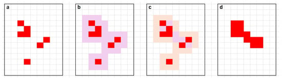
Semantic segmentation of remotely sensed images for building footprint recognition has been extensively researched, and several supervised and unsupervised approaches have been presented and adopted. The capacity to do real-time mapping and precise segmentation on a significant scale while considering the intrinsic diversity of the urban landscape in remotely sensed data has significant consequences. This study presents a novel approach for delineating building footprints by utilizing the compressed sensing and radial basis function technique. At the feature extraction stage, a small set of random features of the built-up areas is extracted from local image windows. The random features are used to train a radial basis neural network to perform building classification; thus, learning and classification are carried out in the compressed sensing domain. By virtue of its ability to represent characteristics in a reduced dimensional space, the scheme shows promise in being robust in the face of variability inherent in urban remotely sensed images. Through a comparison of the proposed method with numerous state-of-the-art approaches utilizing remotely sensed data of different spatial resolutions and building clutter, we establish its robustness and prove its viability. Accuracy assessment is performed for segmented footprints, and comparative analysis is carried out in terms of intersection over union, overall accuracy, precision, recall, and F1 score. The proposed method achieved scores of 93% in overall accuracy, 90.4% in intersection over union, and 91.1% in F1 score, even when dealing with drastically different image features. The results demonstrate that the proposed methodology yields substantial enhancements in classification accuracy and decreases in feature dimensionality.
Full article


